Showing 491 items matching "bay view street"
-
 City of Moorabbin Historical Society (Operating the Box Cottage Museum)
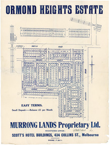
Flyer - Ormond Heights, East Bentleigh
... ...Bay View Street...Example of the progress of the Municipality of Moorabbin North Road Moulden Street George Street Garden Road Bruce Street (now Bethwyn Street) Boundary Road (now East Boundary Road) Murrong Avenue Bay View Street Rochford Street Mitchell Street Lancaster Street East Bentleigh Real Estate Advertising flyer for auction of real estate sales - plan of building blocks for sale Flyer Ormond Heights, East Bentleigh ...The train line from the city to Frankston was electrified which intensified the sale in the municipality of Moorabbin, particularly land which was in the vicinity of the railway stations.Example of the progress of the Municipality of MoorabbinAdvertising flyer for auction of real estate sales - plan of building blocks for salenorth road, moulden street, george street, garden road, bruce street (now bethwyn street), boundary road (now east boundary road), murrong avenue, bay view street, rochford street, mitchell street, lancaster street, east bentleigh, real estate -
 Port Melbourne Historical & Preservation Society
Postcard - Public Transport Victoria, stylised view of Bay Street, Port Melbourne, Public Transport Victoria, 2017
... Public Transport Victoria, stylised view of Bay Street, Port Melbourne...Bay Street Port Melbourne melbourne built environment bay street public transport victoria "Take a stroll under the palms of Port Melbourne. Explore the world of Melbourne by bus." Art deco style representation of Bay Street Port Melbourne with palm trees, bus and Mediterranean looking buildings. yachts in the Bay and moon rising behind land. Reverse side pale blue with text (Charles Rennie Macintosh style font) Postcard Public Transport Victoria, stylised view ...Art deco style representation of Bay Street Port Melbourne with palm trees, bus and Mediterranean looking buildings. yachts in the Bay and moon rising behind land. Reverse side pale blue with text (Charles Rennie Macintosh style font)"Take a stroll under the palms of Port Melbourne. Explore the world of Melbourne by bus."built environment, bay street, public transport victoria -
Port Melbourne Historical & Preservation Society
Poster - Public Transport Victoria, stylised view of Bay Street, Port Melbourne, Public Transport Victoria, 2017
... Public Transport Victoria, stylised view of Bay Street, Port Melbourne...Bay Street Port Melbourne melbourne built environment bay street public transport victoria "Take a stroll under the palms of Port Melbourne. Explore the world of Melbourne by bus." Art deco style representation of Bay Street Port Melbourne with palm trees, bus and Mediterranean looking buildings. yachts in the Bay and moon rising behind land. Reverse side pale blue with text (Charles Rennie Macintosh style font) Same image as postcard 3992.01 Poster Public Transport Victoria, stylised view ...Art deco style representation of Bay Street Port Melbourne with palm trees, bus and Mediterranean looking buildings. yachts in the Bay and moon rising behind land. Reverse side pale blue with text (Charles Rennie Macintosh style font) Same image as postcard 3992.01"Take a stroll under the palms of Port Melbourne. Explore the world of Melbourne by bus."built environment, bay street, public transport victoria -
Port Melbourne Historical & Preservation Society
Photograph - View over Bay Street and rooftops towards City of Melbourne, Jack GOULD, 1975
... View over Bay Street and rooftops towards City of Melbourne...Port Melbourne Historical & Preservation Society Port Melbourne Town Hall 333 Bay Street Port Melbourne melbourne From a box of photographs in Nancy U'REN's papers used during research for her thesis, The Early Growth and Development of Sandridge (1976) and/or her book with Noel TURNBULL, A History of Port Melbourne (1983). Bay Street Port Melbourne Town Hall Nancy U'REN nee MORRIS Black and white photograph looking toward the city from a rooftop in Bay Street in 1975. Photograph View ...From a box of photographs in Nancy U'REN's papers used during research for her thesis, The Early Growth and Development of Sandridge (1976) and/or her book with Noel TURNBULL, A History of Port Melbourne (1983). Black and white photograph looking toward the city from a rooftop in Bay Street in 1975.bay street, port melbourne town hall, nancy u'ren nee morris -
Port Melbourne Historical & Preservation Society
Photograph - Bay Street from the Sugar Works, Sandridge, c. 1872
... View of Bay Street from Sugar Works c 1872 showing Seisman's Royal Mail, Lambs and Royal Hotels, earliest Swallow & Ariell building and Rouse Street and Bay Street shops including carpenter's....Swallow & Ariell Ltd Sydney Sims ANDERSON Town Clerks Bay Street Rouse Street Nott Street Business and Traders - Hotels Industry - Manufacturing "P Anderson" on back, ink. On face of photo someone has in the 1990s added a numeral in ink. This has been retouched out on our digital copies. View ...One of a series assembled for the Melbourne Exhibition of 1873, original mount hanging in Engineering Department at Port Melbourne Town Hall at 19-9-1994. This set of prints belonged to Town Clerk Syd ANDERSON, then to his daughter-in-law Phyllis ANDERSON (donor). Accompanied by list of captions, both hand written and typed (the latter a partial listing).View of Bay Street from Sugar Works c 1872 showing Seisman's Royal Mail, Lambs and Royal Hotels, earliest Swallow & Ariell building and Rouse Street and Bay Street shops including carpenter's."P Anderson" on back, ink. On face of photo someone has in the 1990s added a numeral in ink. This has been retouched out on our digital copies.swallow & ariell ltd, sydney sims anderson, town clerks, bay street, rouse street, nott street, business and traders - hotels, industry - manufacturing -
Glenelg Shire Council Cultural Collection
Photograph - Sheet of 12 contact prints - Various historic Portland buildings and Landmarks, c. 1970
... George Crouch, First Post Master (e) Old Library (f) Union (ANZ) Bank (g) Lighthouse and Keepers Cottage (h) 'Blainslie' (i) View from Whalers Bluff over Bay (j) Percy Street, view from Henty Street (k) Portland Jail (l) Flagstaff and Light Keepers quarters...Street Portland great-ocean-road Front: (a) Henty Beach (b) Portland State School (c) Old Library (f) ANZ Bank (i) View of Whalers Point (k) Portland Jail on Observatory Hill Sheet of 12 contact prints of rephotographed photographs. Identifying numbers 5724 a, b, c, d, e, f, g, h, i, j, k, l (a) First jetty and immigration depot (b) National School (c) Observatory Hill (d) 'Kenley" Res. George Crouch, First Post Master (e) Old Library (f) Union (ANZ) Bank (g) Lighthouse and Keepers Cottage (h) 'Blainslie' (i) View from Whalers Bluff over Bay ...Sheet of 12 contact prints of rephotographed photographs. Identifying numbers 5724 a, b, c, d, e, f, g, h, i, j, k, l (a) First jetty and immigration depot (b) National School (c) Observatory Hill (d) 'Kenley" Res. George Crouch, First Post Master (e) Old Library (f) Union (ANZ) Bank (g) Lighthouse and Keepers Cottage (h) 'Blainslie' (i) View from Whalers Bluff over Bay (j) Percy Street, view from Henty Street (k) Portland Jail (l) Flagstaff and Light Keepers quartersFront: (a) Henty Beach (b) Portland State School (c) Old Library (f) ANZ Bank (i) View of Whalers Point (k) Portland Jail on Observatory Hill -
 Glen Eira Historical Society
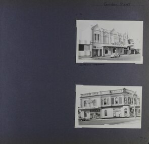
Album - Album page, Gordon Street, Circa 1972
... Architectural interest is restricted to the late Victorian facade, with its relatively unusual three bay arrangement, each topped by large triangular pediments that project beyond the parapet, providing an interesting silhouette. trevor hart glen huntly road gordon street elsternwick theatre corner shops classic cinema elsternwick theatre shops cars glenhuntly road chinese cafes Kum San restaurant P Calandro & Co Real Estate Agents Hand written: Gordon Street [top right] / CLASSIC THEATRE [under top photo] / 70[bottom right] Page 70 of Photograph Album with two portrait photographs (external views) of properties on Gordon Street Gordon Street Album Album page ...This photograph is part of the Caulfield Historical Album 1972. This album was created in approximately 1972 as part of a project by the Caulfield Historical Society to assist in identifying buildings worthy of preservation. The album is related to a Survey the Caulfield Historical Society developed in collaboration with the National Trust of Australia (Victoria) and Caulfield City Council to identify historic buildings within the City of Caulfield that warranted the protection of a National Trust Classification. Principal photographer thought to be Trevor Hart, member of Caulfield Historical Society. Most photographs were taken between 1966-1972 with a small number of photographs being older and from unknown sources. All photographs are black and white except where stated, with 386 photographs over 198 pages.From: https://vhd.heritagecouncil.vic.gov.au/places/65624 (as of 20/01/2021) National Trust listing for the Classic Cinema Property No. B7027 The Elsternwick Theatre, established in 1911 in an earlier hall, is of Regional historical and social significance. Historically, the Elsternwick Theatre is important as the longest continuously operating cinema in Victoria. However, the building itself was not purpose built as a cinema, and little remains of the early cinema interior. It is also notable as one of a handful of early cinemas in Victoria to still operate. The Elsternwick Theatre is socially significant for its association with cinema, the major form of popular entertainment in the early twentieth century. Prior to the conversion of the premises into a picture theatre in 1911, the building was an important community gathering place; as a public hall and lodge rooms. Architectural interest is restricted to the late Victorian facade, with its relatively unusual three bay arrangement, each topped by large triangular pediments that project beyond the parapet, providing an interesting silhouette.Page 70 of Photograph Album with two portrait photographs (external views) of properties on Gordon StreetHand written: Gordon Street [top right] / CLASSIC THEATRE [under top photo] / 70[bottom right] trevor hart, glen huntly road, gordon street, elsternwick, theatre, corner shops, classic cinema, elsternwick theatre, shops, cars, glenhuntly road, chinese cafes, kum san restaurant, p calandro & co real estate agents -
 Glen Eira Historical Society
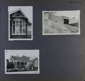
Album - Album page, Hotham Street, Circa 1972
... The survival of the riveted iron girders with their bellied angle iron struts is important since these elements are representative of the civil engineering practices of the Victorian Railways at the time and constitute the technical significance (Criterion F) of the structure. trevor hart elsternwick hotham street caulfield houses brick bay windows verandahs railway bridges tunnels gardens bluestone civil engineering victorian railways sharp and campbell contractors Handwritten: Hotham Street [top right] / 112 HOTHAM ST [under top left photo] / BRIDGE OVER SANDRINGHAM RAILWAY [under top right photo] / 112 HOTHAM ST CNR MELBY AVE [under bottom left photo] / 96 [bottom right] Page 96 of Photograph Album with three photographs (one portrait and two landscape) from Hotham Street - two external views of one house and a railway bridge. ...This photograph is part of the Caulfield Historical Album 1972. This album was created in approximately 1972 as part of a project by the Caulfield Historical Society to assist in identifying buildings worthy of preservation. The album is related to a Survey the Caulfield Historical Society developed in collaboration with the National Trust of Australia (Victoria) and Caulfield City Council to identify historic buildings within the City of Caulfield that warranted the protection of a National Trust Classification. Principal photographer thought to be Trevor Hart, member of Caulfield Historical Society. Most photographs were taken between 1966-1972 with a small number of photographs being older and from unknown sources. All photographs are black and white except where stated, with 386 photographs over 198 pages.Victorian Heritage Database - Hotham Street Road Overbridge HO116 Heritage Overlay - City of Glen Eira https://vhd.heritagecouncil.vic.gov.au/places/43557 (as of 04/07/2021) The Hotham Street road overbridge is located on the Sandringham railway line between Ripponlea and Elsternwick railway stations. It is presumed to have been built by contractors Sharp and Campbell who signed a contract on 25th . November, 1881 to construct a second line of railway between Windsor and Elsternwick. This contract was completed during 1882 and the bridge may have been designed in the year when Robert Watson took over from William Elsdon as engineer in chief for the Victorian railways. It is historically, aesthetically and technically significant. It is historically significant (Criterion A) to the extent that it demonstrates the standards of construction adopted by the Victorian Railways Department when it rebuilt the lines acquired from the private railway companies, (compare the Geelong and Melbourne Railway Co's line from Newport to Geelong, acquired in 1860). It is aesthetically significant (Criterion E) as an intact nineteenth century structure of its type, many similar girder bridges having been renewed with concrete girders in recent years. The bluestone abutments demonstrate high standards of stone masonry and are representative of Departmental work of the period. This bridge forms one of a group of historic structures on the railway to Brighton Beach and therefore contributes to the line's cultural importance as a whole. The survival of the riveted iron girders with their bellied angle iron struts is important since these elements are representative of the civil engineering practices of the Victorian Railways at the time and constitute the technical significance (Criterion F) of the structure.Page 96 of Photograph Album with three photographs (one portrait and two landscape) from Hotham Street - two external views of one house and a railway bridge.Handwritten: Hotham Street [top right] / 112 HOTHAM ST [under top left photo] / BRIDGE OVER SANDRINGHAM RAILWAY [under top right photo] / 112 HOTHAM ST CNR MELBY AVE [under bottom left photo] / 96 [bottom right]trevor hart, elsternwick, hotham street, caulfield, houses, brick, bay windows, verandahs, railway bridges, tunnels, gardens, bluestone, civil engineering, victorian railways, sharp and campbell, contractors -
 Bendigo Historical Society Inc.
Photograph - LARGE EDWARDIAN STYLE HOUSE ON CORNER BLOCK
... Street Bendigo goldfields BUILDINGS Residential Black and white photograph on embossed card. Large Edwardian? Style house on corner block. Gable roof with attic in front. Bay windows under return verandah with concrete rendered supports, decorative brick work on balustrade. Picket fence with lattice on top. Pergolas over gates. Inscriptions on front - 'Vincent Kelly, Bendigo'. On back - 'Knights/front view ...Black and white photograph on embossed card. Large Edwardian? Style house on corner block. Gable roof with attic in front. Bay windows under return verandah with concrete rendered supports, decorative brick work on balustrade. Picket fence with lattice on top. Pergolas over gates. Inscriptions on front - 'Vincent Kelly, Bendigo'. On back - 'Knights/front view', TC Watts & Son, Auctioneer, Estate Agents, Imperial Fire Office. Beehive Chambers, Pall Mall, Bendigo' (rectangular decorative stamp on back). 'Royal Historical Society of Victoria, Bendigo Branch (circular stamp).buildings, residential -
 Bendigo Historical Society Inc.
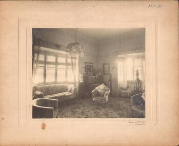
Photograph - DRAWING ROOM, c.1930
... History House 11 Mackenzie Street Bendigo goldfields PLACE drawing room See also 2001.145.01 Vincent Kelly, Bendigo Black and white photograph. Interior view of lounge / drawing room with bay window, chairs, piano and minor statuary. ...Black and white photograph. Interior view of lounge / drawing room with bay window, chairs, piano and minor statuary. Inscriptions front - 'MP91', 'Vincent Kelly, Bendigo'. On back - 'RHSV stamp', :TC Watts stamp', 'Knight's showing portion of drawing room. History: Previous Reg. No. MP91. Part of a collection of photographs used by Estate Agent TC Watt & Son, Bendigo to show potential purchasers.Vincent Kelly, Bendigoplace, drawing room, see also 2001.145.01 -
 Bendigo Historical Society Inc.
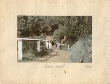
Photograph - LOVER'S WALK, COWES
... Street Bendigo goldfields PLACE A.J. Murray, Ciommercial Photographer, Photo Shop, Coses coloured photo: family group ? 3 adult females in cloche hats and overcoats, two small females on scenic walk. Path through bush and trees with white post and rail fence. On front board, handwritten ' Lovers Walk, Cowes' Won by Mr. L. Batchelder ( Bendigo Photographer's family ? ) ' Gents Rope Quoits/Bay View ...coloured photo: family group ? 3 adult females in cloche hats and overcoats, two small females on scenic walk. Path through bush and trees with white post and rail fence. On front board, handwritten ' Lovers Walk, Cowes' Won by Mr. L. Batchelder ( Bendigo Photographer's family ? ) ' Gents Rope Quoits/Bay View Cowes, Feb. 1933 'A.J. Murray, Ciommercial Photographer, Photo Shop, Cosesplace -
 The Beechworth Burke Museum
Photograph, 1960s
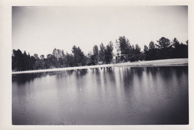
... The Beechworth Burke Museum Loch Street Beechworth high-country This photograph was taken in the 1960s at Lake Sambell and is a view across the lake from the east side, the photo was taken during a period of improvements to the lake and surrounding area. Lake Sambell is an artificial lake that was created on the site of the old Rocky Mountain Mining Company workings and was officially opened by Minister for Lands, Mr Baily, on October 5, 1928. ...This photograph was taken in the 1960s at Lake Sambell and is a view across the lake from the east side, the photo was taken during a period of improvements to the lake and surrounding area. Lake Sambell is an artificial lake that was created on the site of the old Rocky Mountain Mining Company workings and was officially opened by Minister for Lands, Mr Baily, on October 5, 1928. The disused and unattractive remains of the mine were converted into a recreational area intended for swimming, boating, and fishing. The lake is named after Mr L.H. Sambell, shire engineer and secretary of the Forward Beechworth Committee, who advocated for the enhancement of Beechworth into a tourist destination and was central to the planning and establishment of the lake. Funding for the project was raised through both competition funds and donations. Since the construction in 1928 several engineering issues have arisen. In 1939 the water levels were low, and the lake was considered both an eyesore and ‘mudhole’, Beechworth Shire Council sort funding to raise the height of the lake six feet to improve the quality of water. Throughout the 1940s the Beechworth Swimming Club sort to address the structural engineering issues and improve swimming facilities at the lake. R.E. Carter, similar to L.H. Sambell, was a shire engineer who advocated the importance of positioning Beechworth as a tourist destination. Carter held the position of shire engineer from 1954-63 and organised many improvements to the Lake Sambell area including the caravan park in 1959, the lake swimming pool in 1961, water skiing and boating facilities, and increased the lake surface area in 1964. These improvements to the lake also reflect an increase in leisure time and access to travel during a period of post-war prosperity in Australia during the 1950s and 60s. This photograph is of historical significance as it documents Lake Sambell in the 1960s after a series of enhancements to the lake area to improve its appearance and usability for both the people of Beechworth and tourists. It is also of social significance in providing an insight into the increase in leisure time and access to travel during a period of post-war prosperity. Black and white rectangle photograph printed on photographic paper and unmounted.Reverse: 3534 C798lake sambell, l.h. sambell, r.e. carter, rocky mountain mining company, forward beechworth committee, beechworth swimming club, wallace park lake sambell development scheme, lake sambell caravan park, beechworth 1960s, lake sambell swimming pool, lake sambell boating, lake sambell fishing, swimming, boating, water skiing, fishing, post-war prosperity, minister of lands, artificial lake, open cut sluice mine, lake -
 Mission to Seafarers Victoria
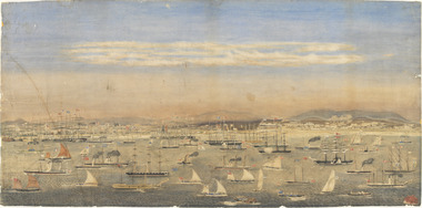
Print - Reproduction, Wilbraham Frederick Evelyn Liardet, View of the North Shore, Port of Melbourne, 1862
... Street Docklands melbourne Liardet, W. F. E. (Wilbraham Frederick Evelyn), 1799-1878 depicts the busy port of Melbourne showing many types of ships and the Bethel Church built in 1860 on the Custom House land. The church replaced the Bethel ship which sank in February 1860. This watercolour along with the Francois Cogne print from 1863, "Sandridge from Hobson's Bay, and the engraving "A Bird's-eye View ...Liardet, W. F. E. (Wilbraham Frederick Evelyn), 1799-1878 depicts the busy port of Melbourne showing many types of ships and the Bethel Church built in 1860 on the Custom House land. The church replaced the Bethel ship which sank in February 1860.This watercolour along with the Francois Cogne print from 1863, "Sandridge from Hobson's Bay, and the engraving "A Bird's-eye View Of Melbourne From Sandridge" dating from 1882, is a rare depiction fo the Bethel church. In 1887, the church was demolished to erect the building still standing on the corner of Nott Street and Beach Road.wilbraham liardet, sandridge, port, ships, port melbourne, hobsons bay, bethel church, reverend kerr johnston, 1812-1887, missions to seamen, 1862, customs house -
 Phillip Island and District Historical Society Inc.
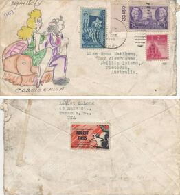
Envelope, 1946
... Addressed to: Miss Roma Matthews, "Bay View", Cowes, Phillip Island, Pictoria, Australia (the "P" was on the envelope) On the back from: August L. Long, 45 Main Street...Addressed to: Miss Roma Matthews, "Bay View", Cowes, Phillip Island, Pictoria, Australia (the "P" was on the envelope) On the back from: August L. Long, 45 Main Street ...Envelope from the USA - see Physical Description for more details.An envelope with coloured drawing on the front of a lady and man sitting on a couch - "definitely cosmorama" written under drawing. 2 x 3c and 1 x 2c US Stamps on the envelope. Addressed to: Miss Roma Matthews, "Bay View", Cowes, Phillip Island, Pictoria, Australia (the "P" was on the envelope) On the back from: August L. Long, 45 Main Street, WAnamie P.A. USA. A stamp on the back saying: "Another enemy to conquer - Forest Fires - nine out of ten can be prevented" Federal and State Forest Services. A drawing of a squirrel on the side of the stamp.As aboveenvelope from usa, k findlay -
 Phillip Island and District Historical Society Inc.
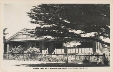
Photograph - Post Card, Early 1900's
... Views No. 21" "Marldon Guest House, Cowes, Phillip Island, Vic." On Back: "Dear Matre, We are having a nice time here. It is my birthday today and we had a cake with three candles and I got 2 ribbons and some sweeties and some hankies. Will see you on Sat. Love Lyn. Addressed to: Mrs C. Henderson,17 Woodmason Street, Malvern, Melbourne." Black & White postacrd of Marldon Guest House. Situated in an elevated position over looking bay ...One of a collection of photographs purchased by the Society from Jack Day of Mornington.Black & White postacrd of Marldon Guest House. Situated in an elevated position over looking bay in Thompson Avenue, Cowes. House has verandah with garden behind a fence and a pine tree providing shade in the street outside."Murray Views No. 21" "Marldon Guest House, Cowes, Phillip Island, Vic." On Back: "Dear Matre, We are having a nice time here. It is my birthday today and we had a cake with three candles and I got 2 ribbons and some sweeties and some hankies. Will see you on Sat. Love Lyn. Addressed to: Mrs C. Henderson,17 Woodmason Street, Malvern, Melbourne."marldon guest house, cowes, phillip island, jack day collection -
 Phillip Island and District Historical Society Inc.
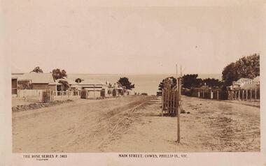
Photograph, 1911-12
... View down Main Street to Bay and newly planted Cypresses within tree guards approx 1911-1912...Bernard Grayden. 1975 local history documents postcards cowes phillip island sepia postcard cypresses Main Street, Cowes, Phillip Island, Victoria. The Rose Series P 3413 View down Main Street to Bay and newly planted Cypresses within tree guards approx 1911-1912 Photograph ...Part of collection donated to the Museum by Mr. Bernard Grayden. 1975View down Main Street to Bay and newly planted Cypresses within tree guards approx 1911-1912Main Street, Cowes, Phillip Island, Victoria. The Rose Series P 3413local history, documents, postcards, cowes, phillip island, sepia postcard, cypresses -
 Victorian Interpretive Projects Inc.
Photograph - colour, Clare Gervasoni, St Peter's Catholic Church, Daylesford, 2015, 14/06/2015
... The north side consists of a handsome entrance, near the north-west angle, approached by nine steps of cut stone, and four bays of windows on nave, and a small door on side of chancel, intended as an entry from the sacristy. The south side presents a very handsome view to Victoria street, a beautiful porch entrance giving access to the building on the south-east end of nave; and on the south-west angle a handsome octagonal spire, terminating in an iron cross, with gilt floriations; the height of top of cross, from floor line, is 88 feet. ...The north side consists of a handsome entrance, near the north-west angle, approached by nine steps of cut stone, and four bays of windows on nave, and a small door on side of chancel, intended as an entry from the sacristy. The south side presents a very handsome view to Victoria street, a beautiful porch entrance giving access to the building on the south-east end of nave; and on the south-west angle a handsome octagonal spire, terminating in an iron cross, with gilt floriations; the height of top of cross, from floor line, is 88 feet. ..."The fine structure of St. Peter's, with its prettily-decorated interior, which holds crowded congregations at Holy Mass on Sundays, is alone an eloquent testimony of the piety and devotion which permeates the whole parish. Attached to the church is a circulating library, and Catholic papers and other literature are distributed at the church door. Branches of the H.A.C.B. Society and Catholic Federation are doing much good work. (Melbourne Advocate, 17 January 1914) "OPENING AND CONSECRATION OF THE NEW CATHOLIC CHURCH OF ST. PETER’S, DAYLESFORD Cross on St. Peter'sNotwithstanding the inclemency of the weather, the opening of the new Catholic Church of St. Peter’s, yesterday (Sunday), attracted a crowded congregation. Although the rain, which has poured almost incessantly for some days past, had left our roads and streets in the condition for which Daylesford is celebrated in winter weather, and although he storm and rain seemed to increase as the hour announced for the ceremonies approached, the church was filled by a large congregation, comprising all sects and denominations of Christians in and around the district. The beautiful edifice, erected mainly through the zeal, liberality and energy of the respected pastor, presented a most imposing appearance, and reflects infinite credit upon the Rev. Mr. Slattery, and the flock committed to his charge. The church was commenced in November 1863 and has been in the hands of the workmen up to the present time, work being uninterruptedly carried on. On commencing the foundations, it was necessary to excavate until solid clay was reached, which in consequence of the deep rich chocolate soil on the site of the building, had to be carried down to an average depth of 6 feet 6 inches. The foundations were laid with massive stones in courses of 12-inch, and four feet thick, reducing to 3 feet below the floor line. The style of the building is decorated Gothic, and consists of a nave, 80 feet by 30 feet in the clear, and a chancel 18 feet high; from floor line to apex of roof, 47 feet, which is elegantly constructed, consisting of six spans or frames with puncheons resting on carved corbels, low down between the windows. The north side consists of a handsome entrance, near the north-west angle, approached by nine steps of cut stone, and four bays of windows on nave, and a small door on side of chancel, intended as an entry from the sacristy. The south side presents a very handsome view to Victoria street, a beautiful porch entrance giving access to the building on the south-east end of nave; and on the south-west angle a handsome octagonal spire, terminating in an iron cross, with gilt floriations; the height of top of cross, from floor line, is 88 feet. A stone stairs gives access to the organ gallery and the belfry. The whole of the windows are of a handsome geometrical design, and carved in stone, with mullions and tracery, and glazed with amber-tinted glass, the chancel window being 15 feet high, and 8 feet wide. The chancel arch is unusually large, 27 feet St. Peter's interiorhigh and 18 feet wide, and handsomely moulded, and presents a fine appearance from the body of the church. The roof is stained a rich oak, with heavy cornice, and all the walls are smoothly plastered, and colored peach color, giving the amber-tinted glass a beautiful soft cathedral appearance to the interior. The altar is of a very chaste design, the panels being moulded with Gothic heads, and finished in white and gold; the altar rail was not completed, but is intended to be of polished cedar, with carved pillars. The interior fittings will be proceeded with immediately, and to complete the design, an organ gallery, with sittings for about 100 persons besides the choir, will be constructed on the west end. It is intended also to place pillar gaslights on each side of the main entrance, for lighting during vespers in winter. The style of architecture has been strictly carried out, and in the best and most substantial manner. The building has been erected under the superintendence of the architect Mr. John Townsend Brophy, a member of the congregation, and who has discharged his duty with great ability and care. The hour of half-past eleven has scarcely passed when from the sacristy entered His Lordship the Right Rev. Dr. Gould, Bishop of Melbourne, preceded by the Very Rev. Dean Hayes (Sandhurst), the Rev. P. J. Slattery, and a number of boys dressed in white surplices. The Right Reverend Prelate proceeded to the foot of the altar, the Very Rev. the Dean on his right, and the Rev. P. J. Slattery on the left. The prayers usual upon the occasion were read by the Bishop. A procession was then formed, and went around the church in the following order. Several youths bearing wax candles first, next the Very Rev. the Dean, then the Bishop and his train bearers, and following were the Rev. Mr. Slattery and acolytes. Having returned to the altar in the same order, the Deacon (Dean Hayes) and Sub-Deacon (Rev. P. J. Slattery) proceeded to robe his Lordship, who had taken his seat at the epistle side of the altar, for the solemn High Mass, at appropriate times wearing his mitre and bearing his crozier. The mass, which was chanted by the Bishop with touching simplicity and earnestness, was then commenced. The choir, under the direction of Mr. Meunsch, organist, was full and most effective. Mrs. Testar, of Melbourne, having generously offered her valuable services, took the leading soprano solos, and it is scarcely necessary to add, rendered them with exquisite taste and feeling – her beautiful voice being heard with great effect throughout the entire building. The choir consisted of the following ladies and gentlemen who volunteered to aid in the ceremonies upon this most interesting occasion. Ladies: Mrs. Tresar, soprano; Mrs. J.J. McCormick, alto; Miss Julia Conry, soprano; Mrs. Vincent, soprano; Mrs. Aitken, soprano. Gentlemen: H. Guthiel, tenor; Master John Murphy, tenor; James Knox, bass; J. M. Murphy, bass; Mr. Staunton, baritone; Mr. Sourby, alto; Mr. Short, bass. The chant, “Let us adore,” during the procession, was given by Mrs. Vincent with considerable power. The selection of the “Imperial Mass” (Haydn’s No. 3) was felicitous, and the highly artistic and finished manner in which the different parts were sustained, demonstrated that great and persevering care must have been bestowed on the preparation for “the opening day.” The “Kyrie” was given with the full strength and power of the choir. The swelling of the voices in complete harmony, and the pealing of the organ in the midst of incense and prayer, produced a most marked effect upon the congregation. In the “Gloria,” the solos of Mrs. Testar were really beautiful and Mrs. McCormick rendered the alto solos with considerable merit. Mr. Knox sang the part commencing with the words “Qui tolles” with much taste and power. The “Credo” than which we believe there is not a more magnificent piece of sacred music extant, was most successful in its rendering, nor do we ever remember to have heard anything more touching than the manner in which the line “Vetam Venturi in Seculi,” was given by Mrs. Testar. The offertory hymn “Come unto Me all ye that labor,” was given by Mrs. Testar with the most thrilling effect. The “Sanctus” having been sung, in which Mr. Sourby ably rendered an alto solo, the “Agnus Dei” was commenced with a solo by Mrs. McCormick and was given with great taste and feeling, Mrs. Testar, at the conclusion of the “Agnus,” taking up the soprano part. Mass being concluded, the Very Reverend Dean Hayes ascended the altar and proceeded to preach the opening sermon, taking as his text Second Paralipomenon [Chronicles II], 7th chapter and 16th verse – “For I have chosen and have sanctified this place that My hand may be there for ever, and My eyes and My heart may remain there perpetually.” St Peter's manseAt the close of the sermon a collection was made by the very reverend preacher, assisted by John Egan, Esq., Corinella, on behalf of the church, and about fifty pounds were contributed. When it is remembered that 500 tickets had been issues at 10s each, and the inclemency of the weather taken into consideration, the collection may be regarded as a large one. Benediction was sung by the Rev. P. J. Slattery, assisted by Dean Hayes, the choir singing the “O! Salutaris Hostia” and “Laudate.” Handel’s Hallelujah Chorus was sung at the termination of the ceremonies. The vestments issued at Benediction, as well as at the Mass, were of the most gorgeous and beautiful character. When the Benediction was over, the Rev. P. J. Slattery, standing at the front of the altar said– “I wish to say one or two words before the congregation leave. I feel most deeply indebted to all of you who have attended here today for the honor and glory of God, not withstanding the difficulties you had to encounter from this most inclement season. I am truly delighted at such a manifestation of feeling, and will not easily forget it.” The rev. gentleman having disrobed, thanked the members of the choir for their kindness in assisting at the ceremonies, and more especially Mrs. Testar, who had braved all the storm and rain to be present at, and give the advantage of her great musical abilities on, the “opening day.” (Daylesford Mercury, 15 May 1865.)A number of photographs of St Peter's Catholic Church, Daylesford, taken at the 150th anniversary celebration. st peter's catholic church daylesford, decoration, altar decoration, anniversary, daylesford, religion, painting, interior, slattery, gough, d'alton, mcmahon -
 Bendigo Historical Society Inc.
Postcard - Alice McGregor Postcard Collection, 1900 - 1920
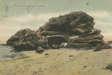
... In Victoria in 1938, Alice Mary Salter married James Thomas McGregor (born Victoria 1917, died Victoria 1983, buried Fawkner Cemetery) Lived: 1968; 22 Wade Street Golden Square Alice McGregor Died: 1999 aged 91 at Anne Caudle Centre, Bendigo Buried: Kangaroo Flat Cemetery See additional research. Postcard Album of Alice McGregor contained 86 post cards. POSTCARD Collector Alice McGregor Addressed to Miss A. Stapleton, Arcade, Bendigo Sender - G.C., Bay View ...Alice McGREGOR Born: 1908; unknown parents. Possibly adopted by the Salter family? Electoral Roll 1936: Highland Terrace Kangaroo Flat. Alice Mary Salter and William Robert Salter living together; presumed to be sister and brother. William Robert Salter was killed in a MVA in Bendigo in 1937 aged 26. In Victoria in 1938, Alice Mary Salter married James Thomas McGregor (born Victoria 1917, died Victoria 1983, buried Fawkner Cemetery) Lived: 1968; 22 Wade Street Golden Square Alice McGregor Died: 1999 aged 91 at Anne Caudle Centre, Bendigo Buried: Kangaroo Flat Cemetery See additional research. Postcard Album of Alice McGregor contained 86 post cards.Postcard Album of Alice McGregor containing 86 postcards. See 1400 Colour photo of The London Bridge, Sorrento, Victoria Rock structure at the water's edge. Tunnel through the rock showing several people emerging. Addressed to Miss A. Stapleton, Arcade, Bendigo Sender - G.C., Bay View Cottage, Sorrento Dated 12.1.06 postcard, collector, alice mcgregor -
 Bendigo Historical Society Inc.
Postcard - GLADYS DEAN COLLECTION: POSTCARD, 1906 - 1908
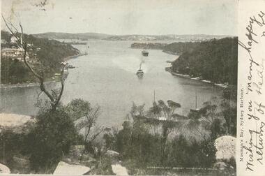
... History House 11 Mackenzie Street Bendigo goldfields POSTCARD Symbol - artist palette and letters HB Coloured photographic postcard. Image has a 1.7cm white border on the right hand side and depicts Mossmans Bay Sydney NSW. The image shows a view ...Coloured photographic postcard. Image has a 1.7cm white border on the right hand side and depicts Mossmans Bay Sydney NSW. The image shows a view of the bay taken from height, several boats can be seen in the bay and houses are on the left hand shore and in the distance. The words Mossmans Bay Sydney Harbour N.S. Wales are printed in white in the lower right hand corner of the image. On the border, the words Mosman's Bay Sydney Harbour are printed in black and the words Wishing you many happy returns of the day are handwritten there also. On reverse it is addressed to Miss Dean McKenzie St Golden Square. A black and white image of palms appear on the left hand side with the words NSW Bangalore Palms in white along the bottom. A one penny stamp is affixed postmarked Bendigo. A symbol of an artists palette with the letters HB is along the top.Symbol - artist palette and letters HBpostcard -
 Bendigo Historical Society Inc.
Postcard - Alice McGregor Postcard Collection, 1900 - 1920
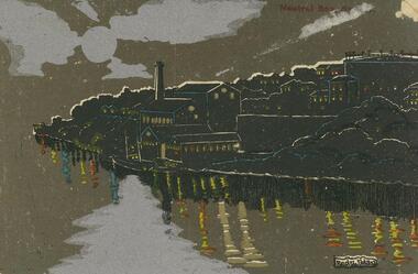
... Street Golden Square Alice McGregor Died: 1999 aged 91 at Anne Caudle Centre, Bendigo Buried: Kangaroo Flat Cemetery See additional research. Postcard Album of Alice McGregor contained 86 post cards. POSTCARD Collector Alice McGregor Addressee - Miss H.F. Shatford, Black Rock, Sandringham Sender - V.H.Davies, Kanya, 'Mount View Not Dated Postcard Album of Alice McGregor containing 86 postcards. See 1400 A black, silver and brown picture of Neutral Bay ...Alice McGREGOR Born: 1908; unknown parents. Possibly adopted by the Salter family? Electoral Roll 1936: Highland Terrace Kangaroo Flat. Alice Mary Salter and William Robert Salter living together; presumed to be sister and brother. William Robert Salter was killed in a MVA in Bendigo in 1937 aged 26. In Victoria in 1938, Alice Mary Salter married James Thomas McGregor (born Victoria 1917, died Victoria 1983, buried Fawkner Cemetery) Lived: 1968; 22 Wade Street Golden Square Alice McGregor Died: 1999 aged 91 at Anne Caudle Centre, Bendigo Buried: Kangaroo Flat Cemetery See additional research. Postcard Album of Alice McGregor contained 86 post cards.Postcard Album of Alice McGregor containing 86 postcards. See 1400 A black, silver and brown picture of Neutral Bay, Sydney at night. Houses and factory on a headland with a 2 masted boat in the water. Reflections on the water. Artist - Redzi NolanAddressee - Miss H.F. Shatford, Black Rock, Sandringham Sender - V.H.Davies, Kanya, 'Mount View Not Dated postcard, collector, alice mcgregor -
 Bendigo Historical Society Inc.
Photograph - BENDIGO VIEWS COLLECTION: PALL MALL, 1940's
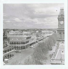
... Street Bendigo goldfields PHOTOGRAPH Streetscape Bendigo's Pall Mall Photograph. Tree lined Pall Mall on the north side, as is the post Office clockand roof of the Law courts. Cars in parking bays on other side. Shamrock Hotel left of photo and a double story building on Williamson Street corner, Myers store next to it. Maples store is in back ground. Photograph BENDIGO VIEWS ...Photograph. Tree lined Pall Mall on the north side, as is the post Office clockand roof of the Law courts. Cars in parking bays on other side. Shamrock Hotel left of photo and a double story building on Williamson Street corner, Myers store next to it. Maples store is in back ground.photograph, streetscape, bendigo's pall mall -
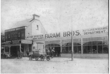 Port Melbourne Historical & Preservation Society
Photograph - 405 Bay Street (Faram Bros), Port Melbourne, 1920
... 1920s view of 405 Bay Street shortly after purchase by the Faram Bros Thomas and Richard. ...Port Melbourne Historical & Preservation Society Port Melbourne Town Hall 333 Bay Street Port Melbourne melbourne Built Environment - Commercial Business and Traders - Hardware Faram Brothers Hardware Judy FARAM 1920s view of 405 Bay Street shortly after purchase by the Faram Bros Thomas and Richard. ...1920s view of 405 Bay Street shortly after purchase by the Faram Bros Thomas and Richard. (Appears to have been photographically printed on part of a postcard form) Shows new verandah added by Faram Bros.built environment - commercial, business and traders - hardware, faram brothers hardware, judy faram -
Port Melbourne Historical & Preservation Society
Photograph - Aerial view, Fishermen's Bend, 1947
... Port Melbourne Historical & Preservation Society Port Melbourne Town Hall 333 Bay Street Port Melbourne melbourne fishermans bend footscray Aerial photo of Fishermen's Bend with Footscray in foreground, Maribyrnong River and varous airfields upper left. c1947 Photograph Aerial view, Fishermen's Bend ...Aerial photo of Fishermen's Bend with Footscray in foreground, Maribyrnong River and varous airfields upper left. c1947fishermans bend, footscray -
Port Melbourne Historical & Preservation Society
Photograph - Aerial view Maribyrnong and Yarra rivers and Coode Island, c. 1976
... Bay Street Port Melbourne melbourne Donated to City of Port Melbourne by Councillor Russell GRIFFITHS. Transport - Shipping Piers and Wharves - Miscellaneous Swanson Dock Aerial photograph taken from above junction of Yarra and Maribyrnong rivers showing oil and chemical storage farm at Coode Island and four container vessels at Swanson Dock. Photograph Aerial view ...Donated to City of Port Melbourne by Councillor Russell GRIFFITHS.Aerial photograph taken from above junction of Yarra and Maribyrnong rivers showing oil and chemical storage farm at Coode Island and four container vessels at Swanson Dock.transport - shipping, piers and wharves - miscellaneous, swanson dock -
Port Melbourne Historical & Preservation Society
Photograph - Railway Pier, Sandridge, 1880
... Port Melbourne Historical & Preservation Society Port Melbourne Town Hall 333 Bay Street Port Melbourne melbourne piers and wharves - railway pier View of Sandridge Railway Pier, c. 1880 - Printed, sepia colour Photograph Railway Pier, Sandridge ...View of Sandridge Railway Pier, c. 1880 - Printed, sepia colourpiers and wharves - railway pier -
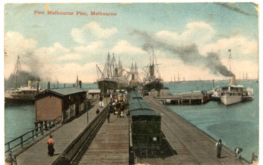 Port Melbourne Historical & Preservation Society
Postcard - Railway Pier, Port Melbourne, 1914
... Port Melbourne Historical & Preservation Society Port Melbourne Town Hall 333 Bay Street Port Melbourne melbourne Collected by Alison Kelly when she was caretaking the Missions to Seamen Building 1987-90. piers and wharves - railway pier One of six postcards, mostly various angles and times of Railway Pier, Port Melbourne. Hand Coloured postcard - Railway Pier viewed ...Collected by Alison Kelly when she was caretaking the Missions to Seamen Building 1987-90.One of six postcards, mostly various angles and times of Railway Pier, Port Melbourne. Hand Coloured postcard - Railway Pier viewed out into Bay. Three vessels at pier, two paddle steamers, train in foreground and ships in Bay.piers and wharves - railway pier -
Port Melbourne Historical & Preservation Society
Postcard - Railway Pier, Port Melbourne, 1914
... Port Melbourne Historical & Preservation Society Port Melbourne Town Hall 333 Bay Street Port Melbourne melbourne Collected by Alison Kelly when she was caretaking the Missions to Seamen Building 1987-90. piers and wharves - railway pier One of six postcards, mostly various angles and times of Railway Pier, Port Melbourne. Hand tinted view ...Collected by Alison Kelly when she was caretaking the Missions to Seamen Building 1987-90.One of six postcards, mostly various angles and times of Railway Pier, Port Melbourne. Hand tinted view of east side of Railway Pier, two steamers, one paddlesteamer and train at right.piers and wharves - railway pier -
Port Melbourne Historical & Preservation Society
Postcard - Railway Pier, Port Melbourne, 1914
... Port Melbourne Historical & Preservation Society Port Melbourne Town Hall 333 Bay Street Port Melbourne melbourne Collected by Alison Kelly when she was caretaking the Missions to Seamen Building 1987-90. piers and wharves - railway pier One of six postcards, mostly various angles and times of Railway Pier, Port Melbourne. B&W postcard - Railway Pier viewed ...Collected by Alison Kelly when she was caretaking the Missions to Seamen Building 1987-90.One of six postcards, mostly various angles and times of Railway Pier, Port Melbourne. B&W postcard - Railway Pier viewed toward shore - Three steamers and one sailing ship, train central and crowd. Full postcard size image.piers and wharves - railway pier -
Port Melbourne Historical & Preservation Society
Postcard - Railway Pier, Port Melbourne, 1914
... Port Melbourne Historical & Preservation Society Port Melbourne Town Hall 333 Bay Street Port Melbourne melbourne Collected by Alison Kelly when she was caretaking the Missions to Seamen Building 1987-90. piers and wharves - railway pier One of six postcards, mostly various angles and times of Railway Pier, Port Melbourne. B&W postcard - Railway Pier viewed ...Collected by Alison Kelly when she was caretaking the Missions to Seamen Building 1987-90.One of six postcards, mostly various angles and times of Railway Pier, Port Melbourne. B&W postcard - Railway Pier viewed toward shore - Three steamers and one sailing ship, train central and crowd. Same view as 295.03 but in sepia, reduced and within embossed area.piers and wharves - railway pier -
Port Melbourne Historical & Preservation Society
Postcard - Railway Pier, Port Melbourne, 1914
... Port Melbourne Historical & Preservation Society Port Melbourne Town Hall 333 Bay Street Port Melbourne melbourne Collected by Alison Kelly when she was caretaking the Missions to Seamen Building 1987-90. piers and wharves - railway pier One of six postcards, mostly various angles and times of Railway Pier, Port Melbourne. B&W postcard - Viewed ...Collected by Alison Kelly when she was caretaking the Missions to Seamen Building 1987-90.One of six postcards, mostly various angles and times of Railway Pier, Port Melbourne. B&W postcard - Viewed to Bay - three vessels alongside. Handwritten on right hand side - "With Best Wishes for a Merry Xmas - L. Stre-" (?- illegible)piers and wharves - railway pier