Showing 17 items matching "bayside highway"
-
 Marysville & District Historical Society
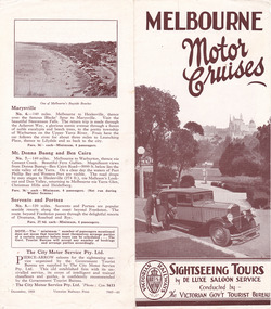
Ephemera (item) - Tourism brochure, Victorian Railways, MELBOURNE Motor Cruises, 12-1933
... ...bayside highway...A brochure outlining various sightseeing tours of Melbourne and the surrounding environments. marysville victoria australia melbourne motor cruises victorian government tourist bureau melbourne dandenong ranges warrandyte yarra river bayside highway frankston black spur narbethong mt donna buang ben cairn sorrento portsea the city motor service pty. ltd. victorian railways print A brochure outlining various sightseeing tours of Melbourne and the surrounding environments. ...A brochure outlining various sightseeing tours of Melbourne and the surrounding environments. The tours outlined include Melbourne's sights and suburbs, the Dandenong Ranges, Mount Donna Buang and Marysville. The brochure was produced by Victorian Railways Print in December 1933.A brochure outlining various sightseeing tours of Melbourne and the surrounding environments.marysville, victoria, australia, melbourne motor cruises, victorian government tourist bureau, melbourne, dandenong ranges, warrandyte, yarra river, bayside highway, frankston, black spur, narbethong, mt donna buang, ben cairn, sorrento, portsea, the city motor service pty. ltd., victorian railways print -
 Glen Eira Historical Society
Photograph - Elsternwick
... BAYSIDE WEEKLY 03/11/2010 giving snap shots of Elsternwick housing and facts. Batters Philippe Real Estate Agents Elsternwick Paddocks Glen Huntly Road Walter Kelly Elsternwick Park Slaughter yards Glen Eira roads Point Ormond Glenhuntly Railway Station Nepean Highway Grange Road Holdsworth’s Jewellers Staniland Grove Coles store Shops Orrong Road Fosseys Hattams Mensware Woolworths Dalgarnos Crockery and Kitchenware Chapmans Gifts Garth’s Shoe Store Garth Jack Allen’s Furniture and Auction Rooms Elsternwick Market Adam’s Cakes Mr. ...This file contains three items. Photocopied and three page retyped article, undated c.1930s and source unknown from Real Estate Agent Philippe Batters 03/09/1997. Three page document from Keith James Smith, undated, on research on Elsternwick and Glen Huntly Road shops and traders. Three articles from THE AGE 13/05/2000 and 15-16/02/2013 and MELB BAYSIDE WEEKLY 03/11/2010 giving snap shots of Elsternwick housing and facts.batters philippe, real estate agents, elsternwick, paddocks, glen huntly road, walter kelly, elsternwick park, slaughter yards, glen eira roads, point ormond, glenhuntly railway station, nepean highway, grange road, holdsworth’s jewellers, staniland grove, coles store, shops, orrong road, fosseys, hattams mensware, woolworths, dalgarnos crockery and kitchenware, chapmans gifts, garth’s shoe store, garth jack, allen’s furniture and auction rooms, elsternwick market, adam’s cakes, mr. green’s pet shop, turner mr., grocer shop, moores lendring library, hopetown gardens, gardens, jack hatheralls butchershop, butchers, chinese laundry, chinese community, laundries, mr. & mrs. darbyshires milkbar, st. johns church, kooyong road, hasseles garage, garages, royal parade, glenhuntly, camden, hawthorn road, blacksmiths, camden town, dolls hospital, caulfield state school 773, independent picture, theatres, camden theatre, southern indoor bowl centre, larch street, montessorie school, collins milk bar, milk bars, collins lin, hartrick miss, armond mr., lennie mr., rothells sausage factory, north road, red bus service transport, furlonger miss, dance studio, moran and cato grocery, cato family, newsagent, tozer brook, furniture store, green gables american style soda fountain and milk bar, hoyts renown theatre, state savings bank, riddell parade, clarence street, aileen avenue, smith keith james, camden town, sports club, peer gary, gary peer & associates, brukarz jack, ray white real estate, real estate agents, classic cinema theatres, st. george’s road, elizabeth street, allison road, gladstone park, myrtle street, victoria street, caulfield, st kilda east, lisbon house, orrong road, house names, rippon lea estate, caulfield south, carnegie, gordon street, carre street, main street, clarence street, elsternwick club, jewish holocaust museum, daily planet, brothels, wesley college, elsternwick primary, st. joseph’s primary, scholem aleichen college, liebler yavneh, hopetoun gardens, harleston park -
Glen Eira Historical Society
Map - Orienteering
... Bayside Kangaroos Orienteering... Bentleigh East... Sedunary Vic... Leicester Paul... Sheahan Jenny... Clubs... Sheahan John... Tamblyn Greg... Centre Road Bentleigh... Tucker Road Bentleigh... South Road Moorabbin... Associations... Nepean Highway...Bayside Kangaroos Orienteering Bentleigh East Sedunary Vic Leicester Paul Sheahan Jenny Clubs Sheahan John Tamblyn Greg Centre Road Bentleigh Tucker Road Bentleigh South Road Moorabbin Associations Nepean Highway Bentleigh RSL Club Orienteering Sports Recreations Map Orienteering ...This file contains one item. A map/plan of the Bentleigh East Running Roulette for the Monday series on 21/03/2011.bayside kangaroos orienteering, bentleigh east, sedunary vic, leicester paul, sheahan jenny, clubs, sheahan john, tamblyn greg, centre road bentleigh, tucker road bentleigh, south road moorabbin, associations, nepean highway, bentleigh rsl club, orienteering, sports, recreations -
 City of Moorabbin Historical Society (Operating the Box Cottage Museum)
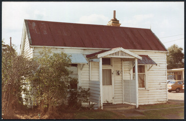
Photographs,x3 Colour Early Weatherboard Cottage Cheltenham c1880, 1981
... Highway. Notable settlers who moved into the area were Keys, Charman, Bruton, Le Page, Fairlam, Meeres and 1862 saw the separation from Brighton and the formation of the Mooorabbin Roads Board District. .By 1879 1000settlers were living in 'Cheltenham' serviced by a Post Office with Bank, Mechanics Institute, State School No 84,Keys Hotel, Meeres Store, Sir Thomas Bent ensured the new Railway Line from Caulfield to Mordialloc went through his constituency of Cheltenham 1881 and this changed the development to the bayside area of Cheltenham away from the 'Two Acre Village ' side causing some dissention, However Cheltenham as whole prospered and this house in Pine St is typical of the cottages built c 1890- 1900 in the area. ...Highway. Notable settlers who moved into the area were Keys, Charman, Bruton, Le Page, Fairlam, Meeres and 1862 saw the separation from Brighton and the formation of the Mooorabbin Roads Board District. .By 1879 1000settlers were living in 'Cheltenham' serviced by a Post Office with Bank, Mechanics Institute, State School No 84,Keys Hotel, Meeres Store, Sir Thomas Bent ensured the new Railway Line from Caulfield to Mordialloc went through his constituency of Cheltenham 1881 and this changed the development to the bayside area of Cheltenham away from the 'Two Acre Village ' side causing some dissention, However Cheltenham as whole prospered and this house in Pine St is typical of the cottages built c 1890- 1900 in the area. ...Henry Dendy , a farmer from Sussex England, purchased 5,120 acres of land in the area of a 'Special Survey 1841' that extended from Brighton bayside North Road, East Boundary Rd to South Road. This area became known as Dendy's Brighton and as part of the sale 139 emigrant workers arrived in 1842 however Dendy was unable to find work and lodgings for these people. J.B.Were, financier took over the management of the 'Special Survey 1841' area and began to sell and lease allotments. 1850 the Squatter King brothers sold land south of Dendy's 'Special Survey 1841' to Josiah Holloway who sectioned it into 2 acre lots @ £10 each for market gardens - 'Two Acre Village' and Charles Whorral opened a small hotel - 'The Cheltenham Inn' on the main Road - Arthur's Seat Rd, later Point Nepean Rd, now Nepean Highway. Notable settlers who moved into the area were Keys, Charman, Bruton, Le Page, Fairlam, Meeres and 1862 saw the separation from Brighton and the formation of the Mooorabbin Roads Board District. .By 1879 1000settlers were living in 'Cheltenham' serviced by a Post Office with Bank, Mechanics Institute, State School No 84,Keys Hotel, Meeres Store, Sir Thomas Bent ensured the new Railway Line from Caulfield to Mordialloc went through his constituency of Cheltenham 1881 and this changed the development to the bayside area of Cheltenham away from the 'Two Acre Village ' side causing some dissention, However Cheltenham as whole prospered and this house in Pine St is typical of the cottages built c 1890- 1900 in the area. This weatherboard house c 1890-1900 in Pine St Cheltenham is typical of those built for early settler families. Photo taken 1981 by CMHS member 3 x Colour photographs of an early c 1900 weatherboard house in Pine St Cheltenham taken by CMHS member 1981Kodak Aug. 81 / Handwritten Pine St Cheltenhamkeys robert, holloway josiah, king brothers, smith j l; smith mary ann, stanley helen, chaff cutter, horse drawn carts, toll gates brighton, motor cars 1900, steam engines, early settlers, bentleigh, parish of moorabbin, city of moorabbin, county of bourke, moorabbin roads board, shire of moorabbin, henry dendy's special survey 1841, were j.b.; bent thomas, o'shannassy john, king richard, charman stephen, highett william, ormond francis, maynard dennis, market gardeners, vineyards, orchards -
 City of Moorabbin Historical Society (Operating the Box Cottage Museum)
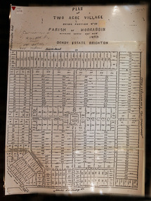
Document,photocopy plan 'Two Acre Village 'c1852, c1960
... Cheltenham became a very important part of the large Moorabbin Shire1871 and City of Moorabbin 1934 In the 1994 Amalgamation of Councils, when the large City of Moorabbin was divided between the newly formed Glen Eira, Kingston and Bayside Councils, the Cheltenham area was assigned to the City of Kingston moorabbin brighton cheltenham market gardeners pioneers early settlers , king. John, Holloway Josiah, whorral charles, arthur’s seat road, nepean highway , Cheltenham inn hotel, henry dendy special survey 1841 A photocopy of the Plan for the 2 Acre Village in Moorabbin Parish c1852. ...In the 1852 Josiah Holloway, a developer, purchased 625 acres from the squatters Richard and John King and sectioned '2 acre allotments' south of Henry Dendy's Brighton Survey along the Arthur's Seat Road ( later Nepean Highway) for sale @ £10 It became known as The Two Acre Village as settlers took up the allotments and established market gardens, general stores, butchers, blacksmiths, post office and 2 hotels. Charles Whorral opened The Cheltenham Inn and it became so popular as a meeting place that the area was called Cheltenham. The early settlers, who were predominantly English and Scottish immigrants initially leased their allotments and, because the sandy soil was so fertile, they were soon able to purchase the land and increase their acreage. Cheltenham became a very important part of the large Moorabbin Shire1871 and City of Moorabbin 1934 In the 1994 Amalgamation of Councils, when the large City of Moorabbin was divided between the newly formed Glen Eira, Kingston and Bayside Councils, the Cheltenham area was assigned to the City of Kingston A photocopy of the Plan for the 2 Acre Village in Moorabbin Parish c1852. A3 laminatedmoorabbin, brighton, cheltenham, market gardeners, pioneers, early settlers, , king. john, holloway josiah, whorral charles, arthur’s seat road, nepean highway , cheltenham inn hotel, henry dendy special survey 1841 -
 City of Moorabbin Historical Society (Operating the Box Cottage Museum)
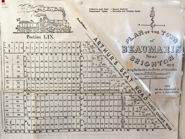
Document, photocopy of Plan of Beaumaris 1853, c1960
... Beaumaris is a suburb in Melbourne, Victoria, Australia, 19 km south-east from Melbourne's central business district. .Since the Amalgamation of Councils 1994 the local government area is the City of Bayside which includes Brighton. moorabbin county of bourke brighton beaumaris pioneers early settlers. market gardeners cheltenham king. John, Holloway Josiah, whorral charles, arthur’s seat road, nepean highway, morabbin district roads board, sandringham, mordialloc, mentone A Photocopy of the Plan of Beaumaris 1853 A3 Document, photocopy of Plan of Beaumaris 1853 CMHS member ...Beaumaris includes two early estates in the parish of Moorabbin developed by Josiah Holloway from 1852. Named Beaumaris Town and Beaumaris Estate (after the pastoral run in the area and ultimately after Beaumaris in Wales), the lots comprising them were marketed by Mr Holloway's suggesting that the railway was imminent and a canal would be built. The township developed slowly, a Post Office opened on 1 March 1868, but was replaced next month by Gipsy Village office (now Sandringham) In 1862 Beaumaris was one of the early settler communities within the boundaries of the Moorabbin District Roads Board , the region’s first local government authority. Beaumaris is a suburb in Melbourne, Victoria, Australia, 19 km south-east from Melbourne's central business district. .Since the Amalgamation of Councils 1994 the local government area is the City of Bayside which includes Brighton. A Photocopy of the Plan of Beaumaris 1853 A3moorabbin, county of bourke, brighton, beaumaris, pioneers, early settlers. market gardeners, cheltenham, king. john, holloway josiah, whorral charles, arthur’s seat road, nepean highway, morabbin district roads board, sandringham, mordialloc, mentone -
 Brighton Historical Society
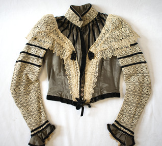
Bodice, circa 1900
... Brighton Historical Society First Floor Bayside Arts and Cultural Centre (Old Brighton Town Hall) Corner Carpenter and Wilson Streets Brighton melbourne This bodice, which originally had a matching skirt, belonged to Phoebe Richardson (nee Brinsmead, 1885-1956), who married Charles William Richardson in 1911. The family lived in Geelong. Brinsmead Lane, off the Bellarine Highway ...This bodice, which originally had a matching skirt, belonged to Phoebe Richardson (nee Brinsmead, 1885-1956), who married Charles William Richardson in 1911. The family lived in Geelong. Brinsmead Lane, off the Bellarine Highway in Leopold, is named after Phoebe's family, being the original location of the family home. The bodice was likely made by a seamstress as the family were quite fashion-conscious. Phoebe's daughter Edna Baker (nee Richardson, b. 1914) wore this bodice as a dress-up as a child. She donated it BHS in the 1980s and provided additional information on it when visiting the Society in 2004.Khaki green silk bodice, boned around waist. Ecru cotton lace overlay on sleeves and high neck. More lace over shoulders, gathered and tapered down front of bodice. Stripes of velvet ribbon around yoke. Four more stripes of velvet ribbon around upper sleeve, and three around each cuff. Velvet bows and metal buckle at waist. Tape at waist with hooks to attach to skirt. Lined with brown fabric. 20 mother-of-pearl buttons down front.phoebe richardson, phoebe brinsmead, edna baker, 1900s -
 Bayside Gallery - Bayside City Council Art & Heritage Collection
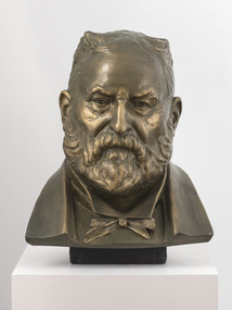
Sculpture, Margaret Baskerville, Sir Thomas Bent, c. 1911
... Bayside Gallery - Bayside City Council Art & Heritage Collection Corner Wilson and Carpenter Streets Brighton melbourne This work is a plaster maquette of a large bronze statue of politician and land speculator Sir Thomas Bent by Margaret Baskerville that is located on the corner of Bay Street and Nepean Highway, Brighton. thomas bent politician mayor premier bust sculpture margaret baskerville land speculator speaker local government councillor member of lower house portrait patinated plaster Sir Thomas Bent Sculpture sculpture Margaret Baskerville ...This work is a plaster maquette of a large bronze statue of politician and land speculator Sir Thomas Bent by Margaret Baskerville that is located on the corner of Bay Street and Nepean Highway, Brighton.Margaret Baskerville, Sir Thomas Bent c.1911, patinated plaster, 55 x 49 x 49 cm. Bayside City Council Art and Heritage Collection. Donated by Charles Douglas Richardson, 1931.patinated plaster thomas bent, politician, mayor, premier, bust, sculpture, margaret baskerville, land speculator, speaker, local government, councillor, member of lower house, portrait -
 Bayside Gallery - Bayside City Council Art & Heritage Collection
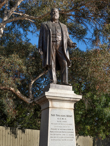
Sculpture, Margaret Baskerville, Sir Thomas Bent, 1913
... Bayside Gallery - Bayside City Council Art & Heritage Collection Corner Wilson and Carpenter Streets Brighton melbourne Arguably Margaret Baskerville’s most famous work, the bronze statue of politician and land speculator Sir Thomas Bent was Baskerville’s first public commission and a significant turning point in her career. Originally located in the centre of the Nepean Highway ...Arguably Margaret Baskerville’s most famous work, the bronze statue of politician and land speculator Sir Thomas Bent was Baskerville’s first public commission and a significant turning point in her career. Originally located in the centre of the Nepean Highway, in Brighton, it became somewhat of signpost for many Melbournians until it was relocated to the corner of Bay Street in 1980.The statue of Sir Thomas Bent is of historic and social significance to the State of Victoria. The statue is historically significant for commemorating Bent's long, active and infamous political career in Victoria. He was responsible for many important speculative ventures both within his electorate and in the wider context of Victoria. Although not without thought for personal gain, Bent was a committed advocate of public utilities, railways, roads, tramways and gasworks. The statue is historically significant as the first large public commission given to a woman sculptor in Victoria. This work helped the sculptor, Margaret Baskerville, preserve her name as Victoria's first professional woman sculptor. The statue is socially significant as testimony to the late nineteenth century land boom and the financial and political corruption and scandals that accompanied it. https://vhd.heritagecouncil.vic.gov.au/places/12614bronze and granite thomas bent, politician, mayor, premier, bust, sculpture, margaret baskerville, speaker, member of parliament, member of lower house, local government, councillor, brighton, public art, bayside -
 Bayside Gallery - Bayside City Council Art & Heritage Collection
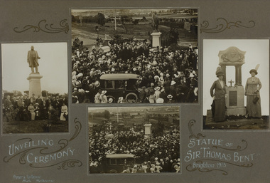
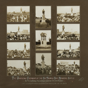
Photograph - gelatin silver photograph, Frazer & Vallance, Unveiling Ceremony, Statue of Sir Thomas Bent, Brighton, 1913
... bayside...thomas bent...unveiling...ceremony...mayoress...sculptor...councillor wilson...crowd...1913...nepean highway...Bayside Gallery - Bayside City Council Art & Heritage Collection Corner Wilson and Carpenter Streets Brighton melbourne politician mayor premier bust sculpture margaret baskerville speaker member of parliament member of lower house local government councillor brighton public art bayside thomas bent unveiling ceremony mayoress sculptor councillor wilson crowd 1913 nepean highway mrs bent elizabeth bleazby fountain memorial Compilation of four gelatin silver photographs recording the unveiling ceremony for statue of Sir Thomas Bent, Brighton, 1913. ...politician, mayor, premier, bust, sculpture, margaret baskerville, speaker, member of parliament, member of lower house, local government, councillor, brighton, public art, bayside, thomas bent, unveiling, ceremony, mayoress, sculptor, councillor wilson, crowd, 1913, nepean highway, mrs bent, elizabeth bleazby, fountain, memorial -
 Bayside Gallery - Bayside City Council Art & Heritage Collection
Photograph - gelatin silver photograph, R. McGeehan, Unveiling Ceremony of the Sir Thomas Bent Memorial Statue, 1913
... bayside...thomas bent...unveiling...ceremony...mayoress...sculptor...councillor wilson...crowd...1913...nepean highway...Bayside Gallery - Bayside City Council Art & Heritage Collection Corner Wilson and Carpenter Streets Brighton melbourne politician mayor premier bust sculpture margaret baskerville speaker member of parliament member of lower house local government councillor brighton public art bayside thomas bent unveiling ceremony mayoress sculptor councillor wilson crowd 1913 nepean highway mrs bent elizabeth bleazby fountain memorial John Madden Lieutenant Governor Compilation of eleven gelatin silver photographs recording the unveiling ceremony for statue of Sir Thomas Bent and the drinking fountain in memory of the Late Mrs Bent, by His Excellency, the Lieutenant Governor, Sir John Madden, 27 October 1913. ...politician, mayor, premier, bust, sculpture, margaret baskerville, speaker, member of parliament, member of lower house, local government, councillor, brighton, public art, bayside, thomas bent, unveiling, ceremony, mayoress, sculptor, councillor wilson, crowd, 1913, nepean highway, mrs bent, elizabeth bleazby, fountain, memorial, john madden, lieutenant governor -
 Bayside Gallery - Bayside City Council Art & Heritage Collection
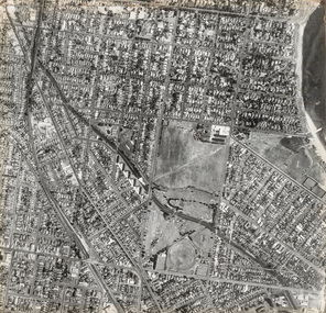
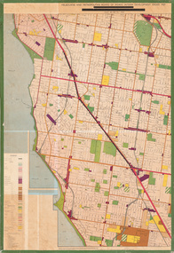
Photograph, Department of Crown Lands and Survey, Victoria, Brighton, Elwood and Elsternwick, c. 1965-71
... Bayside...Port Phillip Bay...Map...cartographic material...Elwood...Elsternwick...Elsternwick Park...Elwood Tram Depot...Elwood Pier...New Street...Glen Huntly Road...St Kilda Street...Nepean Highway...Brighton Department of Crown Lands and Survey Aerial photograph Bayside Port Phillip Bay Map cartographic material Elwood Elsternwick Elsternwick Park Elwood Tram Depot Elwood Pier New Street Glen Huntly Road St Kilda Street Nepean Highway Black and white photograph. ...The Department of Crown Lands and Survey (1857-1983) was responsible for the administration of survey and mapping and the sale, occupation and management of crown land throughout its existence. This aerial photograph shows parts of Brighton, Elwood and Elsternwick and was taken circa 1965-71.brighton, department of crown lands and survey, aerial photograph, bayside, port phillip bay, map, cartographic material, elwood, elsternwick, elsternwick park, elwood tram depot, elwood pier, new street, glen huntly road, st kilda street, nepean highway -
 Bayside Gallery - Bayside City Council Art & Heritage Collection
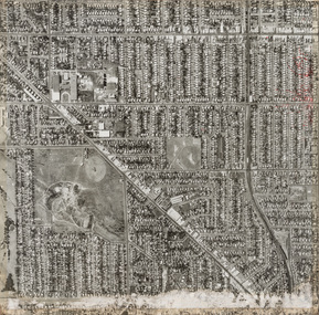
Photograph, Department of Crown Lands and Survey, Victoria, Brighton, Brighton East and Bentleigh, c. 1965-71
... Bayside...Port Phillip Bay...Map...cartographic material...Bentleigh...Brighton East...Dendy Park...Dendy Street...Centre Road...nepean highway...Brighton Department of Crown Lands and Survey Aerial photograph Bayside Port Phillip Bay Map cartographic material Bentleigh Brighton East Dendy Park Dendy Street Centre Road nepean highway South Road Football Black and white photograph. ...The Department of Crown Lands and Survey (1857-1983) was responsible for the administration of survey and mapping and the sale, occupation and management of crown land throughout its existence. This aerial photograph shows parts of Brighton, Brighton East and Bentleigh and was taken circa 1965-71.brighton, department of crown lands and survey, aerial photograph, bayside, port phillip bay, map, cartographic material, bentleigh, brighton east, dendy park, dendy street, centre road, nepean highway, south road, football -
 Bayside Gallery - Bayside City Council Art & Heritage Collection
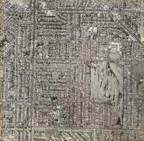
Photograph, Department of Crown Lands and Survey, Victoria, Brighton, Brighton East and Bentleigh, c. 1965-71
... Bayside...Port Phillip Bay...Map...cartographic material...Brighton East...Dendy Park...Dendy Street...Centre Road...nepean highway...Brighton Department of Crown Lands and Survey Aerial photograph Bayside Port Phillip Bay Map cartographic material Brighton East Dendy Park Dendy Street Centre Road nepean highway South Road Brighton Golf Course Golf Black and white photograph. ...The Department of Crown Lands and Survey (1857-1983) was responsible for the administration of survey and mapping and the sale, occupation and management of crown land throughout its existence. This aerial photograph shows parts of Brighton and Brighton East and was taken circa 1965-71.brighton, department of crown lands and survey, aerial photograph, bayside, port phillip bay, map, cartographic material, brighton east, dendy park, dendy street, centre road, nepean highway, south road, brighton golf course, golf -
 Bayside Gallery - Bayside City Council Art & Heritage Collection
Map - print, Melbourne and Metropolitan Board of Works, Interim development order: Brighton, Moorabbin and Sandringham, 1959
... Bayside Gallery - Bayside City Council Art & Heritage Collection Corner Wilson and Carpenter Streets Brighton melbourne The Melbourne and Metropolitan Board of Works (now Melbourne Water) was established in 1891. From that time, as part of their work laying water and sewerage connections, they created detailed plans of houses and other buildings in the Melbourne metropolitan area. In 1956 it acquired powers to construct and maintain highways ...The Melbourne and Metropolitan Board of Works (now Melbourne Water) was established in 1891. From that time, as part of their work laying water and sewerage connections, they created detailed plans of houses and other buildings in the Melbourne metropolitan area. In 1956 it acquired powers to construct and maintain highways and bridges, protect and improve the foreshores and create and maintain parks within the metropolitan region. This Interim development order comprises part of the municipalities of Brighton, Moorabbin and Sandringham and was made on 20 October 1959.brighton, moorabbin, sandringham, melbourne and metropolitan board of works, map, town planning, cartographic material, interim development order, bayside -
 Melbourne Tram Museum
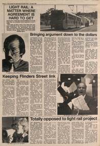
Newspaper, The Emerald Hill, Sandridge and St Kilda Times, "Light Rail: A matter where agreement is hard to get", 23/04/1987 12:00:00 AM
... Ed Dotson, Mr Patrick O'Connor Public Transport Users Association about the keeping of the Flinders St link and Mr Noel Willis, the President of the Bayside Public Transport Association who was opposed. Has photos of each of the people involved and a B class tram on route 75 in the Burwood Highway....Ed Dotson, Mr Patrick O'Connor Public Transport Users Association about the keeping of the Flinders St link and Mr Noel Willis, the President of the Bayside Public Transport Association who was opposed. Has photos of each of the people involved and a B class tram on route 75 in the Burwood Highway. ...Newspaper cutting from The Emerald Hill, Sandridge and St Kilda Times - 23/4/1987 titled "Light Rail: A matter where agreement is hard to get" about the conversion of the St Kilda and Port Melbourne rail lines to Light Rail. Has three sub-articles, quote the General Manager of The Met Mr. Ed Dotson, Mr Patrick O'Connor Public Transport Users Association about the keeping of the Flinders St link and Mr Noel Willis, the President of the Bayside Public Transport Association who was opposed. Has photos of each of the people involved and a B class tram on route 75 in the Burwood Highway.trams, tramways, light rail, st kilda, port melbourne, conversion, east burwood, route 75 -
 City of Kingston
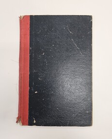
Book - Minute book, Minute book, Cheltenham Community Hospital, 1938
... Highway in Parkdale. The hospital opened in 1953 and serviced the community until 1996. On 1 August 1995, the hospital became a part of the Southern Health Care Network. The former hospital site is now the main location of Central Bayside...Highway in Parkdale. The hospital opened in 1953 and serviced the community until 1996. On 1 August 1995, the hospital became a part of the Southern Health Care Network. The former hospital site is now the main location of Central Bayside ...The Mordialloc-Cheltenham Community Hospital was a hospital in the suburb of Parkdale. Residents of Mordialloc and Chelsea worked towards a community hospital from the late 1930s. Having a community hospital meant residents who required routine surgery did not need to travel into Melbourne to the larger established hospitals. This was important at a time when few people had their own transport. For many years the Mordialloc Carnival Committee contributed to the cost of building the hospital, with one of its contributions to the ‘opening day’ appeal amounting to one thousand pounds, adding to the several thousand already committed. Construction work commenced on the Mordialloc-Cheltenham Community Hospital in 1950. on a site between Booth St and Carrier Ave on the Nepean Highway in Parkdale. The hospital opened in 1953 and serviced the community until 1996. On 1 August 1995, the hospital became a part of the Southern Health Care Network. The former hospital site is now the main location of Central Bayside Community Health Services.Black hard cover book with red spine. cheltenham, mordialloc, hospital, parkdale, health