
Showing 41 items matching "beechworth lake"
-
 The Beechworth Burke Museum
Photograph, Unknown
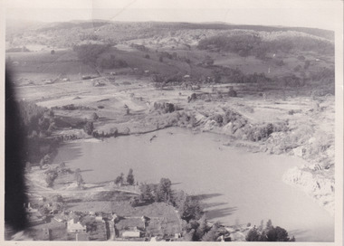
... Beechworth Lake...Aerial view of Lake Sambell, Beechworth with town views. Lake Sambell is a beautiful Victorian recreation lake and urban park with a unique history. ...Aerial view of Lake Sambell, Beechworth with town views. Lake Sambell is a beautiful Victorian recreation lake and urban park with a unique history. ...Aerial view of Lake Sambell, Beechworth with town views. Lake Sambell is a beautiful Victorian recreation lake and urban park with a unique history. It was created in the mid-1800s by the Rocky Mountain Mining company during the gold rush era and used as a mining site until the early 1900s, which brought Europeans into the area. It was turned into a reserve for residents in 1920 and is considered an icon of Beechworth as it represents the development of the community, human endeavour, and the spirit of the landscape.This photograph represents Lake Sambell with town views.Black and white reproduced rectangular photograph print on paper.Reverse: Stampbeechworth lake, lake sambell, aerial photo, construction, australian landscape, #beechworth, victoria -
 The Beechworth Burke Museum
Photograph, 1920
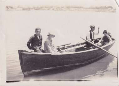
... #beechworth...Lake...Taken in 1920, depicted are four people in a rowing boat on Lake Sambell, Beechworth. From left to right, it is believed that the names of the people are Eric Beard, Mrs Doris Beard, and S/L to Bert Beard. ...This photograph represents the community's social use of the lake in 1920. #beechworth Lake Sambell Lake Sambell Boating Beechworth Lake social 1920 Victoria Reverse: LAKE SAMBELL/ c 1920/ from LTOR/ 1 ERIC? ...Taken in 1920, depicted are four people in a rowing boat on Lake Sambell, Beechworth. From left to right, it is believed that the names of the people are Eric Beard, Mrs Doris Beard, and S/L to Bert Beard. The last two figures are unknown. Lake Sambell is a beautiful Victorian recreation lake and urban park with a unique history. It was created in the mid-1800s by the Rocky Mountain Mining company during the gold rush era and used as a mining site until the early 1900s, which brought Europeans into the area. It was turned into a reserve for residents in 1920 and is considered an icon of Beechworth as it represents the development of the community, human endeavour, and the spirit of the landscape.This photograph represents the community's social use of the lake in 1920.Black and white rectangular photograph print on paper.Reverse: LAKE SAMBELL/ c 1920/ from LTOR/ 1 ERIC? - BERT'S SON/ 2 MRS DORIS BEARD/ 3 S/L TO BERT BEARD/ 4 #beechworth, lake sambell, lake sambell boating, beechworth lake, social, 1920, victoria -
 The Beechworth Burke Museum
Photograph, c1960
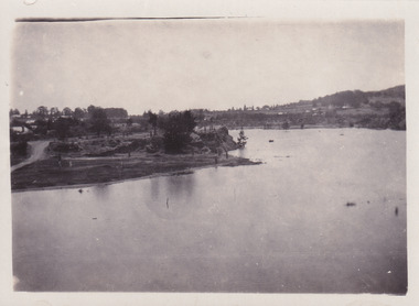
... ...beechworth lake...McConvill, a former resident of Beechworth, who is remembered in a street name adjacent to the lake. Residents of Beechworth have worked to raise funds to improve the Lake Sambell reserve several times, such as efforts in the 1930s and 1940s to raise the banks several feet to deepen the water for swimming purposes. ...The photograph is significant as it shows the level of development of Beechworth in the early to mid-Twentieth Century. beechworth beechworth lake lake sambell lake beechworth and district progress association forward beechworth committee ugly man mile of pennies wallace park lake sambell development scheme Wallace Park-Lake Sambell Development Scheme zwar bros zwar l.h. sambell j. mcconvill minister of lands commercial hotel len knight rocky mountain mining company rocky mountain mining co gold rush redevelopment transformation community fundraising Obverse: nil. ...The photograph depicts a view across the water at Lake Sambell. The image dates from approximately 1960. The present day park and reserve occupies the site of the former Rocky Mountain Mining Company, an open-cut sluice mine that began operations in the mid-Nineteenth Century and operated until the early 1900s, through the peak of Victoria’s Gold Rush. It was converted into a park and leisure area in the 1920s. Lake Sambell was formally opened to the public on Friday 5th October 1928 and was opened by the Victorian Government’s Minister of Lands, Mr Bailey, as part of initiatives to boost the economies and development of country towns. The lake was named after Mr L.H. Sambell, a shire engineer and secretary of the Forward Beechworth Committee who was involved in promoting the transformation of the mining site and promoting plantation forestry and tourism as alternative industries. £300 to begin the process was provided by Mr J. McConvill, a former resident of Beechworth, who is remembered in a street name adjacent to the lake. Residents of Beechworth have worked to raise funds to improve the Lake Sambell reserve several times, such as efforts in the 1930s and 1940s to raise the banks several feet to deepen the water for swimming purposes. Fundraising campaigns include the ‘Ugly Man’ competition conducted on behalf of the Wallace Park-Lake Sambell Development Scheme. The latter competition was run by the Fire Brigade Bend’s team as part of a larger competition called the ‘Mile of Pennies’; it was won by Mr Len Knight of Beechworth’s Commercial Hotel. The ‘Mile of Pennies’ was conducted at a Carnival held on New Year’s Eve, 1947. It was proposed by the Beechworth and District Progress Association. As well as improving swimming facilities, funds were raised to install a caravan park facility near the lake. Funds were also donated by commercial entities, such as £250 received from Zwar Bros. Pty Ltd. The photograph is significant as it shows the level of development of Beechworth in the early to mid-Twentieth Century. Sepia rectangular photograph printed on matte photographic paperObverse: nil. Reverse: 3470 / Velox (paper mark)beechworth, beechworth lake, lake sambell, lake, beechworth and district progress association, forward beechworth committee, ugly man, mile of pennies, wallace park lake sambell development scheme, wallace park-lake sambell development scheme, zwar bros, zwar, l.h. sambell, j. mcconvill, minister of lands, commercial hotel, len knight, rocky mountain mining company, rocky mountain mining co, gold rush, redevelopment, transformation, community fundraising -
 The Beechworth Burke Museum
Photograph, c1960
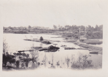
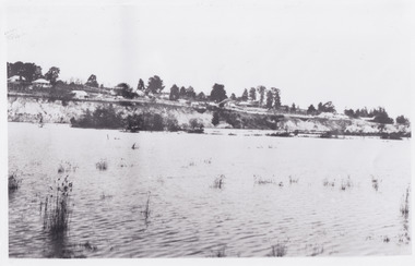
... ...beechworth lake...McConvill, a former resident of Beechworth, who is remembered in a street name adjacent to the lake. Residents of Beechworth have worked to raise funds to improve the Lake Sambell reserve several times, such as efforts in the 1930s and 1940s to raise the banks several feet to deepen the water for swimming purposes. ...The photograph is significant as it shows Lake Sambell at lower water levels, such as may have been experienced during period of drought. beechworth beechworth lake lake sambell lake beechworth and district progress association forward beechworth committee ugly man mile of pennies wallace park lake sambell development scheme Wallace Park-Lake Sambell Development Scheme zwar bros zwar l.h. sambell j. mcconvill minister of lands commercial hotel len knight rocky mountain mining company rocky mountain mining co gold rush redevelopment transformation community fundraising drought 1967 1960s Obverse: nil Reverse: 3470 Sepia rectangular photograph printed on matte photographic paper Photograph Photograph ...The photograph depicts a view across the water at Lake Sambell. The image is thought to date from the 1960s so may show the lake during a period of drought, such as that experienced across South-Eastern Australia in 1967. The present day park and reserve occupies the site of the former Rocky Mountain Mining Company, an open-cut sluice mine that began operations in the mid-Nineteenth Century and operated until the early 1900s, through the peak of Victoria’s Gold Rush. It was converted into a park and leisure area in the 1920s. Lake Sambell was formally opened to the public on Friday 5th October 1928 and was opened by the Victorian Government’s Minister of Lands, Mr Bailey, as part of initiatives to boost the economies and development of country towns. The lake was named after Mr L.H. Sambell, a shire engineer and secretary of the Forward Beechworth Committee who was involved in promoting the transformation of the mining site and promoting plantation forestry and tourism as alternative industries. £300 to begin the process was provided by Mr J. McConvill, a former resident of Beechworth, who is remembered in a street name adjacent to the lake. Residents of Beechworth have worked to raise funds to improve the Lake Sambell reserve several times, such as efforts in the 1930s and 1940s to raise the banks several feet to deepen the water for swimming purposes. Fundraising campaigns include the ‘Ugly Man’ competition conducted on behalf of the Wallace Park-Lake Sambell Development Scheme. The latter competition was run by the Fire Brigade Bend’s team as part of a larger competition called the ‘Mile of Pennies’; it was won by Mr Len Knight of Beechworth’s Commercial Hotel. The ‘Mile of Pennies’ was conducted at a Carnival held on New Year’s Eve, 1947. It was proposed by the Beechworth and District Progress Association. As well as improving swimming facilities, funds were raised to install a caravan park facility near the lake. Funds were also donated by commercial entities, such as £250 received from Zwar Bros. Pty Ltd.The photograph is significant as it shows Lake Sambell at lower water levels, such as may have been experienced during period of drought.Sepia rectangular photograph printed on matte photographic paperObverse: nil Reverse: 3470beechworth, beechworth lake, lake sambell, lake, beechworth and district progress association, forward beechworth committee, ugly man, mile of pennies, wallace park lake sambell development scheme, wallace park-lake sambell development scheme, zwar bros, zwar, l.h. sambell, j. mcconvill, minister of lands, commercial hotel, len knight, rocky mountain mining company, rocky mountain mining co, gold rush, redevelopment, transformation, community fundraising, drought, 1967, 1960s -
 The Beechworth Burke Museum
Photograph, c1960
... ...beechworth lake...McConvill, a former resident of Beechworth, who is remembered in a street name adjacent to the lake. Residents of Beechworth have worked to raise funds to improve the Lake Sambell reserve several times, such as efforts in the 1930s and 1940s to raise the banks several feet to deepen the water for swimming purposes. ...The photographs are significant as they show the level of development in Beechworth in the middle of the Twentieth Century. beechworth beechworth lake lake sambell lake beechworth and district progress association forward beechworth committee ugly man mile of pennies wallace park lake sambell development scheme Wallace Park-Lake Sambell Development Scheme zwar bros zwar l.h. sambell j. mcconvill minister of lands commercial hotel len knight rocky mountain mining company rocky mountain mining co gold rush redevelopment transformation community fundraising 3469.1: Obverse: nil Reverse: 3469-1 3469.2: Obverse: nil Reverse: 3469-2 3469.3: Obverse: nil Reverse: 3469-3 3469.4: Obverse: nil Reverse: 3469-4 Four sepia and black and white rectangular photographs printed on matte photographic paper. ...The photographs in this set depict views across the water at Lake Sambell. The images date from approximately 1960. The present day park and reserve occupies the site of the former Rocky Mountain Mining Company, an open-cut sluice mine that began operations in the mid-19th Century and operated until the early 1900s, through the peak of Victoria’s Gold Rush. It was converted into a park and leisure area in the 1920s. Lake Sambell was formally opened to the public on Friday 5th October 1928 and was opened by the Victorian Government’s Minister of Lands, Mr Bailey, as part of initiatives to boost the economies and development of country towns. The lake was named after Mr L.H. Sambell, a shire engineer and secretary of the Forward Beechworth Committee who was involved in promoting the transformation of the mining site and promoting plantation forestry and tourism as alternative industries. £300 to begin the process was provided by Mr J. McConvill, a former resident of Beechworth, who is remembered in a street name adjacent to the lake. Residents of Beechworth have worked to raise funds to improve the Lake Sambell reserve several times, such as efforts in the 1930s and 1940s to raise the banks several feet to deepen the water for swimming purposes. Fundraising campaigns include the ‘Ugly Man’ competition conducted on behalf of the Wallace Park-Lake Sambell Development Scheme. The latter competition was run by the Fire Brigade Bend’s team as part of a larger competition called the ‘Mile of Pennies’; it was won by Mr Len Knight of Beechworth’s Commercial Hotel. The ‘Mile of Pennies’ was conducted at a Carnival held on New Year’s Eve, 1947. It was proposed by the Beechworth and District Progress Association. As well as improving swimming facilities, funds were raised to install a caravan park facility near the lake. Funds were also donated by commercial entities, such as £250 received from Zwar Bros. Pty Ltd.The photographs are significant as they show the level of development in Beechworth in the middle of the Twentieth Century. Four sepia and black and white rectangular photographs printed on matte photographic paper. 3469.1: Obverse: nil Reverse: 3469-1 3469.2: Obverse: nil Reverse: 3469-2 3469.3: Obverse: nil Reverse: 3469-3 3469.4: Obverse: nil Reverse: 3469-4beechworth, beechworth lake, lake sambell, lake, beechworth and district progress association, forward beechworth committee, ugly man, mile of pennies, wallace park lake sambell development scheme, wallace park-lake sambell development scheme, zwar bros, zwar, l.h. sambell, j. mcconvill, minister of lands, commercial hotel, len knight, rocky mountain mining company, rocky mountain mining co, gold rush, redevelopment, transformation, community fundraising -
 The Beechworth Burke Museum
Photograph - Photographs, c1900
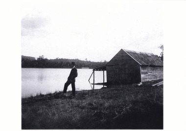
... ...Beechworth Lake...Both of these stereoscopic images depict a man standing by Lake Kerferd in Beechworth. The boathouse is located behind him. ...A03074.2 obverse: Lake Kerferd/ Beechworth/...Boathouse Lake Lake Kerferd man stereoscopic Beechworth Lake Beechworth Victoria trees boat wooden house A03074.2 obverse: Lake Kerferd/ Beechworth/ Black and white photograph mounted on card Photograph Photographs ...Both of these stereoscopic images depict a man standing by Lake Kerferd in Beechworth. The boathouse is located behind him. Lake Kerferd is significant because it was created in 1862 and Beechworth's main water supply. These images depict how Lake Kerferd was once used for boats because of the boathouse shown in the background of the image. However this boathouse appears to be in poor condition. This could give an indication that either boating was not a popular activity or that this boathouse in particular was not well looked after. Black and white photograph mounted on cardA03074.2 obverse: Lake Kerferd/ Beechworth/boathouse, lake, lake kerferd, man, stereoscopic, beechworth lake, beechworth, victoria, trees, boat, wooden house -
 The Beechworth Burke Museum
Postcard
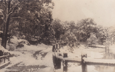
... beechworth...lake...Lake Kerferd during the winter season. With the photograph possibly been taken in the 1930s. The postcard holds Historic significance due to its connection to Beechworth and its Lake Kerford. ...This postcard depicts Lake Kerferd during the winter season. With the photograph possibly been taken in the 1930s.The postcard holds Historic significance due to its connection to Beechworth and its Lake Kerford. It demonstrates the interactions between nature and colonialists, especially how the lake is surrounded by man made fencing and roads. It also shows that there was frequent human interaction with the area, due to the small snow slopes where vehicles would travel across. Black and white rectangular postcard, printed on card.Reverse: 56. / A03092 / 97.2205 POSTCARD / AUSTRALIA / KODAK CORRESPONDENCE / ADDRESS ONLY / KODAK / AUSTRALIA 84 - 134 - 1beechworth, lake, postcard, burke museum, black and white photograph, lake kerford -
 The Beechworth Burke Museum
Photograph, 1960
... Beechworth Lake...lake and urban park with a unique history. It was created in the mid-1800s by the Rocky Mountain Mining company during the gold rush era and used as a mining site until the early 1900s, which brought Europeans into the area. It was turned into a reserve for residents in 1920 and is considered an icon of Beechworth...This photograph represents additional construction to Lake Sambell as a recreational reserve. Beechworth Lake Lake Lake Sambell construction #beechworth australian landscape Beechworth 1960s Victoria Black and white reproduced rectangular photograph print on paper. ...Taken in 1960, depicted is the construction of Lake Sambell, looking west across the lake. Lake Sambell is a beautiful Victorian recreation lake and urban park with a unique history. It was created in the mid-1800s by the Rocky Mountain Mining company during the gold rush era and used as a mining site until the early 1900s, which brought Europeans into the area. It was turned into a reserve for residents in 1920 and is considered an icon of Beechworth as it represents the development of the community, human endeavour, and the spirit of the landscape.This photograph represents additional construction to Lake Sambell as a recreational reserve.Black and white reproduced rectangular photograph print on paper.beechworth lake, lake, lake sambell, construction, #beechworth, australian landscape, beechworth 1960s, victoria -
 The Beechworth Burke Museum
Photograph
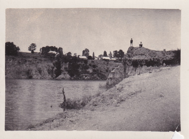
... ...Beechworth Lake...McConvill, a former resident of Beechworth, who is remembered in a street name adjacent to the lake. An article in the Ovens and Murray Advertiser on Saturday, 5th May, 1917, gives some insight into issues in the Rocky Mountain Mining Company’s final years. ...The photograph is significant as it contributes to knowledge about how Beechworth reinvented itself after the Gold rush period, and more broadly how country towns repurpose and redevelop infrastructure and facilities to meet the present needs of their population. Beechworth Beechworth Lake Lake Sambell L.H. Sambell McConvill Rocky Mountain Mining Company Rocky Mountain Mining Co Minister of Lands Forward Beechworth Committee Wallace Park-Lake Sambell Development Scheme Wallace Park Lake Sambell Development Scheme Lake Sambell J. ...The photograph depicts two young men standing atop a prominent outcrop at Lake Sambell, with buildings visible on the further shore. The present day park and reserve occupies the site of the former Rocky Mountain Mining Company, an open-cut sluice mine that began operations in the mid-Nineteenth Century and operated until the early 1900s, through the peak of Victoria’s Gold Rush. It was converted into a park and leisure area in the 1920s. Lake Sambell was formally opened to the public on Friday 5th October 1928 and was opened by the Victorian Government’s Minister of Lands, Mr Bailey, as part of initiatives to boost the economies and development of country towns. The lake was named after Mr L.H. Sambell, a shire engineer and secretary of the Forward Beechworth Committee who was involved in promoting the transformation of the mining site and promoting plantation forestry and tourism as alternative industries. £300 to begin the process was provided by Mr J. McConvill, a former resident of Beechworth, who is remembered in a street name adjacent to the lake. An article in the Ovens and Murray Advertiser on Saturday, 5th May, 1917, gives some insight into issues in the Rocky Mountain Mining Company’s final years. The writer details the 1917 annual meeting of the Rocky Mountain Mining Company, stating that locals present appeared ‘well pleased this important local industry is in such a prosperous condition and that future prospects are so encouraging’. The author describes plans to give workers a bonus as evidence of profit-sharing that would ‘bridge the gulf between capital and labour’. The article concludes, however, with the statement that ‘there is a little arithmetical puzzle in the report in connection with the dredging operations I have been unable to solve.' The photograph is significant as it contributes to knowledge about how Beechworth reinvented itself after the Gold rush period, and more broadly how country towns repurpose and redevelop infrastructure and facilities to meet the present needs of their population. Sepia rectangular photograph printed on matte photographic paper. Obverse: nil. Reverse: 3471 / Velox (paper mark)beechworth, beechworth lake, lake sambell, l.h. sambell, mcconvill, rocky mountain mining company, rocky mountain mining co, minister of lands, forward beechworth committee, wallace park-lake sambell development scheme, wallace park lake sambell development scheme, lake, sambell, j. mcconvill, recreation, reserve, park, transformation, repurposed, redeveloped -
 The Beechworth Burke Museum
Photograph, 1960s
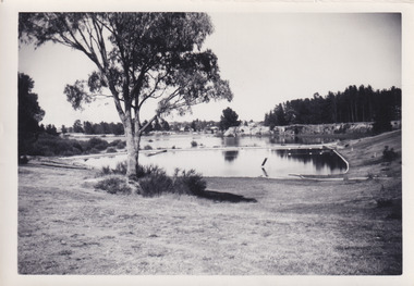
... ...Beechworth 1960s...Lake...Throughout the 1940s the Beechworth Swimming Club tried to raise awareness and funds to address the structural engineering issues, raise the water levels, and improve swimming facilities at the lake. ...Throughout the 1940s the Beechworth Swimming Club tried to raise awareness and funds to address the structural engineering issues, raise the water levels, and improve swimming facilities at the lake. ...This photograph was taken in the 1960s of the Lake Sambell Swimming Pool with the lake itself in the background. The swimming pool area has multiple features including park benches, a water slide, and a fenced area with a diving pontoon for lap swimming and racing. Lake Sambell Swimming Pool was completed in 1961, driven largely by R.E. Carter, Beechworth shire engineer from 1954-63. Carter advocated for improvements to the lake and surrounding area in order to encourage tourism in Beechworth. The opening of the swimming pool was part of many improvements to Lake Sambell made during this period by Carter including establishing the caravan park in 1959, water skiing and boating facilities, and increasing the lake surface in 1964. These improvements were financed mainly by grants from the Tourist Development Authority. For many decades, members of the local Beechworth community had advocated for the development of swimming pool at the lake that would include a safe wadding area and Olympic standard lanes for laps and races. Throughout the 1940s the Beechworth Swimming Club tried to raise awareness and funds to address the structural engineering issues, raise the water levels, and improve swimming facilities at the lake. Beechworth Swimming Club hosted a swimming carnival at the lake in 1948, but it was decided due to several issues at the event, that no further carnivals would be hosted until necessary improvements were made to the area. Swimming pools, both artificial and built into natural environments, were an extremely popular public space throughout the 20th century in Australia. Increasing in accessibility and popularity through such developments as less restrictive swimming outfits during 1920s, public building works during the 1920s and 30s, and an increase in leisure time during a period of post-war prosperity. This photograph is of historical significance as it documents the newly established Lake Sambell Swimming Pool in the 1960s after many decades of discussion and proposals around creating a safe swimming area at the lake. Further, this photograph provides important social insights into the facilities and uses of this pool in the 1960s, and underlines the significant role public swimming pools have played in Australian social and recreational experiences. Black and white rectangle photograph printed on photographic paper and unmounted.Reverse: 3537 / C798lake sambell swimming pool, lake sambell water slide, water slide 1960s, lake sambell pontoon, lake sambell 1960s, lake swimming pool, lake swimming, beechworth swimming club, swimming pools in the 20th century, r.e. carter, tourist development authority, beechworth 1960s, lake water slide, lake sambell, wadding pool, swimming, swimming pool 1960s, leisure, recreation 1960s -
 The Beechworth Burke Museum
Photograph, 1960
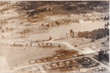
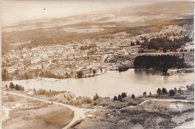
... ...Beechworth 1960s...Lake...lake and urban park with a unique history. It was created in the mid-1800s by the Rocky Mountain Mining company during the gold rush era and used as a mining site until the early 1900s, which brought Europeans into the area. It was turned into a reserve for residents in 1920 and is considered an icon of Beechworth...This photograph represents what Lake Sambell looked like in 1960. Lake Sambell #beechworth Beechworth 1960s Lake Victoria australian landscape Mining Rocky Mountain Mining Company Black and white reproduced rectangular photograph print on paper. ...Taken in 1960, depicted is an aerial view of Lake Sambell and the surrounding township. Lake Sambell is a beautiful Victorian recreation lake and urban park with a unique history. It was created in the mid-1800s by the Rocky Mountain Mining company during the gold rush era and used as a mining site until the early 1900s, which brought Europeans into the area. It was turned into a reserve for residents in 1920 and is considered an icon of Beechworth as it represents the development of the community, human endeavour, and the spirit of the landscape.This photograph represents what Lake Sambell looked like in 1960.Black and white reproduced rectangular photograph print on paper.lake sambell, #beechworth, beechworth 1960s, lake, victoria, australian landscape, mining, rocky mountain mining company -
 The Beechworth Burke Museum
Photograph, 1960s
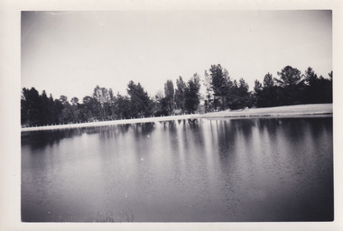
... ...Lake Sambell Caravan Park...Beechworth...In 1939 the water levels were low, and the lake was considered both an eyesore and ‘mudhole’, Beechworth Shire Council sort funding to raise the height of the lake six feet to improve the quality of water. ...Lake Sambell L.H. Sambell R.E. Carter Rocky Mountain Mining Company Forward Beechworth Committee Beechworth Swimming Club Wallace Park Lake Sambell Development Scheme Lake Sambell Caravan Park Beechworth 1960s Lake Sambell Swimming Pool Lake Sambell Boating Lake Sambell Fishing Swimming Boating Water skiing Fishing Post-war prosperity Minister of Lands Artificial Lake Open Cut Sluice Mine Lake Reverse: 3534 C798 Black and white rectangle photograph printed on photographic paper and unmounted. ...This photograph was taken in the 1960s at Lake Sambell and is a view across the lake from the east side, the photo was taken during a period of improvements to the lake and surrounding area. Lake Sambell is an artificial lake that was created on the site of the old Rocky Mountain Mining Company workings and was officially opened by Minister for Lands, Mr Baily, on October 5, 1928. The disused and unattractive remains of the mine were converted into a recreational area intended for swimming, boating, and fishing. The lake is named after Mr L.H. Sambell, shire engineer and secretary of the Forward Beechworth Committee, who advocated for the enhancement of Beechworth into a tourist destination and was central to the planning and establishment of the lake. Funding for the project was raised through both competition funds and donations. Since the construction in 1928 several engineering issues have arisen. In 1939 the water levels were low, and the lake was considered both an eyesore and ‘mudhole’, Beechworth Shire Council sort funding to raise the height of the lake six feet to improve the quality of water. Throughout the 1940s the Beechworth Swimming Club sort to address the structural engineering issues and improve swimming facilities at the lake. R.E. Carter, similar to L.H. Sambell, was a shire engineer who advocated the importance of positioning Beechworth as a tourist destination. Carter held the position of shire engineer from 1954-63 and organised many improvements to the Lake Sambell area including the caravan park in 1959, the lake swimming pool in 1961, water skiing and boating facilities, and increased the lake surface area in 1964. These improvements to the lake also reflect an increase in leisure time and access to travel during a period of post-war prosperity in Australia during the 1950s and 60s. This photograph is of historical significance as it documents Lake Sambell in the 1960s after a series of enhancements to the lake area to improve its appearance and usability for both the people of Beechworth and tourists. It is also of social significance in providing an insight into the increase in leisure time and access to travel during a period of post-war prosperity. Black and white rectangle photograph printed on photographic paper and unmounted.Reverse: 3534 C798lake sambell, l.h. sambell, r.e. carter, rocky mountain mining company, forward beechworth committee, beechworth swimming club, wallace park lake sambell development scheme, lake sambell caravan park, beechworth 1960s, lake sambell swimming pool, lake sambell boating, lake sambell fishing, swimming, boating, water skiing, fishing, post-war prosperity, minister of lands, artificial lake, open cut sluice mine, lake -
 The Beechworth Burke Museum
Photograph, 1960s
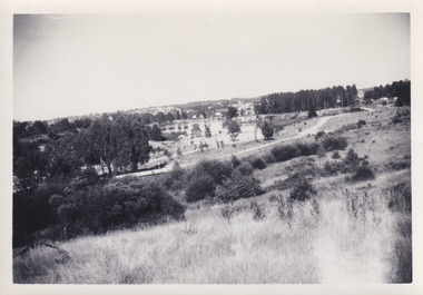
... ...Beechworth 1960s...Lake...In 1939 the water levels were low, and the lake was considered both an eyesore and ‘mudhole’, Beechworth Shire Council sort funding to raise the height of the lake six feet to improve the quality of water. ... Swimming Club Forward Beechworth Committee Minister of Lands Tourist Development Authority Lake swimming Swimming Boating Fishing Water skiing Beechworth 1960s Lake Sambell Fishing Lake Sambell Boating Reverse: 1 / [logo KODAK/ VELOX/ PAPER] / C798 / 3535 Black and white rectangle photograph printed on matte photographic paper and unmounted. ...This photo was taken in the 1960s from a northeast position looking down towards Lake Sambell, the caravan park, and the surrounding area. This photo was taken during a period of rejuvenation for the lake area including the opening of the caravan park in 1959 and the swimming pool area in 1961 (this pool is just visible in the centre of the photo). The popularity of caravanning in Australia exploded during this post-war period of the late 1950s and 1960’s. This popularity was driven by multiple factors, including: the stopping of fuel rations, the accessibility of car ownership through the manufacturing of affordable cars, technological developments in caravan design, and the increase in prosperity and leisure time for many Australians. Lake Sambell is an artificial lake that was developed on the previous site of the Rocky Mountain Mining Company workings and was officially opened by Minister for Lands, Mr Baily, on October 5, 1928. The disused and unattractive remains of the mine were converted into a recreational area intended for swimming, boating, and fishing. The lake is named after Mr L.H. Sambell, shire engineer and secretary of the Forward Beechworth Committee, who advocated for the enhancement of Beechworth into a tourist destination and was central to the planning and establishment of the lake. Funding for the project was raised by both competition funds and donations. Since the construction in 1928 several engineering issues have arisen. In 1939 the water levels were low, and the lake was considered both an eyesore and ‘mudhole’, Beechworth Shire Council sort funding to raise the height of the lake six feet to improve the quality of water. Throughout the 1940s the Beechworth Swimming Club tried to raise awareness and funds to address the structural engineering issues and improve swimming facilities at the lake. R.E. Carter, similar to L.H. Sambell, was a shire engineer who advocated the importance of positioning Beechworth as a tourist destination. Carter held the position from 1954-63 and organised many improvements to the Lake Sambell area including the caravan park in 1959, the lake swimming pool in 1961, water skiing and boating facilities, and increased the lake surface are in 1964. These improvements were financed mainly by grants from the Tourist Development Authority. This photograph is of historical significance as it documents Lake Sambell and the surrounding area in the 1960s after a phase of enhancements to improve the appearance and usability for both the people of Beechworth and tourists. It is also of social significance in providing an insight into the increase in leisure time and access to travel during a period of post-war prosperity.Black and white rectangle photograph printed on matte photographic paper and unmounted.Reverse: 1 / [logo KODAK/ VELOX/ PAPER] / C798 / 3535lake sambell, lake sambell caravan park, lake sambell swimming pool, caravan park, caravanning 1960s, rocky mountain mining company, l.h. sambell, r.e. carter, beechworth swimming club, forward beechworth committee, minister of lands, tourist development authority, lake swimming, swimming, boating, fishing, water skiing, beechworth 1960s, lake sambell fishing, lake sambell boating -
 The Beechworth Burke Museum
Photograph, 1960s
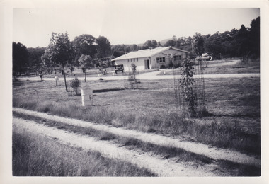
... Lake Sambell...Caravanning 1960s...caravan park...Rocky Mountain Mining Company...Kodak Velox Paper...R.E. Carter...L.H. Sambell...Caravan Electricity Outlets...Tourist Development Authority...Post-war prosperity...Forward Beechworth...Lake Sambell Caravan Park opened in 1959 owing to the work of R.E. Carter, Beechworth Shire engineer from 1954-63. ...Lake Sambell Caravan Park Lake Sambell Caravanning 1960s caravan park Rocky Mountain Mining Company Kodak Velox Paper R.E. Carter L.H. Sambell Caravan Electricity Outlets Tourist Development Authority Post-war prosperity Forward Beechworth Committee Lake Sambell Boating Lake Sambell Swimming Pool Lake Sambell Fishing Artificial Lake Travel 1960s Recreation 1960s Reverse: 3536/ [logo back printing: KODAK/ VELOX/ PAPER] / C798 Black and white rectangle photograph printed on photographic paper and unmounted. ...This photograph was taken in the 1960s at Lake Sambell Caravan Park and visible in the photograph are individual caravan sites with electricity outlets, a large single-story building with a caravan park banner, dirt roads, a freestanding message board, and a parked car. Lake Sambell Caravan Park opened in 1959 owing to the work of R.E. Carter, Beechworth Shire engineer from 1954-63. Carter advocated for improvements to the lake and surrounding area in order to encourage tourism in Beechworth. The opening of the caravan park was part of many improvements to Lake Sambell made in this period by Carter including: the swimming pool in 1961, water skiing and boating facilities, and increased lake surface in 1964. These improvements were financed mainly by grants from the Tourist Development Authority. The popularity of caravanning in Australia exploded during this post-war period of the late 1950s and 1960s. This popularity was driven by multiple factors, including: the stopping of fuel rations, the accessibility of car ownership through the manufacturing of affordable cars, technological developments in caravan design, and the increase in prosperity and leisure time for many Australians. Facilities such as electrical outlets to power caravans are present in this photograph of Lake Sambell Caravan Park. Lake Sambell is an artificial lake that was developed on the previous site of the Rocky Mountain Mining Company workings and was officially opened by Minister for Lands, Mr Baily, on October 5, 1928. The disused and unattractive remains of the mine were converted into a recreational area intended for swimming, boating, and fishing. The lake is named after Mr L.H. Sambell, shire engineer and secretary of the Forward Beechworth Committee, who advocated for the enhancement of Beechworth into a tourist destination and was central to the planning and establishment of the lake. This photograph is of historical and social significance in providing insight into caravanning during the 1960s in Australia. Caravanning was extremely popular during the 1960s in Australia due to multiple social and economic factors including the stopping of fuel rations, the accessibility of car ownership through the manufacturing of affordable cars, technological developments in caravan design, and the increase in prosperity and leisure time for many Australians.Black and white rectangle photograph printed on photographic paper and unmounted.Reverse: 3536/ [logo back printing: KODAK/ VELOX/ PAPER] / C798 lake sambell caravan park, lake sambell, caravanning 1960s, caravan park, rocky mountain mining company, kodak velox paper, r.e. carter, l.h. sambell, caravan electricity outlets, tourist development authority, post-war prosperity, forward beechworth committee, lake sambell boating, lake sambell swimming pool, lake sambell fishing, artificial lake, travel 1960s, recreation 1960s -
 The Beechworth Burke Museum
Postcard - Postcard - Reproduction, c.1930's - 1940's
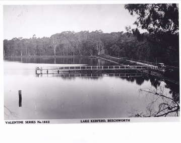
... Lake Kerferd...Hurdle Swamp...Gold mining...Beechworth...The photograph copy was recorded made c. 1930's - 40's, depicting Lake Kerferd, Beechworth. Lake Kerferd was built in 1862 to assist for gold mining activities as it held the waters of the Hurdle Swamp. ...5461 Obverse: Valentine Series No.1862/LAKE KERFERD, BEECHWORTH 5461 Reverse: BMM2961/5461...The photograph copy was recorded made c. 1930's - 40's, depicting Lake Kerferd, Beechworth. Lake Kerferd was built in 1862 to assist for gold mining activities as it held the waters of the Hurdle Swamp. ...This photograph is a copy of the Valentine series postcard originally produced c.1920. The photograph copy was recorded made c. 1930's - 40's, depicting Lake Kerferd, Beechworth. Lake Kerferd was built in 1862 to assist for gold mining activities as it held the waters of the Hurdle Swamp. The retaining wall built to create Lake Kerferd is depicted in the photograph adjacent to a narrow road, the make of the single automobile shown is consistent with the date recorded. The photograph is socially significant due to the connection of Beechworth in the past, present and future. Originally developed for gold mining activities which is a strong research area as the foundation of many towns in Australia's history. Black and white rectangular photograph printed on matte photographic paper.5461 Obverse: Valentine Series No.1862/LAKE KERFERD, BEECHWORTH 5461 Reverse: BMM2961/5461burke museum, lake kerferd, hurdle swamp, gold mining, beechworth, valentine series postcard, automobile, trees, jetty, reflection, car -
 The Beechworth Burke Museum
Photograph - Photograph - Reproduction
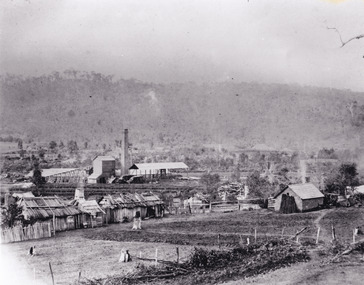
... Lake Sambell. The company employed A.L Martin to survey an area for a tunnel underneath Beechworth and Johnson Stephens to dig it. ...Lake Sambell. The company employed A.L Martin to survey an area for a tunnel underneath Beechworth and Johnson Stephens to dig it. ...The photograph is a reproduction of a postcard from the Rocky Mountain Mining Company. In 1875, the Rocky Mountain Extended Gold Sluicing Company Ltd was created, utilising the previous Rocky Mountain claim for the area near Lake Sambell. The company employed A.L Martin to survey an area for a tunnel underneath Beechworth and Johnson Stephens to dig it. The tunnel was built at a rate of 40 feet a month and eventually measured 800 metres. The tunnel was a true accomplishment both in the present and during the 19th century. It was considered to be a marvelous engineering feat. Beechworth is renowned for its hydraulic sluice method of mining. This involved soil being exposed to torrents of water from high-pressure hoses. From 1876 until its closure in 1921, the mine produced an astounding 47,926 ozs of gold. Companies like this were the source of income for many Chinese gold-diggers who sought to make their fortune on the goldfields of Beechworth. During the height of the rush, the town had around 7,000 Chinese inhabitants living on the outskirts of town as they were not permitted to live within Beechworth itself.This image of the Rocky Mountain mine is historically significant as the mining complex is now non-existent, with the only remains being the tunnel built in 1880 by the company, which was considered one of the greatest engineering feats of the time. The image also provides a first-hand look into the social and cultural networks at play during the 19th century with racial segregation of the Chinese at the 'Chinese Camp', as well as an insight into Beechworth's origins during the Gold Rush.Black and white rectangular reproduced photograph printed on paperbeechworth, rocky mountain mine, sluicing, gold rush, mining, gold -
 The Beechworth Burke Museum
Audio - Oral History, Jennifer Williams, Dr Roy Phillips, 8th October 2000 (exact date unclear)
... Beechworth...Yackandandah...Wangaratta...mining...dredging...1910s...1920s...1930s...Chinese community...Typhoid...Lake...Roy Phillips was born in 1907 in Yackandandah and moved with his family to Beechworth when he was five years old. His father was involved in dredging operations at Lake Sambell but his parents also had other family living in Beechworth, with whom they lived. ...Roy Phillips was born in 1907 in Yackandandah and moved with his family to Beechworth when he was five years old. His father was involved in dredging operations at Lake Sambell but his parents also had other family living in Beechworth, with whom they lived. ...Roy Phillips was born in 1907 in Yackandandah and moved with his family to Beechworth when he was five years old. His father was involved in dredging operations at Lake Sambell but his parents also had other family living in Beechworth, with whom they lived. Dr Phillips tells vivid stories about life in Beechworth in the first half of the Twentieth Century, from the daily lives of young children of the time to the town's relationship to the local Chinese community. He discusses features of the landscape such as 'The Rock' at which community concerts were held and 'The Echo' (an echo-sounding point over a nearby gully) which he states are no longer used in the same way. He also discusses changing community attitudes to various issues, for example, 'not being coddled' as a child but living in a town with very strict rules about people of different religions mingling. This oral history recording was part of a project conducted by Jennifer Williams in the year 2000 to capture the everyday life and struggles in Beechworth during the twentieth century. This project involved recording seventy oral histories on cassette tapes of local Beechworth residents which were then published in a book titled: Listen to what they say: voices of twentieth century Beechworth. These cassette tapes were digitised in July 2021 with funds made available by the Friends of the Burke.Dr Roy Phillips' account of his life in Beechworth in the early part of the 20th Century is historically and socially significant to the cultural heritage of the region. He describes town life from a child's point of view during a time of transition to life after the Gold Rush era, including social tensions existing between cultural groups such as the Chinese community and European-heritage townspeople and between people of different religious groups in Beechworth. This oral history account is socially and historically significant as it is a part of a broader collection of interviews conducted by Jennifer Williams which were published in the book 'Listen to what they say: voices of twentieth-century Beechworth.' While the township of Beechworth is known for its history as a gold rush town, these accounts provide a unique insight into the day-to-day life of the town's residents during the 20th century, many of which will have now been lost if they had not been preserved.This is a digital copy of a recording that was originally captured on a cassette tape. The cassette tape is black with a horizontal white strip and is currently stored in a clear flat plastic rectangular container. It holds up 40 minutes of recordings on each side.Dr Roy Phillips /beechworth, yackandandah, wangaratta, mining, dredging, 1910s, 1920s, 1930s, chinese community, typhoid, lake kerferd, reminiscences, memories, childhood, lake sambell, alcoholism, new year celebrations, transport, horses, foresters lodge, oddfellows lodge, funeral practices, child-rearing practices, star hotel, the rock, racism, chinese dragon, benevolent society, star lane coach building factory, outdoor concerts, gold, jimmy ingram, kelly gang, kelly family, churches, catholic, methodist, protestant, anglican, confuscionist, buddhism, women's christian temperance association, hotels, twentieth century, coronation of king george iv, echo point, the echo, tippany cat, marbles, children's games, cornish, cornwall, listen to what they say, oral history -
 The Beechworth Burke Museum
Audio - Oral History, Jennifer Williams, Isabel Wells, 24th February 2000
... Beechworth...Mr. Newey...Ford street...butcher...Mayday Hills Hospital...The Ovens and Murray Home...fire brigade...23rd March 1867...fire...osteoarthritis...Boxing Day...horseraces...Lake...Lake Kerferd or Buffalo. This oral history recording was part of a project conducted by Jennifer Williams in the year 2000 to capture the everyday life and struggles in Beechworth during the twentieth century. ...Lake Kerferd or Buffalo. This oral history recording was part of a project conducted by Jennifer Williams in the year 2000 to capture the everyday life and struggles in Beechworth during the twentieth century. ...Isabel Wells was born in Beechworth in 1914. Her father, Mr. Newey, was a butcher; his shop was in Ford street and he took over from his grandfather. The family business, along with the local residents, was supplying the main government institutions in the region, like Mayday Hills Hospital and The Ovens and Murray Home, making a large percentage of his profit. Mr. Newey was also a captain of the fire brigade and Isabel mentioned that there were more fires happening in those days. The menace of a huge fire was impending in Beechworth for many years, due to the lack of adequate water supply and the absence of trained firefighters. The first fire brigade in the town was voluntary and was formed in 1858 under Superintendent Luke Reilly. A few other schemes deployed the following years, with all failing to sufficiently control the fires that occurred, until the creation of the first reliable fire brigade in the 1870s. The worst fire in the town's history happened on 23rd March 1867; it swept through many shops and the post office, leaving behind a damage cost estimated at £12,000. Isabel's mother was in a wheelchair, suffering from osteoarthritis; thus, Isabel had taken over the responsibility for looking after her mother and assisting her with daily living needs and personal care activities. She used to play golf and tennis and she was a member of the town tennis club. In terms of social life, Boxing Day was a big occasion for the town, with horse-races and games taking place. According to her narration, the use of cars was a turning point in the town's social activities, since people were able to visit nearby places and take day trips, such as having a picnic at Lake Kerferd or Buffalo. This oral history recording was part of a project conducted by Jennifer Williams in the year 2000 to capture the everyday life and struggles in Beechworth during the twentieth century. This project involved recording seventy oral histories on cassette tapes of local Beechworth residents which were then published in a book titled: Listen to what they say: voices of twentieth century Beechworth. These cassette tapes were digitised in July 2021 with funds made available by the Friends of the Burke. Isabel's account of her life in Beechworth and the local area during the 20th century is historically and socially significant as it offers valuable information about the business activity in the region and provides a deeper insight into the operation of butcher shops and meat supply during the first half of the previous century. Additionally, it offers invaluable information about the everyday life of people living in Beechworth, and highlights aspects of the overall social life and activities.This is a digital copy of a recording that was originally captured on a cassette tape. The cassette tape is black with a horizontal white strip and is currently stored in a clear flat plastic rectangular container. It holds up 40 minutes of recordings on each side.Mrs Isabel Wells/ isabel wells, beechworth, mr. newey, ford street, butcher, mayday hills hospital, the ovens and murray home, fire brigade, 23rd march 1867, fire, osteoarthritis, boxing day, horseraces, lake kerferd, buffalo, picnic, cars, firefighters, luke reilly, wheelchair -
 The Beechworth Burke Museum
Postcard, 1910 - 1912
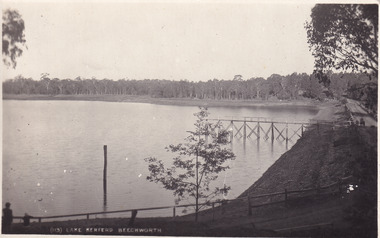
... Lake...horse drawn carriage...horse drawn cart...Kodak...Australia...gum trees...gravel road...Beechworth...Obverse: (113) Lake Kerferd Beechworth / Reverse: Beechworth / 29.11.19 / [ Stamped: POST CARD / KODAK AUSTRALIA / Dear Win / Gald to hear that you / have made up your mind about / Perc / He seems a decent enough chap / too / Anyway, Thanks for the letter / Dont exactly know when we are / returning / will write later. ...This postcard is significant because Lake Kerferd itself is significant within Beechworth's history. This lake was constructed in 1862 and was named after the former Beechworth Mayor, Hon. ...This photograph is taken of Lake Kerferd in around 1910. The photograph shows the road circling around the large lake and the jetty on the lake. On the other side, there is a written message from Fred Pulling to Win Pulling. Fred seems to have gone away and was not sure when he would return. He was also glad to hear about a gentlemen called Perc, who he stated to be a 'decent enough chap'.This postcard is significant because Lake Kerferd itself is significant within Beechworth's history. This lake was constructed in 1862 and was named after the former Beechworth Mayor, Hon. G B Kerferd. This lake was originally constructed to supply the town with water. Fred's correspondence with Win demonstrates a glimpse into what life was like during this time. Black and white rectangular postcard printed on cardObverse: (113) Lake Kerferd Beechworth / Reverse: Beechworth / 29.11.19 / [ Stamped: POST CARD / KODAK AUSTRALIA / Dear Win / Gald to hear that you / have made up your mind about / Perc / He seems a decent enough chap / too / Anyway, Thanks for the letter / Dont exactly know when we are / returning / will write later. Regards / to Nell of course, and H. (indecipherable) / Lots of love / Fred / lake kerferd, jetty, chap, postcard, letter, trees, lake, horse drawn carriage, horse drawn cart, kodak, australia, gum trees, gravel road, beechworth, kerferd -
 The Beechworth Burke Museum
Photograph, c1900
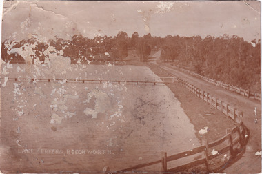
... Lake Kerferd...Kerferd...road...photograph...trees...gum tree...jetty...wooden fence...gravel road...Australia...Victoria...Beechworth...Lake Kerferd, Beechworth / ...This made it very important to the community. spillway lake dam Lake Kerferd Kerferd road photograph trees gum tree jetty wooden fence gravel road Australia Victoria Beechworth 1900s Beechworth waterworks water Water Supply Lake Kerferd, Beechworth / Black and white rectangular photograph printed on paper Photograph Photograph ...This photograph is of Lake Kerferd in the early 1900s. Both the spillway for the lake and the jetty can be seen. There is also a road that wraps around the lake and eventually disappears into the trees. This photograph is significant because it shows Lake Kerferd at the beginning of the twentieth century. The lake itself is significant because it was Beechworth's main source of water. This made it very important to the community.Black and white rectangular photograph printed on paperLake Kerferd, Beechworth / spillway, lake, dam, lake kerferd, kerferd, road, photograph, trees, gum tree, jetty, wooden fence, gravel road, australia, victoria, beechworth, 1900s beechworth, waterworks, water, water supply -
 The Beechworth Burke Museum
Photograph - Postcard, c1900
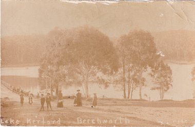
... lake...sepia photograph...photograph...Beechworth...This is a photograph of Lake Kerferd in Beechworth taken in the late nineteenth or early twentieth centuries. ...Obverse: Lake Kerferd Beechworth / wade / Reverse: Postcard / 5568 / This space may be used for correspondence / (For Address Only) /...Lake Kerferd itself was also Beechworth's main water supply. ...This is a photograph of Lake Kerferd in Beechworth taken in the late nineteenth or early twentieth centuries. It depicts two women, two young boys and four young girls standing in front of the lake. The women seem to be either the mothers or caregivers of the children. This photograph is significant because it depicts a group of people enjoying a outing at Lake Kerferd. This demonstrates that Lake Kerferd was a place of enjoyment for the people that lived in Beechworth during this time period. Lake Kerferd itself was also Beechworth's main water supply. This makes it very important to the community who lived there. Sepia rectangular postcard printed on paperObverse: Lake Kerferd Beechworth / wade / Reverse: Postcard / 5568 / This space may be used for correspondence / (For Address Only) /children, lake kerferd, lake, sepia photograph, photograph, beechworth, mothers, young girls, young boy, trees, caregivers, victoria, outing -
 The Beechworth Burke Museum
Photograph - Postcard, R Warren, 1920
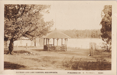
... Lake Kerferd...Beechworth...2960.1- Obverse: Pavilion and Lake Kerferd, Beechworth / Published by R Warren / M.5311/ 2960.1- Reverse: POST CARD / Correspondence / Address Only / 2960.2-Obverse: Picnic Grounds, Lake Kerferd, Beechworth / Real Photo Series / M.5949/ 2960.2-Reverse: Published by the Valentine Publishing Co Pty (indecipherable) Queen St (indecipherable) / Valentines / Real Photo Series/ ...In addition, it is also significant because this photograph indicates that it was a popular picnic spot during the beginning of the twentieth century. Lake Kerferd Beechworth picnic outing park trees lake picnic grounds victoria district views pavilion Warren photograph 1920 2960.1- Obverse: Pavilion and Lake Kerferd, Beechworth / Published by R Warren / M.5311/ 2960.1- Reverse: POST CARD / Correspondence / Address Only / 2960.2-Obverse: Picnic Grounds, Lake Kerferd, Beechworth / Real Photo Series / M.5949/ 2960.2-Reverse: Published by the Valentine Publishing Co Pty (indecipherable) Queen St (indecipherable) / Valentines / Real Photo Series/ Sepia rectangular postcard printed on paper Photograph Postcard R Warren Valentine Publishing Co. ...These photographs are of Lake Kerferd and the Pavilion. There are no people in the first image but in the second image there are a man and women sitting on the railing of the pavilion. The Pavilion sits in a picnic ground and there are a few trees around it. Lake Kerferd is significant to Beechworth and the surrounding area because it was the main source of water for the community. In addition, it is also significant because this photograph indicates that it was a popular picnic spot during the beginning of the twentieth century. Sepia rectangular postcard printed on paper 2960.1- Obverse: Pavilion and Lake Kerferd, Beechworth / Published by R Warren / M.5311/ 2960.1- Reverse: POST CARD / Correspondence / Address Only / 2960.2-Obverse: Picnic Grounds, Lake Kerferd, Beechworth / Real Photo Series / M.5949/ 2960.2-Reverse: Published by the Valentine Publishing Co Pty (indecipherable) Queen St (indecipherable) / Valentines / Real Photo Series/ lake kerferd, beechworth, picnic, outing, park, trees, lake, picnic grounds, victoria, district views, pavilion, warren, photograph, 1920 -
 The Beechworth Burke Museum
Photograph - Postcard, c1900
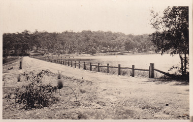
... Lake Kerferd...Beechworth...The lake was named after George Briscoe Kerferd (1831–1889) who was responsible for Beechworth's water scheme. ...It also demonstrates the political identity of George Briscoe Kerferd and the Beechworth Municipal Council. Lake Kerferd Beechworth water scheme water reserve reservoir Legislative Assembly Hon. ...The construction on Lake Kerferd began in 1862 however it wasn't completed until 1874 due to engineering and funding issues. The lake was named after George Briscoe Kerferd (1831–1889) who was responsible for Beechworth's water scheme. George Briscoe Kerferd was born on 21 January 1831 in Liverpool, England and arrived in Melbourne April 1853. He spent his first years in Australia in Bendigo before settling down in Beechworth as a wine and spirits merchant. He married Ann Martindale on 17th December 1853 at St James Cathedral, Melbourne and between them they had three sons and five daughters. Kerferd began his political and legal career in Beechworth when he was first elected to the Municipal Council in May 1857. Later he would be elected to the Legislative Assembly for the Ovens District in November 1864, and continued to represent the area until February 1886. This photograph is historically significant as it provides insight into the water reserves of Victoria. It also demonstrates the political identity of George Briscoe Kerferd and the Beechworth Municipal Council.Sepia rectangular postcard printed on paperObverse: Reverse: 83-131-1/ Post Card/ Correspondence / Address Only / BMM2997 / 53 / [Kodak Australia Stamp] lake kerferd, beechworth, water scheme, water reserve, reservoir, legislative assembly, hon. george briscoe kerferd, catchments, beechworth water reserve, beechworth catchments, municipal council, st. james cathedral, lakes, reserve, water supply, political projects -
 The Beechworth Burke Museum
Photograph, Christmas 1941
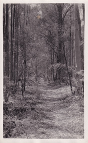
... lake kerferd...beechworth...The lake was named after George Briscoe Kerferd (1831–1889) who was responsible for Beechworth's water scheme. ...Obverse: Reverse: 8163/ Back track to Lake Kerford/ Beechworth/ Xmas 1941...It is also linked to political identity of George Briscoe Kerferd and the Beechworth Municipal Council. lake kerferd beechworth water scheme water reserve forest track forest pathway reservoir Legislative Assembly Hon. ...Taken on Christmas of 1941, shown is a track to Lake Kerferd with forest on both sides. The construction on Lake Kerferd began in 1862 however it wasn't completed until 1874 due to engineering and funding issues. The lake was named after George Briscoe Kerferd (1831–1889) who was responsible for Beechworth's water scheme. George Briscoe Kerferd was born on 21 January 1831 in Liverpool, England and arrived in Melbourne April 1853. He spent his first years in Australia in Bendigo before settling down in Beechworth as a wine and spirits merchant. He married Ann Martindale on 17th December 1853 at St James Cathedral, Melbourne and between them they had three sons and five daughters. Kerferd began his political and legal career in Beechworth when he was first elected to the Municipal Council in May 1857. Later he would be elected to the Legislative Assembly for the Ovens District in November 1864, and continued to represent the area until February 1886.This photograph is historically significant as it provides insight into surrounding areas of the water reserves of Victoria. It is also linked to political identity of George Briscoe Kerferd and the Beechworth Municipal Council.Black and white rectangular photograph printed on matte photographic paper.Obverse: Reverse: 8163/ Back track to Lake Kerford/ Beechworth/ Xmas 1941lake kerferd, beechworth, water scheme, water reserve, forest track, forest pathway, reservoir, legislative assembly, hon. george briscoe kerferd, catchments, beechworth water reserve, beechworth catchments, municipal council, st. james cathedral, lakes, reserve, water supply, political projects -
 The Beechworth Burke Museum
Photograph - Post Card, 1920-1930's
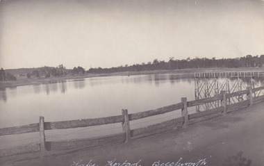
... Lake Kerferd...Beechworth...The lake was named after George Briscoe Kerferd (1831–1889) who was responsible for Beechworth's water scheme. ...Obverse: Lake Kerferd, Beechworth / Reverse: 8164 / Post Card / Correspondence / Address Only / Kodak Austral [Kodak Australia Stamp] /...The postcard holds Historic significance due to its connection to Beechworth and its Lake Kerford. It demonstrates the interactions between nature and colonialists, especially how the lake has somewhat been 'protected' with the man made fencing. ...Taken between 1920-1930s, shown is the banks of Lake Kerferd with wooden man-made fencing. The construction on Lake Kerferd began in 1862 however it wasn't completed until 1874 due to engineering and funding issues. The lake was named after George Briscoe Kerferd (1831–1889) who was responsible for Beechworth's water scheme. George Briscoe Kerferd was born on 21 January 1831 in Liverpool, England and arrived in Melbourne April 1853. He spent his first years in Australia in Bendigo before settling down in Beechworth as a wine and spirits merchant. He married Ann Martindale on 17th December 1853 at St James Cathedral, Melbourne and between them they had three sons and five daughters. Kerferd began his political and legal career in Beechworth when he was first elected to the Municipal Council in May 1857. Later he would be elected to the Legislative Assembly for the Ovens District in November 1864, and continued to represent the area until February 1886.The postcard holds Historic significance due to its connection to Beechworth and its Lake Kerford. It demonstrates the interactions between nature and colonialists, especially how the lake has somewhat been 'protected' with the man made fencing. It also presents information on the environmental development or degradation for the area, with possible changes to the environment that may have been caused by human physical forces, natural decay or Global Warming.Black and white rectangular postcard printed on paper.Obverse: Lake Kerferd, Beechworth / Reverse: 8164 / Post Card / Correspondence / Address Only / Kodak Austral [Kodak Australia Stamp] /lake kerferd, beechworth, water scheme, water reserve, reservoir, legislative assembly, hon. george briscoe kerferd, catchments, beechworth water reserve, beechworth catchments, municipal council, st. james cathedral, lakes, reserve, water supply, political projects, man-made fence, environmental changes -
 The Beechworth Burke Museum
Postcard
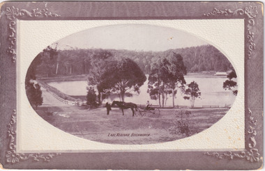
... ...Lake Kerford...Beechworth...Obverse: Lake Kerford / Beechworth Reverse: POST CARD / Stamp Here / Printed in Australia / This space may be used for Correspondence within the Commonwealth without extra postage / THIS SPACE IS FOR NAME AND ADDRESS / 84 - 108 - 1 / BMM3000...Lake Kerford, where an older man stands with a horse and small carriage. On top of the carriage sits a small child, and both face towards the camera to pose. Photograph does not state when it was captured, but possibly been taken c. 1920. The postcard holds Historic significance due to its connection to Beechworth ...Black and white photograph depicts wide shot of Lake Kerford, where an older man stands with a horse and small carriage. On top of the carriage sits a small child, and both face towards the camera to pose. Photograph does not state when it was captured, but possibly been taken c. 1920.The postcard holds Historic significance due to its connection to Beechworth and its Lake Kerford. It demonstrates the interactions between nature and current European residents, especially how the lake has somewhat been 'protected' with the man made fencing and road. It also presents information on the environmental development or degradation for the area, with possible changes to the environment that may have been caused by human physical forces, natural decay or Global Warming. The social significance is due to the connection between the postcard and the individuals in the photograph.Black and white oval photograph on rectangular postcard, printed on card.Obverse: Lake Kerford / Beechworth Reverse: POST CARD / Stamp Here / Printed in Australia / This space may be used for Correspondence within the Commonwealth without extra postage / THIS SPACE IS FOR NAME AND ADDRESS / 84 - 108 - 1 / BMM3000lakes, lake kerford, beechworth, postcard, horse drawn carriage -
 The Beechworth Burke Museum
Photograph
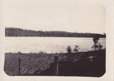
... ...Lake Kerford...Beechworth...Lake Kerford. Photograph does not state when it was captured, but possibly c1920. The photograph holds Historic significance due to the connection it holds to Beechworth and their local Lake Kerford. ...Black and white photograph depicts wide shot of Lake Kerford. Photograph does not state when it was captured, but possibly c1920.The photograph holds Historic significance due to the connection it holds to Beechworth and their local Lake Kerford. It demonstrates the interactions between nature and European residents, especially how the lake has been 'protected' by the man made fencing.Black and white oval photograph on rectangular postcard, printed on card.No inscriptions or markings found on either side of the postcard.lakes, lake kerford, beechworth, wire fencing, photograph -
 The Beechworth Burke Museum
Photograph - Post Card, Rose Series Stereograph Co. Postcard
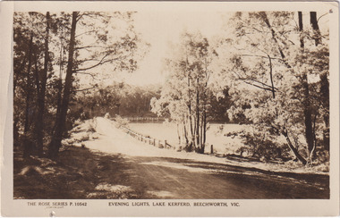
... Lake Kerferd...Beechworth...The lake was named after George Briscoe Kerferd (1831–1889) who was responsible for Beechworth's water scheme. ...Obverse: The Rose Series P. 10542 / Copyright / Evening lights, Lake Kerferd, Beechworth, VIC Reverse: Farley / Published by the Rose Stereograph Co., / Armadale Victoria. / 84-132-1 / Post card / The "Rose" Series De Luxe / A Real Photograph Produced in Australia / BMM299 ...The postcard holds Historic significance due to its connection to Beechworth and its Lake Kerford. It demonstrates the interactions between nature and colonialists, especially how the lake has somewhat been 'protected' with the man made fencing. ...The construction on Lake Kerferd began in 1862 however it wasn't completed until 1874 due to engineering and funding issues. The lake was named after George Briscoe Kerferd (1831–1889) who was responsible for Beechworth's water scheme. George Briscoe Kerferd was born on 21 January 1831 in Liverpool, England and arrived in Melbourne April 1853. He spent his first years in Australia in Bendigo before settling down in Beechworth as a wine and spirits merchant. He married Ann Martindale on 17th December 1853 at St James Cathedral, Melbourne and between them they had three sons and five daughters. Kerferd began his political and legal career in Beechworth when he was first elected to the Municipal Council in May 1857. Later he would be elected to the Legislative Assembly for the Ovens District in November 1864, and continued to represent the area until February 1886. The postcard holds Historic significance due to its connection to Beechworth and its Lake Kerford. It demonstrates the interactions between nature and colonialists, especially how the lake has somewhat been 'protected' with the man made fencing. It also presents information on the environmental development or degradation for the area, with possible changes to the environment that may have been caused by human physical forces, natural decay or Global Warming.Sepia rectangular postcard printed on paper.Obverse: The Rose Series P. 10542 / Copyright / Evening lights, Lake Kerferd, Beechworth, VIC Reverse: Farley / Published by the Rose Stereograph Co., / Armadale Victoria. / 84-132-1 / Post card / The "Rose" Series De Luxe / A Real Photograph Produced in Australia / BMM299 lake kerferd, beechworth, water scheme, water reserve, reservoir, legislative assembly, hon. george briscoe kerferd, catchments, beechworth water reserve, beechworth catchments, municipal council, st. james cathedral, lakes, reserve, water supply, political projects, rose series, postcard, rose series stereograph -
 The Beechworth Burke Museum
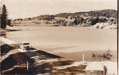
Photograph, 1960s
... beechworth catchments...Municipal Council...lakes...reserve...Water Supply...political projects...environmental changes...Mr. L. H. Sambell...Sambell...Rocky Mountain Mining Company...recreational lake...In the early 1920s, it was reconstructed as a recreational lake and was formally opened to public on 6 October 1928. The opening event was attended by townspeople and Beechworth's Minister of Lands Mr. ...Beechworth water scheme water reserve catchments Beechworth water reserve beechworth catchments Municipal Council lakes reserve Water Supply political projects environmental changes Mr. ...Taken around 1960s, this photograph shows the banks of Lake Sambell. Lake Sambell is named after Mr. L. H. Sambell who was instrumental in the lake's formation. Lake Sambell is the original site of the open sluice operation of Rocky Mountain Mining Company in the 1800s and the early 1900s. In the early 1920s, it was reconstructed as a recreational lake and was formally opened to public on 6 October 1928. The opening event was attended by townspeople and Beechworth's Minister of Lands Mr. Bailey. In the late 1930s to early 1940s, Lake Sambell redeveloped. The first development aimed to raise the banks by six feet to double its present area and to make the water cleaner. Another redevelopment in the 1940s was made possible by the Beechworth and District Progress Association. It involved raising the banks to five feet to provide swimming facilities, paddling pool and caravan park. This photograph holds Historic significance because of its connection to the development of Beechworth district.Sepia rectangular photograph printed on matte photographic paperObverse: Reverse: 3533 /beechworth, water scheme, water reserve, catchments, beechworth water reserve, beechworth catchments, municipal council, lakes, reserve, water supply, political projects, environmental changes, mr. l. h. sambell, sambell, rocky mountain mining company, recreational lake, minister of lands, mr. bailey, swimming pool, paddling pool, caravan park, swimming facilities, lake redevelopment, funding -
 The Beechworth Burke Museum
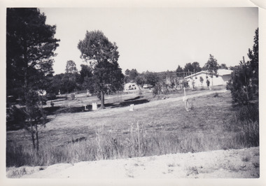
Photograph, 1960s
... lake caravan park...Caravan mid 20th century...beechworth...Lake Sambell Caravan Park opened in 1959 owing to the work of R.E. Carter, Beechworth Shire engineer from 1954-63. ...Lake Sambell Caravan Park opened in 1959 owing to the work of R.E. Carter, Beechworth Shire engineer from 1954-63. ...This photograph was taken in the 1960s at Lake Sambell Caravan Park, visible in the photograph are individual caravan sites with electricity outlets, a large single-story building, a parked car, and two caravans partially obstructed by trees. Lake Sambell Caravan Park opened in 1959 owing to the work of R.E. Carter, Beechworth Shire engineer from 1954-63. Carter advocated for improvements to the lake and surrounding area in order to encourage tourism in Beechworth. The opening of the caravan park was part of many improvements to Lake Sambell made in this period by Carter including: the swimming pool in 1961, water skiing and boating facilities, and increased lake surface in 1964. These improvements were financed mainly by grants from the Tourist Development Authority. The popularity of caravanning in Australia exploded during this post-war period of the late 1950s and 1960s. This popularity was driven by multiple factors, including: the stopping of fuel rations, the accessibility of car ownership through the manufacturing of affordable cars, technological developments in caravan design, and the increase in prosperity and leisure time for many Australians. Facilities such as electrical outlets to power caravans are present in this photograph of Lake Sambell Caravan Park. Lake Sambell is an artificial lake that was developed on the previous site of the Rocky Mountain Mining Company workings and was officially opened by Minister for Lands, Mr Baily, on October 5, 1928. The disused and unattractive remains of the mine were converted into a recreational area intended for swimming, boating, and fishing. The lake is named after Mr L.H. Sambell, shire engineer and secretary of the Forward Beechworth Committee, who advocated for the enhancement of Beechworth into a tourist destination and was central to the planning and establishment of the lake. This photograph is of historic and social significance in documenting the enhancement of the Lake Sambell area overseen by R.E. Carter and providing insight into caravanning during the 1960s in Australia. Caravanning was extremely popular in Australia during the late 1950s and 60s due to multiple social and economic factors including the stopping of fuel rations, the accessibility of car ownership through the manufacturing of affordable cars, technological developments in caravan design, and the increase in prosperity and leisure time for many Australians. Black and white rectangle photograph printed on photographic paper and unmounted.Reverse: 3538/ [logo back printing KODAK/ VELOX/ PAPER] / C798lake sambell caravan park, lake sambell, lake sambell 1960s, lake sambell fishing, lake sambell boating, lake sambell swimming pool, r.e. carter, l.h. sambell, tourist development authority, caravanning 1960s, caravan electricity outlets, caravan park, forward beechworth committee, rocky mountain mining company, lake caravan park, caravan mid 20th century, beechworth tourism, travel in the 1960s, holiday 1960s
