Showing 57 items matching "belford road, kew"
-
 Kew Historical Society Inc
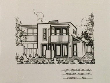
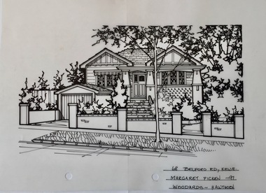
Drawing - Property Illustration, Margaret Picken, 9 Belford Road, Kew, 2001
... 9 Belford Road, Kew......9 belford road -- kew (vic.)...Pen and ink drawing on drafting film of 9 Belford Road, Kew by Margaret Picken....The year in which the drawing was created is also a valuable record for house historians, as a number of the properties depicted have either been altered since that date or demolished. artist -- margaret picken 1950- architectural drawings -- houses -- kew (vic.) 9 belford road -- kew (vic.) 9 BELFORD RD., KEW / MARGARET PICKEN 2001 / COLLINS SIMMS Pen and ink drawing on drafting film of 9 Belford Road, Kew by Margaret Picken. 9 Belford Road, Kew Drawing Property Illustration Margaret Picken Collins Simms ...After training as a Cartographic Draftsman within the mining industry, I worked as a property illustrator for real estate firms in the eastern suburbs of Melbourne for 23 years from 1983. I initially photographed houses with a Polaroid camera and made a 'thumbnail' sketch while there. The photos were used to scale off a sketch in pencil and then that sketch was overlaid with drafting film and the 'pen and ink' completed. The pens I used were the Rotring ‘Rapidigraph’ drafting pens. The ink was also made by Rotring (German).The film was ‘Rapidraw’, polyester drafting film, double matte. It takes a very fine line and doesn’t bleed. As well as house sketches, there were often floor plans and site plans ordered. Aerial sketches were ordered when the property needed an overall view. (Margaret Picken, 2020)This drawing is one of a series created by Margaret Picken for a range of real estate agents in Melbourne between c.1983 and c.2005. Each work is signed and dated by the artist.Gift of Margaret Picken, 2020Pen and ink drawing on drafting film of 9 Belford Road, Kew by Margaret Picken.9 BELFORD RD., KEW / MARGARET PICKEN 2001 / COLLINS SIMMSartist -- margaret picken 1950-, architectural drawings -- houses -- kew (vic.), 9 belford road -- kew (vic.) -
 Kew Historical Society Inc
Drawing - Property Illustration, Margaret Picken, 30 Belford Road, Kew East, 1990
... 30 Belford Road, Kew East.......30 belford road - kew east (vic)....Pen and ink drawing on drafting film of 30 Belford Road, Kew by Margaret Picken....The year in which the drawing was created is also a valuable record for house historians, as a number of the properties depicted have either been altered since that date or demolished. artist -- margaret picken 1950- architectural drawings -- houses -- kew (vic.) 30 belford road - kew east (vic). 30 BELFORD RD., KEW / MARGARET PICKEN '90 / WOODARDS ~ KEW Pen and ink drawing on drafting film of 30 Belford Road, Kew by Margaret Picken. 30 Belford Road, Kew East. ...After training as a Cartographic Draftsman within the mining industry, I worked as a property illustrator for real estate firms in the eastern suburbs of Melbourne for 23 years from 1983. I initially photographed houses with a Polaroid camera and made a 'thumbnail' sketch while there. The photos were used to scale off a sketch in pencil and then that sketch was overlaid with drafting film and the 'pen and ink' completed. The pens I used were the Rotring ‘Rapidigraph’ drafting pens. The ink was also made by Rotring (German).The film was ‘Rapidraw’, polyester drafting film, double matte. It takes a very fine line and doesn’t bleed. As well as house sketches, there were often floor plans and site plans ordered. Aerial sketches were ordered when the property needed an overall view. (Margaret Picken, 2020)This drawing is one of a series created by Margaret Picken for a range of real estate agents in Melbourne between c.1983 and c.2005. Each work is signed and dated by the artist.Gift of Margaret Picken, 2020Pen and ink drawing on drafting film of 30 Belford Road, Kew by Margaret Picken.30 BELFORD RD., KEW / MARGARET PICKEN '90 / WOODARDS ~ KEWartist -- margaret picken 1950-, architectural drawings -- houses -- kew (vic.), 30 belford road - kew east (vic). -
 Kew Historical Society Inc
Drawing - Property Illustration, Margaret Picken, 28 Belford Road, Kew East, 1998
... 28 Belford Road, Kew East.......28 belford road - kew east (vic)....Pen and ink drawing on drafting film of 28 Belford Road, Kew by Margaret Picken....The year in which the drawing was created is also a valuable record for house historians, as a number of the properties depicted have either been altered since that date or demolished. artist -- margaret picken 1950- architectural drawings -- houses -- kew (vic.) 28 belford road - kew east (vic). 28 BELFORD RD., KEW / MARGARET PICKEN '98/ WOODARDS ~ HAWTHORN Pen and ink drawing on drafting film of 28 Belford Road, Kew by Margaret Picken. 28 Belford Road, Kew East. ...After training as a Cartographic Draftsman within the mining industry, I worked as a property illustrator for real estate firms in the eastern suburbs of Melbourne for 23 years from 1983. I initially photographed houses with a Polaroid camera and made a 'thumbnail' sketch while there. The photos were used to scale off a sketch in pencil and then that sketch was overlaid with drafting film and the 'pen and ink' completed. The pens I used were the Rotring ‘Rapidigraph’ drafting pens. The ink was also made by Rotring (German).The film was ‘Rapidraw’, polyester drafting film, double matte. It takes a very fine line and doesn’t bleed. As well as house sketches, there were often floor plans and site plans ordered. Aerial sketches were ordered when the property needed an overall view. (Margaret Picken, 2020)This drawing is one of a series created by Margaret Picken for a range of real estate agents in Melbourne between c.1983 and c.2005. Each work is signed and dated by the artist.Gift of Margaret Picken, 2020Pen and ink drawing on drafting film of 28 Belford Road, Kew by Margaret Picken.28 BELFORD RD., KEW / MARGARET PICKEN '98/ WOODARDS ~ HAWTHORNartist -- margaret picken 1950-, architectural drawings -- houses -- kew (vic.), 28 belford road - kew east (vic). -
 Kew Historical Society Inc
Drawing - Property Illustration, Margaret Picken, 96 Belford Road, Kew East, 1987
... 96 Belford Road, Kew East.......96 belford road - kew east (vic)....Pen and ink drawing on drafting film of 96 Belford Road, Kew by Margaret Picken....The year in which the drawing was created is also a valuable record for house historians, as a number of the properties depicted have either been altered since that date or demolished. artist -- margaret picken 1950- architectural drawings -- houses -- kew (vic.) 96 belford road - kew east (vic). 96 BELFORD RD., KEW / MARG PICKEN '87 Pen and ink drawing on drafting film of 96 Belford Road, Kew by Margaret Picken. 96 Belford Road, Kew East. ...After training as a Cartographic Draftsman within the mining industry, I worked as a property illustrator for real estate firms in the eastern suburbs of Melbourne for 23 years from 1983. I initially photographed houses with a Polaroid camera and made a 'thumbnail' sketch while there. The photos were used to scale off a sketch in pencil and then that sketch was overlaid with drafting film and the 'pen and ink' completed. The pens I used were the Rotring ‘Rapidigraph’ drafting pens. The ink was also made by Rotring (German).The film was ‘Rapidraw’, polyester drafting film, double matte. It takes a very fine line and doesn’t bleed. As well as house sketches, there were often floor plans and site plans ordered. Aerial sketches were ordered when the property needed an overall view. (Margaret Picken, 2020)This drawing is one of a series created by Margaret Picken for a range of real estate agents in Melbourne between c.1983 and c.2003. Each work is signed and dated by the artist.Gift of Margaret Picken, 2020Pen and ink drawing on drafting film of 96 Belford Road, Kew by Margaret Picken.96 BELFORD RD., KEW / MARG PICKEN '87artist -- margaret picken 1950-, architectural drawings -- houses -- kew (vic.), 96 belford road - kew east (vic). -
 Kew Historical Society Inc
Drawing - Property Illustration, Margaret Picken, 4/31 Belford Road, Kew, 1994
... 4/31 Belford Road, Kew......4/31 belford road -- kew (vic.)...Pen and ink drawing on drafting film of 4/31 Belford Road, Kew by Margaret Picken....The year in which the drawing was created is also a valuable record for house historians, as a number of the properties depicted have either been altered since that date or demolished. artist -- margaret picken 1950- architectural drawings -- houses -- kew (vic.) 4/31 belford road -- kew (vic.) 4/31 BELFORD RD., KEW / MARGARET PICKEN '94/ WOODARDS ~ KEW Pen and ink drawing on drafting film of 4/31 Belford Road, Kew by Margaret Picken. 4/31 Belford Road, Kew Drawing Property Illustration Margaret Picken Woodards (Kew) ...After training as a Cartographic Draftsman within the mining industry, I worked as a property illustrator for real estate firms in the eastern suburbs of Melbourne for 23 years from 1983. I initially photographed houses with a Polaroid camera and made a 'thumbnail' sketch while there. The photos were used to scale off a sketch in pencil and then that sketch was overlaid with drafting film and the 'pen and ink' completed. The pens I used were the Rotring ‘Rapidigraph’ drafting pens. The ink was also made by Rotring (German).The film was ‘Rapidraw’, polyester drafting film, double matte. It takes a very fine line and doesn’t bleed. As well as house sketches, there were often floor plans and site plans ordered. Aerial sketches were ordered when the property needed an overall view. (Margaret Picken, 2020)This drawing is one of a series created by Margaret Picken for a range of real estate agents in Melbourne between c.1983 and c.2005. Each work is signed and dated by the artist.Gift of Margaret Picken, 2020Pen and ink drawing on drafting film of 4/31 Belford Road, Kew by Margaret Picken.4/31 BELFORD RD., KEW / MARGARET PICKEN '94/ WOODARDS ~ KEWartist -- margaret picken 1950-, architectural drawings -- houses -- kew (vic.), 4/31 belford road -- kew (vic.) -
 Kew Historical Society Inc
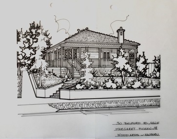
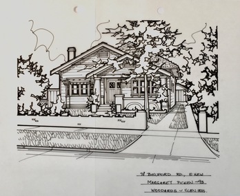
Drawing - Property Illustration, Margaret Picken, 30 Belford Road, Kew East, 1998
... 30 Belford Road, Kew East......30 belford road - kew east (vic)...Pen and ink drawing on drafting film of 30 Belford Road, Kew East by Margaret Picken....The year in which the work was created is also a valuable record for house historians, as a number of the properties depicted have either been altered since that date or demolished. artist -- margaret picken 1950- property illustrations — buildings — kew east (vic.) 30 belford road - kew east (vic) 30 BELFORD RD., KEW E. / MARGARET PICKEN ~98 / WOODARDS ~ HAWTHORN Pen and ink drawing on drafting film of 30 Belford Road, Kew East by Margaret Picken. 30 Belford Road, Kew East Drawing Property Illustration Margaret Picken Woodards (Hawthorn) ...After training as a Cartographic Draftsman within the mining industry, I worked as a property illustrator for real estate firms in the eastern suburbs of Melbourne for 23 years from 1983. I initially photographed houses with a Polaroid camera and made a 'thumbnail' sketch while there. The photos were used to scale off a sketch in pencil and then that sketch was overlaid with drafting film and the 'pen and ink' completed. The pens I used were the Rotring ‘Rapidigraph’ drafting pens. The ink was also made by Rotring (German).The film was ‘Rapidraw’, polyester drafting film, double matte. It takes a very fine line and doesn’t bleed. As well as house sketches, there were often floor plans and site plans ordered. Aerial sketches were ordered when the property needed an overall view. (Margaret Picken, 2020)This drawing is one of a series created by Margaret Picken for real estate agents in Melbourne between 1983 and 2006. Each work is signed and dated by the artist.Gift of Margaret Picken, 2020Pen and ink drawing on drafting film of 30 Belford Road, Kew East by Margaret Picken.30 BELFORD RD., KEW E. / MARGARET PICKEN ~98 / WOODARDS ~ HAWTHORNartist -- margaret picken 1950-, property illustrations — buildings — kew east (vic.), 30 belford road - kew east (vic) -
 Kew Historical Society Inc
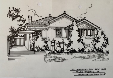
Drawing - Property Illustration, Margaret Picken, 40 Belford Road, Kew East, 1988
... 40 Belford Road, Kew East......40 belford road - kew east (vic)...Pen and ink drawing on drafting film of 40 Belford Road, Kew East by Margaret Picken....PICKEN '88 / WOODARDS ~ BALWYN - 'B' Pen and ink drawing on drafting film of 40 Belford Road, Kew East by Margaret Picken. 40 Belford Road, Kew East Drawing Property Illustration Margaret Picken Woodards (Balwyn) ...After training as a Cartographic Draftsman within the mining industry, I worked as a property illustrator for real estate firms in the eastern suburbs of Melbourne for 23 years from 1983. I initially photographed houses with a Polaroid camera and made a 'thumbnail' sketch while there. The photos were used to scale off a sketch in pencil and then that sketch was overlaid with drafting film and the 'pen and ink' completed. The pens I used were the Rotring ‘Rapidigraph’ drafting pens. The ink was also made by Rotring (German).The film was ‘Rapidraw’, polyester drafting film, double matte. It takes a very fine line and doesn’t bleed. As well as house sketches, there were often floor plans and site plans ordered. Aerial sketches were ordered when the property needed an overall view. (Margaret Picken, 2020)This drawing is one of a series created by Margaret Picken for real estate agents in Melbourne between 1983 and 2006. Each work is signed and dated by the artist.Gift of Margaret Picken, 2020Pen and ink drawing on drafting film of 40 Belford Road, Kew East by Margaret Picken.40 BELFORD RD., KEW EAST/ MARG. PICKEN '88 / WOODARDS ~ BALWYN - 'B'artist -- margaret picken 1950-, property illustrations — buildings — kew east (vic.), 40 belford road - kew east (vic) -
 Kew Historical Society Inc
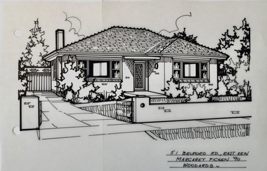
Drawing - Property Illustration, Margaret Picken, 51 Belford Road, Kew East, 1990
... 51 Belford Road, Kew East......52 belford road - kew east (vic)...Pen and ink drawing on drafting film of 51 Belford Road, Kew East by Margaret Picken....The year in which the work was created is also a valuable record for house historians, as a number of the properties depicted have either been altered since that date or demolished. artist -- margaret picken 1950- property illustrations — buildings — kew east (vic.) 52 belford road - kew east (vic) 51 BELFORD RD., EAST KEW / MARGARET PICKEN '90 / WOODARDS ~ Pen and ink drawing on drafting film of 51 Belford Road, Kew East by Margaret Picken. 51 Belford Road, Kew East Drawing Property Illustration Margaret Picken Woodards ...After training as a Cartographic Draftsman within the mining industry, I worked as a property illustrator for real estate firms in the eastern suburbs of Melbourne for 23 years from 1983. I initially photographed houses with a Polaroid camera and made a 'thumbnail' sketch while there. The photos were used to scale off a sketch in pencil and then that sketch was overlaid with drafting film and the 'pen and ink' completed. The pens I used were the Rotring ‘Rapidigraph’ drafting pens. The ink was also made by Rotring (German).The film was ‘Rapidraw’, polyester drafting film, double matte. It takes a very fine line and doesn’t bleed. As well as house sketches, there were often floor plans and site plans ordered. Aerial sketches were ordered when the property needed an overall view. (Margaret Picken, 2020)This drawing is one of a series created by Margaret Picken for real estate agents in Melbourne between 1983 and 2006. Each work is signed and dated by the artist.Gift of Margaret Picken, 2020Pen and ink drawing on drafting film of 51 Belford Road, Kew East by Margaret Picken.51 BELFORD RD., EAST KEW / MARGARET PICKEN '90 / WOODARDS ~ artist -- margaret picken 1950-, property illustrations — buildings — kew east (vic.), 52 belford road - kew east (vic) -
 Kew Historical Society Inc
Drawing - Property Illustration, Margaret Picken, 68 Belford Road, Kew East, 1997
... 68 Belford Road, Kew East......68 belford road - kew east (vic)...Pen and ink drawing on drafting film of 68 Belford Road, Kew East by Margaret Picken....The year in which the work was created is also a valuable record for house historians, as a number of the properties depicted have either been altered since that date or demolished. artist -- margaret picken 1950- property illustrations — buildings — kew east (vic.) 68 belford road - kew east (vic) 68 BELFORD RD., KEW E. / MARGARET PICKEN ~97 / WOODARDS ~ HAWTHORN Pen and ink drawing on drafting film of 68 Belford Road, Kew East by Margaret Picken. 68 Belford Road, Kew East Drawing Property Illustration Margaret Picken Woodards (Hawthorn) ...After training as a Cartographic Draftsman within the mining industry, I worked as a property illustrator for real estate firms in the eastern suburbs of Melbourne for 23 years from 1983. I initially photographed houses with a Polaroid camera and made a 'thumbnail' sketch while there. The photos were used to scale off a sketch in pencil and then that sketch was overlaid with drafting film and the 'pen and ink' completed. The pens I used were the Rotring ‘Rapidigraph’ drafting pens. The ink was also made by Rotring (German).The film was ‘Rapidraw’, polyester drafting film, double matte. It takes a very fine line and doesn’t bleed. As well as house sketches, there were often floor plans and site plans ordered. Aerial sketches were ordered when the property needed an overall view. (Margaret Picken, 2020)This drawing is one of a series created by Margaret Picken for real estate agents in Melbourne between 1983 and 2006. Each work is signed and dated by the artist.Gift of Margaret Picken, 2020Pen and ink drawing on drafting film of 68 Belford Road, Kew East by Margaret Picken.68 BELFORD RD., KEW E. / MARGARET PICKEN ~97 / WOODARDS ~ HAWTHORNartist -- margaret picken 1950-, property illustrations — buildings — kew east (vic.), 68 belford road - kew east (vic) -
 Kew Historical Society Inc
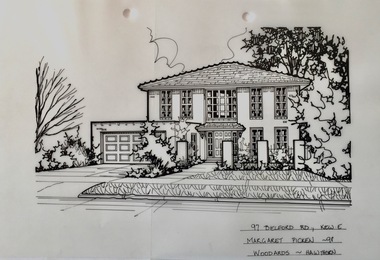
Drawing - Property Illustration, Margaret Picken, 78 Belford Road, Kew East, 1993
... 78 Belford Road, Kew East......78 belford road - kew east (vic)...Pen and ink drawing on drafting film of 78 Belford Road, Kew East by Margaret Picken....The year in which the work was created is also a valuable record for house historians, as a number of the properties depicted have either been altered since that date or demolished. artist -- margaret picken 1950- property illustrations — buildings — kew east (vic.) 78 belford road - kew east (vic) 78 BELFORD RD., E.KEW / MARGARET PICKEN ~93 / WOODARDS ~ GLEN IRIS Pen and ink drawing on drafting film of 78 Belford Road, Kew East by Margaret Picken. 78 Belford Road, Kew East Drawing Property Illustration Margaret Picken Woodards (Glen Iris) ...After training as a Cartographic Draftsman within the mining industry, I worked as a property illustrator for real estate firms in the eastern suburbs of Melbourne for 23 years from 1983. I initially photographed houses with a Polaroid camera and made a 'thumbnail' sketch while there. The photos were used to scale off a sketch in pencil and then that sketch was overlaid with drafting film and the 'pen and ink' completed. The pens I used were the Rotring ‘Rapidigraph’ drafting pens. The ink was also made by Rotring (German).The film was ‘Rapidraw’, polyester drafting film, double matte. It takes a very fine line and doesn’t bleed. As well as house sketches, there were often floor plans and site plans ordered. Aerial sketches were ordered when the property needed an overall view. (Margaret Picken, 2020)This drawing is one of a series created by Margaret Picken for real estate agents in Melbourne between 1983 and 2006. Each work is signed and dated by the artist.Gift of Margaret Picken, 2020Pen and ink drawing on drafting film of 78 Belford Road, Kew East by Margaret Picken.78 BELFORD RD., E.KEW / MARGARET PICKEN ~93 / WOODARDS ~ GLEN IRISartist -- margaret picken 1950-, property illustrations — buildings — kew east (vic.), 78 belford road - kew east (vic) -
 Kew Historical Society Inc
Drawing - Property Illustration, Margaret Picken, 90 Belford Road, Kew East, 1998
... 90 Belford Road, Kew East......90 belford road - kew east (vic)...Pen and ink drawing on drafting film of 90 Belford Road, Kew East by Margaret Picken....The year in which the work was created is also a valuable record for house historians, as a number of the properties depicted have either been altered since that date or demolished. artist -- margaret picken 1950- property illustrations — buildings — kew east (vic.) 90 belford road - kew east (vic) 90 BELFORD RD., KEW E. / MARGARET PICKEN ~98 / WOODARDS ~ HAWTHORN Pen and ink drawing on drafting film of 90 Belford Road, Kew East by Margaret Picken. 90 Belford Road, Kew East Drawing Property Illustration Margaret Picken Woodards (Hawthorn) ...After training as a Cartographic Draftsman within the mining industry, I worked as a property illustrator for real estate firms in the eastern suburbs of Melbourne for 23 years from 1983. I initially photographed houses with a Polaroid camera and made a 'thumbnail' sketch while there. The photos were used to scale off a sketch in pencil and then that sketch was overlaid with drafting film and the 'pen and ink' completed. The pens I used were the Rotring ‘Rapidigraph’ drafting pens. The ink was also made by Rotring (German).The film was ‘Rapidraw’, polyester drafting film, double matte. It takes a very fine line and doesn’t bleed. As well as house sketches, there were often floor plans and site plans ordered. Aerial sketches were ordered when the property needed an overall view. (Margaret Picken, 2020)This drawing is one of a series created by Margaret Picken for real estate agents in Melbourne between 1983 and 2006. Each work is signed and dated by the artist.Gift of Margaret Picken, 2020Pen and ink drawing on drafting film of 90 Belford Road, Kew East by Margaret Picken.90 BELFORD RD., KEW E. / MARGARET PICKEN ~98 / WOODARDS ~ HAWTHORNartist -- margaret picken 1950-, property illustrations — buildings — kew east (vic.), 90 belford road - kew east (vic) -
 Surrey Hills Historical Society Collection
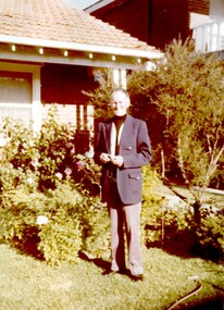
Photograph, John Reaburn outside his home, 92 Belford Road, Kew
... John Reaburn outside his home, 92 Belford Road, Kew......92 belford road kew...According to his grandson Peter Reaburn, this photo was taken outside John's home at 92 Belford Road, Kew where his son Robert John (1930-) spent his childhood and youth....John Reaburn outside his home, 92 Belford Road, Kew Photograph Photograph ...John Colin Reaburn, also known as Jack, (1899 -1987) was an accountant by profession and an early contributor to the historical collection. He was also an active member of the Surrey Hills Progress Association. According to his grandson Peter Reaburn, this photo was taken outside John's home at 92 Belford Road, Kew where his son Robert John (1930-) spent his childhood and youth.John Reaburn was a key figure in the establishment of the Surrey Hills history collection.A coloured photograph of a man standing in a front garden. He is wearing a navy sports coat, light coloured trousers, and a black skivvy.surrey hills, history collection, surrey hills state school, accountant, 1978, clothing and dress, mr john colin reaburn, mr john reaburn, mr jack reaburn, 92 belford road kew -
 Kew Historical Society Inc
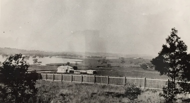
Photograph, Wade's Farm, Kilby Road, Nineteenth Century
... kew)...kilby road...north kew...belford...Belford, near Kew) is undulating ground, with a remarkably heavy crop of wheat upon it. This, taken in connection with, the state of the ground, still soft from the recent rains, made the trial an uncommonly severe one. ..."(South Australian Advertiser, 15 January 1859) Some bricks used in Kew buildings came from the brickworks on Wade's Farm at the end of Belford Road near the Yarra River (now part of the Kew Golf Club). ...(History of RSL by John Torpey) wade's farm farming (kew) kilby road north kew belford road, kew kew golf club Wade's Farm, Kilby Road, Kew. ...""The public trial of reaping machines, under the auspices of the Port Phillip Farmers' Society, advertised to take place on Friday, last, but postponed on account of the weather, came off December 27. The place selected (Mr. Wade's farm, Belford, near Kew) is undulating ground, with a remarkably heavy crop of wheat upon it. This, taken in connection with, the state of the ground, still soft from the recent rains, made the trial an uncommonly severe one. ..."(South Australian Advertiser, 15 January 1859) Some bricks used in Kew buildings came from the brickworks on Wade's Farm at the end of Belford Road near the Yarra River (now part of the Kew Golf Club). (History of RSL by John Torpey)Wade's Farm, Kilby Road, Kew.wade's farm, farming (kew), kilby road, north kew, belford road, kew, kew golf club -
 Kew Historical Society Inc
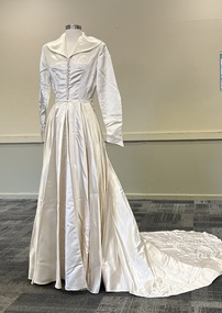
Clothing - Satin Wedding Dress, 1952
... Wedding dress made for Margaret Coleman of 135 Belford Road, Kew, who married Murray Turnbull of 21 Molesworth Street, Kew, at St Andrew’s, Gardiner in October 1952....Kew Historical Society Inc Kew Court House 188 High Street Kew melbourne Wedding dress made for Margaret Coleman of 135 Belford Road, Kew, who married Murray Turnbull of 21 Molesworth Street, Kew, at St Andrew’s, Gardiner in October 1952. ...Wedding dress made for Margaret Coleman of 135 Belford Road, Kew, who married Murray Turnbull of 21 Molesworth Street, Kew, at St Andrew’s, Gardiner in October 1952.White silk satin wedding dress made by Buckley & Nunn of Collins Street Melbourne. The dress has long sleeves and a v-neck bordered by wide lapels. The bodice is buttoned to the waist with buttons covered in the same fabric as the gown. The skirt drops from the waist with gentle pleating at the front. The skirt features a very long and wide train."Fabric exclusive to Buckley & Nunn"fashion and design -- 1950s, wedding dresses -
![Wal Ives & Bert [Watson] at the outlet of the Kew Main Drain](/media/collectors/550653872162f11fb04854aa/items/61593ef27608a87f688412b1/item-media/61594a5a7608a87f68848c29/item-fit-380x285.jpg?cb=6) Kew Historical Society Inc
Kew Historical Society IncPhotograph - Wal Ives & Bert [Watson] at the outlet of the Kew Main Drain, c.1900
... kew (vic)...wal ives...albert watson...belford road...As the creek ran through Kew it cut across a number of roads the maintenance of which was a continuing concern for Kew Councillors. In August 1864, the Council called for tenders to erect a stone culvert and embankment over Connor's Creek, on Belford-road. ...This may be the embankment on which the boys are sitting. connors creek -- kew (vic) wal ives albert watson belford road yarra river -- kew (vic.) creeks -- kew (vic.) drains -- kew (vic.) ...Connor's Creek is/was one of two major waterways bisecting Kew, both of which empty into the Yarra River. Connor's Creek originates near the grounds of Genazzano FCJ College, which is one of the highest points in Kew. Until the 1930s, this was an open creek until a barrel drain - the Kew Main Drain - was constructed. As the creek ran through Kew it cut across a number of roads the maintenance of which was a continuing concern for Kew Councillors. In August 1864, the Council called for tenders to erect a stone culvert and embankment over Connor's Creek, on Belford-road. This may be the embankment on which the boys are sitting.Original, small photographic positive on card of two boys, identified by the donor as 'Wal Ives and Bert' [Albert Watson] sitting on bluestone capping above an outlet of Connor's Creek. To the left of the boys is a barrel drain which at that stage was the outlet for Connor's Creek near the Yarra River. The retaining wall is constructed of brick. In ink on photo: "Wal & Bert"connors creek -- kew (vic), wal ives, albert watson, belford road, yarra river -- kew (vic.), creeks -- kew (vic.), drains -- kew (vic.) -
 Melbourne Tram Museum
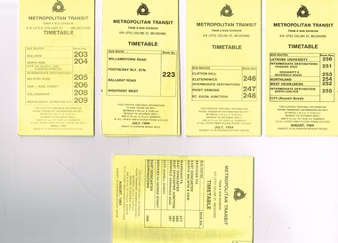
Ephemera - Timetable/s, Metropolitan Transit Authority (MTA), "MMTB Bus Timetables", 1984
... All printed on yellow paper unless noted otherwise. .1 - Route 203, 204, 205, 206, 208. 209 - Bulleen, North Kew, Belford Road, Kew, Collingwood and Nicholson and Johnson St - City - April 1984 .2 - Route 223 - Williamstown Road, Footscray Railway Station, Ballarat Road and Highpoint West - July 1984 .3 - Route 246, 247, 248 - Clifton Hill, Elsternwick, Point Ormond and St Kilda Junction - July 1984 .4 - Route 256, 251, 253, 254, 252, 255 - Latrobe University, Northland, West Heidelberg - City - Aug./ 1984 .5 - Route 277, 280, 299. 281 and 268 - services via East Doncaster, North Balwyn and Kew - Warrandyte, Donvale, Shoppingtown - August 1984...Melbourne Tram Museum 8 Wallen Road Hawthorn melbourne Trams tramways Metropolitan Transit Timetables Melbourne Fares Buses Footscray Latrobe University Northland Heidelberg Warrandyte Doncaster Donvale Bulleen North Kew Williamstown Rd Highpoint Clifton Hill Elsternwick Point Ormond St Kilda Junction Set of 5 Metropolitan Transit Bus timetables, folded sheets, generally 8 or 10 sections, providing timetables for specific routes, day of week giving information on tram times at specific time points, route map, sections and fares and organisation address - 616 Little Collins St. Melbourne. All printed on yellow paper unless noted otherwise. .1 - Route 203, 204, 205, 206, 208. 209 - Bulleen, North Kew, Belford ...Set of 5 Metropolitan Transit Bus timetables, folded sheets, generally 8 or 10 sections, providing timetables for specific routes, day of week giving information on tram times at specific time points, route map, sections and fares and organisation address - 616 Little Collins St. Melbourne. All printed on yellow paper unless noted otherwise. .1 - Route 203, 204, 205, 206, 208. 209 - Bulleen, North Kew, Belford Road, Kew, Collingwood and Nicholson and Johnson St - City - April 1984 .2 - Route 223 - Williamstown Road, Footscray Railway Station, Ballarat Road and Highpoint West - July 1984 .3 - Route 246, 247, 248 - Clifton Hill, Elsternwick, Point Ormond and St Kilda Junction - July 1984 .4 - Route 256, 251, 253, 254, 252, 255 - Latrobe University, Northland, West Heidelberg - City - Aug./ 1984 .5 - Route 277, 280, 299. 281 and 268 - services via East Doncaster, North Balwyn and Kew - Warrandyte, Donvale, Shoppingtown - August 1984trams, tramways, metropolitan transit, timetables, melbourne, fares, buses, footscray, latrobe university, northland, heidelberg, warrandyte, doncaster, donvale, bulleen, north kew, williamstown rd, highpoint, clifton hill, elsternwick, point ormond, st kilda junction -
 Melbourne Tram Museum
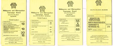
Ephemera - Timetable/s, Metropolitan Transit Authority (MTA), "MMTB Bus Timetables", 1982
... All printed on yellow paper unless noted otherwise. .1 - Routes 19, 20, 18 - North Coburg, and bus service to Fawkner, Gowrie, Upfield - nightly Monday to Saturday and all day Sunday - Oct. 1982 .2 - Route 48, 24, 40, 41, 29 - North Balwyn - City - March 1982 .3 - Route 55, 56 68 - Sunday only via Elizabeth St - March 1982 .4 - Route 276, 278 and 279 - Services via Templestowe, Warrandyte and Newmans Road - City - July 1982 .5 - Route 57, 357 (bus Sundays only), 54, 60, 58, 50 - West Maribyrnong - City - Jan. 1982 .6 - Route 59, 49, 52, 51 and 81 - Essendon Airport - City - March 1982 .7 - Route 203, 204, 205, 206, 208. 209 - Bulleen, North Kew, Belford Road, Kew, Collingwood and Nicholson and Johnson St - City - Sept. 1982...All printed on yellow paper unless noted otherwise. .1 - Routes 19, 20, 18 - North Coburg, and bus service to Fawkner, Gowrie, Upfield - nightly Monday to Saturday and all day Sunday - Oct. 1982 .2 - Route 48, 24, 40, 41, 29 - North Balwyn - City - March 1982 .3 - Route 55, 56 68 - Sunday only via Elizabeth St - March 1982 .4 - Route 276, 278 and 279 - Services via Templestowe, Warrandyte and Newmans Road - City - July 1982 .5 - Route 57, 357 (bus Sundays only), 54, 60, 58, 50 - West Maribyrnong - City - Jan. 1982 .6 - Route 59, 49, 52, 51 and 81 - Essendon Airport - City - March 1982 .7 - Route 203, 204, 205, 206, 208. 209 - Bulleen, North Kew, Belford Road, Kew, Collingwood and Nicholson and Johnson St - City - Sept. 1982 "MMTB Bus Timetables" Ephemera Timetable/s Metropolitan Transit Authority (MTA) ...Set of 7 MMTB Tram and Bus timetables, folded sheets, generally 8 or 10 sections, providing timetables for specific routes, day of week giving information on tram times at specific time points, route map, sections and fares and organisation address - 616 Little Collins St. Melbourne. All printed on yellow paper unless noted otherwise. .1 - Routes 19, 20, 18 - North Coburg, and bus service to Fawkner, Gowrie, Upfield - nightly Monday to Saturday and all day Sunday - Oct. 1982 .2 - Route 48, 24, 40, 41, 29 - North Balwyn - City - March 1982 .3 - Route 55, 56 68 - Sunday only via Elizabeth St - March 1982 .4 - Route 276, 278 and 279 - Services via Templestowe, Warrandyte and Newmans Road - City - July 1982 .5 - Route 57, 357 (bus Sundays only), 54, 60, 58, 50 - West Maribyrnong - City - Jan. 1982 .6 - Route 59, 49, 52, 51 and 81 - Essendon Airport - City - March 1982 .7 - Route 203, 204, 205, 206, 208. 209 - Bulleen, North Kew, Belford Road, Kew, Collingwood and Nicholson and Johnson St - City - Sept. 1982trams, tramways, mmtb, timetables, melbourne, fares, buses, bus replacement, trams, upfield, route 18, route 19, route 20, route 24, route 29, route 40, route 41, route 48, route 49, route 50, route 52, route 51, route 54, route 55, route 56, route 57, route 58, route 59, route 60, route 68, route 81, route 357, warrandyte, doncaster, templestowe, kew -
 Kew Historical Society Inc
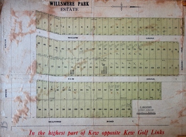
Plan - Subdivision Plan, J R Mathers & McMillan, Willsmere Park Estate, c.1940
... Annotations on the plan indicate that the more expensive lots faced Belford Road opposite the Kew Golf Links. Two of these sold for £310. ...Kew. The balance of the Estate, and the largest proportion of allotments was to be subdivided and sold from 1940. This second sale included 109 lots fronting Kilby Road and Elm and Willow Groves. Annotations on the plan indicate that the more expensive lots faced Belford ...Pru Sanderson, in her groundbreaking ‘City of Kew Urban Conservation Study : Volume 2 - Development History’ (1988), summarised the periods of urban development and subdivisions of land in Kew. The periods that she identified included 1845-1880, 1880-1893, 1893-1921, 1921-1933, 1933-1943, and Post-War Development. These periods were selected as they represented periods of rapid growth or decline in urban development. An obvious starting point for Sanderson’s groupings involved population growth and the associated economic cycles. These cycles also highlighted urban expansion onto land that was predominantly rural, although in other cases it represented the decline and breakup of large estates. A number of the plans in the Kew Historical Society’s collection can also be found in other collections, such as those of the State Library of Victoria and the Boroondara Library Service. A number are however unique to the collection.The Kew Historical Society collection includes almost 100 subdivision plans pertaining to suburbs of the City of Melbourne. Most of these are of Kew, Kew East or Studley Park, although a smaller number are plans of Camberwell, Deepdene, Balwyn and Hawthorn. It is believed that the majority of the plans were gifted to the Society by persons connected with the real estate firm - J. R. Mathers and McMillan, 136 Cotham Road, Kew. The Plans in the collection are rarely in pristine form, being working plans on which the agent would write notes and record lots sold and the prices of these. The subdivision plans are historically significant examples of the growth of urban Melbourne from the beginning of the 20th Century up until the 1980s. A number of the plans are double-sided and often include a photograph on the reverse. A number of the latter are by noted photographers such as J.E. Barnes. In 1910, the Willsmere Park Estate Dairy was lauded in the Box Hill Reporter as ‘an object lesson in dairying’. Ten years later, in 1923, it was to be sold. The first subdivision of the Estate included 77 grand allotments with frontages to Belford and Kilby Roads, Elm and Willow Groves, and Acacia Avenue. Every lot was claimed to be ‘high and dry’, and with panoramic views of Kew and East Kew. The balance of the Estate, and the largest proportion of allotments was to be subdivided and sold from 1940. This second sale included 109 lots fronting Kilby Road and Elm and Willow Groves. Annotations on the plan indicate that the more expensive lots faced Belford Road opposite the Kew Golf Links. Two of these sold for £310. Lots further to the west in Willow Grove were sold for £60 less. Many of the houses to be built on these 109 allotments after the War faced Government restrictions on building materials and the dimensions of each house due to postwar shortages.subdivision plans - east kew, willsmere park estate -
 Melbourne Tram Museum
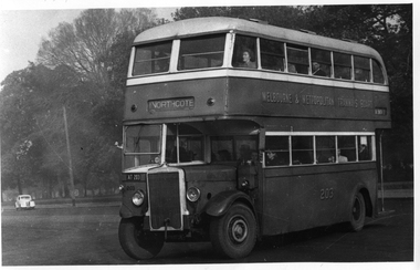
Photograph - Set of 11 Black and White photograph, Ken Flood, 18/04/1974 12:00:00 AM
... Late 1940's photo. .8 - Bus No 143 1940 Leyland TS8c drop enter - in Russell Street at LaTrobe Street bound for North Kew. (Belford Road via Collingwood). Photo not dated. .9 - Bus No 9 1938 Leyland Cub (diesel) with Preston Workshops body. - in Russell Street at LaTrobe Street bound for North Carlton .10 - Bus No 4 1938 Leyland Cub (Diesel) with Preston Workshops body - in Lonsdale Street at William Street. note destination not reset for the return trip. .11 - Bus No 150 1940 Leyland TS11c Drop enter - Nicholson Street at Victoria Pde. ...Late 1940's photo. .8 - Bus No 143 1940 Leyland TS8c drop enter - in Russell Street at LaTrobe Street bound for North Kew. (Belford Road via Collingwood). Photo not dated. .9 - Bus No 9 1938 Leyland Cub (diesel) with Preston Workshops body. - in Russell Street at LaTrobe Street bound for North Carlton .10 - Bus No 4 1938 Leyland Cub (Diesel) with Preston Workshops body - in Lonsdale Street at William Street. note destination not reset for the return trip. .11 - Bus No 150 1940 Leyland TS11c Drop enter - Nicholson Street at Victoria Pde. ...Set of 11 black and white photographs sent to Keith Kings received from Ken Flood 4/6/1975. .1 - Bus No 203 1940 Leyland TD5c - Turning from Nicholson Street into Gertrude Street. - bound for Northcote. .2 - Bus No 201 1940 Leyland TD5c - In Nicholson Street at Albert Street - Photo. bound for Northcote .3.- Bus No 492 1943 Ford Austerity - at Queens Pde Clifton Hill - Note the Pram and Passenger bus sign by the front doorway. Photo not dated. .4 - Bus No 365 1948 OPS1 - Nicholson Street at Victoria Pde. bound for East Brunswick. Photo not dated. .5 - Bus No 325 1950 OPS4 - Nicholson Street at Victoria Pde. bound for East Brunswick. Photo not dated. Bus did not enter service until 1950. .6 - Bus No 500 1943 Ford Austerity - Marine Pde. Point Ormond. Note the Pram bus sign by the front door. .7 - Bus No 19 1938 Leyland Cub (diesel) with Preston Workshops body. - Lonsdale Street at William Street. W2 No 305 passes behind the bus. Late 1940's photo. .8 - Bus No 143 1940 Leyland TS8c drop enter - in Russell Street at LaTrobe Street bound for North Kew. (Belford Road via Collingwood). Photo not dated. .9 - Bus No 9 1938 Leyland Cub (diesel) with Preston Workshops body. - in Russell Street at LaTrobe Street bound for North Carlton .10 - Bus No 4 1938 Leyland Cub (Diesel) with Preston Workshops body - in Lonsdale Street at William Street. note destination not reset for the return trip. .11 - Bus No 150 1940 Leyland TS11c Drop enter - Nicholson Street at Victoria Pde. Photo not dated. Most of the photos dated 9/6/1949 unless noted otherwise. Notes on photos provided by Rod Atkins - see htd5860doc.pdfOn rear of the photos in ink; .1 - MMTB 203 9/6/49 - K Flood .2 - MMTB 201 - 9/6/49 - K Flood .3 - MMTB Ford #492 - K Flood .4 - MMTB #365 - K Flood .5 - MMTB #325 - K Flood .6 - MMTB #500 Pt Ormond 6/6/49 - K Flood .7 - MMTB #19 9/6/49 - K Flood .8 - MMTB #143 - K Flood .9 - MMTB #4 9/6/49, K Flood .10 - MMTB #4 9/6/49, K Flood .11 - MMTB #150 - K Floodtrams, tramways, buses, double deck buses, prams, mmtb buses, austerity buses, w2 class, tram 305, bus 203, bus 201, bus 492, bus 365, bus 500, bus 19, bus 143, bus 9, bus 4, bus 150, leyland, ford motor company, td5c class, ops1 class, ops4 class, ts8c class, cub class, ts11c class -
 Heidelberg Golf Club
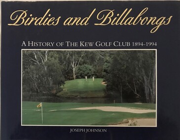
Book, Kew Golf Club, Birdies and billabongs: a history of the Kew Golf Club 1894-1994, 1994
... Heidelberg Golf Club 8 Main Road Lower Plenty 3093 Golf Clubs - Kew Golf Clubs - History Kew Golf Club A history of the first 100 years of Kew Golf Club in Belford Road, East Kew, founded in 1894. ...A history of the first 100 years of Kew Golf Club in Belford Road, East Kew, founded in 1894.206 p., illus. (some col.), maps.non-fictionA history of the first 100 years of Kew Golf Club in Belford Road, East Kew, founded in 1894.golf clubs - kew, golf clubs - history, kew golf club -
 Kew Historical Society Inc
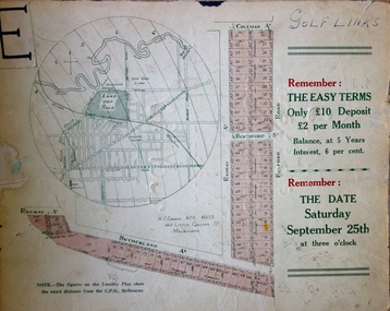
Plan - Subdivision Plan, H C Crouch, Old Golf Links Estate, 1930s
... One part of a massive subdivision of the Old Golf Links Estate in North Kew of 80 allotments bordering Sutherland Avenue, Ramsay Avenue, Belford Road, Beresford Street and Coleman Avenue. ...Lots 73-76 ticked and listed as "6" pounds One part of a massive subdivision of the Old Golf Links Estate in North Kew of 80 allotments bordering Sutherland Avenue, Ramsay Avenue, Belford Road, Beresford Street and Coleman Avenue. ...The land in North Kew between the Outer Circle Railway and the River Yarra was released in sections. This release included 80 lots. Most of this area was released during the Depression years in the early 1930s.Subdivision plans are historically important documents used as evidence of the growth of suburbs in Australia. They frequently provide information about when the land was sold on which a built structure was subsequently constructed as well as evidence relating to surveyors and real estate and financial agents. The numerous subdivision plans in the Kew Historical Society's collection represent working documents, ranging from the initial sketches made in planning a subdivision to printed plans on which auctioneers or agents listed the prices for which individual lots were sold. In a number of cases, the reverse of a subdivision plan in the collection includes a photograph of a house that was also for sale by the agent. These photographs provide significant heritage information relating house design and decoration, fencing and household gardens.One part of a massive subdivision of the Old Golf Links Estate in North Kew of 80 allotments bordering Sutherland Avenue, Ramsay Avenue, Belford Road, Beresford Street and Coleman Avenue. Inset on the plan at the top left, the route of the Outer Circle Railway is clearly marked. The Kew Golf Links is identified in its current location. The land on which Greenacres Golf Club was to be constructed is at this time marked as ‘Recreation Ground’. The ‘new bridge’ over the Yarra at Burke Road is also marked on the inset map. The Plan identifies the surveyor (sic) H.C. Crouch BCE MVIS, 443 Little Collins St., Melbourne. The date of the subdivision auction sale in identified as Saturday September 25th at three o'clock.Annotations: "E" top left. "Golf Links" top right. Lots 73-76 ticked and listed as "6" poundssubdivisions -- kew (vic.), old golf links estate -
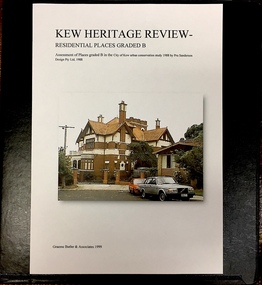 Kew Historical Society Inc
Archive (Sub-series) - Subject File, Kew Heritage Review, Residential Places Graded B, Volume 1, 1999, 1999
... The Butler papers provide an important, and increasingly significant body of heritage research relating to Kew. graeme butler, heritage reviews - kew 20 yarra street 8 yarra street 33 wills street 25 wellington street 11 wellington street 118 walpole street 84 walpole street 83 walpole street 63 walpole street 52 walpole street 51 walpole street 14 vista avenue 12 tara avenue 89 studley park road 75 studley park road 44 studley park road 25 studley park road 13 studley avenue 21 stoke avenue 71 stevenson street 34 stevenson street 12 stevenson street 36 stawell street 11 second avenue 3 second avenue 2 second avenue 34 rowland street 21 redmond street 11 redmond street 16 queen street 27 princess street 82 molesworth street 28 miller grove 26 miller grove 24 miller grove 24 milfay avenue 8 milfay avenue 4 merrion grove 25 mary street 24 lister avenue 2 john street 9 hume street 7 hume street 24 howard street 20 howard street 19 howard street 10 howard street 2 howard street 26 holroyd street 12 holroyd street 73 high street 69 high street 35 high street 6 high street 53 harp road 6 gellibrand street 48 foley street 9 eglinton street 25-27 edgecombe street 21-23 edgecombe street 5-7 edgecombe street 23 dunlop avenue 167 derby street 8 denmark street 1 denmark street 2 daracomb avenue 2 danielle place 340 cotham road 294 cotham road 241 cotham road 221-229 cotham road 208 cotham road 193 cotham road 180 cotham road 171 cotham road 167 cotham road 161 cotham road 135-137 cotham road 46 clyde street 4 cameron court 1291 burke road 1223 burke road 1205 burke road 5 bowen street 35-37 belford road 389 barkers road 387 barkers road 311 barkers road 231 barkers road 83-85 barkers road 15 adeney avenue 6 a'beckett street Black 4-Ring binder that includes research about, and an assessment of buildings previously graded B in the City of Kew Urban Conservation Study 1988 by Pru Sanderson Design Pty Ltd. ...Graeme Butler & AssociatesProject FilesProvenance OrderBlack 4-Ring binder that includes research about, and an assessment of buildings previously graded B in the City of Kew Urban Conservation Study 1988 by Pru Sanderson Design Pty Ltd. The files were created by the heritage architect Graeme Butler and the paper files include maps, correspondence, title searches, readings, reviews of prior classifications, newspaper and journal articles, directories etc for each property assessed.graeme butler, heritage reviews - kew, 20 yarra street, 8 yarra street, 33 wills street, 25 wellington street, 11 wellington street, 118 walpole street, 84 walpole street, 83 walpole street, 63 walpole street, 52 walpole street, 51 walpole street, 14 vista avenue, 12 tara avenue, 89 studley park road, 75 studley park road, 44 studley park road, 25 studley park road, 13 studley avenue, 21 stoke avenue, 71 stevenson street, 34 stevenson street, 12 stevenson street, 36 stawell street, 11 second avenue, 3 second avenue, 2 second avenue, 34 rowland street, 21 redmond street, 11 redmond street, 16 queen street, 27 princess street, 82 molesworth street, 28 miller grove, 26 miller grove, 24 miller grove, 24 milfay avenue, 8 milfay avenue, 4 merrion grove, 25 mary street, 24 lister avenue, 2 john street, 9 hume street, 7 hume street, 24 howard street, 20 howard street, 19 howard street, 10 howard street, 2 howard street, 26 holroyd street, 12 holroyd street, 73 high street, 69 high street, 35 high street, 6 high street, 53 harp road, 6 gellibrand street, 48 foley street, 9 eglinton street, 25-27 edgecombe street, 21-23 edgecombe street, 5-7 edgecombe street, 23 dunlop avenue, 167 derby street, 8 denmark street, 1 denmark street, 2 daracomb avenue, 2 danielle place, 340 cotham road, 294 cotham road, 241 cotham road, 221-229 cotham road, 208 cotham road, 193 cotham road, 180 cotham road, 171 cotham road, 167 cotham road, 161 cotham road, 135-137 cotham road, 46 clyde street, 4 cameron court, 1291 burke road, 1223 burke road, 1205 burke road, 5 bowen street, 35-37 belford road, 389 barkers road, 387 barkers road, 311 barkers road, 231 barkers road, 83-85 barkers road, 15 adeney avenue, 6 a'beckett streetgraeme butler, heritage reviews - kew, 20 yarra street, 8 yarra street, 33 wills street, 25 wellington street, 11 wellington street, 118 walpole street, 84 walpole street, 83 walpole street, 63 walpole street, 52 walpole street, 51 walpole street, 14 vista avenue, 12 tara avenue, 89 studley park road, 75 studley park road, 44 studley park road, 25 studley park road, 13 studley avenue, 21 stoke avenue, 71 stevenson street, 34 stevenson street, 12 stevenson street, 36 stawell street, 11 second avenue, 3 second avenue, 2 second avenue, 34 rowland street, 21 redmond street, 11 redmond street, 16 queen street, 27 princess street, 82 molesworth street, 28 miller grove, 26 miller grove, 24 miller grove, 24 milfay avenue, 8 milfay avenue, 4 merrion grove, 25 mary street, 24 lister avenue, 2 john street, 9 hume street, 7 hume street, 24 howard street, 20 howard street, 19 howard street, 10 howard street, 2 howard street, 26 holroyd street, 12 holroyd street, 73 high street, 69 high street, 35 high street, 6 high street, 53 harp road, 6 gellibrand street, 48 foley street, 9 eglinton street, 25-27 edgecombe street, 21-23 edgecombe street, 5-7 edgecombe street, 23 dunlop avenue, 167 derby street, 8 denmark street, 1 denmark street, 2 daracomb avenue, 2 danielle place, 340 cotham road, 294 cotham road, 241 cotham road, 221-229 cotham road, 208 cotham road, 193 cotham road, 180 cotham road, 171 cotham road, 167 cotham road, 161 cotham road, 135-137 cotham road, 46 clyde street, 4 cameron court, 1291 burke road, 1223 burke road, 1205 burke road, 5 bowen street, 35-37 belford road, 389 barkers road, 387 barkers road, 311 barkers road, 231 barkers road, 83-85 barkers road, 15 adeney avenue, 6 a'beckett street -
 Kew Historical Society Inc
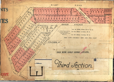
Plan - Subdivision Plan, Old Kew Golf Links Estate - Third Section, 1920-1929
... When the old Kew Golf Links was subdivided in the mid 1920s, the developers were able to break the sale into sections. The third section included eighty lots. The lots faced Kilby Road, Kodak Avenue, Belford...Barnes. subdivision plans - kew old kew golf links estate - third section When the old Kew Golf Links was subdivided in the mid 1920s, the developers were able to break the sale into sections. The third section included eighty lots. The lots faced Kilby Road, Kodak Avenue, Belford ...Pru Sanderson, in her groundbreaking ‘City of Kew Urban Conservation Study : Volume 2 - Development History’ (1988), summarised the periods of urban development and subdivisions of land in Kew. The periods that she identified included 1845-1880, 1880-1893, 1893-1921, 1921-1933, 1933-1943, and Post-War Development. These periods were selected as they represented periods of rapid growth or decline in urban development. An obvious starting point for Sanderson’s groupings involved population growth and the associated economic cycles. These cycles also highlighted urban expansion onto land that was predominantly rural, although in other cases it represented the decline and breakup of large estates. A number of the plans in the Kew Historical Society’s collection can also be found in other collections, such as those of the State Library of Victoria and the Boroondara Library Service. A number are however unique to the collection.The Kew Historical Society collection includes almost 100 subdivision plans pertaining to suburbs of the City of Melbourne. Most of these are of Kew, Kew East or Studley Park, although a smaller number are plans of Camberwell, Deepdene, Balwyn and Hawthorn. It is believed that the majority of the plans were gifted to the Society by persons connected with the real estate firm - J. R. Mathers and McMillan, 136 Cotham Road, Kew. The Plans in the collection are rarely in pristine form, being working plans on which the agent would write notes and record lots sold and the prices of these. The subdivision plans are historically significant examples of the growth of urban Melbourne from the beginning of the 20th Century up until the 1980s. A number of the plans are double-sided and often include a photograph on the reverse. A number of the latter are by noted photographers such as J.E. Barnes.When the old Kew Golf Links was subdivided in the mid 1920s, the developers were able to break the sale into sections. The third section included eighty lots. The lots faced Kilby Road, Kodak Avenue, Belford Road, Baker Avenue, Mathers Avenue, and White Avenue. [Kodak Avenue was renamed Page Avenue at a later date].The ‘Kew Conservation Study (1988) notes that ‘On the subdivision plan, Kodak’s involvement is commemorated by the naming of the streets after Company directors, and their decision to not proceed with the construction of the factory is explained as a response to the increase in the value of the land. This explanation may have been Estate Agent’s hyperbole, as the Kodak Company records suggest that the land, with its wide creek gully, was unsuitable and too small for its purposes.subdivision plans - kew, old kew golf links estate - third section -
 Kew Historical Society Inc
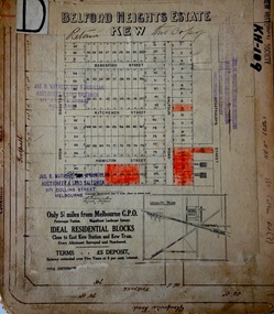
Plan - Subdivision Plan, Belford Heights Estate, Kew, ca. 1925
... The Belford Heights Estate was a subdivision in Kew East, even though the title of the plan indicates that it was located in Kew. The subdivision had been approved by 1915, and included 105 lots facing Strathalbyn, Kitchener, Hamilton and Beresford Streets, as well as Balfour and Belford Roads. ... heights estate subdivision plans - kew The Belford Heights Estate was a subdivision in Kew East, even though the title of the plan indicates that it was located in Kew. The subdivision had been approved by 1915, and included 105 lots facing Strathalbyn, Kitchener, Hamilton and Beresford Streets, as well as Balfour and Belford Roads. ...Pru Sanderson, in her groundbreaking ‘City of Kew Urban Conservation Study : Volume 2 - Development History’ (1988), summarised the periods of urban development and subdivisions of land in Kew. The periods that she identified included 1845-1880, 1880-1893, 1893-1921, 1921-1933, 1933-1943, and Post-War Development. These periods were selected as they represented periods of rapid growth or decline in urban development. An obvious starting point for Sanderson’s groupings involved population growth and the associated economic cycles. These cycles also highlighted urban expansion onto land that was predominantly rural, although in other cases it represented the decline and breakup of large estates. A number of the plans in the Kew Historical Society’s collection can also be found in other collections, such as those of the State Library of Victoria and the Boroondara Library Service. A number are however unique to the collection.The Kew Historical Society collection includes almost 100 subdivision plans pertaining to suburbs of the City of Melbourne. Most of these are of Kew, Kew East or Studley Park, although a smaller number are plans of Camberwell, Deepdene, Balwyn and Hawthorn. It is believed that the majority of the plans were gifted to the Society by persons connected with the real estate firm - J. R. Mathers and McMillan, 136 Cotham Road, Kew. The Plans in the collection are rarely in pristine form, being working plans on which the agent would write notes and record lots sold and the prices of these. The subdivision plans are historically significant examples of the growth of urban Melbourne from the beginning of the 20th Century up until the 1980s. A number of the plans are double-sided and often include a photograph on the reverse. A number of the latter are by noted photographers such as J.E. Barnes.The Belford Heights Estate was a subdivision in Kew East, even though the title of the plan indicates that it was located in Kew. The subdivision had been approved by 1915, and included 105 lots facing Strathalbyn, Kitchener, Hamilton and Beresford Streets, as well as Balfour and Belford Roads. Those lots hand coloured with red probably represent blocks that had been sold. The additional information provided on the plan is also of interest. The plan includes the original location of East Kew State (Primary) School in Strathalbyn Street, which opened in 1892. The inset Locality Plan also includes the route of the Outer Circle Railway and the location of the Wilsmere and East Kew Stations. The location of the landmark Harp of Erin Hotel is also marked on the Locality Plan.belford heights estate, subdivision plans - kew -
 Kew Historical Society Inc
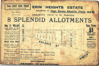
Plan - Subdivision Plan, Erin Heights Estate, East kew, 1917
... Kew included just seven lots in in Valerie Street. These were all that remained of this wartime subdivision, the other 11 allotments on Balfour and Belford Roads having already been sold. ...Kew included just seven lots in in Valerie Street. These were all that remained of this wartime subdivision, the other 11 allotments on Balfour and Belford Roads having already been sold. ...Pru Sanderson, in her groundbreaking ‘City of Kew Urban Conservation Study : Volume 2 - Development History’ (1988), summarised the periods of urban development and subdivisions of land in Kew. The periods that she identified included 1845-1880, 1880-1893, 1893-1921, 1921-1933, 1933-1943, and Post-War Development. These periods were selected as they represented periods of rapid growth or decline in urban development. An obvious starting point for Sanderson’s groupings involved population growth and the associated economic cycles. These cycles also highlighted urban expansion onto land that was predominantly rural, although in other cases it represented the decline and breakup of large estates. A number of the plans in the Kew Historical Society’s collection can also be found in other collections, such as those of the State Library of Victoria and the Boroondara Library Service. A number are however unique to the collection.The Kew Historical Society collection includes almost 100 subdivision plans pertaining to suburbs of the City of Melbourne. Most of these are of Kew, Kew East or Studley Park, although a smaller number are plans of Camberwell, Deepdene, Balwyn and Hawthorn. It is believed that the majority of the plans were gifted to the Society by persons connected with the real estate firm - J. R. Mathers and McMillan, 136 Cotham Road, Kew. The Plans in the collection are rarely in pristine form, being working plans on which the agent would write notes and record lots sold and the prices of these. The subdivision plans are historically significant examples of the growth of urban Melbourne from the beginning of the 20th Century up until the 1980s. A number of the plans are double-sided and often include a photograph on the reverse. A number of the latter are by noted photographers such as J.E. Barnes.The Erin Heights Estate in Kew included just seven lots in in Valerie Street. These were all that remained of this wartime subdivision, the other 11 allotments on Balfour and Belford Roads having already been sold. Balfour Road was to be only a temporary name as the street is currently called Windella Avenue. Now, the parkland opposite the subdivision is the reserve created from the route of the Outer Circle Railway. This Railway reached Kew East in 1925, but had been planned as far back as 1873. The development focuses on the benefits of living in Kew: being at the highest of Kew’s ‘suburbs’; being a good residential area; its rapid growth; and the proximity of the Kew East tram in High Street. In 1917, the electric tramline only extended to a terminus at the Harp of Erin hotel. The terminus is clearly represented on the plan.subdivision plans - east kew, erin heights estate -
 Kew Historical Society Inc
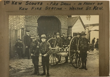
Photograph, 1st Kew Scouts Fire Drill, 1911, 1911
... The Kew Fire Brigade had hand-drawn fire appliances up until 1919 when a motorised vehicle was purchased. The fire station was replaced by the Belford Road station in 1941 and subsequently demolished. ...The Kew Fire Brigade had hand-drawn fire appliances up until 1919 when a motorised vehicle was purchased. The fire station was replaced by the Belford Road station in 1941 and subsequently demolished. 1st Kew Scouts Fire Drill, 1911 Photograph Photograph ...A Volunteer Fire Brigade was established in Kew in 1879 and a fire station established in Walton Street, Kew. The Brigade was formally disbanded by the Fire Brigade Act of 1890 and the volunteers replaced by a unit of the Metropolitan Fire Brigade in 1891. The building shown in this rare photograph was constructed in 1893. In the background can be seen a house on the corner of Walton and Peel Streets, one of two, built in 1893 for firemen of the Brigade. An article in The Weekly Times (1 April 1911) records that: "Kew Troop - A,S.M. Williams reports:- The troop under S.M. Kellett. marched to the Kew Fire Brigade station, to receive instruction in fire drill from Mr Gross, the officer in charge, but as he was unexpectedly called away, the S.M. S and A.S.M had to instruct the Troop. Every boy was taught how to sink the hydrant, and how to couple and uncouple the hose. The hose reel was then brought into action, and the boys were divided into sets of six, each division taking its turn in pulling the reel up a hill to the water plug, where the hydrant was quickly sunk by one Scout, two more uncoupling the hose and coupling it on to the hydrant. We have gained four recruits during the last week, and are expecting two more next week."This is a fine, original photograph, probably taken by a commercial photographer, showing the 1st Kew Scouts in front of the old Kew Fire Brigade building in Walton Street in 1911. The building, constructed in 1893 was later demolished in 1941. This is a rare historic photograph of the Station. Unfortunately the name of the photographer is unrecorded.1st Kew Scouts undertaking a fire drill in front of the old Kew Fire Station in Walton Street, Kew. The reverse details the names and addresses of the Scouts featured in the photograph. An integral part of the Scout program is service to others and working with the fire brigade would have been just one of many such training activities enthusiastically undertaken by the Scouts. The Kew Fire Brigade had hand-drawn fire appliances up until 1919 when a motorised vehicle was purchased. The fire station was replaced by the Belford Road station in 1941 and subsequently demolished. Front: "First Kew Scouts - Fire Drill - In front of Kew Fire Station - Walton St. Kew" Reverse: "Walton St Kew / Kew Fire Station / Mr Gross o/c Fire Station / Bert Gundy Clark, part-time fireman / Allan Sewell Gellibrand St. / Clappy Williams Hawthorn ? / Allan Barrett Cobden St / Allan Woollard High St"kew fire brigade - walton street, scout groups --- kew (vic), 1st kew boy scouts -
 Kew Historical Society Inc
Archive (Sub-series) - Subject File, Fire Brigades, 1958
... A small archive file containing a photocopy (presented by Trinity Grammar School to the Society) of the Rules of the Kew Volunteer Fire Brigade (established 1879), a photocopy of a photo of the Kew MFB officers on a Hupmobile at the entrance to the station, and sundry newspaper articles relating to the Brigade at its later location in Belford Road....Typically files will contain primary and secondary sources. kew (vic) - history walton street - kew (vic) fire brigades - kew (vic) A small archive file containing a photocopy (presented by Trinity Grammar School to the Society) of the Rules of the Kew Volunteer Fire Brigade (established 1879), a photocopy of a photo of the Kew MFB officers on a Hupmobile at the entrance to the station, and sundry newspaper articles relating to the Brigade at its later location in Belford Road. ...Various partiesReference, Research, InformationSecondary Values (KHS Imposed Order)A subject archive file containing a photocopy (presented by Trinity Grammar School to the Society) of the Rules of the Kew Volunteer Fire Brigade (established 1879), a photocopy of a photo of the Kew MFB officers on a Hupmobile at the entrance to the station, and sundry newspaper articles relating to the Brigade at its later location in Belford Road.kew (vic) - history, walton street - kew (vic), fire brigades - kew (vic)kew (vic) - history, walton street - kew (vic), fire brigades - kew (vic) -
 Kew Historical Society Inc
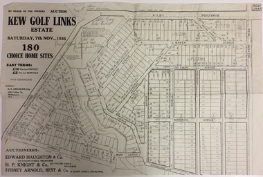
Plan - Subdivision Plan, Kew Golf Links Estate, 1936, 1936
... Kew Golf Links Estate, to be auctioned on 7 November 1936. Streets named include: Carnegie Avenue, Willsmere Road, Kilby Boulevarde, Kodak Avenue, Coleman Avenue, Beresford Avenue, McConchie Avenue, Cole Avenue, White Avenue, Baker Avenue, Spruzen Avenue, Tanner Avenue, Ratten Avenue, Mathers Avenue, Railway Avenue, Sutherland Avenue, and Belford Road. ...Kew Golf Links Estate, to be auctioned on 7 November 1936. Streets named include: Carnegie Avenue, Willsmere Road, Kilby Boulevarde, Kodak Avenue, Coleman Avenue, Beresford Avenue, McConchie Avenue, Cole Avenue, White Avenue, Baker Avenue, Spruzen Avenue, Tanner Avenue, Ratten Avenue, Mathers Avenue, Railway Avenue, Sutherland Avenue, and Belford Road. ...The Kew Golf Links Estate was a major subdivision in North Kew. It derived its title due to the land being previously occupied by the Kew Golf Club, which transferred its course to a number of locations before occupying its current site. The Plan advertises 180 choice home sites. The street names are somewhat different today as those on the map are named after the proposed Kodak Factory to be built on the site. The subdivision of the Kew Golf Links Estate was a major subdivision of farmland in Kew. The site was at one stage designated for industrial development and the building of a new Kodak factory. The decision by Council to oppose the redevelopment makes the beginning of the period when all industrial development was banned in Kew.Monochrome printed, folded subdivision plan for the Kew Golf Links Estate, to be auctioned on 7 November 1936. Streets named include: Carnegie Avenue, Willsmere Road, Kilby Boulevarde, Kodak Avenue, Coleman Avenue, Beresford Avenue, McConchie Avenue, Cole Avenue, White Avenue, Baker Avenue, Spruzen Avenue, Tanner Avenue, Ratten Avenue, Mathers Avenue, Railway Avenue, Sutherland Avenue, and Belford Road. The position of the Yarra River and a large Drainage Reserve are marked on the plan. Lots for sale are numbered. Existing buildings are designated with a square.subdivision plans - kew (vic), kodak factory - kew (vic) -
 Kew Historical Society Inc
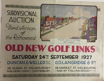
Booklet, Duncan & Weller Pty Ltd, Old Kew Golf Links Estate, 1927, 1927
... Kew in 1927 including 75 charming home allotments and 7 valuable building sites. The brochure includes the subdivision plan. The front cover includes a colour illustration of the almost completed houses in Woolcock Avenue. Streets named include: Kilby Road, Kodak Avenue, Baker Avenue, Mathers Avenue, Coleman Avenue, White Avenue and Belford...Kew in 1927 including 75 charming home allotments and 7 valuable building sites. The brochure includes the subdivision plan. The front cover includes a colour illustration of the almost completed houses in Woolcock Avenue. Streets named include: Kilby Road, Kodak Avenue, Baker Avenue, Mathers Avenue, Coleman Avenue, White Avenue and Belford ...The booklet advertises the third sale within the Old Golf Links Estate which was a major subdivision of farmland in North Kew in the 1920sThe subdivision of the Kew Golf Links Estate was a major subdivision of farmland in Kew. The site was at one stage designated for industrial development and the building of a new Kodak factory. The decision by Council to oppose the redevelopment makes the beginning of the period when all industrial development was banned in Kew.6 page illustrated brochure advertising the third section of a major subdivision in Kew in 1927 including 75 charming home allotments and 7 valuable building sites. The brochure includes the subdivision plan. The front cover includes a colour illustration of the almost completed houses in Woolcock Avenue. Streets named include: Kilby Road, Kodak Avenue, Baker Avenue, Mathers Avenue, Coleman Avenue, White Avenue and Belford Road. Lots for sale are numbered. Existing buildings are designated with a square.subdivisions - kew (vic), kew golf links estate -
 Kew Historical Society Inc
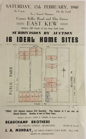
Plan - Subdivision Plan, Subdivision by Auction: 16 Ideal Home Sites, East Kew, 1940, 1940
... Single page subdivision plan advertising the sale by Auction of 16 Ideal Home Sites, in East Kew, on 17 February 1940. Streets named in the plan include: Kilby Road, Belford Road, Elm Grove, Willow Grove. ...Single page subdivision plan advertising the sale by Auction of 16 Ideal Home Sites, in East Kew, on 17 February 1940. Streets named in the plan include: Kilby Road, Belford Road, Elm Grove, Willow Grove. ...An advertisement for the sale of a subdivision by Auction: of 16 Ideal Home Sites, East Kew, 1940. This significant sale of land between the Kew Golf Course and Willsmere Park led to the streets having a high degree of architectural uniformity.The subdivision in the second year of the war indicates that land sales for homes and speculation continued from the 1930s into the period of the Second World War. There is no indication on the plan that a war is occurring.Single page subdivision plan advertising the sale by Auction of 16 Ideal Home Sites, in East Kew, on 17 February 1940. Streets named in the plan include: Kilby Road, Belford Road, Elm Grove, Willow Grove. Willsmere Park is indicated but not named. The auction was conducted by Beauchamp Brothers. A number of lots are coloured pink on the plan indicating those lots for sale and/or those already sold.subdivision plans - kew east (vic)