Showing 145 items matching "black cameron road"
-
 Eltham District Historical Society Inc
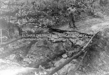
Album - Photograph, J.A. McDonald, Black Cameron Road, Smiths Gully, Aug. 1962
... Black Cameron Road, Smiths Gully......Black Cameron Road...Black Cameron Road Bridge over Salters Rush Creek following bush fires 15-16 Jan. 1962...The negatives have been catalogued separately and relevant relationships to pages highlighted in catalogue record. Black Cameron Road, Smiths Gully Album Photograph J.A. ...Black Cameron Road Bridge over Salters Rush Creek following bush fires 15-16 Jan. 1962Record of various Shire of Eltham infrastructure works undertaken during the period of 1952-1962 involving bridge and road reconstruction projects, sometimes with Eltham Shire Council Project Reference numbers quoted. It was during this period that a number of significant improvements were made to roads and new bridges constructed within the shire that remain in place as of present day (2022). In many situations, the photos provide a tangible visible record of infrastructure that existed throughout the early days of the Shire. The album was put together by or under the direction of the Shire Engineer, J.A. McDonald.H941 stamped on reverse (film processing #)infrastructure, shire of eltham, bridge construction, road construction, 1962-08, bushfires, victorian bushfires - 1962, black cameron road, smiths gully -
 Eltham District Historical Society Inc
Archive Box, Eltham War Memorial
... Also included: o Submission: Eltham War Memorial Buildings; prepared by Catherine Johnson of Pryor Street, Eltham for the Heritage Council Victoria; 17 July 2020 o Submission: Eltham War Memorial Buildings; prepared by Andrew Barras of Silver Street, Eltham for the Heritage Council Victoria; 10 July 2020 o Submission: Eltham War Memorial Buildings; prepared by Graham Fildes of Elouera Close, Eltham for the Heritage Council Victoria; 11 July 2020 o Submission: Eltham War Memorial Buildings; prepared by Eltham District Historical Society for the Heritage Council Victoria; 17 July 2020 o Submission: Eltham War Memorial Buildings; prepared by Julie Willis of Faculty of Architecture, Building and Planning, University of Melbourne for the Heritage Council Victoria; 17 July 2020 o Submission: Eltham War Memorial Buildings; prepared by Ms Zheng Wu of Wynton Ct, Eltham for the Heritage Council Victoria; 16 July 2020 o Submission: Eltham War Memorial Buildings; prepared by Jenny Daw of Black Cameron Road, Smith Gully for the Heritage Council Victoria; 19 July 2020 o Submission: Eltham War Memorial Buildings; prepared by Eltham Pre-School for the Heritage Council Victoria; 19 July 2020 o Submission: Eltham War Memorial Buildings; prepared by Jo-Anne Barker of Treloar Ave, Eltham for the Heritage Council Victoria; 18 July 2020 o Submission: Eltham War Memorial Buildings; prepared by Prof. ...Also included: o Submission: Eltham War Memorial Buildings; prepared by Catherine Johnson of Pryor Street, Eltham for the Heritage Council Victoria; 17 July 2020 o Submission: Eltham War Memorial Buildings; prepared by Andrew Barras of Silver Street, Eltham for the Heritage Council Victoria; 10 July 2020 o Submission: Eltham War Memorial Buildings; prepared by Graham Fildes of Elouera Close, Eltham for the Heritage Council Victoria; 11 July 2020 o Submission: Eltham War Memorial Buildings; prepared by Eltham District Historical Society for the Heritage Council Victoria; 17 July 2020 o Submission: Eltham War Memorial Buildings; prepared by Julie Willis of Faculty of Architecture, Building and Planning, University of Melbourne for the Heritage Council Victoria; 17 July 2020 o Submission: Eltham War Memorial Buildings; prepared by Ms Zheng Wu of Wynton Ct, Eltham for the Heritage Council Victoria; 16 July 2020 o Submission: Eltham War Memorial Buildings; prepared by Jenny Daw of Black Cameron Road, Smith Gully for the Heritage Council Victoria; 19 July 2020 o Submission: Eltham War Memorial Buildings; prepared by Eltham Pre-School for the Heritage Council Victoria; 19 July 2020 o Submission: Eltham War Memorial Buildings; prepared by Jo-Anne Barker of Treloar Ave, Eltham for the Heritage Council Victoria; 18 July 2020 o Submission: Eltham War Memorial Buildings; prepared by Prof. ...CONTENTS: BOX 1 04585-1 04585 History • 04585-1-1 An Outline History of the Eltham War Memorial Trust by Stanley S. Addison • 04585-1-2 Stanly Addison's notes for his Outline History of the Eltham War Memorial Trust • 04585-1-3-1 Newspaper article: Eltham War Memorial Trust: Ready Now for Forward Movement; Acknowledgements £722; publication unknown, c.1946 • 04585-1-3-2 Newspaper article: Eltham War Memorial Trust: "Garden of Remembrance"; Baby Health Centre First Building, The News: The Newspaper of the City of Heidelberg and of the Shire of Eltham, 11 April 1947 • 04585-1-3-3 Newspaper: The News: The Newspaper of the City of Heidelberg and of the Shire of Eltham; Friday, December 1, 1950 • 04585-1-3-4 Newspaper article: Eltham War Memorial Trust by Stanley Addison, 1953 • 04585-1-3-5 Newspaper article: War Memorial Trust (publication unknown, n.d.) • 04581-1-4 Folder: A brief history of the Eltham War Memorial and Eltham Library, Harry Gilham, 1997-1999 • 04585-1-5 Newspaper article: Eltham's War Memorial; A Journey in Time, Nillumbik Mail, 5 July c.2001 04585-2 Eltham War Memorial Trust Minutes • 04585-2-1 Eltham War Memorial Trust Minutes, Book No. 2, 20 March 1951 to 4 June 1957 • 04585-2-2 Minute Book: Eltham War Memorial Trust Minutes, 2 July 1957 to 12 November 1973 BOX 2 04585-3 Women's Auxiliary, Eltham War Memorial Trust • 04585-3-1-1 Minute Book: Minute Book No. 1, Women's Auxiliary, Eltham War Memorial Trust, 10 May 1946 to 10 April 1952 • 04585-3-1-2 Minute Book: Minute Book No. 2, Women's Auxiliary, Eltham War Memorial Trust, 12 June 1952 to 14 June 1956 • 04585-3-1-3 Minute Book: Minute Book No. 3, Women's Auxiliary, Eltham War Memorial Trust, 12 July 1957 to 14 May 1959 • 04585-3-1-4 Minute Book: Minute Book No. 4, Women's Auxiliary, Eltham War Memorial Trust, 14 May 1959 to 12 August 1965 • 04585-3-2 Book: A favourite book of country recipes / compiled by the Women's Auxiliary of the Eltham War Memorial Trust 04585-4 04591 Eltham Easter Show and Gymkhana • 04585-4-1 Minute Book: Eltham War Memorial Trust; Easter Gymkhana Committee Minutes, 19 Nov 1954-6 Jun 1958 • 04585-4-2 Folder: Eltham War Memorial Trust; Easter Gymkhana Committee Correspondence, 19 Nov 1954-6 Jun 1958 o 04585-4-2-1 Notice from Honorary Treasurer of Easter Gymkhana Committee regarding completion of 1954 event and expression of thanks and that committee is now going into recess prior to commencement of planning for 1955 o 04585-4-2-2 Notice of Easter Gymkhana Committee Meeting, Monday 24th October, 1955 at the Shire Hall, Eltham o 04585-4-2-3 Letter from B.T. Taylor, Hon. Secretary, Eltham Easter Show Committee regarding the sale of tickets (c.1957) o 04585-4-2-4 Letter from B.T. Taylor, President, Eltham Easter Show Committee to Georges Ltd regarding the supply of The Georges Cup for the Eltham Easter Show, 11 April 1958 o 04585-4-2-5 Letter from Georges Ltd to B.T. Taylor, President, Eltham Easter Show Committee with payment for the miniatures of The Georges Cup, 6 June 1958 o 04585-4-2-6 Letter from Eltham Shire Secretary to B.T. Taylor, President, Eltham Easter Show Committee advising of new process regarding raffle, 5 May 1958 o 04585-4-2-7 Letter from Lilian Heath, Secretary, Judge Book Village Auxiliary to B.T. Taylor, Eltham Easter Show Committee, 24 May 1958 o 04585-4-2-8 Letter from Mrs R.J. Godfrey on behalf of M.A. Godfrey of Dandenong to B.T. Taylor, President, Eltham Easter Show under threat of legal action requesting replacement of cheque for £10 (second prize Open Jumping Contest), which was lost, 24 May 1958 o 04585-4-2-9 Reply by B.T. Taylor, President, Eltham Easter Show Committee to Mrs R.J. Godfrey to her letter of 24 May explaining circumstances and denying responsibility to forward a replacement cheque as it was cashed at the Golf Club Hotel; 6 June 1958 • 04585-4-3 Folder: Easter Gymkhana Committee Minutes and other associated ephemera o 04585-4-3-1 Letter: Letter of donation to Shire of Eltham Historical Society of the Easter Gymkhana Committee Minutes and other associated ephemera, J.M. Peter Bassett-Smith, 31 October 1987 o 04585-4-3-2 Souvenir Program: Free Program; Eltham Easter Gymkhana and Light Horse Show also Dog Competition, Easter Saturday 9th April, 1955 at Eltham (Lower) Park o 04585-4-3-3 Program Schedule; Eltham Easter Gymkhana and Light Horse Show also Dog Competition, Easter Saturday 9th April, 1955 at Eltham (Lower) Park o 04585-4-3-4 Program; Monster Gymkhana in aid of Hurstbridge Hall Re-Building Fund, Hurstbridge Recreation Reserve, Sunday, September 18, 1955 o 04585-4-3-5 Record Crowd Came To Eltham Gymkhana, Sporting World, Diamond Valley Local, Thursday, April 14, 1955, p8 o 04585-4-3-6 Program; Eltham Easter Gymkhana Goat Show Schedule, Easter Saturday 31st March, 1956, Eltham Park o 04585-4-3-7 Official Program; Eltham Easter Horse Show and Goat Show, Easter Saturday April 20th, 1957, Eltham Park o 04585-4-3-8 Program Schedule; Eltham Easter Horse Show and Goat Show, Easter Saturday April 20th, 1957, Eltham Park o 04585-4-3-9 Young Rider to Judge at Show, The Age, Wednesday, April 17, 1957, p8 o 04585-4-3-10 Promotional window label, Eltham Gymkhana, Easter Saturday, 20 April 1957 o 04585-4-3-11 Entry form for the Skyline Drive-In “Soap-Box” Derby, to be held along Main Road between Panorama Avenue and Bolton Street, Easter Saturday, 20 April 1957 o 04585-4-3-12 Official Program; Eltham Easter Horse Show and Goat Show, Easter Saturday, 5th April, 1958, Eltham Park o 04585-4-3-13 Brief history of the Eltham War Memorial Trust and Women's Auxiliary, Peter Bassett-Smith, 1987 o 04585-4-3-14 Summary of the Eltham War Memorial Trust Easter Gymkhana Committee Minutes (1954-1956) 04585-5 Folder: Infant Welfare Centre (1952) 04585-5-1 Newspaper article: Eltham: “Memorial Baby Health Centre Opening”; District News, The News, 14 November 1952. (Single sheet newsprint printed one side with District News for Macleod, Kinglake, Watsonia, Wattle Glen, Diamond Creek, Panton Hill, Eltham North, Lower Plenty, Research, Eltham. On reverse in handwritten purple pencil to the President, somewhat indecipherable, about an item to be hung on the walls of the beautiful building.) • 04585-5-2 Eltham War Memorial Trust, Official Opening - Baby Health Centre, 15th November 1952; Timetable of proceedings (1 page handwritten) • 04585-5-3 Eltham Baby Health Centre; Official Opening - Baby Health Centre: Address by President, 15 November 1952 (9 pages handwritten) • 04585-5-4 Newspaper article: Infant Welfare Centre as War Memorial, 15 November 1952 • 04585-5-5 Souvenir Booklet: Eltham War Memorial Trust, 1954 • 04585-5-6 Eltham War Memorial: Address by Mrs Stanley Addison at the Annual Meeting of the Infant Welfare Centre, Thursday 21st October, 1965 (4 pages typed, carbon copy) 04585-6 Roll of Honour Board (1954), Eltham War Memorial 04585-7 Eltham Pre-School (1956), Eltham War Memorial • 04585-7-1 Newspaper article: Minister to open Eltham Pre-school Tomorrow • 04585-7-2 Program; Eltham War Memorial Trust: Opening of the Second Unit of the War memorial, The Pre-school Centre, on Saturday, December 1st, 1956 at 3 p.m. • 04585-7-3 Folder: Eltham Pre-School (1956) Papers donated by Gordon Pearce, 30 Apr 2021 pertaining to Eltham Pre-school and Eltham War Memorial Trust. Gordon was a former President of the Eltham Pre-school at the time the Eltham War Memorial Trust was disbanded by Eltham Shire Council in December 1973. o Articles of the Eltham War Memorial Trust (9 A3 photocopies of original foolscap pages) o President’s Report: Eltham War Memorial Trust, Committee of Management, Dec. 1973 in which it was advised that the Committee was to be disbanded. o Letter: Gordon J.J. Pearce, President Eltham Pre-school to C.J. Bock, Chief Administrative Officer, Shire of Eltham, 21 Nov 1973 expressing disappointment at the Shire wanting to disband the Committee of Management of the Eltham War Memorial Trust o Minutes: Eltham Pre-school Committee, 26 Nov 1973 o Minutes: Eltham Pre-school Committee, 17 Dec 1973 o President’s Report: Gordon Pearce, Eltham Pre-school, 4 Feb 1974 • 04585-7-4 Newspaper clipping: A humble beginning, Diamond Valley Leader, July 26, 2006, p35 04585-8 Children’s Library (1961) / Eltham War Memorial Hall (1966) • 04585-8-1 Letter: Hon. Secretary Eltham Shire Council inviting Lieut-General The Honourable Sir Edmund Herring to attend the opening of the Children's Library. 23 Aug. 1961 • 04585-8-2 Newspaper article: Third unit of Eltham's memorial opened; Diamond Valley News, 14 Nov 1961 (Ref: SEA_74_001-055) • 04585-8-3-1 Receipt to Eltham Historical Society for hire of Eltham War Memorial Hall, 23 June 1970 • 04585-8-3-2 Receipt to Eltham Historical Society for hire of Eltham War Memorial Hall, 6 July 1970 • 04585-8-4 A brief history of the Eltham Library, Harry Gilham, c.1994 04585-9 Eltham Enlistments for the Second World War 04585-1964 • Document: Photocopy of Certificate of Title, Eltham War Memorial Trust, Lot 2, Plan of Subdivision No. 63242, Parish of Nillumbik; derived from Vol. 7073 Fol. 498, 18 May 1964 04585-1996 (Eltham Town Focus Group) Documents relating to a focus group brought together by the Shire of Nillumbik Chairman of Commissioners in 1996 to provide advice on the best long term use for the buildings and land situated between the former Eltham Shire Offices and Country Fire Authority buildings. These buildings are known as the Eltham War Memorial buildings located at 903-907 Main Road, Eltham. In May 2020, the Heritage Council Victoria did not recommend the site for inclusion in the Victorian Heritage Register. Potential impact upon the Memorial Garden because of a proposed roundabout at Dudley Street and Main Road • Notes concerning impact upon Eltham War Memorial Garden of a proposed roundabout at Dudley Street, Eltham, 20 August 1996 • Draft proposal of a roundabout at Dudley Street and Main Road showing impact upon Eltham War Memorial Garden, c. Sep. 1996 • Letter (copy): Harry Gilham, President, EDHS to Bruce Ruxton, President, Victorian RSL concerning impact upon Eltham War Memorial Garden of a proposed roundabout at Dudley Street, Eltham, 1 September 1996 • Letter: Bruce Ruxton, President, Victorian RSL to Harry Gilham, President, EDHS, 20 Sep 1996 concerning impact upon Eltham War Memorial Garden of a proposed roundabout at Dudley Street, Eltham, including copy of communication with Eltham RSL (T. Beaton, Hon Sec.) of 10 Sep 1996 • Letter: EDHS (H. Gilham, President) to Commissioners, Nillumbik Shire Council, 16 Sep 1996 advising not in support of roundabout at Dudley Street due to impact upon Eltham War Memorial Garden • Photocopy: Editorial comment, Peter Doughterty, ArtStreams Dec 1996/Jan 1997 re Commissioners push for development in activity zone of former office site and Eltham War Memorial (see EDHS_04362) • Letter: Don Cordell, Chairman of Commissioners, Nillumbik Shire Council, 10 Dec. 1996 inviting Harry Gilham to join a Focus Group to advise him, chaired by Alan Field. Includes a list of focus group members and contact details. • Minutes of Meeting, Eltham Town Focus Group, 17 Dec. 1996 04585-1997 (Eltham Town Focus Group) Documents relating to a focus group brought together by the Shire of Nillumbik Chairman of Commissioners in 1996 to provide advice on the best long term use for the buildings and land situated between the former Eltham Shire Offices and Country Fire Authority buildings. These buildings are known as the Eltham War Memorial buildings located at 903-907 Main Road, Eltham. In May 2020, the Heritage Council Victoria did not recommend the site for inclusion in the Victorian Heritage Register. Investigating condition of and future use of the Eltham War Memorial Complex and redevelopment of the site • Letter: Alan Field to Harry Gilham. 8 Jan. 1997 advising date of 18 Jan. for next meeting of Eltham Town Focus Group • Minutes of Meeting, Eltham Town Focus Group, 18 Jan. 1997 with handwritten notes by Harry Gilham • Draft Report: A Community Vision for “The Eltham War Memorial Trust” Property, Main Road, Eltham, prepared at the request of Chief Commissioner, Don Cordell, 31 Jan. 1997, along with handwritten nots by Ross McDonald and accompanying note by Harry Gilham written in 2010 upon handover of EDHS presidency 04585-2000 • Notes used by Harry Gilham at Nillumbik Council Meeting of 21 March 2000 regarding proposed sale/development of the Eltham War Memorial property 04585-2004 Material covers Eltham Major Activity Structure Plan and a proposal by Council to sell the Eltham War Memorial site for commercial use • Eltham Major Activity Structure Plan Comments Sheet; Response by Harry Gilham, 22 June 2004 • Letter from Eric Mack to the Hon. Steve Herbert, Member for Eltham regarding draft Major Activity Centre Structure Plan, 22 June 2004 • Newspaper article: Protect war memorial, Harry Gilham, President, Eltham District Historical Society; Letter, Diamond Valley Leader, June 30, 2004, p16 (Includes copy sent to paper 17 June) • Letter from Eric Mack to Nillumbik Shire Council CEO and Councillors regarding draft Major Activity Centre Structure Plan, 2004 • Copy of fax sent by John Cohen, OAM, JP to Diamond Valley News, re his support for the appeal for protection of the Eltham War Memorial 3 July 2004 • Newspaper article: Sell-off a betrayal of trust, Ken Eckersall; Letters, Diamond Valley Leader, 7 July 2004 • Newspaper article: Don't insult memory of fallen servicemen, John Cohen; Letters, Diamond Valley Leader, 7 July 2004 • Newspaper article: Up in arms against sell-off, Dave Crosswaite, Diamond Valley Leader, July 14, 2004, p5 • Copy of letter from John Cohen to President and Executive of the Eltham RSL regarding the Eltham War Memorial, 16 July 2004 • Reply to Eric Mack from the Hon. Steve Herbert, Member for Eltham regarding his letter of 22 June, 27 July, 2004 • Notice issued by Cr Greg Johnson of 11 August meeting by Council's Policy and Services Committee to consider a proposal to sell the Eltham War memorial and old shire office properties, 6 August 2004 • Minutes for the policy and Services Committee of Nillumbik Shire Council held Wednesday 11 August 2004 • Newspaper article: Shire plan 'sacrilegious' by Dave Crossthwaite, Diamond Valley Leader, Wednesday, August 19, 2004, p1 • Newspaper article: Our say on sale of land; Have you say, Diamond Valley Leader, August 18, 2004, p22 • Newspaper article: School hall is not ratepayers' worry; Have your Say, Diamond Valley Leader, August 18, 2004, p23 • Copy of letter sent by John Cohen, OAM, JP to the CEO, RSL Victoria requesting their opposition to sale of the Eltham War Memorial, 19 August 2004 • Newspaper article: Clash over land sale by Dave Crossthwaite, Diamond Valley Leader, August 25, 2004, p1 • Newspaper article: Mayor beset over arts agenda claim by Dave Crossthwaite, Diamond Valley Leader, August 25, 2004, p5 • Newspaper article: A lot of work has gone into shire structure plan; Letters, Diamond Valley Leader, August 25, 2004, p10 • Newspaper article: Public assets are not for sale; Letters, Diamond Valley Leader, August 25, 2004, p11 • Copy of letter sent by John Cohen, OAM, JP to Brigadier J.R. Deighton, State Secretary, Victorian RSL re his comments in Diamond Valley Leader regarding the Eltham War Memorial, 27 August 2004 • Handwritten notes prepared by Harry Gilham in preparation of presentation to Council pertaining to draft Eltham Major Activity Structure Plan, c. Sep. 2004 • Newspaper article: Don't let a dream stay hijacked; Letters, Diamond Valley Leader, September 1, 2004, p11 • Ordinary Meeting of Council Agenda, 15 September 2004, p55 with notes on vote for motion that any reference to the sale of the War Memorial be removed • Copy of letter sent by John Cohen, OAM, JP to Brigadier J.R. Deighton, State Secretary, Victorian RSL advising the War Memorial had been removed from the wider proposal of the Eltham Activity Centre, 16 September 2004 • Newspaper article: Future of memorial site on hold until poll by Caroline Gonzalez, Diamond Valley Leader, September 20, 2004 • Fax from Catherine Dale, CEO, Nillumbik Shire Council to John Cohen re Renovation and Maintenance of Victorian War Memorials, 6 October 2004 • Letter from Cr Tony Raunic, Mayor to Harry Gilham regarding Eltham Major Activity Centre Structure Plan advising the removal of any reference to sale of the War Memorial and detailed consultation to be held with stakeholders regarding the former Shire of Eltham Office site; 8 October 2004 • Letter from Barry Rosewall, President, Eltham RSL to John Cohen advising the sub-branch strongly opposes the sale of the Eltham War Memorial, 20 October 2004 • Fax from Bill Forrest, Interim CEO, Nillumbik Shire Council to John Cohen re Renovation and Maintenance of Victorian War Memorials, 8 November 2004 • Copy of letter from John Cohen to Bill Forrest, Interim CEO, Nillumbik Shire Council re Maintenance of Eltham War Memorial, November 2004 04585-2007 • News article: The spin starts here; Brian Murray, Nillumbik Ratepayers’ Association, Valley Views, Diamond Valley Leader, 13 June 2007 suggesting Council proposing to bring back Shire Offices to Eltham with potential loss of Eltham War Memorial • News article: War memorial fear-mongering; Harry Gilham, Heidelberg Valley Weekly, 26 June 2007 • News article: Consultation is no spin; John Cohen, Former Shire President, Valley Views, Diamond Valley Leader, 27 June 2007 • News article: Troops enlist for campaign by Fiona Willan, Diamond Valley Leader, 18 July 2007 04585-2010 • Newspaper article: Hall 'scruffy' - war vet, Diamond Valley Leader, 17 February 2010, p2 04585-2011 Cultural Significance Assessment • Cultural Heritage Significance Assessment; Civic Building Complex, 903-907 Main Road, Eltham, September 2011 DRAFT • Feedback to Nillumbik Shire Council by Eltham District Historical Society in response to September 2011 Draft Cultural Heritage Significance Assessment of the Eltham War Memorial Building Complex, 3 November 2011 • War Memorial Building Complex, 903-907 Main Road, Eltham: Cultural Significance Assessment, November 2011 prepared for Nillumbik Shire Council by Samantha Westbrooke Pty Ltd in association with Peter Mills PhD, Architectural Historian 04585-2014 Proposed extension to Cenotaph War Memorial Terrace championed by Montmorency-Eltham RSL and its impact upon the Memorial Garden and Eltham War Memorial buildings complex. • Draft Landscape Concept Plan by Henry Architects for Proposed Extension to Memorial Terrace, 14 July 2014 (Note: Senior Citizen’s Building correctly identified. Every subsequent plan incorrectly shows this building as the former Children’s Library, which was the War Memorial Hall building) • Letter: Eltham Gateway Action Group to Stuart Burdack, Shire of Nillumbik (undated) offering comment on Proposed Extension to Memorial Terrace with handwritten notes • Letter: Jim Connor, President, EDHS to Adrian Cully, Manager Community Participation, Learning and Culture, Nillumbik Shire Council, 18 Aug. 2014, encouraging Council not to support proposed extension to War Memorial Terrace due to significant impact upon the Eltham War Memorial Complex as supported by the Cultural Significance assessment conducted by Council in 2011 • Notices of Motion, NOM.001/14 pertaining to memorials Advisory Committee and Montmorency-Eltham RSL to upgrade the Eltham War Memorial site in time for ANZAC Day 2015, Nillumbik Shire Council Ordinary Meeting, 26 August 2014 • Notices of Motion, NOM.001/14 pertaining to memorials Advisory Committee and Montmorency-Eltham RSL to upgrade the Eltham War Memorial site in time for ANZAC Day 2015, Nillumbik Shire Council Ordinary Meeting, 26 August 2014 • Media Release: Support for cenotaph expansion, Nillumbik Shire Council, Sep 2014 • Eltham War Memorial Park (Stage 2), Nillumbik Shire Council, c.2014 • Email (copy): Summary of advice from Samantha Westbrooke (2 Sep. 2014) regarding proposed impact of landscaping around the cenotaph as identified in the significance assessment conducted Nov. 2011 by herself and Dr Peter Mills. • Policy and Services reports, PSD.034/14 Eltham War Memorial Building Precinct - Proposed Extension to Memorial Terrace, Nillumbik Shire Council Ordinary Meeting, 9 September 2014 • EDHS presentation to NSC Policy and Services meeting 9 September 2014 regarding the Montmorency-Eltham RSL proposal to expand/upgrade the Eltham War Memorial with handwritten notes from Harry Gilham for his submission at Council meeting • Newspaper article: Plan to expand memorial; growth in ANZAC Day services inspires RSL proposal by Megan Bailey, Diamond Valley Leader, Wednesday, September 10, 2014 • Agenda: User Groups and Stakeholders Meeting, Proposed Extension to Memorial Terrace, 11 September 2014 • Email: Jim Connor, EDHS, regarding option to seek a heritage protection overlay for the Eltham War Memorial Building complex similar to that for the cenotaph, 15 Sep. 2014 • Newspaper article: Council defers RSL war memorial upgrade to seek consultation, Diamond Valley Leader, September 17, 2014 • Letter: Harry Gilham to Local Press, 20 Sep. 2014 regarding the Eltham War Memorial and moves by the RSL to take expand the War Memorial Terrace further into the orginal Memorial Garden • Letter: Alan Field, President, The Eltham Veterans War Memorial Preservation Society Inc. to CEO and Councillors, Nillumbik Shire Council protesting at perceived injustices and ‘veteran bashing’ regarding their previous efforts to relocate ‘their Obelisk and Cenotaph’ to the Eltham War Memorial complex and their frustration in their attempts to further expand upon the Memorial Terrace. Areas of letter are highlighted with handwritten markups and notes. Also notes on loose card and paper with definitions of Memorial, Obelisk, Cenotaph, commentary on establishment of Eltham War Memorial, The Eltham War Memorial Trust and RSL involvement and current actions by RSL in respect to claims in the letter (written by Harry Gilham ?). • Newspaper article: Residents say no to memorial upgrade; Mayor says feedback will be considered at next meeting by Megan Bailey, Diamond Valley Leader, Wednesday, October 1, 2014 • Policy and Services reports, PS.038/14 Eltham War Memorial Building Precinct - proposed extension to the Eltham Cenotaph Terrace, Nillumbik Shire Council Policy and Services Committee Meeting, 14 October 2014 • Newspaper article: Centenary dawn service moves to Petrie Park; Diamond Valley Leader, October 22, 2014, p5 • Newspaper article: Upset over upgrade; war memorial plans get culled; Diamond Valley Leader, October 29, 2014, p3 • Newspaper article: Memorial to be extended; expected to be finished before ANZAC Day ceremony by Megan Bailey, Diamond Valley Leader, December 17, 2014 04585-2018 Proposal by Nillumbik Shire Council to sell off former Eltham Shire Office site and Eltham War Memorial site for commercial use and community reaction. • Newspaper article: Site of contention; Conversations, Diamond Valley Leader, September 5, 2018, p10 • Motion to Councillors: Carlotta Quinlan, Eltham Community Action Group, [October 2018] following a Community Town Hall Meeting held October 13, 2018 regarding proposed development and sale of part of 895 and 903-907 Main Road, Eltham • Things you should know about the Eltham War Memorial, author unknown, c. Oct. 2018 • Email: Greg Johnson to Sue Dyet 16 October 2018 regarding Assessment Criteria discussed at 25 September 2018 Council meeting concerning proposed development and sale of part of 895 and 903-907 Main Road, Eltham • Newspaper article: War memorial assurance; RSL involved but no-confidence motion passed on council by Brittany Shanahan, Diamond Valley Leader, October 17, 2018 • An essay addressed to the Councillors of Nillumbik Shire, October 2018: About the Eltham War Memorial and the adjacent community-owned sites in Eltham that the Council threatens to sell, Andrew Lemon Nov. 2018 • Report: Request for proposals - For the development and sale of part of 895 and 903-907 Main Road, Eltham; Prepared for Nillumbik Shire Council by Maddocks; 2 November 2018 (229 pages) • Notice: Duncan Duke, President, Montmorency Eltham RSL, to Members, 5 December 2018 – statement regarding “proposed redevelopment of the Eltham War Memorial Buildings and potential impact of the proposed redevelopment on our (sic) Cenotaph and Memorial Site.” 04585-2020 Community motions to seek Heritage Council Victoria registration of the Eltham War Memorial precinct • Eltham War Memorial Buildings: Recommendation of the Executive Director and assessment of cultural heritage significance under Part 3, Division 3 of the Heritage Act 2017; 18 May 2020 • Newspaper advertisement: Heritage Council Victoria, advising the Eltham War Memorial Buildings have been recommended NOT for inclusion in the Victorian Heritage Register; The Age, May 22, 2020, p34 • Correspondence: Eltham War Memorial Buildings; prepared by Nillumbik Shire Council for the Heritage Council Victoria; 29 May 2020 • Correspondence: Eltham War Memorial Buildings; prepared by Nillumbik Shire Council for the Heritage Council Victoria; 5 June 2020 • Submission: Eltham War Memorial Buildings; prepared by Eltham Community Action Group for the Heritage Council Victoria; 17 July 2020. Also included: o Submission: Eltham War Memorial Buildings; prepared by Catherine Johnson of Pryor Street, Eltham for the Heritage Council Victoria; 17 July 2020 o Submission: Eltham War Memorial Buildings; prepared by Andrew Barras of Silver Street, Eltham for the Heritage Council Victoria; 10 July 2020 o Submission: Eltham War Memorial Buildings; prepared by Graham Fildes of Elouera Close, Eltham for the Heritage Council Victoria; 11 July 2020 o Submission: Eltham War Memorial Buildings; prepared by Eltham District Historical Society for the Heritage Council Victoria; 17 July 2020 o Submission: Eltham War Memorial Buildings; prepared by Julie Willis of Faculty of Architecture, Building and Planning, University of Melbourne for the Heritage Council Victoria; 17 July 2020 o Submission: Eltham War Memorial Buildings; prepared by Ms Zheng Wu of Wynton Ct, Eltham for the Heritage Council Victoria; 16 July 2020 o Submission: Eltham War Memorial Buildings; prepared by Jenny Daw of Black Cameron Road, Smith Gully for the Heritage Council Victoria; 19 July 2020 o Submission: Eltham War Memorial Buildings; prepared by Eltham Pre-School for the Heritage Council Victoria; 19 July 2020 o Submission: Eltham War Memorial Buildings; prepared by Jo-Anne Barker of Treloar Ave, Eltham for the Heritage Council Victoria; 18 July 2020 o Submission: Eltham War Memorial Buildings; prepared by Prof. Hannah Lewi of Faculty of Architecture, Building and Planning, University of Melbourne for the Heritage Council Victoria; 18 July 2020 o Submission: Eltham War Memorial Buildings; prepared by Janet Boddy of Kerrie Cres, Eltham for the Heritage Council Victoria; 19 July 2020 o Submission: Eltham War Memorial Buildings; prepared by Rosemary Aitken of Kent Hughes Rd., Eltham for the Heritage Council Victoria; 18 July 2020 o Submission: Eltham War Memorial Buildings; prepared by Sue Dyet of Leonard Cres., Eltham for the Heritage Council Victoria; 19 July 2020 o Submission: Eltham War Memorial Buildings; prepared by Lynnsay Prunotto of Lavender Park Rd., Eltham for the Heritage Council Victoria; 19 July 2020 o Submission: Eltham War Memorial Buildings; prepared by Felicity Bing of Eltham Pre-School for the Heritage Council Victoria • Draft Report: Eltham War Memorial Building Complex, 903-907 Main Road, Eltham, prepared by CONTEXT, (Survey Date: Dec. 2020) Also contained in Box 2 is EDHS_04586 – Eltham Obelisk EDHS_04586 - Eltham Obelisk The Eltham Obelisk was originally located at the corner of Bridge and Main Roads in 1919. It commemorated the memory of the Eltham Soldiers who fell in the First World War and complemented the Eltham Avenue of Honour established in 1917 to those that served. In 1943 (WW2) the local community commenced plans to establish the Eltham War Memorial, a living memorial to benefit the children as opposed to a one in stone as per the obelisk. The Eltham War Memorial Trust was established in 1945. In 1947 the Trust intended for the Obelisk to be relocated from Bridge Street and Main Road to the Garden of Remembrance which was planned as part of the Baby Health Centre which was to be the first of three buildings of the Eltham War Memorial to be built in 1951. In 1951 the Eltham RSL was invited to be represented on the Eltham War Memorial Trust. During the period of Jun through October 1956 the original wooden bridge over the Diamond Creek in Bridge Street was replaced with a new concrete structure. At the same time the intersection of Bridge Street at Main Road was revised necessitating the relocation of the Eltham Obelisk. It was ‘temporarily’ relocated to the front garden of the Eltham RSL Sub-Branch on Main Road for safe keeping. In 2007, a suggestion was proposed by Harry Gilham (President, EDHS) to John Cohen (ERSL) to claim a special site along with the historic Shillinglaw trees on the now vacant former Eltham Shire Office site adjacent to the Eltham War Memorial precinct for relocation of the obelisk. In 2010 following the financial collapse and sale of the Eltham RSL Sub-Branch property and amalgamation with the Montmorency Eltham RSL sub-branch, the location of the obelisk was again in immediate jeopardy and in conjunction with Nillumbik Shire Council, supported by the RSL, the obelisk was relocated in front of the Eltham War Memorial buildings in preparation for the Dawn Service on Anzac Day 2012. The new location resulted in significant impact upon the Eltham War Memorial Garden. Council’s preferred location was near the Eltham Library however that would have cost $39,000. The Eltham War Memorial Garden was subjected to further intrusion in 2014 with a proposed expansion of the War Memorial Terrace. Contents: 1. Newspaper article: Eltham, The Advertiser, 15 Nov 1918 2. Newspaper article: Eltham, The Advertiser, 18 Nov 1918 3. Newspaper article: An Obelisk at Eltham, The Advertiser, 11 Jul 1919 4. Newspaper advertisement: Unveiling of Obelisk at Eltham, The Advertiser, 1 Aug 1919 5. Newspaper article: Eltham Soldiers’ Memorial; Unveiled by Sir William Irvine, The Argus, Monday, 4 Aug 1919, p8 6. Newspaper article: Memorial to the Fallen; Unveiled at Eltham, The Age, Monday, 4th August 1919 7. Newspaper article: Eltham Memorial to Fallen Soldiers, Diamond Creek Valley Advocate, 8 Aug 1919 8. Newspaper article: Programme - Presentation of German Machine Gun at the Obelisk, Eltham on Sunday, 8th August 1920, at 3.30 P.M. 9. Newspaper article: article about presentation of a war trophy, a heavy machine gun placed beside obelisk, The Advertiser, 13 Aug 1920 10. Newspaper article: Eltham: ANZAC Services, The Advertiser, Friday, May 2, 1924 11. Newspaper article: Eltham War Memorial, The Advertiser, Oct 26, 1928 12. Newspaper article: Obelisk honors their memory, Diamond Valley News, March 30, 1971, p11 13. Newspaper article: Eltham Obelisk of 1919, Harry Gilham, August 2000 as well as draft submitted dated 22 Aug 2000 14. Newspaper article: Names renewal, thanks to Barry, Diamond Valley Leader, 18 Apr 2007, p3 with picture featuring Eltham RSL president John Haines and Gwen Rosewall 15. Handwritten note from Harry Gilham (President EDHS) to John Cohen (ERSL) regarding history of Eltham RSL site and 1947 newspaper article "Eltham War Memorial Trust "Garden of Remembrance" referencing relocation of Obelisk to the proposed Garden of Remembrance at the Baby Health Centre (Eltham War Memorial), 24 December 2000. 16. Minutes of Eltham RSL and Community Meeting held at 29 Nyora Road, Eltham, 23 June 2010 (Community meeting re closure of Eltham RSL sub-branch and relocation of the WW1 Obelisk) 17. Newspaper article: RSL branch has a fight on its hands by Alana Schetzer, Heidelberg & Valley Weekly, 3 August 2010, p7 18. Newspaper article: Locals battle state RSL over building, Diamond Valley Leader, 4 August 2010, p7 19. Newspaper article: Move war memorial: RSL, c. Dec. 2010 20. Officers' reports, 11.113/10 Relocation of Eltham RSL Cenotaph, Nillumbik Shire Council Ordinary Meeting, 21 December 2010 21. Newspaper article: New home for cenotaph; Councillors support proposal for relocation to Eltham's War Memorial Hall, Diamond Valley Leader, 12 January 2011 22. Newspaper article: CFA hot for RSL site; MP presses for 'fast-track' purchase, Diamond Valley Leader, 23 February 2011, p1 23. Email Correspondence: EDHS President to NSC General Manager Community and Leisure re RSL Obelisk (Cenotaph) proposed relocation, 24 May 2011 24. Officers' reports, OCM.091/11 Interim Relocation site for the Eltham Cenotaph, Nillumbik Shire Council Ordinary Meeting, 23 August 2011 25. Newspaper article: New home for cenotaph delights war veterans, Diamond Valley Leader, 31 August 2011, p9 26. Newsletter Extract: Eltham RSL and War Memorial, EDHS Newsletter 14 Sep 2011 27. Officers' reports, OCM.004/121 Interim Relocation of the Eltham Cenotaph, Nillumbik Shire Council Ordinary Meeting, 31 January 2012 (includes Funding agreement between NSC and Montmorency-Eltham RSL Sub-branch Inc) 28. Newspaper article: Memorial move lags, Diamond Valley Leader, 1 February 2012 29. Site history of Obelisk and Wall Memorial Hall, Montmorency-Eltham RSL, March 2012 draft 30. Open Letter to the Residents of ELTHAM and MONTMORENCY [And their Surrounding Districts]; Montmorency-Eltham RSL, 19 March 2012 (including drafts) 31. Newspaper advertisement: Open letter to the residents of Eltham and Montmorency, Montmorency Eltham RSL, Diamond Valley News, 21 March 2012 32. Newspaper advertisement: Open letter to the residents of Eltham and Montmorency, Montmorency Eltham RSL, Banyule & Nillumbik Weekly, 27 March 2012, p7 33. Newspaper article: New dawn for tribute, Diamond Valley Leader ca April 2012 34. Email (Copy): Alex Smith (MERSL Ast. Sec.) advising that contractor (Malcorp) will relocate obelisk Monday, April 2, 2012 35. Newspaper article: Memorial Moved, Banyule/Nillumbik Weekly, 10 April 2012 36. Newspaper article: Eltham cenotaph move goes 'like clockwork', Diamond Valley Leader, 11 April 2012 37. Newspaper photo: Veterans (l-r) Alan Field, Max Lowerson and John Cohen will join piper David Cretney to commemorate fallen Diggers, 2012 (standing beside relocated obelisk in front of the Eltham War Memorial complex), c. 11 April 2012 38. Advertisement, Program for Eltham Dawn Service, Diamond Valley Leader, April 2012 39. Program for Montmorency Anzac Day March 2012 (incomplete, some pages duplicated, some pages upside down). 40. Newspaper article: RSL site nets $1.8m, Diamond Valley Leader, 9 May 2012 41. OCM.076/13 Amendment C84 Eltham Cenotaph; 11. Officer's reports, Ordinary Meeting of Council Agenda, 25 June 2013, pp42-44 and Attachment; Amendment C84 Eltham Cenotaph; Citation - Eltham War Memorial (4 pages) 42. Newspaper article: Council seeks to protect cenotaph, Diamond Valley Leader, Wednesday, July 3, 2013, p5 43. Newspaper article: Future safe for war memorial, Diamond Valley Leader, Wednesday, November 13, 2013, p5 44. Handwritten notes in pencil (2 pages) by Harry Gilham, Items form the Eltham and Whittlesea Shires The Advertiser newspaper 7 June 1918 - 1919 providing a summary of the formation of the Peace Celebration Committee leading to the establishment of the Avenue of Honour and the Eltham Obelisk and seeking information in lead up to WW1 Centenary, 2013 45. Newspaper article: Memories of our heroes, Diamond Valley Leader, 25 Apr 2018 – also Veteran saluted, featuring article on Army veteran, Glen Ferrarotto. eltham war memorial, eltham war memorial trust, eltham infant welfare centre, eltham pre school, honour roll, eltham war memorial hall, children's library, eltham obelisk -
 Orbost & District Historical Society
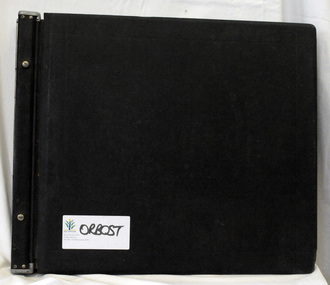
ledger, late 1950's - 1970's
... Roads Corporation. James Cameron, an Orbost farming pioneer and Member of the Legislative Assembly, fathered the Country Roads Board This item is a hand-written record of Orbost Shire Council accounts. It pre- dates computer records. The Shire of Orbost local council no longer exists having been absorbed by the East Gippsland Shire Council. ledger accounts shire-of-orbost country-roads-board bottom left corner - Orbost in black on a white East Gippsland Shire logo A black ledger with wooden covers. ...This ledger was used by the Shire of Orbost in the late 1950's - 1970's.The item was donated to Orbost & District Historical society from P.R.O.V. as a Place of Deposit (POD) item for safe keeping by a local history group or museum. The shire covered an area of 9,347 square kilometres and existed from 1892 until 1994 when it became part of the East Gippsland Shire Council. Orbost was at first included in the Bairnsdale Shire from 1882 and was later part of the Tambo Shire. Because of travelling distances the Croajingalong Shire was created in 1892 (name changed to Orbost Shire 17.2.1893 with James Cameron as the first Shire President. In 1994 it amalgamated to become part of East Gippsland Shire Council. The Country Roads Board was the government authority for the construction and maintenance of main roads in Victoria between 1913 and 1983. It was succeeded by the Road Construction authority on 1 July 1983 and later merged with the Road Traffic Authority on July 1 1989 to form the Roads Corporation. James Cameron, an Orbost farming pioneer and Member of the Legislative Assembly, fathered the Country Roads Board This item is a hand-written record of Orbost Shire Council accounts. It pre- dates computer records. The Shire of Orbost local council no longer exists having been absorbed by the East Gippsland Shire Council.A black ledger with wooden covers. It contains hand-written records of transactions between Orbost Shire Council and the Country Roads Board.bottom left corner - Orbost in black on a white East Gippsland Shire logoledger accounts shire-of-orbost country-roads-board -
 Orbost & District Historical Society
pamphlets, Princes Freeway - Orbost Section, 1976
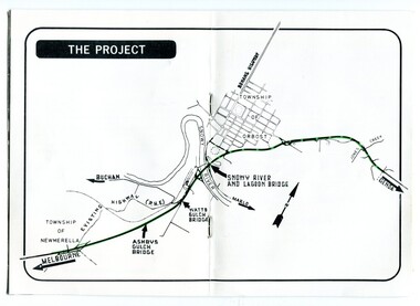
... Roads Corporation. James Cameron, an Orbost farming pioneer and Member of the Legislative Assembly, fathered the Country Roads Board. The opening of this Snowy River Bridge was an important development in the accessibility to the township of Orbost. Three coloured Country Roads pamphlets for the 'Princes Freeway - Orbost Section". On the front is a coloured photograph of the new construction over the Snowy River at Orbost. Inside is a program for a ceremony for the opening of the new Snowy River Bridge. There is also a black ...Opened by the Hon. J A Rafferty, Minister for Transport, 25 November 1976, the bridge was the first of four bridges to be built as part of the freeway bypass of Orbost. Construction cost $2.4 million. This construction was an important development along the Princes Highway corridor through East Gippsland. The original highway approached the Snowy River at a very poor alignment, and several serious accidents had occurred at the Orbost end. In times of heavy flood, the highway on both sides of the river had been cut by floodwaters and during the 1971 floods, the highest ever recorded, the river was a mile wide at the crossing. Construction of the bridges commenced in January 1975, with an expectation to open the bridge across the Snowy River as soon as possible. Less than two years later, on 25 November 1976, the bridge across the Snowy River was opened to traffic, allowing the old bridge to be demolished. The remainder of the Orbost Bypass, both the floodplain crossings and the eastern section around the township itself, was declared ‘Princes Freeway’ and opened to traffic in December 1977. (ref http://mrv.ozroads.com.au) The Country Roads Board was the government authority for the construction and maintenance of main roads in Victoria between 1913 and 1983. It was succeeded by the Road Construction authority on 1 July 1983 and later merged with the Road Traffic Authority on July 1 1989 to form the Roads Corporation. James Cameron, an Orbost farming pioneer and Member of the Legislative Assembly, fathered the Country Roads Board. The opening of this Snowy River Bridge was an important development in the accessibility to the township of Orbost.Three coloured Country Roads pamphlets for the 'Princes Freeway - Orbost Section". On the front is a coloured photograph of the new construction over the Snowy River at Orbost. Inside is a program for a ceremony for the opening of the new Snowy River Bridge. There is also a black print map of the project. -
 Orbost & District Historical Society
memorial document, 18th July, 1922
... Roads Board. James Cameron was an early Orbost pioneer, a respected community member and a prominent politician. Cameron-James-Orbost A memorial extract from the Victorian Parliamentary Debates. It is on white paper with black ...This is an extract from the Victorian Parliamentary Debates on Tuesday 18th July, 1922. It is titled "Death of the Honorable James Cameron" and is a tribute from Mr Lawson, the Victorian premier. In 1882 James Cameron was the first Orbost councillor of the newly constituted Tambo Shire. In the next twenty years he served as justice of the peace, shire councillor, guardian of St James's Anglican Church, Sunday school superintendent and president of the local agricultural society. In 1902 he won a by-election for Gippsland East and took his seat in the Legislative assembly. He serve for eighteen years and his main achievements were securing one million pounds for East Gippsland development bringing the railway to Orbost and establishing the Country Roads Board.James Cameron was an early Orbost pioneer, a respected community member and a prominent politician.A memorial extract from the Victorian Parliamentary Debates. It is on white paper with black print, a black border and is tied with black ribbon.cameron-james-orbost -
 Eltham District Historical Society Inc
Photograph, Fay Bridge, Former Glynn's Dairy Farm, Glynns Road, North Warrandyte, 31 August 2018
... Road where the big water tank is now situated on what was once James Orford’s property.) It was also destroyed Black Friday and she rebuilt it from the plans living in a caravan on site supervising the build. It was almost complete when she died May 1939. The property was bought by Evelyn Evans (a city girl) and her estranged husband in 1940. She had two sons, one only 9 months old at the time. It was a timber house with no power or water connected. The Ewen Cameron...Road where the big water tank is now situated on what was once James Orford’s property.) It was also destroyed Black Friday and she rebuilt it from the plans living in a caravan on site supervising the build. It was almost complete when she died May 1939. The property was bought by Evelyn Evans (a city girl) and her estranged husband in 1940. She had two sons, one only 9 months old at the time. It was a timber house with no power or water connected. The Ewen Cameron ...Glynn’s farm Originally Section 7, Parish of Nillumbik marked Aborigine Reserve in 1866 Crown Allotment 8, Section 7, Parish of Nillumbik, County of Evelyn, Certificate of Title Volume 4095, Folio 818.835, approx. 93 acres purchased by Joseph Panton in 1881 for £1/acre and known as Panton’s Point. By 1924 owned by S.S. Sergeant and called Riverswood. Sergeant commissioned Edna Walling to design the garden. In September 1929 the property was sold at auction by Mortgagee’s sale. Described as well built, brick, tile roof, Attic Villa containing downstairs 7 good rooms, bath, scullery, inside lavatory, etc. Upstairs 2 bedrooms and sleep out. Outbuildings compromising of brick and weatherboard wash house, stables, workshop, feed room, cow bails, large G.I. Hay shed, etc In January 1931 Riverswood property was proclaimed a sanctuary for native game for the entire year. A private swing bridge crossed the river at Pound Bend was known as Pearson’s bridge after C.W.K. Pearson who bought Riverswood in the early 1930s. The bridge was swept away in the December 1934 floods. Riverswood was sold by C.W.K. Pearson at auction on 25 November 1936. Described as a beautiful farm home of 93 acres and over one mile of River Yarra frontage, modern brick residence, lovely garden, rich river flat pastures, model poultry farm. The fine brick home was destroyed on Black Friday (13 Jan.) 1939. It was still a ruin when the Evelyn Evans purchased Waikowhane above Riverswood in 1940. The Glynn family purchased the Riverswood property in 1941 from Robert and Emily Hannon. Their son Kenneth Patrick Glynn inherited the property and he set about clearing the land during WW2 selling wood. Prior to marriage, Kenneth was living alone on the farm in a house he had built from whatever was available. He used the bluestone foundations from the original fine brick home. He met and married Honora Elizabeth Drew in early 1945 and their daughter Anna grew up on the farm. It was compulsorily acquired by the Board of Works in 1976 who then rented the house out in the 1980s. The property was transferred to Melbourne Parks and Waterways in 1996. Waikowhane was a pretty timber house built on top of the hill on 50 acres above Riverswood by retired nurse Jessie MacBeth. (This would be at the intersection of Glynns Road and Overbank Road where the big water tank is now situated on what was once James Orford’s property.) It was also destroyed Black Friday and she rebuilt it from the plans living in a caravan on site supervising the build. It was almost complete when she died May 1939. The property was bought by Evelyn Evans (a city girl) and her estranged husband in 1940. She had two sons, one only 9 months old at the time. It was a timber house with no power or water connected. The Ewen Cameron family bought Waikowhane in 1957. They had to evacuate when the 1961 bushfires swept through. The house was saved by Matcham Skipper. It was demolished by Melbourne Water in the 1990s when they acquired it.fay bridge collection, 2018-08-31, glynn's, glynn's dairy farm, glynns road, north warrandyte, parks victoria, ruins, riverswood, kenneth patrick glynn -
 Glen Eira Historical Society
Newspaper - GLENHUNTLY
... black and white photographs throughout the newspaper illustrate the subjects at hand. ‘Glenhuntly News’ Glenhuntly Primary School Primary Schools Fires Dolphin Bill St Anthony’s School Dalton Des Caulfield South Primary School Gardenvale Central Primary School Norman Peter Rubbish bins Koornang Road Shopping Centre Carnegie Neighbourhood Study Car Parks Caulfield City Council Homestead Handyman Hardware Hardware Stores Liberal Party Railway Crossings North Road Ormond Railway Station Strong Chris Mr. Kendall Press Norman Carol Ormond East Primary School Norman Stuart Norman Cameron ...This file contains one item pertaining to Glenhuntly: 1/A copy of the 11/1981, Vol. 1, No. 1 edition (that is, the first edition) of the Glenhuntly News, a local newspaper. Each of its 8 pages except pages 6 and 8 contain material of relevance to Glen Eira. Page 1 features 3 items: an article about the action taken in the wake of a fire occurring at Glenhuntly Primary School on 29/10/1981, a short article about Caulfield resident’s misuse of rubbish bins, and an article (continued on page 7) about the beautification of the Koornang Road Shopping Centre. Page 2 features 2 items: an advertisement for Homestead Handyman Hardware, and an article in which the Liberal candidate for the seat of Glenhuntly, Peter Norman, comments on the State Government’s decision not to extend trading hours for large retailer. Page 3 features 4 items: 2 advertisements for volunteer work for the regional branch of the Liberal Party, an article about the many difficulties people face using an underpass at a railway crossing in North Road, and an article describing the aims of the newly-established newspaper itself. Pages 4 and 5 feature 1 item: an article about Peter Norman; his life, work and opinions. Page 6 features 1 item: an article(continued on page 7) by three American children – Anita, Fabos and Adrian (surnames unspecified) – detailing their visit to Melbourne. There does not appear to be anything of relevance to Glen Eira. Page 7 features 5 items: the continuations of the articles from pages 1 and 6, an advertisement for a pool party for young Caulfield/Glenhuntly Liberals, an advertisement for an antiques sale, and an article about the establishment of a technical school on the site of former Holmesglen Construction Factory in Malvern (not relevant to Glen Eira). Page 8 features 2 items: an article about the three certificates the Royal Life Saving Society of Australia offers children for swimming competency, and an advertisement for an automobile called the Gemini Sandpiper II. Neither is relevant to Glen Eira). Numerous black and white photographs throughout the newspaper illustrate the subjects at hand.‘glenhuntly news’, glenhuntly primary school, primary schools, fires, dolphin bill, st anthony’s school, dalton des, caulfield south primary school, gardenvale central primary school, norman peter, rubbish bins, koornang road shopping centre, carnegie neighbourhood study, car parks, caulfield city council, homestead handyman hardware, hardware stores, liberal party, railway crossings, north road, ormond railway station, strong chris mr., kendall press, norman carol, ormond east primary school, norman stuart, norman cameron, estrella kindergarten, solway primary school, higgins electorate committee, higgins area finance committee, national stationers and office suppliers association, oakleigh chamber of commerce, anti-c3 action group (actag), haywood don, ireland jim, ramsay jim, gardner barry, sessler kurt, thompson lindsay, booran holden, glenhuntly road, caulfield -
Glen Eira Historical Society
Document - Mimosa Road, 91, Carnegie
... Glen Eira Historical Society 965 Glen Huntly Rd Caulfield VIC 3162 melbourne This file contains 4 items: 1/7 pages of real estate advertisement, including colour and black-and-white exterior and interior photographs, downloaded from realestate.com.au, on 17/09/2007 prior to auction of the property on 06/10/2007. 2/A copy of a black-and-white photograph of exterior with Eric Darke, aged approximately 6 years, son of the first owners ca. 1927. 3/A copy of a colour photograph of exterior with later altered veranda, dated January 1982. 4/Research notes dated 30/05/2014, handwritten by Peta Darke, concerning the house and family at 91 Mimosa Road. Carnegie Mimosa Road Brick Houses Koornang Road Hocking Stuart Staples Mark Darke Eric Darke Frank Mullis Darke Edna Joy Weeks Edna Clothier Peta Californian Bungalows Wattle Avenue Glen Huntly Architectural Styles Darke Ruth Marjorie Braden Ruth Marjorie Darke John Cameron Darke Frank MacAlister Darke Richard Alexander Darke Alison Joy Document Mimosa Road, 91, Carnegie ...This file contains 4 items: 1/7 pages of real estate advertisement, including colour and black-and-white exterior and interior photographs, downloaded from realestate.com.au, on 17/09/2007 prior to auction of the property on 06/10/2007. 2/A copy of a black-and-white photograph of exterior with Eric Darke, aged approximately 6 years, son of the first owners ca. 1927. 3/A copy of a colour photograph of exterior with later altered veranda, dated January 1982. 4/Research notes dated 30/05/2014, handwritten by Peta Darke, concerning the house and family at 91 Mimosa Road.carnegie, mimosa road, brick houses, koornang road, hocking stuart, staples mark, darke eric, darke frank mullis, darke edna joy, weeks edna, clothier peta, californian bungalows, wattle avenue, glen huntly, architectural styles, darke ruth marjorie, braden ruth marjorie, darke john cameron, darke frank macalister, darke richard alexander, darke alison joy -
 Eltham District Historical Society Inc
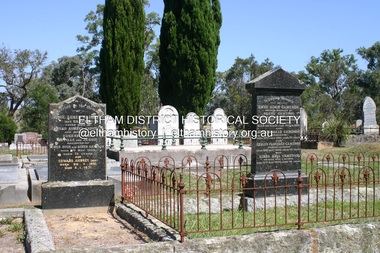
Photograph - Digital Photograph, Alan King, Cameron family graves, Kangaroo Ground Cemetery, Eltham-Yarra Glen Road, Kangaroo Ground, 28 January 2008
... Black Saturday bushfires of February 7, 2009, it documents sites that were impacted, and in some cases destroyed by the fires. It includes photographs taken especially for the publication, creating a unique time capsule representing the Shire in the early 21st century. It remains the most recent comprehenesive publication devoted to the Shire's history connecting local residents to the past. Nillumbik Now and Then (Marshall-King) Collection Kangaroo Ground Eltham-Yarra Glen Road Agnes Bell Cameron ...Six year old Judith Furphy was the first person known to have been buried at Kangaroo Ground Cemetery in May 1851. The cemetery is situated on an ancient river bed with exposed Nillumbik sands. The rest of the district is formed from black volcanic soil which was hard to dig. According to local historian Mick Woiwod (deceased) the site may have been a burial ground for the local Wurundjeri people as the exposed softer sands were always their prefered camping sites. The Hon. Ewen Hugh Cameron who lived at Pigeon Bank and was the Member for Evelyn for 40 years (1874-1914) was buried here in 1915. Published: Nillumbik Now and Then / Marguerite Marshall 2008; photographs Alan King with Marguerite Marshall.; p39 The Wurundjeri people might have buried their dead on the site of the Kangaroo Ground Cemetery, according to local historian Mick Woiwod. Kangaroo Ground was a premier hunting ground, but camping on the black volcanic soil would have been uncomfortable. Unlike most of Kangaroo Ground, its cemetery, on an ancient river bed, comprises a rare exposure of Nillumbik sands – always the preferred campsite for Aboriginal people. The cemetery area is the only place where the soil was soft enough to dig a grave easily.1 Six-year-old Judith Furphy was the first person known to have been laid to rest at the Kangaroo Ground Cemetery. She died on May 17, 1851, from a chill caught by resting on wet grass. Local Andrew Ross wrote ‘..no public burying place existed nearer than Melbourne. The case being considered urgent, a general meeting of the settlers took place on the evening of the 17th……. The result was the selection of unoccupied crown land …….which was subsequently granted by Government for a public cemetery.’2 Judith was buried the next day on May 18. Her grave was marked by the trustees with a plaque, which unfortunately states nine years old, when she was probably only six. Judith came from an illustrious family. Her brother, Joseph, was the author of Such is Life and other works. Another brother, John, developed and manufactured the famous Furphy water cart, which distributed water to World War One soldiers along with the latest rumours. Hence the name Furphy entered the Australian idiom, as synonymous with ‘rumour’. Judith’s father Samuel helped build the first Kangaroo Ground church school. Inside, near the entrance of the cemetery, on Yarra Glen Road, stand a rotunda and a water tank. Occasional benches invite mourners to pause and remember. The gate with wrought iron and brick supports, bears the inscription ‘Erected by Sir Ewen and Lady Cameron in memory of their daughter, Flora Margaret’. These are only two of the famous people connected with this cemetery. The Hon. Ewen Hugh Cameron JP and MLA from 1874 to1914, who lived at Pigeon Bank, Warrandyte Road, was buried here in 1915. Unrelated, but with the same name, was Sir Ewen Cameron who had been Minister for Health and was laid to rest there in 1964. Sir Herbert Gepp, a leading industrialist and the former owner of Garden Hill, at Yarra Glen Road, was buried there in 1954.3 Many of the more imposing tombstones belong to the earlier graves. Unfortunately bushfires have cracked several. But this adds to the melancholy attractiveness of the cemetery, graced by some beautiful eucalypts, cypress and pines. Early pioneering families represented at the cemetery include Armstrong, Barr, Bell, Harkness, Jardine, Johnston, Rogerson, Stevenson, Thomson and Walters. Armstrong and Bell were among the first families to come to the district and Stevenson owned the district’s first sheep station. It took in much of present day Christmas Hills, which was the name he gave his sheep station. Harkness was the first to suggest a Kangaroo Ground school be built, and one of the first to suggest establishing the Eltham District Road Board. Many of these families leased pastoral land before the mid-century and bought land when it came on sale in 1849. In the cemetery’s early days sections were devoted to the major Christian denominations (mainly the Protestant) and one section was set aside for ‘other’ or ‘non-believers’. However in modern times burial plots have not been placed in areas according to religious beliefs.This collection of almost 130 photos about places and people within the Shire of Nillumbik, an urban and rural municipality in Melbourne's north, contributes to an understanding of the history of the Shire. Published in 2008 immediately prior to the Black Saturday bushfires of February 7, 2009, it documents sites that were impacted, and in some cases destroyed by the fires. It includes photographs taken especially for the publication, creating a unique time capsule representing the Shire in the early 21st century. It remains the most recent comprehenesive publication devoted to the Shire's history connecting local residents to the past. nillumbik now and then (marshall-king) collection, kangaroo ground, eltham-yarra glen road, agnes bell cameron, agnes cameron (nee bell), cameron family, edward aubrey haughton, eugene cameron, evelyn florence cameron, ewen hugh cameron, gravestones, jane armstrong, jane bell, jessie agnes haughton (nee cameron), jessie cameron, john donald cameron, kangaroo ground cemetery, neville cameron, simon armstrong, vera cameron, william bell armstrong, wurundjeri -
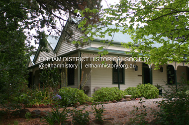
 Eltham District Historical Society Inc
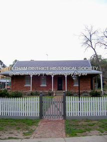
Photograph - Digital Photograph, Marguerite Marshall, Wingrove Cottage, Main Road, Eltham, 8 June 2006
... Black Saturday bushfires of February 7, 2009, it documents sites that were impacted, and in some cases destroyed by the fires. It includes photographs taken especially for the publication, creating a unique time capsule representing the Shire in the early 21st century. It remains the most recent comprehenesive publication devoted to the Shire's history connecting local residents to the past. Nillumbik Now and Then (Marshall-King) Collection Cameron Construction Charles Symons Wingrove Eltham eltham road ...Wingrove Cottage built 1858-1859 of hand made bricks is historically significant for its long association with Charles Wingrove, a prominent figure in Victorian local government, as secretary to the Eltham District Road Board and Shire Council from 1858 to 1904, and Shire Engineer and Secretary to the Heidelberg Road Board. The cottage was used as the office of the Eltham District Road Board and Council for many years It is one of the Shire's oldest dwellings, and one of the few surviving 19th century buildings associated with early Eltham and located in the original Eltham Village Reserve. The symmetrical planting of a pair of Pencil Pines (not visible in photo) is also historically and aesthetically significant as characteristic of the early period of planting in the district and because they are a distinctive landscape feature. In October 2002 new owners demolished the outbuildings attached to the rear of the cottage. Community protest at the demolition resulted in Council issuing a Stop Work order. The owner was issued with a court order in September 2003 to develop a conservation management plan and restore the heritage listed property. The owner sold the property in 2005 to Cameron Construction in 2005 who undertook the restoration work. In 2007 a planning application to build two offices and seven dwellings at the rear of the property was ultimately rejected. The cottage is now the main office for Cameron Construction. Covered under Heritage Overlay, Nillumbik Planning Scheme. Published: Nillumbik Now and Then / Marguerite Marshall 2008; photographs Alan King with Marguerite Marshall.; p57 Wingrove Cottage on Main Road beside Eltham Primary School, is one of the Shire’s most important historical buildings and was central to local government for almost 50 years. The cottage was built in stages from 1858 to 1888 for Charles Symons Wingrove JP. He was the Eltham District Road Board’s first paid secretary and later the Shire Secretary when the board became the Eltham Shire Council. Wingrove held those positions, and that of engineer for a time, for 46 years. He was also one of the main figures in the Municipal Association of Victoria. As Eltham’s first paid municipal officer, Wingrove used one room in his 11 – (originally two) roomed home, as the office for the board then the council. Meetings were held there from the late 1850s (as well as at more central locations) until Wingrove’s retirement in 1904. The cottage is a rare example of a local government office occupying a Road Board /Shire Secretary’s purpose-designed house. The cottage is also significant because it is the oldest largely intact building from the original Eltham township reserve (south of Dalton Street).1 The township had its origins in the 1848 Nillumbik Parish Plan and was one of the state’s earliest township reserves. The rectangular house of handmade bricks, roofed with grey slate tiles and with a veranda encompassing three sides, is reminiscent of those in the central goldfields including Castlemaine. Its overhanging eaves and gables were unlike houses in Melbourne at the time. Wingrove, who was born in 1827, had been a gold digger and a road surveyor. Impossible to imagine in today’s world, Wingrove was also the Shire of Heidelberg’s secretary and engineer for part of the time that he was secretary in Eltham. Living next door to the primary school was a mixed blessing. Wingrove and his wife Katherine, who had ten children, sent their eight surviving children to the school. But they had occasional disputes with the school authorities when their cattle wandered into the schoolyard. Eltham showed Charles Wingrove its appreciation of his services by giving him two illuminated addresses, one after ten years and the other at retirement. Wingrove died in 1905 aged 76 and was buried in the St Katherine’s Church of England cemetery in St Helena. His grave is surrounded by those of family members including his wife, Katherine and two babies, Henry, 12 months and Isobella, 15 months, who died in the mid-1860s. Cottage ownership passed to his wife, then to daughter Caroline and then to daughter Bessie, a Melbourne University graduate and artist. During the Great Depression their brother Walter was the ratepayer. At one stage the Wingrove property extended to Metery Road and included a small creek. The family ran a small dairy and orchard, with associated farm buildings, which were later removed. In 1949 part of the property was compulsorily acquired by the Eltham Primary School, which infuriated owner Bessie Wingrove. She protested in a letter about this ‘monstrous act of unmitigated tyranny’.2 She was the last Wingrove to occupy the cottage and died in 1955. Wingrove descendants sold the house in 1974 and the property was subdivided. In the 1960s the Eltham Shire named the park opposite the cottage in Wingrove’s honour. The cottage has since had several owners including psychiatrist Dr Daniel Kahans, who practised there. In October 2002 late rear additions which had been substantially altered were demolished contrary to council planning controls. This caused a community outcry and resulted in legal proceedings against the owner. Fortunately the historical significance of the demolished section was not as great as the older front part of the building, which has been retained and was later restored.This collection of almost 130 photos about places and people within the Shire of Nillumbik, an urban and rural municipality in Melbourne's north, contributes to an understanding of the history of the Shire. Published in 2008 immediately prior to the Black Saturday bushfires of February 7, 2009, it documents sites that were impacted, and in some cases destroyed by the fires. It includes photographs taken especially for the publication, creating a unique time capsule representing the Shire in the early 21st century. It remains the most recent comprehenesive publication devoted to the Shire's history connecting local residents to the past. nillumbik now and then (marshall-king) collection, cameron construction, charles symons wingrove, eltham, eltham road district board, eltham shire council, main road, wingrove cottage -
 Eltham District Historical Society Inc
Photograph - Digital Photograph, Alan King, Pigeon Bank, Kangaroo Ground-Warrandyte Road, Kangaroo Ground, 6 February 2008
... Black Saturday bushfires of February 7, 2009, it documents sites that were impacted, and in some cases destroyed by the fires. It includes photographs taken especially for the publication, creating a unique time capsule representing the Shire in the early 21st century. It remains the most recent comprehenesive publication devoted to the Shire's history connecting local residents to the past. Nillumbik Now and Then (Marshall-King) Collection ewen hugh cameron Francis Rogerson Kangaroo Ground Kangaroo Ground-Warrandyte Road ...In 1848, Francis Rogerson form Dumfriesshire, Scotland purchased 80 acres of land at Kangaroo Ground on which he built a two-roomed bark hut. He named the property afterr the many Bronzewings and Wonga Pigeons in the area. Ewen Hugh Cameron moved to Pigeon Bank the same year he was elected to Parliament as the Member for Evelyn. At the time he moved in, Pigeon Bank had six rooms and the present water well. He made further extensive additions and lived there until his death in 1915. Covered under Heritage Overlay, Nillumbik Planning Scheme. Published: Nillumbik Now and Then / Marguerite Marshall 2008; photographs Alan King with Marguerite Marshall.; p27 Pigeon Bank, on the Kangaroo Ground – Warrandyte Road, Kangaroo Ground, is one of the Shire’s oldest farm dwellings, and has been home to some of the district’s earliest and most distinguished families. Although close to the road, the white weatherboard Victorian farmhouse is ensured privacy by the trees and hedges around it. On 4.8 hectares of farmland, Pigeon Bank is surrounded by rolling hills, farmland and bush, the peace of which is punctuated by an occasional birdcall. Pigeon Bank’s first owner was Francis Rogerson, from Dumfriesshire, Scotland, who bought 80 acres (32.4ha) of land in 1848 on which he built a two-roomed bark hut. Today this is the centre piece of the 14-room home.1 Rogerson lined the rooms with tongue-and-groove boards and roofed them with wooden shingles and sapling frames, which remain under the present green corrugated iron roof. He named Pigeon Bank after the many forest bronzewing and Wonga Pigeons in the area at the time, and the name Bank was commonly used in Scotland. Rogerson was united with one of the oldest families in the area when his sister Janet married John Bell, son of William, the original Bell settler. When Ewen Cameron moved to Pigeon Bank in 1874 it had six rooms and the present water well. He made extensive additions to the house and farm buildings and lived at Pigeon Bank until his death in 1915. Cameron, who had arrived in Melbourne from Scotland in 1853, contributed an enormous amount to the community. He worked as a builder, as a miner at Andersons Creek, a storekeeper at Queenstown2 and as the first postmaster at Warrandyte. In 1867 he married Agnes Bell, daughter of local farmer, John Bell. Cameron was a member of the Eltham Road Board (which preceded the Shire Council) and for more than 50 years, from 1863, he was an Eltham Shire Councillor, being President three times. Cameron was the Member for Evelyn for 40 years from 1874. In the 1880s he became the Government Whip, in 1902 the Minister for Mines and Water Supply, and in 1904, the Minister for Health, Cameron was also an outstanding farmer, whose farm won the Agricultural Department prize for the finest in the district, three consecutive times. Not surprisingly Pigeon Bank became the centre of district life. Every New Year’s Eve, Cameron hired a highland piper, who marched from the Kangaroo Ground school house to Pigeon Bank playing his pipes.3 Distinguished visitors included opera singer, Dame Nellie Melba, Victorian Premier, Thomas Bent, Governor, Lord Hopetoun and artist, Longstaff. Following Cameron’s death, the property changed hands several times, then returned to the family in 1919 when bought by Gordon Cameron. As the car took over from the horse, Pigeon Bank entered difficult times because the farm had produced chaff and oats and bred Clydesdales and harness ponies. In 1926 Mr Matthews bought the property and made many alterations including pulling down the kitchen, which had been separate from the main house. The property again changed hands several times. One owner was Senator James F Guthrie, who added a sunroom. In 1968 the house again returned to the Cameron family, when Vera Jackson, a grand-daughter of Ewen Cameron, and her husband, bought the property. The Bishop family, who were sixth and seventh generation Bells and also descended from the Camerons, restored the house in the 1980s. Today tongue-and-groove boards still line part of the hall (which retains two fine arches), the breakfast room, and Ewen Cameron’s former room. Five original fireplaces in the bed and living rooms are still in working order. The wide veranda with a curved iron roof and ornate iron lace work bounds three sides of the house, and nearby a windmill stands beside the water well. Sue and Ron James, who bought the property in 2001, made extensive improvements to the homestead and meticulously restored the grounds to their original state.This collection of almost 130 photos about places and people within the Shire of Nillumbik, an urban and rural municipality in Melbourne's north, contributes to an understanding of the history of the Shire. Published in 2008 immediately prior to the Black Saturday bushfires of February 7, 2009, it documents sites that were impacted, and in some cases destroyed by the fires. It includes photographs taken especially for the publication, creating a unique time capsule representing the Shire in the early 21st century. It remains the most recent comprehenesive publication devoted to the Shire's history connecting local residents to the past. nillumbik now and then (marshall-king) collection, ewen hugh cameron, francis rogerson, kangaroo ground, kangaroo ground-warrandyte road, pigeon bank -
 Eltham District Historical Society Inc
Photograph - Digital Photograph, Alan King, Pigeon Bank, one of the Nillumbik shire's oldest farm dwellings, 6 February 2008
... Black Saturday bushfires of February 7, 2009, it documents sites that were impacted, and in some cases destroyed by the fires. It includes photographs taken especially for the publication, creating a unique time capsule representing the Shire in the early 21st century. It remains the most recent comprehenesive publication devoted to the Shire's history connecting local residents to the past. Nillumbik Now and Then (Marshall-King) Collection ewen hugh cameron Francis Rogerson Kangaroo Ground Kangaroo Ground-Warrandyte Road ...In 1848, Francis Rogerson form Dumfriesshire, Scotland purchased 80 acres of land at Kangaroo Ground on which he built a two-roomed bark hut. He named the property afterr the many Bronzewings and Wonga Pigeons in the area. Ewen Hugh Cameron moved to Pigeon Bank the same year he was elected to Parliament as the Member for Evelyn. At the time he moved in, Pigeon Bank had six rooms and the present water well. He made further extensive additions and lived there until his death in 1915. Covered under Heritage Overlay, Nillumbik Planning Scheme. Published: Nillumbik Now and Then / Marguerite Marshall 2008; photographs Alan King with Marguerite Marshall.; p27This collection of almost 130 photos about places and people within the Shire of Nillumbik, an urban and rural municipality in Melbourne's north, contributes to an understanding of the history of the Shire. Published in 2008 immediately prior to the Black Saturday bushfires of February 7, 2009, it documents sites that were impacted, and in some cases destroyed by the fires. It includes photographs taken especially for the publication, creating a unique time capsule representing the Shire in the early 21st century. It remains the most recent comprehenesive publication devoted to the Shire's history connecting local residents to the past. nillumbik now and then (marshall-king) collection, ewen hugh cameron, francis rogerson, kangaroo ground, kangaroo ground-warrandyte road, pigeon bank -
 Greensborough Historical Society
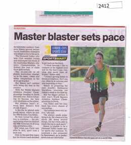
Newspaper Clipping, Master blaster sets pace, 23/09/2015
... Greensborough Historical Society 34A Glenauburn Road Lower Plenty Lower Plenty melbourne Bundoora resident Cameron Simon claimed 3 gold medals in the Australian Masters Athletics Championship. cameron simon diamond valley athletics club News clipping, black text, colour image. ...Bundoora resident Cameron Simon claimed 3 gold medals in the Australian Masters Athletics Championship.News clipping, black text, colour image.cameron simon, diamond valley athletics club -
 Greensborough Historical Society
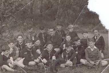
Photograph - Digital image, Gary Partington's Scout troop, 1953_
... Road Lower Plenty Lower Plenty melbourne Photograph of a Greensborough scout troop in 1953. Includes from the left: Gary Partington, Anthony Jerome, Scout Master Bob Barling, Francis Richards, John Barton Second Back Row from left: Ken Frye, Unknown, Unknown, Whelan? (front of Scout Master), then David Vickers, Unknown and Lew Cameron. Front from left: Tommy Malone and Doug Dickson. The photo was taken when Gary Partington was about 10. Also scan of Gary's scout badge. scouts - greensborough gary partington Digital copy of black ...Photograph of a Greensborough scout troop in 1953. Includes from the left: Gary Partington, Anthony Jerome, Scout Master Bob Barling, Francis Richards, John Barton Second Back Row from left: Ken Frye, Unknown, Unknown, Whelan? (front of Scout Master), then David Vickers, Unknown and Lew Cameron. Front from left: Tommy Malone and Doug Dickson. The photo was taken when Gary Partington was about 10. Also scan of Gary's scout badge.Digital copy of black and white photograph. Scan of scout badge.scouts - greensborough, gary partington -
 Greensborough Historical Society
Booklet, First aid, 1960s
... Road Lower Plenty Lower Plenty melbourne Smith & Nephew gave these booklets to users of their products. They were manufacturers of bandages and surgical dressings. first aid Rubber stamp: "A. R. Cameron Pty Ltd, 154 Moray Street South Melbourne" 27 page booklet, red cover, black ...Smith & Nephew gave these booklets to users of their products. They were manufacturers of bandages and surgical dressings.27 page booklet, red cover, black text and colour illustrationsRubber stamp: "A. R. Cameron Pty Ltd, 154 Moray Street South Melbourne"first aid -
 Greensborough Historical Society
Memorabilia - Program, Shire of Whittlesea et al, Shire of Whittlesea Reception Programme, and City of Doncaster and Templestowe civic luncheon 1972, 1972
... Road Lower Plenty Lower Plenty melbourne Programme cards for Shire of Whittlesea Reception hosted by Mrs V. R. Michael on 28th March 1972; and, City of Doncaster and Templestowe Civic Luncheon hosted by Mrs L. J. Cameron on 26th April 1972. Bruce Morgan was the first Shire Secretary (1964-1983) of the Shire of Diamond Valley. This collection was compiled by his wife, Mavis Morgan, detailing the events they attended in their official capacity bruce morgan mavis morgan shire of whittlesea city of doncaster and templestowe 1. Cream card with black ...Programme cards for Shire of Whittlesea Reception hosted by Mrs V. R. Michael on 28th March 1972; and, City of Doncaster and Templestowe Civic Luncheon hosted by Mrs L. J. Cameron on 26th April 1972.Bruce Morgan was the first Shire Secretary (1964-1983) of the Shire of Diamond Valley. This collection was compiled by his wife, Mavis Morgan, detailing the events they attended in their official capacity1. Cream card with black text and logo, 2. Cream card with green text and logobruce morgan, mavis morgan, shire of whittlesea, city of doncaster and templestowe -
 Eltham District Historical Society Inc
Slide - Photograph, Kangaroo Ground Cemetery, Cemetery Road, Kangaroo Ground, 27 May 1990
... He travelled on to St Katherines, St Helena, where he talked on the history of the church and cemetery. shire of eltham historical society cemetery excursion graves activities kangaroo ground cemetery Agnes Bell Cameron Evelyn Florence Cameron ewen hugh cameron John Donald Cameron 35mm colour positive transparency (1 of 23) Mount - Agfachrome Agfa CS System black 8 dots Kangaroo Ground Cemetery, Cemetery Road, Kangaroo Ground Slide Photograph ...Local Cemetery Excursion Sunday 27 May 1990 departed Eltham Shire Office at 9.30am and finish mid afternoon. Visits to Eltham , Kangaroo Ground, Queenstown (Smiths Gully), Nillumbik (Diamond Creek), St Katherines (St Helena) Hurst family graves at Hurstbridge and a little known early cemetery at Grteensborough. Attended by 20 members. In each case we were introduced to the cemetery with a brief talk. At Eltham, Frank Burgoyne gave us the benefit of his knowledge as a member of the cemetery trust and at Kangaroo Ground, Bruce Ness spoke in a similar capacity. The lunch stop was at Hurstbridge where we visited the Hurst family graves. The President of Nillumbik Historical Society, Jock Ryan, joined us at the Nillumbik (Diamond Creek) cemetery. He travelled on to St Katherines, St Helena, where he talked on the history of the church and cemetery.35mm colour positive transparency (1 of 23) Mount - Agfachrome Agfa CS System black 8 dotsshire of eltham historical society, cemetery excursion, graves, activities, kangaroo ground cemetery, agnes bell cameron, evelyn florence cameron, ewen hugh cameron, john donald cameron -
 Eltham District Historical Society Inc
Photograph, Sherbourne Road, Para Road and Simms Road at Briar Hill/Montmorency prior to the upgrade of Sherbourne Road Railway bridge, c.1970
... Road Railway bridge, c.1970. Photo 01648_ 19 This home owned by Mrs Cameron. Her daughter married a Mr Davey, for whom Davey Road was named - email from M. Jones 20/07/2015 Photographer unknown These photos are very significant in the documentation of the development of the Briar Hill and Montmorency areas and the changes in the physical landscape along the railway line area. 1970 briar hill davey road montmorency para road cameron davey sherbourne road simms road railway line roadworks 20 black and white prints 9 cm x 13 cm. ...Collection of photographs probably taken around the same time depicting Sherbourne Road, Para Road and Simms Road at Briar Hill/Montmorency prior to the upgrade of Sherbourne Road Railway bridge, c.1970. Photo 01648_ 19 This home owned by Mrs Cameron. Her daughter married a Mr Davey, for whom Davey Road was named - email from M. Jones 20/07/2015 Photographer unknownThese photos are very significant in the documentation of the development of the Briar Hill and Montmorency areas and the changes in the physical landscape along the railway line area.20 black and white prints 9 cm x 13 cm.1970, briar hill, davey road, montmorency, para road, cameron, davey, sherbourne road, simms road, railway line, roadworks -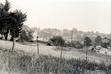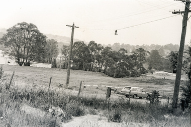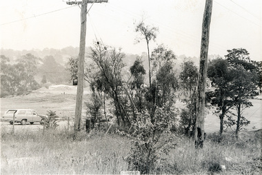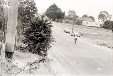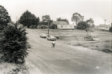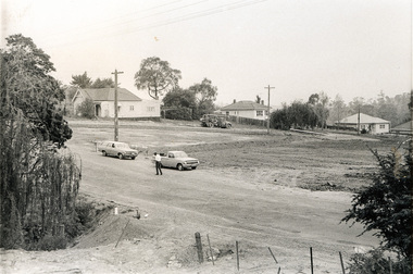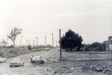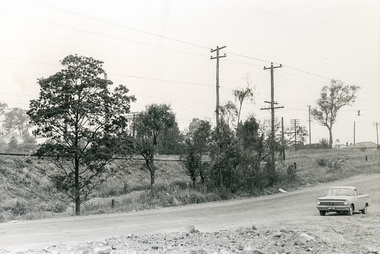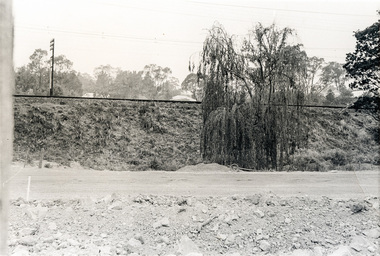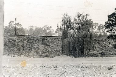
 Eltham District Historical Society Inc
Photograph, Sherbourne Road, Para Road and Simms Road at Briar Hill/Montmorency prior to the upgrade of Sherbourne Road Railway bridge, c.1970
... Road Railway bridge, c.1970. Photo 01648_ 19 This home owned by Mrs Cameron. Her daughter married a Mr Davey, for whom Davey Road was named - email from M. Jones 20/07/2015 Photographer unknown These photos are very significant in the documentation of the development of the Briar Hill and Montmorency areas and the changes in the physical landscape along the railway line area. 1970 briar hill davey road montmorency para road cameron davey sherbourne road simms road railway line roadworks 20 black and white prints 9 cm x 13 cm. ...Collection of photographs probably taken around the same time depicting Sherbourne Road, Para Road and Simms Road at Briar Hill/Montmorency prior to the upgrade of Sherbourne Road Railway bridge, c.1970. Photo 01648_ 19 This home owned by Mrs Cameron. Her daughter married a Mr Davey, for whom Davey Road was named - email from M. Jones 20/07/2015 Photographer unknownThese photos are very significant in the documentation of the development of the Briar Hill and Montmorency areas and the changes in the physical landscape along the railway line area.20 black and white prints 9 cm x 13 cm.1970, briar hill, davey road, montmorency, para road, cameron, davey, sherbourne road, simms road, railway line, roadworks