Showing 18 items matching "blue stone bridge"
-
 Greensborough Historical Society
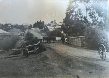
Photograph - Photograph (Framed), Herding stock over blue stone bridge looking up Main Street Greensborough
... Herding stock over blue stone bridge looking up Main Street Greensborough......blue stone bridge...Heading stock over Blue stone bridge looking up Main Street Greensborough. ...Timber-framed photograph of herding stock over blue stone bridge looking up Main Street Greensborough, black and white....Greensborough Historical Society 34A Glenauburn Road Lower Plenty Lower Plenty melbourne Heading stock over Blue stone bridge looking up Main Street Greensborough. ...Heading stock over Blue stone bridge looking up Main Street Greensborough. In this photograph, Greensborough was a country town. Note the unmade road leading up to the bridge.From the John Mackey collection. This item was displayed at the offices of Ryan, Mackey and Kelly, solicitors, Main Street Greensborough.Timber-framed photograph of herding stock over blue stone bridge looking up Main Street Greensborough, black and white.greensborough, john mackey, blue stone bridge, marble hall -
 Greensborough Historical Society
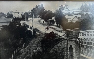
Photograph - Photograph (Framed), Blue stone bridge looking up Main Street Greensborough
... Blue stone bridge looking up Main Street Greensborough......blue stone bridge...Blue stone bridge looking up Main Street Greensborough. ...Greensborough Historical Society 34A Glenauburn Road Lower Plenty Lower Plenty melbourne Blue stone bridge looking up Main Street Greensborough. ...Blue stone bridge looking up Main Street Greensborough. Bridge lower right and Marble Hall upper left.From the John Mackey collection. this item was displayed at the offices of Ryan, Mackey and Kelly, solicitors, Main Street Greensborough.Timber-framed photograph of view of Greensborough, black and white.greensborough, john mackey, blue stone bridge, marble hall -
 Greensborough Historical Society
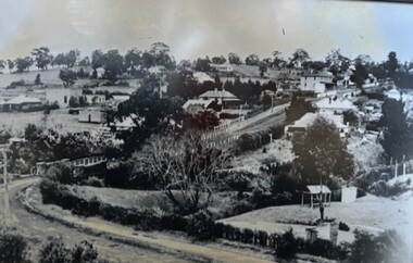
Photograph - Photograph (Framed), Greensborough from Diamond Creek Road
... ...blue stone bridge...Greensborough Historical Society 34A Glenauburn Road Lower Plenty Lower Plenty melbourne Greensborough from Diamond Creek Road, includes a view of lower Main Street and lower park From the John Mackey collection. this item was displayed at the offices of Ryan, Mackey and Kelly, solicitors, Main Street Greensborough. greensborough John Mackey blue stone bridge marble hall Timber-framed photograph of view of Greensborough from Diamond Creek Road, black and white. ...Greensborough from Diamond Creek Road, includes a view of lower Main Street and lower parkFrom the John Mackey collection. this item was displayed at the offices of Ryan, Mackey and Kelly, solicitors, Main Street Greensborough.Timber-framed photograph of view of Greensborough from Diamond Creek Road, black and white.greensborough, john mackey, blue stone bridge, marble hall -
 Greensborough Historical Society
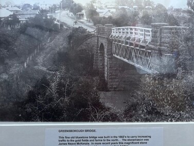
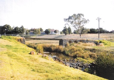
Photograph - Photograph (Framed), Greensborough bridge, 1870s
... ...blue stone bridge...bridge was built in the 1860s to carry increasing traffic to the gold fields and farms to the north. The stonemason was James Neave McKenzie. In more recent years this magnificent stone structure had to be replaced by a more modern bridge." From the John Davidson collection. John Davidson mckenzie bridge greensborough blue ...Greensborough bridge caption reads: "This fine old bluestone bridge was built in the 1860s to carry increasing traffic to the gold fields and farms to the north. The stonemason was James Neave McKenzie. In more recent years this magnificent stone structure had to be replaced by a more modern bridge."From the John Davidson collection.Photograph in black plastic frame with typed caption on matte.john davidson, mckenzie bridge, greensborough, blue stone bridge -
 Sunbury Family History and Heritage Society Inc.
Photograph, Bulla Bridge, c 1980s
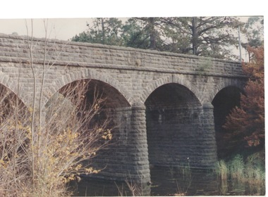
... A non-digital coloured close - up photograph of a four-arched blue stone bridge spanning a waterway. Some greenery is visible on either side of the bridge and above it. ...A non-digital coloured close - up photograph of a four-arched blue stone bridge spanning a waterway. Some greenery is visible on either side of the bridge and above it. ...The bridge in the photograph is the bluestone bridge at Bulla which spans the Deep Creek, a tributary of the Maribyrnong River. It was built in 1869 and replaced a ford crossing which was built further downstream. Many of the buildings and structures in the area were built from bluestone which is in abundance throughout this volcanic area.This bridge is one of many similar structures built across Western Victoria where the bluestone volcanic rock was found in abundance. It has been classified as being of local heritage significance.A non-digital coloured close - up photograph of a four-arched blue stone bridge spanning a waterway. Some greenery is visible on either side of the bridge and above it. bulla bridge, bluestone, bridges, deep creek. -
 Whitehorse Historical Society Inc.
Postcard - Black and white postcard, Blackburn Road Circa 1908, C1914
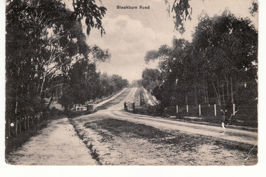
... Looking north|Known as Halley's Bridge.|Demolished in 1965.|Blue stones from bridge used in garden of Lynette Letcher in Clovely Court Blackburn....Looking north|Known as Halley's Bridge.|Demolished in 1965.|Blue stones from bridge used in garden of Lynette Letcher in Clovely Court Blackburn. ...Black and white postcard entitled 'Blackburn Road'. Scene shows bridge over unmade road and heavily treed sides. Looking north|Known as Halley's Bridge.|Demolished in 1965.|Blue stones from bridge used in garden of Lynette Letcher in Clovely Court Blackburn.blackburn road, blackburn, hooke, albert arthur, halley's bridge, bridges, letcher lynette -
 Eltham District Historical Society Inc
Book, Irene Turvey et al, Greensborough and Greenhills / words by Irene Turvey ; Drawings by Ron Reynolds, 1973
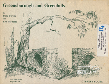
... Contents cover : Blue stone bridge, Introduction, House cnr Church and Hailes Street, House - 25 Hailes Street, Yandell Reserve, Greensborough Hotel, Lobb's Kiosk, House - 49 Grimshaw Street, View of Greensborough (from Delphin Crescent), Railway Station, Old Barn (near Greensborough Railway Station), Partington's Flat and River Valley, Rand Street Bridge, Lower Main Street, Greenbriar Nursery, Hitching rail, Ashmead - Dr Cordner's Home, Greensborough Primary School, House - cnr St Helena and Diamond Creek Raods, Sondermeyer's Hill, Methodist Church, Football Pavilion, Cemetery, St Katherine's Church, St. ...Contents cover : Blue stone bridge, Introduction, House cnr Church and Hailes Street, House - 25 Hailes Street, Yandell Reserve, Greensborough Hotel, Lobb's Kiosk, House - 49 Grimshaw Street, View of Greensborough (from Delphin Crescent), Railway Station, Old Barn (near Greensborough Railway Station), Partington's Flat and River Valley, Rand Street Bridge, Lower Main Street, Greenbriar Nursery, Hitching rail, Ashmead - Dr Cordner's Home, Greensborough Primary School, House - cnr St Helena and Diamond Creek Raods, Sondermeyer's Hill, Methodist Church, Football Pavilion, Cemetery, St Katherine's Church, St. ...Pen and ink sketches accompanied by appropriate text in double page spreads. Contents cover : Blue stone bridge, Introduction, House cnr Church and Hailes Street, House - 25 Hailes Street, Yandell Reserve, Greensborough Hotel, Lobb's Kiosk, House - 49 Grimshaw Street, View of Greensborough (from Delphin Crescent), Railway Station, Old Barn (near Greensborough Railway Station), Partington's Flat and River Valley, Rand Street Bridge, Lower Main Street, Greenbriar Nursery, Hitching rail, Ashmead - Dr Cordner's Home, Greensborough Primary School, House - cnr St Helena and Diamond Creek Raods, Sondermeyer's Hill, Methodist Church, Football Pavilion, Cemetery, St Katherine's Church, St. Helena, Civic Centre, Briar Hill Timber Mill, 24 River Street, Kelly's Garden Supplies, 158 Main Street, Old Swimming pool, 105 Main Street.Hardback; 62 p. : ill., map ; 19 x 25 cm.ISBN 0909807108 Signed by author and illustrator Two copiesgreenhills, greensborough -
 Sunshine and District Historical Society Incorporated
Archive - Places of Historic Interest in and around St Albans 2013, Missen Alie Compiler
... Places of Historic Interest in and around St Albans|The ABC Radio mast and transmitter station|The Blue stone Culvert bridge|Sydenham railway station|Robertsons Upper Keilor Homestead|A Sheep Dip|The Overnewton Venue|The Overnewton Gatehouse|Anderson Cottage|the Hume and Hovell Cairn| Keighlo|St Albans Railway Reserve Grasslands|The Anderson Farm House|The St George Fee Serbian Orthodox Church|The Agnes Stevens farmhouse|The Stensons Family Farm|The Errington Reserve Gates|The St Albans Community Youth Centre|St Albans Town Plan|St Albans Uniting Church...Albans Harrsion Places of Historic Interest in and around St Albans|The ABC Radio mast and transmitter station|The Blue stone Culvert bridge|Sydenham railway station|Robertsons Upper Keilor Homestead|A Sheep Dip|The Overnewton Venue|The Overnewton Gatehouse|Anderson Cottage|the Hume and Hovell Cairn| Keighlo|St Albans Railway Reserve Grasslands|The Anderson Farm House|The St George Fee Serbian Orthodox Church|The Agnes Stevens farmhouse|The Stensons Family Farm|The Errington Reserve Gates|The St Albans Community Youth Centre|St Albans Town Plan|St Albans Uniting Church Places of Historic Interest in and around St Albans 2013 Compiled by Alie Missen Archive Places of Historic Interest in and around St Albans 2013 Missen Alie Compiler ...Places of Historic Interest in and around St Albans|The ABC Radio mast and transmitter station|The Blue stone Culvert bridge|Sydenham railway station|Robertsons Upper Keilor Homestead|A Sheep Dip|The Overnewton Venue|The Overnewton Gatehouse|Anderson Cottage|the Hume and Hovell Cairn| Keighlo|St Albans Railway Reserve Grasslands|The Anderson Farm House|The St George Fee Serbian Orthodox Church|The Agnes Stevens farmhouse|The Stensons Family Farm|The Errington Reserve Gates|The St Albans Community Youth Centre|St Albans Town Plan|St Albans Uniting Churchst. albans, harrsion -
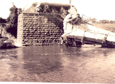 Federation University Historical Collection
Photograph - Photographs, Richard Vincent, Washed Away Bridge at Garibaldi, c1933
... Three black and white photographs showing flood damage to the bridge over the Leigh River at Garibaldi, plus a photocopy of a newspaper clipping from The Argus December 1933 describing the extent of the flood damage. .1) shows blue stone buttress and collapsed bridge/road. .2) mirror image of above .3) unknown man waling an a girder of the Garibaldi bridge .4) photocopy of newspaper clipping about flood damage from The Argus December 1933...stone and concrete bridge over the Leigh River at Garibaldi in the Buninyong Shire. The concrete slabs were still in the water in the 1960s/70s or even later. leigh river garibaldi buninyong shire richard vincent garibaldi bridge Damage by Floods: Bridges washed away (The Argus December 1933) Three black and white photographs showing flood damage to the bridge over the Leigh River at Garibaldi, plus a photocopy of a newspaper clipping from The Argus December 1933 describing the extent of the flood damage. .1) shows blue stone buttress and collapsed bridge/road. .2) mirror image of above .3) unknown man waling an a girder of the Garibaldi bridge .4) photocopy of newspaper clipping about flood damage from The Argus December 1933 Washed Away Bridge at Garibaldi Photograph Photographs Richard Vincent ...Newspaper clipping documents deputations to the Minister of Public Works for grants to be made available for repairs to bridges and roads damaged by heavy flooding in 1933, in particular, the replacement of a stone and concrete bridge over the Leigh River at Garibaldi in the Buninyong Shire. The concrete slabs were still in the water in the 1960s/70s or even later. Three black and white photographs showing flood damage to the bridge over the Leigh River at Garibaldi, plus a photocopy of a newspaper clipping from The Argus December 1933 describing the extent of the flood damage. .1) shows blue stone buttress and collapsed bridge/road. .2) mirror image of above .3) unknown man waling an a girder of the Garibaldi bridge .4) photocopy of newspaper clipping about flood damage from The Argus December 1933Damage by Floods: Bridges washed away (The Argus December 1933)leigh river, garibaldi, buninyong shire, richard vincent, garibaldi bridge -
 Glenelg Shire Council Cultural Collection
Card - Card / Photo - Melbourne Photography Company, n.d
... Glenelg Shire Council Cultural Collection History House Cliff Street Portland great-ocean-road Back: Piece of masking tape, top edge of card, with GRANDFATHER VIVIAN' hand printed, blue biro Burgundy card with black and white photo attached to front. Young man in formal attire standing next to stone wall, hand on urn. 'Melbourne Photography Company BRIDGE ...Burgundy card with black and white photo attached to front. Young man in formal attire standing next to stone wall, hand on urn. 'Melbourne Photography Company BRIDGE STREET BALLARAT' printed in gold, beneath photBack: Piece of masking tape, top edge of card, with GRANDFATHER VIVIAN' hand printed, blue biro -
 Coal Creek Community Park & Museum
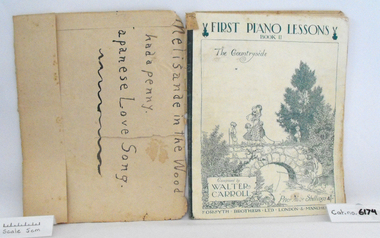
Music Book, First Piano Lessons, Book II, The Countryside
... Music book "First Piano Lessons, Book II, The Countryside", Composed by Walter Carroll, covered in brown discoloured paper, original cover has a white background with charming illustration of children walking over stone bridge and fishing in the river, printed in blue.....Coal Creek Community Park & Museum 12 Silkstone Road Korumburra gippsland Music book "First Piano Lessons, Book II, The Countryside", Composed by Walter Carroll, covered in brown discoloured paper, original cover has a white background with charming illustration of children walking over stone bridge and fishing in the river, printed in blue.. First Piano Lessons, Book II, The Countryside Music Book ...Music book "First Piano Lessons, Book II, The Countryside", Composed by Walter Carroll, covered in brown discoloured paper, original cover has a white background with charming illustration of children walking over stone bridge and fishing in the river, printed in blue.. -
 Sunshine and District Historical Society Incorporated
Photograph - Beattys Road Bridge Rockbank Photographs, John Alchin, 2008
... One of the photographs captures a Terrestrial Road surface (Local Blue Stone), one of the district's early sealed section of road. Beatty's Road Rockbank Rockbank Inn Terrestrial Road 5644.01 - Beattys Road Bridge Rockbank 2008 Photo 01.JPG 5644.02 - Beattys Road Bridge Rockbank 2008 Photo 02.JPG 5644.03 - Beattys Road Terrestrial Road Surface Rockbank 2008 Photo 04.JPG 5644.04 - Beattys Road Paddocks Rockbank 2008 Photo 03.JPG Collection of digital photographs Photograph Beattys Road Bridge Rockbank Photographs John Alchin ...Rockbank was once part of the Braybrook Road District. In, 1871 the Road District became the Shire of Braybrook. In 1916, this district was transferred to the Shire of Melton. In 1951, further land was lost to the Shire of Melton. During the early days of the Ballarat gold rush, Beatty's Road was one of the main routes from Melbourne to Ballarat via Keilor . In December 1854, troops of the 12th and 40th Regiments marching to suppress the Eureka Stockade would have used this route before stopping at the Rockbank Inn, which was located on Beatty's Road, further west towards Melton. One of the photographs captures a Terrestrial Road surface (Local Blue Stone), one of the district's early sealed section of road. 5644.01 - Beattys Road Bridge Rockbank 2008 Photo 01.JPG 5644.02 - Beattys Road Bridge Rockbank 2008 Photo 02.JPG 5644.03 - Beattys Road Terrestrial Road Surface Rockbank 2008 Photo 04.JPG 5644.04 - Beattys Road Paddocks Rockbank 2008 Photo 03.JPGbeatty's road, rockbank, rockbank inn, terrestrial road -
 Sunshine and District Historical Society Incorporated
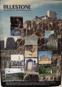
Poster - Bluestone Melbourne's Western Region - Bluestone & basalt quarried rocks in buildings Poster, Living Museum of the West, 1988
... Blue Stone Bluestone Melbourne's Western Region|Dean Bloxidhe Stonemason Geelong Road Footscray|St. Mary's Catholic Church Cecil Street Williamstown|Historic Shearing Shed Werribee Park|Quarry Market Street Sunshine|Primary School No 252 Geelong Road Footscray|Tombstone Footscray Cemetery|Out-building Werribee Park|Bluestone Cottage Albert Street Williamstown|Bluestone Bridge over the Kororoit Creek Keilor-Melton Road A coloured poster depicting bluestone, basalt and quarrying for buildings in the western region of Melbourne. ...Bluestone Melbourne's Western Region|Dean Bloxidhe Stonemason Geelong Road Footscray|St. Mary's Catholic Church Cecil Street Williamstown|Historic Shearing Shed Werribee Park|Quarry Market Street Sunshine|Primary School No 252 Geelong Road Footscray|Tombstone Footscray Cemetery|Out-building Werribee Park|Bluestone Cottage Albert Street Williamstown|Bluestone Bridge over the Kororoit Creek Keilor-Melton Roadquarry, blue stone -
 Sunshine and District Historical Society Incorporated
Photograph - Footbridge over Kororoit Creek Yallourn Street to Ballarat Road Ardeer, Johnson, Des, 7 Nov., 1988
... Donated to S&DHS Kororoit Creek Ardeer Bridge 1 to 6 This square blue stone foot bidge was originated by Norm stores of Derrimut Street Albion who was a Road engineer for Sunshine City Council between Yallourn Street and Sun Hill Crescent and Ballarat Road Ardeer C 1953 to 1954 Melway Map 26 B9 Footbridge over Kororoit Creek from Yallourn Street Ardeer to Ballarat Road Albion constructed 1953 to 1954 under the supervision of City Of Sunshine Road Engineer Norm Stores of Albion Photograph Footbridge over Kororoit Creek Yallourn Street to Ballarat Road Ardeer Johnson, Des. ...Donated to S&DHS1 to 6 This square blue stone foot bidge was originated by Norm stores of Derrimut Street Albion who was a Road engineer for Sunshine City Council between Yallourn Street and Sun Hill Crescent and Ballarat Road Ardeer C 1953 to 1954 Melway Map 26 B9kororoit creek, ardeer, bridge -
 Benalla Art Gallery
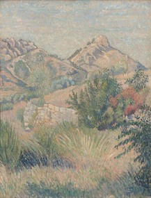
Painting, Lucien PISSARRO, Mt Tourris, Toulon, 1939
... Benalla Art Gallery Benalla Art Gallery Benalla Botanical Gardens Bridge Street Benalla high-country Impressionism Landscape Trees Mountains Pastoral Stone wall Europe Recto: Signed with a monogram in blue paint l.r.c of composition; Dated 1939; Not titled Rural landscape with stonewall, trees and mountains. ...Born: Paris, France 1836; Died: London, England 1944ImpressionismLedger Bequest, 1993Rural landscape with stonewall, trees and mountains. Cream, green, gold and blue wood moulding frame.Recto: Signed with a monogram in blue paint l.r.c of composition; Dated 1939; Not titledlandscape, trees, mountains, pastoral, stone wall, europe -
Winchelsea and District Historical Society
Photograph, Old wooden bridge and New Bluestone Bridge circa 1867
... Winchelsea and District Historical Society Old Shire Offices - Hesse Street Winchelsea great-ocean-road photograph taken circa 1867/8 Original wooden bridge built about 1857 Photo of Blue stone bridge, as is today This photo is important, shows Winchelsea before many buildings. ...photograph taken circa 1867/8 Original wooden bridge built about 1857Photo of Blue stone bridge, as is today This photo is important, shows Winchelsea before many buildings.Very early Winchelsea circa 1867/8.photo taken from opposite old Library. Early wooden bridge right foreground and present bluestone bridge centre foreground. First Shire Hall and Dr. Meyler,s residence right above wooden bridge. On the left is Stirling's StoreOld wooden Bridge and New Bluestone Bridge circa 1867. Winchelsea Shire Hall top right (First Shire Hall).bridge, dr. meyler, stirling's store, first shire hall, wooden. -
 Sunbury Family History and Heritage Society Inc.
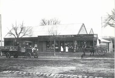
Photograph, Commercial Stores
... In 1866, Peter purchased the blue stone general store in Macedon Street near the bridge. He later built the Commercial Hotel also in Macedon Street and near the Ballcourt Hotel.Before the railway arrived in Sunbury, Macedon Street was Sunbury's main commercial centre. ...In 1866, Peter purchased the blue stone general store in Macedon Street near the bridge. He later built the Commercial Hotel also in Macedon Street and near the Ballcourt Hotel.Before the railway arrived in Sunbury, Macedon Street was Sunbury's main commercial centre. ...Commercial Stores was owned and run by Peter Eadie from Perthshire in Scotland, whose brothers were John and Robert. Peter and Robert arrived in Sunbury in 1864 to help their brother John with his milling enterprise. In 1866, Peter purchased the blue stone general store in Macedon Street near the bridge. He later built the Commercial Hotel also in Macedon Street and near the Ballcourt Hotel.Before the railway arrived in Sunbury, Macedon Street was Sunbury's main commercial centre. After the establishment of the railway, the commercial centre shifted close to the railway station. The Eadie family's stately home, 'Dunblane', was on the corner of Brook and Jackson Street.A Lutheran Church now occupies the lower section of the land fronting Brook Street, but the home has a local heritage listing. Peter Eadie became a Shire of Bulla councillor and President in 1880. Dunblane is from the Scots Gaelic -'dun' is a fortified hill and 'Blane' a missionary.The Eadie Family established one of Sunbury's general stores in the town and were involved in many other commercial activities.A print of a non-digital black and white photograph of a country general store. A medium sized vintage open tray truck is parked in front of the shop on the LHSand a horse-drawn open cart is on the RHS of the image.eadie family, peter eadie, commercial stores, macedon street, businesses -
 Bendigo Historical Society Inc.
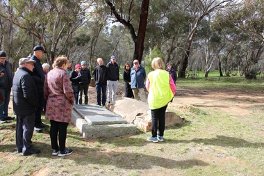
Bendigo Historical Society Walking Tour of Axedale, 1st Sept 2024
... bridge...campaspe...cobb and co stables axedale...blue stone...Places visited included the Protestant and Catholic Cemeteries, the "Blue Stone House", the 150-year-old bridge over the Axe Creek on the Sugerloaf Road, the old Cobb and Co Stables, St Andrews Church and the Campaspe River Bridge....It lies between Heathcote and Bendigo. axedale bendigo historical society walking tour st andrews church axedale axedale cemetery axe creek bridge campaspe cobb and co stables axedale blue stone house axedale Forty photos taken on the walking tour of Axedale by the Bendigo Historical Society. ...Axedale is a town in Victoria, Australia. It is located on the McIvor Highway, in the City of Greater Bendigo, east of Bendigo. It was surveyed and proclaimed in 1861. At the 2021 census, Axedale had a population of 984. The town is nestled alongside the Campaspe River which feeds out of Lake Eppalock. It has a golf course, tennis courts, a school, a pub and a convenience store/petrol station. It lies between Heathcote and Bendigo.Forty photos taken on the walking tour of Axedale by the Bendigo Historical Society. Places visited included the Protestant and Catholic Cemeteries, the "Blue Stone House", the 150-year-old bridge over the Axe Creek on the Sugerloaf Road, the old Cobb and Co Stables, St Andrews Church and the Campaspe River Bridge.axedale, bendigo historical society walking tour, st andrews church axedale, axedale cemetery, axe creek bridge, campaspe, cobb and co stables axedale, blue stone house axedale