Showing 68 items matching "bluestone road bridge"
-
 Sunbury Family History and Heritage Society Inc.
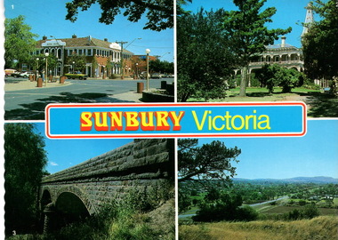
Postcard, Newcolourvue Productions Pty.Ltd, Sunbury Victoria, c1970s
... ...Bluestone Road Bridge...They are the 1930s Royal Hotel building which was build on the same site of the original building on the corner of Evans and Brook Streets, Rupertswood Mansion, built 1874-45, the historic bluestone road bridge over Jacksons Creek and a view of the township in the 1970s taken from Francis Boulevard....Royal Hotel Rupertswood Mansion Bluestone Road Bridge Sunbury Post cards Sunbury Victoria A coloured collection of four non-digital photographs of places in Sunbury in post card format. ...The four photographs on the post card are well-known places in the town. They are the 1930s Royal Hotel building which was build on the same site of the original building on the corner of Evans and Brook Streets, Rupertswood Mansion, built 1874-45, the historic bluestone road bridge over Jacksons Creek and a view of the township in the 1970s taken from Francis Boulevard.The four views of Sunbury give an overview of the township in the 1970s before the increased development took place from the 1980s onwards.A coloured collection of four non-digital photographs of places in Sunbury in post card format. The edges of the post card are rippled. The back of the card gives details of the places as well as the maker.Sunbury Victoriaroyal hotel, rupertswood mansion, bluestone road bridge, sunbury, post cards -
 Sunbury Family History and Heritage Society Inc.
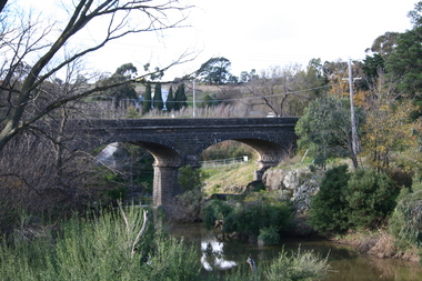
Photograph, Rosa McCall, 2011
... ...Bluestone Road Bridge...bluestone bridge spans the Jackson Creek on Macedon Street in Sunbury. It was built in 1860 and continued to carry traffic in and out of Sunbury until the early 1970s. The bend in the road...Until 1860 a punt was used to carry people and traffic across the Jackson Creek in Sunbury. Bridges Bluestone Road Bridge Macedon Street Bridge Pioneer Inn Powlett Street Jackson Street Goonawarra Vineyard A coloured photograph of a two-arched bluestone bridge spanning a waterway. ...The two-arched bluestone bridge spans the Jackson Creek on Macedon Street in Sunbury. It was built in 1860 and continued to carry traffic in and out of Sunbury until the early 1970s. The bend in the road on the approach to the east side was removed and a new bridge was built to carry the traffic. The old bridge became part of a pedestrian walk. The 'Pioneer Inn' was the first hotel to be built in Sunbury. It was on the west bank of the Jackson Creek near Powlett Street. Goonawarra is the building in the background.Until 1860 a punt was used to carry people and traffic across the Jackson Creek in Sunbury.A coloured photograph of a two-arched bluestone bridge spanning a waterway. Low growing trees and vegetation are growing along the river banks. A double-storey building is visible in the distance.bridges, bluestone road bridge, macedon street bridge, pioneer inn, powlett street, jackson street, goonawarra vineyard -
 Hume City Civic Collection
Photograph, 1970s
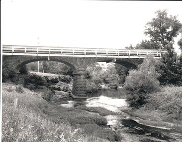
... A black and white photograph of the bluestone Macedon road bridge over the Jacksons Creek...Hume City Civic Collection 44 Macedon Street Sunbury melbourne The bluestone bridge which spans the Jacksons Creek was built in 1857 and replaced a laminated timber bridge. In the 1970s the stone bridge was replaced with a wider cement structure to accommodate the increased traffic flow. macedon street road bridge harris thomas lascelles jacksons creek george evans collection A black and white photograph of the bluestone Macedon road bridge over the Jacksons Creek Photograph ...The bluestone bridge which spans the Jacksons Creek was built in 1857 and replaced a laminated timber bridge. In the 1970s the stone bridge was replaced with a wider cement structure to accommodate the increased traffic flow.A black and white photograph of the bluestone Macedon road bridge over the Jacksons Creekmacedon street road bridge, harris, thomas lascelles, jacksons creek, george evans collection -
 Hume City Civic Collection
Photograph, 21/04/2005
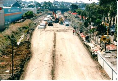
... The old railway lines have been removed and the bluestone road over rail bridge can be seen with excavation equipment in front of it. ...The upgrade took twelve months to complete and during this time bus services replaced the trains for commuters along Bendigo line. railways bendigo line railway stations bridges bluestone bridges sunbury railway station george evans collection A coloured photograph of the construction on the site of the Sunbury Railway Station. The old railway lines have been removed and the bluestone road ...This photograph was taken during the upgrade of the Bendigo Railway line at the Sunbury Station in 2005. The upgrade took twelve months to complete and during this time bus services replaced the trains for commuters along Bendigo line.A coloured photograph of the construction on the site of the Sunbury Railway Station. The old railway lines have been removed and the bluestone road over rail bridge can be seen with excavation equipment in front of it. Concrete sleepers which replaced the old sleepers are on the LHS of the photograph.railways, bendigo line, railway stations, bridges, bluestone bridges, sunbury railway station, george evans collection -
 Hume City Civic Collection
Photograph, Pre 1989
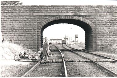
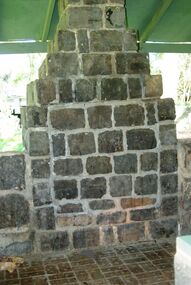
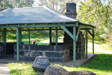
... The bluestone 'road over rail' bridge at Macedon Street is of state architectural, architectural, historical and engineering significance. ...Hume City Civic Collection 44 Macedon Street Sunbury melbourne The bluestone 'road over rail' bridge at Macedon Street is of state architectural, architectural, historical and engineering significance. ...The bluestone 'road over rail' bridge at Macedon Street is of state architectural, architectural, historical and engineering significance. It spans the first government regional railway. Its design and building was done according to strict English standards and made use of a bridge crossing instead of a level road crossing.A black and white photograph of a stone bridge with an eliptical arch spanning two rail tracks. A workman is standing between one set of tracks in the foreground and a railcart is next to the tracks. The station, footbridge and water tower are visible through the arch.road over rail bridge, bridges, sunbury railway station, water towers, pedestrian bridges, stone bridges, george evans collection -
 Eltham District Historical Society Inc
Photograph, Tess Justine (Nillumbik Shire Council), Murray's Bridge over the Diamond Creek, Eltham North, 19 Feb 2022
... Road was the third option, but the Commissioners' preferred option was No. 2 - on Murray's property. • The Railway Commissioners were not going to finance any such station and the works had to be funded by private landowners and residents, hence Murray investing in this himself. • Murray recommenced work two years later and finished his bridge in 1931 but unfortunately for him, the proposed flag station never eventuated. The bluestone...Road was the third option, but the Commissioners' preferred option was No. 2 - on Murray's property. • The Railway Commissioners were not going to finance any such station and the works had to be funded by private landowners and residents, hence Murray investing in this himself. • Murray recommenced work two years later and finished his bridge in 1931 but unfortunately for him, the proposed flag station never eventuated. The bluestone ...Murray's Bridge over the Diamond Creek on the Diamond Creek Trail just prior to demolition and replacement with a new steel bridge. Heritage advice obtained by Nillumbik Shire Council, following a suggestion by the Eltham District Historical Society (EDHS), is that the original bridge appears to have been a simplified version of the Country Roads Board’s (CRB) standard timber bridge design of the early-to-mid 1920s. In c1990 Murray’s bridge was renovated with three recycled steel girders as part of a bike/pedestrian path in the reserve. During these alterations many parts of the bridge were removed, and some were replaced. Heritage advice indicates the condition of Murray’s bridge is poor. The remaining original parts are all in poor condition, with severe weathering, splitting and rot, especially to the stringers retained on the bridge. Heritage advice is that Murray’s Bridge does not have sufficient significance in the cultural history of the Nillumbik area to warrant inclusion in the Nillumbik Shire Heritage Overlay and also does not have sufficient significance as a rare survivor to warrant inclusion in the Nillumbik Shire Heritage Overlay. There are no indications in the historical record that this site was individually important to the cultural history of this area. EDHS is comfortable with the heritage advice provided to Council and has worked closely on this project with Council. EDHS has suggested some of the removed timbers be used in the vicinity of the bridge for landscaping and possibly seating, so as to retain these remnants close to the site of the original bridge, which is the last old timber bridge along the lower reaches of the Diamond Creek. Mary (Sweeney) Murray and John Wright Murray selected 80 acres, Lot C Section 16 and Lot 5 Section 17 Parish of Nillumbik, under an occupation license in 1866. John died in 1867 and freehold was granted to his son John in 1873. The farm was known as ‘Laurel Hill’. John Junior was an Eltham Shire councillor and sometime president from 1887 up until 1897. He added Lot A Section 16 to the farm in ca1888. John and his younger brother James arranged to rent/purchase Lot B Section 17, across Diamond Creek to the west, in ca1900. It appears that John and James farmed separately for a few years, with a new homestead built for James ad family on the high point of Lot B Section 17 in ca1910. John sold off Lot 5 Section 17 in 1912. When John died in 1912 James took over the land on both sides of the Diamond Creek. The old homestead on the west side of the Creek disappeared. A farm bridge over Diamond Creek from this period may have been located close to the northern boundary of the farm. John Langlands, owner of the farm known as ‘Ihurst’ on the west side of Diamond Creek to the south of the Murray’s land, died in 1907. In 1909 his land was then subdivided into 100 lots to become the ‘Glen Park Estate’. Other similar subdivisions of nineteenth century farms around Eltham in this period included the ‘Franktonia (or Beard’s) Estate’ to the northeast and ‘Bonsack’s Estate’ between Eltham and Greensborough. Soon after the opening of the railway extension line from Eltham to Hurstbridge in 1912, Glen Park and nearby residents including James Murray agitated for a railway station or siding to be located half-way between Eltham and Hurstbridge, so that the Glen Park residents who used the railway daily did not have to walk into the Eltham or Hurstbridge stations. Some believed Coleman’s Corner (opposite Edendale Farm) was an appropriate spot for the platform. James Murray was among those who thought the railway should be located on his land, closer to half-way between Eltham and Hurstbridge stations. The Railways Commissioners warned that the locals would have to fund these works themselves. The Glen Park Estate residents initially had difficulty accessing Eltham by road, with only an old low-level bridge over Diamond Creek at the south end of their estate. A new timber trestle bridge across the creek, now on Wattletree Road, was opened in 1915. Road access to the north was gained in 1927 when the new Murray’s Road, which crossed the Murray’s land, was built. Residents continued to agitate for a Glen Park station. By 1926 the Railways Commissioners’ preferred site was on the Murray’s land. They arranged an estimate of cost of a full-length platform. The estimate was too much for the locals, who in 1928 argued unsuccessfully for a shorter and hence cheaper platform. By 1929 Murray had agreed to donate the land, but the locals would still have to fund the works. Murray decided, unilaterally it would appear, to commence work on a timber trestle road bridge over Diamond Creek to link the new Murray Road to the proposed station. Late in 1929 he stopped work on the bridge, for reasons unknown, but started work again and completed the bridge in 1931. There is no further newspaper evidence of the campaign for the Glen Park station until 1939, when Murray and another local, Mr Maxwell, met the Railways Commissioner. The Glen Park locale now included 45 homes on the west side of the creek and 20 on the Eltham side. Most of the residents used the train every day. The Commissioner remained adamant that only a full-length platform could be built for safety reasons. It appears the campaign dissolved at this point. The increasing move to cars may have had an impact. There is no evidence of Murray’s bridge ever being connected to Murray’s Road, or of it having wide use for any purpose by locals. James Murray died in 1947 and the farm was taken over by his son James (Jim). Jim started to sell off parts of the farm in the 1980s, retaining a few acres around the ca1910 homestead and building a new house there. Recreation reserves were established along the creek. In ca1990 Murray’s bridge was renovated with steel girders as part of a bike/pedestrian path in the reserve. The old farmhouse was demolished in ca2014. * * * A theory posted on local community Facebook groups was that the bridge was built in the 1860s and was built to be more robust than was necessary for the movement of cows from one side of the creek to the other. It was suggested the robustness was necessary to support the weight of gold ore being transferred from a mine on Murray’s land to a railway siding near Murrays Bridge (presumably for transfer and processing at Diamond Creek). Perhaps this may have been one of the motivators for Murray, who really knows? Knowing when mining operations ceased on his land and how that fits the overall timeline would be useful but at the time the bridge was built, local gold production was minimal at best. The known facts are: • The railway line came to Eltham in 1902. • The extension of the railway from Eltham to Hurstbridge was constructed in 1912 so no railway line even existed through Murray's property until 1912 and the Victorian Railways maps at the time show no such siding on Murray’s property. • In 1923 a new company was formed in anticipation of the old Diamond Creek Gold Mine being re-opened. The mine had been previously closed and flooded. It was noted in the press at the time that the mine was within a mile of the railway. Nothing really came of this. • Construction of Murrays Bridge was commenced by James Murray in early 1929 in anticipation of a proposed flag station being nominated on his land, but work ceased shortly afterwards. The proposed flag station was commonly referred to as Glen Park as the residents of the Glen Park Estate wanted Option 1, located near them with the platform adjacent to Colemans corner. This was probably never going to fly as it was virtually in eyesight of Eltham station. Allandale Road was the third option, but the Commissioners' preferred option was No. 2 - on Murray's property. • The Railway Commissioners were not going to finance any such station and the works had to be funded by private landowners and residents, hence Murray investing in this himself. • Murray recommenced work two years later and finished his bridge in 1931 but unfortunately for him, the proposed flag station never eventuated. The bluestone siding you reference may well have been built by Murray as part of the proposed station platform. • Up until then, apart from the Main Road bridge, which was washed away in 1924, virtually all local crossings over the Diamond Creek were low lying bridges – Kaylocks Bridge at Brougham Street, Diamond Street bridge, Glen Park Road bridge. It is expected that Murray also had a low-lying bridge to connect his land either side of the creek. These were all washed away or severely damaged multiple times in the 1920s. Lessons were learnt, and Murrays Bridge appears to have been built in accordance with Country Road Board standards of the time. Flood damage was ongoing, and even more recently constructed raised bridges kept getting washed away, e.g., the new Wattle Tree Road bridge in 1958 just months after completion. Murray’s bridge was reinforced with steel some 30 years ago presumably to provide additional floodwater resistance, given the history of bridges disappearing in floodwaters. • In March 1932 it was reported in the Advertiser that there were still some prospectors operating around Eltham North who apart from further scarring the face of the earth over the previous two years had gained significant experience but little gold - hardly a driving factor for constructing a dedicated railway siding and bridge to transfer gold ore. It is far more probable that James Murray was hoping to have the railway station located on his property and invested his money by building the bridge to lead to it as well as a station platform. Had the station eventuated, it may well have driven up the value of his land for subdivision and new housing estates like the Glen Park Estate. That did not eventuate. Whilst the bridge was indeed old (90 years), the core structure being completed in 1931, it had been modified substantially from original and hence had no significant historic value – i.e., it was not a representative example of its type, construction, and age. Given that the bridge was not worthy of saving, the Eltham District Historical Society with Council’s support, and the Eltham Woodworkers group endeavoured to see what suitable sized timbers were salvageable to fabricate a commemorative seat. Unfortunately, the experts at the Woodworkers group were unable to salvage any suitable length/width timbers to fabricate the seat due to the presence of rot. Last remaining wooden trestle bridge on the Diamond Creek Trail just prior to demolition and replacementBorn digital image (27)diamond creek (creek), diamond creek trail, murrays bridge, ‘laurel hill’, john wright murray, mary (sweeney) murra, john murray jnr, james murray, john langlands, ‘ihurst’, ‘glen park estate’, beard's estate, franktonia, bonsack's estate, glen park estate, glen park railway station -
 Greensborough Historical Society
Photograph, Main Street Greensborough, 1910c
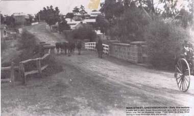
... Greensborough Historical Society 34A Glenauburn Road Lower Plenty Lower Plenty melbourne From caption: "Main Street Greensborough - Early [20th] century. a traffic jam in Main Street Greensborough, as a herd of horses are driven over the old bluestone bridge. ...From caption: "Main Street Greensborough - Early [20th] century. a traffic jam in Main Street Greensborough, as a herd of horses are driven over the old bluestone bridge. Photo taken by a lady driver waiting to cross the bridge, early this [20th] century".Black and white photograph, with description printed on lower right cornermain street greensborough, bluestone bridge -
![Photograph - Digital image, Bluestone bridge [Greensborough], 02/05/2013](/media/collectors/4f729f5697f83e03086015b8/items/57286ede2162f115acc6c06f/item-media/57286f112162f115acc6c886/item-fit-380x285.jpg?cb=6) Greensborough Historical Society
Greensborough Historical SocietyPhotograph - Digital image, Bluestone bridge [Greensborough], 02/05/2013
... Greensborough Historical Society 34A Glenauburn Road Lower Plenty Lower Plenty melbourne This photograph of the site of the Bluestone Bridge in Main Street Greensborough was taken in 2013 to show changes over 40 years, based on Ron Reynold’s sketches in the 1973 publication “Greensborough and Greenhills” published by Cypress Books. greensborough and greenhills ron reynolds main street greensborough bluestone bridge greensborough Digital copy of colour photograph. ...This photograph of the site of the Bluestone Bridge in Main Street Greensborough was taken in 2013 to show changes over 40 years, based on Ron Reynold’s sketches in the 1973 publication “Greensborough and Greenhills” published by Cypress Books.Digital copy of colour photograph.greensborough and greenhills, ron reynolds, main street greensborough, bluestone bridge greensborough -
 Greensborough Historical Society
Photograph - Digital Image, Pioneer Reserve 2014 -1, 21/05/2014
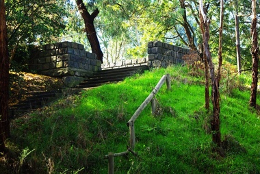
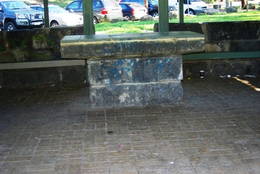
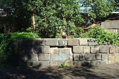
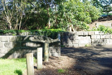
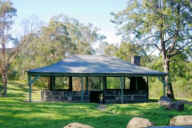
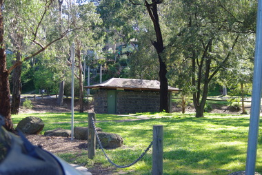
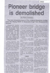
... Roads. It is adjacent to the site of Greensborough's first bridge across the Plenty River, c. 1864 - 1960s. The shelter, viewing platform, retaining wall and entrance are built from the bridge's massive bluestone arched abutments dismantled between 1974 and 1983. ...Roads. It is adjacent to the site of Greensborough's first bridge across the Plenty River, c. 1864 - 1960s. The shelter, viewing platform, retaining wall and entrance are built from the bridge's massive bluestone arched abutments dismantled between 1974 and 1983. ...Pioneer Reserve, Greensborough is a small park on the corner of St Helena and Diamond Creek Roads. It is adjacent to the site of Greensborough's first bridge across the Plenty River, c. 1864 - 1960s. The shelter, viewing platform, retaining wall and entrance are built from the bridge's massive bluestone arched abutments dismantled between 1974 and 1983. Pioneer Reserve is historically significant for its formative association with noted local landscape designer Gordon Ford in 1968, and it is likely that remnant large field stones at the entrance drive to the Reserve remain from his design. Photograph by Marilyn Smith 2014.Digital copy of colour photograph. -
 Greensborough Historical Society
Photograph - Digital Image, Pioneer Reserve 2014 -2, 01/10/2014
... Roads. It is adjacent to the site of Greensborough's first bridge across the Plenty River, c. 1864 - 1960s. The shelter, viewing platform, retaining wall and entrance are built from the bridge's massive bluestone arched abutments dismantled between 1974 and 1983. ...Roads. It is adjacent to the site of Greensborough's first bridge across the Plenty River, c. 1864 - 1960s. The shelter, viewing platform, retaining wall and entrance are built from the bridge's massive bluestone arched abutments dismantled between 1974 and 1983. ...Pioneer Reserve, Greensborough is a small park on the corner of St Helena and Diamond Creek Roads. It is adjacent to the site of Greensborough's first bridge across the Plenty River, c. 1864 - 1960s. The shelter, viewing platform, retaining wall and entrance are built from the bridge's massive bluestone arched abutments dismantled between 1974 and 1983. Photograph by Marilyn Smith 2014.Digital copy of colour photograph.pioneer reserve greensborough -
 Greensborough Historical Society
Photograph - Digital Image, Pioneer Reserve 2014 -3, 01/10/2014
... Roads. It is adjacent to the site of Greensborough's first bridge across the Plenty River, c. 1864 - 1960s. The shelter, viewing platform, retaining wall and entrance are built from the bridge's massive bluestone arched abutments dismantled between 1974 and 1983. ...Roads. It is adjacent to the site of Greensborough's first bridge across the Plenty River, c. 1864 - 1960s. The shelter, viewing platform, retaining wall and entrance are built from the bridge's massive bluestone arched abutments dismantled between 1974 and 1983. ...Pioneer Reserve, Greensborough is a small park on the corner of St Helena and Diamond Creek Roads. It is adjacent to the site of Greensborough's first bridge across the Plenty River, c. 1864 - 1960s. The shelter, viewing platform, retaining wall and entrance are built from the bridge's massive bluestone arched abutments dismantled between 1974 and 1983. Photograph by Marilyn Smith 2014.Digital copy of colour photograph.pioneer reserve greensborough -
 Greensborough Historical Society
Photograph - Digital Image, Pioneer Reserve 2014 -4, 23/09/2014
... Roads. It is adjacent to the site of Greensborough's first bridge across the Plenty River, c. 1864 - 1960s. The shelter, viewing platform, retaining wall and entrance are built from the bridge's massive bluestone arched abutments dismantled between 1974 and 1983. ...Roads. It is adjacent to the site of Greensborough's first bridge across the Plenty River, c. 1864 - 1960s. The shelter, viewing platform, retaining wall and entrance are built from the bridge's massive bluestone arched abutments dismantled between 1974 and 1983. ...Pioneer Reserve, Greensborough is a small park on the corner of St Helena and Diamond Creek Roads. It is adjacent to the site of Greensborough's first bridge across the Plenty River, c. 1864 - 1960s. The shelter, viewing platform, retaining wall and entrance are built from the bridge's massive bluestone arched abutments dismantled between 1974 and 1983. Photograph by Marilyn Smith 2014.Digital copy of colour photograph.pioneer reserve greensborough -
 Greensborough Historical Society
Photograph - Digital Image, Pioneer Reserve 2014 -5, 23/09/2014
... Roads. It is adjacent to the site of Greensborough's first bridge across the Plenty River, c. 1864 - 1960s. The shelter, viewing platform, retaining wall and entrance are built from the bridge's massive bluestone arched abutments dismantled between 1974 and 1983. ...Roads. It is adjacent to the site of Greensborough's first bridge across the Plenty River, c. 1864 - 1960s. The shelter, viewing platform, retaining wall and entrance are built from the bridge's massive bluestone arched abutments dismantled between 1974 and 1983. ...Pioneer Reserve, Greensborough is a small park on the corner of St Helena and Diamond Creek Roads. It is adjacent to the site of Greensborough's first bridge across the Plenty River, c. 1864 - 1960s. The shelter, viewing platform, retaining wall and entrance are built from the bridge's massive bluestone arched abutments dismantled between 1974 and 1983. Photograph by Marilyn Smith 2014.Digital copy of colour photograph.pioneer reserve greensborough -
 Greensborough Historical Society
Photograph - Digital Image, Pioneer Reserve 2014 -6, 23/09/2014
... Roads. It is adjacent to the site of Greensborough's first bridge across the Plenty River, c. 1864 - 1960s. The shelter, viewing platform, retaining wall and entrance are built from the bridge's massive bluestone arched abutments dismantled between 1974 and 1983. ...Roads. It is adjacent to the site of Greensborough's first bridge across the Plenty River, c. 1864 - 1960s. The shelter, viewing platform, retaining wall and entrance are built from the bridge's massive bluestone arched abutments dismantled between 1974 and 1983. ...Pioneer Reserve, Greensborough is a small park on the corner of St Helena and Diamond Creek Roads. It is adjacent to the site of Greensborough's first bridge across the Plenty River, c. 1864 - 1960s. The shelter, viewing platform, retaining wall and entrance are built from the bridge's massive bluestone arched abutments dismantled between 1974 and 1983. Photograph by Marilyn Smith 2014.Digital copy of colour photograph.pioneer reserve greensborough -
 Greensborough Historical Society
Photograph - Digital Image, Pioneer Reserve 2014, 23/09/2014
... Roads. It is adjacent to the site of Greensborough's first bridge across the Plenty River, c. 1864 - 1960s. The shelter, viewing platform, retaining wall and entrance are built from the bridge's massive bluestone arched abutments dismantled between 1974 and 1983. ...Roads. It is adjacent to the site of Greensborough's first bridge across the Plenty River, c. 1864 - 1960s. The shelter, viewing platform, retaining wall and entrance are built from the bridge's massive bluestone arched abutments dismantled between 1974 and 1983. ...Pioneer Reserve, Greensborough is a small park on the corner of St Helena and Diamond Creek Roads. It is adjacent to the site of Greensborough's first bridge across the Plenty River, c. 1864 - 1960s. The shelter, viewing platform, retaining wall and entrance are built from the bridge's massive bluestone arched abutments dismantled between 1974 and 1983. Photograph by Marilyn Smith 2014.Digital copy of colour photograph.pioneer reserve greensborough -
 Greensborough Historical Society
Photograph - Digital Image, Pioneer Reserve 2014 -8, 23/09/2014
... Roads. It is adjacent to the site of Greensborough's first bridge across the Plenty River, c. 1864 - 1960s. The shelter, viewing platform, retaining wall and entrance are built from the bridge's massive bluestone arched abutments dismantled between 1974 and 1983. ...Roads. It is adjacent to the site of Greensborough's first bridge across the Plenty River, c. 1864 - 1960s. The shelter, viewing platform, retaining wall and entrance are built from the bridge's massive bluestone arched abutments dismantled between 1974 and 1983. ...Pioneer Reserve, Greensborough is a small park on the corner of St Helena and Diamond Creek Roads. It is adjacent to the site of Greensborough's first bridge across the Plenty River, c. 1864 - 1960s. The shelter, viewing platform, retaining wall and entrance are built from the bridge's massive bluestone arched abutments dismantled between 1974 and 1983. Photograph by Marilyn Smith 2014.Digital copy of colour photograph.pioneer reserve greensborough -
 Greensborough Historical Society
Print, Greensborough 1889 / Arthur Elliott, 1889_
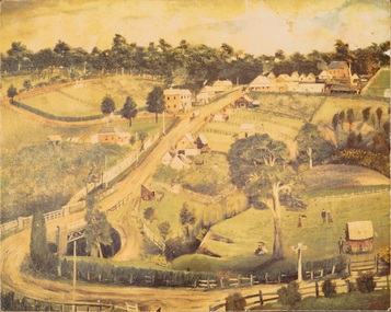
... Greensborough Historical Society 34A Glenauburn Road Lower Plenty Lower Plenty melbourne Mounted print of "Greensborough 1889 painted by Arthur Elliott". Shows Main Street Greensborough with the Methodist Church in upper right corner, Lower Park and bluestone bridge in foreground. ...Mounted print of "Greensborough 1889 painted by Arthur Elliott". Shows Main Street Greensborough with the Methodist Church in upper right corner, Lower Park and bluestone bridge in foreground.A view of rural Greensborough 1889.Print of painting, mounted on masonite.main street greensborough, arthur elliott -
 Greensborough Historical Society
Photograph - Digital image, Dennis Ward, Bridge Plaque - Pioneer Park Greensborough, 27/03/2010
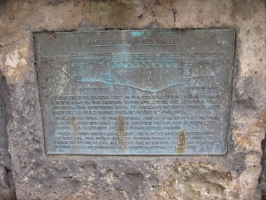
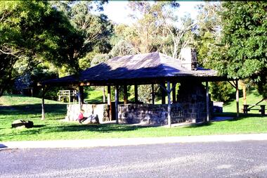
... Road Lower Plenty Lower Plenty melbourne Plaque at Pioneer Reserve Greensborough: "Shire of Diamond Valley. The bluestones used in the construction of this viewing platform and in the carpark entry structure and retaining wall are from the northern arch of Greensborough's first Plenty River Bridge built in the 1860s adjacent to this site. ...Plaque at Pioneer Reserve Greensborough: "Shire of Diamond Valley. The bluestones used in the construction of this viewing platform and in the carpark entry structure and retaining wall are from the northern arch of Greensborough's first Plenty River Bridge built in the 1860s adjacent to this site. The centre span of the original bridge was removed in 1865 when the western half of the existing bridge was constructed leaving the northern and southern stone arches. The southern arch was retained until floods in 1874 necessitated its removal. The picnic shelter in this reserve was constructed using stone from this abutment. The northern arch was removed in 1983 when widening of the existing bridge commenced."Digital copy of colour photograph.plenty river, pioneer reserve greensborough -
 Greensborough Historical Society
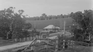
Photograph - Digital image, Main Street Bridge Greensborough, 1910c
... Road Lower Plenty Lower Plenty melbourne View of bridge over Plenty River at Greensborough. Photographs from the collection of Peter Blackbourn, a descendant of the Chapman Stock family. Annotations to photos by Peter Blackbourn. peter blackbourn main street greensborough bluestone ...View of bridge over Plenty River at Greensborough. Photographs from the collection of Peter Blackbourn, a descendant of the Chapman Stock family. Annotations to photos by Peter Blackbourn.Digital copy of black and white or sepia photograph.peter blackbourn, main street greensborough, bluestone bridge -
 Greensborough Historical Society
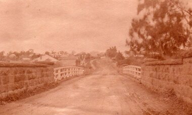
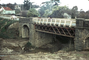
Newspaper clipping, Fiona Cameron, Pioneer bridge is demolished, by Fiona Cameron, 1974_
... Describes the removal of the bluestone bridge abutment on the north side of the Plenty River in Greensborough, to make way for the Diamond Creek Road bridge duplication....Greensborough Historical Society 34A Glenauburn Road Lower Plenty Lower Plenty melbourne Describes the removal of the bluestone bridge abutment on the north side of the Plenty River in Greensborough, to make way for the Diamond Creek Road bridge duplication. plenty river diamond creek road Photocopy of news article Pioneer bridge is demolished, by Fiona Cameron Newspaper clipping Fiona Cameron Diamond valley Leader ...Describes the removal of the bluestone bridge abutment on the north side of the Plenty River in Greensborough, to make way for the Diamond Creek Road bridge duplication.Photocopy of news articleplenty river, diamond creek road -
![Newspaper Clipping - Digital Image, End of Plenty Bridge 1968 [Bluestone Bridge Greensborough], 16/04/1968](/media/collectors/4f729f5697f83e03086015b8/items/5eb3aa9d21ea670b94feceb5/item-media/5eb3acc621ea670b9400fd28/item-fit-380x285.jpg?cb=6) Greensborough Historical Society
Greensborough Historical SocietyNewspaper Clipping - Digital Image, End of Plenty Bridge 1968 [Bluestone Bridge Greensborough], 16/04/1968
... Greensborough Historical Society 34A Glenauburn Road Lower Plenty Lower Plenty melbourne Removal of the bluestone bridge over the Plenty River in 1968. ...Removal of the bluestone bridge over the Plenty River in 1968. Photograph shows workmen removing the steel girders which covered the centre span. Pioneer Reserve is also mentioned.News clipping, black and white text and image.plenty river greensborough, bluestone bridge greensborough, pioneer reserve greensborough -
 Greensborough Historical Society
Slide - Photograph, John Ramsdale, Picnic shelter, Pioneer Reserve: Slide 22, 1990s
... Greensborough Historical Society 34A Glenauburn Road Lower Plenty Lower Plenty melbourne Photograph shows Pioneer Reserve picnic shelter in Greensborough. This shelter was built from bluestones from the old bridge over Plenty River. ...Photograph shows Pioneer Reserve picnic shelter in Greensborough. This shelter was built from bluestones from the old bridge over Plenty River.Part of the John Ramsdale collection of slides and audio visual material.Colour photograph scanned from slide.No maker's marks. No caption on slide.plenty river, bluestone bridge greensborough, pioneer reserve greensborough -
 Greensborough Historical Society
Slide - Photograph, John Ramsdale, Pioneer Reserve plaque: Slide 26, 1990s
... Greensborough Historical Society 34A Glenauburn Road Lower Plenty Lower Plenty melbourne Photograph shows the Pioneer Reserve Park Plaque explaining that the bluestones came from the bridge over the Plenty River at Greensborough. ...Photograph shows the Pioneer Reserve Park Plaque explaining that the bluestones came from the bridge over the Plenty River at Greensborough.Part of the John Ramsdale collection of slides and audio visual material.Colour photograph scanned from slide.No maker's marks. No caption on slide.plenty river, pioneer reserve greensborough, bluestone bridge greensborough -
![Article and Photograph, Greensborough [Rose Series postcards], 2017_](/media/collectors/4f729f5697f83e03086015b8/items/5dd4a93b21ea6715f012648b/item-media/5dd4a96421ea6715f01297a9/item-fit-380x285.jpg?cb=6) Greensborough Historical Society
Greensborough Historical SocietyArticle and Photograph, Greensborough [Rose Series postcards], 2017_
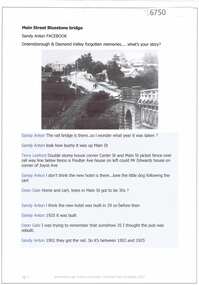
... Road Lower Plenty Lower Plenty melbourne Photos of Greensborough taken from the Rose Series of postcards, posted by Helen White. This photograph and text was copied from a Facebook site. Members are people who lived in the Greensborough area and share their reminiscences of the area with others. The site is administered by a GHS member but is not officially affiliated with the Society. Any information is the opinion of the contributor. greensborough bluestone bridge ...Photos of Greensborough taken from the Rose Series of postcards, posted by Helen White.This photograph and text was copied from a Facebook site. Members are people who lived in the Greensborough area and share their reminiscences of the area with others. The site is administered by a GHS member but is not officially affiliated with the Society. Any information is the opinion of the contributor. Article and photograph sourced from social media.greensborough, bluestone bridge greensborough, greensborough hotel -
 Greensborough Historical Society
Article and Photograph, Main Street Bluestone bridge, 2017_
... Greensborough Historical Society 34A Glenauburn Road Lower Plenty Lower Plenty melbourne Information and photos about the bluestone bridge over the Plenty River in Main Street Greensborough This photograph and text was copied from a Facebook site. ...Information and photos about the bluestone bridge over the Plenty River in Main Street GreensboroughThis photograph and text was copied from a Facebook site. Members are people who lived in the Greensborough area and share their reminiscences of the area with others. The site is administered by a GHS member but is not officially affiliated with the Society. Any information is the opinion of the contributor. Article and photograph sourced from social media.bluestone bridge greensborough, plenty river, main street greensborough -
 Greensborough Historical Society
Photograph - Digital Image, Greensborough Bluestone Bridge, circa 1960, 1960s
... Greensborough Historical Society 34A Glenauburn Road Lower Plenty Lower Plenty melbourne View of Greensborough bluestone bridge, circa 1960. ...View of Greensborough bluestone bridge, circa 1960. The bridge was demolished in 1974. Digital copy of colour photographbluestone bridge greensborough -
 Greensborough Historical Society
Photograph - Photograph (Framed), Greensborough bridge, 1870s
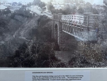
... Greensborough Historical Society 34A Glenauburn Road Lower Plenty Lower Plenty melbourne Greensborough bridge caption reads: "This fine old bluestone bridge was built in the 1860s to carry increasing traffic to the gold fields and farms to the north. ...Greensborough bridge caption reads: "This fine old bluestone bridge was built in the 1860s to carry increasing traffic to the gold fields and farms to the north. The stonemason was James Neave McKenzie. In more recent years this magnificent stone structure had to be replaced by a more modern bridge."From the John Davidson collection.Photograph in black plastic frame with typed caption on matte.john davidson, mckenzie bridge, greensborough, blue stone bridge -
 Greensborough Historical Society
Photograph - Digital Image, Plenty Bridge Hotel, Lower Plenty, 1870s
... Road Lower Plenty Lower Plenty melbourne Lower Plenty Hotel. This photograph shows the original Plenty Bridge hotel with Lower Plenty bridge in the foreground. The hotel was built c1858 and the bluestone ...Lower Plenty Hotel. This photograph shows the original Plenty Bridge hotel with Lower Plenty bridge in the foreground. The hotel was built c1858 and the bluestone bridge in the 1860s to replace the earlier toll bridge built in 1858.The close proximity of the hotel to the bridge is an indication of the importance of these river crossings in the mid 19th centuryDigital copy of black and white photographlower plenty, plenty river, plenty bridge hotel, lower plenty bridge, lower plenty hotel -
 Greensborough Historical Society
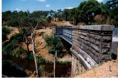
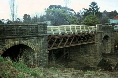
Photograph - Digital Image, Anne Paul, Opening of restored Old Lower Plenty Bridge 2001 - side view of bridge, 14/03/2001
... Road Lower Plenty Lower Plenty melbourne The opening of the restored Old Lower Plenty Bridge, opened on 14/03/2001 by the Minister for Environment and Conservation Sherryl Garbutt MLA and Mayor of Banyule Cr Dale Peters. The project was jointly funded by Banyule Council and Parks Victoria. The restored bridge is the oldest remaining bridge in the former Shire of Eltham and forms part of the Plenty River Trail. This photograph shows the bridge from the side elevation, showing the bluestone ...The opening of the restored Old Lower Plenty Bridge, opened on 14/03/2001 by the Minister for Environment and Conservation Sherryl Garbutt MLA and Mayor of Banyule Cr Dale Peters. The project was jointly funded by Banyule Council and Parks Victoria. The restored bridge is the oldest remaining bridge in the former Shire of Eltham and forms part of the Plenty River Trail. This photograph shows the bridge from the side elevation, showing the bluestone and iron construction.Digital copy of colour photographlower plenty, lower plenty bridge, sherryl garbutt, dale peters, banyule council, parks victoria -
 Greensborough Historical Society
Photograph - Photograph - Digital Image, Bluestone bridge Greensborough 1960s, 1960s
... Greensborough Historical Society 34A Glenauburn Road Lower Plenty Lower Plenty melbourne A photograph of the bluestone bridge over the Plenty River at Greensborough 1960s. bluestone bridge greensborough plenty river greensborough main street greensborough Digital copy of colour photograph. ...A photograph of the bluestone bridge over the Plenty River at Greensborough 1960s.Digital copy of colour photograph. Second photo is cropped copy.bluestone bridge greensborough, plenty river greensborough, main street greensborough