Showing 1222 items matching "boundaries"
-
 Kiewa Valley Historical Society
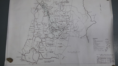
Map - Bogong High Plains - Grazing Runs, Grazing Run Boundaries 1960 - Soil Conservation Authority
... Grazing Run Boundaries 1960 - Soil Conservation Authority...The Soil Conservation Authority recorded each family's area boundaries which were updated in June 1972 and continued to be adjusted until cattle were banned in 2005. ...Names of families with grazing runs and the boundaries are shown....Names of families with grazing runs and the boundaries are shown. Grazing Run Boundaries 1960 - Soil Conservation Authority Map - Bogong High Plains - Grazing Runs ...Cattle grazing on the Bogong High Plains during summer commenced in the 1840s and continued for many years. The Soil Conservation Authority recorded each family's area boundaries which were updated in June 1972 and continued to be adjusted until cattle were banned in 2005. The tradition of cattle grazing continues to be controversial.Holders of grazing rights for grazing on the Bogong High Plains were allocated specific areas recorded by the Soil Conservation Authority in 1972. Cattle have been banned in the Alpine National Park due to their impact on the environment.White paper with brown print. Bogong High Plains from Feathertop in the west to Mt Nelse in the east showing physical boundaries including the Kiewa Hydro Electric Scheme, roads, rivers and mountains. Names of families with grazing runs and the boundaries are shown.cattlemen, grazing runs, bogong high plains, kiewa valley families -
 Federation University Historical Collection
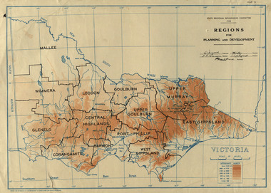
Map, Victoria: Regions for Planning and Development, 1944, 1944
... This map was produced for the State Regional Boundaries Committee ...State Regional Boundaries Committee...State Regional Boundaries Committee...Victoria: Regions for Planning and Development, 1944 Map Map State Regional Boundaries Committee Crown Lands and Survey State Regional Boundaries Committee Crown Lands and Survey ...This map was produced for the State Regional Boundaries Committee Two colour map of Victoria showing the regions for planning and development. The regions are Central Highlands, Mallee, Wimmera, Glenelg, Corangamite, Barwon, Loddon, Goulburn, Upper Goulburn, Upper Murray, East Gippsland, West Gippsland, Port Phillip.central highlands, mallee, wimmera, glenelg, corangamite, barwon, loddon, goulburn, upper goulburn, upper murray, east gippsland, west gippsland, port phillip, victoria, m4486 -
 Whitehorse Historical Society Inc.
Article, Box Hill keen to retain its existing boundaries, 1986
... Box Hill keen to retain its existing boundaries....Article about discussions over Box Hill and Nunawading boundaries....Box Hill keen to retain its existing boundaries. Article Article ...Article about discussions over Box Hill and Nunawading boundaries.Article about discussions over Box Hill and Nunawading boundaries.Article about discussions over Box Hill and Nunawading boundaries.local government, city of box hill, city of nunawading, amalgamations -
Victorian Aboriginal Corporation for Languages
Book, C C Culvenor, The boundaries of the Mount Franklin Aboriginal Reserve, 1992
... The boundaries of the Mount Franklin Aboriginal Reserve..."This enquiry into the boundaries of the Mount Franklin Aboriginal Reserve had its origins in the preparation of a biography of geologist Thomas Smith of Sandon, which raised queries about Boundary Gully Road, Parkers Gully and the location in that vicinity of the Reserve boundary. ...The boundaries of the Mount Franklin Aboriginal Reserve Book C C Culvenor ..."This enquiry into the boundaries of the Mount Franklin Aboriginal Reserve had its origins in the preparation of a biography of geologist Thomas Smith of Sandon, which raised queries about Boundary Gully Road, Parkers Gully and the location in that vicinity of the Reserve boundary. At a subsequent meeting of the Daylesford Historical Society, commemorating the 150th anniversary of the founding of the Aboriginal Reserve at Franklinford in 1841, it became clear that the actual boundaries were only poorly known ... A search for information srouces in Melbourne and Sydney did not produce an overall Plan, but it is hoped that the material obtained will present a sufficiently accurate picture to be useful to other local historians and be of some interest also to the general reader" --Preface. Contents: The boundaries of the Mt. Franklin Aboriginal Reserve The five mile radius The Tarrengower challenge Provisional boundaries Survey of the Reserve Breakup of the Reserve References Appendices.maps, b&w illustrations, b&w photographsmount franklin -
Whitehorse Historical Society Inc.
Article, Aboriginal tribal boundaries of Victoria, n.d
... Aboriginal tribal boundaries of Victoria...Map of Victoria showing tribal names and boundaries in Victoria with comment on activities of the Christian Action Committee....Aboriginal tribal boundaries of Victoria Article Article ...Map of Victoria showing tribal names and boundaries in Victoria with comment on activities of the Christian Action Committee.Map of Victoria showing tribal names and boundaries in Victoria with comment on activities of the Christian Action Committee.Map of Victoria showing tribal names and boundaries in Victoria with comment on activities of the Christian Action Committee.aborigines, christian action committee -
Whitehorse Historical Society Inc.
Document, Municipal boundaries, 2010
... Municipal boundaries...Talk given to Whitehorse Historical Society on changes to municipal boundaries in Victoria 1842-1995 on 13 February 2010....Municipal boundaries Document Document ...Talk given to Whitehorse Historical Society on changes to municipal boundaries in Victoria 1842-1995 on 13 February 2010.Talk given to Whitehorse Historical Society on changes to municipal boundaries in Victoria 1842-1995 on 13 February 2010.Talk given to Whitehorse Historical Society on changes to municipal boundaries in Victoria 1842-1995 on 13 February 2010.municipal boundaries, local government, cities and towns -
 Greensborough Historical Society
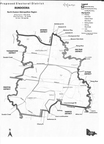
Map - Map (Copy), Electoral Boundaries Commission, Proposed electoral district: Bundoora, 01/07/2021
... Proposed revised electoral boundaries for the electoral district of Bundoora (North-Eastern Metropolitan Region) as at 01/07/2021...Electoral Boundaries Commission...Greensborough Historical Society 34A Glenauburn Road Lower Plenty Lower Plenty melbourne Proposed revised electoral boundaries for the electoral district of Bundoora (North-Eastern Metropolitan Region) as at 01/07/2021 electoral boundaries bundoora - maps victoria - parliament 1p. black and white copy of map Proposed electoral district: Bundoora Map Map (Copy) Electoral Boundaries Commission ...Proposed revised electoral boundaries for the electoral district of Bundoora (North-Eastern Metropolitan Region) as at 01/07/20211p. black and white copy of mapelectoral boundaries, bundoora - maps, victoria - parliament -
 Greensborough Historical Society
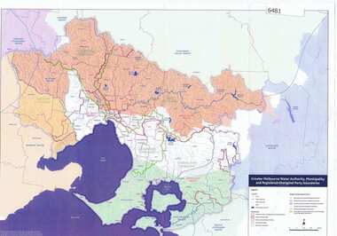
Maps, Greater Melbourne Water Authority, Municipality and Registered Aboriginal party Boundaries, 18/07/2018
... Greater Melbourne Water Authority, Municipality and Registered Aboriginal party Boundaries...Shows Melbourne Water and Municipal area boundaries, with boundaries of registered aboriginal parties, in central Victoria....Greensborough Historical Society 34A Glenauburn Road Lower Plenty Lower Plenty melbourne Shows Melbourne Water and Municipal area boundaries, with boundaries of registered aboriginal parties, in central Victoria. aborigines victoria water supply melbourne water Map reference 20180746 Printed in colour one side Greater Melbourne Water Authority, Municipality and Registered Aboriginal party Boundaries Maps Melbourne Water ...Shows Melbourne Water and Municipal area boundaries, with boundaries of registered aboriginal parties, in central Victoria.Printed in colour one sideMap reference 20180746aborigines victoria, water supply, melbourne water -
 Tarnagulla History Archive
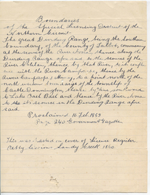
Handwritten statement: District boundaries, Boundaries, unknown
... Boundaries...A handwritten statement on lined paper relating to boundaries of the Special Licensing District of the Northern Circuit (court). ...Note on lower section states that the statement 'was pasted on cover of License Register Petty Sessions Sandy Creek 1860'. Boundaries Handwritten statement: District boundaries ...Murray Comrie Collection. A handwritten statement on lined paper relating to boundaries of the Special Licensing District of the Northern Circuit (court). Note on lower section states that the statement 'was pasted on cover of License Register Petty Sessions Sandy Creek 1860'.tarnagulla, court, petty sessions, licensing -
 Victorian Aboriginal Corporation for Languages
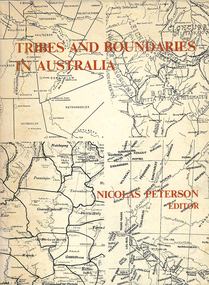
Book, Nicolas Peterson, Tribes and boundaries in Australia, 1976
... Tribes and boundaries in Australia...Some ecological bases for Australian tribal boundaries /? Norman B. Tindale Man and ecology in the highlands of southeastern Australia : a case study /? ...Milliken. Tribes and boundaries in Australia Book Nicolas Peterson ...Some ecological bases for Australian tribal boundaries /? Norman B. Tindale Man and ecology in the highlands of southeastern Australia : a case study /? Josephine Flood The natural and cultural areas of Aboriginal Australia : a preliminary analysis of population groupings with adaptive significance /? Nicolas Peterson 'The chain of connection' : the material evidence /? D.J. Mulvaney Realities and transformations : the tribes of the Western Desert of Australia /? Joseph B. Birdsell Structure, event and ecology in Aboriginal Australia : a comparative viewpoint /? Aram A. Yengoyan Territoriality and the problem of demarcating sociocultural space /? Ronald M. Berndt Communication and change in mythology /? Kenneth Maddock Levels of organisation and communication in Aboriginal Australia /? D.H. Turner Boundaries and kinship systems in Aboriginal Australia /? F.G.G. Rose Tribes, languages and other boundaries in northeast Queensland /? R.M.W. Dixon Aboriginal language distribution in the Northern Territory /? E.P. Milliken.maps, b&w photographs, diagramsecology, environment, sociology, kinship systems, language distribution -
 Victorian Aboriginal Corporation for Languages
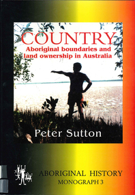
Book, Peter Sutton, Country : Aboriginal boundaries and land ownership in Australia, 1995
... Country : Aboriginal boundaries and land ownership in Australia...Critique of Davis and Prescott Aboriginal frontiers and boundaries in Australia and map, Davis, S. Australias extant and imputed traditional Aboriginal territories; uses anthropological and linguistic evidence to expose inaccuracies and lacunae in book and map; appended are comments on the Davis map by regional specialists....Victorian Aboriginal Corporation for Languages 33 Saxon Street Brunswick melbourne indigenous land boundaries Maps, colour photographs Critique of Davis and Prescott Aboriginal frontiers and boundaries in Australia and map, Davis, S. ...Critique of Davis and Prescott Aboriginal frontiers and boundaries in Australia and map, Davis, S. Australias extant and imputed traditional Aboriginal territories; uses anthropological and linguistic evidence to expose inaccuracies and lacunae in book and map; appended are comments on the Davis map by regional specialists.Maps, colour photographsindigenous land boundaries -
 Eltham District Historical Society Inc
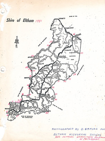
Map, Shire of Eltham (boundaries), 1991
... Shire of Eltham (boundaries)...Key to a collection of 35 photos taken by Doug Orford at 35 specific locations along the exact boundary of the then Shire of Eltham....Eltham District Historical Society Inc 728 Main Rd Eltham melbourne Key to a collection of 35 photos taken by Doug Orford at 35 specific locations along the exact boundary of the then Shire of Eltham. Shire of Eltham (boundaries) Map Map Doug Orford ...Key to a collection of 35 photos taken by Doug Orford at 35 specific locations along the exact boundary of the then Shire of Eltham. -
 Greensborough Historical Society
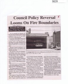
Newspaper - Newspaper Clipping, Banyule Observer, Council Policy Reversal Looms On Fire Boundaries, 03/02/2001
... Council Policy Reversal Looms On Fire Boundaries...At its meeting on January 29, Banyule City Council voted to defer a planned review of CFA and MFB boundaries within Banyule....Council Policy Reversal Looms On Fire Boundaries Newspaper Newspaper Clipping Banyule Observer ...At its meeting on January 29, Banyule City Council voted to defer a planned review of CFA and MFB boundaries within Banyule.Newspaper clipping with black text and black and white photo.banyule city council, cfa, mfb, country fire authority, metropolitan fire brigade -
 Bacchus Marsh & District Historical Society
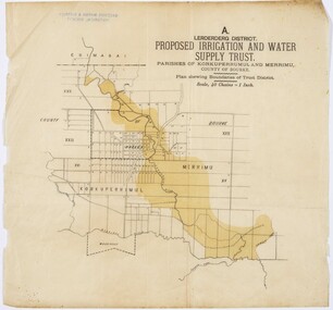
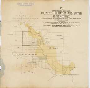
Map, Lerderderg District Proposed Irrigation and Water Supply Trust (A). Plan showing boundaries of Trust District
... Lerderderg District Proposed Irrigation and Water Supply Trust (A). Plan showing boundaries of Trust District....Printed paper map of the proposed Lerderderg District Irrigation and Water Supply. Plan showing boundaries of Trust District. The Lerderderg District lies within the Parishes of Korkuperrumul and Merrimu in the County of Bourke. ...Lerderderg District Proposed Irrigation and Water Supply Trust (A). Plan showing boundaries of Trust District. Map ...The 1886 Irrigation Act in Victoria introduced the first legislation in Australia designed to enable the creation of a detailed scheme for agricultural irrigation. Part of the legislation saw the use of government funds for local irrigation projects. These local projects were managed by local irrigation trusts. The Lerderderg Irrigation and Water Supply Trust] was formed in 1890. This map depicts the proposed area of the Trust.Printed paper map of the proposed Lerderderg District Irrigation and Water Supply. Plan showing boundaries of Trust District. The Lerderderg District lies within the Parishes of Korkuperrumul and Merrimu in the County of Bourke. At the top of the map above its title is the letter 'A; in capital lettering. Scale: 40 Chains = 1 inch.irrigation, water supply, lerderderg irrigation and water supply trust -
 University of Melbourne, Burnley Campus Archives
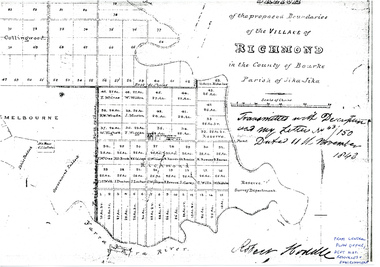
Plan - Photocopy, Sketch of the Proposed Boundaries of the Village of Richmond, 1843
... Sketch of the Proposed Boundaries of the Village of Richmond...Sketch of the proposed boundaries of the village of Richmond in the County of Bourke Parish of Jika-Jika. ...Resources & Environment Sketch of the proposed boundaries of the village of Richmond in the County of Bourke Parish of Jika-Jika. ...Sketch of the proposed boundaries of the village of Richmond in the County of Bourke Parish of Jika-Jika. Handwritten on original: "Transmitted with Description and my letter No 43/150 Dated 11th November 1843 Robert Hoddle." Shows Burnley Gardens site as "Reserve. Survey Department." original in Central Plan Office, Department of Natural Resources and EnvironmentIn ink: From Central Plan Office Dept. Nat. Resources & Environmentrichmond, jika-jika, survey department, yarra river, robert hoddle -
 Bacchus Marsh & District Historical Society
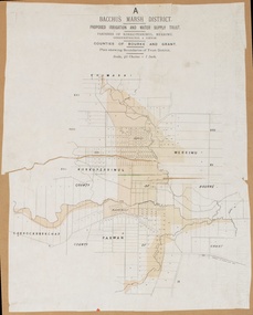
Map, Bacchus Marsh District (A). Proposed Irrigation and Water Supply Trust. Plan shewing boundaries of Trust District
... Proposed Irrigation and Water Supply Trust. Plan shewing boundaries of Trust District....Circa 1889. Plan showing boundaries of Trust District. The District lies within the Parishes of Korkuperrimul, Merrimu, Parwan and Gorrockburkchap in the Counties of Bourke and Grant. ...Proposed Irrigation and Water Supply Trust. Plan shewing boundaries of Trust District. Map ...The 1886 Irrigation Act in Victoria introduced the first legislation in Australia designed to enable the creation of a detailed scheme for agricultural irrigation. Part of the legislation saw the use of government funds for local irrigation projects. These local projects were managed by local irrigation trusts. The Bacchus Marsh Irrigation and Water Supply Trust was formed in 1889. This map depicts the proposed area of the Trust.Printed paper map of the proposed Bacchus Marsh Irrigation and Water Supply district. Circa 1889. Plan showing boundaries of Trust District. The District lies within the Parishes of Korkuperrimul, Merrimu, Parwan and Gorrockburkchap in the Counties of Bourke and Grant. At the top of the map above its title is the letter 'A; in capital lettering. Scale: 40 Chains = 1 inch.irrigation, water supply, bacchus marsh irrigation and water supply trust -
 Bacchus Marsh & District Historical Society
Map, Lerderderg District Proposed Irrigation and Water Supply Trust (C). Plan showing overlap in boundaries of the Trust District
... Plan showing overlap in boundaries of the Trust District...Plan showing overlap in boundaries of Trust District referred to in Mr Burke's report. ...Plan showing overlap in boundaries of the Trust District Map ...The 1886 Irrigation Act in Victoria introduced the first legislation in Australia designed to enable the creation of a detailed scheme for agricultural irrigation. Part of the legislation saw the use of government funds for local irrigation projects. These local projects were managed by local irrigation trusts. The Lerderderg Irrigation and Water Supply Trust was formed in 1890. Printed paper map of the proposed Lerderderg District Irrigation and Water Supply. Plan showing overlap in boundaries of Trust District referred to in Mr Burke's report. The Lerderderg District lies within the Parishes of Korkuperrumul and Merrimu in the County of Bourke. At the top of the map above its title is the letter 'C; in capital lettering. A note on this map states: 'Portion of Bacchus MarshUrban District included in area of proposed Trust District shown by hatched shaded lines thus /////////////irrigation, water supply, lerderderg irrigation and water supply trust -
University of Melbourne, Burnley Campus Archives
Book - Report, E.B. Littlejohn, Victoria 1944 State Regional Boundaries Committee Report on Regional Boundaries, 1944
... Victoria 1944 State Regional Boundaries Committee Report on Regional Boundaries...Maps 31 and 32 are composite sheets showing coverage of Victoria by various series of maps, and smaller versions of large maps Victoria 1944 State Regional Boundaries Committee Report on Regional Boundaries Book Report E.B. ...See paper catalogue for complete contents. Item formerly property of E.B. LittlejohnReport includes 32 maps of Regions for Planning and Development, geographical, weather, power, water resources, crops, livestock, etc. Maps 31 and 32 are composite sheets showing coverage of Victoria by various series of maps, and smaller versions of large mapse.b. littlejohn, planning, development, regions -
 Sunshine and District Historical Society Incorporated
Map - City of Sunshine Boundaries 1994 Maps
... 4 maps (wall) depicting the City of Sunshine Boundaries...City of Sunshine Boundaries 1991 wall maps...City of Sunshine City of Sunshine Boundaries 1991 wall maps 4 maps (wall) depicting the City of Sunshine Boundaries Map City of Sunshine Boundaries 1994 Maps ...City of Sunshine Boundaries 1991 wall mapscity of sunshine -
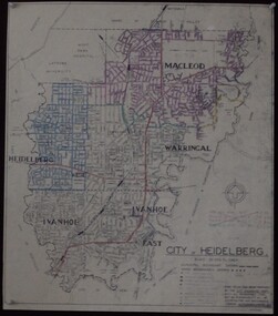
 Greensborough Historical Society
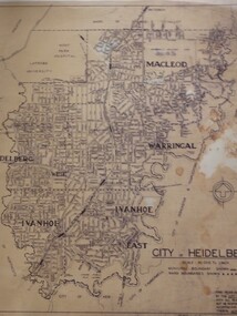
Map, City of Heidelberg: Municipal and Ward boundaries, 1967c
... City of Heidelberg: Municipal and Ward boundaries...Scale: 20 chs to 1 inch City of Heidelberg: Municipal and Ward boundaries Map City of Heidelberg ...This map of the City of Heidelberg was issued subsequent to the separation of Heidelberg's North Ward to become the Shire of Diamond ValleyBlack on waxed paper. Scale: 20 chs to 1 inchG M Hutchins. 50c.city of heidelberg, heidelberg -
 Ringwood and District Historical Society
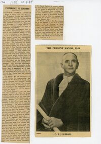
Newspaper, Extract reprinted from Ringwood Mail 20 April 1944 discussing boundaries of being "Ringwood" soldiers
... Extract reprinted from Ringwood Mail 20 April 1944 discussing boundaries of being "Ringwood" soldiers...Ringwood and District Historical Society 125A Warrandyte Road Ringwood North melbourne Also photo of Cr BJ Hubbard, Mayor of Ringwood in 1949 Extract reprinted from Ringwood Mail 20 April 1944 discussing boundaries of being "Ringwood" soldiers Newspaper ...Also photo of Cr BJ Hubbard, Mayor of Ringwood in 1949 -
 Ararat Gallery TAMA
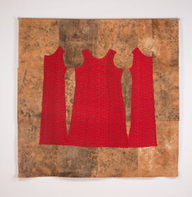
Mixed media, Nalda Searles, Inland Boundaries, 1997-2007
... Inland Boundaries...Ararat Gallery TAMA 82 Vincent Street Ararat grampians Inland Boundaries Mixed media Nalda Searles ... -
Victorian Aboriginal Corporation for Languages
Conference proceedings, Mary Jane Norris, Endangered languages beyond boundaries : community connections, collaborative approaches and cross-disciplinary research =? Langues en pe?ril au-dela? des frontie?res : connexions communautaires, approches collaboratives, et rechecrche interdisciplinaire : proceedings of the 17th FEL Conference Carleton University, Ottawa, Ontario Canada 1-4 October 2013, 2013
... Endangered languages beyond boundaries : community connections, collaborative approaches and cross-disciplinary research =? ...Victorian Aboriginal Corporation for Languages 33 Saxon Street Brunswick melbourne collaboration community involvement cross disciplinary research maps, b&w photographs, colour photographs, illustrations, graphs Session 1: Collaborations with language and cultural organizations, and governments Session 2: Collaborations with universities, researchers, institutes and schools Session 3: Strategies/issues across language, culture, geography, place and generations I: standardization and dialects Session 4: Strategies issues across language, culture, geography, place and generations II: Minority languages, regions and rural/urban areas Session 6: Language and culture connections: Health, well-being, and educational outcomes Session 7: Strategies/issues across language, culture, geography, place and generations III: Generations and families Session 8: Language assessment, documentation and diversity: Indicators of vitality, endangerment and the implications of data collection Session 5: Poster sessions I: Hard copy: Community connections, collaborative approaches, cross-disciplinary research Session 5: Poster session II: Electronic: Collaborative approaches with information and computer technologies Endangered languages beyond boundaries : community connections, collaborative approaches and cross-disciplinary research =? ...Session 1: Collaborations with language and cultural organizations, and governments Session 2: Collaborations with universities, researchers, institutes and schools Session 3: Strategies/issues across language, culture, geography, place and generations I: standardization and dialects Session 4: Strategies issues across language, culture, geography, place and generations II: Minority languages, regions and rural/urban areas Session 6: Language and culture connections: Health, well-being, and educational outcomes Session 7: Strategies/issues across language, culture, geography, place and generations III: Generations and families Session 8: Language assessment, documentation and diversity: Indicators of vitality, endangerment and the implications of data collection Session 5: Poster sessions I: Hard copy: Community connections, collaborative approaches, cross-disciplinary research Session 5: Poster session II: Electronic: Collaborative approaches with information and computer technologiesmaps, b&w photographs, colour photographs, illustrations, graphscollaboration, community involvement, cross disciplinary research -
Stawell Historical Society Inc
Map, Stawell Gold Mine, Tenement Boundaries Stawell Township 2001, August 2001
... Tenement Boundaries Stawell Township 2001...Stawell Historical Society Inc 46 Longfield St Stawell grampians mining gold Stawell Gold Mines Victoria Scale 1 : 20000 Showing Underground Development Tenement Boundaries Stawell Township 2001 Map Stawell Gold Mine ...Showing Underground Development Stawell Gold Mines Victoria Scale 1 : 20000mining, gold -
 University of Melbourne, Burnley Campus Archives
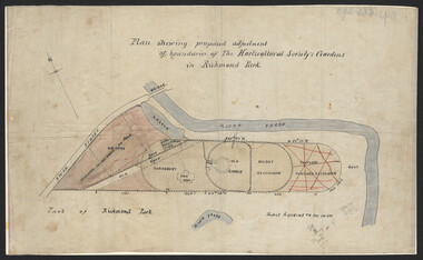
Plan, John S. Jenkins, Plan shewing proposed adjustment of boundaries of the Horticultural Society's Gardens in Richmond Park, c.1880-1884
... Plan shewing proposed adjustment of boundaries of the Horticultural Society's Gardens in Richmond Park...Plan shewing proposed adjustment of boundaries of the Horticultural Society's Gardens in Richmond Park Plan John S. ...Plan on linen fibre cloth. Shows layout of Burnley bound by Swan St., Yarra River and part of Richmond Park, coloured areas showing proposed area to be added to Park, the old road, shrubbery, new hall, old garden, recent extension and proposed further extension (crossed out in red ink). Scale 4 chains:1 inch. Probably drawn by John S. Jenkins, Town Surveyor, Richmond. Has been photographed so that additional copies can be made. On a CD plus 3 negatives, plus small coloured print. (Also copy glazed and framed for Centenary Exhibition - B92.0540.)john s. jenkins, gardens, richmond, horticultural society of victoria -
University of Melbourne, Burnley Campus Archives
Plan, Plan showing proposed adjustment of boundaries of the Horticultural Society's Gardens in Richmond Park, c.1880-1884
... Plan showing proposed adjustment of boundaries of the Horticultural Society's Gardens in Richmond Park...Plan showing proposed adjustment of boundaries of the Horticultural Society's Gardens in Richmond Park Plan ...Copy of B92.0535 framed and glazed.Some calculations added in pencilgardens, richmond, hoticultural society of victoria, river yarra, richmond park -
 City of Moorabbin Historical Society (Operating the Box Cottage Museum)
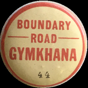
Badge - Boundary Road - Gymkhana, ca. 1929
... The Murrumbeena Branch of the Alfred Hospital Auxiliary held a grand charity gymkhana on 7 September, 1929 at the Central Speedway, Boundary Road, Bentleigh. It was a full racing program with several trotting events. ...Boundary Road - GYMKHANA - 44...Early settler market gardeners were generous with their support for local hospitals and charitable associations alfred hospital auxillary murrumbeena boundary road bentleigh central speedway pioneers moorabbin Boundary Road - GYMKHANA - 44 Metal Pin Badge Boundary Road - Gymkhana ...The Murrumbeena Branch of the Alfred Hospital Auxiliary held a grand charity gymkhana on 7 September, 1929 at the Central Speedway, Boundary Road, Bentleigh. It was a full racing program with several trotting events. There were also games and several well-stocked stalls. Early settler market gardeners were generous with their support for local hospitals and charitable associationsMetal Pin Boundary Road - GYMKHANA - 44alfred hospital auxillary, murrumbeena, boundary road, bentleigh, central speedway, pioneers, moorabbin -
 Emerald Museum & Nobelius Heritage Park
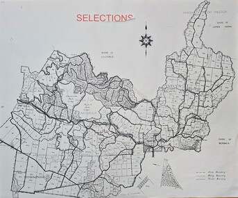
Map - Selections Map of Emerald and surrounding district, Unknown
... Selections/Shire Boundary/Riding Boundary/Parish Boundary...Emerald Museum & Nobelius Heritage Park 5 Crichton Rd Emerald yarra-valley-and-the-dandenong-ranges Selections/Shire Boundary/Riding Boundary/Parish Boundary Image of map of 'Selections' in Emerald and surrounding area Selections Map of Emerald and surrounding district Map Selections Map of Emerald and surrounding district ...Image of map of 'Selections' in Emerald and surrounding areaSelections/Shire Boundary/Riding Boundary/Parish Boundary -
Whitehorse Historical Society Inc.
Document, Healesville Freeway Reservation Renewal Project, 2012
... Supplementary documentation of boundaries, project purpose, and current land use....Agenda of meeting between VicRoads and Whitehorse Historical Society 1 Feb 2012, with supplementary documentation of boundaries, project purpose, and current land use...Whitehorse Historical Society Inc. 2-10 Deep Creek Road Mitcham melbourne Supplementary documentation of boundaries, project purpose, and current land use. ...Agenda of meeting between VicRoads and Whitehorse Historical Society 1 Feb 2012.Agenda of meeting between VicRoads and Whitehorse Historical Society 1 Feb 2012, with supplementary documentation of boundaries, project purpose, and current land useAgenda of meeting between VicRoads and Whitehorse Historical Society 1 Feb 2012.forest hill, vermont, vermont south, healesville freeway reservation, vicroads -
 Greensborough Historical Society
Maps, City of Heidelberg 1974, 1974c
... City of Heidelberg showing Municipal and Ward boundaries, prepared by City Engineers Department. ...Blueprint, 2 copies, one with some roads hand coloured, showing municipal and ward boundaries. Scale: 20 chains to 1 inch...Greensborough Historical Society 34A Glenauburn Road Lower Plenty Lower Plenty melbourne City of Heidelberg showing Municipal and Ward boundaries, prepared by City Engineers Department. ...City of Heidelberg showing Municipal and Ward boundaries, prepared by City Engineers Department. Made for Council use; copies available for sale to the public.Blueprint, 2 copies, one with some roads hand coloured, showing municipal and ward boundaries. Scale: 20 chains to 1 inchG. M. Hutchins. Authorised charge 50c.city of heidelberg, heidelberg