Showing 1175 items matching "boundary"
-
 Lakes Entrance Historical Society
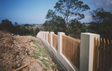
Photograph - Garden Cemetery Lakes Entrance Victoria, Lakes Post Newspaper, Western boundary of Garden Cemetery Lakes Entrance Victoria, 2003
... Western boundary of Garden Cemetery Lakes Entrance Victoria...Colour photograph of new boundary fence at Western boundary of Garden Cemetery Lakes Entrance Victoria. ...Lakes Entrance Historical Society 4 Marine Parade Lakes Entrance gippsland Genealogy Cemeteries Topography Colour photograph of new boundary fence at Western boundary of Garden Cemetery Lakes Entrance Victoria. ...Colour photograph of new boundary fence at Western boundary of Garden Cemetery Lakes Entrance Victoria. Also a second photograph of fence from a different anglegenealogy, cemeteries, topography -
 Flagstaff Hill Maritime Museum and Village
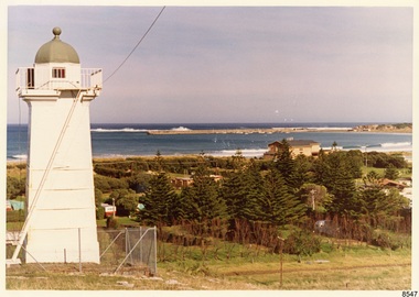
Photograph - Historical, Flagstaff Hill, John Lindsay, View of the Bay from the south boundary of the Ports and Harbours land, 1970s
... View of the Bay from the south boundary of the Ports and Harbours land...Label on the back: "VIEW OF THE BAY FROM the southern boundary of the Ports and Harbours land. No development below this area is likely to obstruct the view, due to the steep grade down to the Southern boundary of Flagstaff Hill property." ...View of the Bay from the south boundary of the Ports and Harbours land Photograph Historical, Flagstaff Hill John Lindsay ...The photograph shows the view of the shore and Lady Bay with the Breakwater and Middle Island all visible. It was taken to show that the Flagstaff Hill area was unlikely to have any further development between it and the Bay, with the view of development of the Flagstaff Hill Maritime Museum and Village. This photograph, a print, is one of a set of five that show the site of Flagstaff Hill. The photographer was John Lindsay, Founding Director of Flagstaff Hill Maritime Museum and Village, with the words "Photo J Lindsay" on the back. It was taken in the early 1970s during the initial stages of the development of Flagstaff Hill as a Museum and Maritime Village. The photographs belonged to the donor's grandparents, who lived in the Warrnambool district of Allansford/Naringal. The photograph is a record of the site and surrounds of Flagstaff Hill Maritime Museum and Village before its development and opening in 1975. It shows the Surfside Holiday Park, Surf Lifesaving Club, and the Breakwater. The photograph is significant for recording the location and condition of the Lower Lighthouse on the Hill.Coloured photograph, glassy print, one of a set of five. Flagstaff Hill's Lower Lighthouse is in the foreground above the Surfside Holiday Park. To the right of centre is the Surf Lifesaving Club. In the background is Lady Bay and the Breakwater and Middle Island, with the Southern Ocean the other side. The photograph's paper has the printer's watermark and a pencilled inscription on the back. The early 1970s scene was photographed by John Lindsay, Warrnambool.Label on the back: "VIEW OF THE BAY FROM the southern boundary of the Ports and Harbours land. No development below this area is likely to obstruct the view, due to the steep grade down to the Southern boundary of Flagstaff Hill property." Handwritten in pencil: "Photo J Lindsay"flagstaff hill, flagstaff hill maritime museum and village, warrnambool, maritime museum, maritime village, great ocean road, shipwreck coast, 1970s, photograph, surfside holiday park, lady bay, flagstaff hill site, john lindsay, lower lighthouse, lower light, surf lifesaving club, breakwater, middle island, ports and harbours -
 Whitehorse Historical Society Inc.
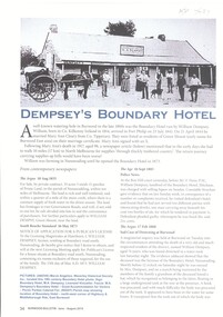
Article, Dempsey's Boundary Hotel, 1873
... Dempsey's Boundary Hotel...An article about Dempsey's Boundary Hotel, NW. cnr Highbury & Middleborough Roads, East Burwood. ...Dempsey William Boundary Hotel Green Mount Dempsey Mary Anne Parish of Nunawading An article about Dempsey's Boundary Hotel, NW. cnr Highbury & Middleborough Roads, East Burwood. ...An article about Dempsey's Boundary Hotel, NW. cnr Highbury & Middleborough Roads, East Burwood.An article about Dempsey's Boundary Hotel, NW. cnr Highbury & Middleborough Roads, East Burwood. Licensees Mary Anne & William Dempsey.An article about Dempsey's Boundary Hotel, NW. cnr Highbury & Middleborough Roads, East Burwood. dempsey william, boundary hotel, green mount, dempsey mary anne, parish of nunawading -
 Port Melbourne Historical & Preservation Society
Document - Electoral Roll, City of Port Melbourne, City of Port Melbourne, Voters Roll, City of Port Melbourne - Boundary Ward, Jul 1990
... Voters Roll, City of Port Melbourne - Boundary Ward...Voters roll, City of Port Melbourne 1990: List in alphabetical order of residents in Boundary Ward. Signature of A.D. Graham, Municipal Clerk, is on back page...Port Melbourne Historical & Preservation Society Port Melbourne Town Hall 333 Bay Street Port Melbourne melbourne Prepared by the Town Clerk's office. local government - city of port melbourne town clerks david graham Voters roll, City of Port Melbourne 1990: List in alphabetical order of residents in Boundary Ward. Signature of A.D. Graham, Municipal Clerk, is on back page Voters Roll, City of Port Melbourne - Boundary Ward Document Electoral Roll, City of Port Melbourne City of Port Melbourne ...Prepared by the Town Clerk's office. Voters roll, City of Port Melbourne 1990: List in alphabetical order of residents in Boundary Ward. Signature of A.D. Graham, Municipal Clerk, is on back pagelocal government - city of port melbourne, town clerks, david graham -
 Ringwood and District Historical Society
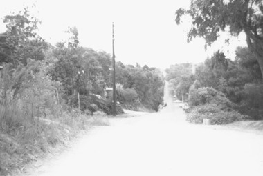
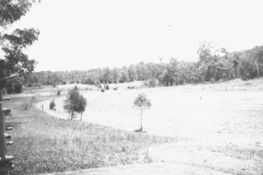
Photograph, Glenvale Road, North Ringwood - a boundary looking south. 1979
... Glenvale Road, North Ringwood - a boundary looking south. 1979...Glenvale Road - a boundary looking south from top of same hill (near Kubla Rd?)....Glenvale Road - a boundary looking south from top of same hill (near Kubla Rd?). ...[Kubis Dve or Kubba Rd?.]Written on back of photograph, "Jan. 79. Glenvale Road - a boundary looking south from top of same hill (near Kubla Rd?).More homes south than north." -
 Eltham District Historical Society Inc
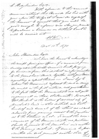
Document - Folder, Request for change of boundary, 1870
... Request for change of boundary...Document dated December 13 1870 re the change of boundary between the Greensborough Road Board and the Eltham Road Boards severance of land East of the Diamond Creek boundary. ...Eltham District Historical Society Inc 728 Main Rd Eltham melbourne Document dated December 13 1870 re the change of boundary between the Greensborough Road Board and the Eltham Road Boards severance of land East of the Diamond Creek boundary. ...Document dated December 13 1870 re the change of boundary between the Greensborough Road Board and the Eltham Road Boards severance of land East of the Diamond Creek boundary. Photocopy from Letters collection, Shire of Eltham. Folder 81 from Harry Gilham Collection 3 pageswingrove, herbert, alexander donaldson, john stevenson, roads -
 Ringwood and District Historical Society
Photograph, Boundary Photo across Dandenong Ck towards Ringwood (H E Parker Reserve). 1979
... Boundary Photo across Dandenong Ck towards Ringwood (H E Parker Reserve). 1979...Written on back of photograph, "Jan. 79 - boundary photo. Looking across Dandenong Creek towards Ringwood (H.E. ...Ringwood and District Historical Society 125A Warrandyte Road Ringwood North melbourne Written on back of photograph, "Jan. 79 - boundary photo. Looking across Dandenong Creek towards Ringwood (H.E. ...Written on back of photograph, "Jan. 79 - boundary photo. Looking across Dandenong Creek towards Ringwood (H.E. Parker Reserve) - ?? South East corner of Ringwood. From children's playground end of Derwent (?) St." -
 Ringwood and District Historical Society
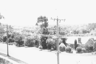
Photograph, Boundary photo. Heatherdale Rd. looking north east from Shibor Drive, Vermont. Jan. 1979
... Boundary photo. Heatherdale Rd. looking north east from Shibor Drive, Vermont. ...Written on back of photograph, "Jan. 79 - Boundary photo. Heatherdale Rd. looking north east. ...One of 3 that join up." Boundary photo. Heatherdale Rd. looking north east from Shibor Drive, Vermont. ...Written on back of photograph, "Jan. 79 - Boundary photo. Heatherdale Rd. looking north east. Taken at end of Shibor Dve (Vermont) (on high part end corner of school ground). One of 3 that join up." -
 Ringwood and District Historical Society
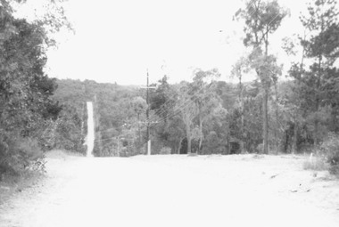
Photograph, Glenvale Road, North Ringwood - a Boundary looking north. 1979
... Glenvale Road, North Ringwood - a Boundary looking north. 1979...Glenvale Road - a Boundary looking north from top of a hill. 'Wild' country - few homes". ...Glenvale Road - a Boundary looking north from top of a hill. 'Wild' country - few homes". ...Written on back of photograph, "Jan. 79. Glenvale Road - a Boundary looking north from top of a hill. 'Wild' country - few homes". Looking north from Glenvale Road, near the corner of Kubis Drive, just near Cantala Crescent. -
 Eltham District Historical Society Inc
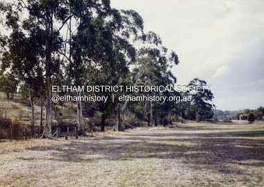
Colour Print, David Taylor, Western boundary, Eltham High School, c.1976
... Western boundary, Eltham High School...View looking north towards intersection of Susan Street and present-day Withers Way, behind the school near the western boundary. To the left of the photo is the housing development of Cronus Court. ...Eltham District Historical Society Inc 728 Main Rd Eltham melbourne View looking north towards intersection of Susan Street and present-day Withers Way, behind the school near the western boundary. To the left of the photo is the housing development of Cronus Court. ...View looking north towards intersection of Susan Street and present-day Withers Way, behind the school near the western boundary. To the left of the photo is the housing development of Cronus Court. Aerial photos for 1976 reflect the undeveloped landscape as viewed. By 1981 the estate was well established with all houses built.david taylor collection, eltham, eltham high school, cronus court, susan street, withers way -
 Melbourne Tram Museum
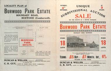
Ephemera - Real estate sale, Duncan & Weller Auctioneers, "Burwood Park Estate" Boundary Road, 1926
... "Burwood Park Estate" Boundary Road...Pamphlet advertising the sale of land at the Burwood Park Estate, Boundary Road Burwood, Saturday 4th September. ...Melbourne Tram Museum 8 Wallen Road Hawthorn melbourne Pamphlet advertising the sale of land at the Burwood Park Estate, Boundary Road Burwood, Saturday 4th September. ...Pamphlet advertising the sale of land at the Burwood Park Estate, Boundary Road Burwood, Saturday 4th September. Does not give the year, most likely 1926. Promotes the tram service, nearby shops, the suitability of the soil for gardening and other facilities. Has a photo of possibly W 259 at the terminus. The plan of sub-division shows 18 lots for sale.Demonstrates the style of land sale pamphlet including the availability of tram services to prospective purchasers.Pamphlet - folded - printed in two colours of cream coloured paper with photographs and plans.sale of land, trams, real estate, burwood park, burwood -
 Federation University Historical Collection
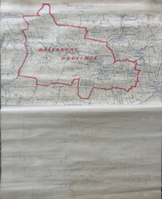
Map, Ballarat Municipalities and City Boundary
... Ballarat Municipalities and City Boundary....Bottom half is drawn directly onto linen and depicts Ballaarat City Boundary including street names. 'Scale about 20 chains to 1 inch'....Ballarat Municipalities and City Boundary. Map Map ...Piece of linen attached at top and bottom with wooden rails. Top half of linen has a paper map of Ballaarat Province and Surrounding Municipalities directly attached to it and reads 'Ballaarat Province' in red ink which outlines the greater Ballarat area with surrounding municipalities shown in blue. Scale is '8 miles to 1 inch'. Bottom half is drawn directly onto linen and depicts Ballaarat City Boundary including street names. 'Scale about 20 chains to 1 inch'.ballarat electorate, map, ballaarat province, ballarat to buninyong railway -
 Victorian Aboriginal Corporation for Languages
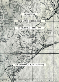
Book, K L Chappel, Surveying for land settlement in Victoria 1836-1960 : survey of the Vic-NSW boundary, survey of the Vic-SA boundary, 1996
... Surveying for land settlement in Victoria 1836-1960 : survey of the Vic-NSW boundary, survey of the Vic-SA boundary...Surveying for land settlement in Victoria 1836-1960 : survey of the Vic-NSW boundary, survey of the Vic-SA boundary Book K L Chappel ...A record of the early history of surveying for land settlement. Includes appendices on the border surveys between Victoria and South Australia and between Victoria and New South Wales.maps, b&w photographs, illustrationssurveying, land settlement -
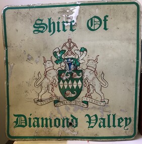 Greensborough Historical Society
Sign - Boundary Sign, Shire of Diamond Valley, Shire of Diamond Valley boundary sign, 1990s
... Shire of Diamond Valley boundary sign...This example of a Boundary Sign was one of many located on the edge of the Shire e.g. at Wattle Glen Station; at Yan Yean Road north of Bannons Lane; 2 on Plenty Road near Larundel and Bundoora Primary School; one on the Para Road bridge; on Wattletree Road Eltham and on Kurrak Road Yarrambat. ...Shire of Diamond Valley boundary sign Sign Boundary Sign Shire of Diamond Valley ...The Shire of Diamond Valley was a Local Government Area located about 20 kilometres northeast of Melbourne. The shire covered an area of 74.38 square kilometres and existed from 1964 until 1994. This example of a Boundary Sign was one of many located on the edge of the Shire e.g. at Wattle Glen Station; at Yan Yean Road north of Bannons Lane; 2 on Plenty Road near Larundel and Bundoora Primary School; one on the Para Road bridge; on Wattletree Road Eltham and on Kurrak Road Yarrambat. According to a former Shire employee, the signs were often stolen as quickly as they were replaced. This sign was removed when the Shire of Diamond Valley was dissolved in 1994 and is signed by a Shire employee, giving it strong provenance.Painted metal sign, cream background with green text and Shire of Diamond Valley crest.Inscribed in felt tip pen on back of sign: SDV: from Nov 1964 to 1994. 30 years. Ron Middleton, By-laws Officer and Ranger, from 9/84 to Nov 94 [signed] R. Middletonshire of diamond valley, boundary signs -
 Eltham District Historical Society Inc
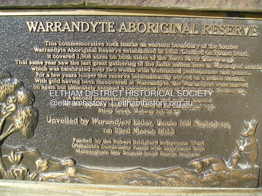
Photograph, Fay Bridge, Eastern boundary of former Warrandyte Aboriginal Reserve, North Warrandyte, 7 November 2016
... Eastern boundary of former Warrandyte Aboriginal Reserve, North Warrandyte...Two bronze commemorative plaques on rocks, unveiled by Wurundjeri Tribe Council Elders, mark two eastern boundaries of the former Warrandyte Aboriginal Reserve on the north and south sides of the Yarra. ...Plaque : Warrandyte Aboriginal Reserve This commemorative rock marks an eastern boundary of the former Warrandyte Aboriginal Reserve established in 1852. ...Two bronze commemorative plaques on rocks, unveiled by Wurundjeri Tribe Council Elders, mark two eastern boundaries of the former Warrandyte Aboriginal Reserve on the north and south sides of the Yarra. This project was initiated by Nillumbik Reconciliation Group in close association with Reconciliation Manningham and the Wurundjeri Tribe Council, as a means of commemorating the last great corroboree of the Kulin Nation which was held at Pound Bend in March 1852. This plaque is on the Nillumbuk side of the Yarra, accessed via The Boulevard, North Warrandyte. The plaque is set on a rock approximately 50 metres before the turning circle at the end of The Boulevard. Plaque : Warrandyte Aboriginal Reserve This commemorative rock marks an eastern boundary of the former Warrandyte Aboriginal Reserve established in 1852. Centred on Pound Bend, it covered 1,908 acres on both sides of the Yarra River (Birrarung). That same year saw the last great gathering of the Kulin nation here in Wurundjeri country which was celebrated over two weeks with traditional performance and games. For a few years longer the reserve intermittently served as a ration station.With gold having been discovered at Warrandyte, the Wurundjeri were moved on again but ultimately secured a permanent home at Coranderrk, Healesville. A second commemorative plaque and rock is located on the opposite bank of the Yarra and its confluence with Stony Creek. Melway ref : 23 C 9 Unveiled by Wurundjeri Elder, Uncle Bill Nicholson on 23rd March 2013 Funded by the Robert Bridgford Indigenous Trust (Nillumbik Community Fund) with assistance from Manningham City Council Small Grants Program Ref: Monument Autralia https://monumentaustralia.org.au/themes/culture/indigenous/display/99680-warrandyte-aboriginal-reserve-fay bridge collection, 2016-11-07, aboriginal reserve, north warrandyte, plaques, warrandyte aboriginal reserve -
 Sunshine and District Historical Society Incorporated
Map - City of Sunshine Boundaries 1994 Maps
... 4 maps (wall) depicting the City of Sunshine Boundaries...City of Sunshine Boundaries 1991 wall maps...City of Sunshine City of Sunshine Boundaries 1991 wall maps 4 maps (wall) depicting the City of Sunshine Boundaries Map City of Sunshine Boundaries 1994 Maps ...City of Sunshine Boundaries 1991 wall mapscity of sunshine -
 Eltham District Historical Society Inc
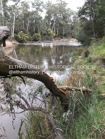
Photograph, Fay Bridge, Yarra River near the eastern boundary of former Warrandyte Aboriginal Reserve, North Warrandyte, 11 August 2023
... Yarra River near the eastern boundary of former Warrandyte Aboriginal Reserve, North Warrandyte...Eltham District Historical Society Inc 728 Main Rd Eltham melbourne Accessed via The Boulevard, North Warrandyte Fay Bridge Collection aboriginal reserve North Warrandyte Warrandyte Aboriginal Reserve 2023-08-11 1 images - born digital Yarra River near the eastern boundary of former Warrandyte Aboriginal Reserve, North Warrandyte Photograph Photograph Fay Bridge ...Accessed via The Boulevard, North Warrandytefay bridge collection, aboriginal reserve, north warrandyte, warrandyte aboriginal reserve, 2023-08-11 -
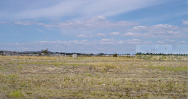
![Newspaper clipping [copy], Diamond Valley News, Councils mixed on boundary changes, 26/10/1994](/media/collectors/4f729f5697f83e03086015b8/items/55c1aeb92162f110e0f9418d/item-media/55c1aef02162f110e0f946f9/item-fit-380x285.jpg?cb=6) Greensborough Historical Society
Greensborough Historical SocietyNewspaper clipping [copy], Diamond Valley News, Councils mixed on boundary changes, 26/10/1994
... Councils mixed on boundary changes...Councils mixed on boundary changes Newspaper clipping [copy] Diamond Valley News ...Discusses the restructure of Eltham and Diamond Valley Shires in 1994. In this article, the present 'Nillumbik' is referred to as 'Montsalvat'.Newspaper clipping, one page, black and white image and black text.shire of diamond valley, shire of eltham, banyule -
 Eltham District Historical Society Inc
Newspaper - Newspaper article, Diamond Valley News, Councils mixed on boundary changes by Fiona Kaegi and Natalie Town, Diamond Valley News, October 26, p8, 1994
... Councils mixed on boundary changes by Fiona Kaegi and Natalie Town, Diamond Valley News, October 26, p8...Eltham District Historical Society Inc 728 Main Rd Eltham melbourne Council amalgamation shire of eltham Shire of Montsalvat Shire of Nillumbik 1994 City of Banyule City of Heidelberg Local Government Board Montsalvat Shire of Diamond Valley Newsprint; Newspaper, bound volume Councils mixed on boundary changes by Fiona Kaegi and Natalie Town, Diamond Valley News, October 26, p8 Newspaper Newspaper article Diamond Valley News ...council amalgamation, shire of eltham, shire of montsalvat, shire of nillumbik, 1994, city of banyule, city of heidelberg, local government board, montsalvat, shire of diamond valley -
 Eltham District Historical Society Inc
Postcard - Photograph, Shire of Nillumbik, Yarra River, southern boundary of the Shire of Nillumbik, c.2010
... Yarra River, southern boundary of the Shire of Nillumbik...Eltham District Historical Society Inc 728 Main Rd Eltham melbourne Nillumbik Shire Council c.2010 Arts Environment Heritage Postcard Birrarung Shire of Nillumbik Yarra River Postcard 10.5 x 14.8 cm Yarra River, southern boundary of the Shire of Nillumbik Postcard Photograph Shire of Nillumbik ...Nillumbik Shire Council c.2010 Arts Environment Heritagepostcard, birrarung, shire of nillumbik, yarra river -
 Eltham District Historical Society Inc
Photograph, Para Road, Montmorency, industrial area looking south from Plenty River Bridge on boundary of Shire of Eltham
... Para Road, Montmorency, industrial area looking south from Plenty River Bridge on boundary of Shire of Eltham...Eltham District Historical Society Inc 728 Main Rd Eltham melbourne 02076 montmorency (france) photo album montmorency para road plenty river industry Colour photograph Para Road, Montmorency, industrial area looking south from Plenty River Bridge on boundary of Shire of Eltham Photograph ...Colour photograph02076, montmorency (france) photo album, montmorency, para road, plenty river, industry -
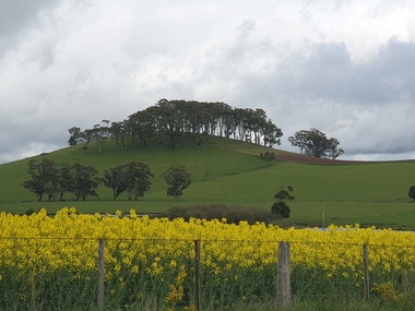
 Victorian Interpretive Projects Inc.
Photograph - Photograph - Colour, Clare Gervasoni, Wombat Hill near Boundary Church Road, Newlyn, 2014, 13/10/2014
... Wombat Hill near Boundary Church Road, Newlyn, 2014...PO Box 93R, Redan, 3350 goldfields hill boundary church road Wombat Hill Newlyn Treed Hill on the Daylesford-Dean-Ballarat Road. ...Treed Hill on the Daylesford-Dean-Ballarat Road. It is Wombat Hill.hill, boundary church road, wombat hill, newlyn -
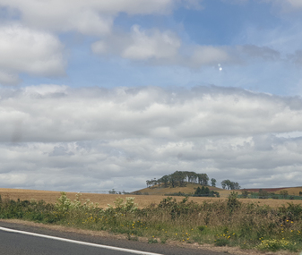
 Victorian Interpretive Projects Inc.
Photograph - Photograph - Colour, Clare Gervasoni, Wombat Hill near Boundary Church Road, Newlyn, 2020, 2020
... Wombat Hill near Boundary Church Road, Newlyn, 2020...PO Box 93R, Redan, 3350 goldfields hill boundary church road Wombat Hill Newlyn Treed Hill on the Daylesford-Dean-Ballarat Road. ...Treed Hill on the Daylesford-Dean-Ballarat Road. It is Wombat Hill.hill, boundary church road, wombat hill, newlyn -
 Victorian Interpretive Projects Inc.
Photograph - Photograph - Colour, Clare Gervasoni, Wombat Hill near Boundary Church Road, Newlyn, 2019, 2020
... Wombat Hill near Boundary Church Road, Newlyn, 2019...PO Box 93R, Redan, 3350 goldfields hill boundary church road Wombat Hill Newlyn Treed Hill on the Daylesford-Dean-Ballarat Road. ...Treed Hill on the Daylesford-Dean-Ballarat Road. It is Wombat Hill.hill, boundary church road, wombat hill, newlyn -
 Victorian Interpretive Projects Inc.
Photograph - Photograph - Colour, Clare Gervasoni, Wombat Hill near Boundary Church Road, Newlyn, 2020, 2020
... Wombat Hill near Boundary Church Road, Newlyn, 2020...PO Box 93R, Redan, 3350 goldfields hill boundary church road Wombat Hill Newlyn Treed Hill on the Daylesford-Dean-Ballarat Road. ...Treed Hill on the Daylesford-Dean-Ballarat Road. It is Wombat Hill.hill, boundary church road, wombat hill, newlyn -
Ringwood and District Historical Society
Envelope, Packet: Ringwood City Council Elections 1988-1991; Ward Boundary Changes, 1988
... Packet: Ringwood City Council Elections 1988-1991; Ward Boundary Changes...Ringwood and District Historical Society 125A Warrandyte Road Ringwood North melbourne City Council Elections 1988 Packet: Ringwood City Council Elections 1988-1991; Ward Boundary Changes Envelope ...City Council Elections 1988 -
 Ringwood and District Historical Society
Photograph, Mullum Mullum Creek, fenced garden of a Munro St property that has encroached into the creek boundary 29th October 1989, 1989
... Mullum Mullum Creek, fenced garden of a Munro St property that has encroached into the creek boundary 29th October 1989...Ringwood and District Historical Society 125A Warrandyte Road Ringwood North melbourne Digital photograph Mullum Mullum Creek, fenced garden of a Munro St property that has encroached into the creek boundary 29th October 1989 Photograph ...Digital photograph -
 Mortlake and District Historical Society
Photograph - Photograph - The old vicarage, Boundary Road, Mortlake, F.B.W. Stevenson, Photographer (on back)
... Photograph - The old vicarage, Boundary Road, Mortlake...The old vicarage was reduced to rubble reputedly by boys using gelignite in the 1950's; the remains can be seen in the paddock on Wagg's Lane. church anglican mortlake wagg lane waggs Written on the back: The Vicarage Mortlake Sepia rectangular photograph on cardboard backing Photograph - The old vicarage, Boundary Road, Mortlake Photograph Photograph - The old vicarage, Boundary Road, Mortlake F.B.W. ...Shows a bluestone house surrounded by lush, well-developed garden. House is in good order with 4 chimneys, a porch and water-tank. To the left, partially obscured by the shrubbery stands the bearded Rev.Wagg with hat. To the right is a girl around ?10 years old, with parasol and hat in her hands. This was Mortlakes' Anglican Vicarage from c. 1886 to c.1916 when present one was built next to St.James church in Shaw Street. House stood in Sagnol's paddock (Waggs Lane) until 1950's when it was demolished reportedly by a group of boys using dynamite!) Rev. Wagg was a long-serving and well-regarded Anglican minister who served Mortlake from 1886 to1916. Wagg's Lane takes its name from his former residency there. A new Vicarage was built c.1916 next to the church. The old vicarage was reduced to rubble reputedly by boys using gelignite in the 1950's; the remains can be seen in the paddock on Wagg's Lane.Sepia rectangular photograph on cardboard backingWritten on the back: The Vicarage Mortlakechurch, anglican, mortlake, wagg, lane, waggs -
 Nillumbik Shire Council
Video (HD): Ash KEATING, North Park Proposition (from the 'Urban Boundary Proposition' series)
... North Park Proposition (from the 'Urban Boundary Proposition' series)...North Park Proposition (from the 'Urban Boundary Proposition' series) Video (HD): Ash KEATING ...Video of artist painting the facade of a concrete warehouse into a ‘Trompe-l’oeil’ landscape painting using fire extinguishers as paint brushes. The warehouse slowly disappears into the landscape. -
Stawell Historical Society Inc
Map, Stawell Joint Venture, Map of Stawell showing Mining Lease Boundary and Freehold Land, September 1988
... Map of Stawell showing Mining Lease Boundary and Freehold Land...Stawell Historical Society Inc 46 Longfield St Stawell grampians mining gold map Stawell Joint Venture Map of Stawell showing Mining Lease Boundary and Freehold Land Map Stawell Joint Venture ...Stawell Joint Venturemining, gold, map