
Showing 63 items matching "boundary ward"
-
 Port Melbourne Historical & Preservation Society
Document - Electoral Roll, City of Port Melbourne, Boundary Ward, City of Port Melbourne, Voters' Rolls, 1983
... Electoral Roll, City of Port Melbourne, Boundary Ward...Voters Roll for City of Port Melbourne's Boundary Ward: list of electors entitled to be enrolled on Municipal Clerk's rolls....Voters' Rolls Document Electoral Roll, City of Port Melbourne, Boundary Ward City of Port Melbourne ...Prepared by the Town clerk's office. Voters Roll for City of Port Melbourne's Boundary Ward: list of electors entitled to be enrolled on Municipal Clerk's rolls.Voters' Rolls 1983/84 City of Port Melbourne, Electoral Province of Melbourne, Port Melbourne Division Sandridge Ward - List of electors entitled to be enrolled on Municipal Clerks' Rolls @ 29 July 1983.local government - city of port melbourne, town clerks, frederick charles jackson -
 Port Melbourne Historical & Preservation Society
Document - Electoral Roll, City of Port Melbourne, City of Port Melbourne, Voters Roll, City of Port Melbourne - Boundary Ward, Jul 1990
... Voters Roll, City of Port Melbourne - Boundary Ward...Voters roll, City of Port Melbourne 1990/91with a pink cover: List in alphabetical order of residents in Boundary Ward. Signature of A.D. Graham, Municipal Clerk, is on back page....Voters Roll, City of Port Melbourne - Boundary Ward Document Electoral Roll, City of Port Melbourne City of Port Melbourne ...Prepared by the Town Clerk's office. Voters roll, City of Port Melbourne 1990/91with a pink cover: List in alphabetical order of residents in Boundary Ward. Signature of A.D. Graham, Municipal Clerk, is on back page.local government - city of port melbourne, town clerks, david graham -
 Port Melbourne Historical & Preservation Society
Document - Electoral Roll, City of Port Melbourne, City of Port Melbourne, Voters Roll, City of Port Melbourne - Boundary Ward, 14 Jun 1990
... Voters Roll, City of Port Melbourne - Boundary Ward...Voters roll, City of Port Melbourne 14 June 1990 with a pink cover: List in alphabetical order of residents in Boundary Ward. Signature of A.D. Graham, Municipal Clerk, is on back page....Voters Roll, City of Port Melbourne - Boundary Ward Document Electoral Roll, City of Port Melbourne City of Port Melbourne ...Prepared by the Town Clerk's office. Voters roll, City of Port Melbourne 14 June 1990 with a pink cover: List in alphabetical order of residents in Boundary Ward. Signature of A.D. Graham, Municipal Clerk, is on back page.local government - city of port melbourne, town clerks, david graham -
 Sunshine and District Historical Society Incorporated
Administrative record - City of Sunshine - Commissioner Mr Alexander Alex George Gillon Collection 1976 - 1982 - Possible alternatives on ward boundary changes 20th March 1980, City of Sunshine, 20th March 1980
... City of Sunshine - Commissioner Mr Alexander Alex George Gillon Collection 1976 - 1982 - Possible alternatives on ward boundary changes 20th March 1980...This report presented to Council viable alternatives concerning the matter of Ward Boundary changes within the Municipality of Sunshine. ...Report to Sunshine City Council Possible Alternatives on Ward Boundary Changes 20th March 1980...This report presented to Council viable alternatives concerning the matter of Ward Boundary changes within the Municipality of Sunshine. ...This report presented to Council viable alternatives concerning the matter of Ward Boundary changes within the Municipality of Sunshine. The last re-subdivision of the Wards was back in 1951 but since then the city had experienced significant population growth, especially in the Western Ward which caused a disproportionate distribution of votes across the Wards.Report to Sunshine City Council Possible Alternatives on Ward Boundary Changes 20th March 1980 -
 Port Melbourne Historical & Preservation Society
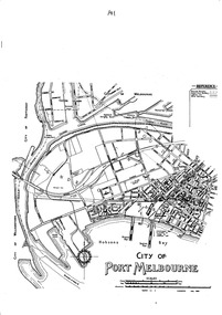
Map - Map of Port Melbourne, Jul 1992
... ...Boundary Ward...Map of Port Melbourne showing the three wards: Boundary, Centre and Sandridge....Map of Port Melbourne showing the three wards: Boundary, Centre and Sandridge. City of Port Melbourne Boundary Ward Centre Ward Sandridge Ward Local Government - City of Port Melbourne Black and white photo of map Map Map of Port Melbourne ...Map of Port Melbourne showing the three wards: Boundary, Centre and Sandridge.Black and white photo of mapcity of port melbourne, boundary ward, centre ward, sandridge ward, local government - city of port melbourne -
Ringwood and District Historical Society
Envelope, Packet: Ringwood City Council Elections 1988-1991; Ward Boundary Changes, 1988
... Packet: Ringwood City Council Elections 1988-1991; Ward Boundary Changes...City Council Elections 1988 Packet: Ringwood City Council Elections 1988-1991; Ward Boundary Changes Envelope ...City Council Elections 1988 -
Port Melbourne Historical & Preservation Society
Flyer - 1992 Port Melbourne Council Election, 02 It's time for a change, Jul 1992
... - Port Melbourne Electoral Material 1992 - Lyn Allison, Boundary ward...Kept by donor until 2018 local government - city of port melbourne elections lyn allison .02 In ink on back "Di" - Port Melbourne Electoral Material 1992 - Lyn Allison, Boundary ward .02 It's time for a change Flyer 1992 Port Melbourne Council Election The Letter Press Kwikkopy Printing Centre ...Produced in 1992 as two more women successfully ran for Port Melbourne City Council. Kept by donor until 2018 - Port Melbourne Electoral Material 1992 - Lyn Allison, Boundary ward .02 In ink on back "Di"local government - city of port melbourne, elections, lyn allison -
Port Melbourne Historical & Preservation Society
Document - Voter Rolls, City of Port Melbourne, Port Melbourne City Council, 1940s - 1970s
... Sandridge ward 1963. Boundary Ward 1963. Sandridge ward 1963. All wards late 1940s to early 1950s...Local Government - City of Port Melbourne Seven Voter lists, City of Port Melbourne. Boundary Ward, 1951. Centre ward 1951. Centre ward 1975. ...Seven Voter lists, City of Port Melbourne. Boundary Ward, 1951. Centre ward 1951. Centre ward 1975. Sandridge ward 1963. Boundary Ward 1963. Sandridge ward 1963. All wards late 1940s to early 1950slocal government - city of port melbourne -
 Port Melbourne Historical & Preservation Society
Card - City of Port Melbourne, council election, Jim MITCHELL, 1970s
... Election card for Jim MITCHELL, representative for Boundary Ward, for Port Melbourne City Council, c. 1970s...Election card for Jim MITCHELL, representative for Boundary Ward, for Port Melbourne City Council, c. 1970s Card City of Port Melbourne, council election, Jim MITCHELL ...Election card for Jim MITCHELL, representative for Boundary Ward, for Port Melbourne City Council, c. 1970sName and address handwritten by Jim Mitchell on reverse side.politics, local government - city of port melbourne, societies clubs unions and other organisations, james malcolm (jim) mitchell, australian labor party -
Port Melbourne Historical & Preservation Society
Document - Newsletters, Council activities, Cr Glen Cosham, Glen Cosham, 1974 - 1978
... 13 bulletins on Council activities, sent to Boundary Ward residents by then Councillor Glen Cosham between 1974 and 1978 (photocopies)...Retained by donor from his service on Port Melbourne Council from 1973 to 1978. local government - city of port melbourne glen cosham 13 bulletins on Council activities, sent to Boundary Ward residents by then Councillor Glen Cosham between 1974 and 1978 (photocopies) Document Newsletters, Council activities, Cr Glen Cosham Glen Cosham ...Retained by donor from his service on Port Melbourne Council from 1973 to 1978.13 bulletins on Council activities, sent to Boundary Ward residents by then Councillor Glen Cosham between 1974 and 1978 (photocopies)local government - city of port melbourne, glen cosham -
Port Melbourne Historical & Preservation Society
Flyer - Campaign Leaflets, 1974 Port Melbourne Council Election, 1974
... Campaign leaflets for 1974 Port Melbourne Council, Boundary Ward Election .01 - Michael Barbieri, independent .02 - Phillip Lang, ALP...Local Government - City of Port Melbourne Politics Societies Clubs Unions and other Organisations Michael Barbieri Phil Lang ALP Australian Labor Party Campaign leaflets for 1974 Port Melbourne Council, Boundary Ward Election .01 - Michael Barbieri, independent .02 - Phillip Lang, ALP Flyer Campaign Leaflets, 1974 Port Melbourne Council Election Pink Panther Pty Ltd Kosdown Printing ...Campaign leaflets for 1974 Port Melbourne Council, Boundary Ward Election .01 - Michael Barbieri, independent .02 - Phillip Lang, ALPlocal government - city of port melbourne, politics, societies clubs unions and other organisations, michael barbieri, phil lang, alp, australian labor party -
 Greensborough Historical Society
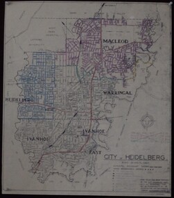
Maps, City of Heidelberg 1974, 1974c
... City of Heidelberg showing Municipal and Ward boundaries, prepared by City Engineers Department. ...Blueprint, 2 copies, one with some roads hand coloured, showing municipal and ward boundaries. Scale: 20 chains to 1 inch...City of Heidelberg showing Municipal and Ward boundaries, prepared by City Engineers Department. ...City of Heidelberg showing Municipal and Ward boundaries, prepared by City Engineers Department. Made for Council use; copies available for sale to the public.Blueprint, 2 copies, one with some roads hand coloured, showing municipal and ward boundaries. Scale: 20 chains to 1 inchG. M. Hutchins. Authorised charge 50c.city of heidelberg, heidelberg -
Port Melbourne Historical & Preservation Society
Document - Electoral Roll, City of Port Melbourne, City of Port Melbourne, Voters' Rolls, 10 Jul 1986
... This volume with pink cover, Boundary Ward....This volume with pink cover, Boundary Ward. Voters' Rolls Document Electoral Roll, City of Port Melbourne City of Port Melbourne ...Prepared by the Town Clerk's Office of the City of Port Melbourne. Voters' roll for 1987 in the electoral province of Melbourne, divided according to Port Melbourne Division, Municipal Wards, and certified by Fred. C. Jackson, Town Clerk. This volume with pink cover, Boundary Ward.politics, local government - city of port melbourne, town clerks, frederick charles jackson -
 Greensborough Historical Society
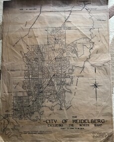
Map, City of Heidelberg, City of Heidelberg, - excluding the North Ward, 1959, 27/05/1959
... Map of City of Heidelberg showing municipal and ward boundaries; North Ward is excluded from this map....Map of City of Heidelberg showing municipal and ward boundaries; North Ward is excluded from this map. city of heidelberg heidelberg - maps "Scale 20 chns to an inch. ...Map of City of Heidelberg showing municipal and ward boundaries; North Ward is excluded from this map.Blue print map on fabric"Scale 20 chns to an inch. G.M.H. 27.5.59"city of heidelberg, heidelberg - maps -
Broadmeadows Historical Society & Museum
Map, City of Broadmeadows, 1978, January 1978
... It documents ward boundaries and street development prior to later municipal amalgamations....The map shows detailed street layouts and ward boundaries of the City of Broadmeadows as at January 1978. ...It documents ward boundaries and street development prior to later municipal amalgamations. ...This map reflects the administrative and suburban structure of the City of Broadmeadows in 1978, a period of significant suburban expansion in Melbourne's northern region. It documents ward boundaries and street development prior to later municipal amalgamations.The item is significant as a contemporaneous municipal map documenting the administrative divisions and urban layout of Broadmeadows in 1978. It provides insight into historical planning, suburban growth, and governance structures of the region.Framed printed paper map mounted on a masonite backing board, enclosed in a wooden frame. The map shows detailed street layouts and ward boundaries of the City of Broadmeadows as at January 1978. Paper exhibits age-related discolouration and spotting. Frame shows wear consistent with age.Recto (upper left): CITY OF BROADMEADOWS/Metric SCALE: 1:20000/DATE: JANUARY 1978broadmeadows (vic), municipal boundaries, uban planning, street maps, local government wards -
 Greensborough Historical Society
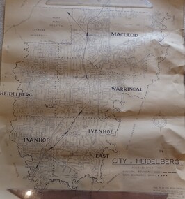
Map, City of Heidelberg. Engineers Dept, City of Heidelberg, 1960s
... Map showing municipal and ward boundaries, black text on light brown paper....Shire of Diamond Valley is shown to the north. city of heidelberg "Scale: 20 CHS = to 1 IN" Map showing municipal and ward boundaries, black text on light brown paper. ...Map of the City of Heidelberg from the Yarra River in the South to North of Watsonia Military Camp. Shire of Diamond Valley is shown to the north.Map showing municipal and ward boundaries, black text on light brown paper."Scale: 20 CHS = to 1 IN"city of heidelberg -
Whitehorse Historical Society Inc.
Pamphlet, Your City 1971, 1971
... Brief compendium of information about the city with names of councilors, ward boundaries etc...city of nunawading ward boundaries Brief compendium of information about the city with names of councilors, ward boundaries etc Brief compendium of information about the city with names of councilors, ward boundaries etc Your City 1971 Pamphlet Pamphlet ...Brief compendium of information about the city with names of councilors, ward boundaries etcBrief compendium of information about the city with names of councilors, ward boundaries etcBrief compendium of information about the city with names of councilors, ward boundaries etccity of nunawading, ward boundaries -
 Greensborough Historical Society
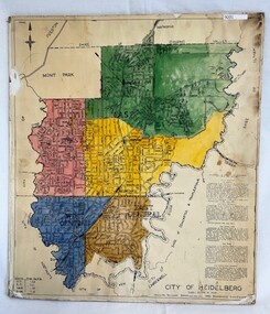
Poster - Map, City of Heidelberg, 1965c
... Map of the City of Heidelberg showing municipal boundaries and Wards are coloured. Scale 20 chains to 1 inch....Map of the City of Heidelberg showing municipal boundaries and Wards are coloured. Scale 20 chains to 1 inch. ...Map of the City of Heidelberg showing municipal boundaries and Wards are coloured. Scale 20 chains to 1 inch.An example of hard copy plans from the 1960s. Mainly from the Shire of Diamond Valley era (1964-1994).Colour map, pasted on card and laminated.Stamped and handwritten Council permissions, dates and other details. city of heidelberg, heidelberg - maps, local government -
 Bendigo Historical Society Inc.
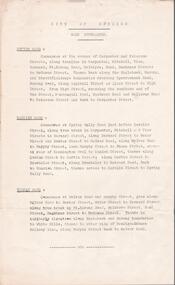
Document - CITY OF BENDIGO WARD BOUNDARIES
... One page typewritten document titled City of Bendigo Ward Boundaries. The document details the boundaries of the Sutton, Darling and Barkly wards....Document CITY OF BENDIGO WARD BOUNDARIES ...One page typewritten document titled City of Bendigo Ward Boundaries. The document details the boundaries of the Sutton, Darling and Barkly wards.government, local, city of bendigo -
Camberwell Historical Society
Pamphlet (Item), City of Boroondara
... Pamphlet on Boroondara City of Harmony with information about its logo and history of its name, and flyer on City of Boroondara electoral ward boundaries...Boroondara Camberwell Pamphlet on Boroondara City of Harmony with information about its logo and history of its name, and flyer on City of Boroondara electoral ward boundaries City of Boroondara Pamphlet Pamphlet City of Boroondara ...boroondara, camberwell -
University of Melbourne, Burnley Campus Archives
Map, Hawthorn, 1981
... Shows council ward boundaries. Amended several times between 17/9/1958 (P. ...Shows council ward boundaries. Amended several times between 17/9/1958 (P. ...Map of Hawthorn with legend of principal buildings. Shows council ward boundaries. Amended several times between 17/9/1958 (P. Linford) and 14/7/81hawthorn, buildings, p. linford, hawthorn council wards -
 Ringwood and District Historical Society
Newspaper, Scrapbook Clipping, Library Collection, Ringwood, Victoria
... Maroondah Council's recently announced ward boundaries have been published in the Government Gazette. ...Maroondah Council's recently announced ward boundaries have been published in the Government Gazette. ...Newspaper Clipping from the "Mail", 03-09-1996. P5. Yes to seven wardsMaroondah Council's recently announced ward boundaries have been published in the Government Gazette. Each of the seven was approved by Local Government Minister Rob Maclellan -
 Ringwood and District Historical Society
Map, Borough of Ringwood, Victoria - c.1950s
... A0-size (approx) map of named streets and lot-numbered properties within Borough of Ringwood ward boundaries. Colour-coded key marking Land Under Control of Council, Factory Areas, and Business Areas....A0-size (approx) map of named streets and lot-numbered properties within Borough of Ringwood ward boundaries. Colour-coded key marking Land Under Control of Council, Factory Areas, and Business Areas. ...A0-size (approx) map of named streets and lot-numbered properties within Borough of Ringwood ward boundaries. Colour-coded key marking Land Under Control of Council, Factory Areas, and Business Areas.Scale: 8 chains to 1 inch. North Ward, East Ward, South Ward. -
 Greensborough Historical Society
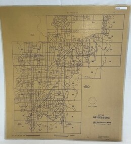
Poster - Map, City of Heidelberg, 1984
... boundaries in 1984 . Scale 1 inch to 160 feet. Side 2: MMBW Plans Yarra 2000, note Ward boundaries not updated on this plan....boundaries in 1984 . Scale 1 inch to 160 feet. Side 2: MMBW Plans Yarra 2000, note Ward boundaries not updated on this plan. ...Numbered grid map of the City of Heidelberg showing municipal boundaries in 1984 . Scale 1 inch to 160 feet. Side 2: MMBW Plans Yarra 2000, note Ward boundaries not updated on this plan.An example of hard copy plans from the 1960s. Mainly from the Shire of Diamond Valley era (1964-1994).Map printed on brown paper and laminated. Double sided.city of heidelberg, mmbw -
 Kew Historical Society Inc
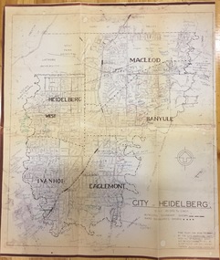
Plan, City Engineers Department (Heidelberg), City of Heidelberg Plan: Scale 20 chns to 1 inch, 1970-1993
... Plan of number of areas in the City of Heidelberg showing municipal and ward boundaries, subsequently annotated by the historian Gwen McWilliam, identifying significant landholdings, subdivisions and key dates.The base map was printed in 1970 and annotated c.1993. ...Primary source annotated by a distinguished local historian. city of heidelberg maps -- heidelberg (vic.) gwen mcwilliam Handwritten annotations by Gwen McWilliam, 1993 Plan of number of areas in the City of Heidelberg showing municipal and ward boundaries, subsequently annotated by the historian Gwen McWilliam, identifying significant landholdings, subdivisions and key dates.The base map was printed in 1970 and annotated c.1993. ...Gwen Barton McWilliam (nee: Nelson), OAM, BA (1933- ). Gwen McWilliam is well known as an authority on the history of Boroondara and the author of a large number of books and pamphlets about the City. She was awarded the medal of the Order of Australia in 2001 ‘for service to the community of Hawthorn and district, particularly through the research, documentation and publication of its history.’ Primary source annotated by a distinguished local historian.Plan of number of areas in the City of Heidelberg showing municipal and ward boundaries, subsequently annotated by the historian Gwen McWilliam, identifying significant landholdings, subdivisions and key dates.The base map was printed in 1970 and annotated c.1993. The plan was donated to the Kew Historical Society by Gwen McWilliam. Handwritten annotations by Gwen McWilliam, 1993city of heidelberg, maps -- heidelberg (vic.), gwen mcwilliam -
 Greensborough Historical Society
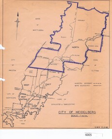
Map, City of Heidelberg, City of Heidelberg, 1962, 02/02/1962
... Map of City of Heidelberg showing boundaries of its six wards; North Ward is highlighted, covering Watsonia, Greensborough, part Bundoora, St Helena, Plenty, Yarrambat and Diamond Creek....Map of City of Heidelberg showing boundaries of its six wards; North Ward is highlighted, covering Watsonia, Greensborough, part Bundoora, St Helena, Plenty, Yarrambat and Diamond Creek. city of heidelberg heidelberg - maps City of Heidelberg Scale: 1" to 1 ml. ...Map of City of Heidelberg showing boundaries of its six wards; North Ward is highlighted, covering Watsonia, Greensborough, part Bundoora, St Helena, Plenty, Yarrambat and Diamond Creek.Blue print mapCity of Heidelberg Scale: 1" to 1 ml. G.M.H. 2.2.62city of heidelberg, heidelberg - maps -
 Broadmeadows Historical Society & Museum
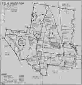
Map, City of Broadmeadows municipal map, February 1985, c. February 1985
... It records local government ward boundaries, infrastructure, reserves and neighbouring municipalities including Bulla, Whittlesea, Preston, Coburg, Essendon and Keilor. ...It records local government ward boundaries, infrastructure, reserves and neighbouring municipalities including Bulla, Whittlesea, Preston, Coburg, Essendon and Keilor. ...The map documents the City of Broadmeadows municipal area as it existed in February 1985. It records local government ward boundaries, infrastructure, reserves and neighbouring municipalities including Bulla, Whittlesea, Preston, Coburg, Essendon and Keilor. The map provides evidence of municipal organisation and land use in Broadmeadows during the mid-1980s.This map is significant as a historical record of the City of Broadmeadows shortly before substantial local government and urban development changes in Melbourne's northern suburbs. It documents municipal boundaries, infrastructure, public reserves and administrative divisions in 1985, providing valuable evidence for researchers studying local government, urban planning and community development in the Broadmeadows district.Single-sheet monochrome printed map on grey paper. Recto contains a detailed municipal map of the City of Broadmeadows. Verso is blank apart from labels and annotations. Fold marks visible.Recto, upper left: "CITY OF BROADMEADOWS" / "Metric Scale 1:40000" / "DATE FEB 1985" Verso, upper centre: "WI-3206" Verso, upper right: Handwritten and partially obscured notation present.broadmeadows (vic.), city of broadmeadows, local government, municipal boundaries, urban planning, roads, parks and reserves, cartography, melbourne northern suburbs, 1980s victoria. -
 Sunshine and District Historical Society Incorporated
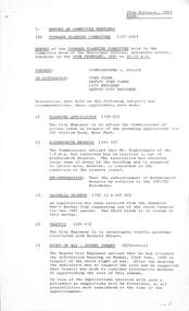
Administrative record - City of Sunshine - Commissioner Mr Alexander Alex George Gillon Collection 1976 - 1982 - Report of the forward planning committee meeting 24th February 1981, City of Sunshine, 24th February 1981
... Concerned with the Condition of the Reserve Sassella Park Application from Sunshine Mens Hockey Club Requesting Use of the Ground for the 1981 Season Traffic Barnett Street Sunshine Right of Way Sydney Street Albion Tree Watering Ward Boundaries Garbage Collection...Concerned with the Condition of the Reserve Sassella Park Application from Sunshine Mens Hockey Club Requesting Use of the Ground for the 1981 Season Traffic Barnett Street Sunshine Right of Way Sydney Street Albion Tree Watering Ward Boundaries Garbage Collection Foolscap sized document. ...Report of the forward planning committee meeting 24th February 1981 Planning Application Kinder Smith Reserve Y.C.W.A. Concerned with the Condition of the Reserve Sassella Park Application from Sunshine Mens Hockey Club Requesting Use of the Ground for the 1981 Season Traffic Barnett Street Sunshine Right of Way Sydney Street Albion Tree Watering Ward Boundaries Garbage Collectionkinder smith reserve, lily street, braybrook, sassella park, station road, deer park, sunshine mens hockey club, barnett street, sunshine, sydney street, albion -
 Sunshine and District Historical Society Incorporated
Administrative record - City of Sunshine Voters Rolls 1978 to 1980
... Over the years council ward boundaries are changed, added and deleted to suit the changing demographics and numbers of local residents. ...Over the years council ward boundaries are changed, added and deleted to suit the changing demographics and numbers of local residents. ...Council ward voting in Victoria is shaped by how each local council is divided into wards and the voting system used to elect councillors. The essentials are how wards are structured, how votes are cast and counted. Over the years council ward boundaries are changed, added and deleted to suit the changing demographics and numbers of local residents. The most recent change for the City of Brimbank and many other councils in Victoria was when in 2024, single‑member wards were introduced, that is, one councillor represents each ward. Voters then elect one candidate using the full preferential voting system.The Voters Rolls provides a 1979 to 1980 historical snapshot of the names and addresses of property owners in the former City of Sunshine.Particulars on the Roll are in the following order: - Property Assessment Number, Roll Number, Surname, Christian Names, Voter's Address, Owner Type, Situation or other description of rateable property. NOTE: Except as otherwise stated the rateable property is also the Voter's address. 1730.01 - City of Sunshine Voters Rolls - Central Ward 1978.jpg 1730.02 - City of Sunshine Voters Rolls - River Ward 1978.jpg 1730.03 - City of Sunshine Voters Rolls - Southern Ward 1978.jpg 1730.04 - City of Sunshine Voters Rolls - Western Ward 1978.jpg 1730.05 - City of Sunshine Voters Rolls - Eastern Ward 1979.jpg 1730.06 - City of Sunshine Voters Rolls - Central Ward 1979.jpg 1730.07 - City of Sunshine Voters Rolls - Southern Ward 1979.jpg 1730.08 - City of Sunshine Voters Rolls - River Ward 1979.jpg 1730.09 - City of Sunshine Voters Rolls - Central Ward 1980.jpg 1730.10 - City of Sunshine Voters Rolls - Western Ward 1980.jpg 1730.11 - City of Sunshine Voters Rolls - Southern Ward 1980.jpg 1730.12 - City of Sunshine Voters Rolls - River Ward 1980.jpg city of sunshine -
 Bendigo Historical Society Inc.
Document - ''CITY OF BENDIGO'': A DOCUMENT ''DISTRIBUTED FROM CIVIC OFFICES ON APPLICATION'' 1978
... Contents - Historical Information 1840-1891; ''How Bendigo got its name''; ''Discovery of Gold''; ''Bendigo's Big Year, 1871; a history of Bendigo - in three pages; ''Education in Bendigo''; ''Information on mining in Bendigo''; Bendigo Council incl. elections, officers, revenue, ward boundaries, Mayoral Roll 1856 - 1977; Town Clerk Roll - 1856 - 1977; Town Hall details; 1891 Plebiscite; Coat of Arms details....Contents - Historical Information 1840-1891; ''How Bendigo got its name''; ''Discovery of Gold''; ''Bendigo's Big Year, 1871; a history of Bendigo - in three pages; ''Education in Bendigo''; ''Information on mining in Bendigo''; Bendigo Council incl. elections, officers, revenue, ward boundaries, Mayoral Roll 1856 - 1977; Town Clerk Roll - 1856 - 1977; Town Hall details; 1891 Plebiscite; Coat of Arms details. ...''City of Bendigo'' a document ''Distributed from Civic Offices on application'' 1978. two copies, a. and b. with different handwritten annotations. Contents - Historical Information 1840-1891; ''How Bendigo got its name''; ''Discovery of Gold''; ''Bendigo's Big Year, 1871; a history of Bendigo - in three pages; ''Education in Bendigo''; ''Information on mining in Bendigo''; Bendigo Council incl. elections, officers, revenue, ward boundaries, Mayoral Roll 1856 - 1977; Town Clerk Roll - 1856 - 1977; Town Hall details; 1891 Plebiscite; Coat of Arms details.bendigo, council, bendigo history, coat of arms, town clerk roll, mayoral roll, mining in bendigo, council elections. town hall details.
