Showing 912 items matching bridges and buildings
-
 Kew Historical Society Inc
Plan, Melbourne & Metropolitan Board of Works : Borough of Kew : Detail Plan No.1302, 1910
The Melbourne and Metropolitan Board of Works (MMBW) plans were produced from the 1890s to the 1950s. They were crucial to the design and development of Melbourne's sewerage and drainage system. The plans, at a scale of 40 feet to 1 inch (1:480), provide a detailed historical record of Melbourne streetscapes and environmental features. Each plan covers one or two street blocks (roughly six streets), showing details of buildings, including garden layouts and ownership boundaries, and features such as laneways, drains, bridges, parks, municipal boundaries and other prominent landmarks as they existed at the time each plan was produced. (Source: State Library of Victoria)This plan forms part of a large group of MMBW plans and maps that was donated to the Society by the Mr Poulter, City Engineer of the City of Kew in 1989. Within this collection, thirty-five hand-coloured plans, backed with linen, are of statewide significance as they include annotations that provide details of construction materials used in buildings in the first decade of the 20th century as well as additional information about land ownership and usage. The copies in the Public Record Office Victoria and the State Library of Victoria are monochrome versions which do not denote building materials so that the maps in this collection are invaluable and unique tools for researchers and heritage consultants. A number of the plans are not held in the collection of the State Library of Victoria so they have the additional attribute of rarity.Original survey plan, issued by the MMBW to a contractor with responsibility for constructing sewers in the area identified on the plan within the Borough of Kew. The plan was at some stage hand-coloured, possibly by the contractor, but more likely by officers working in the Engineering Department of the Borough and later Town, then City of Kew. The hand-coloured sections of buildings on the plan were used to denote masonry or brick constructions (pink), weatherboard constructions (yellow), and public buildings (grey). The absence of buildings and or property in Kew facing the Yarra is the most notable feature of this plan. Walmer Street and its bridge stretched, then and now, from Studley Park Road to Victoria Street, Richmond. On the Richmond side of the Yarra, there was evidence in 1904 of industry (‘Wool shed’; Soap Works’) and entertainment (‘Skittle Alley’). In reality, another Plan (No.1303) shows Chinese Gardens bordering the Yarra on the Kew side and buildings in Young Street.melbourne and metropolitan board of works, detail plans, mmbw 1302, cartography -
 Glenelg Shire Council Cultural Collection
Photograph - Photograph - Bridge Construction, 30/05/1957
Port of Portland Authority ArchivesFront: Back- 'Garden street bridge 1957 western approach railway from north west.'- black biro '30/5/57' - pencilport of portland archives -
Port Melbourne Historical & Preservation Society
Photograph - Large wooden framed colour panorama photograph of Port Melbourne waterfront, Alison Kelly
Framed photograph. Taken from old Mission to Seamen building towards Station Pier. Shows Centenary Bridge and Abel Tasmanbuilt environment, piers & wharves, centenary bridge, abel tasman, natural environment, maritime -
Port Melbourne Historical & Preservation Society
Document - Scrapbook, Newspaper clippings regarding West Gate Bridge, Len Greaney, 1970s
Scrapbook of newspaper clippings kept by Len Greaney regarding West Gate bridge. Now as loose pages (see History of item) the pages came from the "Sun" and the "Herald" newspapers. These pages are related to the building and the opening of the bridge.engineering - bridges, west gate bridge, deaths and funerals, len greaney, john laino, bill snowden, frank piermarini, desmond gibson, fred upsdell, jack grist, jouzof ozeus, george tsehilios -
Port Melbourne Historical & Preservation Society
Photograph - Various buildings, Port Melbourne, Ron Laing, 1990s
Part of Ron Laing's collection of photographs recording Port Melbourne over a thirteen year period. Donated to the PMH&PS by the photographer.A set of 16 colour photographs by Ron Laing covering the Herald and Weekly Times building, the ex Borer's Bakery ovens and buildings, view from Coles parking area, Bridge Street industrial medical clinic and HMAS Lonsdale building 1990sbuilt environment - commercial, built environment - civic, ron laing -
 Bendigo Military Museum
Postcard - SOUVENIR POSTCARD, Photochrom Co Ltd, C. WW2
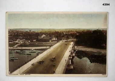
... bridges ...Part of the Frederick Davey DFC RAAF collection. refer Cat No 3536P for his service records.Post card, rectangular shape featuring a colour photograph of a bridge over a river with buildings in the back ground, vehicles are crossing the bridge, boats moored on the river, on the back printed in black type are publication details and space for correspondence and address.postcards, souvenirs, bridges -
Port Melbourne Historical & Preservation Society
Photograph - Bridge Street, Then and Now series, David Thompson, 1996
Taken 1996 by David Thompson for "Then and Now""Bridge St - Then and Now" series. Bridge street, taken from near the tram crossing, looking towards Bay Street. Shows Station Hotel building, which had been converted into a private residence. (no 587 from series)built environment - commercial, built environment - domestic, engineering - roads streets lanes and footpaths, david thompson, bridge street, station hotel -
 Bendigo Historical Society Inc.
Document - Newspaper Articles from Bendigo Advertiser
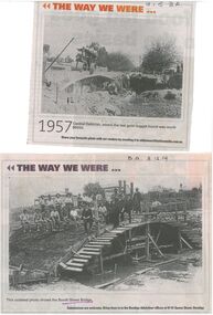
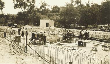
In 1867, Frenchman Joseph Monier patented the use of metal reinforced concrete for use in horticultural troughs. Francois Hennebique expanded this idea into a general construction technique including for the construction of bridges bridges with the first bridge built in 1875. In Victoria, Monash and Anderson, representatives of the Australian patent holders and later Victorian patent holders. The Bendigo Monier Bridges were built between 1901 and 1902. Monash's contribution was not in the actual technology but in the promotion and defence of the new technology that was faced by much doubt and scepticism.Series of Bendigo Advertiser articles on the theme of Monier Bridges. 5 articles from "Discover Bendigo" by James Lerk. 1999 1 article from "History Lives" by Jim Evens titled 'Building History Bridges" 2014 2 black and white photos from "The Way we Were" featuring the construction of the Booth Street Bridge 2014 and the collapse of the King Street bridge 2015monier bridges, engineering -
 Kiewa Valley Historical Society
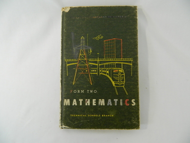
Book - Maths, Wilke and Co P/L, Form Two Mathematics, 1965
Educational book for teaching mathematics in Form 2 in Victoria. Kerrie Davies lived in the Kiewa Valley on a dairy farm.Historical: Comparison of the teaching of Mathematics in Victorian schools. Provenance: Davies family.Dark green hard covered book with sketch of power line, bridge, multi storey building and train in yellow and re. Writing in white.Education Department of Victoria (in white but coloured in) / Form Two / Mathematics / Technical Schools Branch Inside back of cover some scribbled maths. On first page: Kerrie Davieseducation. schools. davies family. mathematics. -
Tatura Irrigation & Wartime Camps Museum
Sketch, 1943
Josef Thum was a Austrian artist in Camp 13, as a POW. Ken Hill was a member of AAAS - Mobile Cinema Unit 36 around 1946-47 and based at Murchison. After hostilities ceased, Thum was permitted to assist Ken Hill in the presentation of "pictures" as was the common term of the period, each time there was a screening at MurchisonBlack and white pencil sketch of a bridge, Church Spire and building in Melbourne. Dated 17.8.43. A piece of tissue paper is attached to cover the sketch."melbourne", sketch, thum j, hill k, aaas, camp 13, tatura, illustrations, pencil -
Port Melbourne Historical & Preservation Society
Photograph - Missions to Seamen building, Port Melbourne, Alison Kelly, 1990
Donated to the Society by the photographer Alison KellyColour photograph of the west end of Missions to Seamen building from beside Centenary Bridge c1990; water tower of Engine Works in backgroundcentenary bridge, missions to seamen -
 Ringwood and District Historical Society
Photograph, Building the old Ringwood baths in Ringwood St 1934
Black and white photograph. 2 copies- 1 large, 1 small.Typed below photograph, "Building the old Ringwood baths in Ringwood St. The car is in Ringwood St. and the bridge over the Mullum Creek can be seen. 1934". -
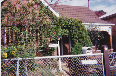 Port Melbourne Historical & Preservation Society
Photograph - Mandalay',163 Bridge Street, Port Melbourne, Pat Grainger, Mar 1998
Proposal to demolish and develop two 2 storey houses on the site were taken to Administrative Appeals Tribunal by neighbours and PMH&PS members, December 1997. Appeal was lost.Small colour photo of 163 Bridge Street ('Mandalay') Feb 1998 after it had been approved for demolition for the building of two town housesbuilt environment - domestic, mandalay, bridge street -
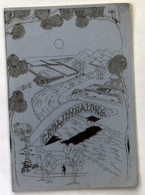 Orbost & District Historical Society
book, Croajingalong 1987, 1987
The name Croajingolong derives from the Australian Aboriginal Krauatungalung words galung, meaning "belonging to" and kraua, meaning "east". This is the thirty-ninth edition of the annual magazine of Orbost High School. The magazine belonged to Mary Gilbert, a former teacher at the school. Orbost High School / Orbost Secondary College has played a significant part in the education of senior students in the Orbost district . It is the sole senior educational institution. This item is representative of its history. This 39th edition of the magazine is a useful reference tool.A magazine type publication, titled Croajingalong. It has 84 pp. The cover is pale blue with black print drawings of a river, bridge, farmland,trees and buildings.magazine-croajingalong orbost-high-school -
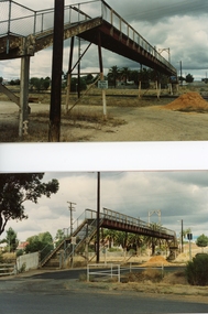 Stawell Historical Society Inc
Photograph, Railway Step Bridge Stawell 1991 -- 4 Photos 2 on one page & 2 Individual Photos
Series of four photos of Railway Step Bridge Stawell 1991Four (4) Colour Photographs, two on one page and 2 individual Photographs.The Two photographs one showing a footbridge in the distance with two cement pipes in front, and a pile of soil further back. A Truck is parked under the bridge. Buildings are in the distance on the lsft side. The Lower photograph is showing the bridge almost dismantled with the surfces of the bridge being held by two cranes with a person on the brdge. The other two photgraphs show the bridge from the groundlooking across the railway tracks one is a clsoe up of the bridge. On the rear of the tow Individual Photographs 224-2a on the top from the left Stawell Old Railway Bridge Bottom left corner ST1-2 224-2b From top left Stawell Old Railway bridge 1991. Bottom left ST1-4stawell, railways -
Port Melbourne Historical & Preservation Society
Photograph - Large wooden framed colour panorama photograph of Port Melbourne waterfront, Alison Kelly
Framed photograph. Taken from Station Pier admin building approx 1990. Shows Engine Works; London Hotel; Swallow & Ariell; West Gate Bridgebuilt environment, piers & wharves, commonwealth government engine works, london family hotel, swallow & ariell ltd, west gate bridge, engineering - bridges, natural environment - beaches and foreshore -
Clunes Museum
Work on paper - Pastel Drawing, Pollie Price, Untitled, 1897
... Buildings ...Unknown.1 Pastel drawing in timber frame with gold edging on frame. Subject: drawn on a pale brown background a man and woman standing on a wooden bridge, another man in a boat on the water and another standing in the water. Trees in front of buildings in the background. .2 Pastel drawing in timber frame with gold edging on frame. Subject: 2 people in a boat , stone arched bridge and trees in front of tall buildings in the background .1 Signed at bottom right hand corner "Pollie Prince"landscape, buildings -
Halls Gap & Grampians Historical Society
Photograph - Photocopy, C 1925
... Bridges ...The woman's name is Mavis Klauss and the boy is Arthur Klauss. The bridge is over the McKenzie Creek at Zumsteins. The Klauss family often camped in this area.The photo shows a woman and boy sitting on a bridge dangling their feet over a wide creek. A horse is teathered in the background on the left of the photo, where a building can also be seen.people, klauss, structures, bridges -
Port Melbourne Historical & Preservation Society
Photograph - Panorama, Centenary Bridge and the Port Melbourne foreshore, Alison Kelly, 1990
Refer 1725 for full Alison Kelly collection and separate photos from this panoramaPanorama of Centenary Bridge and the Port Melbourne foreshore taken from the roof of the Missions to Seamen building, 1990. Made up of 8 colour photographs. Alison Kelly collection.piers and wharves - station pier, piers and wharves - princes pier, centenary bridge, alison kelly -
 Sunbury & District Heritage Association Inc
Photograph
... bridges ...The single span bluestone bridge is on the Calder Highway at the base of Corkscrew Hill between Gap Road and the town of Gisborne. In the early 1990s the highway was widened and dual carriageways constructed, as a result the traffic no longer travelled along the winding Corkscrew Hill road. The bridge still stands between the two carriageways. A black and white photograph with a cream border of a single arched stone bridge spanning a watercourse. Small bushes are growing in the foreground and there are some buildings dotted across the hill in the middle distance.bridges, corkscrew hill, calder highway -
Glenelg Shire Council Cultural Collection
Photograph - Photograph reprint of a scan of a photograph - Bridge Inn at Casterton (1906 flood), Victoria, n.d
Vern McCallum CollectionReprint of a scan of a black and white photograph. Image shows Bridge Inn, in centre, surrounded by Hoodwaters, as are all other buildings in this photo. Print mounted on a white archival mount board frame. -
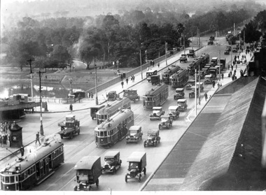 Ballarat Tramway Museum
Photograph - Black & White Photograph/s, 1930's
Black and white photo going to sepia toned, of about 11 W2's and many motor vehicles on Princes Bridge Melbourne, taken from the tower on Flinders Street station building, during the late 1930's. Many people on bridge, traffic jam of motor vehicles on the bridge itself. Note buildings at the Batman avenue terminus. Can see a tram trolley pole of a tram in Batman Avenue. No curve from Batman Ave. into Swanston St. At least two of the trams do not have route number boxes. There are a number of delivery vehicles in the photograph, but no horse drawn vehicles are to be seen.trams, tramways, melbourne, princes bridge, flinders st. station, batman ave., tram 321 -
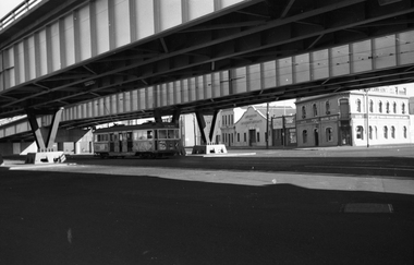 Melbourne Tram Museum
Negative, Wal Jack, 11/03/1962 12:00:00 AM
Black and white negative, by Wal Jack, of W5 684, West Coburg Route 55 inbound passing under the Kingsway over bridge and about to cross City Road. The bridge was opened to traffic during 1961. In the background is the Main Point Building Centre, a shop advertising Turf Cigarettes, J McCann Lime and Cement.trams, tramways, kingsway, city road, west coburg, route 55, w5 class, tram 684 -
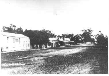 Tarnagulla History Archive
Photographs: Buildings in Newbridge near Loddon River bridge, Buildings in Newbridge near Loddon River bridge, 1908 (original image)
... Buildings in Newbridge near Loddon River bridge ...Depicts at left, Petersen's bakery, a store shed, Simpson's storekeepers and Simpson's Hotel. Hollands blacksmith shop & wheelwrights on right opposite bakery. Murray Comrie Collection. Three copies of a monochrome photograph, image depicts buildings in the eastern approach to the Loddon River bridge at Newbridge This is a fairly dark copy of an older original. Copy probably made by Murray Comrie in the 1960s.newbridge, loddon river, bridge, shops, stores, businesses, hotels, simpsons, petersens, bakery -
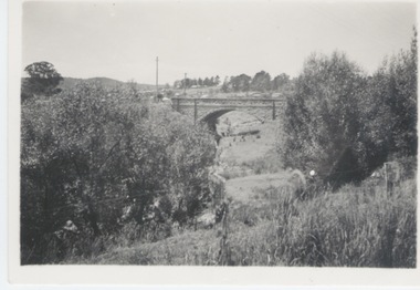
Malmsbury Historical Society
Photograph (Item), Malmsbury Gutters Near Coliban Bridge, Malmsbury ca1990
Buildings - Coliban Bridge -
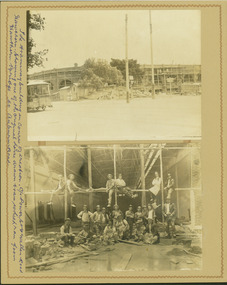 Kew Historical Society Inc
Photograph - Hawthorn Tram Depot during construction, 1915
One of a series of photographs, taken by Edgar James Dower in the second decade of the twentieth century. Born and raised in Olinda, his family later moved to Surrey Hills. He worked as an adult as a clerk in the city office of the Metropolitan Gas Company, and in his role as a 'collector', he was able to photograph scenes including the construction of tramlines and associated buildings in Kew, Hawthorn, Camberwell and Surrey Hills. Later he established a real estate agency with his brother - the E.J. Dower Real Estate Agency, Dandenong Office.The image is an historically significant record of the development of transport infrastructure which was used to connect Victorians in the first two decades of the twentieth century. This development resulted from increases in population and the consequent extension of Melbourne's suburbs. The photographs, both individually and collectively, richly detail the labour of workers and the tools and machinery used to create and extend Melbourne's tram network in the years preceding and during World War 1.Two faded original horizontal photographs, mounted on vertical card showing external and internal features of the Hawthorn Tram Depot during its construction phase. The top photo shows a panoramic view of the exterior while the second photo shows workers posed within the building.Recto: "The tramways building in course of creation. C/r of Power St & Wallen Road, Hawthorn. Showing one of the original horse drawn trams which ran from Hawthorn Bridge to Auburn Road".. theme --- travelling by tram, theme -- connecting victorians by transport and communications, tramways -- hawthorn -
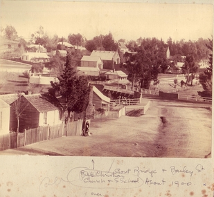 Clunes Museum
Photograph, 1900
GOVERNMENT BRIDGE AND BUILDINGS OF CLUNESSEPIA PHOTOGRAPH OF CLUNES BUILDINGS AND GOVERNMENT BRIDGE.TAKEN IN CRESWICK ROAD, SHOWING BIBLE CHRISTIAN CHURCH IN BAILEY STREET ABOUT 1900.GOVERNMENT BRIDGE AND BAILEY STR.BIBLE CHRISTIAN CHURCH AND SUNDAY SCHOOL. ABOUT 1900local history, photography, photographs, bridges and buildings -
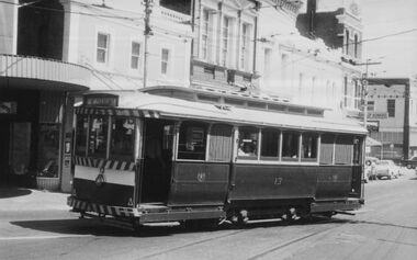 Ballarat Tramway Museum
Photograph - Digital image, c1971
Yields information about Ballarat streetscape and its trams in the closing days of the SEC tramway system.Digital image from a black and white print of tram 13, turning from Bridge St into Main Road outbound for Mt Pleasant with the various buildings on the southside in the background. Photo by Marc Dahlstrom c1971. On rear is the Marc Dahlstrom stamp.trams, tramways, bridge st, stones corner, tram 13 -
 Melbourne Tram Museum
Photograph - Digital Image, Kevin O'Reilly, series of three images of the Hawthorn Bridge over the Yarra, c1930, c1930's
Image from CD (Compact Diskette for use in computers) - see Reg Item 135. A series of three images of the Hawthorn Bridge over the Yarra, c1930, during the era with problems with the bridge. See separate article for more details. Richmond 6, Richmond, Richmond 3 on the CD as original files. .1 - Looking from the south west, at the Hawthorn bridge with the temporary wooden bridge being constructed on the south side. Has the cable tram depot in the photo and part of the Burnley racing course. Temporary track on the north side of the steel bridge and crossings can be seen. .2 - Looking along Bridge Road to the east with Hawthorn Bridge in the middle of the photograph. Shows the industrial and residential areas, Hawthorn Railway Station and part of the Burnley Race course, the cable tram depot building. W class tram in Church St Hawthorn and W class tram crossing the bridge on the north side temporary track. Note the cable tram used as a shelter on the north east corner of the bridge. .3 - Looking south along River St towards Bridge Road, with the Yarra River and Hawthorn Bridge on the left side of the photograph. Shows the industry in the area at the time, wool and skin Merchants, north side of the cable depot, housing and the outlook to the river!trams, tramways, hawthorn, yarra river, burnley, richmond, hawthorn bridge -
Port Melbourne Historical & Preservation Society
Photograph - Bridge Street, Port Melbourne, Meredith Turnbull, Dec 1996
Meredith Turnbull photographed this series in 1996 to record the rapidly changing streetscape, which had already had a number of old houses replaced by concrete two-storey structures under the State government's urban consolidation policyFrom a series of 70 colour photos recording all buildings in Evans Street from Graham Street overpass to Ingles Street, as photographed from the railway reservation, by Meredith Turnbull in December 1996 - Bridge StreetHouse numbers noted on backbuilt environment - domestic, meredith turnbull