Showing 199 items matching "building permit"
-
 Federation University Historical Collection
Document, City of Ballarat - Building Permit for Grant Street, South Side, East of Armstrong Street
... City of Ballarat - Building Permit for Grant Street, South Side, East of Armstrong Street......Building Permit...Pale blue/green A4 document - City of Ballarat - Building Permit for Grant Street, South Side, East of Armstrong Street issued to the School of Mines Ballarart...Barker Library (top floor) Mount Helen goldfields School of Mines Ballarat, is a predecessor of Federation University City of Ballarat Ballarat School of Mines The Ballarat School of Mines and Industries J.B. Menhennet Building Permit Recreation Building Number stamp on top right hand corner Pale blue/green A4 document - City of Ballarat - Building Permit for Grant Street, South Side, East of Armstrong Street issued to the School of Mines Ballarart City of Ballarat - Building Permit for Grant Street, South Side, East of Armstrong Street Document ...School of Mines Ballarat, is a predecessor of Federation UniversityPale blue/green A4 document - City of Ballarat - Building Permit for Grant Street, South Side, East of Armstrong Street issued to the School of Mines BallarartNumber stamp on top right hand corner city of ballarat, ballarat school of mines, the ballarat school of mines and industries, j.b. menhennet, building permit, recreation building -
Bendigo Historical Society Inc.
Document - Application for a Building Permit, 1959
... Application for a Building Permit ...city of bendigo building permit...Application for a Building Permit for 26 Raglan Street Bendigo 1. ...History House 11 Mackenzie Street Bendigo goldfields Parry Collection history bendigo J S Parry Collection city of bendigo building permit Application for a Building Permit for 26 Raglan Street Bendigo 1. ...Parry CollectionApplication for a Building Permit for 26 Raglan Street Bendigo 1. Application for Permit to the City of Bendigo by Mr J Parry 3 Yandoit St Bendigo for a cement shed as detailed. The receipt is attached for 10 shillings. 2. Hand Drawn plan of the laundry (Shed) proposed for Mr J Oudijn, scale 1/4 inch = 1 foot, signed and stamped by the City of Bendigo.history, bendigo, j s parry collection, city of bendigo building permit -
 Eltham District Historical Society Inc
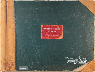
Register, Building Permit Register, Shire of Eltham, 1949-1960
... Building Permit Register, Shire of Eltham......building permit register...Red fabric in centre of front cover with "Building Permit Register - Shire of Eltham" lightly embossed with silver print. 39.0 x 52.5 x 6.5 cm Arnall & Jackson label on inside end sheets ( both ends), Printers, Lithographers, Bookbinders, Publishers, Manufacturing Stationers, 115 Barkly St. ...Typically, last three columns not filled in. 326 pages arranged in Alphabetical tabs; 133 pages with entries. Building Permit Register, Shire of Eltham Register ...Register Book, Hard cover, tan suede leather bound spine and corners on both covers, with green fabric on 5mm thick covers. Red fabric in centre of front cover with "Building Permit Register - Shire of Eltham" lightly embossed with silver print. 39.0 x 52.5 x 6.5 cm Arnall & Jackson label on inside end sheets ( both ends), Printers, Lithographers, Bookbinders, Publishers, Manufacturing Stationers, 115 Barkly St. West, Brunswick, Repeat Order No. A27956 Special print with each page headed with "Shire of Eltham", divide into columns of Date, Description, Lot No., Locality, L.P. or C.A., Riding, Cost, Owner name and address, Builder name and address, Application, Permit No. Commenced, Completed, Capital Value, N.A.V. Typically, last three columns not filled in. 326 pages arranged in Alphabetical tabs; 133 pages with entries. Label adhered to front cover "Series 67 Item 79"shire of eltham archives, building permit register, shire of eltham -
 Wonga Park Community Cottage History Group
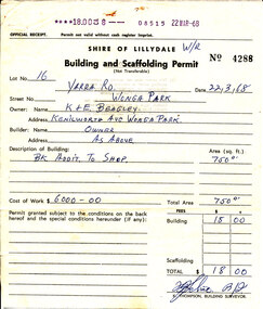
Document - Building and Scaffolding Permit, issued 22/3/1968 for the extension to Beagley's shop in Wonga Park
... Building and Scaffolding Permit...22/3/1968 Shire of Lillydale Building and Scaffolding Permit for extension to Beagley’s shop...Wonga Park Community Cottage History Group Unit 1, 9 – 13 Old Yarra Road Wonga Park melbourne 22/3/1968 Shire of Lillydale Building and Scaffolding Permit for extension to Beagley’s shop issued 22/3/1968 for the extension to Beagley's shop in Wonga Park Document Building and Scaffolding Permit ...22/3/1968 Shire of Lillydale Building and Scaffolding Permit for extension to Beagley’s shop -
 Wangaratta High School
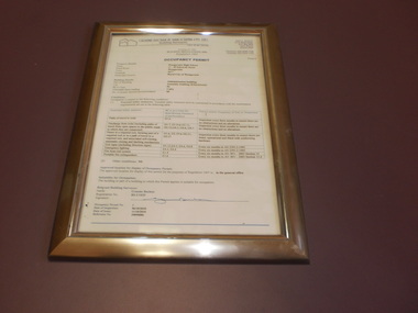
WHS Framed Certificate, 2010
... White Administration building occupancy permit, in a gold frame...LTD. Building Surveyors OCCUPANCY PERMIT...LTD. Building Surveyors OCCUPANCY PERMIT White Administration building occupancy permit, in a gold frame WHS Framed Certificate ...White Administration building occupancy permit, in a gold frameGRAEME BUCHAN & ASSOCIATES PTY. LTD. Building Surveyors OCCUPANCY PERMIT -
 Phillip Island and District Historical Society Inc.
Newspaper Clipping
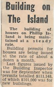
... Article about the building permits for Phillip Island issued at the rate of 12 a month....Phillip Island and District Historical Society Inc. phillip-island-and-the-bass-coast Article from a collection of newspaper clippings from October 1968 to July 1971 phillip island building permits Article about the building permits for Phillip Island issued at the rate of 12 a month. ...Article from a collection of newspaper clippings from October 1968 to July 1971Article about the building permits for Phillip Island issued at the rate of 12 a month.phillip island, building permits -
 Greensborough Historical Society
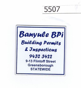
Refrigerator magnet, Banyule BPI, 2000c
... "Building permits and inspections", phone number and address at 9-13 Flintoff Street...Greensborough Historical Society 34A Glenauburn Road Lower Plenty Lower Plenty melbourne Business now operating from Level 3/1 Flintoff Street Greensborough 3088, Tel. 9433 7777 business cards building permits "Building permits and inspections", phone number and address at 9-13 Flintoff Street Refrigerator magnet, priinted in blue on white Banyule BPI Refrigerator magnet Banyule BPI ...Business now operating from Level 3/1 Flintoff Street Greensborough 3088, Tel. 9433 7777Refrigerator magnet, priinted in blue on white"Building permits and inspections", phone number and address at 9-13 Flintoff Streetbusiness cards, building permits -
Ringwood and District Historical Society
Letters, Heatherdale Pre-School Association: Building Opening, General letters, building permits etc. 1953, 1951-2
... Letters General plus 1952 Fair. Building permits. Equipment requirements. First year of operation 1953. ...Letters General plus 1952 Fair. Building permits. Equipment requirements. First year of operation 1953. ...Heatherdale Pre-School Association. First year of operation 1953. Location Yallourn Parade, Ringwood. Building Opening.Documents from Heatherdale Pre-School Association. Building Opening. Letters General plus 1952 Fair. Building permits. Equipment requirements. First year of operation 1953. Location Yallourn Parade, Ringwood.File and Letters -
 Sunshine and District Historical Society Incorporated
Archive - City Of Sunshine Statistics 1966
... City of Sunshine Staff Private Street Construction Development of Playing Fields Infant Welfare Centres and Pre-School Centres Rate Revenue Building Permits Income Population Loan Liabilities...City of Sunshine City of Sunshine Staff Private Street Construction Development of Playing Fields Infant Welfare Centres and Pre-School Centres Rate Revenue Building Permits Income Population Loan Liabilities Foolscap typed report Archive City Of Sunshine Statistics 1966 ...In 1966, at the time of the opening and inspection of the new Municipal Offices in Alexandra Avenue Sunshine, the Council produced these interesting statistics depicting the growth of the Municipality in the Post World War 2 period.City of Sunshine Staff Private Street Construction Development of Playing Fields Infant Welfare Centres and Pre-School Centres Rate Revenue Building Permits Income Population Loan Liabilitiescity of sunshine -
 Whitehorse Historical Society Inc.
Article, Out on the roof tiles, 1994
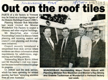
... City of Nunawading has recently introduced a front desk service where residents can obtain information about requirements for subdivisions, engineering and building permits....City of Nunawading has recently introduced a front desk service where residents can obtain information about requirements for subdivisions, engineering and building permits. Out on the roof tiles Article Article ...Parts of Monier Wunderlich tile factory in Vermont may be listed on a heritage register of the Historic Buildings Council.Parts of Monier Wunderlich tile factory in Vermont may be listed on a heritage register of the Historic Buildings Council. City of Nunawading has recently introduced a front desk service where residents can obtain information about requirements for subdivisions, engineering and building permits.Parts of Monier Wunderlich tile factory in Vermont may be listed on a heritage register of the Historic Buildings Council. tile factories, monier wunderlich tile factory, historic buildings, abbott, kevin, maclellan, rob, strong, ray, tuckerman, graeme -
 Ballarat Tramway Museum
Document - Personal Papers, Warren Doubleday, "Depot Extensions", "First Report of the Expert Panel on Tramway Museum Safety Standards to the Chairman and Members of the Council of Tramway Museums of Australasia", mid 1970's
... Set of personal papers of Warren Doubleday concerning the extension of the original depot of the BTPS in the mid 1970s' Includes drawings, sketches, Letters In and Out, Specifications, calculations, Building Permit and General Papers. This includes plans of Bungaree, list of drawings held by Bill Kingsley at the time, and a report dated 25/4/1977 titled "First Report of the Expert Panel on Tramway Museum Safety Standards to the Chairman and Members of the Council of Tramway Museums of Australasia"....Yields information about the design and construction of the depot extensions for the BTPS in the mid 1970's and has a strong association with Warren Doubleday Trams tramways BTPS Depot Extensions COTMA Safety Set of personal papers of Warren Doubleday concerning the extension of the original depot of the BTPS in the mid 1970s' Includes drawings, sketches, Letters In and Out, Specifications, calculations, Building Permit and General Papers. This includes plans of Bungaree, list of drawings held by Bill Kingsley at the time, and a report dated 25/4/1977 titled "First Report of the Expert Panel on Tramway Museum Safety Standards to the Chairman and Members of the Council of Tramway Museums of Australasia". ...Yields information about the design and construction of the depot extensions for the BTPS in the mid 1970's and has a strong association with Warren DoubledaySet of personal papers of Warren Doubleday concerning the extension of the original depot of the BTPS in the mid 1970s' Includes drawings, sketches, Letters In and Out, Specifications, calculations, Building Permit and General Papers. This includes plans of Bungaree, list of drawings held by Bill Kingsley at the time, and a report dated 25/4/1977 titled "First Report of the Expert Panel on Tramway Museum Safety Standards to the Chairman and Members of the Council of Tramway Museums of Australasia".trams, tramways, btps, depot extensions, cotma, safety -
 Sunshine and District Historical Society Incorporated
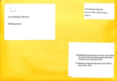
Archive - Gwen Mousley Collection - Plans for buildings, for St John's Deer Park - church hall & kindergarten,, 16/5/1951 & proposed toilet block for St John's, 9/7/74
... Folded plans 1) Blueprint + typed letter from Building Directorate, State of Victoria, 16 May 1951, issued to Church of England Trusts Corporation, Diocese of Melbourne, via Shire of Braybrook - building permit Church hall & kindergarten to be constructed of Mount Gambier limstone with an asbestos cement roof. 2) Plans on white paper re toilet block for St John's Church of England, Miles St, Deer Park prepared by B.& D. ...Kayser Folded plans 1) Blueprint + typed letter from Building Directorate, State of Victoria, 16 May 1951, issued to Church of England Trusts Corporation, Diocese of Melbourne, via Shire of Braybrook - building permit Church hall & kindergarten to be constructed of Mount Gambier limstone with an asbestos cement roof. 2) Plans on white paper re toilet block for St John's Church of England, Miles St, Deer Park prepared by B.& D. ...Signature of church wardens on 1951 blueprint: Chas F. Kennedy & S.A. Kayserst. johns church, deer park, miles street, church -
Surrey Hills Historical Society Collection
Document - Plans, Andrew Wood, Building plans associated with Andrew Wood, builder of Surrey Hills, 1920s
... .1: Specifications & plans for the kinder hall, Howard Street, Mont Albert for the Mont Albert Methodist Church, May 1925 .2 Plans for a proposed villa, 48 Payne's Paddock, Highfield Road, Canterbury for Mr E H Sillifant, dated 22/4/1920 .3 Plans for a timber villa for Mrs J A Burchell at Riversdale Road, Surrey Hills, stamped 9/5/1922 .4 Plan of a garage at Victoria avenue, Canterbury; stamped 14/2/1922 .5 Building permit & receipt from City of Hawthorn re Lot 16 Homebush Crescent; dated 7/4/1925 .6 Plans for a concrete house at Camberwell for Mr H W Field ...Andrew Wood builders Box Hill Cemetery kindergartens Mont Albert Methodist Church building plans Highfield Road Ernest Horatio Sillifant Victoria Avenue Canterbury Lot 16 Homebush Crescent Californian bungalows H W Field .1: Specifications & plans for the kinder hall, Howard Street, Mont Albert for the Mont Albert Methodist Church, May 1925 .2 Plans for a proposed villa, 48 Payne's Paddock, Highfield Road, Canterbury for Mr E H Sillifant, dated 22/4/1920 .3 Plans for a timber villa for Mrs J A Burchell at Riversdale Road, Surrey Hills, stamped 9/5/1922 .4 Plan of a garage at Victoria avenue, Canterbury; stamped 14/2/1922 .5 Building permit & receipt from City of Hawthorn re Lot 16 Homebush Crescent; dated 7/4/1925 .6 Plans for a concrete house at Camberwell for Mr H W Field Building plans associated with Andrew Wood, builder of Surrey Hills Document Plans Andrew Wood Robin Kelly Peter Bray ...These plans were associated with Mr Andrew Wood, a contract builder who worked in the 1920s and built many Californian bungalows in Surrey Hills and surrounding suburbs. Andrew Wood was born in Chiltern in 1861 to Andrew and Ellen Wood (MS: Green). His father had emigrated from Falkirk, Scotland. As a young man Andrew worked as a carpenter in the mines in South Africa (c 1899). He married Eleanor Agnes Stuchbery in Hamilton, Victoria in May 1901. They had 5 children - Doris (M Roberts), Robert Andrew, Donald Allen, Jean (M Cowan), and Gwenyth (M Bray). The first 2 children were born in Hawthorn; the other 3 in Surrey Hills. The family home at 286 Canterbury Road, Surrey Hills (on the corner of Middlesex Road) was built by Andrew. Andrew died in 1940; Eleanor died in 1977, aged 100 years. After Eleanor's death the house was sold and demolished. Surrey Lighting was established on the site. Gwenyth May Wood (3 May 1917, Surrey Hills - 5 Jan 2004) married Leslie David Charles Bray (1921-1983). Gwenyth was the donor's mother. Andrew, Eleanor and one son Robert are buried in Box Hill Cemetery - B-071-0028. .1: Specifications & plans for the kinder hall, Howard Street, Mont Albert for the Mont Albert Methodist Church, May 1925 .2 Plans for a proposed villa, 48 Payne's Paddock, Highfield Road, Canterbury for Mr E H Sillifant, dated 22/4/1920 .3 Plans for a timber villa for Mrs J A Burchell at Riversdale Road, Surrey Hills, stamped 9/5/1922 .4 Plan of a garage at Victoria avenue, Canterbury; stamped 14/2/1922 .5 Building permit & receipt from City of Hawthorn re Lot 16 Homebush Crescent; dated 7/4/1925 .6 Plans for a concrete house at Camberwell for Mr H W Field andrew wood, builders, box hill cemetery, kindergartens, mont albert methodist church, building plans, highfield road, ernest horatio sillifant, victoria avenue canterbury, lot 16 homebush crescent, californian bungalows, h w field -
Glen Eira Historical Society
Book - GLEN EIRA GUIDE
... It includes information about Council meetings, the names and contact details of the six members of the Council, information about services offered by the Glen Eira Service Centre, the contact details for particular services offered by the Glen Eira City Council, information about rates and valuations, information about the building permit application process, information about waste management, and federal and state electoral maps. ...It includes information about Council meetings, the names and contact details of the six members of the Council, information about services offered by the Glen Eira Service Centre, the contact details for particular services offered by the Glen Eira City Council, information about rates and valuations, information about the building permit application process, information about waste management, and federal and state electoral maps. ...This file contains one item: 1/A copy of the 1999 edition of the Glen Eira guide. This magazine aims to provide readers with useful information for living and working within the City of Glen Eira. It is divided into five principal sections. The first section, titled Glen Eira City Council Information, provides information pertaining to the local government. It includes information about Council meetings, the names and contact details of the six members of the Council, information about services offered by the Glen Eira Service Centre, the contact details for particular services offered by the Glen Eira City Council, information about rates and valuations, information about the building permit application process, information about waste management, and federal and state electoral maps. The second section, titled Council and Community Resource Guide, consists of a list of the various local community facilities and organizations. The third section, titled City of Glen Eira Safe Food Guide, consists of a list of food venues nominated by the Glen Eira City Council Environmental Health Services Department for their commendable level of hygiene. The fourth section, titled City of Glen Eira Business Development Unit, provides information about the eponymous local government department, which is aimed at providing aid to local businesses. The fifth and final section, titled ‘Think Local, BUY LOCAL’ Guide, consists of a list of local businesses, grouped according to industry, to try and encourage the support thereof.glen eira, city of glen eira, glen eira city council, local government, local officials and employees, kennedy norman cr, mayors, public utilities, community services, local government departments, rates, local government, building permits, waste disposal, community groups, cultural structures and establishments, law and order, libraries, education, educational and research establishments, religious groups, clubs and associations, community centres, food, restaurants, businesses -
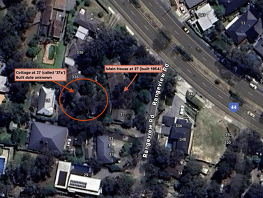 Eltham District Historical Society Inc
Document - Property Binder, 338 Main Road, Lower Plenty (also 37 Rangeview Road), March 2025
... for this studio was found in the Building Permit Register, Shire of Eltham, 1949-1960. ... for this studio was found in the Building Permit Register, Shire of Eltham, 1949-1960. ...EDHS_03095-338 | EDHS_08635-37 338 Main Road Lower Plenty | 37 Rangeview Road, Lower Plenty Original Mudbrick cottage and studio designed and built by Eltham artist, David Alan Newbury See also EDHS_06090 David Newbury (Artist) David Newbury was married to Clare Margaret Newbury. According to the 1954 Electoral Roll they were living at 36A Murphy Street, South Yarra however around 1953 they purchased Lots 3 and 4 of Main Road Lot Plan LP 23911 in Lower Plenty. A building permit, No. 71, was issued 8 December 1953 for a 5-room house of Vertical Board construction, cost £2,840, builder L. Williams, owner D. Newbury of 36 Murphy Cl., South Yarra. The large house was in fact mostly built of mudbrick, the construction method was only just becoming recognised as an acceptable form in the late 1940s for issuance of a building permit. The house was commenced in 1954, designed by David Newbury and built by David Newbury, Horrie Judd and others. Information from Newbury family friends suggests that a second mudbrick building was constructed in the late 1950s, early 1960s for use as an artist studio by Newbury. The building was connected directly to the water mains at the time and was made suitable for living accommodation during the period Newbury was teaching at Bendigo. Apparently he and Claire rented out the main house during their time in Bendigo and would reside in the studio when visiting Melbourne. No permit for this studio was found in the Building Permit Register, Shire of Eltham, 1949-1960. The last recorded entries in the register are dated May 1960. This would suggest that the studio was constructed post May 1960. It is believed the studio was constructed during the latter period of Newbury’s teaching post in Bendigo so possibly late 1960/1961. In 1963 the Newbury’s address in the Electoral Roll has the property recorded as 220 Main Road, Lower Plenty. Between 1967 to 1980 the Electoral Rolls record the property as 338 Main Road. Today the address is 37 Rangeview Road, Lower Plenty. Contents: 1. Extract from 1942 Shire of Eltham Rate Book. Muriel Gladys Reitsma listed as owner 2. Extract from 1984-85 Shire of Eltham Rate Book for Rangeview Road. (No mention of No. 37 so was probably still listed as 338 Main Road.) 3. Certificate of Title, Vol. 5601 Fol. 1120089 - Issued to David James Graham of Lower Plenty, Builder, Heidelberg for Lot 32 Block B on Plan of Subdivision No. 7606, part of Crown Portion Two, Parish of Nillumbik, County of Evelyn, 29 October 1929 4. Certificate of Title, Vol. 8008 Fol. 076 - Issued to David Alan Newbury of 36 Murphy Street, South Yarra, School Teacher for Lot 3 on Plan of Subdivision No. 23911, part of Crown Portion Two, Parish of Nillumbik, County of Evelyn, 29 October 1953. Amended 24 June 1963 to transfer portion for road widening scheme per Country Roads Board Plan 6889 - Cancelled 24 September 1984 5. Certificate of Title, Vol. 9581 Fol. 583 - Issued to Paul Robert Biber and Althea Constance Biber of 139 Lower Heidelberg Road, Ivanhoe for Lot 3 on Plan of Subdivision No. 23911, part of Crown Portion Two, Parish of Nillumbik, County of Evelyn, 24 September 1984. Derived from Vol. 8008 Fol. 076 L276994V - Cancelled 20 Nov 1992 when subdivided from one to two lots in Vol 10092 Fol. 192 and Vol. 10092 Fol. 193; LP222467B 6. Certificate of Title, Vol. 10092 Fol. 192 - Transfer to Lawrie Mein of 20 Dewar Drive, Hurstbridge of Lot 1 on Plan of Subdivision No. 222467B, lodged 17 Feb 1993, Registered 29 March 1996. Parent Titles Vol 08008 Fol 077, Vol 09581 Fol 583 7. Survey Field Notes of Part of Crown Portion 2, Parish of Nillumbik, County of Evelyn - Portion of land bounded by New Eltham Road. Application 23911 dated 8 Sep 1952 with appended Surveyor Field notes per Application 7098; R.D. Steele, Licensed Surveyor, 18 August 1950 8. Survey Field Notes of Part of Crown Portion 2, Parish of Nillumbik, County of Evelyn - Portion of land bounded by Main Road and Rangeview Road; 2 Lot subdivisions, Vol. 9581 Fol. 583 Part Lot 3 on LP 23911 and Vol. 8008 Fol, 077 Lot 4 on LP 23911; Application 221805 dated 27 November 1989; W.J. Goodison, Licensed Surveyor, and attached Surveyor's Report dated 6 June 1990 (Withdrawn) 9. Survey Field Notes of Part of Crown Portion 2, Parish of Nillumbik, County of Evelyn - Portion of land bounded by Main Road and Rangeview Road; 2 Lot subdivisions, Vol. 9581 Fol. 583 Part Lot 3 on LP 23911 and Vol. 8008 Fol, 077 Lot 4 on LP 23911; Application 222467 dated 20 November 1992 (221805 resubmitted); W.J. Goodison, Licensed Surveyor, and attached Surveyor's Report dated 6 June 1990 Notes: Items 1 to 6 donated electronically Items 7 to 9 sourced from LASSI - SPEAR, Department of Transport and Planning, Victoria State Government, https://maps.land.vic.gov.au/lassi/SpearUI.jsp main road, property, mudbrick, david newbury, phoebe mason collection, rate books, shire of eltham, certificate of title, survey plan, 37 rangeview road, 338 main road, application 23911, lower plenty, map, surveyor field notes, application 221805, application 222467 -
 Eltham District Historical Society Inc
Film - Video (VHS), Phil Burke et al, Shire of Eltham Grants Commsission Submission (Series 69, Item 7), 1993
... Shows scenes of assessing planning applications in these rural areas which takes significantly more time as well as other services provided such as Meals on Wheels, building permits, Ranger services. Provision of recreational facilities in hilly areas requires the acquisition of expensive river flats (views of cricket ground surrounded by hills) and where not possible, costly earthmoving required. ...Shows scenes of assessing planning applications in these rural areas which takes significantly more time as well as other services provided such as Meals on Wheels, building permits, Ranger services. Provision of recreational facilities in hilly areas requires the acquisition of expensive river flats (views of cricket ground surrounded by hills) and where not possible, costly earthmoving required. ...Shire of Eltham Archives: Series 69, Item 7 Opens with aerial views of the Shire, 85% of the shire covered by the Green wedge principal. Discusses the obligations required of the Shire to maintain the Green Wedge. The Shire covers over 27,000 hectares with a population in excess of 45,000 residents, more than 70% living in the southern 10% of the Shire in suburbs of Eltham, Montmorency, Lower Plenty and Research. 85% of the Shire in the more sparsely populated northern area which is covered by the Green Wedge. Council is committed to providing a parity of services to all residents such as garbage collection and maintenance of roads. Views of rubbish collection trucks in Montmorency. It is emphasised that the cost of these services in highly populated areas is relatively low whereas in the sparsely populated Green Wedge areas, considerable. There are hundreds of kilometres of roads throughout the Shire, many unmade and maintenance is high to check overhanging trees and erosion especially on the steep hills is expensive and disproportionate to servicing the population in the dense urban areas. Shows views of hilly gravel roads and graders at work maintaining them. Shows scenes of assessing planning applications in these rural areas which takes significantly more time as well as other services provided such as Meals on Wheels, building permits, Ranger services. Provision of recreational facilities in hilly areas requires the acquisition of expensive river flats (views of cricket ground surrounded by hills) and where not possible, costly earthmoving required. Also, views highlighting extensive tracks of natural habitat home to significant bird, animal and plant life. Shire emphasises its commitment highlighted by the Eltham Copper Butterfly which the Shire maintains small pockets of bushland to ensure its survival at significant expense (views of Pauline Toner Copper Butterfly Reserve.) Short interview with Pat Vaughan, Environmental Officer for the Shire discussing the Eltham Copper Butterfly who also mentions many other species in the Shire of high significance from bats to mammals to plants as well as the importance of the Green Wedge to Melbourne – the lungs of Melbourne - and ensuring the protection of very important habitat which requires a great deal of planning and management to look after. Views of Wingrove Park to emphasise this maintenance by machinery in some areas is too damaging and introduced species, etc must be removed by hand. Balancing the services and facilities expected by the community with the needs of the environment requires careful planning demands requires careful planning and the principals of the Green Wedge require constant attention in the face of growing need for housing. Director of Planning & Environment, Richard Allen advises there are approximately 1,300 planning permits and development applications each year ranging from simple subdivision, boundary realignments to further complicated non-urban developments for agricultural pursuits and the level of expertise required from architectural and engineering to land degradation, flora and fauna. Video finishes with aerial views and parklands, streetscapes and rural areas. VHS Video cassette Converted to MP4 file format 00:07:39; 89MBshire of eltham, video recording, shire of eltham archives, eltham shire council, eltham, building permits, cricket ground, development applications, eltham copper butterfly, garbage collection, graders, green wedge, lower plenty, meals on wheels, montmorency, pat vaughan, pauline toner reserve, planning applications, planning permits, ranger services, recreational facilities, research, richard allen, roads, rural areas, wingrove park, victoria grants commission -
 Sunshine and District Historical Society Incorporated
Archive - Sunshine Harvester Works H.V. McKay Massey Harris & Massey Ferguson - Miscelaneous Information
... Menhennitt 2693.15 - Russell Street Gates - Merv Brooks, John McIntyre & Roy Roberts 2693.16 - Massey Ferguson Historic Building Demolition Permit...Menhennitt 2693.15 - Russell Street Gates - Merv Brooks, John McIntyre & Roy Roberts 2693.16 - Massey Ferguson Historic Building Demolition Permit Collection of documents relating to the Sunshine Harvester Works H.V. ...2693.01 - H.V. McKay - D1197M Locking Plate Blue Print 2693.02 - H.V. McKay - FDR92 Side Delivery Chute Blue Print 2693.03 - H.V. McKay - Russell Street Gates 2693.04 - H.V. McKay - Sunshine Harvester Website Launch 2001 2693.05 - H.V. McKay Massey Harris - Bert Ustick's Retirement Function Invitation To Ed Jenkins 2693.06 - H.V. McKay Massey Hassey Massey Ferguson - Alec Galbraith 43 Years Of Service Complimentary Dinner Menu 2693.07 - Sunshine Harvester Works - Museum Of Victoria Website Information 2693.08 - Massey Ferguson Site - City Of Sunshine Stimulating Sunshine's Local Economy Council's Purchase Of Massey Ferguson Site 2693.09 - Sunshine Harvester Works - Newspaper Articles 2693.10 - Braybrook Implement Works Testimonials 2693.11 - H.V. McKay Memorial Scholarship 2693.12 - Sunshine Harvester Factory - A History Of Sunshine Harvester 2693.13 - H.V. McKay Satellite Horse Hoes Or Scufflers 2693.14 - H.V. McKay Machinery By E. E. Wegener & H. Menhennitt 2693.15 - Russell Street Gates - Merv Brooks, John McIntyre & Roy Roberts 2693.16 - Massey Ferguson Historic Building Demolition Permith.v. mckays massey ferguson, sunshine harvester works -
 Sunshine and District Historical Society Incorporated
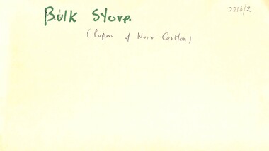
Archive - H.V McKay Bulk Store
... Newspaper Article Messenger 8 January 1998 titled Saved by change of heart|Newspaper Article The Advocate 29 July 1998 titled Eyesore or piece of history|Newspaper Article titled Bulk Store is meaningless Shirley A Strossa|Newspaper Article Advocate 22 July 1998 titled Bulk Store dissent|Petition Sunshine Harvester factory Buildings Form|Historic Building Act 1981 Permit 12470 Massey Ferguson Complex|Letter from Melbourne's Living Museum of the West Incorporated 5 January 1995 expressing objection to Mr Ray Tonkin Historic Buildings Council|Newspaper Article Sunshine Advocate 25 January 1995 titlled It's our heritage|Letter to Historic Buildings Council Hearing of Application 14 February 1995|Notes Submission to hearing of Historic Building Council on 14th February 1995|Notice informing public in 1995|Flyer titled Save Our Bulk Store Building|Flyer titled Why was saving the HV McKay Bulk Store|Flyer titled The Bulk Store must be saved|Written submissions on behalf of the applicant 12 April 1995|Newspaper Article Independent 25 April 1995 titled Demolition Bid|Historical Buildings Council 1994 to 1995 Annual Report|Newspaper Article Advocate 26 April 1995 titled Surprise Appeal Woolworths seeks nod to demolish buildings|Submission in the matter of the Historic Building Act 1981 and Burns Bridge Australia on behalf of Fabcot to demolish two brick buildings on the former Massey Ferguson site 12 April 1995|Letter to Historic Building Council 1 May 1995 S&DHS opposes the further application by Burns Bridge Australia for a permit to demolish two Sunshine Harvester Factory Building namely the bulk store and the electrical power house|Letter from Department of Planning and Development to Fabcot Pty Ltd 18 May 1995 regarding Massey Ferguson Complex Devonshire Road Sunshine encloses permit allowing the demoltition of the substation powerhouse building|Newspaper Article Brimbank Independent 23 May 1995 titled Compromise Breatkthrough for harvester site complex|Newspaper Article The Advocate 24 May 1995 titled Harvester building must be retained|Letter to Historic Buildings Council 24 August 1995 raising concerns|Newspaper Article The Times 30 August 1995 titled Woolworths unveils $70m Sunshine plan|Newspaper Article The Advocate 4 June 1997 titled Reaping the benefits|Letter to Heritage Victoria 23 September 1997 oppose Application from Amanda Johns of Minter Ellison for a permit to demolish the building|Letter from Melbourne's Living Museum of the West Incorporated 9 October 1997 expressing concern to S&DHS|Letter to Brimbank City Council 20th October 1997 S&DHS to draw certain matters to your attention|Newspaper Article The Advocate 29 October 1997 titled Renewed bid to Demolish Eyesore|Newspaper Article Brimbank Independent 4 November 1997 titled Fomer council blamed for McKay buildings disrepair The Sunshine factory was the birthplace of the basic award wage in Australia|Newspaper Article Brimbank Messenger 11 November 1997 titled Demolition threat on historic building|Newspaper Article Brimbank Independent 11 November 1997 titled Council waits for Heritage Victoria report before decision on Bulk Store threat|Newspaper Article The Age 13 November 1997 titled Past harvest of labor struggle and victory|Newspaper Article The Advocate 19 November 1997 titled Protecting our history|Letter from Adminstrative Appeals Tribunal 25 November 1997 advising hearing date|Letter to Adminstrative Appeals Tribunal 4 December 1997 Community & S&DHS objections to the demolition|Newspaper Article The Advocate 10 December 1997 titled Cinema Chaos|Newspaper Article The Age 15 December 1997 titled Rallying to maintain a little ray of Sunshine|Newspaper Article The Advocate 17 December 1997 titled Bulk Store Victory|Newspaper Article The Advocate 17 December 1997 titled McKay store fails to rate|Letter to Heritage Victoria from Beauchamp Consulting Engineers recommended repair method for the Former Massey Ferguson Bulk Store|Newspaper Article Brimbank Independent 17 February 1998 titled Bulk Store to be saved|Collection of documents of Gwen Goedecke regarding saving the Bulk Store|Advertising Melbourne's first 20 screen megaplex Village Cinemas|Blank Application to add building to the register of Historic buildings|Typed report from Beauchamp Consulting Engineers for Recommended Repair Method for Bulk Store|Typed report from Speroulla Christodoulou to Trades Hall Council regarding developer Woolworths want to demolish the Bulk Store building including all newspaper articles|Newspaper Article Brimbank Independent 26 January 1999 Funding Rejection for bulk store plans|Typed report The Story of How the Bulk Store was saved|Notice HV McKay Electrical Power House and Bulk Store|Typed report Why was saving the HV McKay Bulk Store so important?...McKays Sunshine Harvester Works Bulk Store Newspaper Article Messenger 8 January 1998 titled Saved by change of heart|Newspaper Article The Advocate 29 July 1998 titled Eyesore or piece of history|Newspaper Article titled Bulk Store is meaningless Shirley A Strossa|Newspaper Article Advocate 22 July 1998 titled Bulk Store dissent|Petition Sunshine Harvester factory Buildings Form|Historic Building Act 1981 Permit 12470 Massey Ferguson Complex|Letter from Melbourne's Living Museum of the West Incorporated 5 January 1995 expressing objection to Mr Ray Tonkin Historic Buildings Council|Newspaper Article Sunshine Advocate 25 January 1995 titlled It's our heritage|Letter to Historic Buildings Council Hearing of Application 14 February 1995|Notes Submission to hearing of Historic Building Council on 14th February 1995|Notice informing public in 1995|Flyer titled Save Our Bulk Store Building|Flyer titled Why was saving the HV McKay Bulk Store|Flyer titled The Bulk Store must be saved|Written submissions on behalf of the applicant 12 April 1995|Newspaper Article Independent 25 April 1995 titled Demolition Bid|Historical Buildings Council 1994 to 1995 Annual Report|Newspaper Article Advocate 26 April 1995 titled Surprise Appeal Woolworths seeks nod to demolish buildings|Submission in the matter of the Historic Building Act 1981 and Burns Bridge Australia on behalf of Fabcot to demolish two brick buildings on the former Massey Ferguson site 12 April 1995|Letter to Historic Building Council 1 May 1995 S&DHS opposes the further application by Burns Bridge Australia for a permit to demolish two Sunshine Harvester Factory Building namely the bulk store and the electrical power house|Letter from Department of Planning and Development to Fabcot Pty Ltd 18 May 1995 regarding Massey Ferguson Complex Devonshire Road Sunshine encloses permit allowing the demoltition of the substation powerhouse building|Newspaper Article Brimbank Independent 23 May 1995 titled Compromise Breatkthrough for harvester site complex|Newspaper Article The Advocate 24 May 1995 titled Harvester building must be retained|Letter to Historic Buildings Council 24 August 1995 raising concerns|Newspaper Article The Times 30 August 1995 titled Woolworths unveils $70m Sunshine plan|Newspaper Article The Advocate 4 June 1997 titled Reaping the benefits|Letter to Heritage Victoria 23 September 1997 oppose Application from Amanda Johns of Minter Ellison for a permit to demolish the building|Letter from Melbourne's Living Museum of the West Incorporated 9 October 1997 expressing concern to S&DHS|Letter to Brimbank City Council 20th October 1997 S&DHS to draw certain matters to your attention|Newspaper Article The Advocate 29 October 1997 titled Renewed bid to Demolish Eyesore|Newspaper Article Brimbank Independent 4 November 1997 titled Fomer council blamed for McKay buildings disrepair The Sunshine factory was the birthplace of the basic award wage in Australia|Newspaper Article Brimbank Messenger 11 November 1997 titled Demolition threat on historic building|Newspaper Article Brimbank Independent 11 November 1997 titled Council waits for Heritage Victoria report before decision on Bulk Store threat|Newspaper Article The Age 13 November 1997 titled Past harvest of labor struggle and victory|Newspaper Article The Advocate 19 November 1997 titled Protecting our history|Letter from Adminstrative Appeals Tribunal 25 November 1997 advising hearing date|Letter to Adminstrative Appeals Tribunal 4 December 1997 Community & S&DHS objections to the demolition|Newspaper Article The Advocate 10 December 1997 titled Cinema Chaos|Newspaper Article The Age 15 December 1997 titled Rallying to maintain a little ray of Sunshine|Newspaper Article The Advocate 17 December 1997 titled Bulk Store Victory|Newspaper Article The Advocate 17 December 1997 titled McKay store fails to rate|Letter to Heritage Victoria from Beauchamp Consulting Engineers recommended repair method for the Former Massey Ferguson Bulk Store|Newspaper Article Brimbank Independent 17 February 1998 titled Bulk Store to be saved|Collection of documents of Gwen Goedecke regarding saving the Bulk Store|Advertising Melbourne's first 20 screen megaplex Village Cinemas|Blank Application to add building to the register of Historic buildings|Typed report from Beauchamp Consulting Engineers for Recommended Repair Method for Bulk Store|Typed report from Speroulla Christodoulou to Trades Hall Council regarding developer Woolworths want to demolish the Bulk Store building including all newspaper articles|Newspaper Article Brimbank Independent 26 January 1999 Funding Rejection for bulk store plans|Typed report The Story of How the Bulk Store was saved|Notice HV McKay Electrical Power House and Bulk Store|Typed report Why was saving the HV McKay Bulk Store so important? ...Newspaper Article Messenger 8 January 1998 titled Saved by change of heart|Newspaper Article The Advocate 29 July 1998 titled Eyesore or piece of history|Newspaper Article titled Bulk Store is meaningless Shirley A Strossa|Newspaper Article Advocate 22 July 1998 titled Bulk Store dissent|Petition Sunshine Harvester factory Buildings Form|Historic Building Act 1981 Permit 12470 Massey Ferguson Complex|Letter from Melbourne's Living Museum of the West Incorporated 5 January 1995 expressing objection to Mr Ray Tonkin Historic Buildings Council|Newspaper Article Sunshine Advocate 25 January 1995 titlled It's our heritage|Letter to Historic Buildings Council Hearing of Application 14 February 1995|Notes Submission to hearing of Historic Building Council on 14th February 1995|Notice informing public in 1995|Flyer titled Save Our Bulk Store Building|Flyer titled Why was saving the HV McKay Bulk Store|Flyer titled The Bulk Store must be saved|Written submissions on behalf of the applicant 12 April 1995|Newspaper Article Independent 25 April 1995 titled Demolition Bid|Historical Buildings Council 1994 to 1995 Annual Report|Newspaper Article Advocate 26 April 1995 titled Surprise Appeal Woolworths seeks nod to demolish buildings|Submission in the matter of the Historic Building Act 1981 and Burns Bridge Australia on behalf of Fabcot to demolish two brick buildings on the former Massey Ferguson site 12 April 1995|Letter to Historic Building Council 1 May 1995 S&DHS opposes the further application by Burns Bridge Australia for a permit to demolish two Sunshine Harvester Factory Building namely the bulk store and the electrical power house|Letter from Department of Planning and Development to Fabcot Pty Ltd 18 May 1995 regarding Massey Ferguson Complex Devonshire Road Sunshine encloses permit allowing the demoltition of the substation powerhouse building|Newspaper Article Brimbank Independent 23 May 1995 titled Compromise Breatkthrough for harvester site complex|Newspaper Article The Advocate 24 May 1995 titled Harvester building must be retained|Letter to Historic Buildings Council 24 August 1995 raising concerns|Newspaper Article The Times 30 August 1995 titled Woolworths unveils $70m Sunshine plan|Newspaper Article The Advocate 4 June 1997 titled Reaping the benefits|Letter to Heritage Victoria 23 September 1997 oppose Application from Amanda Johns of Minter Ellison for a permit to demolish the building|Letter from Melbourne's Living Museum of the West Incorporated 9 October 1997 expressing concern to S&DHS|Letter to Brimbank City Council 20th October 1997 S&DHS to draw certain matters to your attention|Newspaper Article The Advocate 29 October 1997 titled Renewed bid to Demolish Eyesore|Newspaper Article Brimbank Independent 4 November 1997 titled Fomer council blamed for McKay buildings disrepair The Sunshine factory was the birthplace of the basic award wage in Australia|Newspaper Article Brimbank Messenger 11 November 1997 titled Demolition threat on historic building|Newspaper Article Brimbank Independent 11 November 1997 titled Council waits for Heritage Victoria report before decision on Bulk Store threat|Newspaper Article The Age 13 November 1997 titled Past harvest of labor struggle and victory|Newspaper Article The Advocate 19 November 1997 titled Protecting our history|Letter from Adminstrative Appeals Tribunal 25 November 1997 advising hearing date|Letter to Adminstrative Appeals Tribunal 4 December 1997 Community & S&DHS objections to the demolition|Newspaper Article The Advocate 10 December 1997 titled Cinema Chaos|Newspaper Article The Age 15 December 1997 titled Rallying to maintain a little ray of Sunshine|Newspaper Article The Advocate 17 December 1997 titled Bulk Store Victory|Newspaper Article The Advocate 17 December 1997 titled McKay store fails to rate|Letter to Heritage Victoria from Beauchamp Consulting Engineers recommended repair method for the Former Massey Ferguson Bulk Store|Newspaper Article Brimbank Independent 17 February 1998 titled Bulk Store to be saved|Collection of documents of Gwen Goedecke regarding saving the Bulk Store|Advertising Melbourne's first 20 screen megaplex Village Cinemas|Blank Application to add building to the register of Historic buildings|Typed report from Beauchamp Consulting Engineers for Recommended Repair Method for Bulk Store|Typed report from Speroulla Christodoulou to Trades Hall Council regarding developer Woolworths want to demolish the Bulk Store building including all newspaper articles|Newspaper Article Brimbank Independent 26 January 1999 Funding Rejection for bulk store plans|Typed report The Story of How the Bulk Store was saved|Notice HV McKay Electrical Power House and Bulk Store|Typed report Why was saving the HV McKay Bulk Store so important?|Letter to Brimbank City Council suggestion to use the Bulk Store as a youth centre|Letter to Norman Carlton at Sunshine and District Historical Society from Brimbank Council 8 September 2003|Letter from National Trust to Historical Buildings Council dated 5 March 1987|Report for submission in support of the Proposed demolition of Registered Historic Buildings for Former Bulk Store and Former Power Station Prepared for Burns Bridge Australia on behalf of Woolworths Pty Ltd|Letter to Heritage Victoria from Frank Ford dated 23 September 1997 pointing out structural reports and Brimbank Councils position and cultural significance of the Bulk Store Building|Handwritten Notes about Bulk Store 12 December 1997|Handwritten Notes about Bulk Store 15 December 1997|Handwritten Notes about Bulk Store 25 January 1998|Handwritten Notes about Bulk Store 29 January 1998|Various correspondence of City of Sunshine Councillors touring interstate for ideas of shopping mallsh.v. mckays, sunshine harvester works, bulk store -
 Bendigo Military Museum
Photograph - Continuous Indoor Cricket World Record Attempt, Seymour, Victoria, 1986
... The event was held at the Seymour Indoor Cricket Centre, an iron-roofed building with no air-conditioning, and all players had to battle the effect of the stifling heat in addition to fatigue. One player dropped out through exhaustion, but this did not prejudice the record attempt as the rules permitted each team to lose a player who cannot return to the game nor be replaced. ...The event was held at the Seymour Indoor Cricket Centre, an iron-roofed building with no air-conditioning, and all players had to battle the effect of the stifling heat in addition to fatigue. One player dropped out through exhaustion, but this did not prejudice the record attempt as the rules permitted each team to lose a player who cannot return to the game nor be replaced. ...This is a set of 12 photographs of Army teams from the Army Survey Regiment, Bendigo and the Army School of Transport, Puckapunyal attempting a world record playing indoor cricket, at Seymour Victoria from the 31st of January to the 5th of February 1986. The following article appeared on the back page of the ARMY Newspaper on Thursday 6th of March 1986. 'INDOOR CRICKET RECORD SMASHED. ARMY TEAMS from Puckapunyal and Bendigo recently played indoor cricket for 124 hours to set a new world record. The two eight-man teams, from Army School of Transport and Army Survey Regiment, broke the 120 hour record set by Corrimal High School, NSW earlier this year. Organiser of the event, Capt Marty Alsford of AST told ARMY the teams had played 107 games, scoring 15,000 runs in their chase for the record. "The rules allowed a five-minute rest break every hour which could be accrued, so we played for 64 hours straight then had a five hour sleep. "When everybody got up and went straight back into the game with no grumbling, I knew we had the record," Capt Alsford said. The event was held at the Seymour Indoor Cricket Centre, an iron-roofed building with no air-conditioning, and all players had to battle the effect of the stifling heat in addition to fatigue. One player dropped out through exhaustion, but this did not prejudice the record attempt as the rules permitted each team to lose a player who cannot return to the game nor be replaced. The Army teams' effort are now awaiting recognition by the Guinness Book of Records. During the marathon event, the soldiers raised money for Legacy, through sponsorships and a raffle. At the time ARMY went to press, the final figure was not available.’ Army Survey Regiment Routine Orders Part 1 Issue No 16/86 Notices on Page 7 stated: ‘World Record Indoor Cricket. 1. Congratulations to the following members for their successful attempt on the Guinness Book of Records, Record for continuous playing of indoor cricket: John Whaling, Peter Ball, Brenton McDonald, Per Andersen, John Anderson, Brian Fauth, Brett McAllister and Daryl South. 2. Our team, playing a team from Army School of Transport at Seymour played continuous Indoor Cricket for 124 hours, beating the existing record by 4 hours. During that time the two teams amassed a total in excess of 16,000 runs. 3. Congratulations also to Peter Ball for picking up the Trophy for the most outstanding player during the record attempt.’This is a set of 12 photographs of Army teams from Bendigo and Puckapunyal attempting a world record playing indoor cricket, at Seymour Victoria in February 1986. The photographs were printed on photographic paper and are part of the Army Survey Regiment’s Collection. The colour photographs were scanned at 300 dpi. .1) - Photo, colour, 1986, L to R: John ‘Junior’ Whaling, Marty Alsford. Background L to R: Peter Ball, unidentified, John ‘Flash’ Anderson. .2) - Photo, colour, 1986, L to R: John ‘Junior’ Whaling, unidentified, Peter Ball. .3) to .7) - Photo, colour, 1986, unidentified participants. .8) - Photo, colour, 1986, L to R: unidentified, Peter Ball, Brett McAllister, John ‘Junior’ Whaling. .9) - Photo, colour, 1986, L to R: unidentified, John ‘Flash’ Anderson, Brian Fauth, unidentified, Peter Ball, unidentified (x2). .10) - Photo, colour, 1986, Army School of Transport (red & white uniform) - back row L to R: unidentified (x4), front row L to R: unidentified (x3), Marty Alsford. Army Survey Regiment (dark green uniform) - back row L to R: Brett McAllister, John ‘Flash’ Anderson, Brian Fauth, Per Andersen, front row L to R: John ‘Junior’ Whaling, Daryl South, Brenton McDonald, Peter Ball. .11) & .12) - Photo, colour, 1986, Army Survey Regiment (dark green uniform) - back row L to R: Peter Ball, Per Andersen, Brett McAllister, Brian Fauth, front row L to R: Brenton McDonald, John ‘Flash’ Anderson, Daryl South, John ‘Junior’ Whaling..1P to .12P –No personnel are identified. ‘Attempt at World Record for Indoor Cricket 31 Jan - 5 Feb 1986’ annotated on cover sleeve.royal australian survey corps, rasvy, army survey regiment, army svy regt, fortuna -
 Kiewa Valley Historical Society
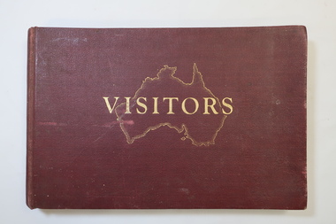
Visitors Book - Nissen Paradise, Welcome to our Nissen Paradise - Ski Nissen School - 1953 to 1960
... permits for private cars used by skiers with bookings in a Falls Creek lodge. The Nissen Ski Lodge was one of the early ski lodges at Falls Creek. Toni St Elmo Beveridge was involved in the early development of skiing at Falls Creek including assisting with the building of the early lodges, and establishing the Nissen Ski School. ...Nissen Lodge was built by 1953 at Falls Creek. The first lodge at Falls Creek was built in 1947 by SECV staff members. By the 1954 Ski Season, Falls Creek Alpine Village had 10 club lodges, plus a ski tow house and a commercial lodge that both provided skier accommodation. Several other club lodges were under construction. The Nissen Alpine Club operated a rope tow with a 240m rise in altitude..Ski lessons were also available. Re: Tony and Skippy St Elmo Beveridge See KVHS 1113 By 1953, the SECV was issuing entry permits for private cars used by skiers with bookings in a Falls Creek lodge.The Nissen Ski Lodge was one of the early ski lodges at Falls Creek. Toni St Elmo Beveridge was involved in the early development of skiing at Falls Creek including assisting with the building of the early lodges, and establishing the Nissen Ski School. See KVHS 1113. The book was later used for visiors to the KVHS museum located in the old Tawonga South School.Deep red, bound, thick cardboard book with gold outline of Australia and 'Visitors" on the centre front. Many pages each with a column for Date, Name in Full and Address in Full. Written in ink and pencil both sides of each page with the first date being 14 - 6 - 1953 to 17th September 1960. Entries follow from 1985 to 1994 when the closure of the display at the old South Tawonga Primary School is noted by the KVHS Secretary. The book also has 'Tony & Skippy St Elmo Beveridge' on its cover page. nissen ski lodge, visitors book falls creek, nissen school -
 Kiewa Valley Historical Society
Church Collection Receptacles, circa1900s
... permitted settlements that did not have a strong law enforcement section to prosper and develop without fear or "favour". The collection bag was, and is still, a physical endorsement of support towards the church and what it stands for. This was a time when it was a social requirement to be seen in the church building ...This church collection bag is quite unique in that it has three grip handles, not the usual two. Why three. It may represent the holy trinity of, the father,the son and the holy spirit. Historically this might be used to reinforce the holy trinity belief which at the time of this item's construction was under threat. The threat came from splinter Christian sects such as the Church Of Jesus Christ of the Latter-Day Saints which have a Godhead of a council of three deities and there are other christian religions of only one deity covering the father,the son and the holy spirit.This collection bag for offerings, was the main method available towards the upkeep of the church and its parish during this era. Broadcasting of religious services was not as prolific as in the late 1900s and into the 2000s. It was a time when visualisation of the support of religion(especially in rural ares) was an important social factor. The God "fearing" beliefs within society of this period, provided the strong moral fabric which permitted settlements that did not have a strong law enforcement section to prosper and develop without fear or "favour". The collection bag was, and is still, a physical endorsement of support towards the church and what it stands for. This was a time when it was a social requirement to be seen in the church building and supporting fellow parishioners. The ingrained Australian psyche of supporting anyone that needed help, was a result of this period.Church collection/donation bag. Simple construction of two round frames with three opposing handles nailed together to hold firm a small dark blue cloth pocket/bag. All fastened by nails to the handle/frame and the large pocket allows for a reasonable amount of coin or notes to be offered.religion, collection receptacles, christian offerings, church protocols -
 Kiewa Valley Historical Society
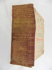
Book - Reference Melbourne Directory, Melbourne and Suburban Directory for 1889, Circa 1889
... Increased populations and greater levels of communication and safe fast transport facilities permitted greater devolution of commercial enterprises into rural communities, such as the Kiewa Valley. state government listings names and location of early melbourne population business names 1889 members of the victorian executive council On the spine in gold colour "South * British insurance Company Fire and Marine. Risks Lowest Current Rates No. 11 Queen Street, Arthur J Masters, Manager" and half way down " *Phoenix* Fire Office of London established over 100 years Annual Income exceeds (pound sign) 1,000,000" underneath "Losses Paid Over (pound sign) 16,000,000" underneath "Reserve Fund Exceeds (pound sign) 1,000,000" underneath "9 Market Buildings William Street, Melbourne " underneath " R. ...This Directory of 1889 covers the location of Melbourne based trade and professional offices by street and in Alphabetical order. It covers all of Melbourne and its suburbs. It also covers government and official, ecclesiastic, legal, municipal and miscellaneous information. The directory details a cross section of a developing city with a splattering of advertisements opening up an in depth look of all aspects of living in the late 1800s. It is interesting to see that all the advertisements do not have any telecommunication numbers listed (personal shoppers or mail orders only). This was a period of high moral standing within the community and hotels advertised rooms " suites of rooms for families and single rooms for Ladies and Gentlemen" also "electric bells throughout the house. Telephone, night porter and hot and cold baths."This directory would be used by the majority of families and businesses working and living within the Kiewa Valley and the surrounding area. Melbourne was the only place where every aspect of living requirement was catered for. Although the delivery of services and goods were not at a high rate, certain items or transactions would require a visit to "the big smoke". Business information are listed both by suburb and alphabetically. There is also a section for British and Foreign Trade. This directory covered nearly everything to do with commerce, an example pay days for principle firms. Greater evolution of trade locations started to balloon out after the mid 1950's. Increased populations and greater levels of communication and safe fast transport facilities permitted greater devolution of commercial enterprises into rural communities, such as the Kiewa Valley.This directory has no front or back cover and is held together by its cloth spine. It contains over 1300 pages, however there may be some pages missing front and back of the directory which would have contained advertisements of some unknown shops. All the sides of this directory (except the spine) have advertisements and content information stamped on. The spine cover has been placed in the directory until further conservation work is carried out. It has gold coloured printing and in the central section, a gold coloured background with the words "Sands & McDougall's Melbourne Directory 1889." The spine has three adverts on the spine.On the spine in gold colour "South * British insurance Company Fire and Marine. Risks Lowest Current Rates No. 11 Queen Street, Arthur J Masters, Manager" and half way down " *Phoenix* Fire Office of London established over 100 years Annual Income exceeds (pound sign) 1,000,000" underneath "Losses Paid Over (pound sign) 16,000,000" underneath "Reserve Fund Exceeds (pound sign) 1,000,000" underneath "9 Market Buildings William Street, Melbourne " underneath " R. Manfield Taylor, Agent" and at the bottom section" Henry Scott Auctioneer and Estate Agent 49 Bridport St., Albert Park" stamped on the bottom side across the page endings "The Wonderful Wertheim Sewing Machines Swanston Street opposite Town Hall", stamped on the top side across the page endings " The Sweet Hapsburg Pianos & Organs Swanston Street Opposite Town Hall"state government listings, names and location of early melbourne population business names, 1889 members of the victorian executive council -
 Bendigo Military Museum
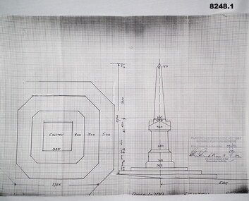
Plan - MONUMENT PLANS, 9.7.1992
... Refer Cat No 8245.2 brsl smirsl plans monument On all three written and stamped, " Planning and Environment Act 1987 Bendigo Planning scheme - Plan refrred to in Permit No 096/92 - Application No 096 (signature) 9.7.92 - for and on behalf of the responsible authority" .1) Plan, white paper, black print on black graph paper showing front elevation and plan of a monument, signed, dated and stamped. .2) Plan, white paper black print showing plan and section A.A of same structure as .1). .3) Plan, white paper black print showing position of proposed monument as in .1) in front of a building with gardens surrounding. signed, dated and stamped. ...All three pertain to the erection of a Monument in front of the Soldiers Memorial Institute in Pall Mall Bendigo to honour Ex Servicemen and Women. Refer Cat No 8245.2.1) Plan, white paper, black print on black graph paper showing front elevation and plan of a monument, signed, dated and stamped. .2) Plan, white paper black print showing plan and section A.A of same structure as .1). .3) Plan, white paper black print showing position of proposed monument as in .1) in front of a building with gardens surrounding. signed, dated and stamped.On all three written and stamped, " Planning and Environment Act 1987 Bendigo Planning scheme - Plan refrred to in Permit No 096/92 - Application No 096 (signature) 9.7.92 - for and on behalf of the responsible authority"brsl, smirsl, plans, monument -
 Bendigo Military Museum
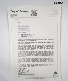
Document - APPROVAL FOR MONUMENT, Bendigo City Council, 9.7.1992
... The permits relate to the Building of a Monument at the front of the Soldiers Memorial Institute Pall Mall Bendigo now known as the Bendigo Military Museum. ...Bendigo Military Museum 37 - 39 Pall Mall Bendigo goldfields The permits relate to the Building of a Monument at the front of the Soldiers Memorial Institute Pall Mall Bendigo now known as the Bendigo Military Museum. ...The permits relate to the Building of a Monument at the front of the Soldiers Memorial Institute Pall Mall Bendigo now known as the Bendigo Military Museum. Refer Cat No 8245.2.1) Document, white paper black print, blue pen hand written relating to permission to erect a Monument at the Soldiers Memorial Institute. .2) Document, white paper black print relating to the permit for .1) re the conditions applying to. Both items signed by C.C. Campbell Director Engineering and Technical Services..1) In blue pen, "RSL Bendigo Memorial Hall Pall Mall Bendigo - permit N0 - 096/92 - 39 Pall Mall - Statue" .2) "9.7.92 - C Campbell"brsl, smirsl, monument, documents, permit, -
4th/19th Prince of Wales's Light Horse Regiment Unit History Room
Poem, The Horses Stay Behind, 1919
... Building 78 Simpson Barracks Macleod melbourne During WW1 Australia sent 39,348 Walers overseas to the AIF. Many Light Horsemen enlisted with their horses with a government promise that they would be able to bring their horses home with them. On the outbreak of peace, costs became important and it was deemed too costly to have horses repatriated to Australia - except for one horse, "Sandy", owned by General W T Bridges who died at Gallipoli in 1915 Quarantine was offered as a reason for not permitting the walers to return to Australia. ...During WW1 Australia sent 39,348 Walers overseas to the AIF. Many Light Horsemen enlisted with their horses with a government promise that they would be able to bring their horses home with them. On the outbreak of peace, costs became important and it was deemed too costly to have horses repatriated to Australia - except for one horse, "Sandy", owned by General W T Bridges who died at Gallipoli in 1915 Quarantine was offered as a reason for not permitting the walers to return to Australia. However, the horses would have had a long sea voyage, giving time for problems to emerge. Many of the fit horses were sold to the Indian ArmyFramed print of poem "The Horses Stay behind". In days to come we'll wander west and cross the range again; We'll hear the bush birds singing in the green trees after rain; We'll canter through the Mitchell grass and breast the bracing wind: But we'll have other horses. Our chargers stay behind. Around the fire at night we'll yarn about old Sinai; We'll fight our battles o'er again; and as the days go by There'll be old mates to greet us. The bush girls will be kind. Still our thoughts will often wander to the horses left. I don't think I could stand the thought of my old fancy hack Just crawling round old Cairo with a Gyppo on his back. Perhaps some English tourist out in Palestine may find My broken-hearted waler with a wooden plough behind. No; I'd better shoot him and tell a little lie: "He floundered in a wombat hole and then lay down to die" May be I'll be court-martialled; but I'm damned if I'm inclined To go back to Australia and leave my horse behind. Trooper Bluegum -
 Eltham District Historical Society Inc
Photograph - Aerial Photograph, Landata, Eltham; Crown Allotment 15, Section 5, Parish of Nillumbik (Stokes Orchard Estate), Dec. 1945
... In February 1945 Stokes applied for a permit to build a “packing shed” as no house building was allowed. ...In February 1945 Stokes applied for a permit to build a “packing shed” as no house building was allowed. ...Centred on present day Diosma Rd, Stokes Pl, Nyora Rd and Eucalyptus Rd Historic Aerial Imagery Source: Landata.vic.gov.au Aerial Photo Details: Project No :5 Project : MELBOURNE AND METROPOLITAN AREA PROJECT Run : 36 Frame : 60546 Date : 12/1945 Film Type : B/W Camera : EAG4 Flying Height : 10200 Scale : 6000 Film Number : 195 GDA2020 : 37°42'47"S, 145°09'56"E MGA2020 : 338306, 5824438 (55) Melways : 22 C4 (ed. 42) A History of the Development of Crown Allotment 15, Section 5, Parish of Nillumbik – Stokes Orchard Crown Allotment 15, Section 5, Parish of Nillumbik (CA15) is a square allotment of 158 acres or approximately a quarter of a square mile. It lies just beyond the eastern end of Pitt Street, south of Nyora Road to the northern end of Eucalyptus Road and extends east from Eucalyptus Road to Reynolds Road. The topography of CA15 is generally steep, sloping up to a hill near the centre of the land, the ridgeline passing through the properties along the southern side of Diosma Road. Eucalyptus Road is a straight north-south road with its northern end at the north west corner of CA15. Until the end of the 1970s this road was an un-named Government Road and was largely not open to traffic. With residential development in the 1970s the road was constructed, and the council allocated the name obviously in recognition of the predominant species of the local bushland. CA15 was purchased from the Crown by George D’Arley Boursiquot, a prominent Melbourne printer, on 28th October 1852. On November 23, 1922, former Member for Gippsland and Melbourne Real Estate Agent, Hubert Patrick Keogh purchased the allotment then sold it March 13, 1925, to local farmer, Robert David Taylor, a former Shire of Eltham Councillor (1911-1920) and Shire President (1919). Taylor had extensive land holdings stretching west towards Bible Street and Main Road. The Taylor home was situated at the top of the hill in Bible Street at present day 82 Bible Street. At the time of Taylor’s purchase in 1925, CA15 was subdivided into 48 lots that could be described as small rural properties or large residential lots. A typical lot size was one hectare or 2.5 acres. The subdivision created two roads, Nyora Road, and Diosma Road, each following an irregular alignment between Eucalyptus and Reynolds Roads. However, the lots were not sold off separately nor were the roads constructed. The land effectively remained as one parcel for many further years. Robert David Taylor died November 30, 1934, and probate was granted to his son of the same name, Robert David Taylor of Bible Street, Salesman and William McLelland Vance Taylor of 73 Emmeline Street, Northcote, Clerk, with the transfer of the land into their names on July 8, 1935. Frank Stokes worked as a qualified accountant at Kennons leather factory in Burnley, while living at 1 Thomas Street, Mitcham. He suffered from migraines and wanted to return to working the land (he had previously worked on farms and orchards since coming to Australia from England in 1926, both in WA and Vic.). He first travelled to the district by train in July 1942 to find land with the intention to establish an orchard. By chance he met Arthur Bird of Bird Orchard (bounded by Pitt Street, Eucalyptus Road, and Wattle Grove) and they got talking over their common interest. Arthur put Frank up for the night and pointed out the land, 158 acres- part of the Taylor Estate- £900, Crown Allotment 15, Section 5, Parish of Nillumbik (CA15) somewhat diagonally opposite Bird Orchard. Stokes applied through the Riverina Agency to purchase the land who in turn applied for permission from Canberra to sell as there was a new government regulation introduced during the Second World War banning land sales except for immediate production. Stokes obtained a loan on his Mitcham house of £600 @ 5% and paid £450 deposit with quarterly payments of £15 spread over 5 years. Stokes was assisted and advised by Arthur Bird who farmed the neighbouring orchard. In early 1943 Stokes took possession and would catch the train out to Eltham on Fridays after work and began building a hut on the corner of Nyora Road and the Government Road (Eucalyptus Road) for shelter and to lock up tools. He established an orchard on the central western part of the land through the centre of which ran a natural waterway (part of the present-day linear park) and was able to pay a neighbour (Hawkins) to help with clearing and fencing 25 acres, and with a horse and single furrowed plough, planted approximately 2,500 fruit trees - cherries, peaches, plums, almonds, pears, apricots and lemons as well as a few apples and oranges; a massive task. Aerial photographs from the 1940s through to the 1990s clearly show the orchard with most of the larger CA15 site remaining as natural bushland. A huge problem was hares and rabbits eating all the new buds off the tiny trees. As well as laying poison he painted the trees with a mixture of cow manure and lime, often working by moonlight. Procurement of wire and wire netting was difficult because of the war but after much effort he obtained a permit from the Agricultural Department for supplies in March 1944. In February 1945 Stokes applied for a permit to build a “packing shed” as no house building was allowed. It was to be 33 feet x 21 feet and cost £312. It was constructed mostly from second-hand materials, which were hard to obtain, especially iron for roofing. Stokes finished work at Kennons on October 31, 1945, and in March 1946 he sold the family home at Mitcham for £1,230 plus £170 for furniture. On May 15, 1946, title to the CA15 property was issued to Frank Howard Alfred Stokes, Orchardist and Gladys Ethel Stokes, Married Woman, both of Pitt Street, Eltham. The family of five then moved into the very unfinished “packing shed” at Eltham, which was a struggle to weatherproof. Eventually rooms were divided off and lined with hessian bags and whitewashed. Their income was firewood (cut and sold), selling rockery stones and cut Sweet Bursaria. (It was discovered during the 1940s that Sweet Bursaria contained the sunscreen compound Aesculin. The RAAF utilised this compound from Sweet Bursaria during WW2 for pilots and gunners.) The orchard’s first fruit sale was a half-case of Le Vanq peaches in December 1947 for the price of 8 shillings. In 1956 plans for house were drawn and Glen Iris bricks purchased (1956 Olympic Rings variant). The building of the house commenced in 1957 - 12 feet of original packing shed was removed – and was completed in 1959. Water was connected from newly built pressure storage on the property at the end of 1959 and the electricity connection for the first time at 3pm on April 29, 1960. The house remains to present day (somewhat modified) at 1 Nyora Road, home to Nyora Studio Gallery. On occasions, spare remnants of the 1956 bricks have been known to be unearthed in gardens on the estate as they were utilised by Frank Stokes to fill in rabbit holes. On May 26, 1950, a parcel of land was compulsorily acquired by the Melbourne and Metropolitan Board of Works on the hilltop to establish an easement for a high-level service reservoir to augment Eltham’s water supply. The project also included pipe tracks for the necessary water mains. The reservoir has now been superseded by higher level water tanks east of Reynolds Road and its former site is now a public reserve. On November 27, 1964, the State Electricity Commission served notice to compulsorily acquire a further parcel through the eastern part of the land for a major electricity transmission line that augmented supply from the La Trobe Valley to Melbourne. The easement was registered February 11, 1966. The easement was widened July 18, 1969 for a second transmission line to be constructed. In 1971 Melbourne Metropolitan Planning Scheme amendments adopted Nyora Road as the boundary between a residential zone to the north and a rural zone to the south. This determined the future development of the land. In the mid-1970s the Shire of Eltham divided the orchard into numerous rate-able parcel lots, the 48 lots having been established in 1925 and the subsequent rates assessment proved unsustainable for Stokes. He commenced selling lots outside the boundary of the orchard, north of Diosma and South of Nyora. However shortly later the land between Nyora and Diosma Roads and west of the electricity easement was sold and subdivided into residential lots, a housing development by Macquarie Builders and marketed as the Stokes Orchard Estate. New streets were created, and most were named after trees, although one, Stokes Place, commemorates the former owners. The development was undertaken in two stages; Stage 1 (1975) encompassing Scarlet Ash Court, Ironbark Close and Peppermint Grove bounded by Nyora and Eucalyptus roads and Stage 2 (1978) encompassing Stokes Place, Orchard Way, The Crest and The Lookout bound by Nyora and Diosma roads. The developer, Macquarie Builders went bankrupt shortly after the release of Stage 2 leaving many purchasers to fend for themselves and arrange for their own independent builders. There were also difficulties with sewerage for the land immediately south of Diosma Road and so the conventional residential lots were abandoned in favour of larger lots. The development of Orchard Way, The Crest and The Lookout did not proceed as planned and the proposed lots were incorporated into five-acre parcels instead. These included a low-density group housing development by the Graves family and the award winning Choong House (1983) with Gordon Ford developed garden immediately next door situated on the ridge of the hill nestled amongst the original bush, Eucalypt trees and Sweet Bursaria. In 1994, Nillumbik Shire Council applied Significant Environment and Significant Landscape overlays upon the properties on the south side of Diosma Road to ensure protection of this natural bush garden environment. With the arrival of the sewer along Diosma Road in the 1990s, most of these five-acre parcels have since been subdivided multiple times. The Choong house presently sits on a 2.7-acre property, which in 2022 Nillumbik Council nominated for Cultural Significance Heritage protection and is considered potentially significant at State level. The Stokes family were also associated with the Eltham Christian Church. In the 1970s this church had met in temporary premises in Eltham. Lots of the original 1925 subdivision remained south of Nyora Road and a number of these lots were utilized for the Eltham Christian School, which was established by the Eltham Christian Church in 1981. The school operated on this site until 2000. The premises are now used by The Vine Baptist Church. By the mid-1980s the whole of CA15 had been developed for residential and school purposes, except for the sections north of Diosma Road and between the transmission lines and Reynolds Road. Sewerage issues had been resolved for the section north of Diosma Road and in 1987 it was in the process of being subdivided into residential lots. The development coincided with the discovery of colonies of the rare and endangered Eltham Copper Butterfly on the site. This resulted in a community and political campaign to save the butterfly habitat. With the co-operation of the land developer the subdivision was altered to create two bushland reserves in the critical butterfly habitat areas. In the late 1980s the State Government was investigating options for establishing a metropolitan ring road link between Diamond Creek and Ringwood. The chosen route was adjacent to Reynolds Road and so this created a freeze on development of CA15 between Reynolds Road and the electricity easement. The ring road proposal was eventually abandoned, and this part of the land was subdivided into low density residential lots. Diosma Road has been discontinued at the electricity easement and the eastern part incorporated into View Mount Court with access from Reynolds Road. The whole of CA15 has now been developed for residential or associated purposes, ranging from conventional density to quite low density south of Nyora Road. Some remnants of the orchard remain, a few cherry trees on the Graves property and a lone apple tree in Stokes Place. The butterfly reserves comprise significant areas of remnant bushland. Linear reserves through the estate link with central Eltham via the Woodridge linear reserve and with Research along the electricity easement. CA15 as it exists today has a complicated history of rural use, Government acquisition, urban development, and community action. References: • “Stokes Orchard, an incomplete history”; Russell Yeoman with Doug Orford • Correspondence, Beryl Bradbury (nee Stokes) • Aerial Photographs, 1931-1991, Landata (landata.vic.gov.au) • Certificate of Title, Vol. 4930 Fol. 985900 • Plan Number LP 10859 aerial photo, diosma road, eltham copper butterfly, eucalyptus road, ironbark close, nyora road, peppermint grove, peter & elizabeth pidgeon collection, power transmission lines, reynolds road, scarlet ash court, stokes orchard estate, stokes place, woodridge estate, frank stokes -
 Eltham District Historical Society Inc
Photograph - Aerial Photograph, Landata, Eltham; Crown Allotment 15, Section 5, Parish of Nillumbik (Stokes Orchard Estate), Nov. 1931
... In February 1945 Stokes applied for a permit to build a “packing shed” as no house building was allowed. ...In February 1945 Stokes applied for a permit to build a “packing shed” as no house building was allowed. ...Centred over present day Reynolds Road and Mount Pleasant Road, Eltham (including Diosma Rd, Stokes Pl, Nyora Rd and Eucalyptus Rd) Historic Aerial Imagery Source: Landata.vic.gov.au Aerial Photo Details: Project No :1931 Project : MALDON PRISON Run : 21 Frame : 3160 Date : 11/1931 Film Type : B/W Camera : F8 Flying Height : 11000 Scale : 18860 Film Number : 60 GDA2020 : 37°43'31"S, 145°10'20"E MGA2020 : 338912, 5823086 (55) Melways : 22 E8 (ed. 42) A History of the Development of Crown Allotment 15, Section 5, Parish of Nillumbik – Stokes Orchard Crown Allotment 15, Section 5, Parish of Nillumbik (CA15) is a square allotment of 158 acres or approximately a quarter of a square mile. It lies just beyond the eastern end of Pitt Street, south of Nyora Road to the northern end of Eucalyptus Road and extends east from Eucalyptus Road to Reynolds Road. The topography of CA15 is generally steep, sloping up to a hill near the centre of the land, the ridgeline passing through the properties along the southern side of Diosma Road. Eucalyptus Road is a straight north-south road with its northern end at the north west corner of CA15. Until the end of the 1970s this road was an un-named Government Road and was largely not open to traffic. With residential development in the 1970s the road was constructed, and the council allocated the name obviously in recognition of the predominant species of the local bushland. CA15 was purchased from the Crown by George D’Arley Boursiquot, a prominent Melbourne printer, on 28th October 1852. On November 23, 1922, former Member for Gippsland and Melbourne Real Estate Agent, Hubert Patrick Keogh purchased the allotment then sold it March 13, 1925, to local farmer, Robert David Taylor, a former Shire of Eltham Councillor (1911-1920) and Shire President (1919). Taylor had extensive land holdings stretching west towards Bible Street and Main Road. The Taylor home was situated at the top of the hill in Bible Street at present day 82 Bible Street. At the time of Taylor’s purchase in 1925, CA15 was subdivided into 48 lots that could be described as small rural properties or large residential lots. A typical lot size was one hectare or 2.5 acres. The subdivision created two roads, Nyora Road, and Diosma Road, each following an irregular alignment between Eucalyptus and Reynolds Roads. However, the lots were not sold off separately nor were the roads constructed. The land effectively remained as one parcel for many further years. Robert David Taylor died November 30, 1934, and probate was granted to his son of the same name, Robert David Taylor of Bible Street, Salesman and William McLelland Vance Taylor of 73 Emmeline Street, Northcote, Clerk, with the transfer of the land into their names on July 8, 1935. Frank Stokes worked as a qualified accountant at Kennons leather factory in Burnley, while living at 1 Thomas Street, Mitcham. He suffered from migraines and wanted to return to working the land (he had previously worked on farms and orchards since coming to Australia from England in 1926, both in WA and Vic.). He first travelled to the district by train in July 1942 to find land with the intention to establish an orchard. By chance he met Arthur Bird of Bird Orchard (bounded by Pitt Street, Eucalyptus Road, and Wattle Grove) and they got talking over their common interest. Arthur put Frank up for the night and pointed out the land, 158 acres- part of the Taylor Estate- £900, Crown Allotment 15, Section 5, Parish of Nillumbik (CA15) somewhat diagonally opposite Bird Orchard. Stokes applied through the Riverina Agency to purchase the land who in turn applied for permission from Canberra to sell as there was a new government regulation introduced during the Second World War banning land sales except for immediate production. Stokes obtained a loan on his Mitcham house of £600 @ 5% and paid £450 deposit with quarterly payments of £15 spread over 5 years. Stokes was assisted and advised by Arthur Bird who farmed the neighbouring orchard. In early 1943 Stokes took possession and would catch the train out to Eltham on Fridays after work and began building a hut on the corner of Nyora Road and the Government Road (Eucalyptus Road) for shelter and to lock up tools. He established an orchard on the central western part of the land through the centre of which ran a natural waterway (part of the present-day linear park) and was able to pay a neighbour (Hawkins) to help with clearing and fencing 25 acres, and with a horse and single furrowed plough, planted approximately 2,500 fruit trees - cherries, peaches, plums, almonds, pears, apricots and lemons as well as a few apples and oranges; a massive task. Aerial photographs from the 1940s through to the 1990s clearly show the orchard with most of the larger CA15 site remaining as natural bushland. A huge problem was hares and rabbits eating all the new buds off the tiny trees. As well as laying poison he painted the trees with a mixture of cow manure and lime, often working by moonlight. Procurement of wire and wire netting was difficult because of the war but after much effort he obtained a permit from the Agricultural Department for supplies in March 1944. In February 1945 Stokes applied for a permit to build a “packing shed” as no house building was allowed. It was to be 33 feet x 21 feet and cost £312. It was constructed mostly from second-hand materials, which were hard to obtain, especially iron for roofing. Stokes finished work at Kennons on October 31, 1945, and in March 1946 he sold the family home at Mitcham for £1,230 plus £170 for furniture. On May 15, 1946, title to the CA15 property was issued to Frank Howard Alfred Stokes, Orchardist and Gladys Ethel Stokes, Married Woman, both of Pitt Street, Eltham. The family of five then moved into the very unfinished “packing shed” at Eltham, which was a struggle to weatherproof. Eventually rooms were divided off and lined with hessian bags and whitewashed. Their income was firewood (cut and sold), selling rockery stones and cut Sweet Bursaria. (It was discovered during the 1940s that Sweet Bursaria contained the sunscreen compound Aesculin. The RAAF utilised this compound from Sweet Bursaria during WW2 for pilots and gunners.) The orchard’s first fruit sale was a half-case of Le Vanq peaches in December 1947 for the price of 8 shillings. In 1956 plans for house were drawn and Glen Iris bricks purchased (1956 Olympic Rings variant). The building of the house commenced in 1957 - 12 feet of original packing shed was removed – and was completed in 1959. Water was connected from newly built pressure storage on the property at the end of 1959 and the electricity connection for the first time at 3pm on April 29, 1960. The house remains to present day (somewhat modified) at 1 Nyora Road, home to Nyora Studio Gallery. On occasions, spare remnants of the 1956 bricks have been known to be unearthed in gardens on the estate as they were utilised by Frank Stokes to fill in rabbit holes. On May 26, 1950, a parcel of land was compulsorily acquired by the Melbourne and Metropolitan Board of Works on the hilltop to establish an easement for a high-level service reservoir to augment Eltham’s water supply. The project also included pipe tracks for the necessary water mains. The reservoir has now been superseded by higher level water tanks east of Reynolds Road and its former site is now a public reserve. On November 27, 1964, the State Electricity Commission served notice to compulsorily acquire a further parcel through the eastern part of the land for a major electricity transmission line that augmented supply from the La Trobe Valley to Melbourne. The easement was registered February 11, 1966. The easement was widened July 18, 1969 for a second transmission line to be constructed. In 1971 Melbourne Metropolitan Planning Scheme amendments adopted Nyora Road as the boundary between a residential zone to the north and a rural zone to the south. This determined the future development of the land. In the mid-1970s the Shire of Eltham divided the orchard into numerous rate-able parcel lots, the 48 lots having been established in 1925 and the subsequent rates assessment proved unsustainable for Stokes. He commenced selling lots outside the boundary of the orchard, north of Diosma and South of Nyora. However shortly later the land between Nyora and Diosma Roads and west of the electricity easement was sold and subdivided into residential lots, a housing development by Macquarie Builders and marketed as the Stokes Orchard Estate. New streets were created, and most were named after trees, although one, Stokes Place, commemorates the former owners. The development was undertaken in two stages; Stage 1 (1975) encompassing Scarlet Ash Court, Ironbark Close and Peppermint Grove bounded by Nyora and Eucalyptus roads and Stage 2 (1978) encompassing Stokes Place, Orchard Way, The Crest and The Lookout bound by Nyora and Diosma roads. The developer, Macquarie Builders went bankrupt shortly after the release of Stage 2 leaving many purchasers to fend for themselves and arrange for their own independent builders. There were also difficulties with sewerage for the land immediately south of Diosma Road and so the conventional residential lots were abandoned in favour of larger lots. The development of Orchard Way, The Crest and The Lookout did not proceed as planned and the proposed lots were incorporated into five-acre parcels instead. These included a low-density group housing development by the Graves family and the award winning Choong House (1983) with Gordon Ford developed garden immediately next door situated on the ridge of the hill nestled amongst the original bush, Eucalypt trees and Sweet Bursaria. In 1994, Nillumbik Shire Council applied Significant Environment and Significant Landscape overlays upon the properties on the south side of Diosma Road to ensure protection of this natural bush garden environment. With the arrival of the sewer along Diosma Road in the 1990s, most of these five-acre parcels have since been subdivided multiple times. The Choong house presently sits on a 2.7-acre property, which in 2022 Nillumbik Council nominated for Cultural Significance Heritage protection and is considered potentially significant at State level. The Stokes family were also associated with the Eltham Christian Church. In the 1970s this church had met in temporary premises in Eltham. Lots of the original 1925 subdivision remained south of Nyora Road and a number of these lots were utilized for the Eltham Christian School, which was established by the Eltham Christian Church in 1981. The school operated on this site until 2000. The premises are now used by The Vine Baptist Church. By the mid-1980s the whole of CA15 had been developed for residential and school purposes, except for the sections north of Diosma Road and between the transmission lines and Reynolds Road. Sewerage issues had been resolved for the section north of Diosma Road and in 1987 it was in the process of being subdivided into residential lots. The development coincided with the discovery of colonies of the rare and endangered Eltham Copper Butterfly on the site. This resulted in a community and political campaign to save the butterfly habitat. With the co-operation of the land developer the subdivision was altered to create two bushland reserves in the critical butterfly habitat areas. In the late 1980s the State Government was investigating options for establishing a metropolitan ring road link between Diamond Creek and Ringwood. The chosen route was adjacent to Reynolds Road and so this created a freeze on development of CA15 between Reynolds Road and the electricity easement. The ring road proposal was eventually abandoned, and this part of the land was subdivided into low density residential lots. Diosma Road has been discontinued at the electricity easement and the eastern part incorporated into View Mount Court with access from Reynolds Road. The whole of CA15 has now been developed for residential or associated purposes, ranging from conventional density to quite low density south of Nyora Road. Some remnants of the orchard remain, a few cherry trees on the Graves property and a lone apple tree in Stokes Place. The butterfly reserves comprise significant areas of remnant bushland. Linear reserves through the estate link with central Eltham via the Woodridge linear reserve and with Research along the electricity easement. CA15 as it exists today has a complicated history of rural use, Government acquisition, urban development, and community action. References: • “Stokes Orchard, an incomplete history”; Russell Yeoman with Doug Orford • Correspondence, Beryl Bradbury (nee Stokes) • Aerial Photographs, 1931-1991, Landata (landata.vic.gov.au) • Certificate of Title, Vol. 4930 Fol. 985900 • Plan Number LP 10859 aerial photo, diosma road, eltham copper butterfly, eucalyptus road, ironbark close, nyora road, peppermint grove, peter & elizabeth pidgeon collection, power transmission lines, reynolds road, scarlet ash court, stokes orchard estate, stokes place, woodridge estate, frank stokes -
 Eltham District Historical Society Inc
Photograph - Aerial Photograph, Landata, Eltham; Crown Allotment 15, Section 5, Parish of Nillumbik (Stokes Orchard Estate), Jan. 1951
... In February 1945 Stokes applied for a permit to build a “packing shed” as no house building was allowed. ...In February 1945 Stokes applied for a permit to build a “packing shed” as no house building was allowed. ...Centred on present day Diosma Rd, Stokes Pl, Nyora Rd and Eucalyptus Rd Historic Aerial Imagery Source: Landata.vic.gov.au Aerial Photo Details: Project No :65 Project : MELBOURNE AND METROPOLITAN PROJECT NO. 2 Run : 8 Frame : 71 Date : 01/1951 Film Type : B/W Camera : EAG9 Flying Height : 12200 Scale : 12000 Film Number : 1419 GDA2020 : 37°43'14"S, 145°09'46"E MGA2020 : 338081, 5823608 (55) Melways : 22 C6 (ed. 42) A History of the Development of Crown Allotment 15, Section 5, Parish of Nillumbik – Stokes Orchard Crown Allotment 15, Section 5, Parish of Nillumbik (CA15) is a square allotment of 158 acres or approximately a quarter of a square mile. It lies just beyond the eastern end of Pitt Street, south of Nyora Road to the northern end of Eucalyptus Road and extends east from Eucalyptus Road to Reynolds Road. The topography of CA15 is generally steep, sloping up to a hill near the centre of the land, the ridgeline passing through the properties along the southern side of Diosma Road. Eucalyptus Road is a straight north-south road with its northern end at the north west corner of CA15. Until the end of the 1970s this road was an un-named Government Road and was largely not open to traffic. With residential development in the 1970s the road was constructed, and the council allocated the name obviously in recognition of the predominant species of the local bushland. CA15 was purchased from the Crown by George D’Arley Boursiquot, a prominent Melbourne printer, on 28th October 1852. On November 23, 1922, former Member for Gippsland and Melbourne Real Estate Agent, Hubert Patrick Keogh purchased the allotment then sold it March 13, 1925, to local farmer, Robert David Taylor, a former Shire of Eltham Councillor (1911-1920) and Shire President (1919). Taylor had extensive land holdings stretching west towards Bible Street and Main Road. The Taylor home was situated at the top of the hill in Bible Street at present day 82 Bible Street. At the time of Taylor’s purchase in 1925, CA15 was subdivided into 48 lots that could be described as small rural properties or large residential lots. A typical lot size was one hectare or 2.5 acres. The subdivision created two roads, Nyora Road, and Diosma Road, each following an irregular alignment between Eucalyptus and Reynolds Roads. However, the lots were not sold off separately nor were the roads constructed. The land effectively remained as one parcel for many further years. Robert David Taylor died November 30, 1934, and probate was granted to his son of the same name, Robert David Taylor of Bible Street, Salesman and William McLelland Vance Taylor of 73 Emmeline Street, Northcote, Clerk, with the transfer of the land into their names on July 8, 1935. Frank Stokes worked as a qualified accountant at Kennons leather factory in Burnley, while living at 1 Thomas Street, Mitcham. He suffered from migraines and wanted to return to working the land (he had previously worked on farms and orchards since coming to Australia from England in 1926, both in WA and Vic.). He first travelled to the district by train in July 1942 to find land with the intention to establish an orchard. By chance he met Arthur Bird of Bird Orchard (bounded by Pitt Street, Eucalyptus Road, and Wattle Grove) and they got talking over their common interest. Arthur put Frank up for the night and pointed out the land, 158 acres- part of the Taylor Estate- £900, Crown Allotment 15, Section 5, Parish of Nillumbik (CA15) somewhat diagonally opposite Bird Orchard. Stokes applied through the Riverina Agency to purchase the land who in turn applied for permission from Canberra to sell as there was a new government regulation introduced during the Second World War banning land sales except for immediate production. Stokes obtained a loan on his Mitcham house of £600 @ 5% and paid £450 deposit with quarterly payments of £15 spread over 5 years. Stokes was assisted and advised by Arthur Bird who farmed the neighbouring orchard. In early 1943 Stokes took possession and would catch the train out to Eltham on Fridays after work and began building a hut on the corner of Nyora Road and the Government Road (Eucalyptus Road) for shelter and to lock up tools. He established an orchard on the central western part of the land through the centre of which ran a natural waterway (part of the present-day linear park) and was able to pay a neighbour (Hawkins) to help with clearing and fencing 25 acres, and with a horse and single furrowed plough, planted approximately 2,500 fruit trees - cherries, peaches, plums, almonds, pears, apricots and lemons as well as a few apples and oranges; a massive task. Aerial photographs from the 1940s through to the 1990s clearly show the orchard with most of the larger CA15 site remaining as natural bushland. A huge problem was hares and rabbits eating all the new buds off the tiny trees. As well as laying poison he painted the trees with a mixture of cow manure and lime, often working by moonlight. Procurement of wire and wire netting was difficult because of the war but after much effort he obtained a permit from the Agricultural Department for supplies in March 1944. In February 1945 Stokes applied for a permit to build a “packing shed” as no house building was allowed. It was to be 33 feet x 21 feet and cost £312. It was constructed mostly from second-hand materials, which were hard to obtain, especially iron for roofing. Stokes finished work at Kennons on October 31, 1945, and in March 1946 he sold the family home at Mitcham for £1,230 plus £170 for furniture. On May 15, 1946, title to the CA15 property was issued to Frank Howard Alfred Stokes, Orchardist and Gladys Ethel Stokes, Married Woman, both of Pitt Street, Eltham. The family of five then moved into the very unfinished “packing shed” at Eltham, which was a struggle to weatherproof. Eventually rooms were divided off and lined with hessian bags and whitewashed. Their income was firewood (cut and sold), selling rockery stones and cut Sweet Bursaria. (It was discovered during the 1940s that Sweet Bursaria contained the sunscreen compound Aesculin. The RAAF utilised this compound from Sweet Bursaria during WW2 for pilots and gunners.) The orchard’s first fruit sale was a half-case of Le Vanq peaches in December 1947 for the price of 8 shillings. In 1956 plans for house were drawn and Glen Iris bricks purchased (1956 Olympic Rings variant). The building of the house commenced in 1957 - 12 feet of original packing shed was removed – and was completed in 1959. Water was connected from newly built pressure storage on the property at the end of 1959 and the electricity connection for the first time at 3pm on April 29, 1960. The house remains to present day (somewhat modified) at 1 Nyora Road, home to Nyora Studio Gallery. On occasions, spare remnants of the 1956 bricks have been known to be unearthed in gardens on the estate as they were utilised by Frank Stokes to fill in rabbit holes. On May 26, 1950, a parcel of land was compulsorily acquired by the Melbourne and Metropolitan Board of Works on the hilltop to establish an easement for a high-level service reservoir to augment Eltham’s water supply. The project also included pipe tracks for the necessary water mains. The reservoir has now been superseded by higher level water tanks east of Reynolds Road and its former site is now a public reserve. On November 27, 1964, the State Electricity Commission served notice to compulsorily acquire a further parcel through the eastern part of the land for a major electricity transmission line that augmented supply from the La Trobe Valley to Melbourne. The easement was registered February 11, 1966. The easement was widened July 18, 1969 for a second transmission line to be constructed. In 1971 Melbourne Metropolitan Planning Scheme amendments adopted Nyora Road as the boundary between a residential zone to the north and a rural zone to the south. This determined the future development of the land. In the mid-1970s the Shire of Eltham divided the orchard into numerous rate-able parcel lots, the 48 lots having been established in 1925 and the subsequent rates assessment proved unsustainable for Stokes. He commenced selling lots outside the boundary of the orchard, north of Diosma and South of Nyora. However shortly later the land between Nyora and Diosma Roads and west of the electricity easement was sold and subdivided into residential lots, a housing development by Macquarie Builders and marketed as the Stokes Orchard Estate. New streets were created, and most were named after trees, although one, Stokes Place, commemorates the former owners. The development was undertaken in two stages; Stage 1 (1975) encompassing Scarlet Ash Court, Ironbark Close and Peppermint Grove bounded by Nyora and Eucalyptus roads and Stage 2 (1978) encompassing Stokes Place, Orchard Way, The Crest and The Lookout bound by Nyora and Diosma roads. The developer, Macquarie Builders went bankrupt shortly after the release of Stage 2 leaving many purchasers to fend for themselves and arrange for their own independent builders. There were also difficulties with sewerage for the land immediately south of Diosma Road and so the conventional residential lots were abandoned in favour of larger lots. The development of Orchard Way, The Crest and The Lookout did not proceed as planned and the proposed lots were incorporated into five-acre parcels instead. These included a low-density group housing development by the Graves family and the award winning Choong House (1983) with Gordon Ford developed garden immediately next door situated on the ridge of the hill nestled amongst the original bush, Eucalypt trees and Sweet Bursaria. In 1994, Nillumbik Shire Council applied Significant Environment and Significant Landscape overlays upon the properties on the south side of Diosma Road to ensure protection of this natural bush garden environment. With the arrival of the sewer along Diosma Road in the 1990s, most of these five-acre parcels have since been subdivided multiple times. The Choong house presently sits on a 2.7-acre property, which in 2022 Nillumbik Council nominated for Cultural Significance Heritage protection and is considered potentially significant at State level. The Stokes family were also associated with the Eltham Christian Church. In the 1970s this church had met in temporary premises in Eltham. Lots of the original 1925 subdivision remained south of Nyora Road and a number of these lots were utilized for the Eltham Christian School, which was established by the Eltham Christian Church in 1981. The school operated on this site until 2000. The premises are now used by The Vine Baptist Church. By the mid-1980s the whole of CA15 had been developed for residential and school purposes, except for the sections north of Diosma Road and between the transmission lines and Reynolds Road. Sewerage issues had been resolved for the section north of Diosma Road and in 1987 it was in the process of being subdivided into residential lots. The development coincided with the discovery of colonies of the rare and endangered Eltham Copper Butterfly on the site. This resulted in a community and political campaign to save the butterfly habitat. With the co-operation of the land developer the subdivision was altered to create two bushland reserves in the critical butterfly habitat areas. In the late 1980s the State Government was investigating options for establishing a metropolitan ring road link between Diamond Creek and Ringwood. The chosen route was adjacent to Reynolds Road and so this created a freeze on development of CA15 between Reynolds Road and the electricity easement. The ring road proposal was eventually abandoned, and this part of the land was subdivided into low density residential lots. Diosma Road has been discontinued at the electricity easement and the eastern part incorporated into View Mount Court with access from Reynolds Road. The whole of CA15 has now been developed for residential or associated purposes, ranging from conventional density to quite low density south of Nyora Road. Some remnants of the orchard remain, a few cherry trees on the Graves property and a lone apple tree in Stokes Place. The butterfly reserves comprise significant areas of remnant bushland. Linear reserves through the estate link with central Eltham via the Woodridge linear reserve and with Research along the electricity easement. CA15 as it exists today has a complicated history of rural use, Government acquisition, urban development, and community action. References: • “Stokes Orchard, an incomplete history”; Russell Yeoman with Doug Orford • Correspondence, Beryl Bradbury (nee Stokes) • Aerial Photographs, 1931-1991, Landata (landata.vic.gov.au) • Certificate of Title, Vol. 4930 Fol. 985900 • Plan Number LP 10859 aerial photo, diosma road, eltham copper butterfly, eucalyptus road, ironbark close, nyora road, peppermint grove, peter & elizabeth pidgeon collection, power transmission lines, reynolds road, scarlet ash court, stokes orchard estate, stokes place, woodridge estate, frank stokes -
 Eltham District Historical Society Inc
Photograph - Aerial Photograph, Landata, Eltham; Crown Allotment 15, Section 5, Parish of Nillumbik (Stokes Orchard Estate), Feb. 1956
... In February 1945 Stokes applied for a permit to build a “packing shed” as no house building was allowed. ...In February 1945 Stokes applied for a permit to build a “packing shed” as no house building was allowed. ...Centred on present day Diosma Rd, Stokes Pl, Nyora Rd and Eucalyptus Rd Historic Aerial Imagery Source: Landata.vic.gov.au Aerial Photo Details: Project No :250 Project : MELBOURNE OUTER SUBURBS PROJECT Run : 18 Frame : 94 Date : 02/1956 Film Type : B/W Camera : EAG9 Flying Height : 10000 Scale : 12000 Film Number : 1176 GDA2020 : 37°42'30"S, 145°09'44"E MGA2020 : 338008, 5824963 (55) Melways : 22 C3 (ed. 42) A History of the Development of Crown Allotment 15, Section 5, Parish of Nillumbik – Stokes Orchard Crown Allotment 15, Section 5, Parish of Nillumbik (CA15) is a square allotment of 158 acres or approximately a quarter of a square mile. It lies just beyond the eastern end of Pitt Street, south of Nyora Road to the northern end of Eucalyptus Road and extends east from Eucalyptus Road to Reynolds Road. The topography of CA15 is generally steep, sloping up to a hill near the centre of the land, the ridgeline passing through the properties along the southern side of Diosma Road. Eucalyptus Road is a straight north-south road with its northern end at the north west corner of CA15. Until the end of the 1970s this road was an un-named Government Road and was largely not open to traffic. With residential development in the 1970s the road was constructed, and the council allocated the name obviously in recognition of the predominant species of the local bushland. CA15 was purchased from the Crown by George D’Arley Boursiquot, a prominent Melbourne printer, on 28th October 1852. On November 23, 1922, former Member for Gippsland and Melbourne Real Estate Agent, Hubert Patrick Keogh purchased the allotment then sold it March 13, 1925, to local farmer, Robert David Taylor, a former Shire of Eltham Councillor (1911-1920) and Shire President (1919). Taylor had extensive land holdings stretching west towards Bible Street and Main Road. The Taylor home was situated at the top of the hill in Bible Street at present day 82 Bible Street. At the time of Taylor’s purchase in 1925, CA15 was subdivided into 48 lots that could be described as small rural properties or large residential lots. A typical lot size was one hectare or 2.5 acres. The subdivision created two roads, Nyora Road, and Diosma Road, each following an irregular alignment between Eucalyptus and Reynolds Roads. However, the lots were not sold off separately nor were the roads constructed. The land effectively remained as one parcel for many further years. Robert David Taylor died November 30, 1934, and probate was granted to his son of the same name, Robert David Taylor of Bible Street, Salesman and William McLelland Vance Taylor of 73 Emmeline Street, Northcote, Clerk, with the transfer of the land into their names on July 8, 1935. Frank Stokes worked as a qualified accountant at Kennons leather factory in Burnley, while living at 1 Thomas Street, Mitcham. He suffered from migraines and wanted to return to working the land (he had previously worked on farms and orchards since coming to Australia from England in 1926, both in WA and Vic.). He first travelled to the district by train in July 1942 to find land with the intention to establish an orchard. By chance he met Arthur Bird of Bird Orchard (bounded by Pitt Street, Eucalyptus Road, and Wattle Grove) and they got talking over their common interest. Arthur put Frank up for the night and pointed out the land, 158 acres- part of the Taylor Estate- £900, Crown Allotment 15, Section 5, Parish of Nillumbik (CA15) somewhat diagonally opposite Bird Orchard. Stokes applied through the Riverina Agency to purchase the land who in turn applied for permission from Canberra to sell as there was a new government regulation introduced during the Second World War banning land sales except for immediate production. Stokes obtained a loan on his Mitcham house of £600 @ 5% and paid £450 deposit with quarterly payments of £15 spread over 5 years. Stokes was assisted and advised by Arthur Bird who farmed the neighbouring orchard. In early 1943 Stokes took possession and would catch the train out to Eltham on Fridays after work and began building a hut on the corner of Nyora Road and the Government Road (Eucalyptus Road) for shelter and to lock up tools. He established an orchard on the central western part of the land through the centre of which ran a natural waterway (part of the present-day linear park) and was able to pay a neighbour (Hawkins) to help with clearing and fencing 25 acres, and with a horse and single furrowed plough, planted approximately 2,500 fruit trees - cherries, peaches, plums, almonds, pears, apricots and lemons as well as a few apples and oranges; a massive task. Aerial photographs from the 1940s through to the 1990s clearly show the orchard with most of the larger CA15 site remaining as natural bushland. A huge problem was hares and rabbits eating all the new buds off the tiny trees. As well as laying poison he painted the trees with a mixture of cow manure and lime, often working by moonlight. Procurement of wire and wire netting was difficult because of the war but after much effort he obtained a permit from the Agricultural Department for supplies in March 1944. In February 1945 Stokes applied for a permit to build a “packing shed” as no house building was allowed. It was to be 33 feet x 21 feet and cost £312. It was constructed mostly from second-hand materials, which were hard to obtain, especially iron for roofing. Stokes finished work at Kennons on October 31, 1945, and in March 1946 he sold the family home at Mitcham for £1,230 plus £170 for furniture. On May 15, 1946, title to the CA15 property was issued to Frank Howard Alfred Stokes, Orchardist and Gladys Ethel Stokes, Married Woman, both of Pitt Street, Eltham. The family of five then moved into the very unfinished “packing shed” at Eltham, which was a struggle to weatherproof. Eventually rooms were divided off and lined with hessian bags and whitewashed. Their income was firewood (cut and sold), selling rockery stones and cut Sweet Bursaria. (It was discovered during the 1940s that Sweet Bursaria contained the sunscreen compound Aesculin. The RAAF utilised this compound from Sweet Bursaria during WW2 for pilots and gunners.) The orchard’s first fruit sale was a half-case of Le Vanq peaches in December 1947 for the price of 8 shillings. In 1956 plans for house were drawn and Glen Iris bricks purchased (1956 Olympic Rings variant). The building of the house commenced in 1957 - 12 feet of original packing shed was removed – and was completed in 1959. Water was connected from newly built pressure storage on the property at the end of 1959 and the electricity connection for the first time at 3pm on April 29, 1960. The house remains to present day (somewhat modified) at 1 Nyora Road, home to Nyora Studio Gallery. On occasions, spare remnants of the 1956 bricks have been known to be unearthed in gardens on the estate as they were utilised by Frank Stokes to fill in rabbit holes. On May 26, 1950, a parcel of land was compulsorily acquired by the Melbourne and Metropolitan Board of Works on the hilltop to establish an easement for a high-level service reservoir to augment Eltham’s water supply. The project also included pipe tracks for the necessary water mains. The reservoir has now been superseded by higher level water tanks east of Reynolds Road and its former site is now a public reserve. On November 27, 1964, the State Electricity Commission served notice to compulsorily acquire a further parcel through the eastern part of the land for a major electricity transmission line that augmented supply from the La Trobe Valley to Melbourne. The easement was registered February 11, 1966. The easement was widened July 18, 1969 for a second transmission line to be constructed. In 1971 Melbourne Metropolitan Planning Scheme amendments adopted Nyora Road as the boundary between a residential zone to the north and a rural zone to the south. This determined the future development of the land. In the mid-1970s the Shire of Eltham divided the orchard into numerous rate-able parcel lots, the 48 lots having been established in 1925 and the subsequent rates assessment proved unsustainable for Stokes. He commenced selling lots outside the boundary of the orchard, north of Diosma and South of Nyora. However shortly later the land between Nyora and Diosma Roads and west of the electricity easement was sold and subdivided into residential lots, a housing development by Macquarie Builders and marketed as the Stokes Orchard Estate. New streets were created, and most were named after trees, although one, Stokes Place, commemorates the former owners. The development was undertaken in two stages; Stage 1 (1975) encompassing Scarlet Ash Court, Ironbark Close and Peppermint Grove bounded by Nyora and Eucalyptus roads and Stage 2 (1978) encompassing Stokes Place, Orchard Way, The Crest and The Lookout bound by Nyora and Diosma roads. The developer, Macquarie Builders went bankrupt shortly after the release of Stage 2 leaving many purchasers to fend for themselves and arrange for their own independent builders. There were also difficulties with sewerage for the land immediately south of Diosma Road and so the conventional residential lots were abandoned in favour of larger lots. The development of Orchard Way, The Crest and The Lookout did not proceed as planned and the proposed lots were incorporated into five-acre parcels instead. These included a low-density group housing development by the Graves family and the award winning Choong House (1983) with Gordon Ford developed garden immediately next door situated on the ridge of the hill nestled amongst the original bush, Eucalypt trees and Sweet Bursaria. In 1994, Nillumbik Shire Council applied Significant Environment and Significant Landscape overlays upon the properties on the south side of Diosma Road to ensure protection of this natural bush garden environment. With the arrival of the sewer along Diosma Road in the 1990s, most of these five-acre parcels have since been subdivided multiple times. The Choong house presently sits on a 2.7-acre property, which in 2022 Nillumbik Council nominated for Cultural Significance Heritage protection and is considered potentially significant at State level. The Stokes family were also associated with the Eltham Christian Church. In the 1970s this church had met in temporary premises in Eltham. Lots of the original 1925 subdivision remained south of Nyora Road and a number of these lots were utilized for the Eltham Christian School, which was established by the Eltham Christian Church in 1981. The school operated on this site until 2000. The premises are now used by The Vine Baptist Church. By the mid-1980s the whole of CA15 had been developed for residential and school purposes, except for the sections north of Diosma Road and between the transmission lines and Reynolds Road. Sewerage issues had been resolved for the section north of Diosma Road and in 1987 it was in the process of being subdivided into residential lots. The development coincided with the discovery of colonies of the rare and endangered Eltham Copper Butterfly on the site. This resulted in a community and political campaign to save the butterfly habitat. With the co-operation of the land developer the subdivision was altered to create two bushland reserves in the critical butterfly habitat areas. In the late 1980s the State Government was investigating options for establishing a metropolitan ring road link between Diamond Creek and Ringwood. The chosen route was adjacent to Reynolds Road and so this created a freeze on development of CA15 between Reynolds Road and the electricity easement. The ring road proposal was eventually abandoned, and this part of the land was subdivided into low density residential lots. Diosma Road has been discontinued at the electricity easement and the eastern part incorporated into View Mount Court with access from Reynolds Road. The whole of CA15 has now been developed for residential or associated purposes, ranging from conventional density to quite low density south of Nyora Road. Some remnants of the orchard remain, a few cherry trees on the Graves property and a lone apple tree in Stokes Place. The butterfly reserves comprise significant areas of remnant bushland. Linear reserves through the estate link with central Eltham via the Woodridge linear reserve and with Research along the electricity easement. CA15 as it exists today has a complicated history of rural use, Government acquisition, urban development, and community action. References: • “Stokes Orchard, an incomplete history”; Russell Yeoman with Doug Orford • Correspondence, Beryl Bradbury (nee Stokes) • Aerial Photographs, 1931-1991, Landata (landata.vic.gov.au) • Certificate of Title, Vol. 4930 Fol. 985900 • Plan Number LP 10859 aerial photo, diosma road, eltham copper butterfly, eucalyptus road, ironbark close, nyora road, peppermint grove, peter & elizabeth pidgeon collection, power transmission lines, reynolds road, scarlet ash court, stokes orchard estate, stokes place, woodridge estate, frank stokes -
 Eltham District Historical Society Inc
Photograph - Aerial Photograph, Landata, Eltham; Crown Allotment 15, Section 5, Parish of Nillumbik (Stokes Orchard Estate), Jan. 1962
... In February 1945 Stokes applied for a permit to build a “packing shed” as no house building was allowed. ...In February 1945 Stokes applied for a permit to build a “packing shed” as no house building was allowed. ...Centred on present day Diosma Rd, Stokes Pl, Nyora Rd and Eucalyptus Rd Historic Aerial Imagery Source: Landata.vic.gov.au Aerial Photo Details: Project No :539 Project : MELBOURNE-GEELONG PROJECT Run : 5 Frame : 14 Date : 01/1962 Film Type : B/W Camera : RC5 Flying Height : 6000 Scale : 15840 Film Number : 1524 GDA2020 : 37°42'42"S, 145°09'51"E MGA2020 : 338177, 5824603 (55) Melways : 22 C4 (ed. 42) A History of the Development of Crown Allotment 15, Section 5, Parish of Nillumbik – Stokes Orchard Crown Allotment 15, Section 5, Parish of Nillumbik (CA15) is a square allotment of 158 acres or approximately a quarter of a square mile. It lies just beyond the eastern end of Pitt Street, south of Nyora Road to the northern end of Eucalyptus Road and extends east from Eucalyptus Road to Reynolds Road. The topography of CA15 is generally steep, sloping up to a hill near the centre of the land, the ridgeline passing through the properties along the southern side of Diosma Road. Eucalyptus Road is a straight north-south road with its northern end at the north west corner of CA15. Until the end of the 1970s this road was an un-named Government Road and was largely not open to traffic. With residential development in the 1970s the road was constructed, and the council allocated the name obviously in recognition of the predominant species of the local bushland. CA15 was purchased from the Crown by George D’Arley Boursiquot, a prominent Melbourne printer, on 28th October 1852. On November 23, 1922, former Member for Gippsland and Melbourne Real Estate Agent, Hubert Patrick Keogh purchased the allotment then sold it March 13, 1925, to local farmer, Robert David Taylor, a former Shire of Eltham Councillor (1911-1920) and Shire President (1919). Taylor had extensive land holdings stretching west towards Bible Street and Main Road. The Taylor home was situated at the top of the hill in Bible Street at present day 82 Bible Street. At the time of Taylor’s purchase in 1925, CA15 was subdivided into 48 lots that could be described as small rural properties or large residential lots. A typical lot size was one hectare or 2.5 acres. The subdivision created two roads, Nyora Road, and Diosma Road, each following an irregular alignment between Eucalyptus and Reynolds Roads. However, the lots were not sold off separately nor were the roads constructed. The land effectively remained as one parcel for many further years. Robert David Taylor died November 30, 1934, and probate was granted to his son of the same name, Robert David Taylor of Bible Street, Salesman and William McLelland Vance Taylor of 73 Emmeline Street, Northcote, Clerk, with the transfer of the land into their names on July 8, 1935. Frank Stokes worked as a qualified accountant at Kennons leather factory in Burnley, while living at 1 Thomas Street, Mitcham. He suffered from migraines and wanted to return to working the land (he had previously worked on farms and orchards since coming to Australia from England in 1926, both in WA and Vic.). He first travelled to the district by train in July 1942 to find land with the intention to establish an orchard. By chance he met Arthur Bird of Bird Orchard (bounded by Pitt Street, Eucalyptus Road, and Wattle Grove) and they got talking over their common interest. Arthur put Frank up for the night and pointed out the land, 158 acres- part of the Taylor Estate- £900, Crown Allotment 15, Section 5, Parish of Nillumbik (CA15) somewhat diagonally opposite Bird Orchard. Stokes applied through the Riverina Agency to purchase the land who in turn applied for permission from Canberra to sell as there was a new government regulation introduced during the Second World War banning land sales except for immediate production. Stokes obtained a loan on his Mitcham house of £600 @ 5% and paid £450 deposit with quarterly payments of £15 spread over 5 years. Stokes was assisted and advised by Arthur Bird who farmed the neighbouring orchard. In early 1943 Stokes took possession and would catch the train out to Eltham on Fridays after work and began building a hut on the corner of Nyora Road and the Government Road (Eucalyptus Road) for shelter and to lock up tools. He established an orchard on the central western part of the land through the centre of which ran a natural waterway (part of the present-day linear park) and was able to pay a neighbour (Hawkins) to help with clearing and fencing 25 acres, and with a horse and single furrowed plough, planted approximately 2,500 fruit trees - cherries, peaches, plums, almonds, pears, apricots and lemons as well as a few apples and oranges; a massive task. Aerial photographs from the 1940s through to the 1990s clearly show the orchard with most of the larger CA15 site remaining as natural bushland. A huge problem was hares and rabbits eating all the new buds off the tiny trees. As well as laying poison he painted the trees with a mixture of cow manure and lime, often working by moonlight. Procurement of wire and wire netting was difficult because of the war but after much effort he obtained a permit from the Agricultural Department for supplies in March 1944. In February 1945 Stokes applied for a permit to build a “packing shed” as no house building was allowed. It was to be 33 feet x 21 feet and cost £312. It was constructed mostly from second-hand materials, which were hard to obtain, especially iron for roofing. Stokes finished work at Kennons on October 31, 1945, and in March 1946 he sold the family home at Mitcham for £1,230 plus £170 for furniture. On May 15, 1946, title to the CA15 property was issued to Frank Howard Alfred Stokes, Orchardist and Gladys Ethel Stokes, Married Woman, both of Pitt Street, Eltham. The family of five then moved into the very unfinished “packing shed” at Eltham, which was a struggle to weatherproof. Eventually rooms were divided off and lined with hessian bags and whitewashed. Their income was firewood (cut and sold), selling rockery stones and cut Sweet Bursaria. (It was discovered during the 1940s that Sweet Bursaria contained the sunscreen compound Aesculin. The RAAF utilised this compound from Sweet Bursaria during WW2 for pilots and gunners.) The orchard’s first fruit sale was a half-case of Le Vanq peaches in December 1947 for the price of 8 shillings. In 1956 plans for house were drawn and Glen Iris bricks purchased (1956 Olympic Rings variant). The building of the house commenced in 1957 - 12 feet of original packing shed was removed – and was completed in 1959. Water was connected from newly built pressure storage on the property at the end of 1959 and the electricity connection for the first time at 3pm on April 29, 1960. The house remains to present day (somewhat modified) at 1 Nyora Road, home to Nyora Studio Gallery. On occasions, spare remnants of the 1956 bricks have been known to be unearthed in gardens on the estate as they were utilised by Frank Stokes to fill in rabbit holes. On May 26, 1950, a parcel of land was compulsorily acquired by the Melbourne and Metropolitan Board of Works on the hilltop to establish an easement for a high-level service reservoir to augment Eltham’s water supply. The project also included pipe tracks for the necessary water mains. The reservoir has now been superseded by higher level water tanks east of Reynolds Road and its former site is now a public reserve. On November 27, 1964, the State Electricity Commission served notice to compulsorily acquire a further parcel through the eastern part of the land for a major electricity transmission line that augmented supply from the La Trobe Valley to Melbourne. The easement was registered February 11, 1966. The easement was widened July 18, 1969 for a second transmission line to be constructed. In 1971 Melbourne Metropolitan Planning Scheme amendments adopted Nyora Road as the boundary between a residential zone to the north and a rural zone to the south. This determined the future development of the land. In the mid-1970s the Shire of Eltham divided the orchard into numerous rate-able parcel lots, the 48 lots having been established in 1925 and the subsequent rates assessment proved unsustainable for Stokes. He commenced selling lots outside the boundary of the orchard, north of Diosma and South of Nyora. However shortly later the land between Nyora and Diosma Roads and west of the electricity easement was sold and subdivided into residential lots, a housing development by Macquarie Builders and marketed as the Stokes Orchard Estate. New streets were created, and most were named after trees, although one, Stokes Place, commemorates the former owners. The development was undertaken in two stages; Stage 1 (1975) encompassing Scarlet Ash Court, Ironbark Close and Peppermint Grove bounded by Nyora and Eucalyptus roads and Stage 2 (1978) encompassing Stokes Place, Orchard Way, The Crest and The Lookout bound by Nyora and Diosma roads. The developer, Macquarie Builders went bankrupt shortly after the release of Stage 2 leaving many purchasers to fend for themselves and arrange for their own independent builders. There were also difficulties with sewerage for the land immediately south of Diosma Road and so the conventional residential lots were abandoned in favour of larger lots. The development of Orchard Way, The Crest and The Lookout did not proceed as planned and the proposed lots were incorporated into five-acre parcels instead. These included a low-density group housing development by the Graves family and the award winning Choong House (1983) with Gordon Ford developed garden immediately next door situated on the ridge of the hill nestled amongst the original bush, Eucalypt trees and Sweet Bursaria. In 1994, Nillumbik Shire Council applied Significant Environment and Significant Landscape overlays upon the properties on the south side of Diosma Road to ensure protection of this natural bush garden environment. With the arrival of the sewer along Diosma Road in the 1990s, most of these five-acre parcels have since been subdivided multiple times. The Choong house presently sits on a 2.7-acre property, which in 2022 Nillumbik Council nominated for Cultural Significance Heritage protection and is considered potentially significant at State level. The Stokes family were also associated with the Eltham Christian Church. In the 1970s this church had met in temporary premises in Eltham. Lots of the original 1925 subdivision remained south of Nyora Road and a number of these lots were utilized for the Eltham Christian School, which was established by the Eltham Christian Church in 1981. The school operated on this site until 2000. The premises are now used by The Vine Baptist Church. By the mid-1980s the whole of CA15 had been developed for residential and school purposes, except for the sections north of Diosma Road and between the transmission lines and Reynolds Road. Sewerage issues had been resolved for the section north of Diosma Road and in 1987 it was in the process of being subdivided into residential lots. The development coincided with the discovery of colonies of the rare and endangered Eltham Copper Butterfly on the site. This resulted in a community and political campaign to save the butterfly habitat. With the co-operation of the land developer the subdivision was altered to create two bushland reserves in the critical butterfly habitat areas. In the late 1980s the State Government was investigating options for establishing a metropolitan ring road link between Diamond Creek and Ringwood. The chosen route was adjacent to Reynolds Road and so this created a freeze on development of CA15 between Reynolds Road and the electricity easement. The ring road proposal was eventually abandoned, and this part of the land was subdivided into low density residential lots. Diosma Road has been discontinued at the electricity easement and the eastern part incorporated into View Mount Court with access from Reynolds Road. The whole of CA15 has now been developed for residential or associated purposes, ranging from conventional density to quite low density south of Nyora Road. Some remnants of the orchard remain, a few cherry trees on the Graves property and a lone apple tree in Stokes Place. The butterfly reserves comprise significant areas of remnant bushland. Linear reserves through the estate link with central Eltham via the Woodridge linear reserve and with Research along the electricity easement. CA15 as it exists today has a complicated history of rural use, Government acquisition, urban development, and community action. References: • “Stokes Orchard, an incomplete history”; Russell Yeoman with Doug Orford • Correspondence, Beryl Bradbury (nee Stokes) • Aerial Photographs, 1931-1991, Landata (landata.vic.gov.au) • Certificate of Title, Vol. 4930 Fol. 985900 • Plan Number LP 10859 aerial photo, diosma road, eltham copper butterfly, eucalyptus road, ironbark close, nyora road, peppermint grove, peter & elizabeth pidgeon collection, power transmission lines, reynolds road, scarlet ash court, stokes orchard estate, stokes place, woodridge estate, frank stokes