Showing 91 items matching bulldozers
-
 Glenelg Shire Council Cultural Collection
Photograph - Photograph - Cape Grant Quarry, 27/08/1953
Port of Portland Authority ArchivesBack: Purple PHT stampport of portland archives, cape grant quarry -
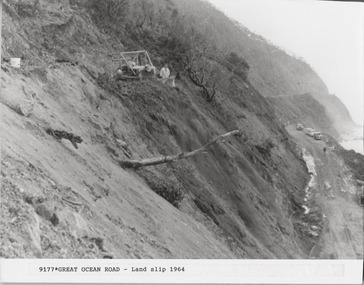 Lorne Historical Society
Photograph, Landslip Great Ocean Road 1964
Photograph 1964 showing bulldozers repairing cliff face after a landslip at Windy Point.Note 1950's cars. Note loose soil on cliff,g.o.r; landslip 1964; 1950's-cars; -
Glenelg Shire Council Cultural Collection
Photograph - Photograph - Cape Grant Quarry, n.d
Port of Portland Authority ArchivesBack: '(4)' - top right pencilport of portland archives, cape grant quarry -
Glenelg Shire Council Cultural Collection
Photograph - Photograph - Cape Grant Quarry, 03/02/1954
Port of Portland Authority ArchivesBack: Purple PHT stampport of portland archives, cape grant quarry -
Glenelg Shire Council Cultural Collection
Photograph - Photograph - Cape Grant Quarry, Portland, n.d
Port of Portland Authority Archivesport of portland archives, aerial photography, portland harbour, cape grant quarry -
Glenelg Shire Council Cultural Collection
Photograph - Photograph - Quarry, Cape Grant, n.d
Port of Portland Authority Archivesport of portland archives, cape grant quarry -
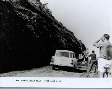 Lorne Historical Society
Photograph, Land Slip Great Ocean Road 1964
photography showing E.K. Holden vehicle registration HEZ 652, bulldozers and man holding stop sign at land slip on the Great Ocean Road 1962g.o.r; landslip-1964; ek- holden-vehicle -
Glenelg Shire Council Cultural Collection
Photograph - Photograph - Main Breakwater construction, Portland, Jul-54
Port of Portland Authority ArchivesBack: PHT Purple Stamp Print No. 4/39 Neg No. 260 Date Taken 14/7/54 Subject Main Breakwater from Battery Pointport of portland archives, harbour, portland, main breakwater, construction -
 Kiewa Valley Historical Society
Photographs x 2 1. Lake Guy & Bogong Village 2. Bulldozer moving rocks
1. In 1940 Field Headquarters for the Kiewa Scheme were established at Bogong with office, workshop facilities and accommodation for workmen, staff and some families constructed. (There had been a 'tent camp' on this site in 1939 but was destroyed by bushfires) Construction of accommodation continued until 1947. A total of 40 houses plus a hostel for single staff, post office, police station, medical centre and primary school all with water and sewerage and electricity supply. The staff hostel was known as Kiewa House and is now occupied by the Education Department. Lake Guy was named after Mr. L.T. Guy who was the Resident Engineer in charge of construction work and associated activities on the Kiewa area. He held this position from 1939 to November 1946 when he was transferred to Head Office. 2. Example of the type of heavy machinery used in clearing and building of Lake Guy, Bogong Village and Clover Dam 1. The Bogong Township was developed firstly as an accommodation centre (base camp) for construction workers employed under the Kiewa Hydroelectric Scheme. At the completion of the scheme, in the 1960's, the village was opened to public/tourism use. Strict environmental control has not allowed for any extensive redevelopment in tourist accommodation and basically restricted it to the accommodation initially built for the construction workers. Lake Guy is one of the many water storage reservoirs used to supply the power stations their main power to run the huge turbines generating the final product, electricity 2. Pictorial record of the types of machinery used in the development of Bogong Village and the Hydro-electricity scheme including the Clover Dam. Note the lack of safety equipment worn by construction workers of the period. 2 black and white photographs taken at Bogong 1. Lake Guy with Bogong Village in the background 2. Workman in bulldozer clearing rocks, possibly for construction at Bogong1. Handwritten in blue ink on back of photo 'Lake Guy showing Bogong Village' 2. No markingslake guy, bogong village, secv -
Glenelg Shire Council Cultural Collection
Photograph - Photograph - Cape Grant Quarry, 30/06/1955
Port of Portland Authority ArchivesBack: Purple PHT stampport of portland archives, cape grant quarry -
Glenelg Shire Council Cultural Collection
Photograph - Photograph - Cape Grant Quarry, n.d
Port of Portland Authority Archivesport of portland archives, cape grant quarry -
4th/19th Prince of Wales's Light Horse Regiment Unit History Room
Photo Album, AFV Recognition
Album containing photos of armoured vehicles: Centurions, Centurion/Chaffee suspension, Chaffees, Churchills, various, Comets, Cromwell, Covenanter Bridge Layer, Matilda Bulldozer & Flame thrower Magic Magnetic Photo Album, AR Clarke -
Glenelg Shire Council Cultural Collection
Photograph - Photograph - Cape Grant Quarry, 03/09/1954
Port of Portland Authority ArchivesBack: Purple PHT stampport of portland archives, cape grant quarry -
Glenelg Shire Council Cultural Collection
Photograph - Photograph - Portland Harbour Development, n.d
Port of Portland Authority Archivesport of portland archives -
Glenelg Shire Council Cultural Collection
Photograph - Photograph - Cape Grant Quarry, 30/06/1955
Port of Portland Authority ArchivesBack: Purple PHT stampport of portland archives, cape grant quarry -
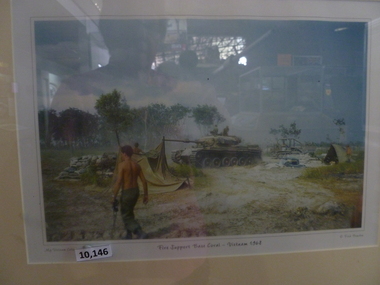 National Vietnam Veterans Museum (NVVM)
Print, Fire Support Base Coral - Vietnam 1968
Colour photo in brown, wooden frame 7 cream coloured matt board. Depicting a Centurion tank, bulldozer and 6 soldiers inside Fire Support Base Coral.My Vietnam collection. Fire Support Base Coral, Vietnam 1968 @ Fred Bowden.fire support base - coral -
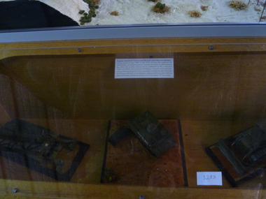 National Vietnam Veterans Museum (NVVM)
Model - Diorama
Consisting of three models modified for use in mine clearing. They are Patton M48 US tank; a M113 Armed personnel carrier (APC) named "Flint" and an armoured D8 bulldozer.HMAPC Flint & "Bukoo Boom Boom".mine clearing, m113, m48, diorama -
Glenelg Shire Council Cultural Collection
Photograph - Photograph - Cape Grant Quarry, n.d
Port of Portland Authority Archives -
Glenelg Shire Council Cultural Collection
Photograph - Photograph - Cape GRant Quarry, Portland, n.d
Port of Portland Authority Archivesport of portland archives, cape grant quarry, harbour development -
Glenelg Shire Council Cultural Collection
Photograph - Photograph - Cape Grant Quarry, n.d
Port of Portland Authority ArchivesBack: 'Harman excavator loading heavy rock at Cape Grant Quarry' - Green biro, bottom leftport of portland archives, cape grant quarry -
Glenelg Shire Council Cultural Collection
Photograph - Photograph - Main Breakwater construction, Portland, n.d
Port of Portland Authority Archivesport of portland archives, main breakwater, construction, portland, harbour, harbour development -
 Eltham District Historical Society Inc
Photograph, Looking east from the northern side of Lower Plenty Road (opposite Bannockburn Road) as it crosses the Watsonia Drain, Viewbank, c.1965, 1965c
Transmission power lines visible in distance behind the Lower Plenty Hotel (in centre upper) and parts of Heidelberg Golf Club. In the foreground a bulldozer can be seen commencing roadworks for the re-alignment of Lower Plenty Road for the new Lower Plenty Bridge crossing.Medium format 120 6x6 black and white negative film, 1 frameheidelberg golf club, lower plenty, lower plenty hotel, road construction, viewbank, watsonia drain -
Glenelg Shire Council Cultural Collection
Photograph - Photograph - Cape Grant Quarry, Jun-56
Port of Portland Authority ArchivesBack: 'June 1956 (2)' - pencilport of portland archives, cape grant quarry -
 National Vietnam Veterans Museum (NVVM)
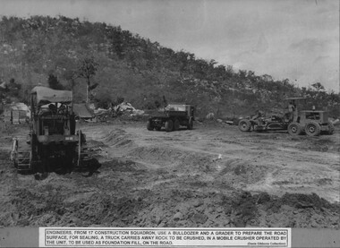
Photograph, Road Construction
A black and white photograph of Engineers from 17 Construction Squadron use a bulldozer and road grader to prepare the road surface for sealing. A truck carries away rock to be crushed, in a mobile crusher operated by the Unit, to be used for foundation fill, on the road.photograph, engineers, 17 const sqn, gibbons collection catalogue -
 National Vietnam Veterans Museum (NVVM)
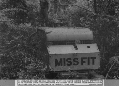
Photograph, Miss Fit
A black and white photograph of an armoured Engineer D8 bulldozer 'Miss Fit' involved in land and mine clearing operations up to the foothills of the Long Hai Mountains. The Engineer on the front of the D8 was directed. The driver, who could not see, because of the thicknss of the jungle.photograph, d8 bulldozer, long hai hills, engineers, gibbons collection catalogue -
 National Vietnam Veterans Museum (NVVM)
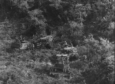
Photograph, Miss Fit
A black and white photograph of An armoured Engineer D8 bulldozer 'Miss Fit' involved in land and mine clearing operations up to the foothills of the Long Hai Mountains supported by Centurian Tanks and APCs out of Firebase Thrust (note there is no text at the bottom of the photograph)photograph, d8 bulldozer, centurion tank, armoured personnel carrier, long hai hills, firebase thrust, gibbons collection catalogue, d8 bulldozer, long hai mountains -
Glenelg Shire Council Cultural Collection
Photograph - Photograph - Cape Grant Quarry, n.d
Port of Portland Authority Archivesport of portland archives, cape grant quarry -
 Ballarat Tramway Museum
Photograph - Black & White Photograph/s - set of 12, 8/04/1973 12:00:00 AM
Yields information about the construction of the track and depot fan c 1972 and how the trams were positioned.Set of 12 Black and white photographs of the grading of the access track on 8/4/1973 between the level crossing and Wendouree Parade curve using Max McBain bulldozer and the follow up gravelling of the formation prior to track laying soon after. See May 1973 issue of Fares Please! for the date of the work.trams, tramways, access track, btps, construction -
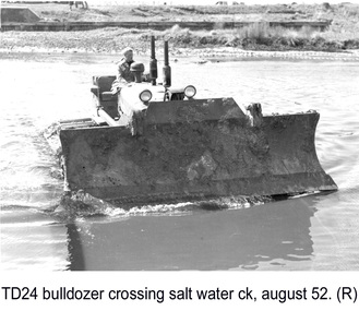 Glenelg Shire Council Cultural Collection
Photograph - Photograph - TD 24 Bulldozer crossing Salt Water Creek, 1962
Port of Portland Authority archivesFront: (no inscriptions) Back: P.H.T./ Print No. 15/2 Neg. No P18/ Date taken August 1962./ SUBJECT./ "TD 24" Bulldozer/ crossing Salt Water Creek (Ink stamp with blue pen and pencil additions, lower right) equ90 (pencil, center left) 15/2 (pen upper left)port of portland -
 Phillip Island and District Historical Society Inc.
Booklet, Cowes McRae Beach Estate, 1960s
This land was owned by the McRae family, whose wife was a Justice. Hence the street names of McRae and Justice. The weatherboard family home [ originally a guest house called Glen Isle] was at the end of the current Justice Road. The estate was created in the mid 1960s. The house was put on skids and dragged by two tractors and a bulldozer to 364 Church Street while the family home was built at 368 Church Street, Cowes.[ Source Sandra Rocotas, nee McCrae. Facebook Community Noticeboard 5/2/2023. Permission given to use information and photos ] Estate was sold by Rogan Real Estate.HistoricalColoured A4 brochure describing the McRae Beach Estate, including plan of streets and location on Island, photos and description of the Island. Sold by Rogan Real Estate.Cowes McRae Beach Estate - Right in the heart of things .Phillip Island - The Loveliest Isle on Earthhousing, justice family, mcrae family, glen isle guesthouse, cowes west, rogan real estate cowes phillip island