Showing 55 items matching "burnt bridge"
-
 Ringwood and District Historical Society
Research notes, John Rodaughan, Burnt Bridge Hotel - Newspaper clippings and handwritten notes including list of early owners. (Demolished 1964)
... Burnt Bridge Hotel - Newspaper clippings and handwritten notes including list of early owners. ...Newspaper clipping and collection of various sized handwritten notes on the history and a brief anecdote of Burnt Bridge Hotel including a list of the early owners of the hotel and a newspaper article on the closure of Burnt Bridge Store demolished in 1964....Early Burnt Bridge Hotel Owners; 1891-92 Thomas Willis; 1893-96 J.G. ...Ringwood and District Historical Society 125A Warrandyte Road Ringwood North melbourne Early Burnt Bridge Hotel Owners; 1891-92 Thomas Willis; 1893-96 J.G. ...Newspaper clipping and collection of various sized handwritten notes on the history and a brief anecdote of Burnt Bridge Hotel including a list of the early owners of the hotel and a newspaper article on the closure of Burnt Bridge Store demolished in 1964.Early Burnt Bridge Hotel Owners; 1891-92 Thomas Willis; 1893-96 J.G. Jones; 1897-00 Sammuel ?; 1901 Mary Hampton; 1902-05 ? Smith; 1906-07 Miss Clarke; 1908-09 Hacke ?; 1910-12 Frank J Hack; 1913 Frank Johnson; 1914 Sidney R Ritchie; 1915 Mrs S Rowlands; 1916 Mrs M Pearson -
Ringwood and District Historical Society
Letter, Personal correspondence - 1985 - including reference to purchase of Burnt Bridge Store by parents of Clarice de Pelsenaire in 1923 and brief history and death of Ringwood East resident, Arthur Meyland (1911-1985)
... Personal correspondence - 1985 - including reference to purchase of Burnt Bridge Store by parents of Clarice de Pelsenaire in 1923 and brief history and death of Ringwood East resident, Arthur Meyland (1911-1985)....Incomplete letter from Clarice dePelsenaide, whose parents purchased the Burnt Bridge Store from Mr Williams. Her husband Arthur was the first pupil enrolled at the Ringwood East Primary School....2 pages hand written letter about early East Ringwood and Burnt Bridge Store. +Additional Keywords: dePelsenaide, Clarice...Incomplete letter from Clarice dePelsenaide, whose parents purchased the Burnt Bridge Store from Mr Williams. Her husband Arthur was the first pupil enrolled at the Ringwood East Primary School. 2 pages hand written letter about early East Ringwood and Burnt Bridge Store. ...Incomplete letter from Clarice dePelsenaide, whose parents purchased the Burnt Bridge Store from Mr Williams. Her husband Arthur was the first pupil enrolled at the Ringwood East Primary School.2 pages hand written letter about early East Ringwood and Burnt Bridge Store. +Additional Keywords: dePelsenaide, Clarice -
Ringwood and District Historical Society
Envelope, Packet: History of Nelson Hill (Burnt Bridge) Post Office, Ringwood
... Packet: History of Nelson Hill (Burnt Bridge) Post Office, Ringwood...History of Nelson Hill (Burnt Bridge) Post Office...Ringwood and District Historical Society 125A Warrandyte Road Ringwood North melbourne History of Nelson Hill (Burnt Bridge) Post Office Packet: History of Nelson Hill (Burnt Bridge) Post Office, Ringwood Envelope ...History of Nelson Hill (Burnt Bridge) Post Office -
 Ringwood and District Historical Society
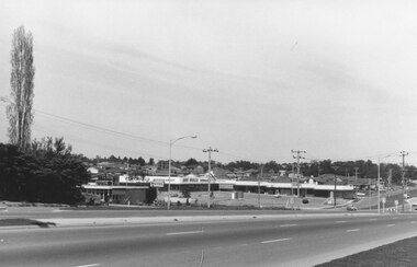
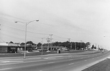
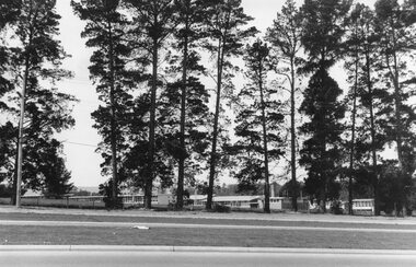
Photograph, Maroondah Highway East, Ringwood- 1969. Burnt Bridge Shopping Centre, cnr Maroondah Hwy and Beaufort Road
... Maroondah Highway East, Ringwood- 1969. Burnt Bridge Shopping Centre, cnr Maroondah Hwy and Beaufort Road....Written on back of photograph: "Site of Burnt Bridge Hotel - (later a store). Nov 1969."...Ringwood and District Historical Society 125A Warrandyte Road Ringwood North melbourne Written on back of photograph: "Site of Burnt Bridge Hotel - (later a store). Nov 1969." ...Black and white photographWritten on back of photograph: "Site of Burnt Bridge Hotel - (later a store). Nov 1969." -
 Ringwood and District Historical Society
Photograph-B&W, Joan Walker, East Ringwood 2000-Burnt Bridge Shopping Centre, Maroondah Highway, 2000
... East Ringwood 2000-Burnt Bridge Shopping Centre, Maroondah Highway...East Ringwood 2000-Burnt Bridge Shopping Centre, Maroondah Highway- B&W Photo from Album 6501...Ringwood and District Historical Society 125A Warrandyte Road Ringwood North melbourne East Ringwood 2000-Burnt Bridge Shopping Centre, Maroondah Highway- B&W Photo from Album 6501 East Ringwood 2000-Burnt Bridge Shopping Centre, Maroondah Highway Photograph-B&W Joan Walker ...East Ringwood 2000-Burnt Bridge Shopping Centre, Maroondah Highway- B&W Photo from Album 6501 -
 Ringwood and District Historical Society
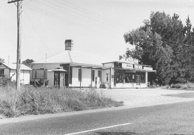
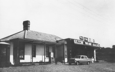
Photograph, Burnt Bridge Store, Feb 1960 (2 views)
... Burnt Bridge Store, Feb 1960 (2 views)...On another copy: "Old Burnt Bridge Hotel (Sam Cutts)"...On another copy: "Old Burnt Bridge Hotel (Sam Cutts)" Burnt Bridge Store, Feb 1960 (2 views) Photograph ...Written on back of one photograph, "Burnt Bridge Store. Demolished 1969. New World super market and shops built on or about site. Feb. 1960". On another copy "Ex BB Hotel, Demolished 3-4.69". On another copy: "Old Burnt Bridge Hotel (Sam Cutts)" -
 Ringwood and District Historical Society
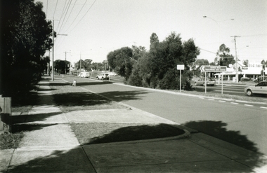
Photograph, Joan Walker, East Ringwood 2000 - Burnt Bridge taken from Maroondah Highway just near Kalinda Road, 2000
... East Ringwood 2000 - Burnt Bridge taken from Maroondah Highway just near Kalinda Road...East Ringwood 2000 - Burnt Bridge Shopping Centre taken from Maroondah Highway just near Kalinda Road - B&W Photo from Album 6501...Ringwood and District Historical Society 125A Warrandyte Road Ringwood North melbourne East Ringwood 2000 - Burnt Bridge Shopping Centre taken from Maroondah Highway just near Kalinda Road - B&W Photo from Album 6501 East Ringwood 2000 - Burnt Bridge taken from Maroondah Highway just near Kalinda Road Photograph Joan Walker ...East Ringwood 2000 - Burnt Bridge Shopping Centre taken from Maroondah Highway just near Kalinda Road - B&W Photo from Album 6501 -
Ringwood and District Historical Society
Notes for book, Rogaughan, John, Material for History of Kilsyth, Croydon, Burnt Bridge and Ringwood (book never completed). By John Rogaughan (undated), not known
... Material for History of Kilsyth, Croydon, Burnt Bridge and Ringwood (book never completed). ...Collected for a history book of Kilsyth, Croydon, Burnt Bridge and Ringwood but never completed....+Additional Keywords: Rogaughan, John Material for History of Kilsyth, Croydon, Burnt Bridge and Ringwood (book never completed). ...Collected for a history book of Kilsyth, Croydon, Burnt Bridge and Ringwood but never completed.27 pages of notes intended for a local history book typed with some connections. +Additional Keywords: Rogaughan, John -
 Buninyong & District Historical Society
Photograph - Historical Excursion, Nov 1997, Williamson's Creek Historical Excursion 1997
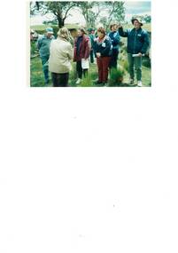
... ...Burnt Bridge...Burnt Bridge, Williamson's Creek was an early crossing point for travellers between Geelong and Buninyong in the 19 century and continued to be a significant area when farming developed in the district. ...Members of Buninyong and District Historical on an excursion to a property near Burnt Bridge, Williamson's Creek Nov 1997...This photograph is a record of Buninyong and District Historical Society's ongoing activities in areas of local significance Buninyong and District Historical Society Burnt Bridge Williamson's Creek Williamson's Creek, Historical Excursion Nov 1997 Members of Buninyong and District Historical on an excursion to a property near Burnt Bridge, Williamson's Creek Nov 1997 Williamson's Creek Historical Excursion 1997 Photograph Historical Excursion, Nov 1997 ...Burnt Bridge, Williamson's Creek was an early crossing point for travellers between Geelong and Buninyong in the 19 century and continued to be a significant area when farming developed in the district. This photograph is part of the ongoing collection of the Buninyong and District Historical Society to record the society's activities.This photograph is a record of Buninyong and District Historical Society's ongoing activities in areas of local significance Members of Buninyong and District Historical on an excursion to a property near Burnt Bridge, Williamson's Creek Nov 1997Williamson's Creek, Historical Excursion Nov 1997buninyong and district historical society, burnt bridge, williamson's creek -
 Ringwood and District Historical Society
Photograph, Burnt Bridge Store (undated but post 1962)
... Burnt Bridge Store (undated but post 1962)...Written below photograph, "Burnt Bridge Store". No date, but car has been identified by Peter Fry as an EJ Holden, which was produced by General Motors-Holden's in Australia from 1962 to 1963....[Introduced in July 1962, So this photo is sometime after 1962 Burnt Bridge Store (undated but post 1962) Photograph Photograph ...Written below photograph, "Burnt Bridge Store". No date, but car has been identified by Peter Fry as an EJ Holden, which was produced by General Motors-Holden's in Australia from 1962 to 1963.[Introduced in July 1962, So this photo is sometime after 1962 -
Ringwood and District Historical Society
Envelope, Packet: Ringwood Area Hotels - Coach and Horses, Empress India, Burnt Bridge. Also Antimony Mine Hotel Proclaimed 1878
... Packet: Ringwood Area Hotels - Coach and Horses, Empress India, Burnt Bridge. Also Antimony Mine Hotel Proclaimed 1878...Hotels list; Coach and Horses Hotel; Club Hotel Sept-1887 Wiggin sold to Lindsey; Empress India Hotel; Antimony Mine Hotel, East Ringwood, Cnr Main & Pratt St proclaimed 21-Jan-1878 owing to increase in mining population, 4 licences in locality; Burnt Bridge Hotel; "Duke of York"...Ringwood and District Historical Society 125A Warrandyte Road Ringwood North melbourne Hotels list; Coach and Horses Hotel; Club Hotel Sept-1887 Wiggin sold to Lindsey; Empress India Hotel; Antimony Mine Hotel, East Ringwood, Cnr Main & Pratt St proclaimed 21-Jan-1878 owing to increase in mining population, 4 licences in locality; Burnt Bridge Hotel; "Duke of York" Packet: Ringwood Area Hotels - Coach and Horses, Empress India, Burnt Bridge. ...Hotels list; Coach and Horses Hotel; Club Hotel Sept-1887 Wiggin sold to Lindsey; Empress India Hotel; Antimony Mine Hotel, East Ringwood, Cnr Main & Pratt St proclaimed 21-Jan-1878 owing to increase in mining population, 4 licences in locality; Burnt Bridge Hotel; "Duke of York" -
 Ringwood and District Historical Society
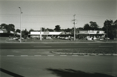
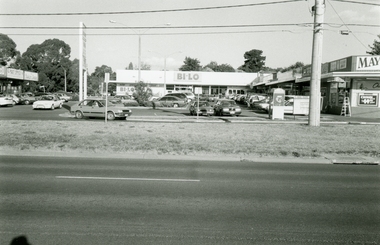
Photographs, Burnt Bridge Shopping Centre, East Ringwood in 1999
... Burnt Bridge Shopping Centre, East Ringwood in 1999...Ringwood and District Historical Society 125A Warrandyte Road Ringwood North melbourne Burnt Bridge Shopping Centre, East Ringwood in 1999 Photographs ... -
 Ringwood and District Historical Society
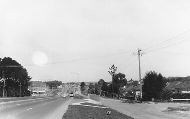
Photograph, Maroondah Highway East, Ringwood- 1969. Looking west towards Ringwood past Burnt Bridge shopping centre
... Looking west towards Ringwood past Burnt Bridge shopping centre....Looking west towards Ringwood past Burnt Bridge shopping centre. Photograph ...Black and white photograph -
 Ringwood and District Historical Society
Photograph, Maroondah Highway East, Ringwood- 1969. Looking west towards Ringwood from Burnt Bridge area
... Looking west towards Ringwood from Burnt Bridge area....Looking west towards Ringwood from Burnt Bridge area. Photograph ...Black and white photograph -
 Ringwood and District Historical Society
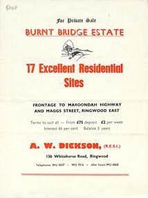
Flyer, Land Sale Brochure, Burnt Bridge Estate, Ringwood East/Croydon, Vic. - circa 1959
... Land Sale Brochure, Burnt Bridge Estate, Ringwood East/Croydon, Vic. - circa 1959...Bi-folded single sheet with black and red print both sides including subdivision features and local facilities Land Sale Brochure, Burnt Bridge Estate, Ringwood East/Croydon, Vic. - circa 1959 Flyer ...Bi-folded single sheet with black and red print both sides including subdivision features and local facilitiesSubdivision layout includes Marcus Road, Maggs Street and Maroondah Highway Croydon/Ringwood East. (Agent) A.W. Dickson, 136 Whitehorse Road, Ringwood, Telephones WU 6007, WU 7016, after hours WU 6868. -
 Buninyong & District Historical Society
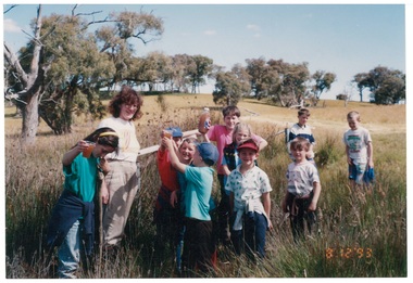
Photograph - Colour photograph of Clarendon State School excursion to Williamson's Creek 1993, Clarendon State School excursion to Williamson's Creek 1993
... ...Burnt Bridge...Colour photo, Clarendon State School excursion to Mineral Springs, Burnt Bridge, Williamson's Creek 1993, last excursion before school closed, led by Ann Beggs Sunter...Buninyong & District Historical Society Old Court House, Buninyong Town Hall 313 Learmonth Street Buninyong goldfields Clarendon School excursion mineral springs Burnt Bridge Williamson's Creek Colour photo, Clarendon State School excursion to Mineral Springs, Burnt Bridge, Williamson's Creek 1993, last excursion before school closed, led by Ann Beggs Sunter Clarendon State School excursion to Williamson's Creek 1993 Photograph Colour photograph of Clarendon State School excursion to Williamson's Creek 1993 ...Colour photo, Clarendon State School excursion to Mineral Springs, Burnt Bridge, Williamson's Creek 1993, last excursion before school closed, led by Ann Beggs Sunterclarendon school, excursion, mineral springs, burnt bridge, williamson's creek -
Ringwood and District Historical Society
Document, Burnt Bridge:some details - 1843 to 1971
... Single page of typed notes on the history of Burnt Bridge from 1843 to 1971...Ringwood and District Historical Society 125A Warrandyte Road Ringwood North melbourne Single page of typed notes on the history of Burnt Bridge from 1843 to 1971 Burnt Bridge:some details - 1843 to 1971 Document ...Single page of typed notes on the history of Burnt Bridge from 1843 to 1971 -
 Ringwood and District Historical Society
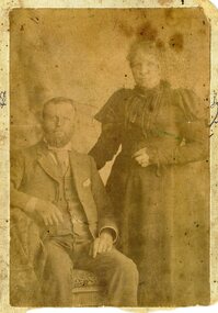
Photograph, Samuel & Elizabeth Cutts- year and place unknown
... "Written on back of photograph" Samuel & Elizabeth Cutts Additional Note - Samual Cutts was the owner of Burnt Bridge Hotel....Ringwood and District Historical Society 125A Warrandyte Road Ringwood North melbourne "Written on back of photograph" Samuel & Elizabeth Cutts Additional Note - Samual Cutts was the owner of Burnt Bridge Hotel. Sepia photograph Samuel & Elizabeth Cutts- year and place unknown Photograph ...Sepia photograph"Written on back of photograph" Samuel & Elizabeth Cutts Additional Note - Samual Cutts was the owner of Burnt Bridge Hotel. -
 Lakes Entrance Historical Society
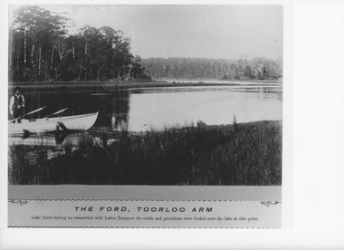
Photograph - The Ford Toorloo Arm Lake Tyers Victoria, Caire, Nicholas John, 1905c
... Black and white photograph of the ford across Lake Tyers from Toorloo Arm in the vicinity of Burnt Bridge to the wooded point. Lake Tyers Victoria...Waterways Topography The Ford Toorloo Arm Black and white photograph of the ford across Lake Tyers from Toorloo Arm in the vicinity of Burnt Bridge to the wooded point. Lake Tyers Victoria Photograph The Ford Toorloo Arm Lake Tyers Victoria Caire, Nicholas John ...The Ford, Toorloo Arm, Lake Tyers having no connection with Lakes Entrance, the cattle and provisions were forded over the lake at this point.Black and white photograph of the ford across Lake Tyers from Toorloo Arm in the vicinity of Burnt Bridge to the wooded point. Lake Tyers VictoriaThe Ford Toorloo Armwaterways, topography -
 Lakes Entrance Historical Society
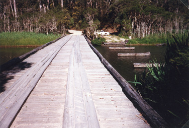
Photograph - Bridges, Fish Marie, 1965
... Black and white photograph showing the old Burnt Bridge over Toorloo Arm before being closed to vehicular traffic, near Lakes Entrance, Victoria,...Lakes Entrance Historical Society 4 Marine Parade Lakes Entrance gippsland Also scanned photograph of a vehicle crossing the original bridge Bridges Waterways Black and white photograph showing the old Burnt Bridge over Toorloo Arm before being closed to vehicular traffic, near Lakes Entrance, Victoria, Photograph Bridges Fish Marie ...Also scanned photograph of a vehicle crossing the original bridgeBlack and white photograph showing the old Burnt Bridge over Toorloo Arm before being closed to vehicular traffic, near Lakes Entrance, Victoria,bridges, waterways -
 Lakes Entrance Historical Society
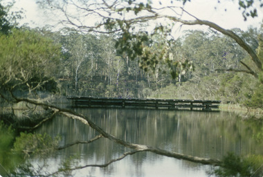
Photograph - Bridges, 1998
... Colour photograph of the crossing at Toorloo Arm on the previous main road from Lakes Entrance to Nowa Nowa known as Burnt Bridge. Lakes Entrance Victoria...Lakes Entrance Historical Society 4 Marine Parade Lakes Entrance gippsland Also photograph of bridge from different angle Bridges Waterways Vegetation Colour photograph of the crossing at Toorloo Arm on the previous main road from Lakes Entrance to Nowa Nowa known as Burnt Bridge. Lakes Entrance Victoria Photograph Bridges ...Also photograph of bridge from different angleColour photograph of the crossing at Toorloo Arm on the previous main road from Lakes Entrance to Nowa Nowa known as Burnt Bridge. Lakes Entrance Victoriabridges, waterways, vegetation -
 Ringwood and District Historical Society
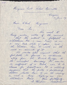
Letter - clipping, Letter to Town Clerk Ringwood 1939 from Ringwood East Primary re Footpath culvert
... Also requesting that the footpatch be formed or continued along from the Burnt Bridge to the municipal boundary....Also requesting that the footpatch be formed or continued along from the Burnt Bridge to the municipal boundary. Letter to Town Clerk Ringwood 1939 from Ringwood East Primary re Footpath culvert Letter clipping ...A letter dated 30 June 1939 to the Town Clerk Ringwood from E Thompson Ringwood East School Committee advising the Council that the culvert on footpath in Whitehorse Road is in a very bad state of repair. Also requesting that the footpatch be formed or continued along from the Burnt Bridge to the municipal boundary. -
Ringwood and District Historical Society
Document, Early Historical Background of the Area Adjancent to Marrondah High School (1855 - 1974), by Eva Buchanan (Handwritten Photocopy Plus Transcription, undated)
... Includes references to Nelson's Hill, Burnt Bridge, Cutts Avenue naming, Samuel Cutts, W. ...Includes references to Nelson's Hill, Burnt Bridge, Cutts Avenue naming, Samuel Cutts, W. ...6 page photocopy of handwritten History of the Area adjacent to Marrondah High School, by Eva Buchanan. Also a Word Trasncription of same. Date unknown. Includes references to Nelson's Hill, Burnt Bridge, Cutts Avenue naming, Samuel Cutts, W. S. (Billy) WIlliams, de Pelsenaire family, Cheevers family, Brentnall Road naming, Muldowney Family, Alfred Brentnall, Ainslee Park. -
 Ringwood and District Historical Society
Photograph, Croydon West High School off Cutts Avenue and Maroondah Hwy, Ringwood - November, 1969
... It was later sub-divided and the two streets named Wilhelmina and Juliana Courts, in honor of Wilhelmina, Queen of the Netherlands, and her daughter, Juliana, later succeeding her as Queen. The Burnt Bridge Shopping Centre can be seen in the far west on one of the images. ...It was later sub-divided and the two streets named Wilhelmina and Juliana Courts, in honor of Wilhelmina, Queen of the Netherlands, and her daughter, Juliana, later succeeding her as Queen. The Burnt Bridge Shopping Centre can be seen in the far west on one of the images. ...Written on backing sheet, "West Croydon School (In Ringwood municipality)". November 1969. The area behind the pine trees was used as a training ground by the Wilhelmina Soccer Club, later called Ringwood City SC and Ringwood FC. It was later sub-divided and the two streets named Wilhelmina and Juliana Courts, in honor of Wilhelmina, Queen of the Netherlands, and her daughter, Juliana, later succeeding her as Queen. The Burnt Bridge Shopping Centre can be seen in the far west on one of the images. -
 Ringwood and District Historical Society
Work on paper - Pencil sketch, Artist unknown, initials D.M, Sketch of pottery kilns at East Ringwood, corner of Velma Grove and Mount Dandenong Road (Oxford Road). Kilns shut down in 1926, c.1926
... Judging by the handwriting, the artist and author appears to be John Rodaughan, East Ringwood historian, whose other works include history on Burnt Bridge Hotel and other parts of East Ringwood. ...Judging by the handwriting, the artist and author appears to be John Rodaughan, East Ringwood historian, whose other works include history on Burnt Bridge Hotel and other parts of East Ringwood. ...Sketch of the four pottery kilns at East Ringwood, corner of Velma Grove and Mount Dandenong Road (Oxford Road). The kilns shut down in 1926. Judging by the handwriting, the artist and author appears to be John Rodaughan, East Ringwood historian, whose other works include history on Burnt Bridge Hotel and other parts of East Ringwood. The back of the sketch includes a rough hand-drawn map, that appears to be of the insulator works area, between Mt Dandenong Road and Evon Avenue. The timeline includes generic milestones in blue ink and those associated with Ringwood in red writing.Kilns; D.M. -
 Halls Gap & Grampians Historical Society
Photograph - B/W, C 1880
... Balmain purchased the vacant school cottage at Burnt Bridge and moved it to 'Bellfield' Over the next six years the house was enlarged to accommodate their growing family but sold in 1902 following the death of Amy Balmain....Balmain purchased the vacant school cottage at Burnt Bridge and moved it to 'Bellfield' Over the next six years the house was enlarged to accommodate their growing family but sold in 1902 following the death of Amy Balmain. ...1880-1902 Land owned by Robert and Sarah Graham who owned a large portion of land best described as Upper Fyans Valley. At some time after 1880, they sold a parcel of the land under Sundial Peak to David Austin who built a slab hut. C1896, The land was sold to James and Amy Balmain which they named 'Bellfield' Amy was a daughter of John D/Alton who built the Stawell Water Supply System. Balmain purchased the vacant school cottage at Burnt Bridge and moved it to 'Bellfield' Over the next six years the house was enlarged to accommodate their growing family but sold in 1902 following the death of Amy Balmain.House with addition People leaving house by horse and carriage, people standing in groundsState Library Victoria, Rose's Australasian Views Victorian Series photographed and published by George Rose 123 Chapel St., Windsor, Victoriabuildings, houses, bellfield -
 Ringwood and District Historical Society
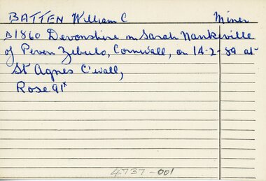
Document - Index Cards, Ringwood - Incomplete set of 17 Index Cards with names of local residents from B to J
... . - Grazier Howship, Charles Burton - Mount cutter (pictures) Howship, Charles Lawrence - Picture framer Jones, George J - Burnt Bridge Hotel Keeper.... - Grazier Howship, Charles Burton - Mount cutter (pictures) Howship, Charles Lawrence - Picture framer Jones, George J - Burnt Bridge Hotel Keeper Ringwood - Incomplete set of 17 Index Cards with names of local residents from B to J Document Index Cards ...The index cards have very brief details of each personIncomplete set of 17 small Index Cards with names of local residents from B to J, biographical information, children, residences etc. Undated, and writer unknown. Names are: Batten, William C. - Miner; Brakewell, John - Labourer Cox, Joseph - Miner Curran, John - Storekeeper Cutts, Samuel - Publican Cutts, James Bennitt - Labourer Ditchburn, William - Brickmaker Drury, John R. - Miner Dynes,Joseph - Miner Eyre,Francis - Brickmaker Hill, David Gilchrist - Labourer Hill, John - Brickmaker Hill, Will Henry - Florist Hill, Ninian C. - Grazier Howship, Charles Burton - Mount cutter (pictures) Howship, Charles Lawrence - Picture framer Jones, George J - Burnt Bridge Hotel Keeper -
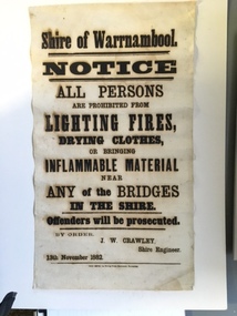 Warrnambool and District Historical Society Inc.
Document, Shire of Warrnambool Fire - Washing-Bridge 1882, 1882
... But the reality of bridges providing shelter and warmth in the colder months and the ensuring fires and burnt bridges has more than likely precipitated this notice. ...But the reality of bridges providing shelter and warmth in the colder months and the ensuring fires and burnt bridges has more than likely precipitated this notice. ...This notice relates to the prohibition of lighting fires,drying clothes or bringing inflamable material near any of the bridges in the shire. Offenders will be prosecuted. With a date of 1882 and the fact that bridges were mostly made of wood, it would have been of concern that the destruction of bridges was not only of great inconvenience but also of considerable expense. But the reality of bridges providing shelter and warmth in the colder months and the ensuring fires and burnt bridges has more than likely precipitated this notice. J W Crawley was shire engineer from 1876 until 1895 and for 10 of those years he trained his son J W Crawley who succeeded his father and served in the position for 40 years.He in turn was succeeded by his son Rolf Crawley in 1935. In 1963 the bridge over the Hopkins Falls at Wangoom was named the Crawley bridge in honour of service to the Shire of Warrnambool by members of the Crawley family. The Shire of Warrnambool was proclaimed in 1863 and covered an area of over 600 square miles. Much of it was incorporated into the Moyne Shire in the 1990's with some being included into the boundaries of City of Warrnambool. This banner is an interesting piece of history. It shows the issues confronting early settlers such as shelter and the chores of daily life but also the importance placed on infrastructure which was slowly taking place around the district. It was in the era of drainage and roadworks and hence bridges were an important part of that infrastructure. The name J W Crawley is one of importance in the Warrnambool district for his service over many years. Rectangular piece of cloth printed in black ink. The back is plain.Shire of Warrnambool By order of J W Crawley Shire Engineer, 13th November 1882. Thos Smith gas Printing Works Koroit Street Warrnambool.warrnambool, shire of warrnambool, bridges of warrnambool shire, j w crawley, warrnambool shire engineer, crawleys of warrnambool -
Ringwood and District Historical Society
Document, Property Research Notes - The History of 18 Vista Avenue, Ringwood East, Victoria
... Presumably the demolition contractor had already been paid to demolish, remove and dump the building rubble by the developer of the Burnt Bridge shopping centre and now was able to on-sell the bricks without the cost of disposal. ...Presumably the demolition contractor had already been paid to demolish, remove and dump the building rubble by the developer of the Burnt Bridge shopping centre and now was able to on-sell the bricks without the cost of disposal. ...Single A4 page summary of the house and land prepared for real estate purposes by un-named author, undated, circa 1990s.The History Of 18 Vista Avenue, Ringwood East The Land The current block located at 18 Vista Avenue was originally part of an 80 acre block granted to R Blood on 12 March 1872. A Wallace Bruce subsequently sold off a portion of this land and on it the Davies family erected the house "Reaghill" shortly after 1909. A 35 acre parcel of this original block was subdivided into 22 lots in June 1955. The subdivision consisted of 15 lots from 1½ and 2½ acres and seven smaller blocks of about ½ acre fronting Bedford Road. The 18 Vista Avenue block, then just over 2 acres was purchased by Mr Campbell Boyd, a local pharmacist, in 1956. The purchase price was £1000. Mr Boyd became sick not long after acquiring the land and offered the property, then a bush block, to Dr Arthur G Stephens. Dr Stephens purchased the block for £2,500 in 1959. The block was not immediately built on. Dr and Mrs Stephens said they were not able to afford a new building on the Vista Avenue block at the time, so relocated their house from 302 Maroondah Highway, near the current site of the Maroondah City Council, to the current location on the block. The garden design was created by Gloria Parker from Park Orchards and included a variety of roses and unusual species of plants. The House The house which was built in 1959, was successfully moved in two pieces in 1972, from Maroondah Highway, under the railway crossing at Ringwood East and up Scenic Avenue. The route through the railway crossing on Dublin Road required the removal of the top four feet of roof from the building so it would fit under the overhead wires. The building was cut along the entrance hall and when put together the join was barely perceptible. The saw cuts on each side of the house when rejoined, were said to have matched exactly. There were originally two brick fireplaces in the house, one in the lounge (an Adams design) and the second in the library. The library fireplace was not reconstructed after the house was relocated. The bricks and bluestone slabs, which form a substantial part of the structure of the formal garden around the house, were salvaged from the demolition of the Burnt Bridge Hotel. Dr Stephens bought 32 truckloads of uncleaned bricks from the demolition contractor for $1 per load. Presumably the demolition contractor had already been paid to demolish, remove and dump the building rubble by the developer of the Burnt Bridge shopping centre and now was able to on-sell the bricks without the cost of disposal. These bricks make up the first three feet of the brick wall which encompasses the secret garden. This wall originally marked the start of a terraced area which extended back to the Vista Avenue road frontage. The large bluestone slabs making up most of the steps in the garden were the door steps on the old hotel and the large square roughmade bricks were originally the foundation stones for the stumps of the Burnt Bridge building. The terraced area and land to the south of the tennis court (the current 16A to 16E Vista Avenue) was sold off to Bovis Homes after the nine year covenant expried on the land. -
Ringwood and District Historical Society
Scrap Book, Scrap book of Mr. J.K. Turnbull, Ringwood's first Station Master, containing correspondence, newspaper clippings, obituaries and personal memorabilia c.1890-1913, c. 1890 - 1913
... .; Note: Cutts, Elizabeth - owned the hotel at Burnt Bridge; Mr McCaskill was mayor and first President of the Historical Society; Carter, Alan - was father of Richard Carter. ....; Note: Cutts, Elizabeth - owned the hotel at Burnt Bridge; Mr McCaskill was mayor and first President of the Historical Society; Carter, Alan - was father of Richard Carter. ...Mr J.K. Turnbulls own scrap book lent by his son to Mr McCaskill. Alan Carter got it from Mr McCaskill to return but the son died and Alan Carter gave it to the Historical Society. Mr Turnbull was Ringwood's first Station Master and a well liked person in the community.Mr J.K. Turnbulls own scrap book. Large blue cardboard covers with black and red embossing and 'Scraps' on front. Blue cloth spine. No pages held by spine - five with cuttings from papers pasted on to them; three handwritten letters; several single cuttings.; 1. Five pages of newspaper cuttings pasted to page.; 2. Post Office Telegraphs 14-Jan-1891; 3. Small ad. - Frank Lowe - is running a waggonette to meet every train - stables - 'Coach and Horses Hotel' 12-Jan-1913; 4. Mr Turnbull at Healesville; a favourite Returns; two cuttings with same story.; 5. Photocopy of the 'Programme of Dances for the Opening of the Ringwood Goods Shed' Monday 28 December 1887.; 6. Handwritten in pencil - New Goods Shed 28/11/1887. Opening ceremony 2-Dec-1887 - not very legible - 4 pages (15 x 10cm); 7. Two letters to Mr Turnbull from John Ross - 17-Jan-1891; 8. Letter from Samuel and Elizabeth Cutts and family to Mr Turnbull.; Note: Cutts, Elizabeth - owned the hotel at Burnt Bridge; Mr McCaskill was mayor and first President of the Historical Society; Carter, Alan - was father of Richard Carter. +Additional Keywords: Turnbull, J.K. / McCaskill, Mr / Carter, Alan / Lowe, Frank / Ross, John / Cutts, Samuel / Cutts, Elizabeth'Scraps'