Showing 12928 items matching "buying or selling house or land"
-
 Orbost & District Historical Society
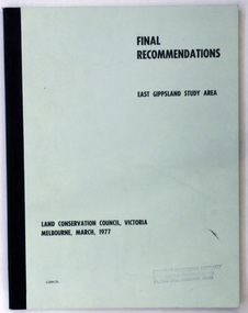
document, FINAL RECOMMENDATIONS E. GIPPSLAND STUDY AREA - LAND CONSERVATION COUNCIL, VICTORIA March 1977, March 1977
... GIPPSLAND STUDY AREA - LAND CONSERVATION COUNCIL, VICTORIA March 1977...land-conservation-East-Gippsland...Established in 1971, the Land Conservation Council operated under the Land Conservation Council Act 1970. ...A document of 75 pp with a pale green cover and black print, titled Final Recommendations East Gippsland Study area. Land Conservation Council, Melbourne, March, 1977....Land Conservation Council...Orbost & District Historical Society Ruskin Street Orbost gippsland Established in 1971, the Land Conservation Council operated under the Land Conservation Council Act 1970. ...Established in 1971, the Land Conservation Council operated under the Land Conservation Council Act 1970. In July 1997, the Environment Conservation Council Act 1997 came into operation. This Act revoked the Land Conservation Council Act 1970 and abolished the Land Conservation Council. An Environment Conservation Council was established in its place. (ref. TROVE) This document is a useful reference tool.A document of 75 pp with a pale green cover and black print, titled Final Recommendations East Gippsland Study area. Land Conservation Council, Melbourne, March, 1977.land-conservation-east-gippsland -
 Whitehorse Historical Society Inc.
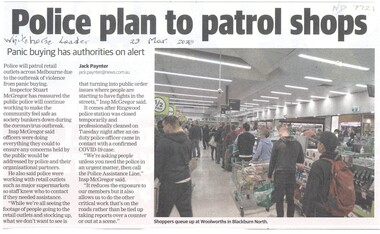
Article, Panic Buying
... Panic Buying...Police will patrol retail outlets across Melbourne due to the outbreak of violence from panic buying caused by coronavirus covid-19....Panic Buying Article Article ...Police will patrol retail outlets across Melbourne due to the outbreak of violence from panic buying caused by coronavirus covid-19.Police will patrol retail outlets across Melbourne due to the outbreak of violence from panic buying caused by coronavirus covid-19.Police will patrol retail outlets across Melbourne due to the outbreak of violence from panic buying caused by coronavirus covid-19.city of whitehorse, police, shopping centres -
 Ringwood and District Historical Society
Land Sale Documents, Board of Land and Works, Documents pertaining to application for a land grant around Ringwood Lake in 1874, 30-May-1870 and 25-Mar-1874
... Land Sale Documents...Documents pertaining to application for a land grant around Ringwood Lake in 1874....This concerns the application and granting of land to Anthony Ford around the Ringwood lake area in 1874. ...Documents pertaining to application for a land grant around Ringwood Lake in 1874. Copied documents, cream paper. 8pp. ...Board of Land and Works...+Additional Keywords: Ford, Anthony / Kennedy, James Documents pertaining to application for a land grant around Ringwood Lake in 1874. Land Sale Documents Board of Land and Works ...This concerns the application and granting of land to Anthony Ford around the Ringwood lake area in 1874. Includes details of improvements made to the area, including a dwelling. The land is described as being very poor and not worth the labour of cultivation. 8pp.Documents pertaining to application for a land grant around Ringwood Lake in 1874. Copied documents, cream paper. 8pp. +Additional Keywords: Ford, Anthony / Kennedy, James -
 Whitehorse Historical Society Inc.
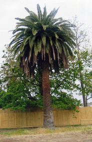
Photograph, Palm tree on original Schwerkolt Land, 1/10/2007 12:00:00 AM
... Palm tree on original Schwerkolt Land...Coloured photo taken in October 2007 of the palm tree planted by August Schwerkolt on land now owned by Council....Orchard Land of Complex...Whitehorse Historical Society Inc. 2-10 Deep Creek Road Mitcham melbourne schwerkolt palm trees Coloured photo taken in October 2007 of the palm tree planted by August Schwerkolt on land now owned by Council. Palm tree on original Schwerkolt Land Photograph Photograph ...Coloured photo taken in October 2007 of the palm tree planted by August Schwerkolt on land now owned by Council.schwerkolt, palm trees -
University of Melbourne, Burnley Campus Archives
Journal - Journal Extract, Melbourne School of Land and Environment, Land & Environment, Summer 2013
... Land & Environment...Article in Land & Environment Summer 2013 p 13. "Burnley Gardens 150th."...Melbourne School of Land and Environment...Land & Environment Journal Journal Extract Melbourne School of Land and Environment ...150th celebrations, burnley gardens -
Lakes Entrance Historical Society
Book, Land Conservation Council Victoria, The Gippsland Lakes Land Use Strategy Plan 1978, 1985
... The Gippsland Lakes Land Use Strategy Plan 1978...A review of public land use in the East Gippsland area, including natural resources, flora and fauna, recreation. ...Land Conservation Council Victoria...The Gippsland Lakes Land Use Strategy Plan 1978 Book Land Conservation Council Victoria ...A review of public land use in the East Gippsland area, including natural resources, flora and fauna, recreation. Contains photographs, maps statistics.conservation, aboriginals, primary industry -
Lakes Entrance Historical Society
Book, Land Conservation Council, Victoria, East Gippsland Area Review Final Recommendations Land Conservation, 1986
... East Gippsland Area Review Final Recommendations Land Conservation...... Land Settlement...History, climate, geomorphology, land use, flora and fauna are presented. Map included....Land Conservation Council, Victoria...East Gippsland Area Review Final Recommendations Land Conservation Book Land Conservation Council, Victoria ...Report describing the physical nature of the East Gippsland area (Victoria) study area. History, climate, geomorphology, land use, flora and fauna are presented. Map included.topography, land settlement -
 Bendigo Military Museum
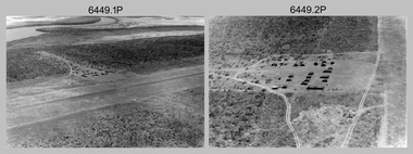
Photograph - RA Svy Project C4 Aerodist Operation, Eastern & Western Arnhem Land, NT, 1967, 1968
... RA Svy Project C4 Aerodist Operation, Eastern & Western Arnhem Land, NT...RA Svy Project C4 Aerodist Operation, Eastern & Western Arnhem Land, NT...This is a set of 26 photographs of Royal Australian Survey Corps (RA Svy) personnel from Central Comd Fd Svy Unit (Adelaide) on Aerodist survey operation - Project C4 in Eastern Arnhem Land, Northern Territory in 1967 (photos .4P to .26P) and in Western Arnhem Land, Northern Territory in 1968 (photos .1P to .3P). ...This is a set of 26 photographs of Royal Australian Survey Corps (RA Svy) personnel on Aerodist survey operations in Eastern Arnhem Land, Northern Territory in 1967 and Western Arnhem Land, Northern Territory in 1968. ...Gove, Eastern Arnhem Land, NT...Bendigo Military Museum 37 - 39 Pall Mall Bendigo goldfields This is a set of 26 photographs of Royal Australian Survey Corps (RA Svy) personnel from Central Comd Fd Svy Unit (Adelaide) on Aerodist survey operation - Project C4 in Eastern Arnhem Land, Northern Territory in 1967 (photos .4P to .26P) and in Western Arnhem Land, Northern Territory in 1968 (photos .1P to .3P). ...This is a set of 26 photographs of Royal Australian Survey Corps (RA Svy) personnel from Central Comd Fd Svy Unit (Adelaide) on Aerodist survey operation - Project C4 in Eastern Arnhem Land, Northern Territory in 1967 (photos .4P to .26P) and in Western Arnhem Land, Northern Territory in 1968 (photos .1P to .3P). Photos of personnel were taken either at the operations base at Numbulwar or the main base at Gove (Nhulunbuy). RA Svy conducted nineteen Aerodist operations for 12 years from 1964 to 1975. Aerodist MRC2 was a tellurometer-based system adapted for aircraft to accurately measure distances between non-intervisible ground survey stations, using the aircraft as an intermediate station. Lower order geodetic results could be achieved by survey network trilateration. The measured distances between stations formed survey networks from which each station’s latitude and longitude was computed. Aerodist MRC2 was RA Svy’s major horizontal control survey tool for mainly medium scale topographic mapping (scale 1:100,000 Class A being spatially accurate to within 50 metres) in PNG, northern NT, north-west WA, Kalimantan Barat (West) Indonesia, Sumatra Indonesia, Gulf of Carpentaria and Cape York, QLD. In 1967, the Aerodist MRC2 Master equipment was installed in the aircraft featured in this set of photos, Executive Air Services’ (Essendon VIC) Grand Aero Commander VH-EXX. It was the same aircraft type and company contracted to Division of National Mapping for Aerodist MRC2 surveys. From July to October 1967 the aircraft was attached to Central Comd Fd Svy Unit (Adelaide - Major Don Ridge) on Project C4 eastern-Arnhem Land NT, where 317 Aerodist lines measuring 17,300 line miles were successfully completed. This was the most productive Aerodist project thus far. The most common helicopter used by RA Svy up to 1972 was the civilian Bell 47G-2 and the Sioux Light Observation Helicopters (LOH), the Australian Army’s equivalent featured in this photo set. These light observation helicopters had a limiting load carrying capacity of up to about 500 pounds. By comparison, one Aerodist team including two people weighed up to 1,500 pounds. In 1968, after completion of the Kimberley Aerodist Operation project, the Aerodist system in VH-EXX was immediately deployed to western-Arnhem Land NT for Central Comd Fd Svy Unit (Adelaide - Major Don Ridge) to complete the mapping control across northern NT from mid-July to October. The Aerodist MRC2 Remote antenna seen in Photos .24P to .26P is mounted on a 20 foot pole tower. The antenna direction was controlled by wires/ropes to the two arms under the dish at right angles. The antenna elevation could be changed to the vertical for aircraft height checks as seen in photo .25P. Source: Royal Australian Survey Corps – Aerodist Years 1964-1975 by Peter Jensen. Refer to Item 6449.30P for more photos taken during these Aerodist survey operations.This is a set of 26 photographs of Royal Australian Survey Corps (RA Svy) personnel on Aerodist survey operations in Eastern Arnhem Land, Northern Territory in 1967 and Western Arnhem Land, Northern Territory in 1968. The photographs are on 35mm negative film and scanned at 96 dpi. They are part of the Army Survey Regiment’s Collection. .1) to .2) – Photo, black & white, 1968, unidentified soldier with an opened can of food, possibly bully beef. .3) – Photo, black & white, 15 Aug 1968, aerial view of terrain taken from a helicopter in vicinity of MILINGIMBI SIERRA. .4) – Photo, black & white, 1967, aerial view of an island taken from a helicopter. .5) & .6) – Photo, black & white, 1967, unidentified soldier driving a Haflinger 4x4 Light utility vehicle with trailer. .7) – Photo, black & white, 1967, unidentified surveyors taking vertical measurements with a leveling instrument and staff. .8) – Photo, black & white, 1967, Australian Army Sioux Light Observation Helicopter (LOH) with float removed. .9) to .11) – Photo, black & white, 1967, Australian Army Sioux Light Observation Helicopter (LOH) with floats. .12) – Photo, black & white, 1967, civilian Bell 47G-2 helicopter (Australian Army Sioux LOH equivalent) refuelled. .13) – Photo, black & white, 1967, survey station on coastline surrounded by white plastic aerial photographic identification panels lined with rocks. .14) & .15) – Photo, black & white, 1967, soldier (possibly a signaller from RA Sigs) operating a radio. .16) – Photo, black & white, 1967, Central Comd Fd Svy Unit Operations Section tent, Main Base Gove (Nhulunbuy) L to R: SPR Harry Dunn, WO1 Pat Wood BEM. .17) – Photo, black & white, 1967, Central Comd Fd Svy Unit Operations Section tent, Main Base Gove (Nhulunbuy) L to R: unidentified, WO1 Pat Wood BEM. .18) – Photo, black & white, 1967, Central Comd Fd Svy Unit Operations Section, Main Base Gove (Nhulunbuy), unidentified Australian Army Catering Corps cook preparing meals. .19) – Photo, black & white, 1967, Central Comd Fd Svy Unit Operations Section, Main Base Gove (Nhulunbuy) mess tent in readiness for meals. .20) – Photo, black & white, 1967, Bank of batteries in transit boxes undergoing recharging using generators. .21) – Photo, black & white, 1967, A topographic survey identification plaque set in a concrete block being weighed using a set of scales hanging from slaughtering gallows. .22) – Photo, black & white, 1967, CPL (Geoff or Gary) Larkin operating the remote Aerodist MRC2 ground instrument at Veronica Island, located north of Nhulunbuy. .23) – Photo, black & white, 1967, L to R: CPL (Geoff or Gary) Larkin with unidentified surveyor operate the remote Aerodist MRC2 ground instrument at Venica Island, located north of Nhulunbuy. .24) & .25 – Photo, black & white, 1967, The Aerodist MRC2 Remote antenna. .26) – Photo, black & white, 1967, The Aerodist MRC2 Remote antenna.The following photos are annotated in black ink on edge of film negative: .3P – ’15 Aug ’68, 2000’, 1-C18 ’68 MILINGIMBI SIERRA’ .4P – ’U462’ .8P – ‘1-C3/67 Float Removed’ .13P – ‘U477 10-C3/67 .20P - ‘2-C3/67 Bank of Chargers’ .21P - ‘3-C3/67 Gallows & Scales’ .22P - ‘0462 VERONICA ISLAND NT, CPL Larkin’ .23P - ‘0462 VERONICA ISLAND NT’ .24P - ‘4-C3/67 20’ Aerodist Tower’ .25P - ‘5-C3/67 20’ Aerodist Tower’ .26P - ‘6-C3/67 20’ Aerodist Tower’royal australian survey corps, rasvy, army survey regiment, army svy regt, fortuna, asr, aerodist, surveying, central comd fd svy unit -
 Phillip Island and District Historical Society Inc.
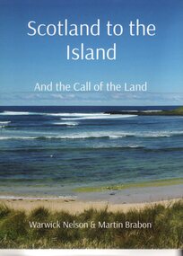
Book, Warwick Nelson & Martin Brabon, Scotland to the Island. And the call of the land, 2022
... And the call of the land....Robert Miller selected land in Ventnor in 1868. His daughter, Catherine, later lived nearby with the neighbouring bay named after her, Kitty Miller Bay....Book - Scotland to the Island and the call of the land. Large Book...Scotland to the Island. and the call of the land. Warwick Nelson & Martin Brabon...And the call of the land. Book Warwick Nelson & Martin Brabon ...The Miller family were one of the early settlers on Phillip Island. Robert Miller selected land in Ventnor in 1868. His daughter, Catherine, later lived nearby with the neighbouring bay named after her, Kitty Miller Bay.HistoricalBook - Scotland to the Island and the call of the land. Large BookScotland to the Island. and the call of the land. Warwick Nelson & Martin Brabonmiller family, kitty miller bay phillip island, catherine walker (nee kitty miller), warwick nelson, robert miller, farming, ventnor -
Lakes Entrance Historical Society
Book, Land Conservation Council Victoria, Land Conservation Council East Gippsland Area Review, 1985
... Land Conservation Council East Gippsland Area Review...Report describing the physical and biological aspects of the public land in the eastern corner of Victoria, predominantly the Orbost Shire. ...Land Conservation Council Victoria...Many issues are covered in the report, including timber industry, national parks, waterways and tourism. Six maps Land Conservation Council East Gippsland Area Review Book Land Conservation Council Victoria ...Report describing the physical and biological aspects of the public land in the eastern corner of Victoria, predominantly the Orbost Shire. Many issues are covered in the report, including timber industry, national parks, waterways and tourism. Six mapsparks, waterways, tourism, gippsland -
University of Melbourne, Burnley Campus Archives
Magazine - Journal articles, Melbourne School of Land and Environment et al, Land & Environment, 2013
... Land & Environment...The Melbourne School of Land and Environment Magazine, Winter 2013. ...Melbourne School of Land and Environment...Welcome Back, Sugar by Megan Backhouse p 14. - Sugar Gum table and Chairs (originally appeared in The Age) Land & Environment Magazine Journal articles Melbourne School of Land and Environment Nerissa Hannink Megan Backhouse ...green roofs, sugar table -
 Bendigo Military Museum
Photograph - RA Svy Project C4 Aerodist Operation, Eastern Arnhem Land, NT, 1967
... RA Svy Project C4 Aerodist Operation, Eastern Arnhem Land, NT...RA Svy Project C4 Aerodist Operation, Eastern Arnhem Land, NT...This is a set of 30 photographs of Royal Australian Survey Corps (RA Svy) personnel from Central Comd Fd Svy Unit (Adelaide) on Aerodist survey operation - Project C4 in Eastern Arnhem Land, Northern Territory in 1967. Photos of personnel were taken either at the operations base at Numbulwar or the main base at Gove (Nhulunbuy). ...This is a set of 30 photographs of Royal Australian Survey Corps (RA Svy) personnel on Aerodist survey operations in Eastern Arnhem Land, Northern Territory in 1967. The photographs are on 35mm negative film and scanned at 96 dpi. ...Gove, Eastern Arnhem Land, NT...RA Svy Project C4 Aerodist Operation, Eastern Arnhem Land, NT Photograph RA Svy Project C4 Aerodist Operation, Eastern Arnhem Land, NT Army Survey Regiment ...This is a set of 30 photographs of Royal Australian Survey Corps (RA Svy) personnel from Central Comd Fd Svy Unit (Adelaide) on Aerodist survey operation - Project C4 in Eastern Arnhem Land, Northern Territory in 1967. Photos of personnel were taken either at the operations base at Numbulwar or the main base at Gove (Nhulunbuy). RA Svy conducted nineteen Aerodist operations for 12 years from 1964 to 1975. Aerodist MRC2 was a tellurometer-based system adapted for aircraft to accurately measure distances between non-intervisible ground survey stations, using the aircraft as an intermediate station. Lower order geodetic results could be achieved by survey network trilateration. The measured distances between stations formed survey networks from which each station’s latitude and longitude was computed. Aerodist MRC2 was RA Svy’s major horizontal control survey tool for mainly medium scale topographic mapping (scale 1:100,000 Class A being spatially accurate to within 50 metres) in PNG, northern NT, north-west WA, Kalimantan Barat (West) Indonesia, Sumatra Indonesia, Gulf of Carpentaria and Cape York, QLD. In 1967, the Aerodist MRC2 Master equipment was installed in the aircraft featured in this set of photos, Executive Air Services’ (Essendon VIC) Grand Aero Commander VH-EXX. It was the same aircraft type and company contracted to Division of National Mapping for Aerodist MRC2 surveys. From July to October 1967 the aircraft was attached to Central Comd Fd Svy Unit (Adelaide - Major Don Ridge) on Project C4 eastern-Arnhem Land NT, where 317 Aerodist lines measuring 17,300 line miles were successfully completed. This was the most productive Aerodist project thus far. The most common helicopter used by RA Svy up to 1972 was the civilian Bell 47G-2 and the Sioux Light Observation Helicopters (LOH), the Australian Army’s equivalent featured in this photo set. These light observation helicopters had a limiting load carrying capacity of up to about 500 pounds. By comparison, one Aerodist team including two people weighed up to 1,500 pounds. Source: Royal Australian Survey Corps – Aerodist Years 1964-1975 by Peter Jensen. Refer to Item 9061.26P for more photos taken during this Aerodist survey operation.This is a set of 30 photographs of Royal Australian Survey Corps (RA Svy) personnel on Aerodist survey operations in Eastern Arnhem Land, Northern Territory in 1967. The photographs are on 35mm negative film and scanned at 96 dpi. They are part of the Army Survey Regiment’s Collection. .1) to .4) - black & white, 20th August 1967, Project C4 Aerodist Operations Base - Numbulwar, NT. .5) - Photo, black & white, 1967. Probable wrecked Indonesian fishing vessel. .6) to .8) - Photo, black & white, 1967. Unidentified survey operations base, L to R: unidentified personnel. .9) - Photo, black & white, 1967. Unidentified survey operations base, unidentified soldier driving a Haflinger 4x4 Light utility vehicle. .10) - Photo, black & white, 1967. Unidentified survey operations base, L to R: unidentified technician. .11) - Unidentified technician reading two survey altimeters to compute corrections to the measured distances for atmospheric refraction and to compute the sea level distances from the slope distances aircraft to the ground stations. .12) - Photo, black & white, 1967. Survey operations base, L to R: unidentified (x3), W01 Pat Wood BEM, unidentified. .13) to .16) - Photo, black & white, 1967. Unidentified personnel operating remote Aerodist MRC2 ground instruments. .17) to .18) - Photo, black & white, 1967. Unknown RA Svy office location. .19) to .20) - Photo, black & white, 1967. Aerodist MRC2 Master equipment. .21) to .22) - Photo, black & white, 1967. Aero Commander VH-EXX probably at Gove, NT, Central Comd Fd Svy Unit (Adelaide) – OC Major Don Ridge. .23) to .25) - Photo, black & white, 1967. Aero Commander VH-EXX probably at Gove, NT. Unidentified personnel. .26) - Photo, black & white, 1967. Aero Commander VH-EXX probably at Gove, NT. Aerodist antenna pods are visible on the aircraft. .27) to .29) - Photo, black & white, 1967. Australian Army Sioux Light Observation Helicopter (LOH) probably at Gove, NT. .30) - Photo, black & white, 1967. Panelled U337 survey station, visible as a white cross on aerial identification photo..1P to .2P – date and location on edge of film negative. .5P to .28P – no annotations .29P - annotated in white ‘RW-JEP Gove NT’ .30P - annotated in white ‘U337 Spool No1 Jun67’royal australian survey corps, rasvy, army survey regiment, army svy regt, fortuna, asr, aerodist, surveying, central comd fd svy unit -
 Greensborough Historical Society
Business card, Health Land, 2019_
... Health Land...Health Land is a health and wellness massage service, located at 3/83 Main Street Greensborough...Health Land...Greensborough Historical Society 34A Glenauburn Road Lower Plenty Lower Plenty melbourne Health Land is a health and wellness massage service, located at 3/83 Main Street Greensborough Part of a collection relating to local businesses. health main street greensborough Telephone no., address and services information Printed in green and orange on white card, on both sides Health Land Business card Health Land ...Health Land is a health and wellness massage service, located at 3/83 Main Street GreensboroughPart of a collection relating to local businesses.Printed in green and orange on white card, on both sidesTelephone no., address and services informationhealth, main street greensborough -
University of Melbourne, Burnley Campus Archives
Book, Lindsay Falvey, Land and Food: Agricultural and Related Education in the Victorian Colleges, 1997
... Land and Food: Agricultural and Related Education in the Victorian Colleges......institute of land & food resources...Book written by Lindsay Falvey and Barrie Beardsley published by the Institute of Land & Food Resources, The University of Melbourne, 1997.......Institute of Land & Food Resources, The University of Melbourne...University of Melbourne, Burnley Campus Archives 500 Yarra Boulevard Richmond melbourne Book written by Lindsay Falvey and Barrie Beardsley published by the Institute of Land & Food Resources, The University of Melbourne, 1997. lindsay falvey barrie beardsley institute of land & food resources university of melbourne 1997 burnley horticultural college Land and Food: Agricultural and Related Education in the Victorian Colleges Book Book Lindsay Falvey Institute of Land & Food Resources, The University of Melbourne ...Book written by Lindsay Falvey and Barrie Beardsley published by the Institute of Land & Food Resources, The University of Melbourne, 1997.lindsay falvey, barrie beardsley, institute of land & food resources, university of melbourne, 1997, burnley horticultural college -
Koorie Heritage Trust
Book, Aboriginal Land Commissioner, Aboriginal Land Commissioner Report. Aboriginal Land Rights ( Northern Territory ) Act 1976 : Annual report, 1976
... Aboriginal Land Commissioner Report. Aboriginal Land Rights ( Northern Territory ) Act 1976 : Annual report....Aboriginal Land Rights ( Northern Territory ) Act 1976 -- Aboriginal Land Commissioner...Aboriginal Land Commissioner...Koorie Heritage Trust Levels 1 & 3, Yarra Building Federation Square, Melbourne melbourne Aboriginal Land Rights ( Northern Territory ) Act 1976 -- Aboriginal Land Commissioner Aboriginal Land Commissioner Report. ...aboriginal land rights ( northern territory ) act 1976 -- aboriginal land commissioner -
 Bacchus Marsh & District Historical Society
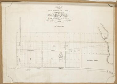
Map, Atkins and Clarke Land Sale situate at Bacchus Marsh 1856 Copy 2
... Atkins and Clarke Land Sale situate at Bacchus Marsh 1856 Copy 2...Land Sales...This plan of land allotments for sale indicates the property once owned by the Bacchus family in and around the township area of Bacchus Marsh. ...A single page paper map showing a portions of land available for sale in Bacchus Marsh in 1856. ...Plan of the first portion of land. The property of Messers Atkins and Clarke situate at Bacchus Marsh....Upon seeing the map in 1911 Bacchus Marsh Express newspaper editor Christopher Crisp wrote "The sale appears to have created the present township, which had a nucleus in earlier times further east", Express, 30 September, 1911, page 3. Land Sales Land Sales Bacchus Marsh Manor House Bacchus Marsh Crook Family Bacchus Marsh Plan of the first portion of land. ...This plan of land allotments for sale indicates the property once owned by the Bacchus family in and around the township area of Bacchus Marsh. The Bacchus family sold their property in Bacchus Marsh to John Atkins and Robert Nalder Clarke in March 1851. Atkins and Clarke kept the property for a number of years until April 1856 when these allotments were put up for sale.This plan is almost identical to another copy held by the Bacchus Marsh and District Historical Society, VC Record 707, BMDHS collection). This plan, VC Record 452 Copy 2, contains a less detail than than VC Record 707 Copy 1. For example the selling agents and the surveyor who created the plan are not indicated on this copy of the plan. This copy of the plan does indicate the name Crook Street on the map. As the Crook family were the buyers of the Manor House property and surrounding land from Atkins and Clarke in 1856 it suggests that this copy is a later one of the earlier version. It is unlikely that the Crook family would have had the adjacent street named after them prior to purchasing the house and property. This is a very early land sales plan for the township of Bacchus Marsh and it therefore provides some clues as to how the early urban development of the township took place. Upon seeing the map in 1911 Bacchus Marsh Express newspaper editor Christopher Crisp wrote "The sale appears to have created the present township, which had a nucleus in earlier times further east", Express, 30 September, 1911, page 3. A single page paper map showing a portions of land available for sale in Bacchus Marsh in 1856. The subdivided land shown was owned by John Atkins and Robert Nalder Clarke, but previously owned by the Bacchus Family and was in and around their Manor House (Mansion) property in Bacchus Marsh.There are 5 portions of land further divided into numerous small portions. The land for sale is bounded by the present day streets of Main Street, Young Street, McFarland Street, Morton Streets, Crook Street, and part of the eastern section extends to the Lerderderg River. Scale: 4 chains to 1 inch. The map is pasted into a bound volume containing 76 maps or plans in total. High resolution digital image stored on BMDHS computer network. Plan of the first portion of land. The property of Messers Atkins and Clarke situate at Bacchus Marsh.land sales, land sales bacchus marsh, manor house bacchus marsh, crook family bacchus marsh -
 Bendigo Military Museum
Souvenir - Souvenir Booklet of Land Headquarters Cartographic Company, Australian Survey Corps "Fortuna" Bendigo 1942-45, Land Headquarters Cartographic Company, Australian Survey Corps, 1945
... Souvenir Booklet of Land Headquarters Cartographic Company, Australian Survey Corps "Fortuna" Bendigo 1942-45....Souvenir Booklet of Land Headquarters Cartographic Company, Australian Survey Corps "Fortuna" Bendigo 1942-45....A Souvenir Booklet recording the Section photos and a Nominal roll of those who served 1942-45 at the Land Headquarters Cartographic Company, Australian Survey Corps located at "Fortuna Villa" Bendigo was produced at the end of WWII. ...Land Headquarters Cartographic Company, Australian Survey Corps...Land Headquarters Cartographic Company, Australian Survey Corps ...A Souvenir Booklet recording the Section photos and a Nominal roll of those who served 1942-45 at the Land Headquarters Cartographic Company, Australian Survey Corps located at "Fortuna Villa" Bendigo was produced at the end of WWII. Each member of the unit was presented with a copy of the booklet. The booklet besides being a great memory for those who served is a very valuable resource as it names the individuals in the photographs and very importantly records a Nominal Roll of unit members and their Military details. This booklet is one of those original booklets. The booklet has been reprinted on a number of occasions with different coloured covers. The first and original booklet had a red cover. Editions with brown, dark blue and black exist. The black covered edition was the last reprint. This booklet was donated by Carol Hargrave of Grenfell, NSW after discovering it in an old trunk that she purchased. A black covered edition was donated by a local Bendigo Antique Dealer in September 2024.A4 sized red cloth covered hard covered book mainly containing sub-unit photographs of section members and includes their names. 23 x double sided pages of photographs and 2 double sided pages of a Nominal Roll of those who served at Fortuna 1942 - 45. Each of the 50 pages were scanned at 600 dpi in JPEG (.jpg) format and stored on the attached 16GB USB Memory Stick. The images have been converted into MPEG-4 (.mp4) video format, 9Mb in size that runs for 4 Minutes and is also stored on the memory stick.royal australian survey corps, rasvy, fortuna, army survey regiment, army svy regt, asr -
 National Wool Museum
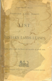
Book, NSW Western Land Board: list of western land leases 1909
... NSW Western Land Board: list of western land leases 1909......land enclosure...NSW Western Land Board: list of Western Land Leases, 1909...Australian Mercantile Land and Finance Co Ltd annotations...National Wool Museum 26 Moorabool Street Geelong geelong-and-the-bellarine-peninsula NSW Western Land Board: list of Western Land Leases, 1909 land enclosure pastoral industry - settlement sheep stations - history nsw western land board land enclosure pastoral industry - settlement sheep stations - history Australian Mercantile Land and Finance Co Ltd annotations NSW Western Land Board: list of western land leases 1909 Book Book ...NSW Western Land Board: list of Western Land Leases, 1909Australian Mercantile Land and Finance Co Ltd annotationsland enclosure pastoral industry - settlement sheep stations - history, nsw western land board, land enclosure, pastoral industry - settlement, sheep stations - history -
 Greensborough Historical Society
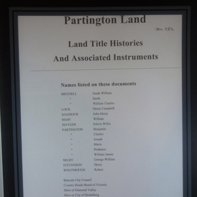
Folder of Documents, Partington land: Land Title Histories and Associated Instruments, 1826o
... Partington land: Land Title Histories and Associated Instruments...Land title documents trace the ownership of land owned by the Partington family of Greensborough....Folder of copies of land title documents. 36 pages. ...Greensborough Historical Society 34A Glenauburn Road Lower Plenty Lower Plenty melbourne Land title documents trace the ownership of land owned by the Partington family of Greensborough. ...Land title documents trace the ownership of land owned by the Partington family of Greensborough.The Partington family are Greensborough pioneers and have lived in the area since the 1840s.Folder of copies of land title documents. 36 pages. partington, plenty river, banyule city council, shire of heidelberg, shire of diamond valley -
Whitehorse Historical Society Inc.
Document, Robert Collier Land, 1903
... Robert Collier Land...Morton & Coghill 10 Aug 1903; statement and receipt from Maddock & Jamison for services relating to above sale and to purchase of land in Tunstall from Freehold Investment Company 6 Nov 1903....Papers relating to land dealings by Robert Collier of Springvale Road Tunstall. ...Morton & Coghill 10 Aug 1903; statement and receipt from Maddock & Jamison for services relating to above sale and to purchase of land in Tunstall from Freehold Investment Company 6 Nov 1903....Robert Collier Land Document Document ...50 acres and house in Canterbury Road Blackburn to I.N. Cuttle for (pounds)590Papers relating to land dealings by Robert Collier of Springvale Road Tunstall. 50 acres and house in Canterbury Road Blackburn to I.N. Cuttle for (pounds)590collier, robert, t.r.b morton & coghill, maddock & jamison, canterbury road blackburn, freehold investment company of australia ltd -
4th/19th Prince of Wales's Light Horse Regiment Unit History Room
Book, Joseph Wones Ltd, Land Rover Series IIA Owner's Manual, Oct 1962
... Land Rover Series IIA Owner's Manual......Land Rover...Soft covered owner's manual for the Land Rover Series II A....Land Rover Series IIA Part No 4482 'Regular', 'Long' and Forward Control Owner's Manual ...4th/19th Prince of Wales's Light Horse Regiment Unit History Room 4/19 PWLH Regiment, Building 78 Simpson Barracks Macleod melbourne Manual for vehicles used by the Regiment User manual Land Rover Land Rover Series IIA Part No 4482 'Regular', 'Long' and Forward Control Owner's Manual Soft covered owner's manual for the Land Rover Series II A. ...Manual for vehicles used by the RegimentSoft covered owner's manual for the Land Rover Series II A.Land Rover Series IIA Part No 4482 'Regular', 'Long' and Forward Control Owner's Manual user manual, land rover -
Whitehorse Historical Society Inc.
Article, Rating on unimproved land values, 1911
... Rating on unimproved land values....Complaining about the difference between rating of unimproved land and improved land....Complaining about the difference between rating of unimproved land and improved land....Rating on unimproved land values. Article Article ...A letter from 'Ratepayer' in the Open Column of the Reporter (Box Hill).A letter from 'Ratepayer' in the Open Column of the Reporter (Box Hill) .A letter from 'Ratepayer' in the Open Column of the Reporter (Box Hill). shire of nunawading, mitcham road mitcham, whitehorse road mitcham, station street mitcham -
Emerald Museum & Nobelius Heritage Park
Map - Land Capability Study of the Shire of Cardinia, parish of Emerald, c1996
... Land Capability Study of the Shire of Cardinia, parish of Emerald...Land Capability Study of the Shire of Cardinia, parish of Emerald...Image of a land capability study map in the Shire of Cardinia, parish Parcels of Emerald...A land Capability Study of the Shire of Cardinia/Map Units and Parish parcels of Emerald/C1996...Emerald Museum & Nobelius Heritage Park 5 Crichton Rd Emerald yarra-valley-and-the-dandenong-ranges A land Capability Study of the Shire of Cardinia/Map Units and Parish parcels of Emerald/C1996 Image of a land capability study map in the Shire of Cardinia, parish Parcels of Emerald Land Capability Study of the Shire of Cardinia, parish of Emerald Map Land Capability Study of the Shire of Cardinia, parish of Emerald ...Image of a land capability study map in the Shire of Cardinia, parish Parcels of EmeraldA land Capability Study of the Shire of Cardinia/Map Units and Parish parcels of Emerald/C1996 -
 Ringwood and District Historical Society
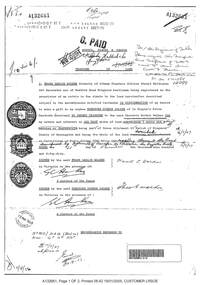
Document, Property Research Notes - Reaghill, Ringwood East, Victoria. Appendix 10 - Transfer of Land - F.L. Walker to T.G. Walker and Wombalano Park
... Appendix 10 - Transfer of Land - F.L. Walker to T.G. Walker and Wombalano Park....Photocopies of A4 Titles Office printouts identifying land included and excluded in Wombalano Park land gifted to the Mayor, Councillors and Burgesses of the Borough of Ringwood...I, Frank Leslie Walker formerly of Albany Chambers, Collins Street Melbourne, Art Decorator, now of Bedford Road Ringwood, Gentleman, being registered as the proprietor of an estate in fee simple in the land hereinafter described subject to the encumbrances notified hereunder in consideration of desire to make a gift to my nephew Theodore Gordon Walker of 14 Coppins Grove Hawthorn, Secretary, do hereby transfer ... all that piece of land containing 5 acres and 4 perches or thereabouts being part of Crown Allotment 43, Parish of Ringwood County of Mornington, and being the whole of the land described in Certificate of Title Volume 3780 Folio 948 excepting the land transferred by Instrument of Transfer No. 2710154 in the Register Book. ...I, Frank Leslie Walker formerly of Albany Chambers, Collins Street Melbourne, Art Decorator, now of Bedford Road Ringwood, Gentleman, being registered as the proprietor of an estate in fee simple in the land hereinafter described subject to the encumbrances notified hereunder in consideration of desire to make a gift to my nephew Theodore Gordon Walker of 14 Coppins Grove Hawthorn, Secretary, do hereby transfer ... all that piece of land containing 5 acres and 4 perches or thereabouts being part of Crown Allotment 43, Parish of Ringwood County of Mornington, and being the whole of the land described in Certificate of Title Volume 3780 Folio 948 excepting the land transferred by Instrument of Transfer No. 2710154 in the Register Book. ...Photocopies of A4 Titles Office printouts identifying land included and excluded in Wombalano Park land gifted to the Mayor, Councillors and Burgesses of the Borough of RingwoodI, Frank Leslie Walker formerly of Albany Chambers, Collins Street Melbourne, Art Decorator, now of Bedford Road Ringwood, Gentleman, being registered as the proprietor of an estate in fee simple in the land hereinafter described subject to the encumbrances notified hereunder in consideration of desire to make a gift to my nephew Theodore Gordon Walker of 14 Coppins Grove Hawthorn, Secretary, do hereby transfer ... all that piece of land containing 5 acres and 4 perches or thereabouts being part of Crown Allotment 43, Parish of Ringwood County of Mornington, and being the whole of the land described in Certificate of Title Volume 3780 Folio 948 excepting the land transferred by Instrument of Transfer No. 2710154 in the Register Book. -
Ringwood and District Historical Society
Land titles and plan, Victorian Titles Office, Titles and plans of Ringwood Land between Mullum Land and Wonga Rd. (Re Ann Jane Kennedy). 1907, 1-Oct-07
... Land titles and plan...Titles and plans of Ringwood Land between Mullum Land and Wonga Rd. (Re Ann Jane Kennedy). 1907...The documents pertaining to Ann Jane Kennedy inheriting the land from her late husband Samuel John Kennedy and the history of the transfers of land from Ann Jane Kennedy in 1907 until the title was cancelled in 1925 to James Melbourne Ross. ...Ten pages of photocopied titles and plans of land in Ringwood between Mullum Road and Wonga Road, also transfer of original land....Titles and plans of Ringwood Land between Mullum Land and Wonga Rd. (Re Ann Jane Kennedy). 1907 Land titles and plan Victorian Titles Office ...The documents pertaining to Ann Jane Kennedy inheriting the land from her late husband Samuel John Kennedy and the history of the transfers of land from Ann Jane Kennedy in 1907 until the title was cancelled in 1925 to James Melbourne Ross. The area was 10 acres between Mullum Mullum Road and Wonga Road retrieved from Titles Office.Ten pages of photocopied titles and plans of land in Ringwood between Mullum Road and Wonga Road, also transfer of original land. -
 Emerald Museum & Nobelius Heritage Park
Map - Sales Flyer for 80 blocks of land in the region of Black Hill Parade, Selby on January 31, 1927, Public Auction, 80 blocks of land, Monday Jan.31, 1927, land adjacent to Black Hill Parade, Selby, c1927
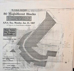
... Sales Flyer for 80 blocks of land in the region of Black Hill Parade, Selby on January 31, 1927...Public Auction, 80 blocks of land, Monday Jan.31, 1927, land adjacent to Black Hill Parade, Selby...Land sale by auction of property in Selby 1927...By Public Auction/80 Magnificent Blocks/The Vendors are good sellers and the land offered is at first hand prices and values will rise considerably. ...Day, Monday, Jan.31, 1927/At three p.m. in a seated Marquee, on the Estate/Buy now for future profit/Solicitors for the Estate, Messrs, Maddock, Jamieson & Lonie, 136 Queen St., Melbourne/easy terms 1 pound deposit, 1 pound monthly, interest 6 per cent per annum Image of Public Auction flyer on Jan31, 1927, 80 blocks in the vicinity of Black Hill Parade, Selby Public Auction, 80 blocks of land, Monday Jan.31, 1927, land adjacent to Black Hill Parade, Selby Map Sales Flyer for 80 blocks of land in the region of Black Hill Parade, Selby on January 31, 1927 ...Image of Public Auction flyer on Jan31, 1927, 80 blocks in the vicinity of Black Hill Parade, Selby -
Lakes Entrance Historical Society
Book, Land Conservation Council, Proposed Recommendations Alpine Area Land Conservation 1978, 1978
... Proposed Recommendations Alpine Area Land Conservation 1978...Land conservation...Land Conservation Council...Lakes Entrance Historical Society 4 Marine Parade Lakes Entrance gippsland Land conservation Alpine Region recommendations Proposal by Land Conservation Council with recommendations for Alpine Area with maps Soft cover book blue cover with 100 pages Proposed Recommendations Alpine Area Land Conservation 1978 Book Land Conservation Council ...Proposal by Land Conservation Council with recommendations for Alpine Area with mapsSoft cover book blue cover with 100 pagesnon-fictionProposal by Land Conservation Council with recommendations for Alpine Area with mapsland conservation, alpine region, recommendations -
University of Melbourne, Burnley Campus Archives
Booklet, School of Land and Environment, Melbourne School of Land and Environment Postgraduate Conference 2008, 2008
... Melbourne School of Land and Environment Postgraduate Conference 2008......School of Land and Environment...Melbourne School of Land and Environment Postgraduate Conference 2008 Booklet Found in the Cottage, former residence of Poultry Curator in 2019 School of Land and Environment ...postgraduates, conference -
University of Melbourne, Burnley Campus Archives
Administrative record, Andrew Smith et al, University of Melbourne Institute of Land and Food Resources Burnley Campus Gardens Staffing 2003-04, 2003-2005
... University of Melbourne Institute of Land and Food Resources Burnley Campus Gardens Staffing 2003-04......Institute of Land and Food Resources, The University of Melbourne...University of Melbourne Institute of Land and Food Resources Burnley Campus Gardens Staffing 2003-04 Administrative record Andrew Smith Institute of Land and Food Resources, The University of Melbourne ...mainrenance, garden maintenance, property & buildings, staff descriptions, transition -
 Whitehorse Historical Society Inc.
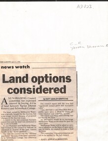
Newspaper - Article, Land options considered, 11/04/1994
... Land options considered...Article from the Gazette, 11 April 1994, on Nunawading Council interest in buying 4.6 ha. of land between Yarran Dheran and Schwerkolt Cottage from Melbourne Water by Katy Ahley- Griffiths....Whitehorse Historical Society Inc. 2-10 Deep Creek Road Mitcham melbourne yarran dheran schwerkolt cottage melbourne water Article from the Gazette, 11 April 1994, on Nunawading Council interest in buying 4.6 ha. of land between Yarran Dheran and Schwerkolt Cottage from Melbourne Water by Katy Ahley- Griffiths. ...Article from the Gazette, 11 April 1994, on Nunawading Council interest in buying 4.6 ha. of land between Yarran Dheran and Schwerkolt Cottage from Melbourne Water by Katy Ahley- Griffiths.yarran dheran, schwerkolt cottage, melbourne water