Showing 1129 items matching "c. north"
-
 B-24 Liberator Memorial Restoration Australia Inc
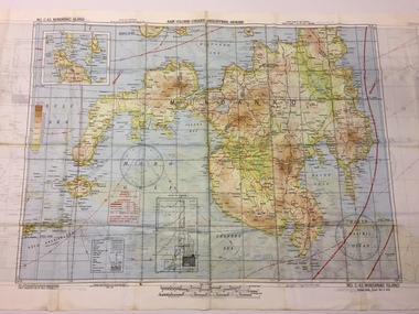
Map - US World War II multi-coloured map - Philippine Series, No. C-43 Mindanao Series, No. C-44 North Borneo, 1944
... C-43 Mindanao Series, No. C-44 North Borneo...C-43 Mindanao Series Side 2 - No. C.44 North Borneo...C-43 Mindanao Series, No. C-44 North Borneo ...Silk and rayon maps were produced by the United States (c. 7.5 million in total), Great Britain (some 1.75 million in total) and Australia during World War II. They were issued to Allied military personnel as part of 'escape and evasion' kits.This map, printed on acetate rayon, is an original US 'escape and evasion' kit map from World War II.A multi-coloured, contoured, double-sided map printed on acetate rayon AAF Cloth Chart - Philippine Series Side 1 - No. C-43 Mindanao Series Side 2 - No. C.44 North Borneounited states of america, silk and rayon maps, world war ii -
 Eltham District Historical Society Inc
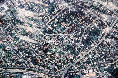
Slide - Photograph, Aerial Photo (c.1987): Montmorency, north of railway, c.Aug. 1990
... Aerial Photo (c.1987): Montmorency, north of railway...In the byways category are views of some iof the Shire's bicycle paths including then recently completed sections of the Main Yarra Trail at Lower Plenty. infrastructure roads aerial photographs montmorency 35mm colour positive transparency (1 of 37) Mount - Agfachrome Agfa CS System black 8 dots Aerial Photo (c.1987): Montmorency, north of railway Slide Photograph ...Part of a presentation, "Roads and Byways of the Shire of Eltham", by Russell Yeoman to the 12 September 1990 Society meeting. Slides shown included copies of old photos and recent images ranging from the suburban streets of Eltham and Montmorency to the mountain roads of Kinglake. In the byways category are views of some iof the Shire's bicycle paths including then recently completed sections of the Main Yarra Trail at Lower Plenty.35mm colour positive transparency (1 of 37) Mount - Agfachrome Agfa CS System black 8 dotsinfrastructure, roads, aerial photographs, montmorency -
 Eltham District Historical Society Inc
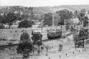
Photograph, Single Motor Carriage (Red Rattler) Tait train on its way to Hurstbridge, near Wattletree Road, Eltham North, c.1970, 1970
... Single Motor Carriage (Red Rattler) Tait train on its way to Hurstbridge, near Wattletree Road, Eltham North, c.1970...View appears to be from near Coolabah Drive looking northwest across parts of Edendale Farm and to the oval near the present day Adventure Playground and Wattletree Road. 471m, edendale farm, eltham north, eltham north adventure playground, george coop collection, red rattler single carriage, single motor carriage, tait train, wattletree road Digital TIFF file Scan of 35mm Ilford HP4 black and white transparency Single Motor Carriage (Red Rattler) Tait train on its way to Hurstbridge, near Wattletree Road, Eltham North, c.1970 Photograph George Coop ...Possibly 471M. View appears to be from near Coolabah Drive looking northwest across parts of Edendale Farm and to the oval near the present day Adventure Playground and Wattletree Road.Digital TIFF file Scan of 35mm Ilford HP4 black and white transparency471m, edendale farm, eltham north, eltham north adventure playground, george coop collection, red rattler single carriage, single motor carriage, tait train, wattletree road -
 Eltham District Historical Society Inc
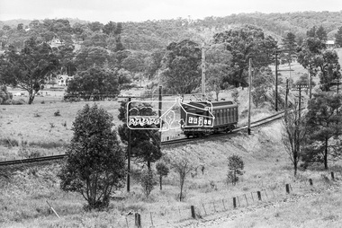
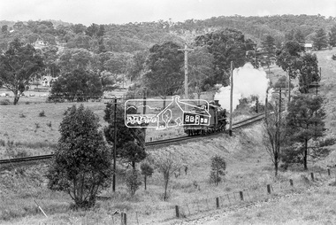
Photograph, Steam locomotive D-639 Vintage train excursion, Hurstbridge to Eltham, near Wattletree Road, Eltham North, c.1970, 1970
... Steam locomotive D-639 Vintage train excursion, Hurstbridge to Eltham, near Wattletree Road, Eltham North, c.1970...As there is no turning table at Hurstbridge, the locomotive would simply shunt from one end of the carriages to the other to reverse direction, hence the locomotive is running in reverse as it approaches Eltham Station. d-639, edendale farm, eltham festival, eltham north, eltham north adventure playground, george coop collection, hurstbridge wattle festival, steam engine, vintage train excursion, wattletree road Digital TIFF file Scan of 35mm Ilford HP4 black and white transparency Steam locomotive D-639 Vintage train excursion, Hurstbridge to Eltham, near Wattletree Road, Eltham North, c.1970 Photograph George Coop ...View appears to be from near Coolabah Drive looking northwest across parts of Edendale Farm and to the oval near the present day Adventure Playground and Wattletree Road. Possibly run in conjunction with the Eltham Community Festival or the Hurstbridge Wattle Festival; the steam train would conduct trips between Eltham and Hurstbridge Railway stations. As there is no turning table at Hurstbridge, the locomotive would simply shunt from one end of the carriages to the other to reverse direction, hence the locomotive is running in reverse as it approaches Eltham Station.Digital TIFF file Scan of 35mm Ilford HP4 black and white transparencyd-639, edendale farm, eltham festival, eltham north, eltham north adventure playground, george coop collection, hurstbridge wattle festival, steam engine, vintage train excursion, wattletree road -
 Eltham District Historical Society Inc
Photograph, Eltham North Primary School viewed from Glen Park Road, Eltham North, c.1983, 1983c
... Eltham North Primary School viewed from Glen Park Road, Eltham North, c.1983...Eltham District Historical Society Inc 728 Main Rd Eltham melbourne Originally contained in a 'magnetic' photo album believed to have been donated by Mr Eric Stephenson, Jingalong, 110 Ryans Road, Eltham, Vic. 3095; relocated to archival safe storage. eltham north eltham north primary school glen park road Colour photograph Eltham North Primary School viewed from Glen Park Road, Eltham North, c.1983 Photograph Photograph ...Originally contained in a 'magnetic' photo album believed to have been donated by Mr Eric Stephenson, Jingalong, 110 Ryans Road, Eltham, Vic. 3095; relocated to archival safe storage.Colour photographeltham north, eltham north primary school, glen park road -
 Eltham District Historical Society Inc
Photograph, Believed to be Eltham North, c.1989, 1989c
... Believed to be Eltham North, c.1989...Eltham District Historical Society Inc 728 Main Rd Eltham melbourne Streetscape evolution houses streets eltham north Fuji 200A Roll of 35mm colour negative film, 6 strips Believed to be Eltham North, c.1989 Photograph ...Streetscape evolutionRoll of 35mm colour negative film, 6 stripsFuji 200Ahouses, streets, eltham north -
 Otway Districts Historical Society
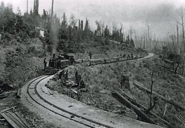
Photograph, Victorian Railways, Beech Forest: From 27 miles 16 chains looking north, c.1901, 1901
... Beech Forest: From 27 miles 16 chains looking north, c.1901...Beech Forest: From 27 miles 16 chains looking north, c.1901 Photograph Victorian Railways ...B/W. 168mm x 246mm. Colac - Beech Forest railway line. From the 27 mile 16 chains line (44.7 km) looking north, between Devitt Bros. Siding (44.1 km) and Ditchley (47 km). On an NA-class locomotive, six NQR wagons, and an open wagon there are workmen throughout. colac; beech forest; railways; devitt bros. siding; ditchley; loco na class -
 Ringwood and District Historical Society
Framed photograph, William Cook Pioneer of Ringwood and Mt Dandenong North c 1914
... William Cook Pioneer of Ringwood and Mt Dandenong North c 1914...Photo of William Cook who was a pioneer in Ringwood and lived in Mt Dandenong North at one time c.1914....Coloured photograph in wooden frame with buff coloured inset +Additional Keywords: Cook, William William Cook Pioneer of Ringwood and Mt Dandenong North c 1914 Framed photograph ...Photo of William Cook who was a pioneer in Ringwood and lived in Mt Dandenong North at one time c.1914.Coloured photograph in wooden frame with buff coloured inset +Additional Keywords: Cook, WilliamBack of frame inscribed William Cook, Pioneer. -
 Eltham District Historical Society Inc
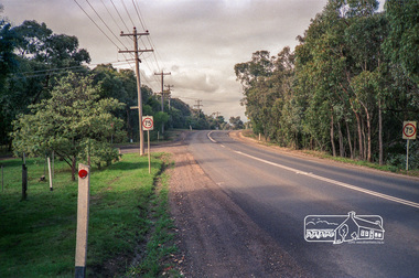
Photograph, Kangaroo Ground-Warrandyte Road, North Warrandyte, c.1988, 1988c
... Kangaroo Ground-Warrandyte Road, North Warrandyte, c.1988...Eltham District Historical Society Inc 728 Main Rd Eltham melbourne Looking southeast, Kruses Road on left. eltham shire council infrastructure Kangaroo Ground-Warrandyte Road Kruses Road North Warrandyte Fuji 100 Roll of 35mm colour negative film, 7 strips Kangaroo Ground-Warrandyte Road, North Warrandyte, c.1988 Photograph ...Looking southeast, Kruses Road on left.Roll of 35mm colour negative film, 7 stripsFuji 100eltham shire council, infrastructure, kangaroo ground-warrandyte road, kruses road, north warrandyte -
 Eltham District Historical Society Inc
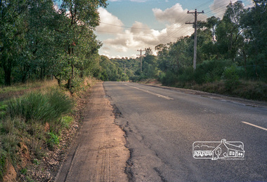
Photograph, Kangaroo Ground-Warrandyte Road, North Warrandyte, c.1988, 1988c
... Kangaroo Ground-Warrandyte Road, North Warrandyte, c.1988...Eltham District Historical Society Inc 728 Main Rd Eltham melbourne Looking northwest. eltham shire council infrastructure kangaroo ground-warrandyte road north warrandyte Fuji 100 Roll of 35mm colour negative film, 7 strips Kangaroo Ground-Warrandyte Road, North Warrandyte, c.1988 Photograph ...Looking northwest.Roll of 35mm colour negative film, 7 stripsFuji 100eltham shire council, infrastructure, kangaroo ground-warrandyte road, north warrandyte -
 Eltham District Historical Society Inc
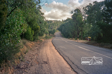
Photograph, Kangaroo Ground-Warrandyte Road, North Warrandyte, c.1988, 1988c
... Kangaroo Ground-Warrandyte Road, North Warrandyte, c.1988...Eltham District Historical Society Inc 728 Main Rd Eltham melbourne Looking northwest. eltham shire council infrastructure kangaroo ground-warrandyte road north warrandyte Fuji 100 Roll of 35mm colour negative film, 7 strips Kangaroo Ground-Warrandyte Road, North Warrandyte, c.1988 Photograph ...Looking northwest.Roll of 35mm colour negative film, 7 stripsFuji 100eltham shire council, infrastructure, kangaroo ground-warrandyte road, north warrandyte -
 Eltham District Historical Society Inc
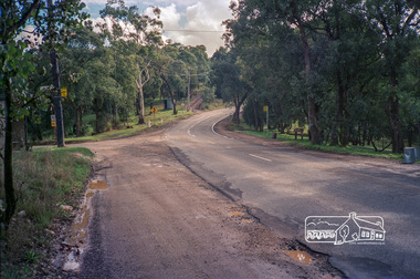
Photograph, Kangaroo Ground-Warrandyte Road, North Warrandyte, c.1988, 1988c
... Kangaroo Ground-Warrandyte Road, North Warrandyte, c.1988...Eltham District Historical Society Inc 728 Main Rd Eltham melbourne Looking northwest, Floods Road on left. eltham shire council infrastructure kangaroo ground-warrandyte road north warrandyte Floods Road Fuji 100 Roll of 35mm colour negative film, 7 strips Kangaroo Ground-Warrandyte Road, North Warrandyte, c.1988 Photograph ...Looking northwest, Floods Road on left.Roll of 35mm colour negative film, 7 stripsFuji 100eltham shire council, infrastructure, kangaroo ground-warrandyte road, north warrandyte, floods road -
 Ringwood and District Historical Society
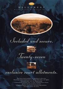
Flyer, Land Sale Advertisement, Hillcrest Heron Court, Ringwood North, Vic. - c.1994
... Land Sale Advertisement, Hillcrest Heron Court, Ringwood North, Vic. - c.1994...Land Sale Advertisement, Hillcrest Heron Court, Ringwood North, Vic. - c.1994 Flyer ...Double sided A4 gloss print advertisement with subdivision map showing location and size of 27 residential allotments and A4 price list page for 14 Lots.Price list includes comment that "construction shall commence in September, with completion in December. Titles Office registration would be expected in January. (No mention of year/s, circa early to mid 1990s). -
 Ringwood and District Historical Society
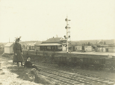
Photograph, Ringwood Railway Station from Station St. looking north west - c.1910
... Ringwood Railway Station from Station St. looking north west - c.1910....Black and white photographs (2 copies - 1 original, 1 copy) Ringwood Railway Station from Station St. looking north west - c.1910. Photograph ...Black and white photographs (2 copies - 1 original, 1 copy)Typed below photograph, "Ringwood Railway Station from Station St. looking north west. Old state school in background at Right. (App. 1910)". -
 Ringwood and District Historical Society
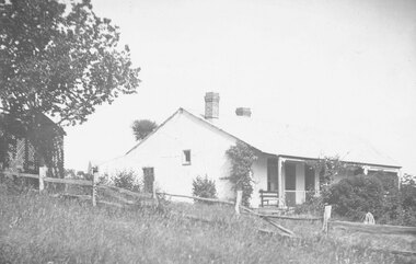
Photograph, "Quambee", North Ringwood c.1912. Four photographs
... "Quambee", North Ringwood c.1912. Four photographs....Black and white photographs (4 images of house) "Quambee", North Ringwood c.1912. Four photographs. Photograph ...Black and white photographs (4 images of house)Written on back of photographs: "Quambee 1912." -
 Bayside Gallery - Bayside City Council Art & Heritage Collection
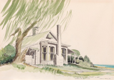
Work on paper - watercolour, John C. Paul, St. Ninian's north elevation c.1841, 1971
... St. Ninian's north elevation c.1841...The property was demolished in 1974. st ninian's brighton historic house george ward cole thomas bent St. Ninian's north elevation c.1841 Work on paper watercolour John C. ...Built around 1841, St Ninian’s, located at 10 Miller Street, was one of Brighton’s earliest buildings. It is best known as being the home of merchant shipping agent, politician and former British naval officer, George Ward Cole between the 1840s and 1902. Following the death of George Ward Cole in 1879 and his wife in 1898, their only surviving child, Margaret, sold the property to Sir Thomas Bent, who subdivided the land in the early 1900s. The property was demolished in 1974. John C. Paul, St. Ninian's north elevation c.1841 1971, watercolour, 29.5 x 42.3 cm. Bayside City Council Art and Heritage Collection. Purchased 1974.st ninian's, brighton, historic house, george ward cole, thomas bent -
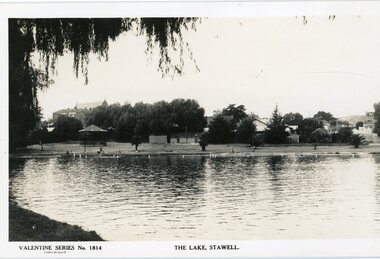 Stawell Historical Society Inc
Photograph, Cato Lake looking North Pre c 1930 -- Postcard
... Cato Lake looking North Pre c 1930 -- Postcard...Cato Lake looking North Pre c 1930 -- Postcard Photograph ...Post Card Valentine Series pre 1930. "The Lake" Stawell. The lake has been renamed and now called Cato Lake. This view is looking north and shows distant buildings of Stawell behind a line of trees. People can be seen enjoying the lake walking and swimming with a rotunda between the trees and the lake. Valentine Series post card of The Lake, Stawell looking north pre 1930's. The back of the Coffee Palace can be seen on the left back and the roof of the Anglican church can be seen above the trees. The other side to the right are houses in Florence Street. Along the lake are people walking and enjoying the waters edge swimming. A rotunda is to the left and the post card is framed by an overhanging willow tree. Valentine Series No 1814 The Lake, Stawell. Valentine Publishing Co. Melbourne & Sydney.stawell -
 Whitehorse Historical Society Inc.
Book - Pocket Diary 1988-1989, Blackburn North B C
... Blackburn North B C...Pocket Diary 1988-1989 Telephone 8786756 A small book Pocket Diary for 1988-1989 for the Blackburn North Bowling Club Blackburn North B C Book Pocket Diary 1988-1989 ...A small book Pocket Diary for 1988-1989 for the Blackburn North Bowling ClubBlackburn North Bowling Club Inc. Pocket Diary 1988-1989 Telephone 8786756 -
 Eltham District Historical Society Inc
Folder, St Peter's Memorial Church, Kinglake, 1826-1912
... ...c. north...Also, information how to research WW1 veterans, brochure om Shrine of Remembrance and newspaper article on firespotting at the Kangaroo Ground Tower harry gilham collection st peter's kinglake ww1 ford samuel farlow john henry ford jarvis francis ingham george mains c. north fire spotting Kangaroo Ground Shrine of Remembrance Newspaper articles, website printouts and handwritten notes HG Booklet 114 St Peter's Memorial Church, Kinglake Folder ...The original St Peter’s was built in 1922 as a World War memorial church. It burned down on Black Saturday, February 7, 2009. This folder includes brief research on the local World War One Anzacs of Kinglake remembered at the church including the names Farlow, Ford, Ingham, Jarvis, Lawrey, Mains and North some of whom are remembered on the Shire of Eltham War Memorial at Kangaroo Ground. Also, information how to research WW1 veterans, brochure om Shrine of Remembrance and newspaper article on firespotting at the Kangaroo Ground TowerNewspaper articles, website printouts and handwritten notes HG Booklet 114harry gilham collection, st peter's kinglake, ww1, ford, samuel farlow, john henry ford, jarvis, francis ingham, george mains, c. north, fire spotting, kangaroo ground, shrine of remembrance -
 Kew Historical Society Inc
Photograph, 'Roseneath', Pakington Street, c.1960
... "Roseneath - C. 1858. North wing built by E.J. Dunn / 2 of this house print either one"..."Roseneath - C. 1858. North wing built by E.J. Dunn / 2 of this house print either one" Small black and white photograph of 'Roseneath' in Pakington Street, Kew. ...This work forms part of the collection assembled by the historian Dorothy Rogers, that was donated to the Kew Historical Society by her son John Rogers in 2015. The manuscripts, photographs, maps, and documents were sourced by her from both family and local collections or produced as references for her print publications. Many were directly used by Rogers in writing ‘Lovely Old Homes of Kew’ (1961) and 'A History of Kew' (1973), or the numerous articles on local history that she produced for suburban newspapers. Most of the photographs in the collection include detailed annotations in her hand.The Rogers Collection provides a comprehensive insight into the working habits of a historian in the 1960s and 1970s. Together it forms the largest privately-donated collection within the archives of the Kew Historical Society.Small black and white photograph of 'Roseneath' in Pakington Street, Kew."Roseneath - C. 1858. North wing built by E.J. Dunn / 2 of this house print either one"historic houses -- kew (vic.), roseneath -- pakington street -- kew (vic.) -
 Whitehorse Historical Society Inc.
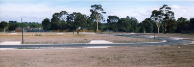
Photograph, Sub-division of the former Mitcham Technical School, C.1996
... Sub-division of the former Mitcham Technical School, C.1996 - looking north....Whitehorse Historical Society Inc. 2-10 Deep Creek Road Mitcham melbourne mitcham technical school knightsbridge subdivision nunawading cherrybrook close Sub-division of the former Mitcham Technical School, C.1996 - looking north. Sub-division of the former Mitcham Technical School, C.1996. ...Sub-division of the former Mitcham Technical School, C.1996 - looking north.mitcham technical school, knightsbridge subdivision, nunawading, cherrybrook close -
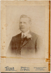 City of Moorabbin Historical Society (Operating the Box Cottage Museum)
Photograph, Black & White, Harry Hale 1861-1937 and House, Cheltenham c1900, c1900
... a) Black & White photograph of the Harry Hale's House c 1930 North Cheltenham b) Sepia photograph c1906 of Harry Hale 1861 - 1937, Builder, Insurance Agent Cheltenham ....; bent thomas, o'shannassy john, king richard, charman stephen, highett william, ormond francis, maynard dennis, market gardeners, vineyards, orchards a) Handwritten information b) Mount ; TALMA, PARIS PANEL , 119 Swanston Street Melbourne and at Sydney a) Black & White photograph of the Harry Hale's House c 1930 North Cheltenham b) Sepia photograph c1906 of Harry Hale 1861 - 1937, Builder, Insurance Agent Cheltenham Photograph, Black & White, Harry Hale 1861-1937 and House, Cheltenham c1900 TALMA , ...Harry Hale 1861-1937, a silk spinner, builder, migrated from England c1890 and built his house using 2nd hand material from the old Mentone Baths, old Co-op Stores, and some windows from the old St Matthew's Church Cheltenham .Harry with wife Frances raised 9 children. Following an accident Harry lost his leg and dissatisfied with the artificial limb he found a 'peg- leg ' more comfortable. Harry built many houses in Cheltenham unhindered by his 'peg-leg' . Harry also worked as an Insurance Agent. \ The house was demolished 1962. ( T. Sheehy, Moorabbin News 1962 H. Stanley )Harry Hale was a typical resourceful early settler who courageously worked with disability as he established his family in Cheltenham c1900a) Black & White photograph of the Harry Hale's House c 1930 North Cheltenham b) Sepia photograph c1906 of Harry Hale 1861 - 1937, Builder, Insurance Agent Cheltenham a) Handwritten information b) Mount ; TALMA, PARIS PANEL , 119 Swanston Street Melbourne and at Sydney hale harry, st matthews church of england cheltenham, talma photographers melbourne, photography, horse drawn carts, toll gates brighton, motor cars 1900, steam engines, early settlers, bentleigh, mckinnon, parish of moorabbin, city of moorabbin, county of bourke, moorabbin roads board, shire of moorabbin, henry dendy's special survey 1841, were j.b.; bent thomas, o'shannassy john, king richard, charman stephen, highett william, ormond francis, maynard dennis, market gardeners, vineyards, orchards -
Clunes Museum
Map, Surface Geology Plan
... .1 C-21 North Broken Hill Ltd Clunes Block 23/19 .2SOUTH CLUNES MINE Ltd Clunes Block 19/19...Clunes Museum 36 Fraser Street enter building through Collins Place Clunes goldfields Plans show various shaft locations north broken hill ltd surface geology plan .1 C-21 North Broken Hill Ltd Clunes Block 23/19 .2SOUTH CLUNES MINE Ltd Clunes Block 19/19 .1 Photocopy of Plan Block 23/19 Scale 1 inch = 100 feet .2 Photocopy of Plan Block 19/19 Scale 1 inch = 100 feet .3 AERIAL PHOTOGRAPH WITH WORKINGS MARKED - LAMINATED Surface Geology Plan Map MAP ...Plans show various shaft locations.1 Photocopy of Plan Block 23/19 Scale 1 inch = 100 feet .2 Photocopy of Plan Block 19/19 Scale 1 inch = 100 feet .3 AERIAL PHOTOGRAPH WITH WORKINGS MARKED - LAMINATED.1 C-21 North Broken Hill Ltd Clunes Block 23/19 .2SOUTH CLUNES MINE Ltd Clunes Block 19/19north broken hill ltd, surface geology plan -
 Buninyong & District Historical Society
Photograph - Colour photograph, View of the bridge on the highway next to Buninyong Golf Club
... View of the bridge on the highway designed by C. P. Wilson looking North....Wilson Engineering Buninyong Shire View of the bridge on the highway designed by C. P. Wilson looking North. View of the bridge on the highway next to Buninyong Golf Club Photograph Colour photograph ...The bridge was designed by C. C. P. Wilson who was the Buninyong Shire engineer from 1908 - 1938 and served as Shire Secretary from 1925 -37.This photograph shows an example of the engineering work of an important member of the Buninyong Shire and community in the early part of the 20th centuryView of the bridge on the highway designed by C. P. Wilson looking North.buninyong, c. c. p. wilson, engineering, buninyong shire -
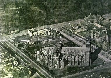 St Patrick's Old Collegians Association (SPOCA)
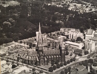
Photograph - Buildings, Aerial, c.1920
... SPJC & Environs from air from North West (c.1920)...St Patrick's Old Collegians Association (SPOCA) Formerly Cnr of Cathedral Place & Lansdowne Street East Melbourne melbourne SPJC & Environs from air from North West (c.1920) Photograph Buildings, Aerial, c.1920 ... -
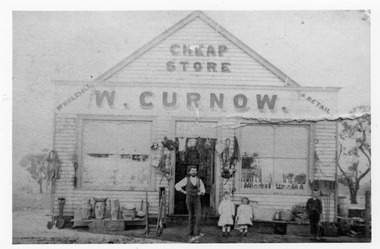 Charlton Golden Grains Museum Inc
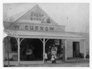
Photograph - Black and white photo of W. Curnow's "Cheap Store" & Retail c. 1900
... Curnow's General store "Cheap Store". c. 1900. Moved from North side of East end of High St to the West end corner of High St....Curnow's "Cheap Store" c. 1900. situated the north side of the East end of High St. ...Curnow's "Cheap Store" c. 1900. situated the north side of the East end of High St. ...W. Curnow's General store "Cheap Store". c. 1900. Moved from North side of East end of High St to the West end corner of High St.Black and white photo of W. Curnow's "Cheap Store" c. 1900. situated the north side of the East end of High St. Charlton. It was later moved to the West end corner of High St Charlton. Items for sale on display outside shop as well as a man and three children.w. curnow, curnow's cheap store, charlton, high st. -
 St Patrick's Old Collegians Association (SPOCA)
Photograph - Buildings, Aerial, c.1970
... SPJC and Environs from air from North West (c.1970, Peter Kelley)...St Patrick's Old Collegians Association (SPOCA) Formerly Cnr of Cathedral Place & Lansdowne Street East Melbourne melbourne SPJC and Environs from air from North West (c.1970, Peter Kelley) Photograph Buildings, Aerial, c.1970 ... -
 Charlton Golden Grains Museum Inc
Photograph - Black and white photo of W. Curnow's "Cheap Store" & Retail c. 1900
... Curnow's General store "Cheap Store" retail & Insurance Agency c. 1900. Moved from North side of East end of High St to the West end corner of High St....Curnow's "Cheap Store" & Retail & Insurance Agency c. 1900. situated the north side of the East end of High St. ...Curnow's "Cheap Store" & Retail & Insurance Agency c. 1900. situated the north side of the East end of High St. ...W. Curnow's General store "Cheap Store" retail & Insurance Agency c. 1900. Moved from North side of East end of High St to the West end corner of High St.Black and white photo of W. Curnow's "Cheap Store" & Retail & Insurance Agency c. 1900. situated the north side of the East end of High St. Charlton. It was later moved to the West end corner of High St Charlton. Items for sale on display outside shop as well as a man and two children. This picture shows a verandah added since picture P1643AW. Curnow's Cheap Store & Insurance Agencyw. curnow, curnow's cheap store, charlton, high st., insurance agency -
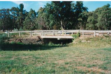
 Eltham District Historical Society Inc
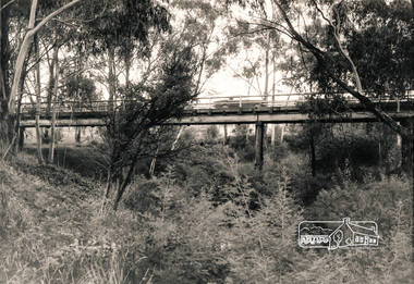
Photograph, Russell Yeoman, Wattletree Road Bridge over the Diamond Creek, Eltham, c.1970
... Black and white photograph from down in gully looking up at Wattletree Road Bridge over Diamond Creek, Eltham North c.1970...At the time the bridge/creek was the boundary between Shire of Eltham and Shire of Diamond Valley bridges diamond creek wattletree road eltham north Black and white photograph from down in gully looking up at Wattletree Road Bridge over Diamond Creek, Eltham North c.1970 Wattletree Road Bridge over the Diamond Creek, Eltham Photograph Russell Yeoman ...At the time the bridge/creek was the boundary between Shire of Eltham and Shire of Diamond ValleyBlack and white photograph from down in gully looking up at Wattletree Road Bridge over Diamond Creek, Eltham North c.1970bridges, diamond creek, wattletree road, eltham north