Showing 1268 items matching "camberwell estate"
-
 Kew Historical Society Inc
Plan - Camberwell Panorama Estate, 1923
... Camberwell Panorama Estate......Camberwell Panorama Estate...Promotional brochure for the Camberwell Panorama Estate. The four page bifold handout advertises 216 home sites bounded by Bulleen Road, The Nook, Fortuna Avenue, and Doncaster Road. ... Panorama Estate Promotional brochure for the Camberwell Panorama Estate. ...Subdivision plans and real estate flyers/brochures reveal a number of aspects of urban development and history. The Kew Historical Society's collection of these plans, as well as advertisements extracted from magazines, cover key aspects of community development and architectural history of Kew and Kew Eat as well as surrounding suburbs. While most of the plans in the collection were gifted to the Society by the former City of Kew, a number of other plans and advertisements have been donated by individuals, of which this is an example.Promotional brochure for the Camberwell Panorama Estate. The four page bifold handout advertises 216 home sites bounded by Bulleen Road, The Nook, Fortuna Avenue, and Doncaster Road. Other streets in the subdivision include: Sunburst Avenue, The Moor, and Macedon Avenue. The brochure has been damaged at some time in the past and so masking tape obscures the tram on page 1. Page 2 includes the plan of the subdivision, page 3 information about the site and a locality plan, while page 4 includes photographs and terms of sale. subdivision plans -- balwyn north (vic.), camberwell panorama estate -
 Melbourne Tram Museum
Ephemera - Real estate sale, Cranny Sambell & Co, "Camberwell Panorama Estate", Oct. 1923
... "Camberwell Panorama Estate"...Estate...Camberwell Panorama Estate...Pamphlet advertising the sale of land at the "Camberwell Panorama Estate" - Doncaster and Bulleen Road 13-10-1923. ...Sale of land trams Real Estate Camberwell Panorama Estate East Camberwell Doncaster Road Bulleen Road tram 20 has pencil notes on the top of the front page. ...Pamphlet advertising the sale of land at the "Camberwell Panorama Estate" - Doncaster and Bulleen Road 13-10-1923. Gives terms of sale, photos showing the views and a nearby shopping centre. Has a large photo of MMTB No. 20 on the front cover. The tramcar is of the Hawthorn Tramways Trust four-door bogie type. MMTB No 20 was an ex-Prahran and Malvern single trucker or small tram A class. Gives details of the 110 lots to be sold, terms, location, and that the tram was proposed to be extended to the corner. This extension took place in 1937. The locality plan shows proposed plans for tram lines in Belmore Road and Burke Road north of Whitehorse Road. Demonstrates the style of land sale pamphlet including the availability of tram services to prospective purchasers.Pamphlet - folded - printed in two colours of cream coloured paper with photographs and plans.has pencil notes on the top of the front page.sale of land, trams, real estate, camberwell panorama estate, east camberwell, doncaster road, bulleen road, tram 20 -
Kew Historical Society Inc
Plan - Tramway Estate, Camberwell North, 1937
... Tramway Estate, Camberwell North...Subdivision plans -- camberwell (Vic.)...tramways estate...Single page subdivision plan listing properties for sale in the Tramways Estate, Camberwell North. The large estate was bounded by Doncaster Road, Burke Road, Marwan Avenue, Maud Street, Severn Street, and extended over Glass's Creek at Mayland's Avenue. ...Plan Tramway Estate, Camberwell North ...Subdivision plans and real estate flyers/brochures reveal a number of aspects of urban development and history. The Kew Historical Society's collection of these plans, as well as advertisements extracted from magazines, cover key aspects of community development and architectural history of Kew and Kew Eat as well as surrounding suburbs. While most of the plans in the collection were gifted to the Society by the former City of Kew, a number of other plans and advertisements have been donated by individuals, of which this is an example.Single page subdivision plan listing properties for sale in the Tramways Estate, Camberwell North. The large estate was bounded by Doncaster Road, Burke Road, Marwan Avenue, Maud Street, Severn Street, and extended over Glass's Creek at Mayland's Avenue. Within the plan, lots 3 to 342 are listed as lots. The plan includes annotations in ink indicating the prices realised by a number of lots. A key explains that lots with an 'H' represent a house, whereas the 37 shaded lots represent those being offered by this agent. subdivision plans -- camberwell (vic.), tramways estate -
 Kew Historical Society Inc
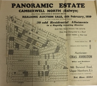
Plan - Subdivision Plan, Panoramic Estate, Camberwell North (Balwyn), 1939, 1939
... Panoramic Estate, Camberwell North (Balwyn), 1939......panoramic estate - camberwell north - balwyn (vic)...Single page subdivision plan of the Panoramic Estate in Camberwell North (Balwyn); offered for sale in 1939...Kew Historical Society Inc Kew Court House 188 High Street Kew melbourne Subdivision plan advertised as the Panoramic Estate, Balwyn, showing lots for sale in the following streets: Bulleen Road, Macedon Avenue, The Moor, Sunburst Avenue, Doncaster Road, Fortuna Avenue, Longview Road, The Nook, and Touring Avenue. subdivision plans - balwyn (vic) panoramic estate - camberwell north - balwyn (vic) Nil Single page subdivision plan of the Panoramic Estate in Camberwell North (Balwyn); offered for sale in 1939 Panoramic Estate, Camberwell North (Balwyn), 1939 Plan Subdivision Plan ...Subdivision plan advertised as the Panoramic Estate, Balwyn, showing lots for sale in the following streets: Bulleen Road, Macedon Avenue, The Moor, Sunburst Avenue, Doncaster Road, Fortuna Avenue, Longview Road, The Nook, and Touring Avenue.Single page subdivision plan of the Panoramic Estate in Camberwell North (Balwyn); offered for sale in 1939Nilsubdivision plans - balwyn (vic), panoramic estate - camberwell north - balwyn (vic) -
 Kew Historical Society Inc
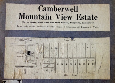
Plan - Subdivision Plan, Camberwell Mountain View Estate, 1923
... Camberwell Mountain View Estate...camberwell...mountain view estate...Camberwell, Deepdene, Balwyn and Hawthorn. It is believed that the majority of the plans were gifted to the Society by persons connected with the real estate firm - J. ...The so-called Camberwell Mountain View Estate was a subdivision on ‘the corner [of] Burke Road, Eyre and Wills Streets, Deepdene’. ...Barnes. subdivision plans - camberwell mountain view estate The so-called Camberwell Mountain View Estate was a subdivision on ‘the corner [of] Burke Road, Eyre and Wills Streets, Deepdene’. ...The Kew Historical Society collection includes almost 100 subdivision plans pertaining to suburbs of the City of Melbourne. Most of these are of Kew, Kew East or Studley Park, although a smaller number are plans of Camberwell, Deepdene, Balwyn and Hawthorn. It is believed that the majority of the plans were gifted to the Society by persons connected with the real estate firm - J. R. Mathers and McMillan, 136 Cotham Road, Kew. The Plans in the collection are rarely in pristine form, being working plans on which the agent would write notes and record lots sold and the prices of these. The subdivision plans are historically significant examples of the growth of urban Melbourne from the beginning of the 20th Century up until the 1980s. A number of the plans are double-sided and often include a photograph on the reverse. A number of the latter are by noted photographers such as J.E. Barnes.The so-called Camberwell Mountain View Estate was a subdivision on ‘the corner [of] Burke Road, Eyre and Wills Streets, Deepdene’. The Estate was not the first attempt to subdivide this land holding. In 1884, 1888 and 1894 the Belmore Park subdivision proposed 18 allotments for this parcel of land. The final stages of the Belmore Park subdivision occurred during the Depression of the 1890s. Apart from perhaps one block facing Burke Road, which is unnumbered in the Mountain View Estate subdivision, the rest must have remained unsold. The later subdivision would redraw the original 18 allotments, creating 22 new lots. In the Locality Plan on the left side of the subdivision plan, Deepdene Station, which formed part of the Outer Circle Railway is represented, as is the location of Deepdene Primary School. A selling point was the proposed extension of the Burke Road tram beyond its terminus at Cotham Road. The extension did not eventuate.subdivision plans - camberwell, mountain view estate -
 Kew Historical Society Inc
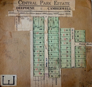
Plan - Subdivision Plan, Central Park Estate, Deepdene - Camberwell, 1923
... Central Park Estate, Deepdene - Camberwell...camberwell...central park estate...Camberwell, Deepdene, Balwyn and Hawthorn. It is believed that the majority of the plans were gifted to the Society by persons connected with the real estate firm - J. ...Barnes. subdivision plans - deepdene - camberwell central park estate An agent’s board on which parts of an advertisement for the Central Park Estate have been pasted. ...The Kew Historical Society collection includes almost 100 subdivision plans pertaining to suburbs of the City of Melbourne. Most of these are of Kew, Kew East or Studley Park, although a smaller number are plans of Camberwell, Deepdene, Balwyn and Hawthorn. It is believed that the majority of the plans were gifted to the Society by persons connected with the real estate firm - J. R. Mathers and McMillan, 136 Cotham Road, Kew. The Plans in the collection are rarely in pristine form, being working plans on which the agent would write notes and record lots sold and the prices of these. The subdivision plans are historically significant examples of the growth of urban Melbourne from the beginning of the 20th Century up until the 1980s. A number of the plans are double-sided and often include a photograph on the reverse. A number of the latter are by noted photographers such as J.E. Barnes.An agent’s board on which parts of an advertisement for the Central Park Estate have been pasted. [The State Library of Victoria holds a complete plan]. Whereas the original plan included black and white photographs and effusive prose about the virtues of the Estate, the item in our collection includes only the actual blocks. The agent has annotated particular blocks to indicate that they have been sold.subdivision plans - deepdene - camberwell, central park estate -
Kew Historical Society Inc
Plan - Pointed Firs Estate, Camberwell North, 1936
... Pointed Firs Estate, Camberwell North...Original multi-page sales brochure of the Pointed Firs Estate, advertised as located in Camberwell North, but now in Balwyn North. ...Plan Pointed Firs Estate, Camberwell North ...Subdivision plans and real estate flyers/brochures reveal a number of aspects of urban development and history. The Kew Historical Society's collection of these plans, as well as advertisements extracted from magazines, cover key aspects of community development and architectural history of Kew and Kew Eat as well as surrounding suburbs. While most of the plans in the collection were gifted to the Society by the former City of Kew, a number of other plans and advertisements have been donated by individuals, of which this is an example.Original multi-page sales brochure of the Pointed Firs Estate, advertised as located in Camberwell North, but now in Balwyn North. The 4-page bifold brochure includes promotional material as well as a detailed plan of the 28 lots for sale, a photograph of the locality with the plan overlaying it, as well as aerial photos and street views. The estate included lots in Doncaster Road, Thackeray Street, Houghton Street, an dMaud Street. pointed firs estate -- balwyn north, subdivisions -- balwyn north (vic.) -
 Kew Historical Society Inc
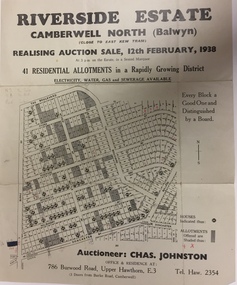
Plan - Subdivision Plan, Riverside Estate, Camberwell North (Balwyn), 1938, 1939
... Riverside Estate, Camberwell North (Balwyn), 1938...Subdivision Plan for 41 lots within the wider Riverside Estate in Camberwell North, now Balwyn, in February 1938. ...Subdivision Plan for 41 lots within the wider Riverside Estate in Camberwell North, now Balwyn, in February 1938. ...This subdivision known as the Riverside Estate wa sone of the largest and most significant in Balwyn's history.Subdivision Plan for 41 lots within the wider Riverside Estate in Camberwell North, now Balwyn, in February 1938. The auction featured lots in Burke Road, The Boulevard, Mt View Road, Wattle Avenue, Kyora Parade, Cascade Street, Riverside Avenue, Walbundry Avenue, Inverness Way, Bulleen Road and Doncaster Road.Allotments for sale are shaded grey on the map. Certain lots have an H in a circle. These are presumably where houses had already been constructed.subdivision plans - balwyn (vic), riverside estate - balwyn (vic) -
 Whitehorse Historical Society Inc.
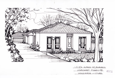
Artwork, other - Ink Line Drawing, 1,2,3/16 Alfred St., Burwood, 1995
... A property illustration by Margaret Picken Commissioned by the real estate agency Woodards, Camberwell for the purpose of advertising 1,2,3/16 Alfred St., Burwood for sale in 1995. ...Woodards Real Estate Camberwell...Depicted are three one-story rendered houses on one block, one behind the other, situated back from a front lawn with a large tree on the right, and a driveway on the left leading to a garage There to two hole punches just below the upper edge An approximately 1.5cmx0.5 tape reside mark at the centre of the bottom edge A 1cm vertical line of dirty tape residue on the center of the upper edge. 1,2,3/16 Alfred St., Burwood Artwork, other Ink Line Drawing Woodards Real Estate Camberwell Margaret Picken ...A property illustration by Margaret Picken Commissioned by the real estate agency Woodards, Camberwell for the purpose of advertising 1,2,3/16 Alfred St., Burwood for sale in 1995. Made by using Rotring ‘Rapidigraph’ drafting pens with Rotring ink on Rapidigraph polyester drafting film, double matte. The suburb lines are believed to have been redrawn, making this property no longer in Burwood, but located in Glen iris. 1/16 Alfred St., Burwood is listed as having sold for in 1995 for $185,000 Trained as a cartographic draftsman within the mining industry, Margaret Picken is an artist who worked producing property illustrations for real estate agencies in eastern suburbs of Victoria from 1983-2005. Retiring from the industry as technological changes favoured coloured photography over illustrations, and commissioning companies over sole contractors.This artwork is of Historical Significance as a record of local domestic architecture.A black ink line drawing on drafters film by Maragret Picken, of 1,2,3/16 Alfred St., Burwood. Depicted are three one-story rendered houses on one block, one behind the other, situated back from a front lawn with a large tree on the right, and a driveway on the left leading to a garage There to two hole punches just below the upper edge An approximately 1.5cmx0.5 tape reside mark at the centre of the bottom edge A 1cm vertical line of dirty tape residue on the center of the upper edge. 1,2,3/16 Alfred St., Burwood Margaret Picken - 95 Woodards - c'wellwhitehorse historical society, schwerkolt cottage, housing, architecture, margaret picken, burwood, glen iris, house, garden -
 Whitehorse Historical Society Inc.
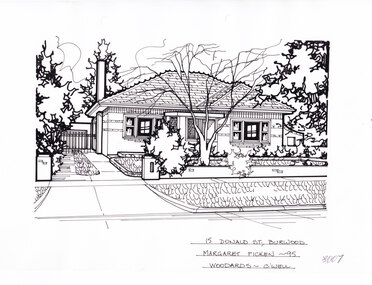
Artwork, other - Ink Line Drawing, Margaret Picken, 15 Donald St., Burwood, 1995
... A property illustration by Margaret Picken Commissioned by the real estate agency Woodards Camberwell for the purpose of advertising 15 Donald St., Burwood in 1995. ...Woodards Real Estate Camberwell...There are two hole punches near the upper edge. 15 Donald St., Burwood Artwork, other Ink Line Drawing Margaret Picken Woodards Real Estate Camberwell ...A property illustration by Margaret Picken Commissioned by the real estate agency Woodards Camberwell for the purpose of advertising 15 Donald St., Burwood in 1995. Made by using Rotring ‘Rapidigraph’ drafting pens with Rotring ink on Rapidigraph polyester drafting film, double matte. This property is listed as having sold for $190,00 in 1995 Trained as a cartographic draftsman within the mining industry, Margaret Picken is an artist who worked producing property illustrations for real estate agencies in eastern suburbs of Victoria from 1983-2005. Retiring from the industry as technological changes favored coloured photography over illustrations, and commissioning companies over sole contractors.This artwork is of Historical Significance as a record of local domestic architecture.A black ink line drawing on drafters film by Margaret Picken, of 15 Donald St., Burwood. A two story weatherboard house set back from a picket fence and and open gate on the right for the driveway. There are two hole punches near the upper edge.15 Donald St., Burwood Margaret Picken - 95 Woodards - c'well whitehorse historical society, schwerkolt cottage, housing, architecture, margaret picken, burwood, house, garden -
 Whitehorse Historical Society Inc.
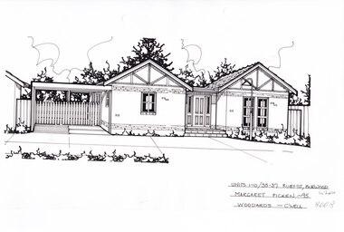
Artwork, other - Ink Line Drawing, Margaret Picken, Units 1-10/35-37 Ruby St., Burwood, 1995
... Woodards Real Estate Camberwell...Units 1-10/35-37 Ruby St., Burwood Artwork, other Ink Line Drawing Margaret Picken Woodards Real Estate Camberwell ...A property illustration by Margaret Picken Commissioned by the real estate agency Woodards for the purpose of advertising Units 1-10/35-37 Ruby St., Burwood in 1995. Made by using Rotring ‘Rapidigraph’ drafting pens with Rotring ink on Rapidigraph polyester drafting film, double matte. This property is listed as having had unit 10 sell for $149,000 in 1995 Trained as a cartographic draftsman within the mining industry, Margaret Picken is an artist who worked producing property illustrations for real estate agencies in eastern suburbs of Victoria from 1983-2005. Retiring from the industry as technological changes favored coloured photography over illustrations, and commissioning companies over sole contractors.This artwork is of Historical Significance as a record of local domestic architecture.A black ink line drawing on drafters film by Margaret Picken, of Units 1-10/35-37 St., Burwood. a single story brick house with two pitched roofs either side of a central porch and front door. There is a connected carport on the left. There are two hole punches near the upper edge.Units 1-10/35-37 Ruby St., Burwood Margaret Picken - 95 Woodards - c'well whitehorse historical society, schwerkolt cottage, housing, architecture, margaret picken, burwood, house, garden -
 Surrey Hills Historical Society Collection
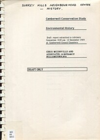
Report, Camberwell conservation study: environmental history 1989 : Draft only, 10/12/1989
... ...camberwell estate...Beginning late 1880s. camberwell land places and structures buildings - conservation and restoration buildings structures and establishments social history public housing camberwell estate st john's wood (wanganella) An environmental history draft report prepared for City of Camberwell as part of the City of Camberwell Conservation Study. ...Full title on cover: Camberwell Conservation Study: environmental history. Draft report submitted to Advisory Committee, 12 December 1989 at Camberwell Council Chambers An environmental history draft report prepared for City of Camberwell as part of the City of Camberwell Conservation Study. Presented in 2 volumes. Charts the development of the suburb of Camberwell. Beginning late 1880s.An environmental history draft report prepared for City of Camberwell as part of the City of Camberwell Conservation Study. Presented in 2 volumes. Charts the development of the suburb of Camberwell. Beginning late 1880s.camberwell, land places and structures, buildings - conservation and restoration, buildings, structures and establishments, social history, public housing, camberwell estate, st john's wood (wanganella) -
 Kew Historical Society Inc
Plan - Subdivision Plan, Golf View Estate, c.1922
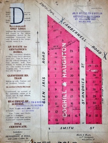
... camberwell...golf view estate...The subdivision advertised as the Golf View Estate in Camberwell included 32 allotments bordering on Glen Iris Road, Smith Street (now Smith Road), St Andries Street and Camberwell Road. ... golf view estate The subdivision advertised as the Golf View Estate in Camberwell included 32 allotments bordering on Glen Iris Road, Smith Street (now Smith Road), St Andries Street and Camberwell Road. ...Pru Sanderson, in her groundbreaking ‘City of Kew Urban Conservation Study : Volume 2 - Development History’ (1988), summarised the periods of urban development and subdivisions of land in Kew. The periods that she identified included 1845-1880, 1880-1893, 1893-1921, 1921-1933, 1933-1943, and Post-War Development. These periods were selected as they represented periods of rapid growth or decline in urban development. An obvious starting point for Sanderson’s groupings involved population growth and the associated economic cycles. These cycles also highlighted urban expansion onto land that was predominantly rural, although in other cases it represented the decline and breakup of large estates. A number of the plans in the Kew Historical Society’s collection can also be found in other collections, such as those of the State Library of Victoria and the Boroondara Library Service. A number are however unique to the collection.The Kew Historical Society collection includes almost 100 subdivision plans pertaining to suburbs of the City of Melbourne. Most of these are of Kew, Kew East or Studley Park, although a smaller number are plans of Camberwell, Deepdene, Balwyn and Hawthorn. It is believed that the majority of the plans were gifted to the Society by persons connected with the real estate firm - J. R. Mathers and McMillan, 136 Cotham Road, Kew. The Plans in the collection are rarely in pristine form, being working plans on which the agent would write notes and record lots sold and the prices of these. The subdivision plans are historically significant examples of the growth of urban Melbourne from the beginning of the 20th Century up until the 1980s. A number of the plans are double-sided and often include a photograph on the reverse. A number of the latter are by noted photographers such as J.E. Barnes.The subdivision advertised as the Golf View Estate in Camberwell included 32 allotments bordering on Glen Iris Road, Smith Street (now Smith Road), St Andries Street and Camberwell Road. In the post-war period in which the subdivision took place, the significance of Camberwell as the ‘Heathiest of Suburbs’ because of the undulating nature of its terrain and its high altitude was promoted. The sales pitch aimed at attracting and selling to ‘Gentlemen’ who could take advantage of the nearby trams, which would take them to the ‘heart of the city’.subdivision plans - camberwell, golf view estate -
Canterbury History Group
Ephemera - Hassets Estate, 26/03/1927
... Camberwell...Real Estate Pamphlet...64 Homes and 27 shop positions for sale in 1927 Canterbury East Camberwell Real Estate Pamphlet Coghill & Haughton 8 Page Coloured Pamphlet 8 Photographs, Map Ephemera Hassets Estate Coghill & Haughton ...64 Homes and 27 shop positions for sale in 19278 Page Coloured Pamphlet 8 Photographs, Mapcanterbury, east camberwell, real estate pamphlet, coghill & haughton -
 Kew Historical Society Inc
Plan - Subdivision Plan, Myrtle Park Estate, City of Camberwell, 1916
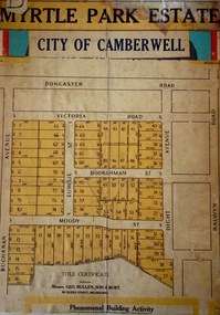
... Myrtle Park Estate, City of Camberwell...myrtle park estate - camberwell [surrey hills]...Camberwell, Deepdene, Balwyn and Hawthorn. It is believed that the majority of the plans were gifted to the Society by persons connected with the real estate firm - J. ...The Estate took its name from Myrtle Park (later changed to Macleay Park), which had been created in 1923 by Camberwell Council. ...Barnes. subdivision plans - balwyn myrtle park estate - camberwell [surrey hills] The ‘Myrtle Park Estate’ was a subdivision bounded by Victoria Road (now Lansdowne Street), Buchanan Avenue and Dight Avenue. ...The Kew Historical Society collection includes almost 100 subdivision plans pertaining to suburbs of the City of Melbourne. Most of these are of Kew, Kew East or Studley Park, although a smaller number are plans of Camberwell, Deepdene, Balwyn and Hawthorn. It is believed that the majority of the plans were gifted to the Society by persons connected with the real estate firm - J. R. Mathers and McMillan, 136 Cotham Road, Kew. The Plans in the collection are rarely in pristine form, being working plans on which the agent would write notes and record lots sold and the prices of these. The subdivision plans are historically significant examples of the growth of urban Melbourne from the beginning of the 20th Century up until the 1980s. A number of the plans are double-sided and often include a photograph on the reverse. A number of the latter are by noted photographers such as J.E. Barnes.The ‘Myrtle Park Estate’ was a subdivision bounded by Victoria Road (now Lansdowne Street), Buchanan Avenue and Dight Avenue. Other streets that were created by the subdivision included Eurolie Street, Boorahman Street and Moody Street (now Sylvan Street). The Estate took its name from Myrtle Park (later changed to Macleay Park), which had been created in 1923 by Camberwell Council. The Park adjoined the southeast corner of the new subdivision. The Estate included 74 regular allotments characterised by narrow frontages and long blocks. Confusion may have greeted prospective purchasers as the Estate was advertised in the daily newspapers as being in East Kew, rather than in Camberwell, where it was at that stage located.subdivision plans - balwyn, myrtle park estate - camberwell [surrey hills] -
 Whitehorse Historical Society Inc.
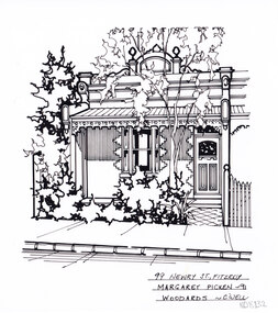
Artwork, other - Ink Line Drawing, Margaret Picken, 99 Newry St., Fitzroy, 1991
... Estate...Camberwell...Whitehorse Historical Society Schwerkolt Cottage Housing Architecture Margaret Picken House Garden Real Estate Camberwell Fitzroy 99 Newry St., Fitzroy Margaret Picken -91 Woodards - Camberwell A black ink line drawing on drafters film by Margaret Picken, of a single story brick row house with bullnose veranda. ...A property illustration by Margaret Picken Commissioned by a real estate agency for the purpose of advertising 99 Newry St., Fitzroy. This property is listed as having sold for $148,000 in 1991 Made by using Rotring ‘Rapidigraph’ drafting pens with Rotring ink on Rapidigraph polyester drafting film, double matte. Trained as a cartographic draftsman within the mining industry, Margaret Picken is an artist who worked producing property illustrations for real estate agencies in eastern suburbs of Victoria from 1983-2005. Retiring from the industry as technological changes favored coloured photography over illustrations, and commissioning companies over sole contractors.This artwork is of Historical Significance as a record of local domestic architecture.A black ink line drawing on drafters film by Margaret Picken, of a single story brick row house with bullnose veranda. In the left foreground is a small front garden with gumtree, and on the right is a tile path to the front door. 99 Newry St., Fitzroy Margaret Picken -91 Woodards - Camberwellwhitehorse historical society, schwerkolt cottage, housing, architecture, margaret picken, house, garden, real estate, camberwell, fitzroy -
Canterbury History Group
Map - Map of Canterbury, Surrey Hills, Mont Albert and Camberwell, c1930s
... Camberwell... Maps... Real Estate...Canterbury History Group 190A Canterbury Road Canterbury melbourne Canterbury Canterbury Road Surrey Hills Mont Albert Camberwell Maps Real Estate Agents Map produced and distributed by White & Clarke Real Estate Agents in Canterbury c 1930 Map Map of Canterbury, Surrey Hills, Mont Albert and Camberwell ...Map produced and distributed by White & Clarke Real Estate Agents in Canterbury c 1930canterbury, canterbury road, surrey hills, mont albert, camberwell, maps, real estate agents -
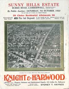 Melbourne Tram Museum
Ephemera - Real estate sale, Knight Harwood, "Sunny Hills Estate" - Burke Road Camberwell, Oct. 1922
... "Sunny Hills Estate" - Burke Road Camberwell...Estate...Burke Road...Camberwell...Pamphlet advertising the sale of land at the "Sunny Hills Estate" Burke Road Camberwell 7-10-1922. Gives terms of sale, photos showing a nearby shopping centre, recently constructed houses, and plan of the subdivision. ... Burke Road Camberwell Sunny Hills Estate has ink notes re sale price and notes. ...Pamphlet advertising the sale of land at the "Sunny Hills Estate" Burke Road Camberwell 7-10-1922. Gives terms of sale, photos showing a nearby shopping centre, recently constructed houses, and plan of the subdivision. Land prices have been written in for each block on the pamphlet. Has a photo featuring Camberwell Junction with a tram, and Burke Road view with trams. Demonstrates the style of land sale pamphlet including the availability of tram services to prospective purchasers.Pamphlet - folded - printed in three colours of cream coloured paper with photographs and plans.has ink notes re sale price and notes.sale of land, trams, real estate, burke road, camberwell, sunny hills estate -
 Kew Historical Society Inc
Plan - Subdivision Plan, Jas R Mathers Son & McMillan, Camberwell City Heights, 1922
... Housing estates such as the 1919 Balwyn Park Estate, 1922 Hillcrest Estate and the Camberwell City Heights Estate, also 1922, quickly followed. ...Housing estates such as the 1919 Balwyn Park Estate, 1922 Hillcrest Estate and the Camberwell City Heights Estate, also 1922, quickly followed. ..."Following the 1919 amalgamation of suburban tramway trusts, an electrified tram service extended along Doncaster Road. Housing estates such as the 1919 Balwyn Park Estate, 1922 Hillcrest Estate and the Camberwell City Heights Estate, also 1922, quickly followed. These estates were built over by expansive suburban villas, set in fine gardens and along tree-lined streets. North Balwyn, largely constructed since 1933, was typified by even grander houses, many of them in the 'ocean liner' style and seen at their most distinctive in the Riverview Estate." (Source; 'Balwyn' in eMelbourne)Portions of subdivision plan mounted on both sides of cardboard sheet. Coloured pink, probably to show allotments sold. Area covered: Doncaster Road, Mountainview Road, Panoramic Road, Cityview Road, Longview Road, Riverview Road, Hillview Road, Bulleen Road. Includes location diagram showing railway lines and existing and proposed tram routes.Cardboard backing has advertisement for "Tillock's soluble coffee"subdivision plans -- camberwell (vic.), camberwell city heights subdivision -
 Flagstaff Hill Maritime Museum and Village
Container - Horse trough, Annis & George Bills, circa Dec. 1932
... In 1927 George moved from Hawthorn to Camberwell, where he passed away at the end of that year. George had requested in his Will that a trust fund be set up from his estate "…construct and erect and pay for horse troughs wherever they may be of the opinion that such horse troughs are desirable for the relief of horses and other dumb animals either in Australasia, in the British Islands or in any other part of the world subject to the consent of the proper authorities being obtained." ...In 1927 George moved from Hawthorn to Camberwell, where he passed away at the end of that year. George had requested in his Will that a trust fund be set up from his estate "…construct and erect and pay for horse troughs wherever they may be of the opinion that such horse troughs are desirable for the relief of horses and other dumb animals either in Australasia, in the British Islands or in any other part of the world subject to the consent of the proper authorities being obtained." ...This horse trough is the only survivor of the two troughs originally installed in Raglan Parade, Warrnambool, in 1932. It was later moved to the Pony Club at Albert Part, near the north corner of Coulstock and Craig Streets. Over the time there its purpose was changed from a horse watering trough to a colourful garden bed of agapanthus plants. By February 2013 the horse trough had been transferred to Flagstaff Hill for display in the Maritime Village’s grounds. This trough is one of hundreds provided by the Annis and George Bills Estate Trust since 1927 for the welfare of working horses and dogs. The original concrete cap over the small compartment is still retained. There are also markings on the right side of the trough where it probably had a birdbath, tap or a dish for the horseman’s dog, similar to other troughs donated elsewhere by the Trust. Less than half of the troughs produced for the Annis and George Bills Trust still survive. In 2017 Felicity Watson, National Trust Victoria’s advocacy manager, said that the troughs were treasures and becoming rare, with more than a dozen across Victoria now being heritage protected. ABOUT ANNIS AND GEORGE BILLS The 1927 Will of George Bills included setting up the Annis and George Bills Estate Trust, which provided for hundreds of horse troughs to be supplied and installed throughout Australia, Britain, USA and other parts of the world for the welfare of horses. Town and city councils could apply to the Trustees for a horse trough for their communities. George “Joe” Bills was born in Brighton, England, in 1859. The family migrated first to New Zealand then to Australia in 1873, settling in the Echuca-Moama district. George moved to Brisbane in 1882 where he met Annis Swann, formerly from Sheffield. Both were animal lovers. George and Annis married 1885 and moved to Sydney to join George’s brother Henry in his mattress wire weaving business, later known as the Bills Brothers. They patented their own machine in 1893 and the business became very profitable. George was able to donate to charities that supported his passion to improve animal welfare. He and Annis joined the Victorian Society for the Protection of Animals and in 1924 George received a Life Membership with the RSPCA. George retired in 1908. The couple moved to Hawthorn, Victoria, in 1910, where they donated troughs for the work horses of Melbourne. During a visit to England Annis passed away. In 1927 George moved from Hawthorn to Camberwell, where he passed away at the end of that year. George had requested in his Will that a trust fund be set up from his estate "…construct and erect and pay for horse troughs wherever they may be of the opinion that such horse troughs are desirable for the relief of horses and other dumb animals either in Australasia, in the British Islands or in any other part of the world subject to the consent of the proper authorities being obtained." The troughs were to bear a plaque inscribed “Donated by Annis and George Bills, Australia”. In 1927 the cost to make a trough was about £13 (which converts to about $1079 in 2020 ), plus transport and installation costs. Most of the troughs were installed between 1930 and 1939 in Victoria and New South Wales. It is estimated that over that time around 500-700 Bills Horse Troughs were installed in Australia and another 50 overseas. Most of the troughs made in Victoria had three moulded front panels like this trough, and no panels moulded on the rear, whereas troughs made in NSW had four panels on the front and five on the back. Victorian troughs were made by a Bills’ relative, J H Phillips. Later, other manufactures for the Trust’s troughs included Rocla Concrete Pipes Ltd, in Auburn Road, Hawthorn, Victoria, who produced to the same original design. No further troughs produced after the end of World War II. A memorial to Annis and George Bills was first erected in Hawthorn in 1929. It included a drinking fountain and a dog dish. Its current location is unknown. In 1964 the George Bills RSPCA Resource Centre opened in Burwood East. This Bills horse trough is nationally significant as one of the surviving examples of the standard Bills memorial horse troughs that still has its compartment cap and evidence of it once having had attached fittings, possibly for a birdbath or dog dish. This trough has State historical significance for being produced in the early 1930s by a business in Hawthorn, Victoria. This example of a Bills horse trough is significant for being in comparatively good condition. The trough is locally significant for being the sole survivor of the two Bills horse troughs installed in the City of Warrnambool in 1932, originally installed on Raglan Parade and continued to be used in the community at the Pony Club, then finally transferred to its current location at Flagstaff Hill by early 2013. It is culturally significant as it represents the community’s dependence on horses for travel and transportation previous to motorised vehicles. It is morally significant as a generous gift from a couple concerned with the welfare of animals.Horse trough; a long narrow rectangular container used for storing water. Trough is made from pre-cast concrete with one large open compartment and a small covered compartment. The base of the small compartment is raised slightly above the base of the trough and is covered by a removable concrete cap. The design of the front of the trough includes three panels moulded into it that align with the shape of the back pediment (panel). The pediment is shaped with side arcs that step up to a wide centre arc. A rectangular concrete plaque is cast into the centre of the pediment and is engraved with the names of the original donors, Annis and George Bills. The trough was made in Hawthorn, Victoria, by J H Phillips circa 1932. “DONATED BY / ANNIS & GEORGE BILLS / AUSTRALIA”flagstaff hill, warrnambool, shipwrecked coast, flagstaff hill maritime museum, maritime museum, shipwreck coast, flagstaff hill maritime village, great ocean road, annis and george bills, bills trust, j h phillips, rocla concrete pipes ltd, hawthorn, water trough, watering trough, horse trough, animal welfare, bills horse trough -
 Surrey Hills Historical Society Collection
Photograph, Mary Sneddon with daughter Jean
... estate agency in Surrey Hills from the 1880s. Born in1875, Sandhurst (Bendigo); died in 1957, Deepdene. Buried Box Hill Cemetery: P-061-0033. They had the following children: Jim (James 3rd) b 1905, Balwyn Jack (John William) b. 1908, Camberwell Norman Alexander b 1910, Camberwell Alan Coulson b 1914 Surrey Hills Jean Isabel b 1916, Surrey Hills Douglas Haig b 1918, Surrey Hills. ...estate agency in Surrey Hills from the 1880s. Born in1875, Sandhurst (Bendigo); died in 1957, Deepdene. Buried Box Hill Cemetery: P-061-0033. They had the following children: Jim (James 3rd) b 1905, Balwyn Jack (John William) b. 1908, Camberwell Norman Alexander b 1910, Camberwell Alan Coulson b 1914 Surrey Hills Jean Isabel b 1916, Surrey Hills Douglas Haig b 1918, Surrey Hills. ...The photo was taken in the garden of of 'Cliburn', 14 Suffolk Avenue, Surrey Hills, the home of William and Mary (nee Bird) Sneddon. It was named after Cliburn, Westmorland (later Cumbria) where Mary's mother was born and the name was given to all their homes. Mary Bird, daughter of John Bird and Mary Coulston, b 1878 Bethanga, Victoria; died 1948, Surrey Hills. They were married on 12/11/1903 in Surrey Hills at the home of James Sneddon. William Sneddon was a postman in Surrey Hills for many years. His father James had an estate agency in Surrey Hills from the 1880s. Born in1875, Sandhurst (Bendigo); died in 1957, Deepdene. Buried Box Hill Cemetery: P-061-0033. They had the following children: Jim (James 3rd) b 1905, Balwyn Jack (John William) b. 1908, Camberwell Norman Alexander b 1910, Camberwell Alan Coulson b 1914 Surrey Hills Jean Isabel b 1916, Surrey Hills Douglas Haig b 1918, Surrey Hills. Additional information from Robin da Costa-Adams, who is related to the Sneddon family through her first marriage. Sepia photo of Mary Sneddon with daughter Jean wearing hats and taken in a garden. Mary is seated and Jean stands beside her. Part of the house next door can be seen in the background. It is an Edwardian timber home"Jean Sneddon / Mary Sneddon/ (in grey lead pencil by Robin da Costa-Adams. 1050 in blue biro crossed out in top RH corner. KODAK PRINT - black stamp in centre. "Jean dau of Mary - / Will. Sneddon" in black ink in Jocelyn Hall's hand. cliburn, suffolk road, (miss) jean sneddon, william sneddon, (mrs) mary sneddon, (miss) mary bird -
 Surrey Hills Historical Society Collection
Photograph, Mary Sneddon
... estate agency in Surrey Hills which had been established by his father, also James, in the 1880s. William married Mary nee Bird in 1903 at his father's home. They lived at 'Cliburn' 14 Suffolk Road, named after Cliburn, Westmorland (later Cumbria) where Mary's mother, Mary Coulston came from. According to the donor, all their homes were given this name. WIlliam and Mary had the following children: Jim (James 3rd) b 1905, Balwyn Jack (John William) b. 1908, Camberwell...estate agency in Surrey Hills which had been established by his father, also James, in the 1880s. William married Mary nee Bird in 1903 at his father's home. They lived at 'Cliburn' 14 Suffolk Road, named after Cliburn, Westmorland (later Cumbria) where Mary's mother, Mary Coulston came from. According to the donor, all their homes were given this name. WIlliam and Mary had the following children: Jim (James 3rd) b 1905, Balwyn Jack (John William) b. 1908, Camberwell ...Mary was married to William Sneddon who was a postman in Surrey Hills for many years. His father James ran an estate agency in Surrey Hills which had been established by his father, also James, in the 1880s. William married Mary nee Bird in 1903 at his father's home. They lived at 'Cliburn' 14 Suffolk Road, named after Cliburn, Westmorland (later Cumbria) where Mary's mother, Mary Coulston came from. According to the donor, all their homes were given this name. WIlliam and Mary had the following children: Jim (James 3rd) b 1905, Balwyn Jack (John William) b. 1908, Camberwell Norman Alexander b 1910, Camberwell Alan Coulson b 1914, Surrey Hills Jean Isabel b 1916, Surrey Hills Douglas Haig b 1918, Surrey Hills. William and Mary are buried in Box Hill Cemetery: P-061-0033. The donor Robin da Costa-Adams is related to the Sneddon family through her first marriage. Formal sepia photo of Mary Sneddon seated in a studio or against a backdrop provided by a travelling photographer. "Mary Sneddon" - Robin da Costa-Adams' hand in grey lead pencil. "nee Bird) / (wife of Wm Sneddon" in black ink in Jocelyn Hall's hand.(miss) mary bird, (mrs) mary sneddon, william sneddon -
 Surrey Hills Historical Society Collection
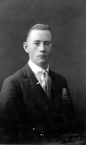
Photograph, Jack Sneddon
... His father James ran an estate agency in Surrey Hills established by his father in the 1880s. William's wife was Mary Sneddon (nee Bird). Jack was born in 1908 in Camberwell. ...His father James ran an estate agency in Surrey Hills established by his father in the 1880s. William's wife was Mary Sneddon (nee Bird). Jack was born in 1908 in Camberwell. ...John William (Jack) was the son of William and Mary Sneddon and brother of Alan. William Sneddon was a postman in Surrey Hills for many years. His father James ran an estate agency in Surrey Hills established by his father in the 1880s. William's wife was Mary Sneddon (nee Bird). Jack was born in 1908 in Camberwell. In 1937 his address was 19 Albert Street, Surrey Hills. The donor Robin da Costa-Adams is related to the Sneddon family through her first marriage.Formal sepia head and shoulders photo of Jack Sneddon dressed in a suit and tie. 'Crown/ Studios/ Melbourne' impressed on original in lower RH corner.jack sneddon, john william sneddon, (miss) mary bird, (mrs) mary sneddon, james sneddon, crown studios -
 Surrey Hills Historical Society Collection
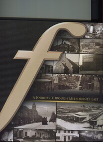
Book, A journey through Melbourne's east, 2008
... estate agents...melbourne...hawthorn...balwyn...camberwell...A collection of photographs of the local eastern area of Melbourne showing a lot of 'then' and 'now' photographs. fletcher and parker fletchers real estate agents melbourne hawthorn balwyn camberwell kew land use ashburton montagnana-wallace (mr) neil wallace (mr) neil montagnana A collection of photographs of the local eastern area of Melbourne showing a lot of 'then' and 'now' photographs. ...Pictorial representation of the development of Melbourne's eastern suburbs. A collection of photographs of the local eastern area of Melbourne showing a lot of 'then' and 'now' photographs.A collection of photographs of the local eastern area of Melbourne showing a lot of 'then' and 'now' photographs.fletcher and parker, fletchers, real estate agents, melbourne, hawthorn, balwyn, camberwell, kew, land use, ashburton, montagnana-wallace, (mr) neil wallace, (mr) neil montagnana -
 Surrey Hills Historical Society Collection
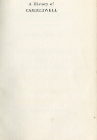
Book, A History of Camberwell, 1964
... Published [Brisbane] : Jacaranda Press in association with the Camberwell City Council, 1964 From estate of Ken Hall; Cheryl Poustie was Ken's daughter. ...Published [Brisbane] : Jacaranda Press in association with the Camberwell City Council, 1964 From estate of Ken Hall; Cheryl Poustie was Ken's daughter. ...Includes description including photographs of Camberwell Junction and Burke Road, pre 1950's era. Electric transport 1916-1925, tools and waterways. Published [Brisbane] : Jacaranda Press in association with the Camberwell City Council, 1964 From estate of Ken Hall; Cheryl Poustie was Ken's daughter. Records in detail history and development of the Melbourne suburb of Camberwell. A city covering thirteen square miles. Begins with first European settlement in 1835 by John Gardiner - ending at 1960.Records in detail history and development of the Melbourne suburb of Camberwell. A city covering thirteen square miles. Begins with first European settlement in 1835 by John Gardiner - ending at 1960.Title Page: Kenneth T.Hall / 89-4418camberwell - history, (mr) john gardiner, outer circle railway, camberwell (vic) - history, broughton hall -
 Surrey Hills Historical Society Collection
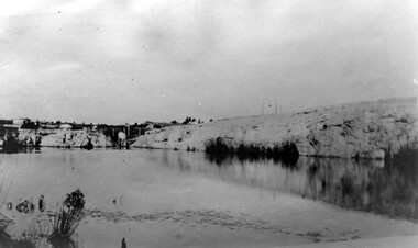
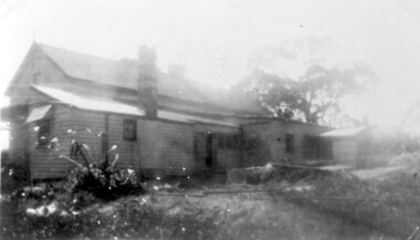
Photograph, Grovedale Road Quarry in the 1920s - looking south, c1920
... The property was subdivided into 110 house blocks in c1923 - see Maling's Estate subdivision flyer on the State Library of Victoria's website. This shows that the Grovedale Park site had been acquired by Camberwell Council by this time. ...The property was subdivided into 110 house blocks in c1923 - see Maling's Estate subdivision flyer on the State Library of Victoria's website. This shows that the Grovedale Park site had been acquired by Camberwell Council by this time. ...The quarry was part of John Butler Maling's property. He was one of the original settlers of the area and farmed the area between Weybridge Street and Whitehorse Road. Clay was quarried from part of this area and used to make the bricks used in the construction of his home, known as 'Ancyra'. This is still extant at the corner of Weybridge and James Streets. Maling grazed cows and used the quarry as a water source. He was the uncle of John Butler Maling, Mayor of Camberwell. He was married to Kate Conlon in 1882. They had 3 children: Silas Young, Alick and Zillah. Maling was born in c1829 in Shepreth, Cambridgeshire; he died in Surrey Hills on 9 October 1912 and is buried in Box Hill Cemetery - CE-*-0586. Mrs Kate Maling (born c1859 in Co Meath, Ireland) died at the property on 8 March 1921. She is buried in Brighton General Cemetery. Probate was valued at over 10,000 pounds and included other properties in Sandringham, Hawthorn and Macedon. At the time of her death the Surrey Hills property was described as being 23 acres with 2 brick houses, 1 cow, 2 heifers and 40 fowls or chickens. The property was subdivided after her death. The property was subdivided into 110 house blocks in c1923 - see Maling's Estate subdivision flyer on the State Library of Victoria's website. This shows that the Grovedale Park site had been acquired by Camberwell Council by this time. An attached newspaper clipping documents prices realised for a cross-section of blocks. The MMBW map of 1925, also on the SLV website, shows the outline of the clayhole / quarry. The quarry was filled in after several drownings or near drownings and the land is now occupied by a park and playground, known as Grovedale Road Park, maintained by the City of Boroondara. Beckett Park is sited on horizon to the left beyond the trees. This documents the landscape prior to close settlement and is material to early building and farming in the Surrey Hills area.Black and white photo of the quarry between Grovedale Road and James Street taken in the 1920s and looking south. In the foreground is an area of water with reeds in the LH corner. Beyond on the high banks there are single storey houses in the background and (?) some light poles. An object that looks like a tank on posts is in a cutting on the far bank.quarries, grovedale road, james street, clay quarries, farming, kate conlon, kate maling, john butler maling, ancyra -
 Surrey Hills Historical Society Collection
Photograph, 6a Thistle Street, Surrey Hills, 1924
... Camberwell. Thomas was active in land sales and variously described as a land agent, real estate agent and auctioneer. ...Camberwell. Thomas was active in land sales and variously described as a land agent, real estate agent and auctioneer. ...One of the oldest homes in Surrey Hills. The photo was taken in 1924 when the property was purchased by Mr John Francis Evans, father of Mrs Lillian Austin. The Evans family came from Gembrook. John Evans was born in Wales; he and his wife Mary had 3 children, 2 daughters and one son. Mary Evans pre-deceased her husband, who died on 23 October 1924 at Hillsborough, 6A Thistle Street. The first owner of the property was Mrs Rachel Sweetnam (nee Lewis) who married Thomas Edward Sweetnam on 24 September 1884 at St John's Church, Camberwell. REF: THE ARGUS 4 Oct 1884 Thomas second eldest surviving son of Matthew Sweetnam married to Rachel (Ray) third eldest daughter of Captain T.D. Lewis, Culm Haven, Camberwell. Thomas was active in land sales and variously described as a land agent, real estate agent and auctioneer. The property - Hillsboro or Hillsborough - was originally a house on a farm of 10 acres owned by her. It became 6A Thistle Street. According to the Alan Holt property register Rachel Sweetnam owned the property prior to 1890 and a family tree on Ancestry.com has that it was owned by her in c1886. It is likely that at this stage the property was an investment rather than the Sweetnam's family residence. Other property owners or residents are: 1890 Selina Gaylor 1900 Stephen Pullen 1910 William Murray (draftsman) 1920 George C Hughes 1930 Arthur Leslie Austin (tram driver) 1980 Mrs Lillian Evelyn Austin Lillian Austin died on 19 August 1983 and the property was sold that year for $87,000. The house is still extant (January 2025). Note that we also have material / photos regarding George Hughes and family.Black and white photo of a timber home with brick chimneys and a (?) corrugated iron roof. There are sheds and outbuildings attached to the house. The garden looks untended. In the background a mature eucalypt tree can be seen.houses, hillsboro, timber houses, mrs lillian austin, hillsborough, selina gaylor, stephen pullen, william murray, george hughes, arthur austin, john francis evans, thistle street -
 Surrey Hills Historical Society Collection
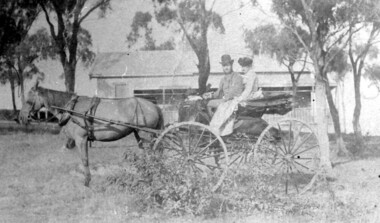
Photograph, 'Hillsboro' or "Hillsborough' - 6a Thistle Street, Surrey Hills, pre-1890
... Camberwell. Thomas was active in land sales and variously described as a land agent, real estate agent and auctioneer. ...Camberwell. Thomas was active in land sales and variously described as a land agent, real estate agent and auctioneer. ...The photo was found behind a mantelpiece in the house at 6A Thistle Street while it was being renovated. It is thought to be of the first owner, Mrs Rachel Sweetnam (nee Lewis) and her husband, Thomas Edward Sweetnam. They were married on 24 September 1884 at St John's Church, Camberwell. REF: THE ARGUS 4 Oct 1884 Thomas second eldest surviving son of Matthew Sweetnam married to Rachel (Ray) third eldest daughter of Captain T.D. Lewis, Culm Haven, Camberwell. Thomas was active in land sales and variously described as a land agent, real estate agent and auctioneer. The property - Hillsboro or Hillsborough - was originally a house on a farm of 10 acres owned by her. It became 6A Thistle Street. According to the Alan Holt property register Rachel Sweetnam owned the property prior to 1890 and a family tree on Ancestry.com has that it was owned by her in c1886. It is likely that it was an investment rather than a family residence. Thomas Sweetnam was President of the Boroondara Shire 1888/89 and a councillor from 1886-1891. During his time as Shire councillor in 1887 he was charged with assaulting Charles A. Chandler, a window blind manufacturer, in response to an ‘insulting note’ left at Sweetnam’s house. Sweetnam was fined two guineas and 31 shillings. Sweetnam was also President of the Camberwell Gun Club from around 1890 – 91. In 1893 he relocated to Ferntree Gully, where he contested for the municipality’s North Riding council seat. Multiple references can be found on Trove. Note that the gentleman in this photo does bear a resemblance to Thomas Sweetman, President of Boroondara Shire in 1888-1889 found in the City of Boroondara Library Service mayoral portrait collection. No known photo of Rachel Sweetnam. Other property owners or residents are: 1890 Selina Gaylor 1900 Stephen Pullen 1910 William Murray (draftsman) 1920 George C Hughes 1930 Arthur Leslie Austin (tram driver) 1980 Mrs Lillian Evelyn Austin Sold in 1983 for $87,000. The house is still extant (January 2025). Note that we also have material / photos regarding George Hughes and family.This photo is one of the earliest photos of residences of Surrey Hills.Black and white photo of a woman and man in a buggy behind which is a simple house with a verandah at one end, surrounded by eucalypt trees.hillsboro, house names, thistle street, horse-drawn vehicle, clothing and dress, hillsborough, rachel sweetnam, rachel lewis, thomas sweetnam, selina gaylor, stephen pullen, william murray, george hughes, arthur austin, lillian austin -
Surrey Hills Historical Society Collection
Folder of information, Libby Cavenagh's 1990 building census of Wandsworth Road, Surrey Hills, 1990
... estate advertisements. There are a number of appendices including s a map of the breakdown of styles and materials; date of construction and other information from the Camberwell Building registers 1890-1934; entries re owners from Sands & McDougall directories, 1897-1937; map from Land Titles Office showing sub-division information; land auction advertisements; information re W J Vine; list of builders; references....estate advertisements. There are a number of appendices including s a map of the breakdown of styles and materials; date of construction and other information from the Camberwell Building registers 1890-1934; entries re owners from Sands & McDougall directories, 1897-1937; map from Land Titles Office showing sub-division information; land auction advertisements; information re W J Vine; list of builders; references. ...Libby Cavenagh was Secretary of the Surrey Hills Historical Society. She completed this study as part of a Diploma of Local History she was undertaking at the University of New England. At the time she lived in Wandsworth Road.This is a unique analysis of the housing stock of a complete street at one point in time. Many of the houses have been altered since the study was completed and quite a number have been demolished.Blue folder of A4 size. This contains an analysis of each house in Wandsworth Road in 1990 with details regarding building style, approximate age, materials used, fence design, presence or absence of a garage or carport and some comment on the garden elements. For most entries there is a coloured photo taken from the street. For some there are photocopies of real estate advertisements. There are a number of appendices including s a map of the breakdown of styles and materials; date of construction and other information from the Camberwell Building registers 1890-1934; entries re owners from Sands & McDougall directories, 1897-1937; map from Land Titles Office showing sub-division information; land auction advertisements; information re W J Vine; list of builders; references.wandsworth road, libby cavenagh -
 Surrey Hills Historical Society Collection
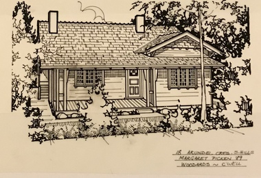
Drawing - Architectural drawing, 18 Arundel Crescent, Surrey Hills by Margaret Picken, 1989, 1989
... estate agents in Melbourne between c.1983 and 2005. Each work is signed and dated. Margaret Picken approached a number of historical societies in July 2020 with a view to donating her work. Sketches for post code 3127 are held by this collection. Others for suburbs including Ashburton, Balwyn, Camberwell...estate agents in Melbourne between c.1983 and 2005. Each work is signed and dated. Margaret Picken approached a number of historical societies in July 2020 with a view to donating her work. Sketches for post code 3127 are held by this collection. Others for suburbs including Ashburton, Balwyn, Camberwell ...Margaret Picken (1950-) trained and worked as a cartographic draftsman from 1968-1975 within the mining industry. These skills were readily transferable to work as a property illustrator for the real estate industry. Process: “Sketches were ordered by phone initially as there were no mobile phones or computers then. I would take our 2 year-old son with me to the houses when the other 2 boys were at school. I photographed houses with a Polaroid camera and made a ‘thumbnail’ sketch while there. The photos were used to scale off a sketch in pencil and then that sketch was overlaid with drafting film and the ‘pen and ink’ was completed. This process was the only one I used the entire time. Polaroid photos gave an instant usable photo. I then delivered the sketches by hand to the offices. There were deadlines each week on a Tuesday.” “… about 2003 coloured photos began to take over the sketches and mainstream companies replaced sole traders like myself providing a one-stop shop for all advertising. I produced my last Real Estate sketches in late 2005.” Margaret Picken (1950-) trained and worked as a cartographic draftsman from 1968-1975 within the mining industry. These skills were readily transferable to work as a property illustrator for the real estate industry. This architectural drawing is one of a series created by Margaret Picken for a range of real estate agents in Melbourne between c.1983 and 2005. Each work is signed and dated. Margaret Picken approached a number of historical societies in July 2020 with a view to donating her work. Sketches for post code 3127 are held by this collection. Others for suburbs including Ashburton, Balwyn, Camberwell, Canterbury, Blackburn, Box Hill, Burwood, Glen Iris, Hawthorn, Kew, Mont Albert North and Nunawading have been donated to the relevant historical group in those suburbs. (See Balwyn Historical Society, Box Hill Historical Society, Camberwell Historical Society, Hawthorn Historical Society, Kew Historical Society, Whitehorse Historical Society). In some cases, this collection also has a copy of the matching newspaper advertisement. Pen and ink architectural drawing on drafting film of 18 Arundel Crescent, Surrey Hills (VIC) by Margaret Picken. The drawing, dated 1989 , was commissioned by the Woodards real estate company.18 ARUNDEL CRES. S. HILLS / MARGARET PICKEN '89 / WOODARDS ~ C'WELLarchitectural drawing, houses, surrey hills / mont albert (vic.), artists, margaret picken 1950-, californian bungalow, arundel crescent