Showing 193 items matching "campaspe"
-
 Returned Nurses RSL Sub-branch
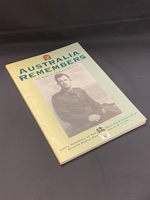
Book - Illustrated paperback book, Shire of Campaspe et al, Australia Remembers 1945-1995: The Shire of Campaspe recalls local memories of the Second World War, 1995
... Australia Remembers 1945-1995: The Shire of Campaspe recalls local memories of the Second World War....The top of the photo is printed 'the Shire of Campaspe recalls'. At the top of the cover is an Australia Remembers emblem and title in large green text. ...Shire of Campaspe...Book Illustrated paperback book Shire of Campaspe Ian H. K. Ilton Campaspe Council ...Part of the Australia Remembers program to commemorate the 50th anniversary of the end of WWII. It is a record of the memories of local Campaspe Shire residents of their experiences during the Second World war.Yellow blending in to a green cover towards the right. Large black and white photographic image of a soldier in uniform in the centre. The top of the photo is printed 'the Shire of Campaspe recalls'. At the top of the cover is an Australia Remembers emblem and title in large green text. Below the photo, at the bottom of the page, is the remaining title and author details, between the two is the emblem fo rthe Shire.non-fictionPart of the Australia Remembers program to commemorate the 50th anniversary of the end of WWII. It is a record of the memories of local Campaspe Shire residents of their experiences during the Second World war.world war 1939-1945, wwii, ww2, campaspe shire, australia remembers -
 Ballarat Heritage Services
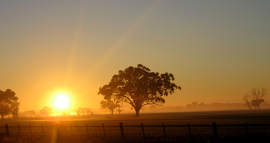
Digital photographs, L.J. Gervasoni, Campaspe Sunrise, c2008
... Campaspe Sunrise...Colour photograph of a sunrise in Campaspe Shire. ...Campaspe Shire, Victoria, Australia...Ballarat Heritage Services PO Box 2209 Bakery Hill Post Office goldfields farm farmland paddock tree paddock sunrise Colour photograph of a sunrise in Campaspe Shire. Campaspe Sunrise Digital photographs L.J. ...Colour photograph of a sunrise in Campaspe Shire. farm, farmland, paddock tree, paddock, sunrise -
 City of Greater Bendigo - Civic Collection
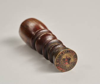
Ceremonial object - Common Seal, Campaspe District Road Board Seal
... Campaspe District Road Board Seal...This wax seal was used by the Campaspe Road Board (later the Huntly Council). ...Campaspe District Road Board...This wax seal was used by the Campaspe Road Board (later the Huntly Council). ...Wax seals have been used since the Middle Ages and are primarily used for legitimising and authenticating official documents. This wax seal was used by the Campaspe Road Board (later the Huntly Council). The first president of the Campaspe Road Board was Sir James Joseph Casey who was a member of the municipal council of Sandhurst prior to holding this position in 1861.Circular, brass seal with wooden handle. Remnants of red wax remain in seal. Campaspe District Road Boardhuntly shire (1866-1994), city of greater bendigo administration item -
 Bendigo Military Museum
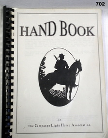
Book, Campaspe Light Horse Association, Handbook of the Campaspe Light Horse Association, 1995
... Handbook of the Campaspe Light Horse Association....Campaspe Light Horse Association...Page 95 Illustrated with some Photos Pen + ink drawings Plus maps front cover has a silhouette of am Aust soldier on horse back, Handbook of the Campaspe Light Horse Association. Book BOOK Campaspe Light Horse Association ...this is virtually a home made bookSoft cover folder Plastic spine A4 size Pace. Page 95 Illustrated with some Photos Pen + ink drawings Plus maps front cover has a silhouette of am Aust soldier on horse back,books, military history -
![Scene on the River Campaspe / [by] Nicholas Caire, circa 1876](/media/collectors/550653872162f11fb04854aa/items/577b50b0d0cdd10948cb4cf6/item-media/577b51d2d0cdd10948cbedda/item-fit-380x285.jpg?cb=6) Kew Historical Society Inc
Kew Historical Society IncPhotograph, Anglo-Australasian Photographic Company, Scene on the River Campaspe, c. 1876
... Scene on the River Campaspe...Views of Victoria (General Series) No.25 / ‘Scene on the River Campaspe’ / Albumen silver photograph mounted on board...On Reverse: ‘The River Campaspe flows into the River Murray, near the Town of Echuca. ...Views of Victoria (General Series) No.25 / ‘Scene on the River Campaspe’ / Albumen silver photograph mounted on board Scene on the River Campaspe Photograph Photograph Anglo-Australasian Photographic Company ...Nicholas Caire was born on Guernsey in the Channel Islands in 1837. He arrived in Adelaide with his parents in about 1860. In 1867, following photographic journeys in Gippsland, he opened a studio in Adelaide. From 1870 to 1876 he lived and worked in Talbot in Central Victoria. In 1876 he purchased T. F. Chuck's studios in the Royal Arcade Melbourne. In 1885, following the introduction of dry plate photography, he began a series of landscape series, which were commercially successful. As a photographer, he travelled extensively through Victoria, photographing places few of his contemporaries had previously seen. He died in 1918. Reference: Jack Cato, 'Caire, Nicholas John (1837–1918)', Australian Dictionary of Biography.An original, rare photograph from the series 'Views of Victoria: General Series' by the photographer, Nicholas Caire (1837-1918). The series of 60 photographs that comprise the series was issued c. 1876 and reinforced a neo-Romantic view of the Australian landscape to which a growing nationalist movement would respond. Nicholas Caire was active as a photographer in Australia from 1858 until his death in 1918. His vision of the Australian bush and pioneer life had a counterpart in the works of Henry Lawson and other nationalist poets, authors and painters.Views of Victoria (General Series) No.25 / ‘Scene on the River Campaspe’ / Albumen silver photograph mounted on boardOn Reverse: ‘The River Campaspe flows into the River Murray, near the Town of Echuca. It is a river of considerable size, and is subject to frequent overflowing of its banks, in consequence of the low flat country through which it runs. Our illustration represents the River during one of the periodical floods, its depth being over thirty feet at the time.’nicholas caire (1837-1918), australia - landscape photography -
 Tarnagulla History Archive
Uniting Church 1991 Calendar, Uniting Church 1991 Calendar - Loddon Campaspe Presbytery, 1991
... Uniting Church 1991 Calendar - Loddon Campaspe Presbytery...Uniting Church 1991 Calendar - Loddon Campaspe Presbytery. Month of May has a picture of Tarnagulla Presbyterian Church...Tarnagulla History Archive Tarnagulla Public Hall 69-71 Commercial Rd Tarnagulla goldfields Uniting Church 1991 Calendar - Loddon Campaspe Presbytery. Month of May has a picture of Tarnagulla Presbyterian Church Uniting Church 1991 Calendar - Loddon Campaspe Presbytery Uniting Church 1991 Calendar ...Uniting Church 1991 Calendar - Loddon Campaspe Presbytery. Month of May has a picture of Tarnagulla Presbyterian Church -
 Eltham District Historical Society Inc
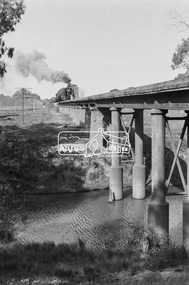
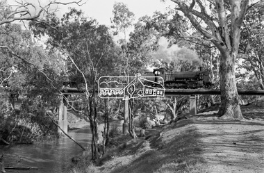
Photograph, Steam locomotive K-158 crossing the railway bridge over the Campaspe River at Rochester, Victoria, c.November 1963, 1963
... Steam locomotive K-158 crossing the railway bridge over the Campaspe River at Rochester, Victoria, c.November 1963...It is the railway bridge over the Campaspe River at Rochester, Vic. original to the construction of the line. ...Eltham District Historical Society Inc 728 Main Rd Eltham melbourne It is the railway bridge over the Campaspe River at Rochester, Vic. original to the construction of the line. ...It is the railway bridge over the Campaspe River at Rochester, Vic. original to the construction of the line. It was taken late on a Saturday morning and shows the regular goods train of that period approaching, then crossing the bridge. I originally planned to take just one view. The approaching train was first then it was a rapid run back along the raised river bank to get the broadside shot. I had little time to steady myself or properly check camera settings, hence the slightly soft focus etc. The train would eventually continue over the Echuca Iron Bridge into NSW. I think its ultimate destination was Deniliquin but not sure.Digital TIFF file Scan of 35mm Ilford FP3 black and white negative transparencygeorge coop collection, k-158, k-class steam locomotive (vr newport workshops), railway bridge, campaspe river, rochester -
 Eltham District Historical Society Inc
Photograph, Steam locomotive K-158 crossing the railway bridge over the Campaspe River at Rochester, Victoria, c.November 1963, 1963
... Steam locomotive K-158 crossing the railway bridge over the Campaspe River at Rochester, Victoria, c.November 1963...It is the railway bridge over the Campaspe River at Rochester, Vic. original to the construction of the line. ...Eltham District Historical Society Inc 728 Main Rd Eltham melbourne It is the railway bridge over the Campaspe River at Rochester, Vic. original to the construction of the line. ...It is the railway bridge over the Campaspe River at Rochester, Vic. original to the construction of the line. It was taken late on a Saturday morning and shows the regular goods train of that period approaching, then crossing the bridge. I originally planned to take just one view. The approaching train was first then it was a rapid run back along the raised river bank to get the broadside shot. I had little time to steady myself or properly check camera settings, hence the slightly soft focus etc. The train would eventually continue over the Echuca Iron Bridge into NSW. I think its ultimate destination was Deniliquin but not sure.Digital TIFF file Scan of 35mm Ilford FP3 black and white negative transparencygeorge coop collection, k-158, k-class steam locomotive (vr newport workshops), railway bridge, campaspe river, rochester -
 Sunshine and District Historical Society Incorporated
Photograph - Campaspe Run, 1999
... Campaspe...Campaspe Run...Campaspe A collection of 20 photographs taken during a field trip to Capaspe Run Campaspe Run Photograph Campaspe Run ...A collection of 20 photographs taken during a field trip to Capaspe Runcampaspe -
 Bendigo Historical Society Inc.
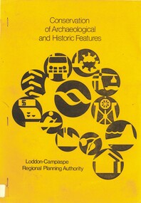
Book - CONSERVATION OF ARCHAEOLOGICAL AND HISTORIC FEATURES, 1977
... Conservation of archaeological and historic features Loddon-Campaspe Regional Planning Authority. 51 pages, with photos, and maps....Loddon Campaspe Regional Planning Authority...History House 11 Mackenzie Street Bendigo goldfields BENDIGO Buildings historic and archaeological heritage history buildings historic features heritage features Loddon Campaspe Regional Planning Authority Conservation of archaeological and historic features Loddon-Campaspe Regional Planning Authority. 51 pages, with photos, and maps. ...Conservation of archaeological and historic features Loddon-Campaspe Regional Planning Authority. 51 pages, with photos, and maps.Loddon Campaspe Regional Planning Authoritybendigo, buildings, historic and archaeological, heritage, history, buildings, historic features, heritage features -
 Bendigo Historical Society Inc.
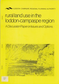
Book - RURAL LAND USE IN THE LODDON-CAMPASPE REGION, 1976
... RURAL LAND USE IN THE LODDON-CAMPASPE REGION - a discussion paper on issues and options. 30 pages, with maps....Loddon-Campaspe regional planning authority...History House 11 Mackenzie Street Bendigo goldfields BOOK Rural land use loddon campaspe rural land use agriculture Loddon-Campaspe regional planning authority RURAL LAND USE IN THE LODDON-CAMPASPE REGION - a discussion paper on issues and options. 30 pages, with maps. ...RURAL LAND USE IN THE LODDON-CAMPASPE REGION - a discussion paper on issues and options. 30 pages, with maps.Loddon-Campaspe regional planning authoritybook, rural, land use, loddon campaspe, rural, land use, agriculture -
 Port of Echuca
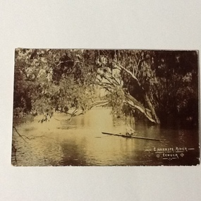
A black and white photographic postcard, Between 08/1906 - 10/1906
... Photographic Postcards were very popular in the early 20th century and this shows the Campaspe river, Echuca in flood. The high water mark is exemplified by having the rower on the water. ...Black and white photographic postcard showing the Campaspe river, Echuca, in flood, with a man rowing a racing scull....On face : "Campaspe River, Echuca". On reverse: printed in ink :" Post Card. ...Campaspe River, Echuca Echuca flood, 1906 Rowing, echuca On face : "Campaspe River, Echuca". ...Photographic Postcards were very popular in the early 20th century and this shows the Campaspe river, Echuca in flood. The high water mark is exemplified by having the rower on the water. The water has inundated the surrounding bush with trees partly submerged along the right hand side of the photograph.Rowing clubs were popular in towns along the Murray river and this picturesque scene of the Campaspe river , Echuca in flood shows a man rowing a racing scull down the river.Black and white photographic postcard showing the Campaspe river, Echuca, in flood, with a man rowing a racing scull.On face : "Campaspe River, Echuca". On reverse: printed in ink :" Post Card. This space may be used for correspondence. For address only. Place penny stamp here." In pencil is written: "Aug Sep Oct 1906 Flood" "Donation H V Evans 85 Fullers Rd Chatswood NSW." " Echuca Regional Library" is stamped but has been crossed out in pen.campaspe river, echuca, echuca flood, 1906, rowing, echuca -
 Malmsbury Historical Society
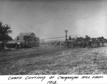
Photograph (Item), B/W Photo Of Chaff Cutting At Campaspe Mill Farm, Malmsbury 1913
... B/W Photo Of Chaff Cutting At Campaspe Mill Farm, Malmsbury 1913...B/W Photo Of Chaff Cutting At Campaspe Mill Farm, Malmsbury 1913 Photograph Photograph ...Buildings - "Hay Stack, Chaff Cutter" People - "Ward, Betty (Mrs.)" -
University of Melbourne, Burnley Campus Archives
Certificate - Documents and correspondence, The University of Melbourne, Congratulatory certificates, correspondence, plaques and cards for the Centenary of VCAH Burnley Campus 1991, 1991
... Mostly signed by chancellors, vice-chancellors, councils, chairmen, presidents, deans and directors, 1/ The University of New South Wales certificate July 1991 2/ The Royal Horticultural Society of Victoria 3/ Charles Sturt University 26 June 1991 4/ The Royal Horticultural Society 1891-1991 5/ Massey University, New Zealand July 1991 6/ Monash University 7/ The University of Melbourne 8/ Garden Advisory Service (card) 9/ The School of Mines and Industries Ballarat 10/ Outer Eastern College of Technical and Further Education (letter from Maurie Curwood Director 1/7/1991) 11/ Northern Metropolitan College of Tafe (letter from Brian J McDonald, Director 11/7/1991 12/ Curtin University of Technology 13/ Murdoch University 14/ University of Hawaii 15/ Victotria University of Technology (Letter to Mr R G Luff from G.J Allen) 16/ University of Canberra 12/7/1991 17/ Victorian Farmers Federation (letter froom Alex Arbuthnot President) 18/ Ballarat University College 19/ Deakin University 20/ Northern Territory University 21/ Victoria College 8/5/1991 22/ University of California Santa Barbara (Letter 1/7/1991) 23/ Landscape Contractors Association of Victoria Limited (letter) 24/ University of Adelaide 25/ University of Tasmania ========================BOX 222 26/ The University of Sydney 27/ Australian Catholic University 28/ University of Western Sydney (Hawkesbury) 29/ Griffith University 30/ The University of Wollongong (Letter and certificate) 31/ The University of Queensland 32/ Macquarie University 33/ James Cook University of North Queensland 34/ California Polytechnic State College, Wood and perspex Plaque 35/ Marcus Oldham Farm Management College, Wood plaque with metal coat of arms ============BOX 223 36/ THe University of Western Australia (Certificate in tube) 37/ Loddon Campaspe College of TAFE (Certificate in tube) 38/ Latrobe University (certificate in tube) 39/ Taranaki Polytechnic New Plymouth New Zealand 40/ Warwickshire College of Agriculture (made in UK, Wooden and painted coat of arms on plaque, in Box Heraldic Shield, Painted by hand) 41/ Massey University NZ (Wooden and painted coat of arms on plaque - in addition to (5) certificate) 42/ Ballarat University College ( Metal and wooden coloured plaque in addition to letter (18) ......Loddon Campaspe College of Tafe...Mostly signed by chancellors, vice-chancellors, councils, chairmen, presidents, deans and directors, 1/ The University of New South Wales certificate July 1991 2/ The Royal Horticultural Society of Victoria 3/ Charles Sturt University 26 June 1991 4/ The Royal Horticultural Society 1891-1991 5/ Massey University, New Zealand July 1991 6/ Monash University 7/ The University of Melbourne 8/ Garden Advisory Service (card) 9/ The School of Mines and Industries Ballarat 10/ Outer Eastern College of Technical and Further Education (letter from Maurie Curwood Director 1/7/1991) 11/ Northern Metropolitan College of Tafe (letter from Brian J McDonald, Director 11/7/1991 12/ Curtin University of Technology 13/ Murdoch University 14/ University of Hawaii 15/ Victotria University of Technology (Letter to Mr R G Luff from G.J Allen) 16/ University of Canberra 12/7/1991 17/ Victorian Farmers Federation (letter froom Alex Arbuthnot President) 18/ Ballarat University College 19/ Deakin University 20/ Northern Territory University 21/ Victoria College 8/5/1991 22/ University of California Santa Barbara (Letter 1/7/1991) 23/ Landscape Contractors Association of Victoria Limited (letter) 24/ University of Adelaide 25/ University of Tasmania ========================BOX 222 26/ The University of Sydney 27/ Australian Catholic University 28/ University of Western Sydney (Hawkesbury) 29/ Griffith University 30/ The University of Wollongong (Letter and certificate) 31/ The University of Queensland 32/ Macquarie University 33/ James Cook University of North Queensland 34/ California Polytechnic State College, Wood and perspex Plaque 35/ Marcus Oldham Farm Management College, Wood plaque with metal coat of arms ============BOX 223 36/ THe University of Western Australia (Certificate in tube) 37/ Loddon Campaspe College of TAFE (Certificate in tube) 38/ Latrobe University (certificate in tube) 39/ Taranaki Polytechnic New Plymouth New Zealand 40/ Warwickshire College of Agriculture (made in UK, Wooden and painted coat of arms on plaque, in Box Heraldic Shield, Painted by hand) 41/ Massey University NZ (Wooden and painted coat of arms on plaque - in addition to (5) certificate) 42/ Ballarat University College ( Metal and wooden coloured plaque in addition to letter (18) Congratulatory certificates, correspondence, plaques and cards for the Centenary of VCAH Burnley Campus 1991 Certificate Documents and correspondence The University of Melbourne Monash University Massey University, New Zealand Garden Advisory Service The Royal Horticultural Society of Victoria Royal Horticultural Society Charles Sturt University The University of New South Wales The School of Mines and Industries Ballarat Outer Eastern College Northern Metropolitan College of Tafe Curtin University of Technology Murdoch University University of Hawaii Victoria College Victoria University of Technology University of Canberra Victorian Farmers Federation Ballarat University College Deakin University Northern Territory University University of California Santa Barbara Landscape Contractors Association of Victoria University of Adelaide University of Tasmania The University of Sydney Australian Catholic University University of Western Sydney Griffith University The University of Wollongong James Cook University California Polytechnic Marcus Oldham Farm Management College The University of Western Australia Loddon Campaspe College of Tafe Latrobe University Warwickshire College of Agriculture Taranki Polytechnic NZ ...Acknowledgement from 40 associations and universities to congratulate the VCAH Burnley Campus for a centenary of education 1891-1991.42 items. Multiple greetings, congratulatory letters, certificates and plaques sent to VCAH Burnley Campus (Director Mr R G Luff) as a record of the campus' revered place in higher education 1891-1991. Mostly signed by chancellors, vice-chancellors, councils, chairmen, presidents, deans and directors, 1/ The University of New South Wales certificate July 1991 2/ The Royal Horticultural Society of Victoria 3/ Charles Sturt University 26 June 1991 4/ The Royal Horticultural Society 1891-1991 5/ Massey University, New Zealand July 1991 6/ Monash University 7/ The University of Melbourne 8/ Garden Advisory Service (card) 9/ The School of Mines and Industries Ballarat 10/ Outer Eastern College of Technical and Further Education (letter from Maurie Curwood Director 1/7/1991) 11/ Northern Metropolitan College of Tafe (letter from Brian J McDonald, Director 11/7/1991 12/ Curtin University of Technology 13/ Murdoch University 14/ University of Hawaii 15/ Victotria University of Technology (Letter to Mr R G Luff from G.J Allen) 16/ University of Canberra 12/7/1991 17/ Victorian Farmers Federation (letter froom Alex Arbuthnot President) 18/ Ballarat University College 19/ Deakin University 20/ Northern Territory University 21/ Victoria College 8/5/1991 22/ University of California Santa Barbara (Letter 1/7/1991) 23/ Landscape Contractors Association of Victoria Limited (letter) 24/ University of Adelaide 25/ University of Tasmania ========================BOX 222 26/ The University of Sydney 27/ Australian Catholic University 28/ University of Western Sydney (Hawkesbury) 29/ Griffith University 30/ The University of Wollongong (Letter and certificate) 31/ The University of Queensland 32/ Macquarie University 33/ James Cook University of North Queensland 34/ California Polytechnic State College, Wood and perspex Plaque 35/ Marcus Oldham Farm Management College, Wood plaque with metal coat of arms ============BOX 223 36/ THe University of Western Australia (Certificate in tube) 37/ Loddon Campaspe College of TAFE (Certificate in tube) 38/ Latrobe University (certificate in tube) 39/ Taranaki Polytechnic New Plymouth New Zealand 40/ Warwickshire College of Agriculture (made in UK, Wooden and painted coat of arms on plaque, in Box Heraldic Shield, Painted by hand) 41/ Massey University NZ (Wooden and painted coat of arms on plaque - in addition to (5) certificate) 42/ Ballarat University College ( Metal and wooden coloured plaque in addition to letter (18) 1991 centenary, vcah burnley, burnley centenary, congratulations, greeting certificates -
 Returned Nurses RSL Sub-branch
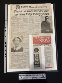
Newspaper - Newspaper clipping, [Campaspe News], War-time sweethearts' love survives long, lonely years, [c1995]
... [Campaspe News]...War-time sweethearts' love survives long, lonely years Newspaper Newspaper clipping [Campaspe News] Janet Webb ...Mary Everard met Lance Gibson met in South Australia when Lance and a mate rang the local hospital to see if there were any off duty nurses who would go to the pictures with them. After several other outings the pair both ended up travelling on the Queen Elizabeth I to Egypt, Mary as nurse in the Australian Army Nursing Service and Lance as a lieutenant in the 2/3rd Australian Machine Gun Battalion. After spending much of the three week journey together, they continued to spend what free time they had together. When Lance found out he was to ship out to Indonesia in January 1942 the couple came to an understanding that they would marry after war. Several weeks after Lance's departure, Mary's unit returned to Australia on the Strathallen, where they nursed in hospitals in Queensland. Lance became a POW of the Japanese, one of the lucky 72 out of 257 Australians in his group to survive the war. Mary and Lance were married in November 1946 and now have three children and eight grandchildren.A large newspaper clipping featuring a large title, five columns of text and two black and white photos. One photo is of the face of a nurse in uniform, while the other photo is of a man in uniform.wwii, ww2, world war two, prisoner of war, mary gibson, gaza, middle east, sydney, concorde army hospital, brisbane, hughenden, darwin, atherton tablelands, java, dutch, cycle camp, singapore, japan, formosa, taiwan, nagasaki, american, korean, manchuria, ransom camp, govenor of singapore, russian, manila, red cross, vatican, nanneella -
Returned Nurses RSL Sub-branch
Newspaper - Newspaper clipping, [Campaspe News], War-time sweethearts' love survives long, lonely years, [c1995]
... [Campaspe News]...War-time sweethearts' love survives long, lonely years Newspaper Newspaper clipping [Campaspe News] Janet Webb ...Mary Everard met Lance Gibson met in South Australia when Lance and a mate rang the local hospital to see if there were any off duty nurses who would go to the pictures with them. After several other outings the pair both ended up travelling on the Queen Elizabeth I to Egypt, Mary as nurse in the Australian Army Nursing Service and Lance as a lieutenant in the 2/3rd Australian Machine Gun Battalion. After spending much of the three week journey together, they continued to spend what free time they had together. When Lance found out he was to ship out to Indonesia in January 1942 the couple came to an understanding that they would marry after war. Several weeks after Lance's departure, Mary's unit returned to Australia on the Strathallen, where they nursed in hospitals in Queensland. Lance became a POW of the Japanese, one of the lucky 72 out of 257 Australians in his group to survive the war. Mary and Lance were married in November 1946 and now have three children and eight grandchildren.A large newspaper clipping featuring a large title, five columns of text and two black and white photos. One photo is of the face of a nurse in uniform, while the other photo is of a man in uniform.wwii, ww2, world war two, prisoner of war, mary gibson, gaza, middle east, sydney, concorde army hospital, brisbane, hughenden, darwin, atherton tablelands, java, dutch, cycle camp, singapore, japan, formosa, taiwan, nagasaki, american, korean, manchuria, ransom camp, govenor of singapore, russian, manila, red cross, vatican, nanneella -
 Returned Nurses RSL Sub-branch
Newspaper - Newspaper clipping, Campaspe News, The day our war ended, 1995
... Campaspe News...The day our war ended Newspaper Newspaper clipping Campaspe News ...Mary Gibson is to be a special guest at the Victory in the Pacific 50th anniversary celebrations in Rochester.Three newspaper clippings stuck to a larger piece of paper. The top clipping is the name of the newspaper the clippings all presumably come from. The left side clipping is the title of the story, while the right side slipping is the story.wwii, ww2, world war two, mary everand, rochester rsl wall of remembrance, les anderson, lockington, lockington wall of remembrance -
 Bendigo Historical Society Inc.
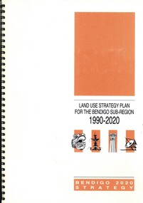
Book - LAND USE STRATEGY PLAN FOR THE BENDIGO SUV-REGION 1990-2020, 1991
... Prepared by three consulting firms for the Loddon-Campaspe Regional Planning Authority Inside front cover are: 1 Cover sheet, 3 stapled reports covering Bendigo 2020 land use strategy plan, Issues Report, Environment, also a 5 page booklet planning for the future with information and maps....Loddon-Campaspe Regional Planning Authority...History House 11 Mackenzie Street Bendigo goldfields BENDIGO Planning 2020 strategy. Loddon-Campaspe Regional Planning Authority Land Use Strategy Plan for the Bendigo Sub-Region, 1990 - 2020. ...Land Use Strategy Plan for the Bendigo Sub-Region, 1990 - 2020. Bendigo 2020 Strategy. Prepared by three consulting firms for the Loddon-Campaspe Regional Planning Authority Inside front cover are: 1 Cover sheet, 3 stapled reports covering Bendigo 2020 land use strategy plan, Issues Report, Environment, also a 5 page booklet planning for the future with information and maps.Loddon-Campaspe Regional Planning Authoritybendigo, planning, 2020 strategy. -
 Bendigo Historical Society Inc.
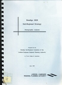
Book - BENDIGO 2020 SUB-REGIONAL STRATEGY, 1989
... .\ Prepared by Trevor Budge & Assoc for Bendigo Sub-Regional Committee of the Loddon-Campaspe Regional Planning Authority June 1989, 55 pages...Trevor Budge & Assoc for Bendigo Sub-Regional Committee of the Loddon-Campaspe Regional Planning Authority...Trevor Budge & Assoc for Bendigo Sub-Regional Committee of the Loddon-Campaspe Regional Planning Authority Bendigo 2020 Sub-Regional Strategy. ...Bendigo 2020 Sub-Regional Strategy. Demographic Analysis.\ Prepared by Trevor Budge & Assoc for Bendigo Sub-Regional Committee of the Loddon-Campaspe Regional Planning Authority June 1989, 55 pagesTrevor Budge & Assoc for Bendigo Sub-Regional Committee of the Loddon-Campaspe Regional Planning Authoritybendigo, council, future direction & strategies. -
Bendigo Historical Society Inc.
Map - CAMPASPE : COUNTY OF BENDIGO, 1964
... ...campaspe...Map. Campaspe, County of Bendigo, County of Rodney, Runnymede, Nolan, Muskerry, Toolleen, Colbinabbin, Campaspe River, Goornong, Mount Pleasant Creek. ...Map. Campaspe, County of Bendigo, County of Rodney, Runnymede, Nolan, Muskerry, Toolleen, Colbinabbin, Campaspe River, Goornong, Mount Pleasant Creek. ...Map. Campaspe, County of Bendigo, County of Rodney, Runnymede, Nolan, Muskerry, Toolleen, Colbinabbin, Campaspe River, Goornong, Mount Pleasant Creek. By authority A.C. Brooks, Government Printer, Melbourne. Drawn and reproduced at the Department of Lands and Survey, Melbourne. 1964. Price 10/- per sheet. (number 112 in map cupboard 1)A.C. Brooks, Government Printer, Melbourne.map, bendigo, campaspe -
 Bendigo Historical Society Inc.
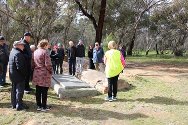
Bendigo Historical Society Walking Tour of Axedale, 1st Sept 2024
... ...campaspe...The town is nestled alongside the Campaspe River which feeds out of Lake Eppalock. ...Places visited included the Protestant and Catholic Cemeteries, the "Blue Stone House", the 150-year-old bridge over the Axe Creek on the Sugerloaf Road, the old Cobb and Co Stables, St Andrews Church and the Campaspe River Bridge....The town is nestled alongside the Campaspe River which feeds out of Lake Eppalock. ...Axedale is a town in Victoria, Australia. It is located on the McIvor Highway, in the City of Greater Bendigo, east of Bendigo. It was surveyed and proclaimed in 1861. At the 2021 census, Axedale had a population of 984. The town is nestled alongside the Campaspe River which feeds out of Lake Eppalock. It has a golf course, tennis courts, a school, a pub and a convenience store/petrol station. It lies between Heathcote and Bendigo.Forty photos taken on the walking tour of Axedale by the Bendigo Historical Society. Places visited included the Protestant and Catholic Cemeteries, the "Blue Stone House", the 150-year-old bridge over the Axe Creek on the Sugerloaf Road, the old Cobb and Co Stables, St Andrews Church and the Campaspe River Bridge.axedale, bendigo historical society walking tour, st andrews church axedale, axedale cemetery, axe creek bridge, campaspe, cobb and co stables axedale, blue stone house axedale -
 Uniting Church Archives - Synod of Victoria
BW photo, Undated
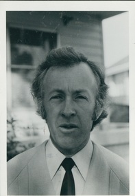
... One time Chairperson of Loddon-Campaspe Presbytery....J McOrist, Chairman Loddon Campaspe Presbytery. Church and Nation 24 May ? ...One time Chairperson of Loddon-Campaspe Presbytery. Rev. John (Jock) McOrist; Cobram, Wedderburn, Foster, Melbourne, Albert Park, Bendigo West, Albury, Black Rock; Retired 1996 J McOrist, Chairman Loddon Campaspe Presbytery. ...Ordained 1961. Parishes: Cobram 1952, Wedderburn 1953, Foster 1956, Foster-Torra 1957–59, Womboota-Mathoura 1960–61, Port Melbourne 1962, Albert Park 1963–66, Cohuna 1967–70, Bendigo West 1971–78, Albury 1979–02/85, Black Rock 03/85. Retired 1996. One time Chairperson of Loddon-Campaspe Presbytery.Rev. John (Jock) McOrist: Head & shoulders portrait, standing adjacent to some steps. Wearing coat and tie.J McOrist, Chairman Loddon Campaspe Presbytery. Church and Nation 24 May ? p8rev. john (jock) mcorist; cobram, wedderburn, foster, melbourne, albert park, bendigo west, albury, black rock; retired 1996 -
 Uniting Church Archives - Synod of Victoria
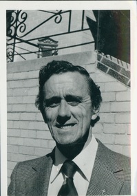
BW glossy photo, 1978
... Reverend Alistair Orton was ordained in 1962 as a Methodist minister, and served at Ulverstone, Latrobe, Rochester, Bendigo East, Secretary Loddon Campaspe Presbytery, Mentone, Burwood Heights. ...The Rev Alistair Orton Sec Loddon Campaspe Presbytery (East Bendigo) Church and Nation 24 May 1978 page 8...Reverend Alistair Orton was ordained in 1962 as a Methodist minister, and served at Ulverstone, Latrobe, Rochester, Bendigo East, Secretary Loddon Campaspe Presbytery, Mentone, Burwood Heights. ...Reverend Alistair Orton was ordained in 1962 as a Methodist minister, and served at Ulverstone, Latrobe, Rochester, Bendigo East, Secretary Loddon Campaspe Presbytery, Mentone, Burwood Heights. He retired in 1999. Of historical interest, his ancestor was the first Methodist minister to conduct worship in Victoria in colonial days.BW photo of Rev. Alistair Orton, upper body.The Rev Alistair Orton Sec Loddon Campaspe Presbytery (East Bendigo) Church and Nation 24 May 1978 page 8rev. alistair orton; methodist/uc minister; ulverstone, latrobe, rochester, bendigo east, mentone, burwood heights -
 Bendigo Historical Society Inc.
Map - PROPOSED TOWNSHIP PARISH OF CAMPASPE, 24th May 1875
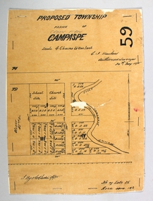
... ... Campaspe...Map: Proposed Township, Parish of Campaspe(This has been crossed out and 'Creek View' written above). ...History House 11 Mackenzie Street Bendigo goldfields MAP township Proposed Township Campaspe Creek View Map: Proposed Township, Parish of Campaspe(This has been crossed out and 'Creek View' written above). ...Map: Proposed Township, Parish of Campaspe(This has been crossed out and 'Creek View' written above). Hand Draughted Parish plan Stapled to the backingmap, township, proposed township, campaspe, creek view -
 Bendigo Historical Society Inc.
Map - PARISH OF CAMPASPE, November 1880
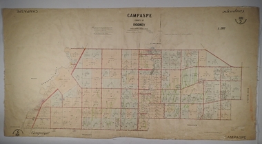
... ...Campaspe...Map: Parish of Campaspe, County of Rodney. Parish plan G.H.H. ...History House 11 Mackenzie Street Bendigo goldfields MAP Rodney parish plan Campaspe Map: Parish of Campaspe, County of Rodney. ...Map: Parish of Campaspe, County of Rodney. Parish plan G.H.H. Smith Draughtsman August 1880 Examined J.A. Morrison 7.10.80 Photo- Lithographed J. Noone. 1.11.80 Written in green " Cancelled 16.2.66."map, rodney, parish plan, campaspe -
 Bendigo Historical Society Inc.
Booklet - Aileen and John Ellison collection: Eppalock Reservoir
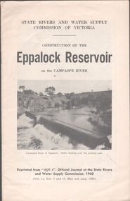
... Eppalock Reservoir was built between 1960 and 1964 and is the only reservoir on the Campaspe River. The main embankment is 700 meters long and 47 meters high. ...Booklet by the State Rivers and Water Supply Commission of Victoria - Construction of the Eppalock Reservoir on the Campaspe River. Reprinted from "Aqua", official journal of the State rivers and water supply commission, 1960 (Vol.11, Nos. 9 and 11, May and July, 1960)...History House 11 Mackenzie Street Bendigo goldfields Eppalock Reservoir was built between 1960 and 1964 and is the only reservoir on the Campaspe River. The main embankment is 700 meters long and 47 meters high. ...Eppalock Reservoir was built between 1960 and 1964 and is the only reservoir on the Campaspe River. The main embankment is 700 meters long and 47 meters high. It has a total capacity of 304,651 ML.Booklet by the State Rivers and Water Supply Commission of Victoria - Construction of the Eppalock Reservoir on the Campaspe River. Reprinted from "Aqua", official journal of the State rivers and water supply commission, 1960 (Vol.11, Nos. 9 and 11, May and July, 1960)lake eppalock, reservoir -
Whitehorse Historical Society Inc.
Article, City's Chief Executive Officer goes into retreat, 31/08/1988 12:00:00 AM
... He and his wife plan to run a seminar centre and executive retreat in Campaspe House, Woodend....He and his wife plan to run a seminar centre and executive retreat in Campaspe House, Woodend....He and his wife plan to run a seminar centre and executive retreat in Campaspe House, Woodend. City's Chief Executive Officer goes into retreat Article Article ...After five years as the City's Chief Executive Officer, Les Fell is to retire.After five years as the City's Chief Executive Officer, Les Fell is to retire. He looks back on his term with satisfaction, including his representation of Australia on the International City Management Association. He and his wife plan to run a seminar centre and executive retreat in Campaspe House, Woodend.After five years as the City's Chief Executive Officer, Les Fell is to retire. fell, les, fell, shirley, city of nunawading, local government -
 Bendigo Historical Society Inc.
Document - LODDON - CAMPASPE REGIONAL PLANNING AUTHORITY LETTER
... Two letters from the Loddon - Campaspe Regional Planning Authority the first dated 9th April, 1979 the second 12th April, 1979 both titled: annotated bibliograpghy of the Loddon-Campaspe Region. ...History House 11 Mackenzie Street Bendigo goldfields ORGANISATION Government loddon campaspe Two letters from the Loddon - Campaspe Regional Planning Authority the first dated 9th April, 1979 the second 12th April, 1979 both titled: annotated bibliograpghy of the Loddon-Campaspe Region. ...Two letters from the Loddon - Campaspe Regional Planning Authority the first dated 9th April, 1979 the second 12th April, 1979 both titled: annotated bibliograpghy of the Loddon-Campaspe Region. Also a map of the Loddon-Campaspe regional Autorithy area of study. Two stapled pages of the Annotated Bibliography of the Loddon - Campaspe Regionorganisation, government, loddon campaspe -
 Bendigo Historical Society Inc.
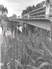
Photograph - PHOTOGRAPH. ELMORE, 1993
... Bridge over the Campaspe River at Elmore....Bridge over the Campaspe River at Elmore. Photograph PHOTOGRAPH. ...Photograph. Bridge over the Campaspe River at Elmore. -
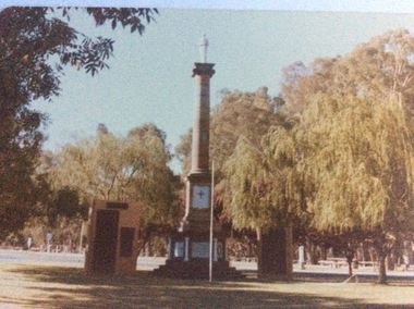 Port of Echuca
Colour photograph, 1979
... The memorial was moved some time in the 1960's to it's present site, which is now immediately surrounded by the Shire of Campaspe Echuca Library which was built in the early 2000's . ...The monument is situated at the northern end of Hare Street, near the intersection with Radcliffe St, and just east of the Shire of Campaspe offices....The memorial was moved some time in the 1960's to it's present site, which is now immediately surrounded by the Shire of Campaspe Echuca Library which was built in the early 2000's . ...This monument was originally situated on the median strip in High Street, outside the original Town Hall building, which subsequently became the town's Library, and is now the Shire Offices I.T Department. The memorial was moved some time in the 1960's to it's present site, which is now immediately surrounded by the Shire of Campaspe Echuca Library which was built in the early 2000's . The memorial now also mentions other wars of the 20th Century.The memorial now represents all people from the surrounding districts who have been lost to all Wars. The memorial is the focus of the Anzac Day ceremonies. In this photograph of 1979, both World War 1 & World War 2 would have been mentioned on the plaques.A coloured photograph of the World War 1 memorial in Echuca. The monument consists of a column with a statue of a soldier on the top. There are two plaque walls on both sides. There is a flag pole at centre front. . The monument is situated at the northern end of Hare Street, near the intersection with Radcliffe St, and just east of the Shire of Campaspe offices.Printed on the back are the words, "This paper manufactured by Kodak.world war 1., soldiers, civic centre, war memorial, world war 2