Showing 134 items matching "canterbury maps"
-
 Canterbury History Group
Map - Canterbury subdivisions, 1996
... Canterbury... Maps...Photocopy of map from Camberwell Library showing Canterbury subdivisions....Canterbury Maps Land subdivisions Photocopy of map from Camberwell Library showing Canterbury subdivisions. ...Photocopy of map from Camberwell Library showing Canterbury subdivisions.canterbury, maps, land subdivisions -
Canterbury History Group
Map - Camberwell and Boroondara, Melbourne and Metropolitan Board of Works, c.1905
... Canterbury... Maps...Canterbury History Group 190A Canterbury Road Canterbury melbourne Canterbury Maps Melbourne and Metropolitan Board of Works Copy of Melbourne and Metropolitan Board of Works Plan no. 71 for Camberwell and Boroondara Map Camberwell and Boroondara Melbourne and Metropolitan Board of Works ...Copy of Melbourne and Metropolitan Board of Works Plan no. 71 for Camberwell and Boroondaracanterbury, maps, melbourne and metropolitan board of works -
Canterbury History Group
Map - Milk delivery areas for Camberwell
... ... Canterbury... Maps...Canterbury History Group 190A Canterbury Road Canterbury melbourne Map showing the delivery areas for dairies in Camberwell Camberwell Canterbury Maps Dairies Goddards Dairy Youngs Dairy A 3 2 pages Map Milk delivery areas for Camberwell. ...Map showing the delivery areas for dairies in CamberwellA 3 2 pagescamberwell, canterbury, maps, dairies, goddards dairy, youngs dairy -
Canterbury History Group
Article - Early history of Canterbury
... Canterbury maps...Includes origin of names. Canterbury maps Lord Canterbury 7 printed A4 pages, (4 both sides) Article Early history of Canterbury ...7 printed A4 pages, (4 both sides)canterbury maps, lord canterbury -
Canterbury History Group
Document - Canterbury Bowling Club - Agreement, 1935
... Maps... Canterbury...Hislop, trustees of the Canterbury Bowling Club, 1935. Includes map of land to be occupied....Hislop, trustees of the Canterbury Bowling Club, 1935. Includes map of land to be occupied. ...Agreement between The Mayor, Councillors and Citizens of the City of Camberwell and Messrs A.G. Greenham and A .McK. Hislop, trustees of the Canterbury Bowling Club, 1935. Includes map of land to be occupied.canterbury bowling club, kendall street, city of camberwell, scott street, canterbury gardens, greenham> arthur george, hislop> arthur mckenzie, maps, canterbury -
Whitehorse Historical Society Inc.
Map, Nunawading Shire, 1892
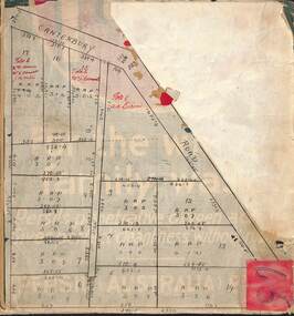
... One map (Blackburn) from north of Whitehorse Road to Highbury Road, 2nd map (Mitcham) Bulleen to south of Canterbury Road; 3rd map Whitehorse Road to Highbury Road....One map (Blackburn) from north of Whitehorse Road to Highbury Road, 2nd map (Mitcham) Bulleen to south of Canterbury Road; 3rd map Whitehorse Road to Highbury Road....One map (Blackburn) from north of Whitehorse Road to Highbury Road, 2nd map (Mitcham) Bulleen to south of Canterbury Road; 3rd map Whitehorse Road to Highbury Road. ...Photocopy of an enlargement of map of Shire of Nunawading showing landowners in 1892.Photocopy of an enlargement of map of Shire of Nunawading showing landowners in 1892. Covers Middleborough Road to Ringwood boundary. One map (Blackburn) from north of Whitehorse Road to Highbury Road, 2nd map (Mitcham) Bulleen to south of Canterbury Road; 3rd map Whitehorse Road to Highbury Road.Photocopy of an enlargement of map of Shire of Nunawading showing landowners in 1892. maps, shire of nunawading, blackburn, blackburn south, nunawading, forest hill, vermont, mitcham, vermont south -
Canterbury History Group
Article, Don Gibb, The Elgar's Special Survey
... Copy of a talk given by Don Gibb to the Canterbury History Group in June 2015 on the Elgar Survey which will be the basis of the second chapter of his forthcoming book on the social history of Canterbury. Includes maps and a list of the first Boroondara ratepayers....Canterbury History Group 190A Canterbury Road Canterbury melbourne Canterbury McWilliam. Gwen Land Subdivision Port Phillip District Maps Gibb> Don Copy of a talk given by Don Gibb to the Canterbury History Group in June 2015 on the Elgar Survey which will be the basis of the second chapter of his forthcoming book on the social history of Canterbury. ...Copy of a talk given by Don Gibb to the Canterbury History Group in June 2015 on the Elgar Survey which will be the basis of the second chapter of his forthcoming book on the social history of Canterbury. Includes maps and a list of the first Boroondara ratepayers.canterbury, mcwilliam. gwen, land subdivision, port phillip district, maps, gibb> don -
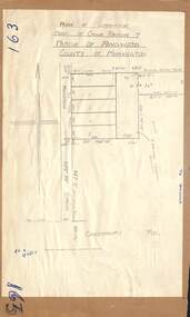
Canterbury History Group
Map - Victorian Railways, Sheet no.10 , Hawthorn to Canterbury, 1/02/1914 12:00:00 AM
... Map of Canterbury Railway Station and its surrounds, includes railway lines and station yards and may houses in nearby streets, February 1914....Canterbury History Group 190A Canterbury Road Canterbury melbourne Canterbury Canterbury Railway Station Canterbury Road Maling Road Bowling Green Canterbury Gardens Stationmasters Houses Scott Crescent Victorian Railways Map of Canterbury Railway Station and its surrounds, includes railway lines and station yards and may houses in nearby streets, February 1914. ...Map of Canterbury Railway Station and its surrounds, includes railway lines and station yards and may houses in nearby streets, February 1914.canterbury, canterbury railway station, canterbury road, maling road, bowling green, canterbury gardens, stationmasters houses, scott crescent, victorian railways -
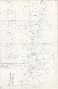 Bendigo Historical Society Inc.
Map - BELLE VUE NO 2 - PLAN OF LEASES
... Canterbury Co, Platus Co, S. Platus Co, Golden Fleece United, Alfred Co, Iron Duke Co, Victoria Gold Mines Co, Hercules Co and Iron Bark. Notes prepared by Albert Richardson. Map ...BHS CollectionPlan of Mining Leases from Rowan Street to Long Gully. Reference J. N. Macartney 2nd Edition Bendigo Goldfields Registry for 1872. Names of Leases are: Moore ?, Ellesmere Co, Bonati & Co, Dennis, Abe Lincoln Co, Lansell & Hunt, Black & White Lead Co, Koch & Hildebrand, Ballerstedt, Lazarus Co No 1, Lazarus Co, Watson, Lazarus Freehold, Lazarus Co No 2, Lazarus Tribute, South Extended Burra, Endeavor Co, Old Chum Co, Burrows and Sterry, New Chum & Victoria Trib, Jackson, North Old Wybrants Chum Co, Myra Co, McLenn, Geary & Co, Western Victoria Hill G. M. Co, Victoria Reef G.M.Co, South Adventure Co, South Try Me Well, W. Rae, Wells Midway, Extended Co, Handy Andy, Moonta Co, Humboldt Co, Adventure Co, Try Me Well, Sterry & Co, Midway, Tudor, Friedman's Reef, Rising Sun, Try Me Luck, Pomponia, Confidence Co, Alfred Co, Advance Co, Prince Alfred Co, Canterbury Co, Platus Co, S. Platus Co, Golden Fleece United, Alfred Co, Iron Duke Co, Victoria Gold Mines Co, Hercules Co and Iron Bark. Notes prepared by Albert Richardson.map, bendigo, mining plan, belle vue no 2, no 2 belle vue new chum & c, j n macartney bendigo goldfields registry 1872, moore ?, ellesmere co, bonati & co, dennis, abe lincoln co, lansell & hunt, black & white lead co, koch & hildebrand, ballerstedt, lazarus co no 1, lazarus co, watson, lazarus freehold, lazarus co no 2, lazarus tribute, south extended burra, endeavor co, old chum co, burrows and sterry, new chum & victoria trib, jackson, north old wybrants chum co, myra co, mclenn, geary & co, western victoria hill g. m. co, victoria reef g.m.co, south adventure co, south try me well, w. rae, wells midway, extended co, handy andy, moonta co, humboldt co, adventure co, try me well, sterry & co, midway, tudor, friedman's reef, rising sun, try me luck, pomponia, confidence co, alfred co, advance co, prince alfred co, canterbury co, platus co, s. platus co, golden fleece united, alfred co, iron duke co, victoria gold mines co, hercules co, iron bark -
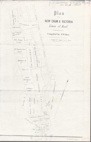 Bendigo Historical Society Inc.
Map - NEW CHUM & VICTORIA LINES OF REEF - PLAN OF NEW CHUM & VICTORIA LINES OF REEF
... MAP...goldfields...New Chum & Victoria Lines of Reef... Victoria Catharine G M Coy... Thornton & Co... Extd Victoria Reef G M Co... Ural Tribute Compy... Nil Desperandum Compy... Koch... North Victoria G M Co... Danger Hill Coy... North Endeavour Coy... Wheadon & Co... Pilot Co... North Energetic Co... Energetic Compy... Endeavour Company... Hercules Co... Victoria Gold Mines Compy... Iron Duke G M Co... Golden Fleece United... Ballerstedt... Alfred Co... Confidence Co... Prince Alfred Co... Canterbury...History House 11 Mackenzie Street Bendigo goldfields MAP goldfields New Chum & Victoria Lines of Reef Victoria Catharine G M Coy Thornton & Co Extd Victoria Reef G M Co Ural Tribute Compy Nil Desperandum Compy Koch North Victoria G M Co Danger Hill Coy North Endeavour Coy Wheadon & Co Pilot Co North Energetic Co Energetic Compy Endeavour Company Hercules Co Victoria Gold Mines Compy Iron Duke G M Co Golden Fleece United Ballerstedt Alfred Co Confidence Co Prince Alfred Co Canterbury Co Advance Co Wells Humboldt Co Adventure Co Try Me Well Sterry & Co Gibbs & Ballerstedt Handy Andy Wells? ...Two pages of a Plan of New Chum & Victoria Lines of Reef, compiled by G. W. Hart. Taken from J. N. Macartney's G'Fields Registry for 1871. Plan shows leases from High Street to California Gully. Location of the Manchester Arms, British & American Hotel and the Quartz Miners Arms are shown. Townships of Long Gully and Ironbark are shown.map, goldfields, new chum & victoria lines of reef, victoria catharine g m coy, thornton & co, extd victoria reef g m co, ural tribute compy, nil desperandum compy, koch, north victoria g m co, danger hill coy, north endeavour coy, wheadon & co, pilot co, north energetic co, energetic compy, endeavour company, hercules co, victoria gold mines compy, iron duke g m co, golden fleece united, ballerstedt, alfred co, confidence co, prince alfred co, canterbury co, advance co, wells, humboldt co, adventure co, try me well, sterry & co, gibbs & ballerstedt, handy andy, wells?, south adventure co, w rae, victoria reef quartz m co, myra co, jackson, wybrants, burrows & sterry, new chum & victoria tribute, old chum co, ballerstedt, lazarus, watson, koch & hildebrand, lansell & hunt, dennis, abe lincoln co, bonati & co, ellesmere co, moore late menzies, british co, british tribute co, garibaldi, c c co, new chum trib, dobson & co, young chum co, little chum co, old chum co, new chum trib, little chum trib, g w hart, j n macartney's g'fields registry for 1871, manchester arms, british & american, quartz miners arms -
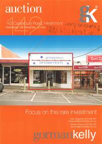 Ringwood and District Historical Society
Flyer, Auction - 142 Canterbury Road, Heathmont, Victoria (Circa 2010)
... map on Side 2. Auction date Wednesday 10th November (2010?). Auction - 142 Canterbury Road, Heathmont, Victoria (Circa 2010) Flyer ...A4 size double sided advertisement for auction of investment property. Colour exterior view on Side 1 and shopping strip street view with location map on Side 2. Auction date Wednesday 10th November (2010?).Detailed description on Side 2 includes 5 year lease; currently returning $22,977 net p.a. plus GST and outgoings. Excellent position surrounded by major retailers including IGA, Baker's Delight,Retravision and Commonwealth Bank. Abundant customer parking within the surrounding area. Building area: 85.1 sqm, Land area: 160sqm, Zoning: Business 1. Heathmont Railway Station only a short walk away. Agents - Gorman Kelly Licensed Estate Agents, Auctioneers & Property Managers, 1 Oxley Road Hawthorn, Vic 3122. Telephone 03 9810 7200 Facsimile 03 9810 7299. -
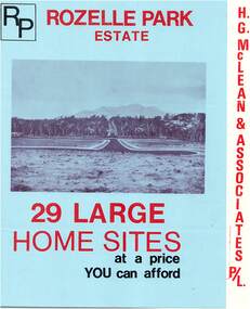 Ringwood and District Historical Society
Flyer, Subdivisional Land Sale Brochure, Rozelle Park Estate, Ringwood East, Vic. - circa 1968
... Canterbury Road, Heathmont. Phone 870 3422 A/H 870 5879. Folded land subdivision sale advertisement for 29 home sites, with location map and summary of local facilities and services. ...Folded land subdivision sale advertisement for 29 home sites, with location map and summary of local facilities and services. Separate price list leaflet enclosed with terms of sale.Subdivision includes Wingate Avenue and Rozelle Avenue, Ringwood East. Agent - H.G. McLean & Associates Pty. Ltd., 166 Canterbury Road, Heathmont. Phone 870 3422 A/H 870 5879. -
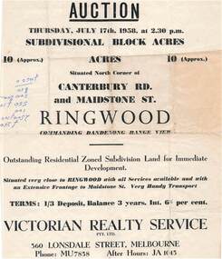 Ringwood and District Historical Society
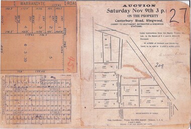
Flyer - Land Auction Sale, Ten Acres, Maidstone Street Ringwood - 1958
... Canterbury Road and Maidstone Street, Ringwood. Agents - Victorian Realty Service Pty.Ltd., 360 Lonsdale Street, Melbourne, Phone MU7858, After Hours JA1045. Reverse side shows map...Canterbury Road and Maidstone Street, Ringwood. Agents - Victorian Realty Service Pty.Ltd., 360 Lonsdale Street, Melbourne, Phone MU7858, After Hours JA1045. Reverse side shows map ...Double sided page advertising Auction, Thursday, July 17th, 1958, (Approx.) 10 Acres, north corner of Canterbury Road and Maidstone Street, Ringwood. Agents - Victorian Realty Service Pty.Ltd., 360 Lonsdale Street, Melbourne, Phone MU7858, After Hours JA1045. Reverse side shows map of proposed subdivision by K.J. Noonan & Co., Surveyors & Engineers, 495 St.Kilda Rd, Melbourne, marked subject to approval of all interested statutory authorities.Residential zoned subdivision land for immediate development. Extensive frontage to Maidstone Street. Accompanying handwritten annotation "10 acres offered as a whole, later re-subdivided". -
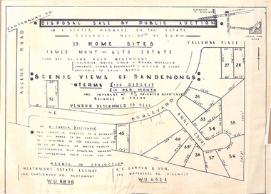 Ringwood and District Historical Society
Flyer - Auction, Mont-Alto Estate, Heathmont, Victoria - circa 1960
... map of subdivsion, terms of sale, and reference to brick covenant. Subdivision includes Yallamba Place, The Boulevard, and Anne Court, Heathmont. Agents - Heathmont Estate Agency, 103 Canterbury...map of subdivsion, terms of sale, and reference to brick covenant. Subdivision includes Yallamba Place, The Boulevard, and Anne Court, Heathmont. Agents - Heathmont Estate Agency, 103 Canterbury ...Single page advertisement for auction of 13 home sites on Saturday 30th November (1957?) with map of subdivsion, terms of sale, and reference to brick covenant. Subdivision includes Yallamba Place, The Boulevard, and Anne Court, Heathmont. Agents - Heathmont Estate Agency, 103 Canterbury Road, Heathmont (Telephone) WU6808, and C.E. Carter & Son, 126 Whitehorse Road, Ringwood, WU6024. Auctioneer - Mr. A. Carter."This Estate is subject to a covenant that all homes to be erected must be a minimum of 12-1/2 squares and are to be of brick or brick veneer construction, thus ensuring owners of preserving their value for the future." -
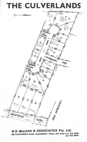 Ringwood and District Historical Society
Document, Subdivision Plan - The Culverlands Estate, Heathmont, Victoria (undated, circa 1968)
... Map of residential allotments for sale, with handwritten pricing notations and some marked "Sold". Subdivision includes Culverlands Road, Swain Court, Pleasant Drive, Barbara Court, and Armstrong Road, Heathmont. Agent - H.G. McLean & Associates Pty. Ltd., 166 Canterbury...Map of residential allotments for sale, with handwritten pricing notations and some marked "Sold". Subdivision includes Culverlands Road, Swain Court, Pleasant Drive, Barbara Court, and Armstrong Road, Heathmont. Agent - H.G. McLean & Associates Pty. Ltd., 166 Canterbury ...Map of residential allotments for sale, with handwritten pricing notations and some marked "Sold". Subdivision includes Culverlands Road, Swain Court, Pleasant Drive, Barbara Court, and Armstrong Road, Heathmont. Agent - H.G. McLean & Associates Pty. Ltd., 166 Canterbury Road, Heathmont Vic., 3135, Telephones : 870-3422 A/hrs 870-5879 and 729-2809. -
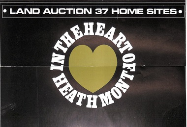 Ringwood and District Historical Society
Pamphlet, Land Auction Brochure - Heathmont Hills Estate, Heathmont, Vic
... Brochure includes terms of sale, description of subdivision features and local facilities, with locality map. Subdivision includes Canterbury Road, Cuthbert Street, and Craig Court, off Balfour Avenue, Heathmont. ...Brochure includes terms of sale, description of subdivision features and local facilities, with locality map. Subdivision includes Canterbury Road, Cuthbert Street, and Craig Court, off Balfour Avenue, Heathmont. ...Multi-fold brochure advertising auction of 37 home sites on Saturday May 6th, (1967?). Brochure includes terms of sale, description of subdivision features and local facilities, with locality map. Subdivision includes Canterbury Road, Cuthbert Street, and Craig Court, off Balfour Avenue, Heathmont. Agent - N.R. Reid & Co Pty Ltd., 173 Coleman Parade, Glen Waverley, (phone) 560 0355 A.H. 28 3185, in conjunction with H.G. McLean Pty Ltd., 166 Canterbury Road, Heathmont, 87 7808 A.H. 842 2708. -
 Ringwood and District Historical Society
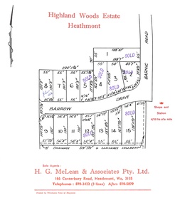
Document, Subdivision Plan - Highland Woods Estate, Heathmont, Victoria (undated, circa 1968)
... Map of 15 residential allotments for sale, with seven rubber-stamped SOLD and one with handwritten notation "$5650 1968". Subdivision includes Barrow Drive and Barnic Road, Heathmont. Agent - H.G. McLean & Associates Pty. Ltd., 166 Canterbury...Ringwood and District Historical Society 125A Warrandyte Road Ringwood North melbourne Map of 15 residential allotments for sale, with seven rubber-stamped SOLD and one with handwritten notation "$5650 1968". Subdivision includes Barrow Drive and Barnic Road, Heathmont. Agent - H.G. McLean & Associates Pty. Ltd., 166 Canterbury ...Map of 15 residential allotments for sale, with seven rubber-stamped SOLD and one with handwritten notation "$5650 1968". Subdivision includes Barrow Drive and Barnic Road, Heathmont. Agent - H.G. McLean & Associates Pty. Ltd., 166 Canterbury Road, Heathmont Vic., 3135, Telephones : 870-3422 A/hrs 870-5879. -
 Ringwood and District Historical Society
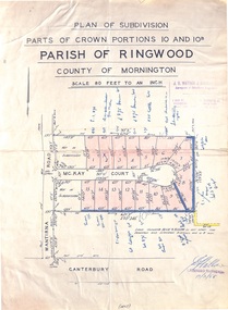
Map - Plan of Subdivision, Parts of Crown Portions 10 and 10B Parish of Ringwood - 1958
... Folded subdivision map of 15 residential allotments in McKay Court Ringwood, off Wantirna Road north of Canterbury Road. ...Ringwood and District Historical Society 125A Warrandyte Road Ringwood North melbourne Folded subdivision map of 15 residential allotments in McKay Court Ringwood, off Wantirna Road north of Canterbury Road. ...Folded subdivision map of 15 residential allotments in McKay Court Ringwood, off Wantirna Road north of Canterbury Road. Rubber stamped by Surveyors and Chartered Engineers J.S. Watson & Associates, Mornington and South Yarra, with illegible signature dated 17/2/58. Handwritten notations indicating allotment sale names and amounts or where passed in. Accompanying clipping on scrap paper backing from Land Sale Brochure with description of available services and local facilities and terms of sale - £75 Deposit £10 Monthly. -
 Ringwood and District Historical Society
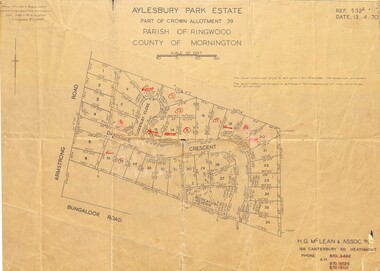
Map - Plan of Subdivision, Aylesbury Park Estate, Part of Crown Allotment 39, Parish of Ringwood, County of Mornington - 1970
... McLean & Assoc P/L, 166 Canterbury Road Heathmont, Phone 8703422 A.H. 8706726 8700112. Map showing residential allotments for sale in Armstrong Road, Danielle Crescent and Locksley Close, Heathmont, Victoria. ...Map showing residential allotments for sale in Armstrong Road, Danielle Crescent and Locksley Close, Heathmont, Victoria.Ref.532A Date 13.4.70. Paul Millar & Associates, Land & Engineering Surveyors, 14A Main Street Croydon (Phone) 723 4493. Ref.532A Date 13.4.70. (Agent) H.G. McLean & Assoc P/L, 166 Canterbury Road Heathmont, Phone 8703422 A.H. 8706726 8700112. -
 Ringwood and District Historical Society
Document, Collage of Residential Subdivision Map Clippings - Ringwood, Victoria - (Undated, circa 1930s)
... maps - Five numbered allotments on unidentified section of Warrandyte Road, Ringwood. - 53 numbered allotments on Caroline Street and Henry Street off Greenwood Avenue, Ringwood. - Clipping from a land auction brochure for 40 acres in 3 and 4 acre lots marked as Miller's Estate - Miller Street off Canterbury Road, Heathmont, Vic....maps - Five numbered allotments on unidentified section of Warrandyte Road, Ringwood. - 53 numbered allotments on Caroline Street and Henry Street off Greenwood Avenue, Ringwood. - Clipping from a land auction brochure for 40 acres in 3 and 4 acre lots marked as Miller's Estate - Miller Street off Canterbury Road, Heathmont, Vic. ...Single page photocopy of 3 unrelated subdivision maps - Five numbered allotments on unidentified section of Warrandyte Road, Ringwood. - 53 numbered allotments on Caroline Street and Henry Street off Greenwood Avenue, Ringwood. - Clipping from a land auction brochure for 40 acres in 3 and 4 acre lots marked as Miller's Estate - Miller Street off Canterbury Road, Heathmont, Vic.(Auction) Under instructions from the Equity Trustee Co. Ltd., in the Estate of F.J. and K. Millar Deceased. -
 Ringwood and District Historical Society
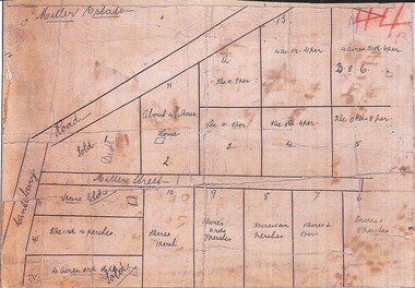
Map, Miller Estate, Heathmont, Victoria - (Undated, circa 1930s)
... Hand-drawn map of house and 17 residential allotments on Canterbury Road and Miller Street, Heathmont....Hand-drawn map of house and 17 residential allotments on Canterbury Road and Miller Street, Heathmont. ...Hand-drawn map of house and 17 residential allotments on Canterbury Road and Miller Street, Heathmont.Handwritten notations include allotment sizes, with some marked as Sold. -
 Ringwood and District Historical Society
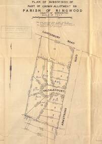
Map - Plan of Subdivision, Part of Crown Allotment 39, Parish of Ringwood, County of Mornington - (Undated, circa 1950)
... Map showing residential allotments numbered 1 to 13 on Valdale Court and Armstrong Road off Canterbury Road, Heathmont, Victoria....Map showing residential allotments numbered 1 to 13 on Valdale Court and Armstrong Road off Canterbury Road, Heathmont, Victoria. ...Map showing residential allotments numbered 1 to 13 on Valdale Court and Armstrong Road off Canterbury Road, Heathmont, Victoria. Richard Rogalsky, Land Surveyor and Town Planner, 25 Napier Street, Essendon (at Essendon Junction) 37-2642 - 37-6570. -
 Ringwood and District Historical Society
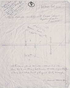
Map, Plan of Subdivision - Canterbury Park Estate, Ringwood East, Victoria - 1954
... Plan of Subdivision - Canterbury Park Estate, Ringwood East, Victoria - 1954 Map ...Hand drawn page with diagram of map and property title information - three residential allotments on Bedford Road and Bedford Court, Ringwood East.Vol 8069 Fol 204. Canterbury Park Estate T.M. Burke Pty Ltd. Purchase price lot 6 £525 Deposit £55. Monthly payments £11. Terms 7 years, Interest 4-1/2%. Frank Kolarch 124 Bedford Road Ringwood, Labourer, Registered proprietor 5th November 1954. Lot 6 Plan of Subdivision no. 23805. Part of CP18, Parish of Ringwood, County of Mornington. -
 Ringwood and District Historical Society
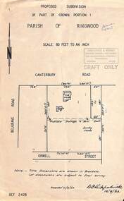
Map, Proposed Subdivision - Part of Crown Portion 1, Parish of Ringwood, Canterbury Road, east of Belgrave Road, Ringwood. 1963
... Proposed Subdivision - Part of Crown Portion 1, Parish of Ringwood, Canterbury Road, east of Belgrave Road, Ringwood. 1963. Map ...Diagram showing layout of property fronting Canterbury Road and backing onto Orwell Street, later Shortland Street, Ringwood. Rubber stamped Kirkpatrick & Webber, Surveyors, Engineers & Town Planners, 225 Maroondah Highway Ringwood, Telephone 870-0321. "Draft Only". Allotment 1 includes location of weatherboard house and sheds, and proposed drainage and sewerage easement. Note:- Title dimensions are shown in brackets. Lot dimensions are subject to final survey. Signed by D. Kirkpatrick, 16/8/1963. Amended 21/8/1963. -
 Ringwood and District Historical Society
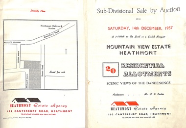
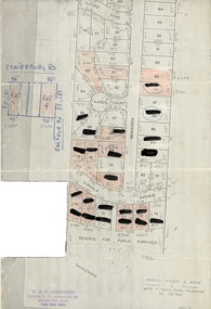
Flyer - Land Sales Brochure, Sub-Divisional Sale by Auction - Mountain View Estate, Heathmont, Victoria - 1957
... Agent - Heathmont Estate Agency, 103 Canterbury Road, Heathmont, Telephone WU6808, after hours WF1488. Auctioneer Mr. A.B. Carter. Accompanying Parish of Ringwood survey map with cardboard backing - Part of Crown Allotment 14B, includes handwritten price notations for each allotment....Agent - Heathmont Estate Agency, 103 Canterbury Road, Heathmont, Telephone WU6808, after hours WF1488. Auctioneer Mr. A.B. Carter. Accompanying Parish of Ringwood survey map with cardboard backing - Part of Crown Allotment 14B, includes handwritten price notations for each allotment. ...Bi-fold pamphlet advertising auction of 20 residential allotments on Saturday, 14th December, 1957, with description of services available and finance terms. Subdivision inclues Orchard Grove and Barnic Road. Agent - Heathmont Estate Agency, 103 Canterbury Road, Heathmont, Telephone WU6808, after hours WF1488. Auctioneer Mr. A.B. Carter. Accompanying Parish of Ringwood survey map with cardboard backing - Part of Crown Allotment 14B, includes handwritten price notations for each allotment. -
 Ringwood and District Historical Society
Document, Map showing numbered subdivision allotments with hand-written notations and redactions - 1924
... Map by Arnold Wilson & Associates, Engineers & Surveyors, 399 St.Kilda Road, Melbourne, Tel 26-1840 - 1924/4. Subdivision includes Ilford Road, Karen Court, Washusen Road and Dirkala Avenue, Heathmont. Also includes hand-drawn allotments on Canterbury...Ringwood and District Historical Society 125A Warrandyte Road Ringwood North melbourne Map by Arnold Wilson & Associates, Engineers & Surveyors, 399 St.Kilda Road, Melbourne, Tel 26-1840 - 1924/4. Subdivision includes Ilford Road, Karen Court, Washusen Road and Dirkala Avenue, Heathmont. Also includes hand-drawn allotments on Canterbury ...Foolscap size page Map by Arnold Wilson & Associates, Engineers & Surveyors, 399 St.Kilda Road, Melbourne, Tel 26-1840 - 1924/4. Subdivision includes Ilford Road, Karen Court, Washusen Road and Dirkala Avenue, Heathmont. Also includes hand-drawn allotments on Canterbury Road and Balfour Avenue. Page rubber-stamped by building company A & C Jaworski, Office 2, 23 Ringwood Street, Ringwood 3134, Tel 870-0820, A.H. 870-2062. -
 Ringwood and District Historical Society
Document - Map, Plan of Subdivision - Part of Crown Allotments 14A & 14C, Parish of Ringwood, County of Mornington, Vol 5378 Fol 511 - 1927
... Map includes Canterbury Road, Heathmont Road, Dickasons Road, Bennett Avenue, Orchid Street and Allens Road, Heathmont, Vic....Ringwood and District Historical Society 125A Warrandyte Road Ringwood North melbourne Map includes Canterbury Road, Heathmont Road, Dickasons Road, Bennett Avenue, Orchid Street and Allens Road, Heathmont, Vic. ...Department of Lands and Survey photocopy dated 17/1/1951, page number 12308.Map includes Canterbury Road, Heathmont Road, Dickasons Road, Bennett Avenue, Orchid Street and Allens Road, Heathmont, Vic. -
 Ringwood and District Historical Society
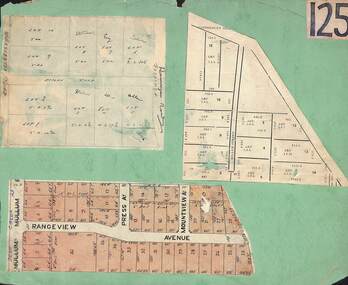
Card, Collage of Residential Subdivision Map Clippings - Ringwood, Victoria - (Undated)
... Map with acres roods and perches measurements of allotments in Canterbury Road and Miller Street Heathmont. ...Map with acres roods and perches measurements of allotments in Canterbury Road and Miller Street Heathmont. ...Three maps mounted on green cardboard - Hand-drawn map of residential allotments off Warrandyte Road in Milne Road and Berringa Road Park Orchards. Map with acres roods and perches measurements of allotments in Canterbury Road and Miller Street Heathmont. Clipping from a land sale brochure with street names not existing together in the area - Rangeview Avenue, Press Avenue and Mountview Avenue. -
 Ringwood and District Historical Society
Map - Plan of Subdivision, Part of Crown Portion 7, Parish of Ringwood, County of Mornington - circa 1950
... Hand-drawn map attached to light cardboard backing showing 5 residential allotments on eastern side of Maidstone Street Ringwood, north of Canterbury Road....Ringwood and District Historical Society 125A Warrandyte Road Ringwood North melbourne RFK 8/11/51 Hand-drawn map attached to light cardboard backing showing 5 residential allotments on eastern side of Maidstone Street Ringwood, north of Canterbury Road. ...Hand-drawn map attached to light cardboard backing showing 5 residential allotments on eastern side of Maidstone Street Ringwood, north of Canterbury Road.RFK 8/11/51 -
 Ringwood and District Historical Society
Map, Subdivision Plan of residential allotments on Canterbury Road, Bayswater (later surrounding Miller Road, Heathmont), Victoria - (Undated - circa 1930s)
... map on cardboard backing. Includes red pen notations marking allotments sold to Mrs A. Harrison, Mrs C Cornwall, J.M. Miller, and A.W. Dickson. Subdivision Plan of residential allotments on Canterbury ...Hand-drawn map on cardboard backing. Includes red pen notations marking allotments sold to Mrs A. Harrison, Mrs C Cornwall, J.M. Miller, and A.W. Dickson.Red pen notations mark allotments sold to Mrs A. Harrison, Mrs C Cornwall, J.M. Miller, and A.W. Dickson. Later subdivision of the map area took in Miller Road and Atunga Court developments.