Federation University Historical Collection
Map, Shire of Buninyong, c1970
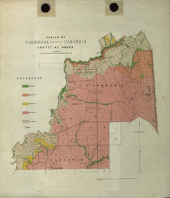
... ...cargerie...Barker Library (top floor) Mount Helen goldfields The Shire of Buninyong was located on the southern side of Ballarat. shire of buninyong buninyong clarendon narmbool enfield lychfield scotchman's navigators warrenheip scotsburn mt doran durham lead cambrian hill napoleons garibaldi mt clear lal lal bonshaw state forest elaine elaine north cargerie grenville mt mercer millbrook wallace yendon canadian kaolin deposits Mount Helen Campus .1) B.I.A.E., St Martin's, cemetery, mt Buninyong, mt Innes, rly stn Two maps of the Shire of Buninyong.
.1) Map showing the County divisions, township boundaries, Railway line, State Forest boundary, riding boundary and shire boundary. ...
The Shire of Buninyong was located on the southern side of Ballarat.Two maps of the Shire of Buninyong.
.1) Map showing the County divisions, township boundaries, Railway line, State Forest boundary, riding boundary and shire boundary. Identifying words have been added in red and green texta.
.2) Shire of Buninyong Parish Plan. Includes Buninyong, Clarendon, Narmbool, Enfield, Lychfield, SCotchman's, Navigators, Warrenheip, Scotsburn, mr Doran, Durham Lead, Cambrian Hill, Napoleons, Garibaldi, Mt Clear, Lal Lal, Bonshaw.1) B.I.A.E., St Martin's, cemetery, mt Buninyong, mt Innes, rly stn
shire of buninyong, buninyong, clarendon, narmbool, enfield, lychfield, scotchman's, navigators, warrenheip, scotsburn, mt doran, durham lead, cambrian hill, napoleons, garibaldi, mt clear, lal lal, bonshaw, state forest, elaine, elaine north, cargerie, grenville, mt mercer, millbrook, wallace, yendon, canadian, kaolin deposits, mount helen campus
 Federation University Historical Collection
 Clunes Museum
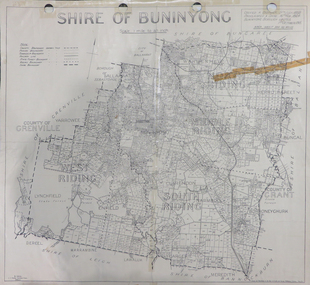 Federation University Historical Collection