Showing 12 items matching "carrum hotel"
-
 Chelsea & District Historical Society Inc
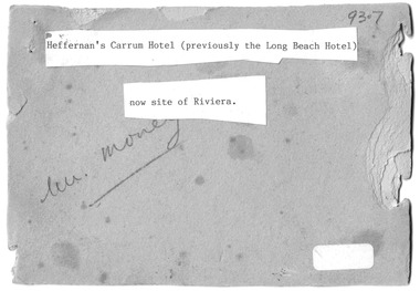
Photograph - Heffernan's Hotel, Carrum, c 1912
... Heffernan's Hotel, Carrum......Carrum Hotel...Thomas Heffernam (1860-1934) purchased the Carrum Hotel situated in Point Nepean Road (now 30 Nepean Highway Seaford). ...Black and white photo of a group of people standing in front of Carrum Hotel (Heffernan's), Carrum...Heffernan's Carrum Hotel; Afternoon Tea...The Riviera Hotel now occupies this site (2025). Carrum Seaford Carrum Hotel horse and cart Long Beach Hotel Riviera Hotel Heffernan Heffernan's Carrum Hotel; Afternoon Tea Black and white photo of a group of people standing in front of Carrum Hotel (Heffernan's), Carrum Photograph Heffernan's Hotel, Carrum ...Thomas Heffernam (1860-1934) purchased the Carrum Hotel situated in Point Nepean Road (now 30 Nepean Highway Seaford). The hotel was previously called Long Beach Hotel. The Riviera Hotel now occupies this site (2025).Black and white photo of a group of people standing in front of Carrum Hotel (Heffernan's), CarrumHeffernan's Carrum Hotel; Afternoon Teacarrum, seaford, carrum hotel, horse and cart, long beach hotel, riviera hotel, heffernan -
 Chelsea & District Historical Society Inc
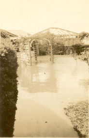
Photograph - Chelsea Flood December 1934, Carrum Hotel, Nepean Highway
... Carrum Hotel, Nepean Highway......Carrum Hotel...Black and white photo of flood waters in the garden of Carrum Hotel, showing an archway and in the background is a partially built building....Carrum Hotel, Nepean Highway Photograph Chelsea Flood December 1934 ...In December 1934, 700 houses were inundated with water, when the Dandenong Creek and Patterson River broke their banks.Black and white photo of flood waters in the garden of Carrum Hotel, showing an archway and in the background is a partially built building.flood, chelsea, dandenong creek, nepean highway, point nepean road, carrum hotel -
 City of Moorabbin Historical Society (Operating the Box Cottage Museum)
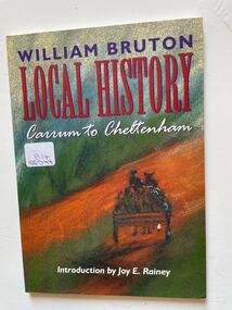
Book, E-Gee Printers Pty.Ltd, Local History : Carrum to Cheltenham, 1999
... carrum...mordialloc...picnic...asylum...hobsons bay...brighton...beach boxes...bridge hotel...The book is in a diary format with entries listed under headings in bold type.The entries give a very good outline of how people were living at the time so far away from the city of Melbourne. cheltenham kingston pioneers moorabbin carrum mordialloc picnic asylum hobsons bay brighton beach boxes bridge hotel. ...A small softcover book dark green in colour at the top of the front cover is the authors name written in purple and the book's title written in large red letters there is also a charcoal drawing of a person driving a horse and dray with what looks like sacks of produce in the back on the back cover is text by the author and three reviews by different people.The book also contains a lot of old black and white photos of the family and places of note in the area.cheltenham, kingston, pioneers, moorabbin, carrum, mordialloc, picnic, asylum, hobsons bay, brighton, beach boxes, bridge hotel. -
 Dandenong & District Historical Society
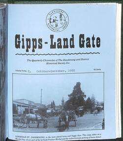
Journal, Dandenong & District Historical Society, Gipps-Land Gate Vol43 No1, 2016
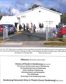
... Dandenong & District Historical Society 1st Floor, 39 Clow Street Dandenong melbourne Hotel history Early education in Dandenong Interesting Milestones Family Histories An interesting group of Early Dandenong Personalities, Places and Events A5 size publication of the Gipps-Land Gate, April, 2016 featuring an old picture of Dandenong on the cover. We Miss You Jan History Of Floods At Dandenong The Carrum ...An interesting group of Early Dandenong Personalities, Places and EventsA5 size publication of the Gipps-Land Gate, April, 2016 featuring an old picture of Dandenong on the cover. We Miss You Jan History Of Floods At Dandenong The Carrum Swamp South-West Of Dandenong The Dandenong Creek At Dandenong Other Flooding In Dandenong Retarding Basins And Flood Plains The 1934 Flood Drownings In The Dandenong Creek At Or Below Dandenong Dandenong Panoramic (Lunar Dandenong) Drive-In Theatre Harking Back 73 Years Official Launch Of CGD Archive Facility President's Report An interesting group of Early Dandenong Personalities, Places and Eventshotel history, early education in dandenong, interesting milestones, family histories -
 Dandenong & District Historical Society
Journal, Dandenong & District Historical Society, Gipps-Land Gate Vol.15 No.2, 1988
... Dandenong & District Historical Society 1st Floor, 39 Clow Street Dandenong melbourne Hotel history Early education in Dandenong Interesting Milestones Family Histories An interesting group of Early Dandenong Personalities, Places and Events A5 size publication of the Gipps-Land Gate, October-December, 1988 featuring an old picture of Dandenong on the cover. Keeping Posted A "Deners" Boy Recalls A War-Time Blunder Remember? 25 Years Ago Personalities Behind The Headstones Harking Back 75 Years Ago The Dunbars Of Dandenong The Challenge Of The Carrum ...An interesting group of Early Dandenong Personalities, Places and EventsA5 size publication of the Gipps-Land Gate, October-December, 1988 featuring an old picture of Dandenong on the cover. Keeping Posted A "Deners" Boy Recalls A War-Time Blunder Remember? 25 Years Ago Personalities Behind The Headstones Harking Back 75 Years Ago The Dunbars Of Dandenong The Challenge Of The Carrum Carrum Swamp Verdict A Nice Christmas Present An interesting group of Early Dandenong Personalities, Places and Eventshotel history, early education in dandenong, interesting milestones, family histories -
 Chelsea & District Historical Society Inc
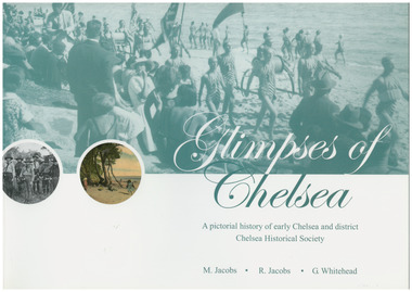
Book, G.Whitehead, Glimpses of Chelsea, 2007
... hotels, railways, industry, hospitals and halls, and many other pictures of local scenes. A unique history of the District of Chelsea. Photographs show the beginnings and how the Chelsea district was developed. Various Sporting clubs and groups, businesses, buildings, streets and early European settlers and others. Aspendale Carrum ...Photos and descriptions of historical buildings Chelsea District Historical Society is fortunate to have many photos that have been donated and collated over the last fifty years. In the early years our beachside suburb was popular with groups and families. Camping & holidaying in guest houses or privately rented houses. This book includes photographs of local people, beaches, churches, clubs, sports, hotels, railways, industry, hospitals and halls, and many other pictures of local scenes. A unique history of the District of Chelsea. Photographs show the beginnings and how the Chelsea district was developed. Various Sporting clubs and groups, businesses, buildings, streets and early European settlers and others. Large soft cover book A pictorial history of early Chelsea & District first printed 2007aspendale, carrum, bonbeach, edithvale, chelsea -
 City of Kingston
Photograph - Colour, 1998
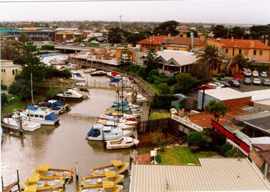
... Carrum Swamp which was abundant with wild life and natural resources. Regular encroachments, including land sales which began in 1863, were made on the land until 1878 when the Reserve was declared closed, and the land was opened up to land sales. Market gardening and suburban house lots quickly began to develop, and Mordialloc became a renowned picnic and holiday site. Mordialloc Creek is a popular bay side destination for local and visitors, and is a site for boating, kayaking, fishing and swimming, along with many other activities. Mordialloc Bunurong Traditional Owners Suburbs Boats Fishing Waterways Hotel ...The name Mordialloc was derived from the name Moody Yallock, which comes from the Bunurong language. The Bunurong Peoples are the Traditional Owners of this area. The name means “high water” or “high creek”. In 1839, colonial authorities declared the mouth of the creek, and an additional 830 odd acres as an Aboriginal Reserve, although this proclamation was never gazetted. The reserved land included part of the Carrum Carrum Swamp which was abundant with wild life and natural resources. Regular encroachments, including land sales which began in 1863, were made on the land until 1878 when the Reserve was declared closed, and the land was opened up to land sales. Market gardening and suburban house lots quickly began to develop, and Mordialloc became a renowned picnic and holiday site. Mordialloc Creek is a popular bay side destination for local and visitors, and is a site for boating, kayaking, fishing and swimming, along with many other activities.Colour photograph of Mordialloc Creek, looking inland.Small fishing and leisure boats are moored on either side of creek, with a view of the Mordialloc Bridge Hotel in the background.mordialloc, bunurong, traditional owners, suburbs, boats, fishing, waterways, hotel -
 City of Kingston
Photograph - Colour, Paul Tresize, 1998
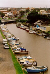
... Carrum Swamp which was abundant with wild life and natural resources. Regular encroachments, including land sales which began in 1863, were made on the land until 1878 when the Reserve was declared closed, and the land was opened up to land sales. Market gardening and suburban house lots quickly began to develop, and Mordialloc became a renowned picnic and holiday site. Mordialloc Creek is a popular bay side destination for local and visitors, and is a site for boating, kayaking, fishing and swimming, along with many other activities. Mordialloc Bunurong Traditional Owners Suburbs Boats Fishing Waterways Hotel ...The name Mordialloc was derived from the name Moody Yallock, which comes from the Bunurong language. The Bunurong Peoples are the Traditional Owners of this area. The name means “high water” or “high creek”. In 1839, colonial authorities declared the mouth of the creek, and an additional 830 odd acres as an Aboriginal Reserve, although this proclamation was never gazetted. The reserved land included part of the Carrum Carrum Swamp which was abundant with wild life and natural resources. Regular encroachments, including land sales which began in 1863, were made on the land until 1878 when the Reserve was declared closed, and the land was opened up to land sales. Market gardening and suburban house lots quickly began to develop, and Mordialloc became a renowned picnic and holiday site. Mordialloc Creek is a popular bay side destination for local and visitors, and is a site for boating, kayaking, fishing and swimming, along with many other activities.Colour photograph of Mordialloc Creek, looking inland. Boats are moored on either side of the creek and the Bridge Hotel is visible in the background.mordialloc, bunurong, traditional owners, suburbs, boats, fishing, waterways, hotel -
 City of Kingston
Photograph - Colour, Paul Tresize, 1998
... Carrum Swamp which was abundant with wild life and natural resources. Regular encroachments, including land sales which began in 1863, were made on the land until 1878 when the Reserve was declared closed, and the land was opened up to land sales. Market gardening and suburban house lots quickly began to develop, and Mordialloc became a renowned picnic and holiday site. Mordialloc Creek is a popular bay side destination for local and visitors, and is a site for boating, kayaking, fishing and swimming, along with many other activities. Mordialloc Bunurong Traditional Owners Suburbs Boats Fishing Waterways Hotel ...The name Mordialloc was derived from the name Moody Yallock, which comes from the Bunurong language. The Bunurong Peoples are the Traditional Owners of this area. The name means “high water” or “high creek”. In 1839, colonial authorities declared the mouth of the creek, and an additional 830 odd acres as an Aboriginal Reserve, although this proclamation was never gazetted. The reserved land included part of the Carrum Carrum Swamp which was abundant with wild life and natural resources. Regular encroachments, including land sales which began in 1863, were made on the land until 1878 when the Reserve was declared closed, and the land was opened up to land sales. Market gardening and suburban house lots quickly began to develop, and Mordialloc became a renowned picnic and holiday site. Mordialloc Creek is a popular bay side destination for local and visitors, and is a site for boating, kayaking, fishing and swimming, along with many other activities.Colour photograph of Mordialloc Creek with boats moored on both sides of the street and Pompei's boat yard visible on the right hand side of the creek., Main Street and St Brigid's Catholic Church are visible in backgroundmordialloc, bunurong, traditional owners, suburbs, boats, fishing, waterways, hotel, church -
City of Kingston
Photograph - Colour, 31 January 1993
... Development has been continuous since the 1970s with construction of residential housing, schools, shopping centres, marinas, a hotel and library. Patterson Lakes Seaford Kananook Creek Carrum Carrum Swamp Canals and waterways Black typed lettering on white adhesive label: 31.1.93 Black typed lettering on white adhesive label: 27E/7140 31/1/93 12.55 pm Black typed lettering on white label: 7140 Yellow round adhesive label located on left side Laminated colour aerial photograph of the Carrum and Patterson Lakes region within City of Kingston. ...Patterson Lakes is a suburb in the City of Kingston that is built one kilometre upstream of the mouth of the Patterson River. The area is bordered by the Patterson River and Eel Race Drain which enters the Kananook Creek. The suburb consists predominantly of newer housing developments and the tidal canal system of the development joins Port Phillip Bay. Patterson Lakes and the Kananook Creek were previously part of the extensive Carrum Carrum Swamp. The area was once a source of fish and eels for the Mayone-Bulluk clan of the Bunurong people. Over time the area was drained and in 1973 investigations commenced into the development of a unique residential area that would be built adjacent to canals and waterways. It was originally proposed to be known as "Gladesville". The development would give the suburb's homeowners access to Port Phillip Bay "from their back door". Circa 1974, the area was rezoned from rural to residential and named Patterson Lakes. Development has been continuous since the 1970s with construction of residential housing, schools, shopping centres, marinas, a hotel and library.Laminated colour aerial photograph of the Carrum and Patterson Lakes region within City of Kingston. This 1993 image includes Patterson River Secondary College, Roy Dore Reserve, Kananook Creek and Nepean Highway. The railway line can be seen as it veers inland from Eel Race Road, Seaford. The section of Ocean Reef Drive and Palm Beach Drive in Patterson Lakes appears to be a recent development with many spare blocks and new houses under construction.Black typed lettering on white adhesive label: 31.1.93 Black typed lettering on white adhesive label: 27E/7140 31/1/93 12.55 pm Black typed lettering on white label: 7140 Yellow round adhesive label located on left sidepatterson lakes, seaford, kananook creek, carrum carrum swamp, canals and waterways -
City of Kingston
Photograph - Colour, c. 1993
... Development has been continuous since the 1970s with construction of residential housing, schools, shopping centres, marinas, a hotel and library. Patterson Lakes Seaford Kananook Creek Carrum Carrum Swamp Canals and waterways Laminated colour aerial photograph of the Carrum and Patterson Lakes region within City of Kingston. ...Patterson Lakes is a suburb in the City of Kingston that is built one kilometre upstream of the mouth of the Patterson River. The area is bordered by the Patterson River and Eel Race Drain which enters the Kananook Creek. The suburb consists predominantly of newer housing developments and the tidal canal system of the development joins Port Phillip Bay.Patterson Lakes and the Kananook Creek were previously part of the extensive Carrum Carrum Swamp. The area was once a source of fish and eels for the Mayone-Bulluk clan of the Bunurong people. Over time the area was drained and in 1973 investigations commenced into the development of a unique residential area that would be built adjacent to canals and waterways. It was originally proposed to be known as "Gladesville". The development would give the suburb's homeowners access to Port Phillip Bay "from their back door". Circa 1974, the area was rezoned from rural to residential and named Patterson Lakes. Development has been continuous since the 1970s with construction of residential housing, schools, shopping centres, marinas, a hotel and library.Laminated colour aerial photograph of the Carrum and Patterson Lakes region within City of Kingston. This 1993 image includes Patterson River Secondary College, Roy Dore Reserve, Kananook Creek and Nepean Highway. The railway line can be seen as it veers inland from Eel Race Road, Seaford. The section of Palm Beach Drive, Curlew Point Drive, Snapper Point Drive, Clipper Island and Myola Street in Patterson Lakes appears to be a recent development with many spare blocks and new houses under construction.patterson lakes, seaford, kananook creek, carrum carrum swamp, canals and waterways -
City of Kingston
Photograph - Colour, 1993
... Carrum Swamp. The district had originally been the home of the Bunerong people who fished, gathered food and found refuge in the sand dunes. The Swamp was drained in 1879 when the Patterson Cut was formed and became known as Patterson River. Apart from local farmers, fishermen and hotel ...Carrum is a suburb in the City of Kingston bordered by the Patterson River in the north and Kananook Creek in the south. To the east the suburb is adjacent to Patterson Lakes. The Carrum Station was opened in 1882, when the railway line from Mordialloc was extended to Frankston. In the early 20th century, it was a destination for holidaymakers occupying tents and cabins. The area now consists of older housing and over time there have been many new housing developments.Carrum is located in the area that was originally part of the Carrum Carrum Swamp. The district had originally been the home of the Bunerong people who fished, gathered food and found refuge in the sand dunes. The Swamp was drained in 1879 when the Patterson Cut was formed and became known as Patterson River. Apart from local farmers, fishermen and hotel-keepers, there were few permanent residents until the early 20th century when it had become popular as a beach resort. In the 1920s and 1930s the area became occupied by more permanent residents.Laminated aerial colour photograph of Carrum and Patterson Lakes in the City of Kingston. The photograph also includes Kananook Creek and the northern section of Seaford. Prominent features include Roy Dore Reserve, Carrum Primary School, Patterson River Secondary College, Keast Park Seaford, the Seaford Swamp Drain and a section of Downs Estate situated on the traditional lands of the Bunurong people.Black type on white adhesive sticker: No. 7140 Black type of white adhesive sticker: 31-1-93 Black handwritten ink (marker): * [an asterisk] Yellow circular adhesive stickerpatterson lakes, seaford, carrum carrum swamp