Showing 13 items matching "celestial navigation"
-
 Moorabbin Air Museum
Manual (Item) - AF 51-40 Vol 2 Air Navigation Celestial and Polar Navigation
... AF 51-40 Vol 2 Air Navigation Celestial and Polar Navigation...Moorabbin Air Museum Moorabbin Airport 12 First Street Moorabbin melbourne Manual AF 51-40 Vol 2 Air Navigation Celestial and Polar Navigation ... -
Moorabbin Air Museum
Manual (Item) - AF 51-40 Vol 2 Air Navigation Celestial and Polar Navigation
... AF 51-40 Vol 2 Air Navigation Celestial and Polar Navigation...Moorabbin Air Museum Moorabbin Airport 12 First Street Moorabbin melbourne Manual AF 51-40 Vol 2 Air Navigation Celestial and Polar Navigation ... -
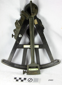
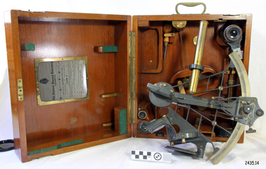 Flagstaff Hill Maritime Museum and Village
Instrument - Navigational Sextant, 1882-1890
... ...celestial navigation...The primary use was to measure the angle between an astronomical object and the horizon for the purposes of celestial navigation. The estimation of this angle is known as sighting or shooting the object, or taking a sight. ...The primary use was to measure the angle between an astronomical object and the horizon for the purposes of celestial navigation. The estimation of this angle is known as sighting or shooting the object, or taking a sight. ...A sextant is an astronomical instrument used to determine latitude and longitude at sea by measuring angular distances, especially the altitudes of the sun, moon, and stars. It is a doubly reflecting navigation instrument and used mainly by sailors to measure the angular distance between two visible objects. The name comes from the Latin sextans, or “sixth part of a unit,” because the sextant’s arc can be 60° or 120° of a circle depending on the model used. The primary use was to measure the angle between an astronomical object and the horizon for the purposes of celestial navigation. The estimation of this angle is known as sighting or shooting the object, or taking a sight. This angle and the time when it was measured is used in order to determine Greenwich Mean Time and hence longitude. Sighting the height of a landmark on land can also give a measure of distance from that object. History: The development of the sextant was as an improvement over the octant, an instrument designed to measure one's latitude. The octant was first implemented around 1731-present but can only measure angles up to 45°. As larger angles were needed to allow the measurement of lunar objects - moon, stars and the sun - at higher angles, the octant was superseded by the sextant. The sextant is a similar instrument but better made and allows larger angles from 60° to 120°. This improvement allows distances to be accurately calculated thereby giving longitude when used with a chronometer. The sextant was derived from the octant in 1757, eventually making all previous instruments used for navigational positioning obsolete. The sextant had been attributed to by John Hadley (1682–1744) and Thomas Godfrey (1704–1749), but reference to the sextant was also found later in the unpublished writings of Isaac Newton (1643–1727). Earlier links can be found to Bartholomew Gosnold (1571–1607) indicating that the use of a sextant for nautical navigation predates Hadley's implementation. In 1922, the sextant was modified for aeronautical navigation by Portuguese navigator and naval officer Gago Coutinho. It should be noted that the octant and quadrant are in the same family as they were, and all are, regarded as sextants. The sextant is representative of it's type and although not fully complete it demonstrates how 18th,19th and 20th century mariners determined their latitude and longitudinal to determine their position on a chart, allowing them to navigate there way across the world's oceans. It also demonstrates the skill and workmanship of the early instrument makers that operated scientific instrument businesses from London and other areas of England to provide most of the navigational instrumentation used by commercial and military navies of the time.Sextant with square, fitted box of polished wood, "Hezzanith" brand. Box contains many parts for the sextants use. On certificate "Heath & Co, London. Sextant Number Y 822". Catch on lid "DEFIANT LEVER" and "PATENT NUMBER 187.10". Maker's certificate is attached to the inside of the box.flagstaff hill, warrnambool, shipwrecked-coast, flagstaff-hill, flagstaff-hill-maritime-museum, maritime-museum, shipwreck-coast, flagstaff-hill-maritime-village, sextant box, sextant, hezzanith, heath & co, navigational instrument, george wilson heath, astronomical instrument, instrument manufacturers, scientific instrument, navigation, celestial navigation, octant, quadrant, lunar navigation -
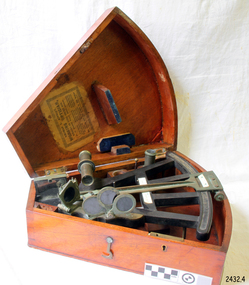
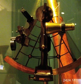 Flagstaff Hill Maritime Museum and Village
Instrument - Sextant, Late 20th Century
... The primary use of a sextant is to measure the angle between an astronomical object and the horizon for the purposes of celestial navigation....The primary use of a sextant is to measure the angle between an astronomical object and the horizon for the purposes of celestial navigation. Instrument Sextant Kelvin & Hughes ...In 1941, the scientific instrument manufacturing firms of Henry Hughes & Son Ltd, London, England, and Kelvin Bottomley & Baird Ltd, Glasgow, Scotland, came together to form Kelvin & Hughes Ltd. Kelvin Company History: The origins of the company lie in the highly successful and strictly informal relationship between William Thomson (1824-1907), Professor of Natural Philosophy at Glasgow University from 1846-1899 and James White, a Glasgow optical maker. James White (1824-1884) founded the firm of James White, an optical instrument maker in Glasgow in 1850 and was involved in supplying and mending apparatus for Thomson university laboratory and working with him on experimental constructions. White was declared bankrupt in August 1861 and released several months later. In 1870, White was largely responsible for equipping William Thomson laboratory in the new University premises at Gilmore hill. From 1876, he was producing accurate compasses for metal ships to Thomson design during this period and this became an important part of his business in the last years of his life. He was also involved in the production of sophisticated-sounding machinery that Thomson had designed to address problems encountered laying cables at sea, helping to make possible the first transatlantic cable connection. At the same time, he continued to make a whole range of more conventional instruments such as telescopes, microscopes and surveying equipment. White's association with Thomson continued until he died. After his death, his business continued under the same name, being administered by Matthew Edwards (until 1891 when he left to set up his own company. Thomson who became Sir William Thomson and then Baron Kelvin of Largs in 1892, continued to maintain his interest in the business after James White's death. In 1884 raising most of the capital needed to construct and equip new workshops in Cambridge Street, Glasgow. At these premises, the company continued to make the compass Thomson had designed during the 1870s and to supply it in some quantity, especially to the Admiralty. At the same time, the firm became increasingly involved in the design, production and sale of electrical apparatus. In 1899, Lord Kelvin resigned from his University chair and became, in 1900, a director in the newly formed limited liability company Kelvin & James White Ltd which had acquired the business of James White. At the same time Kelvin's nephew, James Thomson Bottomley (1845-1926), joined the firm. In 1904, a London branch office was opened which by 1915 had become known as Kelvin, White & Hutton Ltd. Kelvin & James White Ltd underwent a further change of name in 1913, becoming Kelvin Bottomley & Baird Ltd. Hughes Company History: Henry Hughes & Sons were founded in 1838 in London as a maker of chronographic and scientific instruments. The firm was incorporated as “Henry Hughes & Sons Ltd” in 1903. In 1923, the company produced its first recording echo sounder and in 1935 a controlling interest in the company was acquired by S Smith & Son Ltd resulting in the development and production of marine and aircraft instruments. Following the London office's destruction in the Blitz of 1941, a collaboration was entered into with Kelvin, Bottomley & Baird Ltd resulting in the establishing “Marine Instruments Ltd”. Following the formal amalgamation of Kelvin, Bottomley & Baird Ltd and Henry Hughes & Sons Ltd in 1947 to form Kelvin & Hughes Ltd. Marine Instruments Ltd then acted as regional agents in the UK for Kelvin & Hughes Ltd who were essentially now a part of Smith's Industries Ltd founded in 1944 and the successors of S. Smith & Son Ltd. Kelvin & Hughes Ltd went on to develop various marine radar and echo sounders supplying the Ministry of Transport, and later the Ministry of Defence. The firm was liquidated in 1966 but the name was continued as Kelvin Hughes, a division of the Smiths Group. In 2002, Kelvin Hughes continues to produce and develop marine instruments for commercial and military. G. Falconer Company History: G Falconer (Hong Kong Ltd) appear to have had a retail presence in Hong Kong since 1885, according to the company website, and currently have a shop in the Peninsula Hotel. G Falconer was the Hong Kong selling agent for several British companies. Ross Ltd of 111 New Bond St London was one and the other was Kelvins Nautical Instruments. Falconers were primarily watchmakers, jewellers and diamond merchants.They were also agents for Admiralty Charts, Ross binoculars and telescopes, and sold English Silverware and High Class English Jewellery. In 1928 the company was operating from the Union Building opposite the Hong Kong general post office. It is unclear if the item is an original Sextant made by Kelvin prior to his amalgamation with Henry Hughes & Sons in 1941 as Kelvin appears to have only made compasses up to this date. If the Sextant can be established that it was made by Kelvin then it is very significant and a rare item made for and distributed through their Hong Kong selling agents G Falconer Ltd. There are many Sextants advertised for sale stating "Kelvin & Hughes 1917 model sextant". These can be regarded as replicas as the company was not formed until 1941 and production of marine instruments was not fully under way until after the war in 1947. Further investigation needs to be undertaken to accurately determine the provenance of this item. As the writer currently has the impression that the subject object was possibly made by Kelvin and Hughes in the mid to late 20th century or is a replica made by an unknown maker in the late 1970s. Purchased as an exhibition of marine navigational instruments for the Flagstaff Hill museum. The Sextant is a brass apparatus with filters and telescope lens, and comes with a wooden felt lined storage box. It is a doubly reflecting navigation instrument that measures the angular distance between two visible objects. The primary use of a sextant is to measure the angle between an astronomical object and the horizon for the purposes of celestial navigation.G Falconer and Co. Hong Kong (retailers of nautical equipmentflagstaff hill, warrnambool, shipwrecked-coast, flagstaff-hill, flagstaff-hill-maritime-museum, maritime-museum, shipwreck-coast, flagstaff-hill-maritime-village, sextant, kelvin & hughes ltd, hong kong, navigational instrument, g falconer, mariner's quadrants -
 Sunshine and District Historical Society Incorporated
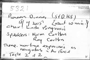
Audio - Sunshine And District Historical Society Pioneers Dinner 2005 Audio Tape 2, Sunshine and District Historical Society Inc, 2005
... Guest speakers Norm Carlton and Ray Carlton 'Wartime experiences as navigators in the Air Force' During WW11 Air Force navigators used a combination of dead reckoning, celestial navigation and radio navigation to guide aircraft. ...Guest speakers Norm Carlton and Ray Carlton 'Wartime experiences as navigators in the Air Force' During WW11 Air Force navigators used a combination of dead reckoning, celestial navigation and radio navigation to guide aircraft. ...The Sunshine and District Historical Society Pioneers’ Lunch / Dinner is an annual event. It’s a commemorative gathering that honours the early settlers, people, community leaders of Sunshine and the surrounding district, events, achievements, etc. At the Pioneers’ Lunch / Dinner, a toast is a ritual and a dedicated moment to honour the original settlers and their contributions, and a guest speaker talks about an interesting subject. Guest speakers Norm Carlton and Ray Carlton 'Wartime experiences as navigators in the Air Force' During WW11 Air Force navigators used a combination of dead reckoning, celestial navigation and radio navigation to guide aircraft. Navigators underwent intensive training to build their skills and adapt to changing conditions including night and bad weather flights.ray carlton, norm carlton, world war 1939 - 1945 -
 Sunshine and District Historical Society Incorporated
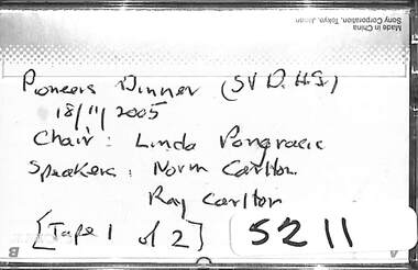
Audio - Sunshine And District Historical Society Pioneers Dinner 2005 Audio Tape 1
... Guest speakers Norm Carlton and Ray Carlton 'Wartime experiences as navigators in the Air Force' During WW11 Air Force navigators used a combination of dead reckoning, celestial navigation and radio navigation to guide aircraft. ...Guest speakers Norm Carlton and Ray Carlton 'Wartime experiences as navigators in the Air Force' During WW11 Air Force navigators used a combination of dead reckoning, celestial navigation and radio navigation to guide aircraft. ...The Sunshine and District Historical Society Pioneers’ Lunch / Dinner is an annual event. It’s a commemorative gathering that honours the early settlers, people, community leaders of Sunshine and the surrounding district, events, achievements, etc. At the Pioneers’ Lunch / Dinner, a toast is a ritual and a dedicated moment to honour the original settlers and their contributions, and a guest speaker talks about an interesting subject. Guest speakers Norm Carlton and Ray Carlton 'Wartime experiences as navigators in the Air Force' During WW11 Air Force navigators used a combination of dead reckoning, celestial navigation and radio navigation to guide aircraft. Navigators underwent intensive training to build their skills and adapt to changing conditions including night and bad weather flights.Pioneers Dinner (S&DHS) Chair Linda Pongracic Speakers Norm Carlton & Ray Carltonair force navigators, norm carlton, ray carlton, pioneers dinner, world war 1939 - 1945 -
B-24 Liberator Memorial Restoration Australia Inc
Bubble sextant, Henry Hughes & Son, c.1930s
... These instruments were used on aircraft to obtain the altitude of the sun or other celestial body to aid navigation. This particular one came from a former RAAF pilot....B-24 Liberator Memorial Restoration Australia Inc Corner Farm Rd & Princes Highway Werribee melbourne These instruments were used on aircraft to obtain the altitude of the sun or other celestial body to aid navigation. This particular one came from a former RAAF pilot. sextant, altitude, navigation, instrument This bubble sextant, complete with original wooden storage case with leather strap, was manufactured c.1930s. ...These instruments were used on aircraft to obtain the altitude of the sun or other celestial body to aid navigation. This particular one came from a former RAAF pilot.This bubble sextant, complete with original wooden storage case with leather strap, was manufactured c.1930s. Black and metallic, it has a mirror in the middle, various knobs on the sides and a cylindrical handle on each side.sextant, altitude, navigation, instrument -
 Flagstaff Hill Maritime Museum and Village
Octant, Late 18th to mid-19th century
... The primary use of an Octant is to measure the angle between an astronomical object and the horizon for the purposes of celestial navigation. The estimation of this angle is known as sighting or shooting the object, or taking a sight. ...The primary use of an Octant is to measure the angle between an astronomical object and the horizon for the purposes of celestial navigation. The estimation of this angle is known as sighting or shooting the object, or taking a sight. ...An Octant is a doubly reflecting navigation instrument used primarily by sailors to measure the angular distance between two visible objects and was a forerunner of the sextant. The name comes from the Latin octo, or “one-eighth of a circle,” for the Octant’s arc which spans 45°, or one-eighth of a circle. The primary use of an Octant is to measure the angle between an astronomical object and the horizon for the purposes of celestial navigation. The estimation of this angle is known as sighting or shooting the object, or taking a sight. The angle, and the time when it was measured, can be used to calculate a position line on a nautical chart (latitude), for example, sighting the Sun at noon or Polaris at night (in the Northern Hemisphere) gives an angle by which the latitude can then be estimated. Sighting the height of a landmark on land can also give a measure of distance. History: The principle of the Octant as an instrument to measure ones latitude was first implemented around 1742-present but was superseded by the improvement of the octant to a sextant, a very similar instrument, better made and able to measure bigger angles 120°, allowing the measurement of Luna distances to give longitude when used with an accurate chronometer. The sextant started to appear around 1730 and had been attributed to by John Hadley (1682–1744) and Thomas Godfrey (1704–1749), but reference to the sextant was also found later in the unpublished writings of Isaac Newton (1643–1727). Earlier links can be found to Bartholomew Gosnold (1571–1607) indicating that the use of a Sextant for nautical navigation predates Hadley's implementation. In 1922, the sextant was modified for aeronautical navigation by Portuguese navigator and naval officer Gago Coutinho. Henry Hemsley was a lesser-known instrument maker and optician working in London in the late 17th and early 18th century. However, it should be noted that there were two Henry Hemsley opticians and instrument makers around this period. (Henry Hemsley 1, 1786-89, who had premises at 85 Fleet St London and Henry Hemsley 2, 1828-56), whose workshop was at 135-138 Radcliff Highway London. Therefore, based on the inscribed workshop address Henry Hemsley 2 is responsible for making this example.The octant is representative of its type and although not fully complete it demonstrates how 18th and 19th-century mariners determined their latitude on a chart to navigate their way across the world's oceans in the 18th and 19th century. It also demonstrates the skill and workmanship of the early instrument makers that operated from London at this time and provided most of the navigational instrumentation use by commercial and military navies of the time.Octant, ebony wooden frame and handle. Scale is missing from recess in frame. "H. Hemsley 135-138 Ratliff Highway, London", no box"H. Hemsley 135-138 Ratcliff Highway, London"flagstaff hill, warrnambool, shipwrecked-coast, flagstaff-hill, flagstaff-hill-maritime-museum, maritime-museum, shipwreck-coast, flagstaff-hill-maritime-village, navigation, navigational instrument, instrument used for navigation, sextant, henry hemsley, instrument maker, london, octant -
 Flagstaff Hill Maritime Museum and Village
Instrument - Octant, mid 1800's
... The primary use of an Octant is to measure the angle between an astronomical object and the horizon for celestial navigation. The estimation of this angle, is known as sighting or shooting the object, or taking a sight. ...The primary use of an Octant is to measure the angle between an astronomical object and the horizon for celestial navigation. The estimation of this angle, is known as sighting or shooting the object, or taking a sight. ...An Octant is a doubly reflecting navigation instrument used primarily by sailors to measure the angular distance between two visible objects and was a forerunner of the sextant. The name comes from the Latin octo, or "one-eighth of a circle," for the Octan'ts arc which spans 45°, or one-eighth of a circle. The primary use of an Octant is to measure the angle between an astronomical object and the horizon for celestial navigation. The estimation of this angle, is known as sighting or shooting the object, or taking a sight. The angle, and the time when it was measured, can be used to calculate a position line on a nautical chart (latitude), for example, sighting the Sun at noon or Polaris at night (in the Northern Hemisphere) gives an angle by which the latitude can then be estimated. Sighting the height of a landmark on land can also give a measure of distance. This fine octant once belonged to Captain Farquhar Chisholm and was donated by his granddaughter, Margaret Ruth Greer (nee Chisholm, born 1914). The label inside the Octant's box reads “Thomas L. Ainsley, Instrument Maker … etc”. Farquhar Chisholm was born in 1832 in Inverness, Scotland. He regularly sailed on perilous voyages between Quebec, Canada and the Baltic ports of Europe. In 1854 he migrated to Australia during the Gold Rush, to a place called Fiery Creek (near Beaufort Victoria) where he was fairly successful in his quest for gold. In the years of the Great Gold Rush, it was said that there were over 40,000 diggers in the goldfields of the Beaufort area! In 1857 having made sufficient money, he hired another crew and returned to Clachnacuddin, Inverness shire, Scotland and in that same year, he studied and obtained his Master Mariner Certificate (which would have included the use of an octant for navigation). He was appointed to Mr George (or James) Walker, as commander of his sailing ship, the 3-masted ELIZABETH, built 1859 and known as “The Walker barque”. In 1870 he married, then in 1887 returned to Australia with his wife and children (Kenneth Chisholm (1871), Mary Bremner Chisholm (1873), Margaret Hood Chisholm (1874), Farquhar Chisholm (1878)). They arrived in Port Melbourne, Victoria and sadly, only six weeks after landing, his wife Caroline passed away (in Geelong,1888). In 1900 Capt. Chisholm lived in Camperdown (Victoria) and not long after this his daughter Margaret died of consumption. In his later years, he went to live in the manse of St. Paul’s Presbyterian Church, Wangaratta, with his son, Rev. Farquhar Chisholm. He died there on Sat, 23rd March 1912, 80 years old. He was known as “… quiet, unobtrusive and competent, respected by all with whom he came in contact”. Some other members of Captain Chisholm’s family are; his older son Kenneth Chisholm, who was a contractor in Camperdown; a nephew Donald Macintosh (of 23 Douglas Row, Inverness); a grandson Brian Jones (son of Caroline Belle-Jones nee Chisholm, who lived in Camperdown in the earlier part of her life).The octant, the forerunner of the sextant, was a significant step in providing accuracy of a sailors latitude position at sea & his vessels distance from land when taking sightings of land-based landmarks.Octant, once belonging to Captain Farquhar Chisholm. Wedge shape (the size of an eighth of a circle), made of wood, glass and metal. Used in the 1880s. Maker’s name across centre “L. SIMON - - - SHIELDS”. Three (3) light filtering, coloured glass shades. Two (2) eyepieces. Scale attached for measuring angles. Label inside the fitted, wedge-shaped case "Thomas L. Ainsley, Optician"Label inside case "Thomas L. Ainsley, Optician" Maker’s name across centre “L. SIMON - - - SHIELDS”.flagstaff hill, warrnambool, shipwrecked-coast, flagstaff-hill, flagstaff-hill-maritime-museum, maritime-museum, shipwreck-coast, flagstaff-hill-maritime-village, maritime navigation, navigation instrument, migration, captain chisholm, farquhar chisholm, sailing ship, the elizabeths, thomas l. ainsley, l. simons, shields england, octant, john hadley, chisholm -
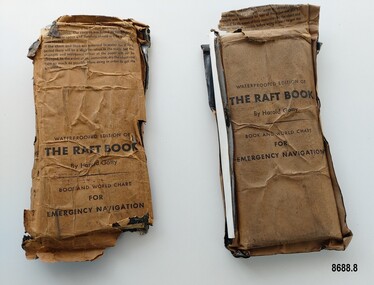 Flagstaff Hill Maritime Museum and Village
Booklet - Book and World Chart for Emergency Navigation, George Grady Press, The Raft Book, 1943
... W. 1 he joined the Australian Merchant Navy where he learned the constellations while standing night watch and became an expert in celestial navigation while serving on many ships sailing between Australia and California. ...W. 1 he joined the Australian Merchant Navy where he learned the constellations while standing night watch and became an expert in celestial navigation while serving on many ships sailing between Australia and California. ...Harold Gatty was born on January 5th, 1903 in Campbell Town, Tasmania. He was a navigator and aviation pioneer. He began his career learning navigation at the age of 14 as a midshipman at the Royal Australian Naval College but withdrew after three years and became an apprenticed ship's officer with the Patrick Steamship Company of Sydney. After W. W. 1 he joined the Australian Merchant Navy where he learned the constellations while standing night watch and became an expert in celestial navigation while serving on many ships sailing between Australia and California. In 1927 he moved to California and opened a navigation school and also a laboratory repairing navigational equipment. At this time he became very interested in air navigation and was aware of the limitations of existing methods and instruments for aerial navigation. He began researching ways of improving aerial navigation. Two early inventions of his were his air sextant and a ground speed and drift indicator which formed the basis of the automatic pilot which later came to be standard equipment on most aircraft. He worked with several record breaking pilots including Ann Morrow Lindbergh (who went on to serve as a navigator for her husband Charles Lindbergh), helped Wiley Post break the world record circumnavigating the Earth, invented a new method of "dead reckoning" that revolutionised the ability to fly safely through cloudy conditions without drifting off course and famously navigated a small plane (whilst trying to cross the Pacific) over 1900 km through fog (with no radio) and using only his dead reckoning techniques, back to their starting point in Japan after they developed fuel problems. In 1932 Gatty received the Distinguished Flying Cross from President Hoover. In 1934 Gatty formed the South Seas Commercial Company with Donald Douglas with the aim to deliver air services to the islands of the South Pacific. The Company was sold to Pan Am but he continued to work for them. In 1935 he went on a sailing expedition investigating several small islands in the South Pacific and was briefly marooned on Baker Island. He was able to use his extensive knowledge of seabird habits to save the crew. He was also very interested in the ability of the Polynesians to navigate using the stars. During the Second World War Gatty was given the honorary rank of Group Captain in the Royal Australian Air Force (RAAF) and worked for the U. S. Army Air Forces (USAAF) in the South Pacific. In 1943 he moved to Washington where he developed a survival book (The Raft Book) specifically for boat crews or air crews flying over the Pacific to help them survive and navigate their life rafts in remote areas of the ocean. The original book was 152 pages long however a condensed version was made which consisted of a 64 page booklet, combined map and star chart and calendar strip enclosed in a waterproof slipcase, to be placed in life rafts for emergency use. The booklet included navigational advice and ideas such as ocean currents, estimation of distance, using a compass, measurement of angles, recognising and steering by the stars, land indications from sea birds, migration of sea birds and insects, sounds from the land, the scent of the land and ocean currents and the colour of the sea etc. After W.W.2 Gatty moved to Fiji and formed Fiji Airways (which later became Air Pacific). Harold Gatty died in August 1957.The two copies of "The Raft Book" are significant as they are a written summary of the many methods of sea navigation (both modern and historical) that existed in the 1940's. They are also a record of Harold Gatty, who played a significant role in the development of modern day aerial navigation using his understanding of different sea navigational techniques.Two rectangular brown packets with waterproof coverings (oiled paper) titled "The Raft Book" by Harold Gatty. Each packet contains a folded 64 page paper booklet with detailed instructions for navigating a small craft in open seas, a folded chart (with a map of the world and oceans, well known constellations, latitude and longitude charts, Greenwich time and a scale for string lengths and Harp scale) and a long folded paper calendar strip.Front of package - "WATERPROOFED EDITION OF/ THE RAFT BOOK / By Harold Gatty / BOOK AND WORLD CHART / FOR / EMERGENCY NAVIGATION / To open envelope tear along above line. If the envelope is used again fold the flap to keep contents dry. 1. This envelope contains a book, chart and tape for emergency navigation. The contents are folded to take up the least possible space and therefore should not be removed until needed. 2. if the chart and tape are immersed in water for a long period, there will be a slight variation in the scale but the strength and resistence to tear of the paper will not be changed. In the event of long immersion, dry the chart and tape as much as possible before using in order to in order to get the greatest accuracy in scale. Front of booklet - THE RAFT BOOK / LORE OF THE SEA AND SKY /By Harold Gatty IMPORTANT FOR YOUR SECURITY/Upon abandoning ship you may have to be your own navigator. Take the following pre/cautions for your own safety:/ Carry a good type of pocket watch / keep it wound and have it running on Greenwich (England) / Time, which you can get from the navigating officer. / Keep track of the date at Greenwich; and on a 24-hour basis, / know whether the time is, say, 6 hours (6 A.M.) showing on / your watch, or 18 hours (6P.M.) Greenwich. / PROECT YOUR WATCH. GET A RUBBER SACK FOR IT (OBTAIN FROM PHARMACIST) AND KEEP IT DRY / KEEP A PENCIL IN YOUR POCKET/ POSITION OF SHIP WHEN ABANDONED PRINTED IN UNITED STATES OF AMERICA GEORGE GRADY PRESS, NEW YORK/COPYRIGHT, 1943, BY HAROLD AND FENNA GATTYflagstaff hill maritime museum and village, shipwreck coast, warrnambool, the raft book, harold gatty, book and world chart for emergency navigation, ww 2, ww ii, navigation, air navigation, aerial navigation, lindbergh, wiley post, dead reckoning, south seas commercial company, u.s. army airforce, usaaf, survival book, life rafts, sea navigation, emergency navigation, fiji airways, harp scale -
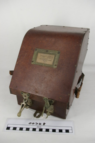 Frankston RSL Sub Branch
Sextant, Bubble
... This is an aviation navigation instrument used by the RAF and RAAF during the World War 2 era. A sextant is used to measure the altitude of celestial bodies above a horizontal line of reference. ...This is an aviation navigation instrument used by the RAF and RAAF during the World War 2 era. A sextant is used to measure the altitude of celestial bodies above a horizontal line of reference. ...Bubble Sextant model Mark 1XA type A.M. 6B/218 in protective storage box. Complete, with operation instructions. This is an aviation navigation instrument used by the RAF and RAAF during the World War 2 era. A sextant is used to measure the altitude of celestial bodies above a horizontal line of reference. A navigator can use the horizon as this line of reference, but when an aircraft is above the clouds or flying at night, the navigator can’t see the horizon. The bubble sextant solves this problem by providing an artificial horizon.The storage case has a label with the following: "A.M. 6B/218 MK IX A" and the number "10772/42 (V)" -
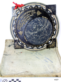 Flagstaff Hill Maritime Museum and Village
Planisphere, Early 20th Century
... A significant item of celestial mapping used by marine navigators This particular item was made and used in the first quarter to half of the 20th century flagstaff hill warrnambool shipwrecked-coast flagstaff-hill flagstaff-hill-maritime-museum maritime-museum shipwreck-coast flagstaff-hill-maritime-village planisphere star map marine navigation maps george philip & sons "Made in Germany for GEORGE PHILIP & SONS Ltd. ...The word Planisphere (Latin planisphaerium) was originally used in the second century by Claudius Ptolemy to describe the representation of a spherical Earth by a map drawn in the plane. This usage continued into the Renaissance: for example Gerardus Mercator described his 1569 world map as a Planisphere. The word describes the representation of the star-filled celestial sphere on the plane. The first star chart to have the name "Planisphere" was made in 1624 by Jacob Bartsch. Bartsch was the son-in-law of Johannes Kepler, discoverer of Kepler's laws of planetary motion. A significant item of celestial mapping used by marine navigators This particular item was made and used in the first quarter to half of the 20th centuryPlanisphere of northern hemisphere, with canvas bag. Planisphere consists of a circular star chart attached at its centre to an opaque circular overlay that has a clear elliptical window or hole so that only a portion of the sky map will be visible in the window or hole area at any given time. The chart and overlay are mounted so that they are free to rotate about a common pivot point at their centres. The star chart contains the brightest stars, constellations and (possibly) deep-sky objects visible from a particular latitude on Earth. The night sky that one sees from the Earth depends on whether the observer is in the northern or southern hemispheres and the latitude. A Planisphere window is designed for a particular latitude and will be accurate enough for a certain band either side of that. Planisphere makers will usually offer them in a number of versions for different latitudes. Planispheres only show the stars visible from the observer's latitude; stars below the horizon are not included. A complete twenty-four-hour time cycle is marked on the rim of the overlay. A full twelve months of calendar dates are marked on the rim of the starchart. The window is marked to show the direction of the eastern and western horizons. The disc and overlay are adjusted so that the observer's local time of day on the overlay corresponds to that day's date on the star chart disc. The portion of the star chart visible in the window then represents (with a distortion because it is a flat surface representing a spherical volume) the distribution of stars in the sky at that moment for the Planispheres designed location. Users hold the Planisphere above their head with the eastern and western horizons correctly aligned to match the chart to actual star positions. "Made in Germany for GEORGE PHILIP & SONS Ltd. Geographical and Educational Depot, 32 Fleet Street, London" Canvas bag has "Capt. H (Howard) Tyler from Captain H. F. Woolf" "Tyler 22 ? St East Brighton" also "13 Halls St Flinders"flagstaff hill, warrnambool, shipwrecked-coast, flagstaff-hill, flagstaff-hill-maritime-museum, maritime-museum, shipwreck-coast, flagstaff-hill-maritime-village, planisphere, star map, marine navigation, maps, george philip & sons -
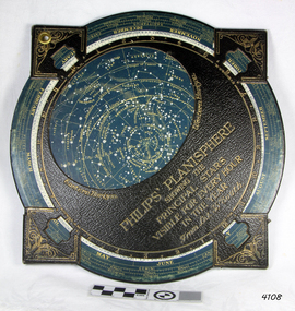 Flagstaff Hill Maritime Museum and Village
Planisphere, Early 20th Century
... Bartsch was the son-in-law of Johannes Kepler, discoverer of Kepler's laws of planetary motion A significant item of celestial mapping used by marine navigators This particular item was made and used in the first quarter to half of the 20th century. flagstaff hill warrnambool shipwrecked-coast flagstaff-hill flagstaff-hill-maritime-museum maritime-museum shipwreck-coast flagstaff-hill-maritime-village Star map marine navigation maps George Philip & Sons "Sold by J DONNE & SON, Booksellers & Stationers, 349 Post Office Place Melbourne 349. ...The word Planisphere (Latin planisphaerium) was originally used in the second century by Claudius Ptolemy to describe the representation of a spherical Earth by a map drawn in the plane. This usage continued into the Renaissance: for example Gerardus Mercator described his 1569 world map as a Planisphere. The word describes the representation of the star-filled celestial sphere on the plane. The first star chart to have the name "Planisphere" was made in 1624 by Jacob Bartsch. Bartsch was the son-in-law of Johannes Kepler, discoverer of Kepler's laws of planetary motionA significant item of celestial mapping used by marine navigators This particular item was made and used in the first quarter to half of the 20th century.Planisphere consists of a circular star chart attached at its centre to an opaque circular overlay that has a clear elliptical window or hole so that only a portion of the sky map will be visible in the window or hole area at any given time. The chart and overlay are mounted so that they are free to rotate about a common pivot point at their centers. The star chart contains the brightest stars, constellations and (possibly) deep-sky objects visible from a particular latitude on Earth. The night sky that one sees from the Earth depends on whether the observer is in the northern or southern hemispheres and the latitude. A Planisphere window is designed for a particular latitude and will be accurate enough for a certain band either side of that. Planisphere makers will usually offer them in a number of versions for different latitudes. Planispheres only show the stars visible from the observer's latitude; stars below the horizon are not included. A complete twenty-four-hour time cycle is marked on the rim of the overlay. A full twelve months of calendar dates are marked on the rim of the star chart. The window is marked to show the direction of the eastern and western horizons. The disc and overlay are adjusted so that the observer's local time of day on the overlay corresponds to that day's date on the star chart disc. The portion of the star chart visible in the window then represents (with a distortion because it is a flat surface representing a spherical volume) the distribution of stars in the sky at that moment for the Planispheres designed location. Users hold the Planisphere above their head with the eastern and western horizons correctly aligned to match the chart to actual star positions. "Sold by J DONNE & SON, Booksellers & Stationers, 349 Post Office Place Melbourne 349. Admiralty Chart Agents" and " Made in Germany for George Philip & Son Ltd" England . Signature "Capt E. B. ?..id, 22 Baund St"flagstaff hill, warrnambool, shipwrecked-coast, flagstaff-hill, flagstaff-hill-maritime-museum, maritime-museum, shipwreck-coast, flagstaff-hill-maritime-village, star map, marine navigation, maps, george philip & sons