Showing 13 items matching "chart reading"
-
 Queenscliffe Maritime Museum
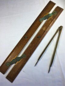
Equipment - A parallel ruler and dividers
... chart reading... Parallel Ruler Dividers Navigation chart reading A timber and brass ...Navigational equipmentNavigational equipment A timber and brass parallel ruler and brass dividersparallel ruler, dividers, navigation, chart reading -
 Orbost & District Historical Society
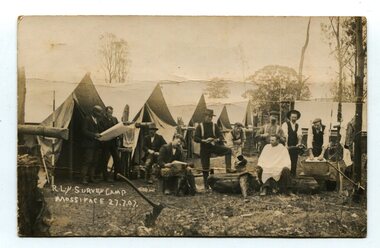
black and white photograph, July 27 1907
This is a camp of survey workers surveying the railway line . They were camped at Mossiface in 1907. It has been sent as a postcard - "Dear Miss Ross, Just a card, hoping you are well etc, trust you have not forgotten our trip. I forgot to get the name of the street in Hobart of Mr Benjamin or Temple?????? Sufficient. Yours sincerely H.R. Gordon". It has been dated September 30th 1907. There had been men surveying in East Gippsland from the late 19th century. Railway surveyors advocated two lines beyond Bairnsdale – one via Bruthen and the Tambo Valley to Omeo, the other via Swan Reach and Colquhoun to Orbost, then on to Bendoc and the border. With all the argument and feuding between the warring factions, by the end of 1891, the Parliamentary Railways Standing Committee gave up in despair of trying to reach any agreement and abandoned the idea altogether. Finally, with all problems solved, the first sod was turned at Mossiface on 9.1.1912, the government sticking to the original route in the 1890 survey .This is a pictorial record of a surveyors' camp in the early 20th century. The Bairnsdale to Orbost Railway was a significant contributor to the economy of Orbost until it closed.A black / white photograph / postcard of a group of men at a campsite. In the background is a row of tents. on the right side is a clothes line with several sheets hung over it. Two men are studying a map or chart; one man is sitting with a cloth around his shoulders while another is standing behind him cutting his hair; one man is washing cloth in a tin tub; another appears to be stirring a pot; others are sitting reading or just observing.on front - handwritten is " R.L.Y.S. SURVEY CAMP MOSSIFACE 27.7.07" on back is a letter - "Dear Miss Ross.............yours sincerely ????? Gordon"surveying-railway east-gippsland-railway mossiface-survey-camp -
 Federation University Historical Collection
Manual - Manual - Readings, VIOSH: Manual of Readings for Professional Extension Program in Occupational Hazard Management
... topic readings Spiral bound manual - charts and graphs VIOSH ...Manual of readings for various essay topics.Spiral bound manual - charts and graphsviosh, victorian institute of occupational safety and health, occupational hazard management, essay topic readings -
 Federation University Historical Collection
Document - Document - Letter, Ballarat Junior Technical School: Letters relating to equipment to establish a practice weather-observation station. 1952
.1: Letter from H B Selby & Co Pty Ltd re the order for a Fortin Barameter. Asking for arrangement for Staff member to collect as it is very fragile. The glassware for the Regnault Vapour pressure Apparatus not previously sent has been forwarded. .2: Letter from the school to The Director Weather Bureau Melbourne. Outlines establishing a weather-observing station as part of general science. Mr McLachlin in Ballarat will guide the school as to method, procedure, records, etc List of equipment on loan - Stevenson Screen, maximum and minimum thermometers, wet and dry bulb thermometers, 8" rain gauge, cloud chart, instructions for reductions of barometer readings, weather code for transmission, record book. 2 Cream pages, typed .1: Letterhead for H B Selby & Co Pty Ltd - Black and red inks Signature of V T Parkinson, Managerballarat junior technical school, head master, l garner, h b selby, weather bureau, weather station, observations, fortin barameter, regnault vapour pressure apparatus, stevenson screen, maximum thermometer, minimum thermometer, bulb thermometers, rain gauge, instructions, weather code, record book -
 Montmorency–Eltham RSL Sub Branch
Equipment - Navigational Computer
Rectangular calculating instrument with (1) 'hinged lid' fitted with circular rotating dial for setting/reading altitude, speed, distance and temperature, (2) notebook inside lid, (3) circular dial with perspex cover, beneath which is (4) graph chart, moveable up-and-down by means of rotating knob on side of device. Curved brackets and elasticized straps on back for strapping onto pilot's leg.R.A.A.F. Ident. No. G6B/145 Serial No. WG/2233 COMPUTER NAVIGATIONAL Mk. III D. (Other inscriptions including instructions for use and scales for various measurements) "AB" hand written on strap (owner's initials?) -
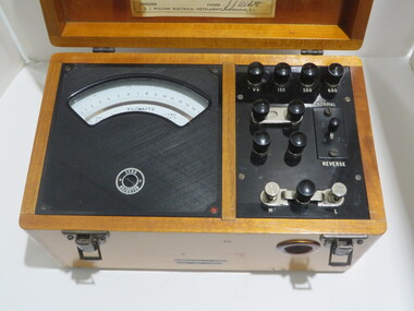 Federation University Historical Collection
Instrument - Scientific Instrument, Wattmeter: Type PW6
Would have been used in electrical engineering laboratory experiments. Slip inside of lid indicates that the instrument would have been checked at times for accuracy of readings. This was checked and passed on 28 November 1959.Wattmeter, portable, in varnished wood case with leather strap handle. Hinged lid with calibration chart inside the lid. Range - 0 to 1.5. Voltage ranges: 150v; 300v; 600vSerial No 2927 Dated: 28/11/58 Signature: J J Abbott A J William Electrical Instruments, Melbourne, C.1. Dymo tape on front side: WATTMETER 0 - 1.5 kwwattmeter, portable, electrical engineering, experiments, dynamometer type, scientific instrument -
 Bendigo Historical Society Inc.
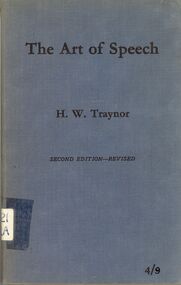
Book - GOLDEN SQUARE LAUREL STREET P.S. COLLECTION: THE ART OF SPEECH
The Art of Speech, A Note Book for Use in Speech Training and Oral English Lessons by H. W. Traynor. Second Edition-Revised. Hard cover book with mid blue cloth cover. Foreword by Professor J. J. Stable, M.A., The University of Queensland, Brisbane, February, 1940.Preface by H.W.T., Grimwade House, Melbourne Church of England Grammar School, 1939. Topics include Introductory; Voice and Speech; Respiration - The Act of Breathing; Phonetics; Vowels; Diphthongs; Consonants; On Reading Aloud; A Self-Correction Chart and Index of First Lines and Authors.education, primary, golden square laurel st p.s., golden square laurel street p.s. collection - the art of speech, h w traynor, australian music examination board, professor j j stable ma, whitcombe & tombs pty ltd, professor g h cowling, mr a j dunstan, hwt, australian educational quarterly april 1929 -
 Monbulk RSL Sub Branch
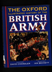
Book, David Chandler, The Oxford illustrated history of the British Army, 1994
From longbow, pike, and musket to Challenger tanks, from the Napoleonic Wars to the Gulf campaign, the Duke of Marlborough to Field Marshal Montgomery, The Oxford Illustrated History of the British Army recounts the history of the British army from its medieval antecedents to the present day. Drawing on the latest scholarship, this survey shows how British fighting forces have evolved over the last five centuries. The continuities revealed are sometimes surprising: narrow recruitment patterns, friction between soldiers and civilians, financial constraints and recurrent political pressure for economies are constant themes. Commanders, campaigns, battles, organization, and weaponry are covered in detail within the wider context of the social, economic, and political environment in which armies exist and fight. The British army has been remarkably successful in fighting terms, losing only one major war (of American Independence 1775-83). As one of the engines of empire it has been active all over the world, as well as shaping the internal destiny of the nation in civil war and revolution. Its history is charted in a sequence of chronological chapters, each containing special feature articles, beginning with the medieval, Elizabethan, and Restoration army and moving on through the eighteenth and nineteenth centuries to the two world wars of the twentieth. The book concludes with accounts of the army of British India, the amateur military tradition, the British way in warfare, and an assessment of what the future may hold in the light of the Options for Change review. Extensively illustrated in black and white and colour, and with a detailed chronology and further reading lists, this is the definitive one-volume history of the British army for specialists and non-specialists alike.Bibliography, Index, Chronology, ill (plates, col, b/w) maps. p.452.non-fictionFrom longbow, pike, and musket to Challenger tanks, from the Napoleonic Wars to the Gulf campaign, the Duke of Marlborough to Field Marshal Montgomery, The Oxford Illustrated History of the British Army recounts the history of the British army from its medieval antecedents to the present day. Drawing on the latest scholarship, this survey shows how British fighting forces have evolved over the last five centuries. The continuities revealed are sometimes surprising: narrow recruitment patterns, friction between soldiers and civilians, financial constraints and recurrent political pressure for economies are constant themes. Commanders, campaigns, battles, organization, and weaponry are covered in detail within the wider context of the social, economic, and political environment in which armies exist and fight. The British army has been remarkably successful in fighting terms, losing only one major war (of American Independence 1775-83). As one of the engines of empire it has been active all over the world, as well as shaping the internal destiny of the nation in civil war and revolution. Its history is charted in a sequence of chronological chapters, each containing special feature articles, beginning with the medieval, Elizabethan, and Restoration army and moving on through the eighteenth and nineteenth centuries to the two world wars of the twentieth. The book concludes with accounts of the army of British India, the amateur military tradition, the British way in warfare, and an assessment of what the future may hold in the light of the Options for Change review. Extensively illustrated in black and white and colour, and with a detailed chronology and further reading lists, this is the definitive one-volume history of the British army for specialists and non-specialists alike.great britain - military history, great britain - military tradition -
 Victorian Aboriginal Corporation for Languages
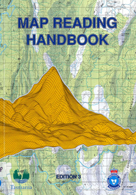
Book, Tasmania State Emergency Service, Map reading handbook, 1997
... photographs, charts, diagrams Map reading handbook Book Tasmania State ...maps, b&w photographs, charts, diagramsmaps reading, aerial photographic maps, global positioning systems, topographical maps, compasses -
 Department of Energy, Environment and Climate Action
Balloon Theodolite 1943
Used to measure the rate of rise of helium balloons The telescope is mounted on two movable axes. One axis (vertical) rotates to change elevation, the other (horizontal) azimuth. There are vernier scales and in some cases micrometres that give precise readouts of the relative position of the telescope to each axis. The instrument is set up so that it is level and it is pointed towards true north with both scales reading 0 degrees exactly. A balloon is released in front of the theodolite. It is sighted at timed intervals (usually one minute apart) and the position of the theodolite's telescope (azimuth and elevation) is recorded. It can chart the direction and velocity of winds at various altitudes The rate of ascent of a balloon is mostly dependant on the balloon's drag and its "free lift" (the vertical pull of the balloon). There is some degree of control over these these factors, and as a result, it possible to know approximately how high our balloon will be at any given time after its release. Given a known height and an angular direction (read off the theodolite) to the balloon, a fix is made of the horizontal movement component of the balloon's travel as it moves through different altitudes. The horizontal movement is due to the winds blowing the balloon around at the altitudes that the balloon is traveling throughTheodolite used to measure the rate of rising helium balloons The rate of rise is used in atmospheric calculations such as upper winds and determining inversion layersforests commission victoria (fcv), bushfire, weather -
 Bendigo Military Museum
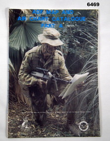
Document - ADF Map and Air Chart Catalogue Part A, RASvy Corps, May 1991
This document contains the "map and Air Chart Demand and Issue Voucher" to enable the ordering of map products. The catalogue of available products is shown on the reverse side to assist in the ordering process.1. A Map sheet of Australia folded to A4 in size. 2. A selection of map examples and a catalogue of products, Tactical Line Maps (TLM) at 1:50,000 scale to Digital Chart of the World (DCW) at 1:1,000,000 scale maps. The names of all the 1:100,000 maps are listed in alphabetical order. 3. The Map and Air Chart Demand and Issue Voucher is printed on the back of the document. 4. Front section has a photo of a soldier with a Steyr rifle kneeling reading a map.royal australian survey corps, rasvy, fortuna, army survey regiment, army svy regt, asr -
 Flagstaff Hill Maritime Museum and Village
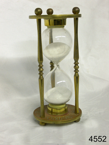
Instrument - Hourglass
An hourglass or sandglass is an instrument for measuring a defined time and can be used perpetually by simply turning it over immediately the top bulb empties. The clear blown glass is shaped into two equal sized bulbs with a narrow passage in the centre and contains uniform sized sand or glass particles in the lower bulb. The width of the neck regulates the constant flow of the particles. The glass is held in a stand with top and bottom of equal shape and size. Hourglasses can measure an infinite variety of time by gauging the size of the particles, the shape and size of the bulbs and the size of the passage between the bulbs, thus measuring hours or minutes or even seconds. Generally an hourglass sits between discs of wood at the ends, which are joined by long wooden spindles between the ends and tightened by screw caps. The length of time can be adjusted by adding or removing sand particles. The use of the marine sandglass (or hourglass) has been recorded in the 14th century in European shipping. A one minute sandglass was used in conjunction with the ship’s log for ‘dead reckoning’, (see below) that is, for measuring the ship’s speed through the water. They were also used to regulate ringing the ship’s timetable; for example a 4 hour sandglass was used for the length of the sailors’ watch, and a half hour timer for taking of readings for the ship’s log; the ship’s bell would be rung every half hour. It was usually the role of the cabin boy to watch and turn the sandglasses over at the exact time of them emptying their upper chambers and to ring the ship’s bell. Hourglasses have been used historically for many hundreds of years. Some have been used for timing church sermons, in cooking, in industry and at sea. Even today they are used for measuring the cooking time of eggs and timing a player’s turn in games such as Boggle and Pictionary. The sandglasses at sea were gradually replaced in the late 1700’s to early 1800’s by the more accurate chronometers (marine clocks) when they became reliable instruments. DEAD RECKONING (or Deduced Reckoning) Dead reckoning is the term used to describe the method of calculating the ship’s position from its speed and direction, used in early maritime travel, mostly in European waters. Both the (1) speed and the (2) direction of travel were recorded on a Traverse Board at half-hourly intervals during a helmsman’s watch of 4 hours. The navigator would record the readings in his ship’s log, plot them on his navigational chart and give his updated course directions to the next helmsman on watch, along with the cleared Traverse Board. This was a very approximate, but none-the-less helpful, method of navigation. The wooden Traverse Board was a simple pegboard with a diagram of a compass with eight peg holes along the radius to each of the compass points, plus a grid with ascending half hours in the left column and increasing ship’s speed in knots in a row across the column headings, with a peg hole in each of the intersecting cells. A number of wooden pegs were attached to strings on the board. By placing one peg consecutively in the direction’s radius hole, starting from the centre, and the speed holes when the half hourly reading was taken, a picture of speed and direction for the whole 4 hour watch was created. (1) To measure the ship’s speed a one minute hourglass timer was usually used to measure the ship’s speed through the water and help to calculate its longitude. A rope, with knots at regular standard intervals and a weight such as a log at the end, would be thrown overboard at the stern of the ship. At the same time the hourglass would be turned over and a seaman would start counting the number of knots on the rope that passed freely through his hands as the ship travelled. When the timer ran out the counting would be stopped. A timer of one minute (one-sixtieth of an hour), knots spaced one-sixtieth of a nautical mile apart, and simple arithmetic easily gave the speed of the ship in nautical miles per hour ("knots"). This would be recorded every half hour. The speed could however be inaccurate to the travel being affected by ocean currents and wind. (2) To calculate the ship’s direction a compass sighting would be recorded each half hour.Marine hourglasses or sandglasses were used from around the 14th to 19th century during the time of sailing ships. This hourglass is representative of that era, which is during the time of the colonisation of Australia. Hourglass or sandglass; an instrument used to measure time. Two equal sized clear glass bulbs joined with a narrow passage between them, containing equal sized particles of sand grains in lower bulb. Glass sits in a brass collar at each end, in a frame comprising 3 decorative brass columns or posts, each attached top and bottom, using round screw-on feet, to round brass discs. Disc have Roman numerals for the numbers 1 - 12 pressed into their inner surfaces and hieroglyphics on the outer surfaces. Roman numerals on inner surface of discs " I II III IV V VI VII VIII IX X XI XII " Hieroglyphics impressed on outer surface of discsflagstaff hill, warrnambool, shipwrecked coast, flagstaff hill maritime museum, maritime museum, shipwreck coast, flagstaff hill maritime village, great ocean road, horology, hourglass, hour glass, sandglass, sand glass, timing instrument, dead reckoning, deduced reckoning, finding latitude at sea, sandglass with hieroglyphics and roman numerals, hourglass with hieroglyphics and roman numerals, brass hourglass -
 Bendigo Military Museum
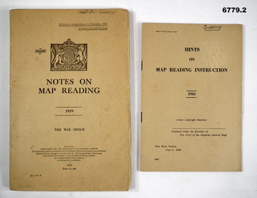
Manual - MAP READING, British War Office, 1929 - 1943
Items in the collection re Col J. Swatton, refer Cat No 6719.2P for his service details. 1. This is an Army Training Manual. on the front is the British Coat of Arms. The book's title dated 1929. Khaki cardboard cover. Printed in black ink. It has 93 pages of text, maps and drawings. 2. Small booklet, Khaki cover, Prtinted in black ink dated 1943. British War Office.1. On front cover is "Illegible" and W. Swatton. Inside front cover is handmade amendment chart. Daily entry is dated April 1938. On rear cover is a sticky label with the words "On loan from the Estate of Colonel J, W. Swatton" Ref No JWS M18. 2. On front cover is written name "Swatton". On rear cover is a sticky label with words..."On loan from the Estate of Colonel J. W. Swatton." Ref No JWS M19.map reading, j. w. swatton, passchendaele barracks trust