Showing 31 items matching "cherry farm"
-
 Mt Dandenong & District Historical Society Inc.
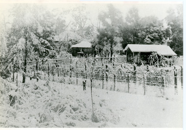
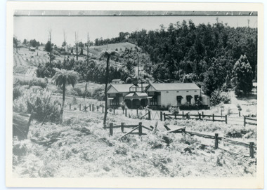
Photograph, Erith Lane
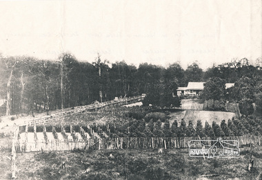
... ...Cherry Farm...Mabel Hand, Thomas and Eliza's youngest daughter stated that she was born in the bark hut in 1881 and they moved into the new home the same year. Cherry Farm, the roof visible behind the centre building, was the home of William Hand, son of Thomas and Eliza. ...Large roof behind it was “Cherry Farm”....Large roof behind it was “Cherry Farm”. Black and white photograph showing a scene under heavy snow. ...Erith Lane would have been named after Eliza Erith, the wife of Thomas Hand of Mountain Grange. The house made of slabs and bark pictured (centre) is where the family lived before Mountain Grange was built. Mabel Hand, Thomas and Eliza's youngest daughter stated that she was born in the bark hut in 1881 and they moved into the new home the same year. Cherry Farm, the roof visible behind the centre building, was the home of William Hand, son of Thomas and Eliza. He lived here with hs wife, Harriet Toghill, before moving to live at Mountain Grange after 1905.Black and white photograph showing a scene under heavy snow. Two cottages and a rooftop visible. Snow laden vines forming the front fence. Taller trees visible in the background. Reverse of photograph has handwritten description by John Lundy-Clarke.Erith Lane under snow. House in passion fruit Ivory’s holiday home 1921. Building in centre was Hand’s 28’ by 22’ house of slabs and bark. The first house on top of the whole Dandenong Range built 1871. Large roof behind it was “Cherry Farm”.eliza erith, eliza hand, mabel hand, thomas hand, william hand, erith lane, kalorama, snow, mountain grange, cherry farm, harriet toghill -
 Whitehorse Historical Society Inc.
Photograph, Highland Avenue Mitcham, No.38
... cherry tree farm...This is the last piece of land that was originally part of Cherry Tree Farm...This is the last piece of land that was originally part of Cherry Tree Farm Highland Avenue Mitcham, No.38 Photograph Photograph ...Three coloured photographs of the clearing of 38 Highland Avenue, Mitcham in 2006. This is the last piece of land that was originally part of Cherry Tree Farmcherry tree farm, mitcham, highland avenue, no.38, farming -
 Mt Dandenong & District Historical Society Inc.
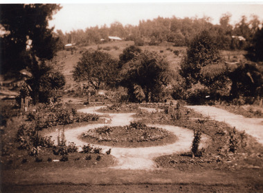
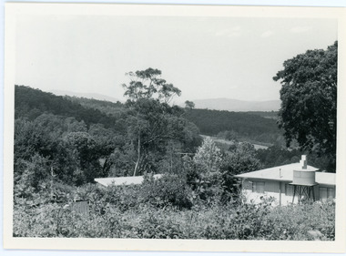
Photograph, The New Garden Mountain Grange Kalorama 1931, 1931
... On the right there is a house among the trees. Possibly Cherry Farm....On the right there is a house among the trees. Possibly Cherry Farm. The New Garden Mountain Grange Kalorama 1931 Photograph ...Garden with circular paths and the side of the hill in background. On the right there is a house among the trees. Possibly Cherry Farm.mountain grange -
 Mt Dandenong & District Historical Society Inc.
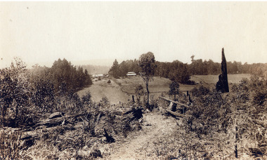
Photograph, Mountain Grange and Great Barn Kalorama
... View taken from "Cherry Farm" hill looking across farm (now the Kalorama Memorial Reserve), which was the property of Thomas and Eliza Hand. ...View taken from "Cherry Farm" hill looking across farm (now the Kalorama Memorial Reserve), which was the property of Thomas and Eliza Hand. ...Copy of a postcard titled "Looking Towards Healesville". View taken from "Cherry Farm" hill looking across farm (now the Kalorama Memorial Reserve), which was the property of Thomas and Eliza Hand. Location recognised because of likeness to a painting.eliza hand, mountain grange, thomas hand -
 Mt Dandenong & District Historical Society Inc.
Photograph, View Up Valley At Kalorama
... The other places were ‘Mountjoy’, ‘Cherry Farm’ and ‘Callum House’. ‘Kia-Ora’ was burnt down in 1924. ...The other places were ‘Mountjoy’, ‘Cherry Farm’ and ‘Callum House’. ‘Kia-Ora’ was burnt down in 1924. ...John Lundy-Clarke grew up in the Kalorama/Mt Dandenong area and later in life (1972-74) began to write a comprehensive history of the area working from an original settlement map in an effort to cover all areas. The building in the centre of the photograph is 'Kia-Ora' guest house. Situated on Barber’s Road, ‘Kia-Ora’ was built in 1912 by George Barber. It was later leased by a Mrs Pemberthy. “Kia-Ora’ was one of four places connected when the telephone was brought into the district in 1912. The other places were ‘Mountjoy’, ‘Cherry Farm’ and ‘Callum House’. ‘Kia-Ora’ was burnt down in 1924. Black and White copy of section of a Rose Series postcard. Shows view up the valley at Kalorama with a decorative building centre middle of photograph. Handwritten description by John Lundy-Clarke on reverse.View up valley at Kalorama from near junction of Barbers and Doughty’s Rds. “Kia Ora” guest house in centre. Paynter’s “Iona” top left with “Kalorama” to its right. About 1912. Rose Series copied by JLC 1973.kalorama, kalorama valley, john lundy-clarke, barbers road, george barber, kia-ora, guest house, iona -
 Mt Dandenong & District Historical Society Inc.
Photograph, View From Ernest Road To Site Of "Kia-Ora"
... The other places were ‘Mountjoy’, ‘Cherry Farm’ and ‘Callum House’. ‘Kia-Ora’ was burnt down in 1924....The other places were ‘Mountjoy’, ‘Cherry Farm’ and ‘Callum House’. ‘Kia-Ora’ was burnt down in 1924. ...John Lundy-Clarke grew up in the Kalorama/Mt Dandenong area and later in life (1972-74) began to write a comprehensive history of the area working from an original settlement map in an effort to cover all areas. The photograph taken c1973 from Ernest Road looks over the site of the Kia-Ora guesthouse which is marked by the oalm tree that can be seen at the front of the flat roof close to the gum tree trunk. Situated on Barber’s Road, ‘Kia-Ora’ was built in 1912 by George Barber. It was later leased by a Mrs Pemberthy. “Kia-Ora’ was one of four places connected when the telephone was brought into the district in 1912. The other places were ‘Mountjoy’, ‘Cherry Farm’ and ‘Callum House’. ‘Kia-Ora’ was burnt down in 1924.Black and white photograph showing a house with water tank in right foreground and another flat roof centre foreground. There is a handwritten description by John Lundy-Clarke on the reverse.View 1973 from corner of Ernest Rd and Outlook Drive Lot 24 Village Settlement looking over the site of “Kia Ora” to the pioneers clearings. The palm tree seen above the flat roof (Rex) on left, is on the exact site of “Kia Ora”. Photo JLCernest road, john lundy-clarke, kia=ors, guest house, guesthouse -
 Mt Dandenong & District Historical Society Inc.
Photograph, Jasper Road Near Erith Lane 1920, 1920
... It was put in as a road to serve “Cherry Farm”, connecting it to the Coach Road at the Elbow in 1904. ...It was put in as a road to serve “Cherry Farm”, connecting it to the Coach Road at the Elbow in 1904. ...View of Jasper Road, near Erith Lane taken in 1920. The road is tree lined with two significant gum trees in the foreground. This photograph has a detailed inscription on the back handwritten by John Lundy-Clarke in 1974.Jasper Road near Erith Lane 1920. This road has only a narrow right of way. It was put in as a road to serve “Cherry Farm”, connecting it to the Coach Road at the Elbow in 1904. It joins a wide surveyed road running from Inverness Road to the Coach Road at the Elbow and could possibly have been surveyed by Thomas Hand at the same time as Inverness Road. The name Jasper now applies to full length between Erith Lane and Coach Road. McGivern Bros widened it in 1937 and J L Clarke removed and stored much of the rock quarried in the widening. This was later sold to Dick Moorby who sold it to the builders of St Michaels Church in Falls Road. Comment by John Lundy-Clarke 10.5.1974 jasper road, erith lane, john lundy-clarke -
 Orbost & District Historical Society
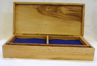
wooden box, McLean, Don, Just prior to January 2010
... This box was crafted from a portion of one of the original oak trees in the Jarrahmond WW11 Avenue of Honour.The Avenue was planted in 1955 and linked the farms of the two servicemen from Jarrahmond who lost their lives in WWII. It consisted of English Oaks interspersed with flowering peaches and cherries. ...Orbost & District Historical Society Ruskin Street Orbost gippsland This box was crafted from a portion of one of the original oak trees in the Jarrahmond WW11 Avenue of Honour.The Avenue was planted in 1955 and linked the farms of the two servicemen from Jarrahmond who lost their lives in WWII. It consisted of English Oaks interspersed with flowering peaches and cherries. ...This box was crafted from a portion of one of the original oak trees in the Jarrahmond WW11 Avenue of Honour.The Avenue was planted in 1955 and linked the farms of the two servicemen from Jarrahmond who lost their lives in WWII. It consisted of English Oaks interspersed with flowering peaches and cherries. Wood for the box was collected in the early 1990's by Stan Weatherall following a windstorm. Stan had the timber rough-sawn into planks by local sawmiller Max Reynolds. The timber was stored for a number of years before being given to Don McLean.A hand-made oak box. The inside base is lined in green felt. The lid is single hinged. the front panel displays a radiating pattern in the grain of the oak wood that resembles the rising sun badge of the Australian Defence Forces. Two brass pins are symbols of Australian military regalia. Inside the box is an envelope with information and letters on the manufacture of the box and presentation to Orbost. The information concerns the Jarrahmond School and the Avenue of Honour.handcraft oak jarrahmond-avenue-of-honour container -
 Eltham District Historical Society Inc
Photograph - Digital Photograph, Alan King, Panton Hill Hotel, 27 March 2008
... farms to feed the diggers. Farmers grew wheat, barley and oats, and sent animal skins to the Eltham tannery, to make furs in Melbourne. As gold became scarce from around 1880, miners took up farming on 19 to 20 acre (8ha) allotments. The first settlers in Cherry...farms to feed the diggers. Farmers grew wheat, barley and oats, and sent animal skins to the Eltham tannery, to make furs in Melbourne. As gold became scarce from around 1880, miners took up farming on 19 to 20 acre (8ha) allotments. The first settlers in Cherry ...Today’s Panton Hill Hotel was built around 1920. Published: Nillumbik Now and Then / Marguerite Marshall 2008; photographs Alan King with Marguerite Marshall.; p61 Panton Hill was originally known as Kingstown, and consisted of only one hotel when the Orams Reef was discovered in 1859. Kingstown was a quartz mining centre and many old mine shafts remain in the area. Orams Reef was one of the first reefs with a rich find of gold in the area. The Hotel Francais, which had been operating in 1861, was well situated on the way to Queenstown (later St Andrews). So was Herr Hirt’s Hotel and store at Smiths Gully. The Kingstown hotel, known as the Frenchman’s and in 1864 as the Hotel de France, was run by a Monsieur Emile Hude and his wife Jeanne, and known for its good food. They hosted social events, business conventions and debates, attracting patrons from as far as Melbourne. The hotel’s name was changed to Panton Hill Hotel in 1905. In 1883 Charles Caudwell built another hotel nearby, possibly in Long Gully Road,3 which it is thought, was burnt down early last century. Today’s Panton Hill Hotel, built around 1920, is the only one of the cluster of buildings in the main road, not to date from around the turn of last century. It was severely damaged by fire in 2003, then underwent extensive alterations. It is the township’s only hotel and is an example of a modest hotel building exterior, constructed early last century. In its early days the hotel also housed the first post office, newsagency and store. Orams Reef yielded a total of £100,000, and fossikers also found alluvial gold in the creeks and gullies, but there is no record of the total value of their finds. Gold greatly increased the Panton Hill population, which peaked between 1865 and 1885. On holidays large sports meetings were held with wood chopping contests and foot races and the day would end with a ball. Miners came from various countries to seek their fortune, including many from China. The Chinese became unpopular however, and gradually left the district, although some stayed and grew and sold vegetables.5 Panton Hill was named after Joseph Panton, who in 1862 was appointed Police Magistrate for the Woods Point, Heidelberg and Yarra districts. Panton was an outstanding man, who in 1852, was Commissioner of Crown Lands and Assistant Commissioner of Goldfields at Bendigo. In 1874 he was promoted to Chief Magistrate for the Melbourne Police. Panton was also an artist, becoming president of the Victorian Arts Society in 1888, and in 1913, president of the Royal Geographical Society. Despite Panton Hill’s prosperity, it still lacked many services as poor roads made access to Melbourne difficult. A horse-drawn mail coach travelled to Melbourne until 1890, when the railway came to Heidelberg. The nearest doctor was at Yarra Glen or Heidelberg, and the Indian hawker Singh’s annual visit was very welcome. A miner’s shack opposite the school was used as a post office. Today’s general store and post office in the main road dates from early last century, and has changed considerably. While most people searched for gold, the more enterprising ones established farms to feed the diggers. Farmers grew wheat, barley and oats, and sent animal skins to the Eltham tannery, to make furs in Melbourne. As gold became scarce from around 1880, miners took up farming on 19 to 20 acre (8ha) allotments. The first settlers in Cherry Tree Road included Purcell, Smith, Owens, Hughes and Shillinglaw. By 1900 all the land had been taken up around Panton Hill and Hurstbridge. The orchards in Panton Hill and the wider district, particularly of apple and pear, were very successful, and made Panton Hill a cohesive and successful community. About 1914 the Moores built the first cool-store and refrigeration plant at their orchard in Cherry Tree Road. Many settlers planted vineyards and made high quality wine, but in 1922 the blight destroyed them.This collection of almost 130 photos about places and people within the Shire of Nillumbik, an urban and rural municipality in Melbourne's north, contributes to an understanding of the history of the Shire. Published in 2008 immediately prior to the Black Saturday bushfires of February 7, 2009, it documents sites that were impacted, and in some cases destroyed by the fires. It includes photographs taken especially for the publication, creating a unique time capsule representing the Shire in the early 21st century. It remains the most recent comprehenesive publication devoted to the Shire's history connecting local residents to the past. nillumbik now and then (marshall-king) collection, panton hill hotel -
 Eltham District Historical Society Inc
Photograph, Cant house and farm, Salters Rush
... Photocopy of image of house and farm of William and Jessie Cant, Salters Rush, Queenstown. The orchard grew cherries, apples, plums, pears, quinces and berries - raspberry, blackberry, gooseberry, red currants and black currants. ...Eltham District Historical Society Inc 728 Main Rd Eltham melbourne houses farming orchards salters rush queenstown smiths gully william cant jessie cant Photocopy of image of house and farm of William and Jessie Cant, Salters Rush, Queenstown. The orchard grew cherries, apples, plums, pears, quinces and berries - raspberry, blackberry, gooseberry, red currants and black currants. ...Photocopy of image of house and farm of William and Jessie Cant, Salters Rush, Queenstown. The orchard grew cherries, apples, plums, pears, quinces and berries - raspberry, blackberry, gooseberry, red currants and black currants. Also vegetables and flowers. All cultivation done by hand. (Chancellor photograph)houses, farming, orchards, salters rush, queenstown, smiths gully, william cant, jessie cant -
 Eltham District Historical Society Inc
Film - Video (DVD), Frank Stokes, Stokes Family, 1950-1977
... farmed the neighbouring orchard. Early 1943 he took possession and would catch the train out to Eltham on Fridays after work and began building a hut for shelter and to lock up tools. He was able to pay a neighbour (Hawkins) to help with clearing and fencing 25 acres and with a horse and single furrowed plow, planted approximately 2,500 fruit trees - cherries, peaches, plums, almonds, pears, apricots and lemons as well as a few apples and oranges; a massive job. ...farmed the neighbouring orchard. Early 1943 he took possession and would catch the train out to Eltham on Fridays after work and began building a hut for shelter and to lock up tools. He was able to pay a neighbour (Hawkins) to help with clearing and fencing 25 acres and with a horse and single furrowed plow, planted approximately 2,500 fruit trees - cherries, peaches, plums, almonds, pears, apricots and lemons as well as a few apples and oranges; a massive job. ...Various family scenes taken from outside the family home on the southeast corner of the intersection of Nyora Road and Pitt Street with Eucalyptus Road. Also, scenes of the Stokes Orchard and equipment used, construction of water reservoir at the end of Nyora Road near Reynolds Road and Diosma Road as well as early stages of the Stokes Orchard housing development. Frank Stokes worked as a qualified accountant at Kennons leather factory in Burnley, while living at 1 Thomas Street, Mitcham. He suffered from migraines and wanted to go back to the land (he had previously worked on farms and orchards since coming to Australia in 1926 both in WA and Vic.). He first travelled to the district by train in July 1942 to find land with the intention to establish an orchard. By chance he met Arthur Bird of Bird Orchard (bounded by Pitt Street, Eucalyptus Road and Wattle Grove) and they got talking over their common interest. Arthur put Frank up for the night and pointed out the land, 158 acres- Taylor Estate- £900, part of Crown Allotment 15, Section 5, Parish of Nillumbik (CA15) somewhat diagonally opposite Bird Orchard. He applied through the Riverina Agency to purchase the land who in turn had to get permission from Canberra to sell as there was a new government regulation banning land sales except for immediate production. He obtained a loan on his Mitcham house of £600 @ 5% and paid £450 deposit with quarterly payments of £15 over 5 years. The title to the property was issued May 15, 1946. He was helped and advised by Arthur Bird who farmed the neighbouring orchard. Early 1943 he took possession and would catch the train out to Eltham on Fridays after work and began building a hut for shelter and to lock up tools. He was able to pay a neighbour (Hawkins) to help with clearing and fencing 25 acres and with a horse and single furrowed plow, planted approximately 2,500 fruit trees - cherries, peaches, plums, almonds, pears, apricots and lemons as well as a few apples and oranges; a massive job. A huge problem was hares and rabbits eating all the new buds off the tiny trees. As well as laying poison he painted the trees with a mixture of cow manure and lime. Often working by moonlight. It was extremely difficult to get wire and wire netting because of the war but after much effort he obtained a permit from the Agricultural Department for supplies in March 1944. In February 1945 he applied for a permit to build a “packing shed” as no house building allowed. It was to be 33 feet x 21 feet and cost £312. Constructed mostly from second-hand materials, which was hard to obtain, especially iron for roofing. Frank finished work at Kennons October 31, 1945, and in March 1946 he sold the Mitcham house for £1230 plus £170 for furniture. The family of five then moved into a very unfinished at Eltham, which was a struggle to weatherproof. Eventually rooms were divided off and lined with hessian bags and whitewashed. Their income was firewood (cut and sold), selling rockery stones and cut sweet bursaria. (It was discovered during the 1940s that Bursaria contained the sunscreen compound Aesculin. The RAAF utilised this compound from Bursaria during WW2 for pilots and gunners.) The orchard’s first fruit sale was a 1/2 case of Le Vanq peaches in December 1947 - 8 shillings. In 1956 plans for house were drawn and Glen Iris bricks purchased (1956 Olympic Rings variant). The building of the house commenced in 1957 - 12 feet of original packing shed removed – and was completed in 1959. Water was connected from newly built pressure storage on the property at the end of 1959 and the electricity connection for the first time at 3pm on April 29, 1960. In the mid-1970s the Shire of Eltham divided the orchard up into numerous rate-able parcel lots, which became unaffordable for Frank. Consequently, Stokes Orchard was turned into a housing development by Macquarie Builders and marketed as the Stokes Orchard Estate in two stages; Stage 1 encompassing Scarlet Ash Court, Ironbark Close and Peppermint Grove bounded by Nyora and Eucalyptus roads c.1976 and Stage 2 encompassing Stokes Place, Orchard Way, The Crest and The Lookout bound by Nyora and Diosma roads c.1979. The development of Orchard Way, The Crest and The Lookout did not proceed as planned due to the lack of the sewer along Diosma Road and so many of the proposed lots were incorporated into five-acre parcels instead. With the arrival of the sewer along Diosma Road many years later, most of these five-acre parcels have since been subdivided many times.Representative of the orchard growing areas of ElthamMP4 00:24:39; 426MB Digital file only - Digitised by EDHS from a DVD copy on loan from Beryl Bradbury (nee Stokes), daughter of Frank Stokes. 24 min duration compilation of home movie Super 8mm film shot by Frank Stokes brother-in-law.beryl bradbury (nee stokes) collection, frank stokes, nyora road, stokes orchard, stokes orchard estate, stokes place, video recording -
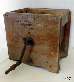 Flagstaff Hill Maritime Museum and Village
Domestic object - Butter Churn, Cherry and Sons, 1890-1920
... The Cherry works specialised in making all types of butter churns and equipment for both domestic use on farms and small butter factories during the late nineteenth and early to mid. twentieth centuries. ...The Cherry works specialised in making all types of butter churns and equipment for both domestic use on farms and small butter factories during the late nineteenth and early to mid. twentieth centuries. ...The subject item is a good example of a large, hand-operated Bentwood box butter churn used to make up to 14 pounds of butter. It was made in Gisborne, Victoria, by the famous manufacturer, E. Cherry, and is known as an Improved Patent No.2 model probably dating from the late 1800s. The Cherry works specialised in making all types of butter churns and equipment for both domestic use on farms and small butter factories during the late nineteenth and early to mid. twentieth centuries. Milk was "separated" to retrieve the cream which was then beaten to make butter. E Cherry began making various models of Cherry butter churns in 1858, Edward Cherry migrated from Herefordshire England to Australia in 1855 with his wife Ann Appleby, nee Davis, and established a joinery workshop at Gisborne, Victoria. He began by making butter churns in his spare time and his product soon became popular allowing him to establish a viable business. A factory was established in 1875 and he started to make churns of all sizes including up to industrial scale. He exported his products to many countries around the world, Edward Cherry died in 1909 and the business was then run by his son George until he died in 1917. E Cherry's other son Thomas (1861-1945) was also involved in the firm maintaining an interest for several years. He had been born in Gisborne and became a senior house medical surgeon at the Melbourne Hospital in 1890. He continued his studies at Kings College London, eventually becoming a renowned bacteriologist and agricultural scientist. A significant item giving an snapshot into how early industrial manufacturing became established in Australia in the production of domestic and industrial dairy equipment.Butter churn wooden manually operated made by Cherry and Sons with rotating lever curved plywood basin and parallel cross beamed horizontally spoken churning apparatus inside with wooden plug at lower side of churn. Label in block transfer "E CHERRY / MAKER / GISBORN / VICTORIA / 2" "IMPROVED PATENT"warrnambool, shipwrecked-coast, flagstaff-hill, flagstaff-hill-maritime-museum, maritime-museum, shipwreck-coast, flagstaff-hill-maritime-village, butter churn, wooden butter churn, e cherry & sons, dairy equipment, gisborne, food preparation -
 Ringwood and District Historical Society
Map - Public Land Sale by Thomas Ham, 2000 Acres for Sale - Crown Sections 20, 23, 24 - Ringwood, Victoria - 1855
... Cherry Tree and Stringy Bark, with Wattle in the valleys of the several creeks. Every lot is Staked and Trenched at the corners marked on the Plan thus - The Surveyor has carefully sub-divided the Property, in order to give every Farm a Creek for Water, Valley for Cultivation, and Hills for House and Grass Paddock. ...Cherry Tree and Stringy Bark, with Wattle in the valleys of the several creeks. Every lot is Staked and Trenched at the corners marked on the Plan thus - The Surveyor has carefully sub-divided the Property, in order to give every Farm a Creek for Water, Valley for Cultivation, and Hills for House and Grass Paddock. ...Two 1850s surveyor's maps on cardboard backing showing area from Melbourne extending East beyond Bulleen and Nunawading. Detailed description of lots for sale and navigational directions to the property from Richmond by Thomas Ham, Victorian public servant, map maker, publisher, lithographer and original Ringwood land owner. Inset map enlarging area between Yarra River and Dandenong Creek, with southern boundary of allotments later forming part of Oban Road, North Ringwood.TRANSCRIPT: "This really valuable Property is now offered to the public for sale, in lots to suit purchasers at the Iow rate of £1 per Acre for 80 acres and upwards, and £1.10s per Acre for any smaller portion. Terms of payment Half Cash, Balance in 6 and 12 months, bearing 8 per cent interest. The Estate is well wooded with Gum, Cherry Tree and Stringy Bark, with Wattle in the valleys of the several creeks. Every lot is Staked and Trenched at the corners marked on the Plan thus - The Surveyor has carefully sub-divided the Property, in order to give every Farm a Creek for Water, Valley for Cultivation, and Hills for House and Grass Paddock. The ROADS have been very carefully laid out so as to give a firm, well drained, and nearly level road to each Homestead. Intending purchasers can readily find the property by the following directions, viz: Start from Richmond Bridge, at Hawthorne, then take the left-hand road to KEW. When at the "Woodman Inn", take the Cotham Road to the right, bearing due east, keep this Road, passing Trainor's "White Horse" Inn, and before you leave the fences, you will see calico bills (see margin) nailed to the Trees on the bush track leading to the Upper Yarra country, follow the Bills till you come to the SOUTH boundary line of the Property, which bears East and West (see Plan) where you will see Bills nailed up "THIS PROPERTY FOR SALE, etc." The Bills from Town lead direct to where Mr. Jull is erecting his Store, and arrangements have been made with him to show the lots to intending purchasers free of charge. At the respective corners of the lots the Bills are nailed up double, with numbers to denote the lot, and that the corner stake is adjacent. Any parties wishing to proceed to the property by way of BULLEEN will find Bills nailed on the Trees, commencing at the NEW INN, at "Wilson's Slip Rail." Keep this Track till you come to the Log Bridge, over the Deep Creek at Bloxhome's Paddock; go through the land now being cleared; keep the track over the hill till you come to an Iron House, you will then be on the property, which Iies to the North and East as per Plan. Follow the Bills till you come to Mr. Jull's Store, etc. etc. Further particulars can be had from the Agent for the Property. THOMAS HAM. " -
 Flagstaff Hill Maritime Museum and Village
Domestic object - Butter Churn, Cherry and Sons, Circa 1890-1920
... The Cherry works specialised in making all types of butter churns and equipment for both domestic use on farms and small butter factories during the late nineteenth and early to mid. twentieth centuries. ...The Cherry works specialised in making all types of butter churns and equipment for both domestic use on farms and small butter factories during the late nineteenth and early to mid. twentieth centuries. ...The subject item is a good example of a large, hand-operated Bentwood box butter churn used to make up to 14 pounds of butter. It was made in Gisborne, Victoria, by the famous manufacturer, E. Cherry, and is known as an Improved Patent No.2 model probably dating from the late 1800s. The Cherry works specialised in making all types of butter churns and equipment for both domestic use on farms and small butter factories during the late nineteenth and early to mid. twentieth centuries. Milk was "separated" to retrieve the cream which was then beaten to make butter. E Cherry began making various models of Cherry butter churns in 1858, Edward Cherry migrated from Herefordshire England to Australia in 1855 with his wife Ann Appleby, nee Davis, and established a joinery workshop at Gisborne, Victoria. He began by making butter churns in his spare time and his product soon became popular allowing him to establish a viable business. A factory was established in 1875 and he started to make churns of all sizes including up to industrial scale. He exported his products to many countries around the world, Edward Cherry died in 1909 and the business was then run by his son George until he died in 1917. E Cherry's other son Thomas (1861-1945) was also involved in the firm maintaining an interest for several years. He had been born in Gisborne and became a senior house medical surgeon at the Melbourne Hospital in 1890. He continued his studies at Kings College London, eventually becoming a renowned bacteriologist and agricultural scientist. A significant giving an snapshot into how early rural and industrial manufacturing became established in Australia.Rectangular butter churn, a footed wooden box containing an X-shaped wooden interior rack, which is joined to an exterior metal hand crank with turned wood handle, through a hole in the box. Beneath the hand crank is a hole from the interior lined with metal. The lid has a carry handle affixed to the lid on two cross pieces attached to the lid by brass screws.Lettering in black on a transfer "CHERRY & SONS PTY LTD. GISBORNE VICTORIA". Model 00warrnambool, shipwrecked-coast, flagstaff-hill, flagstaff-hill-maritime-museum, flagstaff-hill-maritime-village, butter churn, gisborne, edward cherry, george cherry, thomas cherry, ann appleby, dairy equipment -
 Flagstaff Hill Maritime Museum and Village
Domestic object - Butter Churn, Cherry and Sons, 1890-1920
... The Cherry works specialised in making all types of butter churns and equipment for both domestic use on farms and small butter factories during the late nineteenth and early to mid. twentieth centuries. ...The Cherry works specialised in making all types of butter churns and equipment for both domestic use on farms and small butter factories during the late nineteenth and early to mid. twentieth centuries. ...The subject item is a good example of a large, hand-operated Bentwood box butter churn used to make up to 14 pounds of butter. It was made in Gisborne, Victoria, by the famous manufacturer, E. Cherry, and is known as an Improved Patent No.2 model probably dating from the late 1800s. The Cherry works specialised in making all types of butter churns and equipment for both domestic use on farms and small butter factories during the late nineteenth and early to mid. twentieth centuries. Milk was "separated" to retrieve the cream which was then beaten to make butter. E Cherry began making various models of Cherry butter churns in 1858, Edward Cherry migrated from Herefordshire England to Australia in 1855 with his wife Ann Appleby, nee Davis, and established a joinery workshop at Gisborne, Victoria. He began by making butter churns in his spare time and his product soon became popular allowing him to establish a viable business. A factory was established in 1875 and he started to make churns of all sizes including up to industrial scale. He exported his products to many countries around the world, Edward Cherry died in 1909 and the business was then run by his son George until he died in 1917. E Cherry's other son Thomas (1861-1945) was also involved in the firm maintaining an interest for several years. He had been born in Gisborne and became a senior house medical surgeon at the Melbourne Hospital in 1890. He continued his studies at Kings College London, eventually becoming a renowned bacteriologist and agricultural scientist. A significant giving an snapshot into how early industrial manufacturing became established in Australia.Rectangular manual butter churn, footed wooden box containing an X-shaped wooden interior rack, which is joined to an exterior metal hand crank with turned wood handle, through a hole in the box. Beneath the hand crank is a hole from the interior lined with metal. The lid has a carry handle affixed to the lid on two cross pieces attached to the lid by brass screws.Label in block transfer Manufactured by Cherry & Sons Pty Ltd Gisborne, Victoria Size "00"flagstaff hill, warrnambool, shipwrecked-coast, flagstaff-hill, flagstaff-hill-maritime-museum, maritime-museum, shipwreck-coast, flagstaff-hill-maritime-village, butter churn, cherry and sons, wooden butter churn -
 Marysville & District Historical Society
Map (Item) - Tourist and business map, Narbethong Community and Tourism Group, Narbethong Buxton Taggerty Tourist and Business Map, 04-2008
... A tourist and business map of Narbethong, Buxton and Taggerty. narbethong buxton taggerty victoria australia tourist and business map narbethong community and tourism group acheron valley yarra track wood's point black spur mystic mountains the meeting of the waters cathedral range danico design counted cross stitch things of sand & stone buxton zoo nursery & oddz & enz willowbank at taggerty safe trek 4wd services pnl 4wdriving buxton trout and salmon farm mystic mountains ski hire & outdoors narbethong ski hire highwood health centre cathedral view natural therapies narby cabinets plants by shelian gb timber executive signs rb automotive repairs buxton car care marysville towing & equipment hire martyn slade building design cathedral peak framing black spur roadhouse & ski hire tudor lodge roadhouse & ski hire buxton roadhouse & persian bazzar buxton post office general store & niche bar igloo roadhouse taggerty store narby eggs marapana agistment park mantirri blueberry farm carmyle farm hazelwood hazelnuts south cathedral lavender farm cathedral cherries black spur motel & caravan park woodlands rainforest retreat chestnut glade black spur inn wombat cottage abbey lake luxury b & b spa cottages blue views holiday cottages camp narbethong marapana farm stay b & b mantirri blueberry farm b & b little dene garden cottages silverstream b & b cottages nareen cabins moondai farm b & b south cathedral farm luxury b & b cottages yarrolyn caravan park sarsens rest lomah retreat pinjarra gardens kingbilli country estate henry viii manor house buxton hotel butters cafe of buxton wagtail wines little river wines lanterns at willowbank wirrawilla rainforest walk wilhemina falls the cascades This publication has been produced by the Narbethong Community and Tourism/ Group (NCTG) to promote the natural attractions, adventure activities and food/ trail from the Black Spur, through Narbethong, Buxton and Taggerty./ the information provided in this publication has been supplied by the individual/ members. ...A tourist and business map of Narbethong, Buxton and Taggerty. This map was produced by the Narbethong Community and Tourism Group in April 2008. It was produced to promote the natural attractions, adventure activities and food trail from the Black Spur, through Narbethong, Buxton and Taggerty.A tourist and business map of Narbethong, Buxton and Taggerty.This publication has been produced by the Narbethong Community and Tourism/ Group (NCTG) to promote the natural attractions, adventure activities and food/ trail from the Black Spur, through Narbethong, Buxton and Taggerty./ the information provided in this publication has been supplied by the individual/ members. NCTG takes no responsibility for its accuracy./ April 2008narbethong, buxton, taggerty, victoria, australia, tourist and business map, narbethong community and tourism group, acheron valley, yarra track, wood's point, black spur, mystic mountains, the meeting of the waters, cathedral range, danico design counted cross stitch, things of sand & stone, buxton zoo nursery & oddz & enz, willowbank at taggerty, safe trek 4wd services, pnl 4wdriving, buxton trout and salmon farm, mystic mountains ski hire & outdoors, narbethong ski hire, highwood health centre, cathedral view natural therapies, narby cabinets, plants by shelian, gb timber, executive signs, rb automotive repairs, buxton car care, marysville towing & equipment hire, martyn slade building design, cathedral peak framing, black spur roadhouse & ski hire, tudor lodge roadhouse & ski hire, buxton roadhouse & persian bazzar, buxton post office general store & niche bar, igloo roadhouse, taggerty store, narby eggs, marapana agistment park, mantirri blueberry farm, carmyle farm, hazelwood hazelnuts, south cathedral lavender farm, cathedral cherries, black spur motel & caravan park, woodlands rainforest retreat, chestnut glade, black spur inn, wombat cottage, abbey lake luxury b & b spa cottages, blue views holiday cottages, camp narbethong, marapana farm stay b & b, mantirri blueberry farm b & b, little dene garden cottages, silverstream b & b cottages, nareen cabins, moondai farm b & b, south cathedral farm luxury b & b cottages, yarrolyn caravan park, sarsens rest, lomah retreat, pinjarra gardens, kingbilli country estate, henry viii manor house, buxton hotel, butters cafe of buxton, wagtail wines, little river wines, lanterns at willowbank, wirrawilla rainforest walk, wilhemina falls, the cascades -
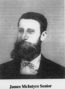 Sunshine and District Historical Society Incorporated
Photograph - James McIntyre family, circa 1860s
... Photograph of James McIntyre Senior an Irish assisted migrant came out in 1841 followed by several relatives He married Bridget Dodd and by the early 1850s owned land in the north Sunshine Kealba area Their farm was known as Riversdale Both James and Bridget died in 1885 Photograph of Maria Cherry nee McIntyre, who married James Cherry in 1869 in two ceremonies one at St Augustines in Keilor the other at the Presbyterian Church in Footscray Photograph of the inside of St Augustines church in Keilor...James McIntyre Photograph of James McIntyre Senior an Irish assisted migrant came out in 1841 followed by several relatives He married Bridget Dodd and by the early 1850s owned land in the north Sunshine Kealba area Their farm was known as Riversdale Both James and Bridget died in 1885 Photograph of Maria Cherry nee McIntyre, who married James Cherry in 1869 in two ceremonies one at St Augustines in Keilor the other at the Presbyterian Church in Footscray Photograph of the inside of St Augustines church in Keilor James McIntyre family Photograph James McIntyre family ...Photograph of James McIntyre Senior an Irish assisted migrant came out in 1841 followed by several relatives He married Bridget Dodd and by the early 1850s owned land in the north Sunshine Kealba area Their farm was known as Riversdale Both James and Bridget died in 1885 Photograph of Maria Cherry nee McIntyre, who married James Cherry in 1869 in two ceremonies one at St Augustines in Keilor the other at the Presbyterian Church in Footscray Photograph of the inside of St Augustines church in Keilorjames mcintyre -
 Sunshine and District Historical Society Incorporated
Archive - Truganina & Derrimut
... Truganina Derrimut Typed notes A history of Truganina by Geo F Green 1935|Newspaper article The Sun 19 August 1973 Truganini|Handwritten notes 7 December Map of historic buildings roads drainage lines from Frances Overmars|Handwritten notes Alberts Plan Compiled by Albert James Evans who was born 6 April 1916|Typed notes Ancestry For Sarah and James Tout 1879 and Edward and Marion Elizabeth Richards 1890 and Annie and William Mitchell 1882 and Louisa and George and Elizabeth and John Opie 1871 and Charles and Maria Blackman 1878 and James and Margaret Rose 1875 and John Doherty and Jane Evans 1869 and William Doherty and Fanny Rebecca Scales 1867 and Jane Elizabeth and James Henry Evans 1867 and Louisa and William Cherry 1869|Extract The Plains of Iramoo by Esther Murray|Newspaper article The Sun 19 August1978 Truganini 98 years in a museum|Newspaper article Wandering around Werribee|Newspaper article The Western Times 19 March 1986 Wandering around Werribee|Handwritten notes Ancestry for Elizabeth Doherty Conner|Photocopy of map Tarneit Deutgam Derrimut Werribee Truganina & Derrimut|A History of Truganina by George F Green 1935|Farms of the district|Families of the district Archive Truganina & Derrimut ...Typed notes A history of Truganina by Geo F Green 1935|Newspaper article The Sun 19 August 1973 Truganini|Handwritten notes 7 December Map of historic buildings roads drainage lines from Frances Overmars|Handwritten notes Alberts Plan Compiled by Albert James Evans who was born 6 April 1916|Typed notes Ancestry For Sarah and James Tout 1879 and Edward and Marion Elizabeth Richards 1890 and Annie and William Mitchell 1882 and Louisa and George and Elizabeth and John Opie 1871 and Charles and Maria Blackman 1878 and James and Margaret Rose 1875 and John Doherty and Jane Evans 1869 and William Doherty and Fanny Rebecca Scales 1867 and Jane Elizabeth and James Henry Evans 1867 and Louisa and William Cherry 1869|Extract The Plains of Iramoo by Esther Murray|Newspaper article The Sun 19 August1978 Truganini 98 years in a museum|Newspaper article Wandering around Werribee|Newspaper article The Western Times 19 March 1986 Wandering around Werribee|Handwritten notes Ancestry for Elizabeth Doherty Conner|Photocopy of map Tarneit Deutgam Derrimut Werribeetruganina, derrimut -
 Clunes Museum
Functional object - CHERRY CHEESE PRESS
... Clunes Museum 36 Fraser Street enter building through Collins Place Clunes goldfields CHEESE PRESS WAS DONATED FROM ONE OF THE ORIGINAL FARMS IN THE DUNACH DISTRICT FROM THE ESTATE OF MAVIS HARRIS DUNACH local history domestic item food preparation SEE MAKER DETAILS [BELOW} CHEERY CHEESE PRESS AND ACCESSORIES. WOODEN FRAME WITH IRON PRESS AND WOODEN STAND Functional object CHERRY ...CHEESE PRESS WAS DONATED FROM ONE OF THE ORIGINAL FARMS IN THE DUNACH DISTRICT FROM THE ESTATE OF MAVIS HARRIS DUNACHCHEERY CHEESE PRESS AND ACCESSORIES. WOODEN FRAME WITH IRON PRESS AND WOODEN STANDSEE MAKER DETAILS [BELOW}local history, domestic item, food preparation -
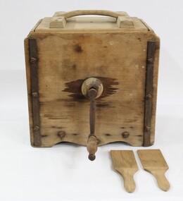 Wodonga & District Historical Society Inc
Functional object - Butter Churn - late 1800s - early 1900s, E. Cherry & Sons
... It has interpretative potential in the areas of local agricultural history, and the social history of food and farming. butter butter churn dairy cream milk cow agriculture farms farmers farm food social history food history A wooden butter churn with metal turning handle, and two butter paddles and removal lid. Butter Churn - late 1800s - early 1900s Functional object Butter Churn - late 1800s - early 1900s E. Cherry ...North east Victoria was a major dairy producing region in the late nineteenth century. The first iteration of the Wodonga Butter Factory Ltd was established in 1892. Dairy was sent from farmers across the district for processing at the factory in Wodonga in the 1890s. Victorian creameries regularly exported frozen butter to London, stock was transported by rail for sale in Melbourne, and of course sold and consumed locally. E.W. Mann, of the prominent local Wodonga family, was a shareholder and was closely involved in the establishment of the Wodonga Butter Company. Many families living on farms also owned their own cow, and had equipment to process their own dairy products at home. This item has strong links to the history of Wodonga and north east Victoria. It has interpretative potential in the areas of local agricultural history, and the social history of food and farming.A wooden butter churn with metal turning handle, and two butter paddles and removal lid.butter, butter churn, dairy, cream, milk, cow, agriculture, farms, farmers, farm, food, social history, food history -
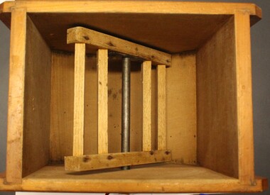 Wodonga & District Historical Society Inc
Domestic object - Small Butter Churn, E. Cherry & Sons, c1880 - 1920
... farms also owned their own cow for family needs and produced their milk and butter. This churn is representative of the equipment they used to process their own dairy products at home. This churn was made by E. Cherry...farms also owned their own cow for family needs and produced their milk and butter. This churn is representative of the equipment they used to process their own dairy products at home. This churn was made by E. Cherry ...North east Victoria was a major dairy producing region in the late nineteenth century. The Wodonga Butter Factory Ltd was established in 1892. Many families living in the town or on farms also owned their own cow for family needs and produced their milk and butter. This churn is representative of the equipment they used to process their own dairy products at home. This churn was made by E. Cherry & Sons which was established in Gisborne, Victoria in 1858. Edward Cherry (1830-1910) arrived in Australia from Hertfordshire, England, in 1855. The business manufactured churns and in 1875 opened a larger factory. On his death, the business was taken over by his son and continued to operate until the 1970s.This item has strong links to the history of Wodonga and north east Victoria. It has interpretative potential in the areas of local agricultural history, and the social history of food and farming.A wooden butter churn with metal turning handle and removable lid. The wooden paddle inside is attached to the turning handle which rotates to churn the butter. The model number is T1. It was probably made by E Cherry & Sons of Gisborne although the brand is blurred.On one side in black: "T 1"butter churns, dairying industry, domestic appliances, e. cherry churns -
 Whitehorse Historical Society Inc.
Domestic object - Glass butter churn
... Cherry butter churns. In the 1980s it was passed on to their daughter, Patricia Gibbons having only been used at several Farm Day Demonstrations in the previous sixty years....Cherry butter churns. In the 1980s it was passed on to their daughter, Patricia Gibbons having only been used at several Farm Day Demonstrations in the previous sixty years. glass technology glassware Large glass container, iron mechanism with tin lid for container and a wooden paddle. ...Nothing is known about the origin. IN 1895 Emma Blanche Annie Dear married Alfred Ernest Wellard, a young Methodist Minister in Tasmania and this was her churn. The Wellards used it in both Tasmania and Victoria. Later, it was handed on to their daughter Winsome Faith when she married Archibald Dufty, a farmer from the Wimmera. By then it was kept as an interesting relic of earlier days, as farming families in the 1920s and 1930s usually made their butter in Cherry butter churns. In the 1980s it was passed on to their daughter, Patricia Gibbons having only been used at several Farm Day Demonstrations in the previous sixty years.Large glass container, iron mechanism with tin lid for container and a wooden paddle. Wooden handle to turn cog mechanism.glass technology, glassware -
 Wonga Park Community Cottage History Group
Photograph - Painting, The Hedge, Yarra Road Wonga Park
... It was mixed farming: lemons, cherries, eggs, chickens and Gladys bred Spaniel dogs too. They had 2 dairy cows and a draft horse. The farm...It was mixed farming: lemons, cherries, eggs, chickens and Gladys bred Spaniel dogs too. They had 2 dairy cows and a draft horse. The farm ...The Hedge, aka Thomas Knee's house. Thomas Samuel Knee (born c. 1881in Lilydale) married Jane Maggs c. 1912, Thomas Samuel Knee's father Thomas Knee (married to Sarah Hardidge and who it appears was also an orchardist in Yarra Road) was rated for the land as vacant land at the turn of the century (c. 1900) Thomas Samuel Knee rated as owner of vacant land (CA14B of over 20 acres1911-12 and as a house 1912-13, next year CA 14C added making a total of 39 acres. It appears that Thomas Samuel Knee and his wife Jane lived at the property until 1949 when they moved to Montrose. In 1949 it was purchased by Hubert Victor (Vic) Eggleton after they migrated from Banstead in Surrey England. They had four boys Peter (who did a lot of the farming with Gladys), Brian, Michael and Roger. It was mixed farming: lemons, cherries, eggs, chickens and Gladys bred Spaniel dogs too. They had 2 dairy cows and a draft horse. The farm was larger then and was subdivided at a later date. The big dam was added too. the painting of the house was painted by a cousin of the Lusks. Ownership: Thomas Samuel Knee 1912-1949, Eggletons, 1949 - c.1953, then Timms, c. 1953 - early 1970s then Lusks early 1970s to c. 2012. The Lusks built a new house and after that the old house had various tenants. -
 Wonga Park Community Cottage History Group
Photograph - Colour, The Hedge (Tom Knee's House) 278 Yarra Road Wonga Park in 2023
... It was mixed farming: lemons, cherries, eggs, chickens and Gladys bred Spaniel dogs too. They had 2 dairy cows and a draft horse. The farm...It was mixed farming: lemons, cherries, eggs, chickens and Gladys bred Spaniel dogs too. They had 2 dairy cows and a draft horse. The farm ...The Hedge, aka Thomas Knee's house. Thomas Samuel Knee (born c. 1881in Lilydale) married Jane Maggs c. 1912, Thomas Samuel Knee's father Thomas Knee (married to Sarah Hardidge and who it appears was also an orchardist in Yarra Road) was rated for the land as vacant land at the turn of the century (c. 1900) Thomas Samuel Knee rated as owner of vacant land (CA14B of over 20 acres1911-12 and as a house 1912-13, next year CA 14C added making a total of 39 acres. It appears that Thomas Samuel Knee and his wife Jane lived at the property until 1949 when they moved to Montrose. In 1949 it was purchased by Hubert Victor (Vic) Eggleton after they migrated from Banstead in Surrey England. They had four boys Peter (who did a lot of the farming with Gladys), Brian, Michael and Roger. It was mixed farming: lemons, cherries, eggs, chickens and Gladys bred Spaniel dogs too. They had 2 dairy cows and a draft horse. The farm was larger then and was subdivided at a later date. The big dam was added too. the painting of the house was painted by a cousin of the Lusks. Ownership: Thomas Samuel Knee 1912-1949, Eggletons, 1949 - c.1953, then Timms, c. 1953 - early 1970s then Lusks early 1970s to c. 2012. The Lusks built a new house and after that the old house had various tenants. -
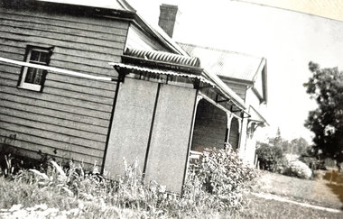 Wonga Park Community Cottage History Group
Photograph - Black and White, The Hedge (Tom Knee's House) 278 Yarra Road Wonga Park in 1949
... It was mixed farming: lemons, cherries, eggs, chickens and Gladys bred Spaniel dogs too. They had 2 dairy cows and a draft horse. The farm...It was mixed farming: lemons, cherries, eggs, chickens and Gladys bred Spaniel dogs too. They had 2 dairy cows and a draft horse. The farm ...The Hedge, aka Thomas Knee's house. Thomas Samuel Knee (born c. 1881in Lilydale) married Jane Maggs c. 1912, Thomas Samuel Knee's father Thomas Knee (married to Sarah Hardidge and who it appears was also an orchardist in Yarra Road) was rated for the land as vacant land at the turn of the century (c. 1900) Thomas Samuel Knee rated as owner of vacant land (CA14B of over 20 acres1911-12 and as a house 1912-13, next year CA 14C added making a total of 39 acres. It appears that Thomas Samuel Knee and his wife Jane lived at the property until 1949 when they moved to Montrose. In 1949 it was purchased by Hubert Victor (Vic) Eggleton after they migrated from Banstead in Surrey England. They had four boys Peter (who did a lot of the farming with Gladys), Brian, Michael and Roger. It was mixed farming: lemons, cherries, eggs, chickens and Gladys bred Spaniel dogs too. They had 2 dairy cows and a draft horse. The farm was larger then and was subdivided at a later date. The big dam was added too. the painting of the house was painted by a cousin of the Lusks. Ownership: Thomas Samuel Knee 1912-1949, Eggletons, 1949 - c.1953, then Timms, c. 1953 - early 1970s then Lusks early 1970s to c. 2012. The Lusks built a new house and after that the old house had various tenants. -
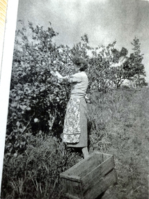 Wonga Park Community Cottage History Group
Photograph - Black and White, Wonga Park: Gladys Eggleton picking lemons between 1949 and 1953
... It was mixed farming: lemons, cherries, eggs, chickens and Gladys bred Spaniel dogs too. They had 2 dairy cows and a draft horse. The farm...It was mixed farming: lemons, cherries, eggs, chickens and Gladys bred Spaniel dogs too. They had 2 dairy cows and a draft horse. The farm ...The Hedge, aka Thomas Knee's house. Thomas Samuel Knee (born c. 1881in Lilydale) married Jane Maggs c. 1912, Thomas Samuel Knee's father Thomas Knee (married to Sarah Hardidge and who it appears was also an orchardist in Yarra Road) was rated for the land as vacant land at the turn of the century (c. 1900) Thomas Samuel Knee rated as owner of vacant land (CA14B of over 20 acres1911-12 and as a house 1912-13, next year CA 14C added making a total of 39 acres. It appears that Thomas Samuel Knee and his wife Jane lived at the property until 1949 when they moved to Montrose. In 1949 it was purchased by Hubert Victor (Vic) Eggleton after they migrated from Banstead in Surrey England. They had four boys Peter (who did a lot of the farming with Gladys), Brian, Michael and Roger. It was mixed farming: lemons, cherries, eggs, chickens and Gladys bred Spaniel dogs too. They had 2 dairy cows and a draft horse. The farm was larger then and was subdivided at a later date. The big dam was added too. the painting of the house was painted by a cousin of the Lusks. Ownership: Thomas Samuel Knee 1912-1949, Eggletons, 1949 - c.1953, then Timms, c. 1953 - early 1970s then Lusks early 1970s to c. 2012. The Lusks built a new house and after that the old house had various tenants. -
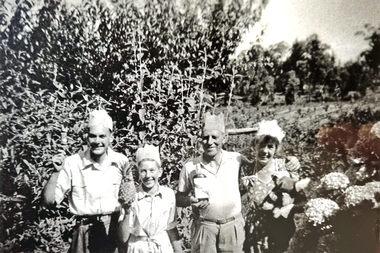 Wonga Park Community Cottage History Group
Photograph - Black and White, Wonga Park: Eggleton family's first Christmas in Australia 1949
... It was mixed farming: lemons, cherries, eggs, chickens and Gladys bred Spaniel dogs too. They had 2 dairy cows and a draft horse. The farm...It was mixed farming: lemons, cherries, eggs, chickens and Gladys bred Spaniel dogs too. They had 2 dairy cows and a draft horse. The farm ...The Hedge, aka Thomas Knee's house. Thomas Samuel Knee (born c. 1881in Lilydale) married Jane Maggs c. 1912, Thomas Samuel Knee's father Thomas Knee (married to Sarah Hardidge and who it appears was also an orchardist in Yarra Road) was rated for the land as vacant land at the turn of the century (c. 1900) Thomas Samuel Knee rated as owner of vacant land (CA14B of over 20 acres1911-12 and as a house 1912-13, next year CA 14C added making a total of 39 acres. It appears that Thomas Samuel Knee and his wife Jane lived at the property until 1949 when they moved to Montrose. In 1949 it was purchased by Hubert Victor (Vic) Eggleton after they migrated from Banstead in Surrey England. They had four boys Peter (who did a lot of the farming with Gladys), Brian, Michael and Roger. It was mixed farming: lemons, cherries, eggs, chickens and Gladys bred Spaniel dogs too. They had 2 dairy cows and a draft horse. The farm was larger then and was subdivided at a later date. The big dam was added too. the painting of the house was painted by a cousin of the Lusks. Ownership: Thomas Samuel Knee 1912-1949, Eggletons, 1949 - c.1953, then Timms, c. 1953 - early 1970s then Lusks early 1970s to c. 2012. The Lusks built a new house and after that the old house had various tenants. -
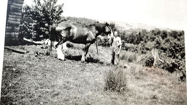 Wonga Park Community Cottage History Group
Photograph - Black and White, Wonga Park: Peter Eggleton with Captain, a draught horse between 1949 and 1953
... It was mixed farming: lemons, cherries, eggs, chickens and Gladys bred Spaniel dogs too. They had 2 dairy cows and a draft horse. The farm...It was mixed farming: lemons, cherries, eggs, chickens and Gladys bred Spaniel dogs too. They had 2 dairy cows and a draft horse. The farm ...The Hedge, aka Thomas Knee's house. Thomas Samuel Knee (born c. 1881in Lilydale) married Jane Maggs c. 1912, Thomas Samuel Knee's father Thomas Knee (married to Sarah Hardidge and who it appears was also an orchardist in Yarra Road) was rated for the land as vacant land at the turn of the century (c. 1900) Thomas Samuel Knee rated as owner of vacant land (CA14B of over 20 acres1911-12 and as a house 1912-13, next year CA 14C added making a total of 39 acres. It appears that Thomas Samuel Knee and his wife Jane lived at the property until 1949 when they moved to Montrose. In 1949 it was purchased by Hubert Victor (Vic) Eggleton after they migrated from Banstead in Surrey England. They had four boys Peter (who did a lot of the farming with Gladys), Brian, Michael and Roger. It was mixed farming: lemons, cherries, eggs, chickens and Gladys bred Spaniel dogs too. They had 2 dairy cows and a draft horse. The farm was larger then and was subdivided at a later date. The big dam was added too. the painting of the house was painted by a cousin of the Lusks. Ownership: Thomas Samuel Knee 1912-1949, Eggletons, 1949 - c.1953, then Timms, c. 1953 - early 1970s then Lusks early 1970s to c. 2012. The Lusks built a new house and after that the old house had various tenants.