Showing 42 items matching "chesterville"
-
 City of Kingston
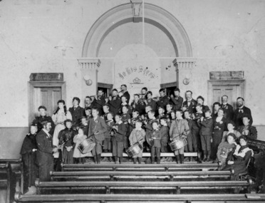
Photograph - Digital image, Black and white, Fife and Drum boys at Church of Christ, Chesterville Road, Cheltenham, c. 1900
... Fife and Drum boys at Church of Christ, Chesterville Road, Cheltenham......Chesterville...Fife and Drum boys at Church of Christ, Chesterville Road, Cheltenham...City of Kingston Parkdale Library 96 Parkers Road, Parkdale Parkdale Fife and Drum boys at Church of Christ, Chesterville Road, Cheltenham Fife Drum Boys Church Church of Christ Chesterville Cheltenham Round red sticker: X6 [crossed out] Handwritten in black ink: CHAP 4? ...Fife and Drum boys at Church of Christ, Chesterville Road, CheltenhamBlack and white image of boys standing on a a church alter and front row pews holding fife and drumsRound red sticker: X6 [crossed out] Handwritten in black ink: CHAP 4? / Boys Band Handwritten in blue ink and circled: A14/ Handwritten in red ink: 72% fife, drum, boys, church, church of christ, chesterville, cheltenham -
 Marysville & District Historical Society
Photograph (Item) - Black and white photograph, 1962
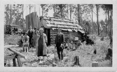
... ...chesterville...A digital copy of the Kirwan Chesterville at the Golden Secret Mine in 1962....A digital copy of the Kirwan Chesterville at the Golden Secret Mine in 1962....A digital copy of the Kirwan Chesterville at the Golden Secret Mine in 1962. kirwan chesterville golden secret mine marysville victoria australia cumberland A digital copy of the Kirwan Chesterville at the Golden Secret Mine in 1962. ...A digital copy of the Kirwan Chesterville at the Golden Secret Mine in 1962.A digital copy of the Kirwan Chesterville at the Golden Secret Mine in 1962.kirwan, chesterville, golden secret mine, marysville, victoria, australia, cumberland -
 City of Moorabbin Historical Society (Operating the Box Cottage Museum)
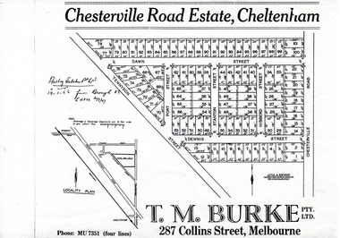
Flyer - Chesterville Road Estate, Cheltenham, 1947
... Chesterville Road Estate, consisting of 101 building lots, was sold by private sale in late 1947....Chesterville Road Estate, Cheltenham - plan of subdivision...Example of the progress of the Municipality of Moorabbin Tennyson Street Port Street Dennis Street Station Street Dawn Street Hubbard Street Chesterville Road Cheltenham real estate auction Chesterville Road Estate, Cheltenham - plan of subdivision Photocopy of advertising flyer for sale of real estate sales - plan of building blocks for sale Flyer Chesterville Road Estate, Cheltenham ...Chesterville Road Estate, consisting of 101 building lots, was sold by private sale in late 1947.Example of the progress of the Municipality of MoorabbinPhotocopy of advertising flyer for sale of real estate sales - plan of building blocks for saleChesterville Road Estate, Cheltenham - plan of subdivisiontennyson street, port street, dennis street, station street, dawn street, hubbard street, chesterville road, cheltenham, real estate, auction -
 City of Kingston
Pamphlet - Colour, R. Malcolm Estate Agents et al, Last Chance Land Sale Heritage Estate Cheltenham, c.1994
... Sales plan for land in the suburb of Cheltenham, bounded by Chesterville Road and Bernard Street, and incorporating Clendon Court, Tintern Grove and Tintern Mews...Incorporates a map of the estate bordered by Chesterville Road and Bernard Street, and including Clenton Court, Tintern Grove and Tintern Mews....Incorporates a map of the estate bordered by Chesterville Road and Bernard Street, and including Clenton Court, Tintern Grove and Tintern Mews. ...Sales plan for land in the suburb of Cheltenham, bounded by Chesterville Road and Bernard Street, and incorporating Clendon Court, Tintern Grove and Tintern MewsThis land sale pamphlet illustrates one of the last subdivisions of the century in Cheltenham, incorporating house and land packages. It shows that land sales and subdivision for the area had slowed considerably by the end of the 1900s and that the infrastructure was significantly developed. Colour pamphlet advertising last chance land sale of Heritage Estate Cheltenham. Incorporates a map of the estate bordered by Chesterville Road and Bernard Street, and including Clenton Court, Tintern Grove and Tintern Mews.cheltenham, land sales, estate -
 City of Moorabbin Historical Society (Operating the Box Cottage Museum)
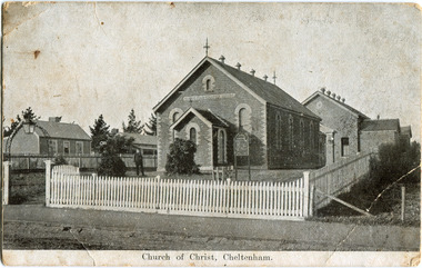
Photograph - Black & White Postcard, Cheltenham Church of Christ 40th Anniversary Invitation, c1900
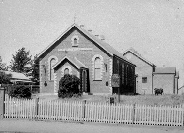
... They were able to buy land near the corner of Chesterville and Nepean Roads, and erected a new brick chapel on the site in 1878. ...Black & White photograph as a postcard invitation to the 40th Anniversary of the Church of Christ corner Chesterville Rd and Nepean Highway Cheltenham ( ? ...They were able to buy land near the corner of Chesterville and Nepean Roads, and erected a new brick chapel on the site in 1878. ...On his arrival from Scotland c 1857, James Keir commenced a communion service in his home on the Nepean Road. By 1859 the group-which included such other names as Allen, Brough, Cameron, Fairlam, Holdsworth, Le Page, Meeres, Monk, Organ, Penny, Perry, Potts, Sears and King-had built a small chapel near the corner of Wickham and Chesterville Roads. During 1858, a group had also begun meeting in the Charman family home on the corner of Charman and Balcombe Roads. Names associated with this group included Bodley, Charman, Fisher, Hayes, Hilliar, Judd, Moysey and Ruse. In 1860 they built a chapel on the corner of Charman Road and Patty Street. It was enlarged in 1866 and it became the meeting place of the two groups when they came together around 1870. They were able to buy land near the corner of Chesterville and Nepean Roads, and erected a new brick chapel on the site in 1878. This chapel, of course, continues to be an integral part of the life of the Southern Community Church and was one of the three worship venues for the 150th Anniversary celebration in 2007. The Southern Community Church was formed by the amalgamation of the Cheltenham, East Bentleigh and Hampton Street Churches of Christ in 1993, and a comprehensive new facility was designed and built to accommodate the ever-increasing activity of the amalgamated church. It was opened on 30th November 1997. ( Southern Community Church website 2019)c1878 - continuing The Church or Christ Cheltenham was one of the first places of worship established in Cheltenham by the early settlers. The settlers came together, in private homes at first, to support each other spiritually and physically and later built brick Churches for Sunday services and established social and sporting clubsBlack & White photograph as a postcard invitation to the 40th Anniversary of the Church of Christ corner Chesterville Rd and Nepean Highway Cheltenham ( ? 1900)Front Printed ; Church of Christ Cheltenham Back Printed ; POST CARD / One Penny Postage within Commonwealth / The address only to be written here/ One penny Stamp/ Sunday School Anniversary, / OCTOBER 27TH & OCTOBER 30TH / TO WHICH YOU ARE / CORDIALLY INVITED Handwritten in ink ; H.W. got the cramps in the pants. He took some pills then ran over the hills undatedearly settlers, bentleigh, mckinnon, parish of moorabbin, city of moorabbin, county of bourke, moorabbin roads board, shire of moorabbin, were j.b., o'shannassy john, king richard, charman stephen, highett william, ormond francis, maynard dennis, market gardeners, vineyards, orchards, keir james, lepage frank, lepage everest, holloway josiah, bruton henry, keys robert, judd clarence, fairlam percy, meeres william, southern community church, cheltenham, cheltenham church of christ -
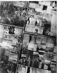 City of Kingston
Photograph - Black and white, c. 1944
... ...Chesterville...Aerial photograph of Moorabbin, including Chesterville Road, Keys Road and Wickham Road, Moorabbin, Briggs cottage, Neill's waterhole, McKittrick property, site of FRUMEL...City of Kingston Parkdale Library 96 Parkers Road, Parkdale Parkdale Aerial photograph of Moorabbin, including Chesterville Road, Keys Road and Wickham Road, Moorabbin, Briggs cottage, Neill's waterhole, McKittrick property, site of FRUMEL Moorabbin City of Moorabbin Chesterville Keys Wickham Handwritten in red ink on reverseL A 603 / 97% [in red circle] Handwritten in blue ink on reverse: 9502 06111 / M'bbin Black and white aerial view of Moorabbin. ...Aerial photograph of Moorabbin, including Chesterville Road, Keys Road and Wickham Road, Moorabbin, Briggs cottage, Neill's waterhole, McKittrick property, site of FRUMELBlack and white aerial view of Moorabbin. Houses, market garens, roads, and water features are all clearly visible.Handwritten in red ink on reverseL A 603 / 97% [in red circle] Handwritten in blue ink on reverse: 9502 06111 / M'bbinmoorabbin, city of moorabbin, chesterville, keys, wickham -
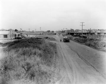 City of Kingston
Photograph - Black and white, 1957
... Black and white photograph of the intersection of South Road and Chesterville Road, Moorabbin. A service station is visible on the left hand side, a truck is travelling along the road and shops are under construction on the right hand side....Moorabbin Shopping strip Paddocks Roads Cars Handwritten in blue ink on reverse: 57-523B Handwritten in red ink on reverse: 100% Black and white photograph of the intersection of South Road and Chesterville Road, Moorabbin. A service station is visible on the left hand side, a truck is travelling along the road and shops are under construction on the right hand side. ...This image shows the increasing urbanisation of the formerly rural area of Moorabbin.Black and white photograph of the intersection of South Road and Chesterville Road, Moorabbin. A service station is visible on the left hand side, a truck is travelling along the road and shops are under construction on the right hand side.Handwritten in blue ink on reverse: 57-523B Handwritten in red ink on reverse: 100%moorabbin, shopping strip, paddocks, roads, cars -
 City of Moorabbin Historical Society (Operating the Box Cottage Museum)
Booklet - Cheltenham Church of Christ - Our Heritage - The History of the Cheltenham Church of Christ, by K. G. Hilbig and G. L. Daff, 1970
... Cheltenham Church of Christ was opened in 1878 and is still in use today. Built on Chesterville Road, Cheltenham....City of Moorabbin Historical Society (Operating the Box Cottage Museum) Joyce Park Jasper Road Ormond melbourne Cheltenham Church of Christ was opened in 1878 and is still in use today. Built on Chesterville Road, Cheltenham. Cheltenham Church of Christ was opened in 1878 and was integral to the spiritual well being and social life of the early settlers. early settlers parish of moorabbin city of moorabbin county of bourke shire of moorabbin market gardeners Cheltenham Nepean Highway Church of Christ Cheltenham Religion Chesterville Road Booklet 10 pages with typed text by K. ...Cheltenham Church of Christ was opened in 1878 and is still in use today. Built on Chesterville Road, Cheltenham.Cheltenham Church of Christ was opened in 1878 and was integral to the spiritual well being and social life of the early settlers.Booklet 10 pages with typed textearly settlers, parish of moorabbin, city of moorabbin, county of bourke, shire of moorabbin, market gardeners, cheltenham, nepean highway, church of christ cheltenham, religion, chesterville road -
City of Moorabbin Historical Society (Operating the Box Cottage Museum)
Booklet - Souvenir History of the Church of Christ Cheltenham - 80th Anniversary May 2 & 3, 1937, by J. Ernest Allan, 1937
... Cheltenham Church of Christ was opened in 1878 and is still in use today. Built on Chesterville Road, Cheltenham....City of Moorabbin Historical Society (Operating the Box Cottage Museum) Joyce Park Jasper Road Ormond melbourne Cheltenham Church of Christ was opened in 1878 and is still in use today. Built on Chesterville Road, Cheltenham. Cheltenham Church of Christ was opened in 1878 and was integral to the spiritual well being and social life of the early settlers. early settlers parish of moorabbin city of moorabbin county of bourke shire of moorabbin market gardeners Cheltenham Nepean Highway Church of Christ Cheltenham Religion Chesterville Road Booklet 19 pages with typed text and photos by J. ...Cheltenham Church of Christ was opened in 1878 and is still in use today. Built on Chesterville Road, Cheltenham.Cheltenham Church of Christ was opened in 1878 and was integral to the spiritual well being and social life of the early settlers.Booklet 19 pages with typed text and photosearly settlers, parish of moorabbin, city of moorabbin, county of bourke, shire of moorabbin, market gardeners, cheltenham, nepean highway, church of christ cheltenham, religion, chesterville road -
City of Moorabbin Historical Society (Operating the Box Cottage Museum)
Booklet - One Hundred Years - Church of Christ Chesterville Road, Cheltenham 1857-1957, by J. Ernest Allan, 1957
... Cheltenham Church of Christ was opened in 1878 and is still in use today. Built on Chesterville Road, Cheltenham....Ernest Allan Booklet One Hundred Years - Church of Christ Chesterville Road, Cheltenham 1857-1957 ...Cheltenham Church of Christ was opened in 1878 and is still in use today. Built on Chesterville Road, Cheltenham.Cheltenham Church of Christ was opened in 1878 and was integral to the spiritual well being and social life of the early settlers.Booklet 12 pages with typed text and photosearly settlers, parish of moorabbin, city of moorabbin, county of bourke, shire of moorabbin, market gardeners, cheltenham, nepean highway, church of christ cheltenham, religion, chesterville road -
 City of Kingston
Photograph - Black and white, Aerial photograph Highett, 26 March 1956
... Aerial photograph Highett - Highett Reserve, Sandpits, Gasworks, Nepean Highway, Chesterville Road, Wickham Road....Aerial photograph Highett - Highett Reserve, Sandpits, Gasworks, Nepean Highway, Chesterville Road, Wickham Road. The photograph shows the development of the city of Highett, suburban expansion and industrialisation Highett City of Moorabbin Aerial photograph Suburbs Highett Gas Works recreation Infrastructure square black and white photographic print on paper, with thick black border; printed text on bottom indicating date and other reference codes Aerial photograph Highett Photograph Black and white ...Part of broad aerial photographic survey of the area. Aerial photograph Highett - Highett Reserve, Sandpits, Gasworks, Nepean Highway, Chesterville Road, Wickham Road.The photograph shows the development of the city of Highett, suburban expansion and industrialisationsquare black and white photographic print on paper, with thick black border; printed text on bottom indicating date and other reference codeshighett, city of moorabbin, aerial photograph, suburbs, highett gas works, recreation, infrastructure -
 City of Moorabbin Historical Society (Operating the Box Cottage Museum)
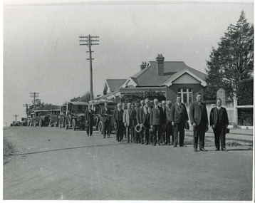
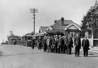
Photograph, 14th Dec. 1927 Funeral of Cr. F.T. Le Page JP Cheltenham, 14th Dec. 1927 Funeral of Cr. F.T. Le Page JP Cheltenham, 14th December 1927
... Le Page, leaving Cheltenham Church of Christ, Chesterville Road, for the old Cheltenham Cemetary. ...Le Page, leaving Cheltenham Church of Christ, Chesterville Road, for the old Cheltenham Cemetary. ...Le Page, leaving Cheltenham Church of Christ, Chesterville Road, for the old Cheltenham Cemetary. ...14th December 1927. The funeral of Cr. F.T. Le Page, leaving Cheltenham Church of Christ, Chesterville Road, for the old Cheltenham Cemetary. The undertakers were W.D. Rose & Son. Standing alongside the hearse is Mr Wally Rose. In front him is Mr Clarrie Judd, father of Mrs Clarice Whitehead. At the front of the procession are two Church of Christ Ministers. On the right is Mr Daniel Wakefield, who was minister at the time. On the left is Mr Mudge who was the previous minister. The man wearing collars are members of the Star of Moorabbin Order, of the Sons of Temperance Friendly Society. Others are elders from the church. Some of the names are: Mr George Brough, Mr Horace Brough, George Roberts, Tom Tilley, and Frank Martin. The house in the photograph was the home of Mr and Mrs Fred. Judd. The picket fence was at the front of the Church and the Cypress hedge on the right, was the home of Mr Chas. Fairbank, now the Church Manse grounds.Frank T Le Page arrived in Cheltenham, ( Two Acre Village) aged 3 with his father Nicholas Le Page , a tailor from Guernsey in the Channel Islands. Nicholas purchased one of Holloway's two-acre lots and established a market garden. Frank T Le Page worked on his father's market garden from age 14, then worked as a coachman and met Tommy Bent whilst employed at Brighton Grammar School. He bought land adjacent to his father's , built Daphne Cottage in 1876 and later established the Cheltenham Cream and Butter Factory. Frank T. Le Page was member of many community groups and was a Moorabbin Shire Councillor for 25 years serving a term as President. 'The Le Pages became one of the best known Moorabbin market gardening families, with a tradition of service to communal and civic affairs that is unmatched.' John Cribbin ' Moorabbin A Pictorial History 1862-1994 ' p3714th December 1927. The funeral of Cr. F.T. Le Page, leaving Cheltenham Church of Christ, Chesterville Road, for the old Cheltenham Cemetary. The undertakers were W.D. Rose & Son. Standing alongside the hearse is Mr Wally Rose. In front him is Mr Clarrie Judd, father of Mrs Clarice Whitehead. At the front of the procession are two Church of Christ Ministers. On the right is Mr Daniel Wakefield, who was minister at the time. On the left is Mr Mudge who was the previous minister. The man wearing collars are memebers of the Star of Moorabbin Order, of the Sons of Temperance Friendly Society. Others are elders from the church. Some of the names are: Mr George Brough, Mr Horace Brough, George Roberts, Tom Tilley, and Frank Martin. The house in the photograph was the home of Mr and Mrs Fred. Judd. The picket fence was at the front of the Church and the Cypress hedge on the right, was the home of Mr Chas. Fairbank, now the Church Manse grounds.Written as above signed D. Maynard 2/4/86funeral, 14th december 1927, cr. f.t. le page, cheltenham cemetery, mr george brough, mr horace brough, george roberts, tom tilley, frank martin., cheltenham church of christ, early settlers, market gardeners, rellgious rites, justice of the peace, star of moorabbin order of the sons of temperance friendly society, daphne cottage cheltenham victoria, cheltenham cream and butter factory ltd, tommy bent, moorabbin shire, le page everest , le page frank w. , le page frank t,, two acre village, dendy's special survay 1841, holloway josiah morris, -
 City of Kingston
Photograph - Black and white, Funeral procession of Francis Thomas Le Page, 1927
... Funeral procession of Francis Thomas Le Page leaving Church of Christ, Chesterville Road, Cheltenham. Minister of church lead procession followed by members of the Star of Moorabbin Order of the Sons of Temperance Friendly Society wearing broad collars. ...City of Kingston Parkdale Library 96 Parkers Road, Parkdale Parkdale Funeral procession of Francis Thomas Le Page leaving Church of Christ, Chesterville Road, Cheltenham. Minister of church lead procession followed by members of the Star of Moorabbin Order of the Sons of Temperance Friendly Society wearing broad collars. ...Funeral procession of Francis Thomas Le Page leaving Church of Christ, Chesterville Road, Cheltenham. Minister of church lead procession followed by members of the Star of Moorabbin Order of the Sons of Temperance Friendly Society wearing broad collars. F.T. Le Page was a councillor for 25 years and served as president of the Shire of Moorabbin in 1902/3. He died on 12 December 1927.Nicholas and Rachel (nee Addy) Le Page migrated from Geurnsey to Australia in 1852 with their young son Francis, who was less than a year old. They first lived in Prahran, setting up their own business and after about two years decided to move to Cheltenham and take up market gardening. The Le Page family has been associated with region ever since and have taken on many roles of prominence including local politics. Black and white image of a group of men, standing in two lines, all with hats off. They are standing in front of a line of cars. The first car in the line appears to have flowers on the roof which possibly indicates it is carrying the coffin in this funeral procession. Further information identifying the men and location of the procession can be found within the Collection's supplementary files. -
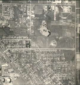
City of Kingston
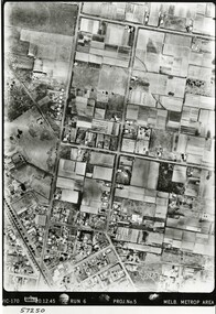
Photograph - Black and white, 5 January 1984
... The area depicted in the 1984 aerial view includes Eden Street and Edward Street, Cheltenham (top left), Weatherall Road and Reserve Road, Cheltenham/Beaumaris (top right), Turner Road and Chesterville Road, Moorabbin (bottom left), Nepean Highway (left section), Graham Road and Middleton Street, Highett (bottom right). ...The area depicted in the 1984 aerial view includes Eden Street and Edward Street, Cheltenham (top left), Weatherall Road and Reserve Road, Cheltenham/Beaumaris (top right), Turner Road and Chesterville Road, Moorabbin (bottom left), Nepean Highway (left section), Graham Road and Middleton Street, Highett (bottom right). ...Moorabbin, Cheltenham and Highett are suburbs in the City of Kingston with a diverse mix of development and zoning. The market gardens, farms and paddocks have gradually been sub-divided into housing and industrial estates and associated infrastructure such as schools and shopping facilities. The area includes many parks, reserves and golf courses.This aerial image covers a diverse section of the City of Kingston, taking in the suburbs of Cheltenham, Moorabbin, Beaumaris and Highett. By 1984, the market gardens of the district have been replaced by housing and factories. The Gas and Fuel state-of-the-art Scientific Services Department is visible on Nepean Highway Highett. The CSIRO Highett site can also be seen. Both sites have now been demolished and have undergone remediation. The Southland site is visible and yet to be redeveloped by Westfield. This image portrays the diversity of development in the City of Kingston with a mixture of green spaces, housing and commercial and industrial features.Aerial photograph of Cheltenham, Beaumaris, Moorabbin and Highett within the City of Kingston. The area depicted in the 1984 aerial view includes Eden Street and Edward Street, Cheltenham (top left), Weatherall Road and Reserve Road, Cheltenham/Beaumaris (top right), Turner Road and Chesterville Road, Moorabbin (bottom left), Nepean Highway (left section), Graham Road and Middleton Street, Highett (bottom right). A large section of this image includes Cheltenham Park and Victoria Golf Club.White text: 3831-219 Lens information [indecipherable] RINGWOOD M/S 7922-3 RUN 15 Clockface image 5,300' ASL VIC DLS© 5-1-84cheltenham, highett, industrialisation, urbanisation, moorabbin, beaumaris -
 City of Kingston
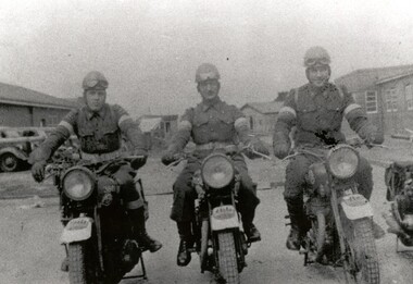
Photograph - Black and white, c.1942
... This image shows motorbike despatch riders who were tasked with transporting intercepted Japanese communications from the wartime wireless receiving station established in Chesterville Road, Moorabbin to Queens Road, St Kilda where the Directorate of Naval Communications and the code-breaking unit called FRUMEL (Fleet Radio Unit - Melbourne) were housed. ...A secret wartime wireless receiving station was established in March 1942 in Chesterville Road, Moorabbin. The station was established on requisitioned market garden properties, and soon housed WRAN (Women's Royal Australian Navy) personnel and up to 35 US Navy servicemen. ...This image shows motorbike despatch riders who were tasked with transporting intercepted Japanese communications from the wartime wireless receiving station established in Chesterville Road, Moorabbin to Queens Road, St Kilda where the Directorate of Naval Communications and the code-breaking unit called FRUMEL (Fleet Radio Unit - Melbourne) were housed. The despatch riders would travel every two hours, all day and night. The wireless receiving station was established in Moorabbin because it was considered an area free of significant electrical interference and was not too far afield from the Melbourne headquarters in Queens Road. Moorabbin was originally established as a rural market gardening community.A secret wartime wireless receiving station was established in March 1942 in Chesterville Road, Moorabbin. The station was established on requisitioned market garden properties, and soon housed WRAN (Women's Royal Australian Navy) personnel and up to 35 US Navy servicemen. The Navy personnel intercepted Japanese coded communications and then despatched these by motorbike riders to Queens Road, St Kilda where the Directorate of Naval Communications and the code-breaking unit called FRUMEL (Fleet Radio Unit - Melbourne) were housed. The information intercepted by the wireless receiving station helped shape the Allied response to Japan's advances in the Pacific. Declassified defence records show that this unprepossessing station handled some of World War II's most sensitive secrets, and the despatch riders were a familiar sight in the Moorabbin area, though few were aware of their purpose. Black and white image of three men in uniform sitting astride three motorcycles in front of cars and buildings. The rider on the right is Jack Barker a local resident. Handwritten in red ink: A 602 / 90% Handwritten in blue ink: SW / 950301111 Handwritten in grey pencil: A 34 CHAP 6 / Spy basemoorabbin, despatch riders, wireless receiving station, world war ii, frumel (fleet radio unit - melbourne) -
 Marysville & District Historical Society
Photograph (item) - Black and white photograph, Unknown
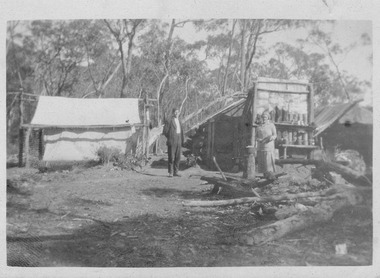
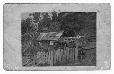
... ...chesterville...William Edward Chester discovered the Golden Secret gold vein which became part of the Golden Bower Mine at Chesterville near Donovans Creek on the Cumberland goldfield which he mined with George Locke until the late 1930s. golden bower gold mine cumberland valley victoria quartz reef mining water-powered battery william edward chester george locke chesterville donovan's creek cumberland goldfield An early black and white photograph taken at the Golden Bower in the Cumberland Valley in Victoria. ...An early black and white photograph taken at the Golden Bower in the Cumberland Valley in Victoria.An early black and white photograph taken at the Golden Bower Mine in the Cumberland Valley in Victoria. The Golden Bower gold mine was a quartz reef mine. William Edward Chester discovered the Golden Secret gold vein which became part of the Golden Bower Mine at Chesterville near Donovans Creek on the Cumberland goldfield which he mined with George Locke until the late 1930s. golden bower gold mine, cumberland valley, victoria, quartz reef mining, water-powered battery, william edward chester, george locke, chesterville, donovan's creek, cumberland goldfield -
 Marysville & District Historical Society
Photograph (item) - Black and white photograph, Unknown
... ...chesterville...William Edward Chester discovered the Golden Secret gold vein which became part of the Golden Bower Mine at Chesterville near Donovans Creek on the Cumberland goldfield which he mined with George Locke until the late 1930s. golden bower gold mine cumberland valley victoria quartz reef mining water-powered battery william edward chester george locke chesterville donovan's creek cumberland goldfield An early black and white photograph of the blacksmith's forge at the Golden Bower mine in the Cumberland Valley in Victoria. ...An early black and white photograph of the blacksmith's forge at the Golden Bower mine in the Cumberland Valley in Victoria.An early black and white photograph taken at the Golden Bower Mine in the Cumberland Valley in Victoria. The Golden Bower gold mine was a quartz reef mine. William Edward Chester discovered the Golden Secret gold vein which became part of the Golden Bower Mine at Chesterville near Donovans Creek on the Cumberland goldfield which he mined with George Locke until the late 1930s. golden bower gold mine, cumberland valley, victoria, quartz reef mining, water-powered battery, william edward chester, george locke, chesterville, donovan's creek, cumberland goldfield -
 Marysville & District Historical Society
Photograph (item) - Black and white photograph, Unknown
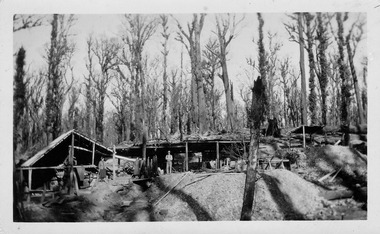
... ...chesterville...William Edward Chester discovered the Golden Secret gold vein which became part of the Golden Bower Mine at Chesterville near Donovans Creek on the Cumberland goldfield which he mined with George Locke until the late 1930s. golden bower gold mine cumberland valley victoria quartz reef mining water-powered battery william edward chester george locke chesterville donovan's creek cumberland goldfield An early black and white photograph of the Golden Bower mine in the Cumberland Valley in Victoria. ...An early black and white photograph of the Golden Bower mine in the Cumberland Valley in Victoria.An early black and white photograph taken at the Golden Bower Mine in the Cumberland Valley in Victoria. The Golden Bower gold mine was a quartz reef mine. William Edward Chester discovered the Golden Secret gold vein which became part of the Golden Bower Mine at Chesterville near Donovans Creek on the Cumberland goldfield which he mined with George Locke until the late 1930s. golden bower gold mine, cumberland valley, victoria, quartz reef mining, water-powered battery, william edward chester, george locke, chesterville, donovan's creek, cumberland goldfield -
 Marysville & District Historical Society
Photograph (item) - Black and white photograph, Unknown
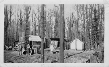
... ...chesterville...William Edward Chester discovered the Golden Secret gold vein which became part of the Golden Bower Mine at Chesterville near Donovans Creek on the Cumberland goldfield which he mined with George Locke until the late 1930s. golden bower gold mine cumberland valley victoria quartz reef mining water-powered battery william edward chester george locke chesterville donovan's creek cumberland goldfield An early black and white photograph of the Golden Bower mine camp in the Cumberland Valley in Victoria. ...An early black and white photograph of the Golden Bower mine camp in the Cumberland Valley in Victoria.An early black and white photograph taken at the Golden Bower Mine in the Cumberland Valley in Victoria. The Golden Bower gold mine was a quartz reef mine. William Edward Chester discovered the Golden Secret gold vein which became part of the Golden Bower Mine at Chesterville near Donovans Creek on the Cumberland goldfield which he mined with George Locke until the late 1930s. golden bower gold mine, cumberland valley, victoria, quartz reef mining, water-powered battery, william edward chester, george locke, chesterville, donovan's creek, cumberland goldfield -
 Marysville & District Historical Society
Photograph (item) - Black and white photograph, Unknown
... ...chesterville...William Edward Chester discovered the Golden Secret gold vein which became part of the Golden Bower Mine at Chesterville near Donovans Creek on the Cumberland goldfield which he mined with George Locke until the late 1930s. golden bower gold mine cumberland valley victoria quartz reef mining water-powered battery william edward chester george locke chesterville donovan's creek cumberland goldfield An early black and white photograph taken at the Golden Bower Mine Camp in the Cumberland Valley in Victoria. ...An early black and white photograph taken at the Golden Bower Mine Camp in the Cumberland Valley in Victoria.An early black and white photograph taken at the Golden Bower Mine in the Cumberland Valley in Victoria. The Golden Bower gold mine was a quartz reef mine. William Edward Chester discovered the Golden Secret gold vein which became part of the Golden Bower Mine at Chesterville near Donovans Creek on the Cumberland goldfield which he mined with George Locke until the late 1930s. golden bower gold mine, cumberland valley, victoria, quartz reef mining, water-powered battery, william edward chester, george locke, chesterville, donovan's creek, cumberland goldfield -
 Marysville & District Historical Society
Photograph (item) - Black and white photograph, Unknown
... ...chesterville...William Edward Chester discovered the Golden Secret gold vein which became part of the Golden Bower Mine at Chesterville near Donovans Creek on the Cumberland goldfield which he mined with George Locke until the late 1930s. golden bower gold mine cumberland valley victoria quartz reef mining water-powered battery william edward chester george locke chesterville donovan's creek cumberland goldfield An early black and white photograph taken at the Golden Bower Mine in the Cumberland Valley in Victoria. ...An early black and white photograph taken at the Golden Bower Mine in the Cumberland Valley in Victoria.An early black and white photograph taken at the Golden Bower Mine in the Cumberland Valley in Victoria. The Golden Bower gold mine was a quartz reef mine. William Edward Chester discovered the Golden Secret gold vein which became part of the Golden Bower Mine at Chesterville near Donovans Creek on the Cumberland goldfield which he mined with George Locke until the late 1930s. golden bower gold mine, cumberland valley, victoria, quartz reef mining, water-powered battery, william edward chester, george locke, chesterville, donovan's creek, cumberland goldfield -
 Marysville & District Historical Society
Postcard (item) - Black and white postcard, Unknown
... ...chesterville...William Edward Chester discovered the Golden Secret gold vein which became part of the Golden Bower Mine at Chesterville near Donovans Creek on the Cumberland goldfield which he mined with George Locke until the late 1930s. golden bower gold mine cumberland valley victoria quartz reef mining water-powered battery william edward chester george locke chesterville donovan's creek cumberland goldfield POST CARD CORRESPONDENCE. ...An early black and white photograph taken at the Golden Bower Mine Camp in the Cumberland Valley in Victoria.An early black and white photograph taken at the Golden Bower Mine Camp in the Cumberland Valley in Victoria. The Golden Bower gold mine was a quartz reef mine. William Edward Chester discovered the Golden Secret gold vein which became part of the Golden Bower Mine at Chesterville near Donovans Creek on the Cumberland goldfield which he mined with George Locke until the late 1930s. POST CARD CORRESPONDENCE. ADDRESS ONLY. KODAK/ AUSTRALIA 30/06/10 Rose Hill/ Fitzwilliam Street/ Kew Should have written/ to you months ago about the/ photos I took at Easter./ Sorry to say the one of the little/ girls was no good I expect/ you will recognise both these/ places/ K McDowell Mrs Fletcher/ Golden Bower Mine/ Via Marysville J Mahoneygolden bower gold mine, cumberland valley, victoria, quartz reef mining, water-powered battery, william edward chester, george locke, chesterville, donovan's creek, cumberland goldfield -
 City of Kingston
Photograph - Black and white, 20 December 1945
... The image includes Chesterville Road, the future site of Turner Road pool (now Waves) and Highett Reserve, (top left), Jellicoe Street, Argus Street, Bernard Street, Wilson Street, the Methodist Children Homes (now Southland), McIvor Street, Goulburn Street, Nepean Highway, Jamieson Street and Barker Street (bottom left), market gardens and paddocks. ...The Le Page family lived in Cheltenham since 1854 when Nicholas Le Page, a tailor from the Channel Island of Guernsey, bought two acres of land on Chesterville Road near Bernard Street to establish a market garden. ...Cheltenham is a suburb in the City of Kingston that was originally established as a rural market gardening community. The area is bordered by Highett, Mentone and Heatherton. The market gardens, farms and paddocks have gradually been sub-divided into housing and industrial estates. The Southland shopping centre is a major feature of the area.Cheltenham was established as a rural market gardening community. The Le Page family lived in Cheltenham since 1854 when Nicholas Le Page, a tailor from the Channel Island of Guernsey, bought two acres of land on Chesterville Road near Bernard Street to establish a market garden. Over the years the Le Pages purchased more land in the area. In 1875-76 Nicholas' son Frank and his wife Mary built 'Daphne Cottage' near the corner of Bernard and Wilson Streets. n the 1940s Frank's son, Everest Le Page, bought five more lots of land in Chesterville Road from the Tuck family. The Le Pages grazed horses, ponies and cows on this land, and grew pumpkins, carrots, parsnips, onions, potatoes and cabbages. Many buildings and locations within in Cheltenham commemorate the Le Page family's contribution to the Cheltenham community.Aerial photograph taken in 1945 of the Cheltenham district within the City of Kingston. The image includes Chesterville Road, the future site of Turner Road pool (now Waves) and Highett Reserve, (top left), Jellicoe Street, Argus Street, Bernard Street, Wilson Street, the Methodist Children Homes (now Southland), McIvor Street, Goulburn Street, Nepean Highway, Jamieson Street and Barker Street (bottom left), market gardens and paddocks. In the top centre of the image, "Daphne Cottage", the home of Frank T. Le Page is visible on the corner of Bernard and Wilson Streets. Much of the land depicted in this image was owned by the Le Page family. This image is possibly from the collection of aerial photographs commissioned by the Department of Crown Lands and Survey and taken by Adastra Airways.Black and white ink: 57250 White print: VIC-170 57250 20.12.45 Run 6 PROJ. No. 5 MELB. METROP AREA Black type 10200 FTS 30' LENS 20.12.45cheltenham, market gardens, industry, le page family -
 Marysville & District Historical Society
Postcard (item) - Black and white postcard, Unknown
... ...chesterville...William Edward Chester discovered the Golden Secret gold vein which became part of the Golden Bower Mine at Chesterville near Donovans Creek on the Cumberland goldfield which he mined with George Locke until the late 1930s. golden bower gold mine cumberland valley victoria quartz reef mining water-powered battery william edward chester george locke chesterville donovan's creek cumberland goldfield postcard souvenir POST CARD EMPIRE FOR CORRESPONDENCE FOR ADDRESS ONLY STAMP An early black and white photograph of men clearing the forest at the Golden Bower Mine in the Cumberland Valley in Victoria. ...An early black and white photograph taken at the Golden Bower Mine in the Cumberland Valley in Victoria.An early black and white photograph taken at the Golden Bower Mine in the Cumberland Valley in Victoria. The Golden Bower gold mine was a quartz reef mine. William Edward Chester discovered the Golden Secret gold vein which became part of the Golden Bower Mine at Chesterville near Donovans Creek on the Cumberland goldfield which he mined with George Locke until the late 1930s. POST CARD EMPIRE FOR CORRESPONDENCE FOR ADDRESS ONLY STAMPgolden bower gold mine, cumberland valley, victoria, quartz reef mining, water-powered battery, william edward chester, george locke, chesterville, donovan's creek, cumberland goldfield, postcard, souvenir -
Marysville & District Historical Society
Document (item) - Gold Mine Prospectus, Messrs Bruce & Robinson, Prospectus-Chester & Locke's Golden Secret Gold Mining Company, 1899
... ...chesterville...William Edward Chester discovered the Golden Secret gold vein which became part of the Golden Bower Mine at Chesterville near Donovans Creek on the Cumberland goldfield which he mined with George Locke until the late 1930s. share prospectus chester & locke's golden secret mining company marysville victoria yarra track upper yarra district david newell j.g. aikman w.j. mountain andrew barrie gold mining messrs w.p. jones and co. william chester george locke chesterville FOR PRIVATE CIRCULATION A copy of the prospectus for the Chester & Locke's Golden Secret Mining Company near Marysville in Victoria. ...A copy of the prospectus for the Chester & Locke's Golden Secret Mining Company near Marysville in Victoria.A copy of the prospectus for the Chester & Locke's Golden Secret Mining Company near Marysville in Victoria. The Golden Bower gold mine was a quartz reef mine. William Edward Chester discovered the Golden Secret gold vein which became part of the Golden Bower Mine at Chesterville near Donovans Creek on the Cumberland goldfield which he mined with George Locke until the late 1930s. FOR PRIVATE CIRCULATIONshare prospectus, chester & locke's golden secret mining company, marysville, victoria, yarra track, upper yarra district, david newell, j.g. aikman, w.j. mountain, andrew barrie, gold mining, messrs w.p. jones and co., william chester, george locke, chesterville -
 City of Kingston
Negative - 35mm, black and white, Percy Fairlam, c. 1910
... Image 1a and 1b - Church of Christ, located in Chesterville Road, Cheltenham. Images 2a and 2b - Pioneer Presbyterian Church, Scots Church, located in Charman Road, Cheltenham Images 3a and 3b - Shopping strip located on Charman Road, Cheltenham, c.1918 Images 4a and 4b - A cricket team, located in Cheltenham Images 5a and 5b - Cheltenham Cricket Team, photographed outside St Matthew's Church. ...City of Kingston Parkdale Library 96 Parkers Road, Parkdale Parkdale Image 1a and 1b - Church of Christ, located in Chesterville Road, Cheltenham. Images 2a and 2b - Pioneer Presbyterian Church, Scots Church, located in Charman Road, Cheltenham Images 3a and 3b - Shopping strip located on Charman Road, Cheltenham, c.1918 Images 4a and 4b - A cricket team, located in Cheltenham Images 5a and 5b - Cheltenham Cricket Team, photographed outside St Matthew's Church. ...Image 1a and 1b - Church of Christ, located in Chesterville Road, Cheltenham. Images 2a and 2b - Pioneer Presbyterian Church, Scots Church, located in Charman Road, Cheltenham Images 3a and 3b - Shopping strip located on Charman Road, Cheltenham, c.1918 Images 4a and 4b - A cricket team, located in Cheltenham Images 5a and 5b - Cheltenham Cricket Team, photographed outside St Matthew's Church. Back row: E. McSwain, R. Woff, S. Cullen, F. Bodley, T. Chandler, C. Warne, A. Organ, J Monk. Middle Row: C. Roberts, A. Hewett, S. Chandler, F. Chandler, A. Chandler. Front Row: A. Beulke, F. Groves Images 6a and 6b - Cheltenham Rifle Club Committee Opening Day of the new Butts. Back row: C Irwin, E. W. Proudman (Chemist), F T LePage, Centre: W Lamb Smith (Captain), E T Penny, G. Stayner, One unknown gentleman, Front: John Butler, city inspector, and E C Rippon (Manager of the Cheltenham and District Co-operative). A strip of 35mm black and white negative film of six photographs. rifle club, cricket, cheltenham cricket club, charman rd, church, cricket club, shopping strip, horse, cow, sport, team, cars -
Marysville & District Historical Society
Document (item) - Research Document, Judith Vimpani, George Ernest Locke 1860-1941, 2020
... ...chesterville...When George passed away at the age of 81 years he had not visited Marysville for over 14 years. george ernest locke gold miner gold mining yarra track william chester golden bower mine cumberland goldfield silver bower mine chesterville marysville victoria jackie lewis baron somers big tree picea sitchensis exotic box hill cemetery john edward locke annie caroline locke hermit of the cumberland valley An account of the life of George Ernest Locke who was a gold miner on the Yarra Track near Marysville in Victoria. ...An account of the life of George Ernest Locke who was a gold miner on the Yarra Track near Marysville in Victoria.An account of the life of George Ernest Locke who was a gold miner on the Yarra Track near Marysville in Victoria. George was a well-educated young man and had some success prospecting in the Cumberland area before partnering with William Chester with whom he opened the Golden Bower gold mine in 1896. George and William then discovered a second reef which they named the Silver Bower mine. George lived in a log cabin in the Cumberland reserve and was known to be a loner. He was clever with his money and chose not to have a bank account in Marysville, where everyone would learn about his financial status. He banked at the ES&A in Fitzroy and at the time of his death in 1941 he had accumulated the princely sum of three hundred and sixty pounds. George Locke was known as "the Hermit of Cumberland Valley" and lived in his humpy until his last few days during which he moved into a Forest Commission's patrol hut because his old humpy had started to fall to pieces. When George passed away at the age of 81 years he had not visited Marysville for over 14 years. george ernest locke, gold miner, gold mining, yarra track, william chester, golden bower mine, cumberland goldfield, silver bower mine, chesterville, marysville, victoria, jackie lewis, baron somers, big tree, picea sitchensis exotic, box hill cemetery, john edward locke, annie caroline locke, hermit of the cumberland valley -
Marysville & District Historical Society
Document (item) - Research Document, Judith Vimpani, Gold Mining at the Cumberland Goldfields, 03-2022
... ...chesterville...A research document covering gold mining at the Cumberland goldfields in Victoria. gold mining cumberland goldfields cambarville donovan's creek bear's creek walsh's creek cumberland creek golden bower gold-mining company a1 gold-mining company yarra track jw curtis kohler william edward chester golden secret gold vein golden bower mine chesterville andrew kirwan walker's hotel george locke marysville james fahie alma kathleen barry john edward weatherland william forbes wilson A research document covering gold mining at the Cumberland goldfields in Victoria. ...A research document covering gold mining at the Cumberland goldfields in Victoria.A research document covering gold mining at the Cumberland goldfields in Victoria.gold mining, cumberland goldfields, cambarville, donovan's creek, bear's creek, walsh's creek, cumberland creek, golden bower gold-mining company, a1 gold-mining company, yarra track, jw curtis, kohler, william edward chester, golden secret gold vein, golden bower mine, chesterville, andrew kirwan, walker's hotel, george locke, marysville, james fahie, alma kathleen barry, john edward weatherland, william forbes wilson -
 Flagstaff Hill Maritime Museum and Village
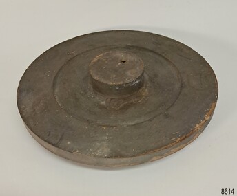
Equipment - Pattern, Briggs Brass Foundry, 1912-1972
... The firm relocated to Chesterville Rd, Moorabbin and Cyril went into partnership with Frank Lee. ...The firm relocated to Chesterville Rd, Moorabbin and Cyril went into partnership with Frank Lee. ...The wooden pattern forms part of a larger collection; some of them were secured within a durable wooden crate. The cast pattern was an essential tool at Briggs Brass Foundry, specifically designed for creating sand casts. Sand casting is a time-honoured technique, with a history exceeding 2,000 years. The handcrafted nature of this process produces brass and copper alloy items particularly suitable for maritime applications. Typical products include bells, boat hooks, cowls, propellers, handles, lids, rowlocks, hooks, letters, bolts, rail holders, brackets, deck plates, flanges, rudder guides, portholes and covers. The distinctive bronze mixture used at Briggs’ Foundry is copper based. It is composed of local ingots of copper, tin, zinc and lead, blended in precisely measured quantities. The resulting alloy is non-ferrous, known for its exceptional durability and longevity. HISTORY OF BRIGGS MARINE: The Briggs Brass Foundry, trading as Briggs & Son Foundry, was established in 1912 by Herbert Harrison Briggs (1863-1931) with his son George Edward Briggs. In 1922, the youngest son, Cyril Falkiner McKinnon Briggs, joined the foundry. After Herbert died in 1931, his sons George and Cyril ran the foundry. The business became known as Briggs Marine Foundry, the “non-ferrous founders” and “bell specialists”. The foundry products were made using the traditional sand-casting method, which is now over two thousand years old and is becoming a dying art. The foundry operated at 70 Wellington St, Collingwood, and specialised in casting ship bells and other marine equipment and fittings. It also made decorative items such as miniature ship propellers. The great-granddaughter of Herbert Briggs inherited a Briggs brass bell, similar to one at Flagstaff Hill Maritime Village. In 1965, Cyril was the only remaining family member involved in Briggs Marine Products. The firm relocated to Chesterville Rd, Moorabbin and Cyril went into partnership with Frank Lee. In the same year, the firm exhibited its products at the 1965 Boat Show. When Cyril passed away in 1967, Frank took over the business with two new partners. After Frank Lee died in 1971, the foundry was run by his son and daughter-in-law, Les and Eva Lee. Briggs Marine still exists today, but the Briggs family is no longer involved. Briggs Foundry had a community-minded retail branch in Warrnambool, selling cast boat fittings and equipment to fishermen and others in the regional marine industry. The branch closed in 1972. In Flagstaff Hill’s formative years, 1972-1975, many Briggs Marine brassware products were generously donated from its Melbourne foundry, along with casting patterns, tools, machinery and a cupboard. EXHIBITION and LEGACY: The donated items were displayed in a simulated Brass Foundry within the Village, where visitors could view them and gain insight into the foundering and metalwork trades that supported maritime industries, including shipwrights and boatbuilders. The castings produced at the foundry were also vital for farmers, manufacturers and other local industries. This exhibit was part of a broader showcase of working crafts, trades and services typical of a Maritime town. The display was available to the public from the completion of the building in 1986 until 1994, when the space was repurposed. It is believed that Briggs Marine’s family members gave personal assistance in setting up the displays in the original village shops, particularly the ‘Brass Foundry’ building. A notable feature of the Village Brass Foundry was the historic Cornish chimney, presented as a working model. This chimney visually demonstrated the process of smelting metal in furnaces and pouring it into sand moulds. Constructed from specially curved bricks, the chimney now stands at about two-thirds of its original height, having been relocated from the Grassmere Cheese factory. The hand-cast sand patterns hold considerable significance due to their association with Briggs Brass Founders, a firm established in the early 20th century and widely recognised for its expertise in producing, repairing, and restoring ship bells and marine equipment. Known for their specialisation in non-ferrous metal casting, Briggs Brass Founders supplied high-quality fittings and equipment for maritime use. The company extended its operations by opening a branch in Warrnambool, where it actively supported the local community. The foundry’s ability to cast essential products was important to local and regional industries, like fishing, farming, manufacturing and commercial businesses. Through its presence, its reputation was reinforced as both a skilled manufacturer and a community-minded enterprise. The foundry is notably associated with the Schomberg Bell at Flagstaff Hill, having restored this small, historic bell to its original condition. The Schomberg Bell is a fine example from a luxury migrant vessel dating back to the mid-19th century, reflecting the craftsmanship and heritage preserved by Briggs Brass Foundry. Pattern; round wooden shape with a wide concave centre and a round flat handle in the middle, painted dark brown. The underside has a large wooden disc added to the centre. The pattern is part of a set of foundry patterns from Briggs Brass Foundry.flagstaff hill, flagstaff hill maritime museum and village, warrnambool, maritime museum, maritime village, great ocean road, shipwreck coast, briggs' bronze, traditional method, trade, sand cast, cast, brass alloy, copper alloy, pattern, mould, foundry, brass foundry, metal foundry, casting, sand mould, sand casting, marine equipment, marine tools, marine fittings, copper tin zinc lead, non-ferrous, non-corrosive, brassware, metalware, foundering, metalwork, maritime, bell founders, ship chandlers, marine products, biggs, briggs family, herbert harrison briggs, h h briggs, george edward briggs, cyril falkiner mckinnon briggs, cyril briggs, briggs & son brass foundry, h h briggs & sons foundry, briggs marine, alliance casting & engineering solutions, grassmere cheese factory, cornish chimney, curved bricks, collingwood, moorabbin, collingwood foundry, moorabbin foundry, 1912, briggs, briggs brass foundry, briggs marine foundry, briggs marine products, frank lee, les lee, eva lee, briggs marine warrnambool, non-ferrous founders, bell specialists, ship bell specialists, founders, metalworking, traditional sand casting, casting pattern, foundry pattern -
 Flagstaff Hill Maritime Museum and Village
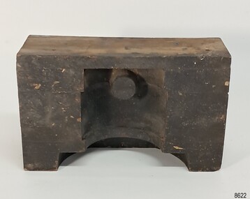
Equipment - Pattern, Briggs Brass Foundry, 1912-1972
... The firm relocated to Chesterville Rd, Moorabbin and Cyril went into partnership with Frank Lee. ...The firm relocated to Chesterville Rd, Moorabbin and Cyril went into partnership with Frank Lee. ...The wooden pattern forms part of a larger collection; some of them were secured within a durable wooden crate. The cast pattern was an essential tool at Briggs Brass Foundry, specifically designed for creating sand casts. Sand casting is a time-honoured technique, with a history exceeding 2,000 years. The handcrafted nature of this process produces brass and copper alloy items particularly suitable for maritime applications. Typical products include bells, boat hooks, cowls, propellers, handles, lids, rowlocks, hooks, letters, bolts, rail holders, brackets, deck plates, flanges, rudder guides, portholes and covers. The distinctive bronze mixture used at Briggs’ Foundry is copper based. It is composed of local ingots of copper, tin, zinc and lead, blended in precisely measured quantities. The resulting alloy is non-ferrous, known for its exceptional durability and longevity. HISTORY OF BRIGGS MARINE: The Briggs Brass Foundry, trading as Briggs & Son Foundry, was established in 1912 by Herbert Harrison Briggs (1863-1931) with his son George Edward Briggs. In 1922, the youngest son, Cyril Falkiner McKinnon Briggs, joined the foundry. After Herbert died in 1931, his sons George and Cyril ran the foundry. The business became known as Briggs Marine Foundry, the “non-ferrous founders” and “bell specialists”. The foundry products were made using the traditional sand-casting method, which is now over two thousand years old and is becoming a dying art. The foundry operated at 70 Wellington St, Collingwood, and specialised in casting ship bells and other marine equipment and fittings. It also made decorative items such as miniature ship propellers. The great-granddaughter of Herbert Briggs inherited a Briggs brass bell, similar to one at Flagstaff Hill Maritime Village. In 1965, Cyril was the only remaining family member involved in Briggs Marine Products. The firm relocated to Chesterville Rd, Moorabbin and Cyril went into partnership with Frank Lee. In the same year, the firm exhibited its products at the 1965 Boat Show. When Cyril passed away in 1967, Frank took over the business with two new partners. After Frank Lee died in 1971, the foundry was run by his son and daughter-in-law, Les and Eva Lee. Briggs Marine still exists today, but the Briggs family is no longer involved. Briggs Foundry had a community-minded retail branch in Warrnambool, selling cast boat fittings and equipment to fishermen and others in the regional marine industry. The branch closed in 1972. In Flagstaff Hill’s formative years, 1972-1975, many Briggs Marine brassware products were generously donated from its Melbourne foundry, along with casting patterns, tools, machinery and a cupboard. EXHIBITION and LEGACY: The donated items were displayed in a simulated Brass Foundry within the Village, where visitors could view them and gain insight into the foundering and metalwork trades that supported maritime industries, including shipwrights and boatbuilders. The castings produced at the foundry were also vital for farmers, manufacturers and other local industries. This exhibit was part of a broader showcase of working crafts, trades and services typical of a Maritime town. The display was available to the public from the completion of the building in 1986 until 1994, when the space was repurposed. It is believed that Briggs Marine’s family members gave personal assistance in setting up the displays in the original village shops, particularly the ‘Brass Foundry’ building. A notable feature of the Village Brass Foundry was the historic Cornish chimney, presented as a working model. This chimney visually demonstrated the process of smelting metal in furnaces and pouring it into sand moulds. Constructed from specially curved bricks, the chimney now stands at about two-thirds of its original height, having been relocated from the Grassmere Cheese factory. The hand-cast sand patterns hold considerable significance due to their association with Briggs Brass Founders, a firm established in the early 20th century and widely recognised for its expertise in producing, repairing, and restoring ship bells and marine equipment. Known for their specialisation in non-ferrous metal casting, Briggs Brass Founders supplied high-quality fittings and equipment for maritime use. The company extended its operations by opening a branch in Warrnambool, where it actively supported the local community. The foundry’s ability to cast essential products was important to local and regional industries, like fishing, farming, manufacturing and commercial businesses. Through its presence, its reputation was reinforced as both a skilled manufacturer and a community-minded enterprise. The foundry is notably associated with the Schomberg Bell at Flagstaff Hill, having restored this small, historic bell to its original condition. The Schomberg Bell is a fine example from a luxury migrant vessel dating back to the mid-19th century, reflecting the craftsmanship and heritage preserved by Briggs Brass Foundry. Pattern; rectangular wooden block made from laminated sections of wood painted black. A half-cylinder shape was carved into the long side, and a dowel shape was placed at the lower side. The pattern is part of a set of foundry patterns from Briggs Brass Foundry.flagstaff hill, flagstaff hill maritime museum and village, warrnambool, maritime museum, maritime village, great ocean road, shipwreck coast, briggs' bronze, traditional method, trade, sand cast, cast, brass alloy, copper alloy, pattern, mould, foundry, brass foundry, metal foundry, casting, sand mould, sand casting, marine equipment, marine tools, marine fittings, copper tin zinc lead, non-ferrous, non-corrosive, brassware, metalware, foundering, metalwork, maritime, bell founders, ship chandlers, marine products, biggs, briggs family, herbert harrison briggs, h h briggs, george edward briggs, cyril falkiner mckinnon briggs, cyril briggs, briggs & son brass foundry, h h briggs & sons foundry, briggs marine, alliance casting & engineering solutions, grassmere cheese factory, cornish chimney, curved bricks, collingwood, moorabbin, collingwood foundry, moorabbin foundry, 1912, briggs, briggs brass foundry, briggs marine foundry, briggs marine products, frank lee, les lee, eva lee, briggs marine warrnambool, non-ferrous founders, bell specialists, ship bell specialists, founders, metalworking, traditional sand casting, casting pattern, foundry pattern