Showing 35 items matching "chipperfields"
-
 Kew Historical Society Inc
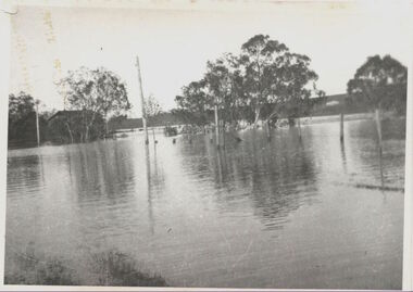
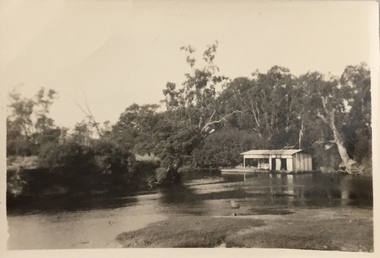
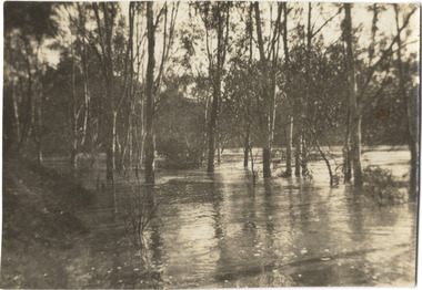
Photograph, Willsmere Bridge, 1934
... ...chipperfields...They included Chipperfield’s ‘Moorings’ and floating pontoon. ...Willsmere Bridge. Chipperfields. 1934 flood...They included Chipperfield’s ‘Moorings’ and floating pontoon. ...Several boathouses were built in Kew and Fairfield in the late 19th and early 20th centuries. They included Chipperfield’s ‘Moorings’ and floating pontoon. The substantial two-storey house was named the Moorings, and incorporated an upper storey residence. The Moorings was almost washed away in the 1916 floods, and in 1934 almost totally submerged when the Yarra River rose 26 feet in 14 hours. Following the 1934 flood, the house was restored. The floating pontoon, sometimes referred to as a ‘kiosk’ or ‘canteen’, was used to store canoes. Both were removed in 1972 for the construction of the Eastern Freeway.This work forms part of the collection assembled by the historian Dorothy Rogers, that was donated to the Kew Historical Society by her son John Rogers in 2015. The manuscripts, photographs, maps, and documents were sourced by her from both family and local collections or produced as references for her print publications. Many were directly used by Rogers in writing ‘Lovely Old Homes of Kew’ (1961) and 'A History of Kew' (1973), or the numerous articles on local history that she produced for suburban newspapers. Most of the photographs in the collection include detailed annotations in her hand. The Rogers Collection provides a comprehensive insight into the working habits of a historian in the 1960s and 1970s. Together it forms the largest privately-donated collection within the archives of the Kew Historical Society.A view of flooded areas in North Kew in the flood of 1934.Willsmere Bridge. Chipperfields. 1934 floodwillsmere, flood, yarra flood, chipperfields, chipperfields boathouse, north kew -
 Kew Historical Society Inc
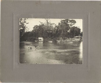
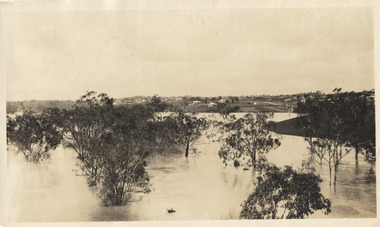
Photograph, Chipperfield's Boat House & Floating Pontoon, c.1939
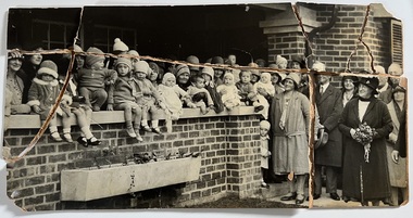
... They included Chipperfield’s ‘Moorings’ and floating pontoon. ...Chipperfield's Floating Canteen (also known as the pontoon) on the Yarra River. at North Kew The children wading in the river are believed to be the three sons of Dorothy Rogers...."Chipperfield's Floating Canteen & house in background. ...They included Chipperfield’s ‘Moorings’ and floating pontoon. ...Several boathouses were built in Kew and Fairfield in the late 19th and early 20th centuries. They included Chipperfield’s ‘Moorings’ and floating pontoon. The substantial two-storey house was named the Moorings, and incorporated an upper storey residence. The Moorings was almost washed away in the 1916 floods, and in 1934 almost totally submerged when the Yarra River rose 26 feet in 14 hours. Following the 1934 flood, the house was restored. The floating pontoon, sometimes referred to as a ‘kiosk’ or ‘canteen’, was used to store canoes. Both were removed in 1972 for the construction of the Eastern Freeway.This work forms part of the collection assembled by the historian Dorothy Rogers, that was donated to the Kew Historical Society by her son John Rogers in 2015. The manuscripts, photographs, maps, and documents were sourced by her from both family and local collections or produced as references for her print publications. Many were directly used by Rogers in writing ‘Lovely Old Homes of Kew’ (1961) and 'A History of Kew' (1973), or the numerous articles on local history that she produced for suburban newspapers. Most of the photographs in the collection include detailed annotations in her hand. The Rogers Collection provides a comprehensive insight into the working habits of a historian in the 1960s and 1970s. Together it forms the largest privately-donated collection within the archives of the Kew Historical Society.Chipperfield's Floating Canteen (also known as the pontoon) on the Yarra River. at North Kew The children wading in the river are believed to be the three sons of Dorothy Rogers."Chipperfield's Floating Canteen & house in background. At extreme right - observe channel where Connors Creek flows in."chipperfield's boat house, river yarra, dorothy rogers, floods 1916, 1934 -
 Kew Historical Society Inc
Photograph - Flooding of the Yarra River in North Kew, 1934
... Small sepia snapshot of the devastation caused by the 1934 flood.The photo was taken in the vicinity of Kellett Grove, North Kew and includes the roof of Chipperfield's Boathouse as well as other local houses....Verso: THIS IS CHIPPERFIELD'S BOAT SHEDS & COES & WILLIAMS TAKEN FROM OUR STREET / 1934...Prior to urban development, the area since European settlement and the first land sales in the district in the 1840s, had been used for dairy farming. . yarra river -- north kew floods -- yarra valley floods -- north kew floods -- 1934 natural disasters -- kew chipperfields boathouse Verso: THIS IS CHIPPERFIELD'S BOAT SHEDS & COES & WILLIAMS TAKEN FROM OUR STREET / 1934 Small sepia snapshot of the devastation caused by the 1934 flood.The photo was taken in the vicinity of Kellett Grove, North Kew and includes the roof of Chipperfield's Boathouse as well as other local houses. ...North Kew, now divided between Kew and Kew East, bordered the Yarra River. As such, it was a region subject to flooding in the Yarra Valley. Development beyond this point (ie Kellett Grove) was limited by the City of Kew's planning regulations. Prior to urban development, the area since European settlement and the first land sales in the district in the 1840s, had been used for dairy farming. .Small sepia snapshot of the devastation caused by the 1934 flood.The photo was taken in the vicinity of Kellett Grove, North Kew and includes the roof of Chipperfield's Boathouse as well as other local houses.Verso: THIS IS CHIPPERFIELD'S BOAT SHEDS & COES & WILLIAMS TAKEN FROM OUR STREET / 1934yarra river -- north kew, floods -- yarra valley, floods -- north kew, floods -- 1934, natural disasters -- kew, chipperfields boathouse -
 Kew Historical Society Inc
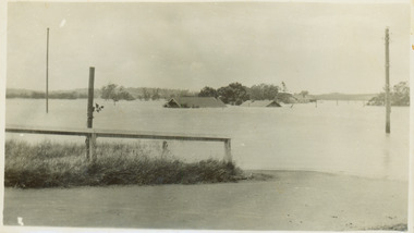
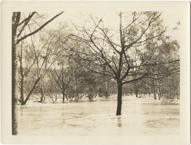
Photograph, Floods in North Kew, 1934
... Floods in North Kew, 1934. Chipperfield's Boat House under flood....Chipperfield's Boat House under flood. Floods in North Kew Photograph Photograph ...Living with natural processes was frequently a challenge to early European settlers and later residents of what was in the 1850s administered by the Borondara Road Board. This was compounded by the area being bounded on three sides by rivers (Yarra River, Koonung Creek and Gardiner's Creek). In 1849, the historian James Bonwick recorded that "our district [Kew] suffered considerably. Mr Wade speaks of 80 acres, out of 100 acres of his cultivated paddock, covered by water." Newspapers continued to describe major flooding in Kew in 1863, 1869, 1878, 1880, 1889, 1891, 1916 and 1934. While the construction of the Upper Yarra dam in 1957 reduced the levels of flowing downstream, local and riverine floods continue.The Kew Historical Society's pictures and map collections testify to the impact of flooding in the district. They have historical importance in documenting the extent of flooding in the district and its affects on homes, services and recreation. Numerous photographs record flooding throughout the Twentieth Century.Floods in North Kew, 1934. Chipperfield's Boat House under flood.floods (kew) 1934, yarra river, chipperfield's boat house -
 Kew Historical Society Inc
Photograph, Chipperfield's Boat House & Floating Pontoon, 1934
... A number of boat houses operated on both sides of the River Yarra at Kew. Chipperfield's Boat House was located on the Yarra near the corner of Kilby and Willsmere Roads....Floating pontoon at Chipperfield's Boat House where the canoes were stored, taken in 1934, presumably before the 1934 Flood. ...Numerous photographs record flooding throughout the Twentieth Century. yarra river chipperfield's boathouse pontoon Floating pontoon at Chipperfield's Boat House where the canoes were stored, taken in 1934, presumably before the 1934 Flood. ...Living with natural processes was frequently a challenge to early European settlers and later residents of what was in the 1850s administered by the Borondara Road Board. This was compounded by the area being bounded on three sides by rivers (Yarra River, Koonung Creek and Gardiner's Creek). In 1849, the historian James Bonwick recorded that "our district [Kew] suffered considerably. Mr Wade speaks of 80 acres, out of 100 acres of his cultivated paddock, covered by water." Newspapers continued to describe major flooding in Kew in 1863, 1869, 1878, 1880, 1889, 1891, 1916 and 1934. While the construction of the Upper Yarra dam in 1957 reduced the levels of flowing downstream, local and riverine floods continue. A number of boat houses operated on both sides of the River Yarra at Kew. Chipperfield's Boat House was located on the Yarra near the corner of Kilby and Willsmere Roads.The Kew Historical Society's pictures and map collections testify to the impact of flooding in the district. They have historical importance in documenting the extent of flooding in the district and its affects on homes, services and recreation. Numerous photographs record flooding throughout the Twentieth Century.Floating pontoon at Chipperfield's Boat House where the canoes were stored, taken in 1934, presumably before the 1934 Flood. This area of the Yarra was shallow with a number of mid river sandbanks and a popular swimming area for locals.yarra river, chipperfield's boathouse, pontoon -
![Flooding at Chipperfield's Boathouse [East Kew], 1934](/media/collectors/550653872162f11fb04854aa/items/58cbaad5d0cec425b474bfb1/item-media/58cf6fbdd0cf9f331490feb0/item-fit-380x285.jpg?cb=6) Kew Historical Society Inc
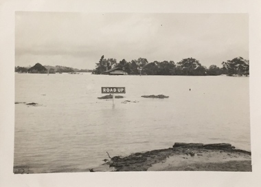
Kew Historical Society IncPhotograph, Flooding at Chipperfield's Boathouse, 1934
... Floods in North Kew, 1934. Chipperfield's Boathouse and the adding Moorings was located beside the Yarra River near the corner of Willsmere and Kilby Roads. ...The flood reached the roof of the Moorings, which can be seen in the photo. Flooding at Chipperfield's Boathouse Photograph Photograph ...Living with natural processes was frequently a challenge to early European settlers and later residents of what was in the 1850s administered by the Borondara Road Board. This was compounded by the area being bounded on three sides by rivers (Yarra River, Koonung Creek and Gardiner's Creek). In 1849, the historian James Bonwick recorded that "our district [Kew] suffered considerably. Mr Wade speaks of 80 acres, out of 100 acres of his cultivated paddock, covered by water." Newspapers continued to describe major flooding in Kew in 1863, 1869, 1878, 1880, 1889, 1891, 1916 and 1934. While the construction of the Upper Yarra dam in 1957 reduced the levels of flowing downstream, local and riverine floods continue.The Kew Historical Society's pictures and map collections testify to the impact of flooding in the district. They have historical importance in documenting the extent of flooding in the district and its affects on homes, services and recreation. Numerous photographs record flooding throughout the Twentieth Century.Floods in North Kew, 1934. Chipperfield's Boathouse and the adding Moorings was located beside the Yarra River near the corner of Willsmere and Kilby Roads. The flood reached the roof of the Moorings, which can be seen in the photo.floods (kew), floods (kew) 1934, yarra river -
 Kew Historical Society Inc
Photograph - Former Kew Post Office : Cotham Road frontage, 1996
... At centre front is the public toilet block, erected in the twentieth century by the City of Kew to designs by Rowland Chipperfield....At centre front is the public toilet block, erected in the twentieth century by the City of Kew to designs by Rowland Chipperfield. Photograph Former Kew Post Office : Cotham Road frontage ...A civic campaign for new public offices developed in Kew in the 1880s. After much deliberation, the location chosen was the junction of Bulleen and Cotham Roads. The buildings were designed by George Watson and John Henry Harvey, architects within the Department of Public Works (Victoria). Building was commenced in 1887, and after one year, the buildings were opened. The Post Office was transferred to the new Commonwealth Government in 1901. The Police Station and Court House, sold by the Victorian Government to the City of Boroondara in 2007, are now a community cultural centre and performing arts venue.The buildings were listed on the Victorian Heritage Register Register (HO885) in 1991. They are historically and architecturally significant to the State of Victoria because Watson and Harvey's designs exhibit diversity in integrating civil offices, they accommodate the apex of road junctions, and they demonstrate a departure from the contemporaneously favoured High Victorian Classical to the Queen Anne style in the design of civic buildings.Panoramic photograph of the entrances from Cotham Road to the Kew Post Office, Court House and Police Station. At centre front is the public toilet block, erected in the twentieth century by the City of Kew to designs by Rowland Chipperfield.kew court house, public offices -- kew (vic), kew police station, kew post office, cotham road -- kew (vic.) -
 Kew Historical Society Inc
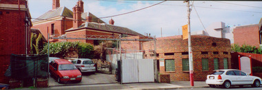
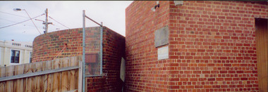
Photograph - Former Kew Court House : rear buildings facing Cotham Road, 1996
... On the left is a red brick public toilet block, designed by Roland Chipperfield. On the right is a red brick garage; a later addition to the Court House complex....On the left is a red brick public toilet block, designed by Roland Chipperfield. On the right is a red brick garage; a later addition to the Court House complex. ...A civic campaign for new public offices developed in Kew in the 1880s. After much deliberation, the location chosen was the junction of Bulleen and Cotham Roads. The buildings were designed by George Watson and John Henry Harvey, architects within the Department of Public Works (Victoria). Building was commenced in 1887, and after one year, the buildings were opened. The Post Office was transferred to the new Commonwealth Government in 1901. The Police Station and Court House, sold by the Victorian Government to the City of Boroondara in 2007, are now a community cultural centre and performing arts venue.The buildings were listed on the Victorian Heritage Register Register (HO885) in 1991. They are historically and architecturally significant to the State of Victoria because Watson and Harvey's designs exhibit diversity in integrating civil offices, they accommodate the apex of road junctions, and they demonstrate a departure from the contemporaneously favoured High Victorian Classical to the Queen Anne style in the design of civic buildings.Original print positive photograph of two buildings on Cotham Road at the rear of the Kew Court House. On the left is a red brick public toilet block, designed by Roland Chipperfield. On the right is a red brick garage; a later addition to the Court House complex.kew court house, public offices -- kew (vic), public toilet -- kew (vic.), kew police station -
 Kew Historical Society Inc
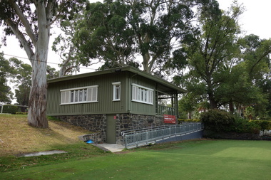
Photograph - Digital Photograph, Robert Baker, Kew Croquet Club, Victoria Park (Kew), 2014
... The Kew Croquet Club rooms were designed by Roland Chipperfield. The Club was founded in 1934 and is located in Victoria Park, Kew....Kew Historical Society Inc Kew Court House 188 High Street Kew melbourne The Kew Croquet Club rooms were designed by Roland Chipperfield. The Club was founded in 1934 and is located in Victoria Park, Kew. kew croquet club - kew (vic) sports -- kew (vic.) ...The Kew Croquet Club rooms were designed by Roland Chipperfield. The Club was founded in 1934 and is located in Victoria Park, Kew.Born digital image of the exterior of the Kew Croquet Club in Victoria Park, Kew.kew croquet club - kew (vic), sports -- kew (vic.) -
 Kew Historical Society Inc
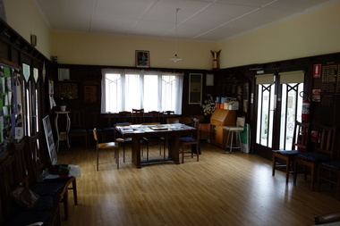
Photograph - Digital Photograph, Robert Baker, Kew Croquet Club, Victoria Park (Kew), 2014
... The Kew Croquet Club rooms were designed by Roland Chipperfield. The Club was founded in 1934 and is located in Victoria Park, Kew....Kew Historical Society Inc Kew Court House 188 High Street Kew melbourne The Kew Croquet Club rooms were designed by Roland Chipperfield. The Club was founded in 1934 and is located in Victoria Park, Kew. kew croquet club - kew (vic) sporting clubs -- kew (vic.) ...The Kew Croquet Club rooms were designed by Roland Chipperfield. The Club was founded in 1934 and is located in Victoria Park, Kew.Born digital image of the interior of the Kew Croquet Club.kew croquet club - kew (vic), sporting clubs -- kew (vic.) -
 Kew Historical Society Inc
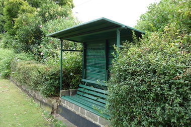
Photograph - Digital Photograph, Robert Baker, Kew Croquet Club, Victoria Park (Kew), 2014
... The Kew Croquet Club rooms were designed by Roland Chipperfield. The Club was founded in 1934 and is located in Victoria Park, Kew....Kew Historical Society Inc Kew Court House 188 High Street Kew melbourne The Kew Croquet Club rooms were designed by Roland Chipperfield. The Club was founded in 1934 and is located in Victoria Park, Kew. kew croquet club - kew (vic) sporting clubs -- kew (vic.) ...The Kew Croquet Club rooms were designed by Roland Chipperfield. The Club was founded in 1934 and is located in Victoria Park, Kew.Born digital image of a seat at the Kew Croquet Club. kew croquet club - kew (vic), sporting clubs -- kew (vic.) -
 Kew Historical Society Inc
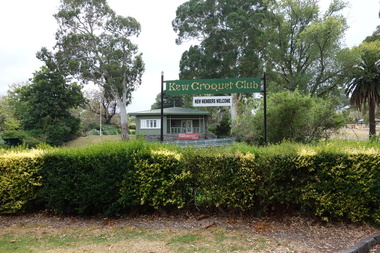
Photograph - Digital Photograph, Robert Baker, Club Sign, Kew Croquet Club, 2014
... The Kew Croquet Club rooms were designed by Roland Chipperfield. The Club was founded in 1934 and is located in Victoria Park, Kew....Kew Historical Society Inc Kew Court House 188 High Street Kew melbourne The Kew Croquet Club rooms were designed by Roland Chipperfield. The Club was founded in 1934 and is located in Victoria Park, Kew. kew croquet club - kew (vic) victoria park - kew (vic) sports -- kew (vic.) ...The Kew Croquet Club rooms were designed by Roland Chipperfield. The Club was founded in 1934 and is located in Victoria Park, Kew.Born digital image of a sign advertising the Kew Croquet Club in Victoria Park, Kew.kew croquet club - kew (vic), victoria park - kew (vic), sports -- kew (vic.) -
 Kew Historical Society Inc
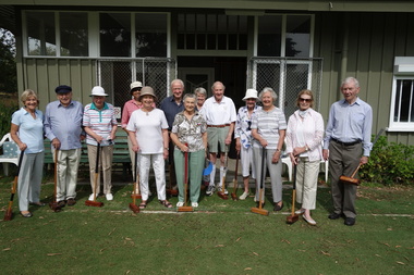
Photograph - Digital Photograph, Robert Baker, Members, Kew Croquet Club, 2014
... The Kew Croquet Club rooms were designed by Roland Chipperfield. The Club was founded in 1934 and is located in Victoria Park, Kew. ...Kew Historical Society Inc Kew Court House 188 High Street Kew melbourne The Kew Croquet Club rooms were designed by Roland Chipperfield. The Club was founded in 1934 and is located in Victoria Park, Kew. ...The Kew Croquet Club rooms were designed by Roland Chipperfield. The Club was founded in 1934 and is located in Victoria Park, Kew. This photo was used as the key photo in an exhibition at the Kew Court House on Sport in Kew.Born digital image of members of the Kew Croquet Club, photographed for an exhibition on Sport in Kew, held at the Kew Court House in 2014.kew croquet club - kew (vic) -
 Mission to Seafarers Victoria
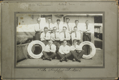
Photograph - Mounted photograph, Sepia, S.S. Tasmania's Football Team, 1922
... Ancell LT/JL ?. Chipperfield / F. Franks...Ancell LT/JL ?. Chipperfield / F. Franks Black and white photograph of S.S. ...This is a photograph of crew members that formed the football team of the S.S. Tasmania. Taken place on the deck of the ship, it is a snapshot in timeAn addition to the collection of crew photographs in the MTSV Collection with all crew members featured in the image named and dated with name of ship making it a useful research and reference image.Black and white photograph of S.S. Tasmania football team in 1922. The photograph is mounted onto a grey green cardboard frame with the text, 'S.S. "Tasmania's" Football Team 1922' on the top. The bottom reads, 'The Happy Thirteen', handwritten in black ink. The photograph itself is of 13 men in three rows, 6 on top row standing, 4 in the middle row sitting on a bench and 3 on the bottom row sitting with their legs crossed. All men have their arms crossed across their chest. On either side of the front row is a lifesaver with the text "S.S. Tasmania/Plymouth". The men are posed on the ships deck. On front mount with photograph: 'S.S "Tasmania's" Football Team 1922' / The Happy Thirteen Inscribed back:of mount names in ink : Thomas Holohay / William Bridges / James. H. Stone / George Angus / James Arthurs / George Arthurs / C. Quinell / C. (Lawrence/labence ?) / W. Manon / M. Zard / I. Ancell LT/JL ?. Chipperfield / F. Franksuniform, team, s.s. tasmania, 1922, football, crew, life buoy, crews and ships -
 Kew Historical Society Inc
Leisure object, Child's Puzzle : Denmark Street Baby Health Centre, c.1950s
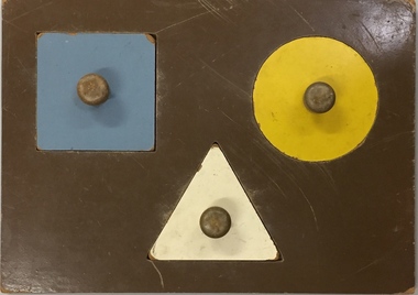
... A building, designed by Roland Chipperfield, was erected, and the Centre previously conducted at the Town Hall transferred there. ...A building, designed by Roland Chipperfield, was erected, and the Centre previously conducted at the Town Hall transferred there. ...In August, 1920, The Kew Town Council decided to establish a Baby Health Centre in Kew. The first Centre was opened in a room in the Town Hall in Walpole Street on 5 November 1920. In May 1939, the Railway Commissioners agreed to lease a site at the Kew Railway Station for a Baby Health Centre for a term of 21 years at 3 pounds per annum. A building, designed by Roland Chipperfield, was erected, and the Centre previously conducted at the Town Hall transferred there. This became known as the Denmark Street Baby Health Centre. (Cr. W.D. Vaughan, Kew’s Civic Century, W.D. Vaughan Pty Ltd., Kew, 1960, pp.96 & 97.)One of a pair of wooden puzzles used in the Denmark Street Baby Health Centre in Kew.denmark street baby health centre - kew (vic), baby health centres - kew (vic), games and puzzles -
 Kew Historical Society Inc
Leisure object, Child's Puzzle : Denmark Street Baby Health Centre, c.1950s
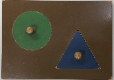
... A building, designed by Roland Chipperfield, was erected, and the Centre previously conducted at the Town Hall transferred there. ...A building, designed by Roland Chipperfield, was erected, and the Centre previously conducted at the Town Hall transferred there. ...In August, 1920, The Kew Town Council decided to establish a Baby Health Centre in Kew. The first Centre was opened in a room in the Town Hall in Walpole Street on 5 November 1920. In May 1939, the Railway Commissioners agreed to lease a site at the Kew Railway Station for a Baby Health Centre for a term of 21 years at 3 pounds per annum. A building, designed by Roland Chipperfield, was erected, and the Centre previously conducted at the Town Hall transferred there. This became known as the Denmark Street Baby Health Centre. (Cr. W.D. Vaughan, Kew’s Civic Century, W.D. Vaughan Pty Ltd., Kew, 1960, pp.96 & 97.)One of a pair of wooden puzzles used in the Denmark Street Baby Health Centre in Kew.denmark street baby health centre - kew (vic), baby health centres - kew (vic), games and puzzles -
 Kew Historical Society Inc
Leisure object, Teddy Bear, 1930-1955
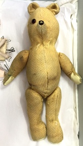
... A building, designed by Roland Chipperfield, was erected, and the Centre previously conducted at the Town Hall transferred there. ...A building, designed by Roland Chipperfield, was erected, and the Centre previously conducted at the Town Hall transferred there. ...In August, 1920, The Kew Town Council decided to establish a Baby Health Centre in Kew. The first Centre was opened in a room in the Town Hall in Walpole Street on 5 November 1920. In May 1939, the Railway Commissioners agreed to lease a site at the Kew Railway Station for a Baby Health Centre for a term of 21 years at 3 pounds per annum. A building, designed by Roland Chipperfield, was erected, and the Centre previously conducted at the Town Hall transferred there. This became known as the Denmark Street Baby Health Centre. (Cr. W.D. Vaughan, Kew’s Civic Century, W.D. Vaughan Pty Ltd., Kew, 1960, pp.96 & 97.)Small teddy bear with only one eye remaining and with a number of repairs. The bear was used by children at the Denmark Street Baby Health Centre in Kew.toys - teddy bears, denmark street baby health centre - kew (vic) -
 Ballarat Tramway Museum
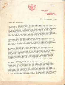
Document - Letter/s, State Electricity Commission of Victoria (SECV), "SECV - Statement regarding proposal to Abandon tramways in City of Ballarat and Borough of Sebastopol and City of Bendigo and Borough of Eaglehawk", 10/09/1970 12:00:00 AM
... Balfour, signed by the SEC Secretary F. Chipperfield, submitting a notice of abandonment in accordance with the SECV Act, with reference to the TRB Enquiry of 1968, the need to lay the motion on the houses of Parliament for 24 days. .2 - Statement - 25 pages duplicated titled "SECV - Statement regarding proposal to Abandon tramways in City of Ballarat and Borough of Sebastopol and City of Bendigo and Borough of Eaglehawk", giving details of the tramways to be abandoned, history, reasons, financial, SEC Obligations following abandonment, future of Tramway's Employees, road reconstruction and future (disposal) of tramway assets....Balfour, signed by the SEC Secretary F. Chipperfield, submitting a notice of abandonment in accordance with the SECV Act, with reference to the TRB Enquiry of 1968, the need to lay the motion on the houses of Parliament for 24 days. .2 - Statement - 25 pages duplicated titled "SECV - Statement regarding proposal to Abandon tramways in City of Ballarat and Borough of Sebastopol and City of Bendigo and Borough of Eaglehawk", giving details of the tramways to be abandoned, history, reasons, financial, SEC Obligations following abandonment, future of Tramway's Employees, road reconstruction and future (disposal) of tramway assets. ...Demonstrates the methodology of the abandonment of the SEC systems in Ballarat and Bendigo by the SEC and the process that had to be undertaken..1 - Letter - 2 page quarto duplicated - dated 10/9/1970 addressed to the Minister for Fuelled and Power J. Balfour, signed by the SEC Secretary F. Chipperfield, submitting a notice of abandonment in accordance with the SECV Act, with reference to the TRB Enquiry of 1968, the need to lay the motion on the houses of Parliament for 24 days. .2 - Statement - 25 pages duplicated titled "SECV - Statement regarding proposal to Abandon tramways in City of Ballarat and Borough of Sebastopol and City of Bendigo and Borough of Eaglehawk", giving details of the tramways to be abandoned, history, reasons, financial, SEC Obligations following abandonment, future of Tramway's Employees, road reconstruction and future (disposal) of tramway assets."D1775" in ink on top sheet right hand corner.trams, tramways, sec, closure, ballarat, bendigo, parliament, notices and information, borough of sebastopol, borough of eaglehawk, city of ballaarat, city of bendigo -
 Surrey Hills Historical Society Collection
Photograph, Holy Trinity Kindergarten Sunday School teachers, 1920s
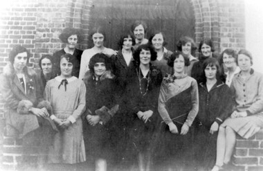
... Identified as: Back LtoR: Doris Wiles, Doris Hearne, Beryl Hearne, …, Mary Chipperfield, Lal Clark, … Centre: Patience Cornell Front: … Wilson, Jessie Collins, Muriel Chipperfield, Una Blakie, Marj Andrews, Myra Lock, Joy Dicker Patience Cornell was the daughter of Frank and Blanche Cornell. ...Identified as: Back LtoR: Doris Wiles, Doris Hearne, Beryl Hearne, …, Mary Chipperfield, Lal Clark, … Centre: Patience Cornell Front: … Wilson, Jessie Collins, Muriel Chipperfield, Una Blakie, Marj Andrews, Myra Lock, Joy Dicker Patience Cornell was the daughter of Frank and Blanche Cornell. ...Miss Patience Cornell, the leader of the group, is in the centre. Training classes were held for leaders at St Pauls Cathedral and St Johns, concluding with examinations. They then trained their assistants. Holy Trinity was known for implementing new ideas and programs for their 70 children. Far right is Miss Joy Dicker, who was leader from 1930 for 30 years. Identified as: Back LtoR: Doris Wiles, Doris Hearne, Beryl Hearne, …, Mary Chipperfield, Lal Clark, … Centre: Patience Cornell Front: … Wilson, Jessie Collins, Muriel Chipperfield, Una Blakie, Marj Andrews, Myra Lock, Joy Dicker Patience Cornell was the daughter of Frank and Blanche Cornell. Frank Cornell was first listed in Surrey Hills in 1906 at (6) Lorne Parade. In 1908 the listing gives his occupation as a clerk. He was born in 1869 in Richmond, Victoria and died 15 April 1917 in Surrey Hills from a stroke. His wife Blanche Annie Parsons Cornell (nee Bracher) was born in 1869 in Hokitika, New Zealand; she died on 21 January 1940. Children were: Gilbert Frank Cornell (b1894, Hawthorn; d1908, at Frankston beach, an accidental drowning) Ruth Amelia Cornell (b 1899, Kew; d 29 May 1977, Kew) Lorna Amy Cornell (b 1906, Surrey Hills; d unknown) Patience Blanche Cornell (b1907, Surrey Hills; d unknown). Ruth Amelia married David Ellis, c1922 in Surrey Hills. David was a dentist who practised in Surrey Hills for many years. Patience (Pat) Blanche married Norman Henry Brewer (1893–1975) in 1931 in Surrey Hills. A black and white photograph of sixteen girls standing in the doorway of a church.(miss) patience cornell, (miss) joy dicker, (ms) doris wiles, (ms) doris hearne, (ms) beryl hearne, (ms) mary chipperfield, (ms) lal clark, (ms) -, wilson, (ms) jessie collins, (ms) muriel chipperfield, (ms) una blakie, (ms) myra lock, holy trinity church of england, kindergarten teachers, clothing and dress, 1920-1929, (ms) marj andrews -
 Kew Historical Society Inc
Booklet - Old Kew Golf Links Estate, 1926
... The brochure is notable as it includes photographs of Kew East Primary School, the former Kew Golf Club clubhouse, and 'The Moorings' Boathouse (aka Chipperfield's Boat House). The aerial photograph, overlaid with names of notable sites, on the final page is of interest as it shows the area before the intrusion of the Eastern Freeway, which resulted in changing the course of a section of the Yarra River. ...Subdivisions -- Kew East (Vic) Chipperfield's Boathouse Kew East primary School Kew Golf Club 8-page brochure advertising 80 residential home sites for sale in a subdivision called the 'Old Kew Golf Links Estate'. ...Subdivision plans and real estate flyers/brochures reveal a number of aspects of urban development and history. The Kew Historical Society's collection of these plans, as well as advertisements extracted from magazines, cover key aspects of community development and architectural history of Kew and Kew Eat as well as surrounding suburbs. While most of the plans in the collection were gifted to the Society by the former City of Kew, a number of other plans and advertisements have been donated by individuals, of which this is an example.8-page brochure advertising 80 residential home sites for sale in a subdivision called the 'Old Kew Golf Links Estate'. These sites had historic importance in Kew's history as they had previously belonged to Kodak Pty Ltd who were refused permission by Kew Council to use the land for industrial development. The estate, advertised was advertised as being within five miles of Melbourne. The brochure is notable as it includes photographs of Kew East Primary School, the former Kew Golf Club clubhouse, and 'The Moorings' Boathouse (aka Chipperfield's Boat House). The aerial photograph, overlaid with names of notable sites, on the final page is of interest as it shows the area before the intrusion of the Eastern Freeway, which resulted in changing the course of a section of the Yarra River. old kew golf links estate, subdivision -- kew (vic.), subdivisions -- kew east (vic), chipperfield's boathouse, kew east primary school, kew golf club -
 Kew Historical Society Inc
Photograph - Country Roads Board and Denmark Street Baby Health Centre, Ron Setford, 1961
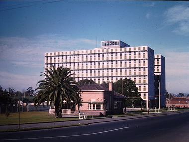
... The single-storey cream brick building was designed by Roland Chipperfield. The Country Roads Board (1913–83), later renamed VicRoads, transferred its headquarters from the Royal Exhibition Building to Kew in 1961, following the completion of two modernist eight-storey office towers in 1960. ...The single-storey cream brick building was designed by Roland Chipperfield. The Country Roads Board (1913–83), later renamed VicRoads, transferred its headquarters from the Royal Exhibition Building to Kew in 1961, following the completion of two modernist eight-storey office towers in 1960. ...Ron Setford and his wife Grace Setford lived in Tanner Avenue, East Kew, from c.1946 to c.1995. A keen photographer, he recorded the changing face of Kew over a 20 year period. Apart from 30 photographs of built structures and places in Kew dating from 1960 and 1961, 145 of his 35mm colour slides chronicle the development of the Eastern Freeway through the Yarra Valley over a five year period from c.1972 to c.1977. This important collection was donated to the Society by his granddaughter in 2025.This collection of 175 35mm slides is of local and statewide significance, owing to its subject matter, particularly the major development of road transport infrastructure during the 1970s with the construction of the Eastern Freeway. The photographer also took care to annotate and date most of his slides which enable the researcher to pinpoint temporal and spatial locations.A photograph providing a visual contrast of the pre and post-World War II architectural styles of the Denmark Street Baby Health Centre and two of the Country Roads Board office buildings. Each was built on part of the land fronting the Kew branch line. In May 1939, the Railway Commissioners agreed to lease a site at the Kew Railway Station for a Baby Health Centre. The single-storey cream brick building was designed by Roland Chipperfield. The Country Roads Board (1913–83), later renamed VicRoads, transferred its headquarters from the Royal Exhibition Building to Kew in 1961, following the completion of two modernist eight-storey office towers in 1960. The VicRoads buildings were closed in 2024, and there is ongoing debate about what replaces them.Nilron setford, photographs -- kew (vic.) -- 1960s, country roads board, vicroads, denmark street -- kew (vic.), denmark street baby health centre -
 Kew Historical Society Inc
Photograph - Peel Street Health Centre : Official Opening, 1930
... The Peel Street building was designed by Mr Chipperfield. Messrs McIntosh and Taylor were the successful tenderers, the price being 1,240 pounds. ...The Peel Street building was designed by Mr Chipperfield. Messrs McIntosh and Taylor were the successful tenderers, the price being 1,240 pounds. ...The North Kew Centre was the third established at North Kew. It followed a lease of a house at 50 Willsmere Road. The Peel Street building was designed by Mr Chipperfield. Messrs McIntosh and Taylor were the successful tenderers, the price being 1,240 pounds. The North Kew Baby Health Centre was finally opened on 18 June 1930 in the presence of the mayor, councillors and citizens of Kew, and representatives of the Infant Welfare Council. A report in The Age of 19 June described the opening in detail as well as the features of the new Centre. These included: "The rooms ... filled with flowers, pink and mauve hydrangeas and native heath, and the walls are adorned, with a charming frieze, representing windmills, flocks and a fairy tale goose girl. On the walls are hygiene editions of the funniest of Belloc's "Cautionary Tales" revised as posters, Outside there is promise of a gay garden, and a lovely view of green fields sloping to a shining bend of the river." Early photographic record of the opening of an early baby health centre in Kew.[Badly damaged] black and white photograph of the opening of the North Kew Baby Health Centre in Peel Street. The photo is mounted on card, and shows mothers and their children on the veranda, and officials at right. The latter includes the Mayoress and probably Vera Scantlebury. All mothers wear hats as do most of the children. [When the photograph was presented to the Society in 1979, it was described in the first Acquisitions Register as framed. Some time after that it was removed from its frame and badly broken. A separate photocopy of the original photograph is also held in the collection.]Earliest inscription: "Peel Street Health Centre / Official Opening 1930 / donated by Sr Costello and Sr Bewish [sic] 1979 / Copy purchased by ..... for Centre". Old Accession number in Texta: "KH-133 Kew Historical Society". Separate later label: "Opening North Kew Baby Health centre 1930". north kew baby health centre, peel street (kew), baby health centres - kew (vic) -
 Kew Historical Society Inc
Photograph, Marnie McLeod, Floods of the River Yarra at Kew, 1916
... One or two low-lying houses have been flooded. Chipperfield's boat shed at Willsmere is nearly covered, and some Chinese gardens in the vicinity are several feet under water."...One or two low-lying houses have been flooded. Chipperfield's boat shed at Willsmere is nearly covered, and some Chinese gardens in the vicinity are several feet under water." ...The donation was accompanied by the following letter from the donor: "Hi. I found these in with family photos. Taken by family as Mamie McLeod was living in Fellows Street, Kew, so would be near there. Retain (or discard) as you see fit." [Donor's name and address withheld from public view]. To gain an insight into the flood levels at Kew, it is worth reading newspaper accounts of the event. The Age published an article - Valuable Gardens Destroyed at Kew - on 25 September 1916: "VALUABLE GARDENS DESTROYED AT KEW. From the heights of Studley Park, Kew, a splendid view of the flood waters can be obtained, and yesterday afternoon, despite continuous rain, crowds of citizens assembled there to witness the spectacle. There is a vast stretch of water some 300 or 400 yards broad, above the foot bridge connecting Gipps-street, Collingwood, and Studley Park. The river is only about 3 feet from the top of the embankment connecting with the ramp of the bridge on the Studiey Park side. When the upper llood waters come down it is almost a certainty that tne embankment will be submerged and the bridge rendered impassible. Below the bridge the waters again stretch out, and have submerged all the low-lying land on the Collingwood side and invaded the back premises ot the Kodak Co., Phoenix Biscuit Factory, a tannery adjoining thereto, the Shamrock Brewery, and Chinese gardens in the vicinity. At Walmer-street-bridge, at the end of Studley Park, the low-lying land on the Kew side is covered with water to the depth of many feet. Tlie land in question is owned in a great part by Mr Frank Lavers who haa gone in for intense culture on a pretty liberal scale on both the slopes of the hill and on the river flat. On the latter he is cultivating many acres of asparagus, and has at a considerable cost spent three years in preparing the ground and installing an irrigation system, reticulated from the Yan Yean water supply. This year the asparagus was put down, and the plants were in a promising condition. Tlie flood waters are now flowing fast over the land. The crop is ruined, and three years' work and expenditure destroyed. Mr. Laver's private residence fortunately is high above flood level, but two houses he owns off Young-street have been flooded out. Having been warned in time, the tenants removed their furniture hefore the water came down to Mr. Laver's residence, where they themselves have been given accommodation in the meantime. All the river flats in East Kew are under water. One or two low-lying houses have been flooded. Chipperfield's boat shed at Willsmere is nearly covered, and some Chinese gardens in the vicinity are several feet under water."This, and the other three photographs donated of floods in Kew are believed to be the earliest in the collection. Together with our original MMBW River Yarra map showing flood levels, these items, when compared allow researchers to gain a visual perspective of the extent of the flood in 1916. Black and white photograph of flooded trees in Kew with rising dry ground in distance.Inscription on reverse in pencil: "Flood River Yarra Kew Vic"river yarra, kew, floods 1916 -
 Kew Historical Society Inc
Photograph, Marnie McLeod, Floods on the River Yarra at Kew, 1916
... One or two low-lying houses have been flooded. Chipperfield's boat shed at Willsmere is nearly covered, and some Chinese gardens in the vicinity are several feet under water."...One or two low-lying houses have been flooded. Chipperfield's boat shed at Willsmere is nearly covered, and some Chinese gardens in the vicinity are several feet under water." ...The donation was accompanied by the following letter from the donor: "Hi. I found these in with family photos. Taken by family as Mamie McLeod was living in Fellows Street, Kew, so would be near there. Retain (or discard) as you see fit." [Donor's name and address withheld from public view]. To gain an insight into the flood levels at Kew, it is worth reading newspaper accounts of the event. The Age published an article - Valuable Gardens Destroyed at Kew - on 25 September 1916: "VALUABLE GARDENS DESTROYED AT KEW. From the heights of Studley Park, Kew, a splendid view of the flood waters can be obtained, and yesterday afternoon, despite continuous rain, crowds of citizens assembled there to witness the spectacle. There is a vast stretch of water some 300 or 400 yards broad, above the foot bridge connecting Gipps-street, Collingwood, and Studley Park. The river is only about 3 feet from the top of the embankment connecting with the ramp of the bridge on the Studiey Park side. When the upper llood waters come down it is almost a certainty that tne embankment will be submerged and the bridge rendered impassible. Below the bridge the waters again stretch out, and have submerged all the low-lying land on the Collingwood side and invaded the back premises ot the Kodak Co., Phoenix Biscuit Factory, a tannery adjoining thereto, the Shamrock Brewery, and Chinese gardens in the vicinity. At Walmer-street-bridge, at the end of Studley Park, the low-lying land on the Kew side is covered with water to the depth of many feet. Tlie land in question is owned in a great part by Mr Frank Lavers who haa gone in for intense culture on a pretty liberal scale on both the slopes of the hill and on the river flat. On the latter he is cultivating many acres of asparagus, and has at a considerable cost spent three years in preparing the ground and installing an irrigation system, reticulated from the Yan Yean water supply. This year the asparagus was put down, and the plants were in a promising condition. Tlie flood waters are now flowing fast over the land. The crop is ruined, and three years' work and expenditure destroyed. Mr. Laver's private residence fortunately is high above flood level, but two houses he owns off Young-street have been flooded out. Having been warned in time, the tenants removed their furniture hefore the water came down to Mr. Laver's residence, where they themselves have been given accommodation in the meantime. All the river flats in East Kew are under water. One or two low-lying houses have been flooded. Chipperfield's boat shed at Willsmere is nearly covered, and some Chinese gardens in the vicinity are several feet under water."This, and the other three photographs donated of floods in Kew are believed to be the earliest in the collection. Together with our original MMBW River Yarra map showing flood levels, these items, when compared allow researchers to gain a visual perspective of the extent of the flood in 1916. Panoramic view, believed to be looking north towards Fairfield from the Zig-Zag Bridge on the River Yarra. The inscription on the reverese identifies it as taken before 1920.Inscription on reverse in ink "(pre 1920) Flood from Zig-zag bridge Yarra River, Kew Vic."river yarra, kew, floods 1916, zig-zag bridge -
 Kew Historical Society Inc
Photograph, Marnie McLeod, Flood, River Yarra, Kew, 1916
... One or two low-lying houses have been flooded. Chipperfield's boat shed at Willsmere is nearly covered, and some Chinese gardens in the vicinity are several feet under water."...One or two low-lying houses have been flooded. Chipperfield's boat shed at Willsmere is nearly covered, and some Chinese gardens in the vicinity are several feet under water." ...The donation was accompanied by the following letter from the donor: "Hi. I found these in with family photos. Taken by family as Mamie McLeod was living in Fellows Street, Kew, so would be near there. Retain (or discard) as you see fit." [Donor's name and address withheld from public view]. To gain an insight into the flood levels at Kew, it is worth reading newspaper accounts of the event. The Age published an article - Valuable Gardens Destroyed at Kew - on 25 September 1916: "VALUABLE GARDENS DESTROYED AT KEW. From the heights of Studley Park, Kew, a splendid view of the flood waters can be obtained, and yesterday afternoon, despite continuous rain, crowds of citizens assembled there to witness the spectacle. There is a vast stretch of water some 300 or 400 yards broad, above the foot bridge connecting Gipps-street, Collingwood, and Studley Park. The river is only about 3 feet from the top of the embankment connecting with the ramp of the bridge on the Studiey Park side. When the upper llood waters come down it is almost a certainty that tne embankment will be submerged and the bridge rendered impassible. Below the bridge the waters again stretch out, and have submerged all the low-lying land on the Collingwood side and invaded the back premises ot the Kodak Co., Phoenix Biscuit Factory, a tannery adjoining thereto, the Shamrock Brewery, and Chinese gardens in the vicinity. At Walmer-street-bridge, at the end of Studley Park, the low-lying land on the Kew side is covered with water to the depth of many feet. Tlie land in question is owned in a great part by Mr Frank Lavers who haa gone in for intense culture on a pretty liberal scale on both the slopes of the hill and on the river flat. On the latter he is cultivating many acres of asparagus, and has at a considerable cost spent three years in preparing the ground and installing an irrigation system, reticulated from the Yan Yean water supply. This year the asparagus was put down, and the plants were in a promising condition. Tlie flood waters are now flowing fast over the land. The crop is ruined, and three years' work and expenditure destroyed. Mr. Laver's private residence fortunately is high above flood level, but two houses he owns off Young-street have been flooded out. Having been warned in time, the tenants removed their furniture hefore the water came down to Mr. Laver's residence, where they themselves have been given accommodation in the meantime. All the river flats in East Kew are under water. One or two low-lying houses have been flooded. Chipperfield's boat shed at Willsmere is nearly covered, and some Chinese gardens in the vicinity are several feet under water."This, and the other three photographs donated of floods in Kew are believed to be the earliest in the collection. Together with our original MMBW River Yarra map showing flood levels, these items, when compared allow researchers to gain a visual perspective of the extent of the flood in 1916. Small black and white photograph of flooded trees in Kew.Inscription on reverse in ink "Flood R. Yarra Kew Vicriver yarra, kew, floods 1916 -
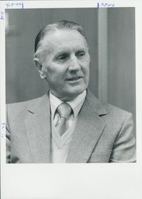
 Uniting Church Archives - Synod of Victoria
BW photo, Undated
... Jock was ordained in 1945 & married two days later to Elsie Chipperfield, with whom he had worked at the Trustees Executors and Agency. ...Jock was ordained in 1945 & married two days later to Elsie Chipperfield, with whom he had worked at the Trustees Executors and Agency. ...JOHN CORBEN LAVENDER (Jock) Jock was born in Ivanhoe, but spent most of his youth in Northcote where his father was a bank manager, and where he attended primary school, high school and the Methodist church in High Street which became a central point in his life. He took his first job in the dispatch office at McPhersons nut and bolt factory in North Richmond in 1935. After a short time at McPhersons he moved to the Trustees Executors and Agency Company in 1936. While working at the Trustees Jock developed the conviction that his vocation lay with the church. This necessitated studying Matriculation at night school for two years as well as working and studying to become a Local Preacher. The minister at Northcote at the time was the Rev.F.T.Cleverdon who helped him prepare to apply as a candidate for Ordination. Before going to university and Queen’s for his arts degree and theological training, Mr Cleverdon, who was now the minister at Neil Street, Ballarat, offered Jock the opportunity to minister to the small congregation at Brown Hill, Ballarat, which was in his Circuit, and to live with the Cleverdons. He spent a year in Ballarat under the tutelage of Rev.F.T Cleverdon in 1939. Jock was accepted by the 1940 Victorian Methodist Conference as a Candidate for the Ministry and started his studies for his theological training and an arts degree at Melbourne University that year. Because of a shortage of ministers, due to the war, Jock was taken out of Queen’s in 1943 to take charge of two fairly small churches in Caulfield - Hawthorn Road and Bambra Road. Jock was ordained in 1945 & married two days later to Elsie Chipperfield, with whom he had worked at the Trustees Executors and Agency. He had joined the RAAF as a chaplain and was sent to Borneo. Returning to Australia in early 1946, he was then appointed to Orbost for a year, Bracknell in Tasmania in 1948, followed by Reid in Canberra, 1951. The next move was to Portland in 1954. Unfortunately not long after this, Elsie was diagnosed with breast cancer. This necessitated a move back to Melbourne - to Mitcham in 1957. Elsie died in December 1957. This period was a very hard time as Jock had four young daughters but his mother helped out by living in for most of the week until Jock was married to Peg in 1959 and their son was born in 1961. In 1964 Jock was moved to Launceston, his first city church. These years were challenging for Jock as he felt compelled to speak out around social issues, such as the Vietnam War & Aboriginal rights, although many did not agree with his view. In 1969 Jock was moved to Horsham to take up the role of Separated Chairman of the North-Western District responsible for Circuits, ministers and families for policy issues and pastoral concerns over an area from the South Australian border, up to the Murray and over it to Wentworth and Dareton, up river to Swan Hill and south to Ballarat and Daylesford. It was a demanding job but richly rewarding in the relationships made with ministers and their families. In 1971 Jock was elected Secretary of the Methodist Conference and in 1972 was voted President of the Conference. He felt it an honour and a vote of confidence by clergy and lay people The final move was to Geelong in 1976 where Jock was the minister at Wesley until 1983.Jock found Geelong a very satisfying parish in which to finish his active ministry. It was while he was Minister of Wesley Church, Geelong, that the Uniting Church came into being and Jock became the first Chairman of the Barwon Presbytery. There were now two ministers at Wesley – Jock and Alex Peerman, whose joint congregation of St. Giles (Pres) and City Congregational now joined with Wesley to become the City Parish. Jock was very surprised to be elected as the third Moderator of the Uniting Church in Victoria, to take office in 1979/1980 1983 saw retirement to Portarlington several months’ locum in both Canada & Kununurra. When the property at Portarlington became too large to maintain, they moved in 1994 into the current house in Belmont & returned to the Wesley Church here. Deceased c.2015. Rev. John (Jock) Lavender is pictured standing at a microphone, wearing clerical clothingRev. J C Lavenderrev. john (jock) lavender; methodist minister; uniting church minister; -
 Uniting Church Archives - Synod of Victoria
BW photo, 1980s?
... Jock was ordained in 1945 & married two days later to Elsie Chipperfield, with whom he had worked at the Trustees Executors and Agency. ...Jock was ordained in 1945 & married two days later to Elsie Chipperfield, with whom he had worked at the Trustees Executors and Agency. ...JOHN CORBEN LAVENDER (Jock) Jock was born in Ivanhoe, but spent most of his youth in Northcote where his father was a bank manager, and where he attended primary school, high school and the Methodist church in High Street which became a central point in his life. He took his first job in the dispatch office at McPhersons nut and bolt factory in North Richmond in 1935. After a short time at McPhersons he moved to the Trustees Executors and Agency Company in 1936. While working at the Trustees Jock developed the conviction that his vocation lay with the church. This necessitated studying Matriculation at night school for two years as well as working and studying to become a Local Preacher. The minister at Northcote at the time was the Rev.F.T.Cleverdon who helped him prepare to apply as a candidate for Ordination. Before going to university and Queen’s for his arts degree and theological training, Mr Cleverdon, who was now the minister at Neil Street, Ballarat, offered Jock the opportunity to minister to the small congregation at Brown Hill, Ballarat, which was in his Circuit, and to live with the Cleverdons. He spent a year in Ballarat under the tutelage of Rev.F.T Cleverdon in 1939. Jock was accepted by the 1940 Victorian Methodist Conference as a Candidate for the Ministry and started his studies for his theological training and an arts degree at Melbourne University that year. Because of a shortage of ministers, due to the war, Jock was taken out of Queen’s in 1943 to take charge of two fairly small churches in Caulfield - Hawthorn Road and Bambra Road. Jock was ordained in 1945 & married two days later to Elsie Chipperfield, with whom he had worked at the Trustees Executors and Agency. He had joined the RAAF as a chaplain and was sent to Borneo. Returning to Australia in early 1946, he was then appointed to Orbost for a year, Bracknell in Tasmania in 1948, followed by Reid in Canberra, 1951. The next move was to Portland in 1954. Unfortunately not long after this, Elsie was diagnosed with breast cancer. This necessitated a move back to Melbourne - to Mitcham in 1957. Elsie died in December 1957. This period was a very hard time as Jock had four young daughters but his mother helped out by living in for most of the week until Jock was married to Peg in 1959 and their son was born in 1961. In 1964 Jock was moved to Launceston, his first city church. These years were challenging for Jock as he felt compelled to speak out around social issues, such as the Vietnam War & Aboriginal rights, although many did not agree with his view. In 1969 Jock was moved to Horsham to take up the role of Separated Chairman of the North-Western District responsible for Circuits, ministers and families for policy issues and pastoral concerns over an area from the South Australian border, up to the Murray and over it to Wentworth and Dareton, up river to Swan Hill and south to Ballarat and Daylesford. It was a demanding job but richly rewarding in the relationships made with ministers and their families. In 1971 Jock was elected Secretary of the Methodist Conference and in 1972 was voted President of the Conference. He felt it an honour and a vote of confidence by clergy and lay people The final move was to Geelong in 1976 where Jock was the minister at Wesley until 1983.Jock found Geelong a very satisfying parish in which to finish his active ministry. It was while he was Minister of Wesley Church, Geelong, that the Uniting Church came into being and Jock became the first Chairman of the Barwon Presbytery. There were now two ministers at Wesley – Jock and Alex Peerman, whose joint congregation of St. Giles (Pres) and City Congregational now joined with Wesley to become the City Parish. Jock was very surprised to be elected as the third Moderator of the Uniting Church in Victoria, to take office in 1979/1980 1983 saw retirement to Portarlington several months’ locum in both Canada & Kununurra. When the property at Portarlington became too large to maintain, they moved in 1994 into the current house in Belmont & returned to the Wesley Church Geelong.Head and shoulders portrait of the Rev. John (Jock) Lavender, wearing suit and tie.Jock Lavenderrev. john (jock) lavender; methodist minister; uniting church minister; -
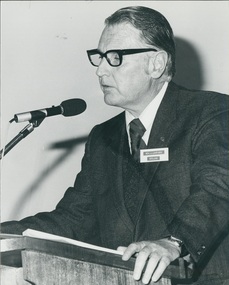 Uniting Church Archives - Synod of Victoria
BW photo, 1979
... Jock was ordained in 1945 & married two days later to Elsie Chipperfield, with whom he had worked at the Trustees Executors and Agency. ...Jock was ordained in 1945 & married two days later to Elsie Chipperfield, with whom he had worked at the Trustees Executors and Agency. ...JOHN CORBEN LAVENDER (Jock) Jock was born in Ivanhoe, but spent most of his youth in Northcote where his father was a bank manager, and where he attended primary school, high school and the Methodist church in High Street which became a central point in his life. He took his first job in the dispatch office at McPhersons nut and bolt factory in North Richmond in 1935. After a short time at McPhersons he moved to the Trustees Executors and Agency Company in 1936. While working at the Trustees Jock developed the conviction that his vocation lay with the church. This necessitated studying Matriculation at night school for two years as well as working and studying to become a Local Preacher. The minister at Northcote at the time was the Rev.F.T.Cleverdon who helped him prepare to apply as a candidate for Ordination. Before going to university and Queen’s for his arts degree and theological training, Mr Cleverdon, who was now the minister at Neil Street, Ballarat, offered Jock the opportunity to minister to the small congregation at Brown Hill, Ballarat, which was in his Circuit, and to live with the Cleverdons. He spent a year in Ballarat under the tutelage of Rev.F.T Cleverdon in 1939. Jock was accepted by the 1940 Victorian Methodist Conference as a Candidate for the Ministry and started his studies for his theological training and an arts degree at Melbourne University that year. Because of a shortage of ministers, due to the war, Jock was taken out of Queen’s in 1943 to take charge of two fairly small churches in Caulfield - Hawthorn Road and Bambra Road. Jock was ordained in 1945 & married two days later to Elsie Chipperfield, with whom he had worked at the Trustees Executors and Agency. He had joined the RAAF as a chaplain and was sent to Borneo. Returning to Australia in early 1946, he was then appointed to Orbost for a year, Bracknell in Tasmania in 1948, followed by Reid in Canberra, 1951. The next move was to Portland in 1954. Unfortunately not long after this, Elsie was diagnosed with breast cancer. This necessitated a move back to Melbourne - to Mitcham in 1957. Elsie died in December 1957. This period was a very hard time as Jock had four young daughters but his mother helped out by living in for most of the week until Jock was married to Peg in 1959 and their son was born in 1961. In 1964 Jock was moved to Launceston, his first city church. These years were challenging for Jock as he felt compelled to speak out around social issues, such as the Vietnam War & Aboriginal rights, although many did not agree with his view. In 1969 Jock was moved to Horsham to take up the role of Separated Chairman of the North-Western District responsible for Circuits, ministers and families for policy issues and pastoral concerns over an area from the South Australian border, up to the Murray and over it to Wentworth and Dareton, up river to Swan Hill and south to Ballarat and Daylesford. It was a demanding job but richly rewarding in the relationships made with ministers and their families. In 1971 Jock was elected Secretary of the Methodist Conference and in 1972 was voted President of the Conference. He felt it an honour and a vote of confidence by clergy and lay people The final move was to Geelong in 1976 where Jock was the minister at Wesley until 1983.Jock found Geelong a very satisfying parish in which to finish his active ministry. It was while he was Minister of Wesley Church, Geelong, that the Uniting Church came into being and Jock became the first Chairman of the Barwon Presbytery. There were now two ministers at Wesley – Jock and Alex Peerman, whose joint congregation of St. Giles (Pres) and City Congregational now joined with Wesley to become the City Parish. Jock was very surprised to be elected as the third Moderator of the Uniting Church in Victoria, to take office in 1979/1980 1983 saw retirement to Portarlington several months’ locum in both Canada & Kununurra. When the property at Portarlington became too large to maintain, they moved in 1994 into the current house in Belmont & returned to the Wesley Church Geelong.Upper body photo of Rev. John (Jock) Lavender (Geelong) speaking at a lectern.Church & Nation 23/5/79, p. 5; Rev. Lavenderrev. john (jock) lavender; methodist minister; uniting church minister; -
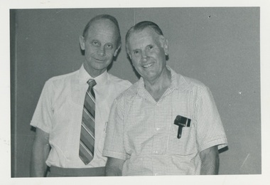 Uniting Church Archives - Synod of Victoria
BW photo, March 1986
... Jock was ordained in 1945 & married two days later to Elsie Chipperfield, with whom he had worked at the Trustees Executors and Agency. ...Jock was ordained in 1945 & married two days later to Elsie Chipperfield, with whom he had worked at the Trustees Executors and Agency. ...John (Jock) Corben Lavender Jock was born in Ivanhoe, but spent most of his youth in Northcote where his father was a bank manager, and where he attended primary school, high school and the Methodist church in High Street which became a central point in his life. He took his first job in the dispatch office at McPhersons nut and bolt factory in North Richmond in 1935. After a short time at McPhersons he moved to the Trustees Executors and Agency Company in 1936. While working at the Trustees Jock developed the conviction that his vocation lay with the church. This necessitated studying Matriculation at night school for two years as well as working and studying to become a Local Preacher. The minister at Northcote at the time was the Rev.F.T.Cleverdon who helped him prepare to apply as a candidate for Ordination. Before going to university and Queen’s for his arts degree and theological training, Mr Cleverdon, who was now the minister at Neil Street, Ballarat, offered Jock the opportunity to minister to the small congregation at Brown Hill, Ballarat, which was in his Circuit, and to live with the Cleverdons. He spent a year in Ballarat under the tutelage of Rev.F.T Cleverdon in 1939. Jock was accepted by the 1940 Victorian Methodist Conference as a Candidate for the Ministry and started his studies for his theological training and an arts degree at Melbourne University that year. Because of a shortage of ministers, due to the war, Jock was taken out of Queen’s in 1943 to take charge of two fairly small churches in Caulfield - Hawthorn Road and Bambra Road. Jock was ordained in 1945 & married two days later to Elsie Chipperfield, with whom he had worked at the Trustees Executors and Agency. He had joined the RAAF as a chaplain and was sent to Borneo. Returning to Australia in early 1946, he was then appointed to Orbost for a year, Bracknell in Tasmania in 1948, followed by Reid in Canberra, 1951. The next move was to Portland in 1954. Unfortunately not long after this, Elsie was diagnosed with breast cancer. This necessitated a move back to Melbourne - to Mitcham in 1957. Elsie died in December 1957. This period was a very hard time as Jock had four young daughters but his mother helped out by living in for most of the week until Jock was married to Peg in 1959 and their son was born in 1961. In 1964 Jock was moved to Launceston, his first city church. These years were challenging for Jock as he felt compelled to speak out around social issues, such as the Vietnam War & Aboriginal rights, although many did not agree with his view. In 1969 Jock was moved to Horsham to take up the role of Separated Chairman of the North-Western District responsible for Circuits, ministers and families for policy issues and pastoral concerns over an area from the South Australian border, up to the Murray and over it to Wentworth and Dareton, up river to Swan Hill and south to Ballarat and Daylesford. It was a demanding job but richly rewarding in the relationships made with ministers and their families. In 1971 Jock was elected Secretary of the Methodist Conference and in 1972 was voted President of the Conference. He felt it an honour and a vote of confidence by clergy and lay people The final move was to Geelong in 1976 where Jock was the minister at Wesley until 1983.Jock found Geelong a very satisfying parish in which to finish his active ministry. It was while he was Minister of Wesley Church, Geelong, that the Uniting Church came into being and Jock became the first Chairman of the Barwon Presbytery. There were now two ministers at Wesley – Jock and Alex Peerman, whose joint congregation of St. Giles (Pres) and City Congregational now joined with Wesley to become the City Parish. Jock was very surprised to be elected as the third Moderator of the Uniting Church in Victoria, to take office in 1979/1980 1983 saw retirement to Portarlington several months’ locum in both Canada & Kununurra. When the property at Portarlington became too large to maintain, they moved in 1994 into the current house in Belmont & returned to the Wesley Church here. In the words of Rev. Prof. Norman Young and Rev. Peter Gador-Whyte at Jock’s funeral service: “We are here today to give thanks to God for Jock Lavender; a gentle man of great compassion, humour and humility. We gather to remember the love he shared so generously the faith he lived so graciously, and the hope he expressed both in his preaching and in his presence. As President of the Methodist Conference and Moderator of the Uniting Church Jock held significant leadership roles within the church and did so with great dignity and grace never lording it over people but leading by example with an inner strength and faith that won respect and trust. There was something really special about him that is hard to put your finger on. We have all been blessed by God through Jock. Mr Alexander Kilgour Alex Kilgour was for many years an active elder and layman in the Presbyterian and then Uniting Church. He was involved in many committees at Synod level for many years. He was a Moderator of the Synod of Victoria of the UCA—one of the first laypeople to take on the role in the early years of the UCA. He was for many years Executive Director of the Resources Commission of the Synod. He worked at Mitchell Brushes (the company owned by Ethel and John Mitchell. B&W photograph. The Rev. John C (Jock) Lavender and Mr Alex Kilgour, dressed in shirts, are standing shoulder to shoulder, facing the camera.C&N 19/3/1986rev. jock lavender; mr alex kilgour; methodist, presbyterian, uniting church; synod appointments; moderator -
Glen Eira Historical Society
Magazine - WESLEY COLLEGE (ELSTERNWICK CAMPUS)
... Wesley College Secondary Schools Helweg-Mikkelsen Leo Helwg-Mikkelsen Tallula Doveton College International Parent Group (IPG) Wesley College (Elsternwick Campus) Schools Carroll James McCrohan Kieran Oakley-Kerr Alice Sharp Emily Elsternwick Primary Years Program (PYP) Abrahams-Fletcher Anais Fraser Isabel Burstin Livvie McDonnell Kim Chipperfield Scarlett Virnik Samuella Elsternwick Music Group Gladstone Parade Magazine WESLEY COLLEGE (ELSTERNWICK CAMPUS) ...This file contains 1 item pertaining to the Elsternwick Campus of Wesley College: 1/A copy of the 123rd Edition of LION, the College’s community magazine, issued 04/2015. Contains and editorial, the principal’s message, a eulogy for ANZACs who attended the College, a series of articles about activities student engaged in during the preceding year, a historical article about the second student ever to attend the College, some items pertaining to the College Foundation, some items pertaining to the Old Wesley Collegian Association, photographs of various reunions, affiliate news, and a list of births, engagements, marriages and deaths. (Please note that only a small minority of the items in the magazine pertain specifically to the Elsternwick Campus, as opposed to the College as a whole).wesley college, secondary schools, helweg-mikkelsen leo, helwg-mikkelsen tallula, doveton college, international parent group (ipg), wesley college (elsternwick campus), schools, carroll james, mccrohan kieran, oakley-kerr alice, sharp emily, elsternwick, primary years program (pyp), abrahams-fletcher anais, fraser isabel, burstin livvie, mcdonnell kim, chipperfield scarlett, virnik samuella, elsternwick music group, gladstone parade