Showing 48 items matching "city of kew -- engineers department"
-
 Kew Historical Society Inc
Photograph - Street Works, Studley Park Road, March 1934
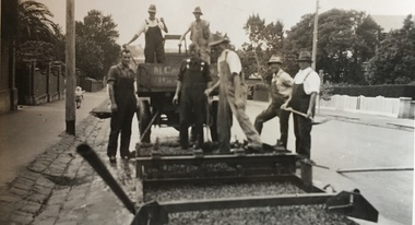
... ...city of kew -- engineers department...This photograph of Council works originated in the City of Kew Engineers Department as a record of works undertaken. ...This photograph of Council works originated in the City of Kew Engineers Department as a record of works undertaken. ...Studley Park Road, like most streets in Kew, was originally a dirt road. Street works during the Great Depression included bituminising major roads in the district. This photograph of Council works originated in the City of Kew Engineers Department as a record of works undertaken. It was given to the collection by a Mrs Fisher in 1998.Well provenanced photograph of Council-funded public works in Kew during the Great Depression. Original sepia monochrome positive of Council workers spreading bitumen in Studley Park Road, Kew.Typed reverse: "B4 / Kew C.C. / Spreading premixed material on Studley Park Road with drag spreader, March 1934"roadworks -- kew (vic.), street works -- kew (vic.), public works kew (vic.), studley park road -- kew (vic.), city of kew -- engineers department, city of kew -- public works -- great depression -- 1930s -
 Kew Historical Society Inc
Photograph - Street Works, Studley Park Road, March 1934
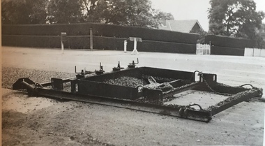
... ...city of kew -- engineers department...This photograph of Council works originated in the City of Kew Engineers Department as a record of works undertaken. ...This photograph of Council works originated in the City of Kew Engineers Department as a record of works undertaken. ...Studley Park Road, like most streets in Kew, was originally a dirt road. Street works during the Great Depression included bituminising major roads in the district. This photograph of Council works originated in the City of Kew Engineers Department as a record of works undertaken. It was given to the collection by a Mrs Fisher in 1998.Well provenanced photograph of Council-funded public works in Kew during the Great Depression. Original sepia monochrome positive of Studley Park Road, Kew.Typed reverse: "B4 / Kew C.C. / Studley Park Road after surfacing with one coat of premixed material spread with drag, March 1934"roadworks -- kew (vic.), street works -- kew (vic.), public works kew (vic.), studley park road -- kew (vic.), city of kew -- engineers department, city of kew -- public works -- great depression -- 1930s -
 Kew Historical Society Inc
Photograph - Street Works, Studley Park Road, March 1934
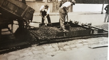
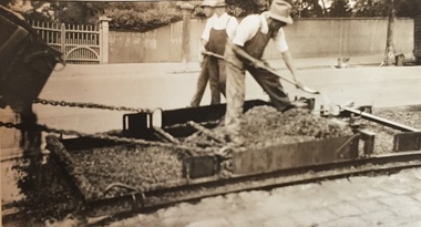
... ...city of kew -- engineers department...This photograph of Council works originated in the City of Kew Engineers Department as a record of works undertaken. ...This photograph of Council works originated in the City of Kew Engineers Department as a record of works undertaken. ...Studley Park Road, like most streets in Kew, was originally a dirt road. Street works during the Great Depression included bituminising major roads in the district. This photograph of Council works originated in the City of Kew Engineers Department as a record of works undertaken. It was given to the collection by a Mrs Fisher in 1998.Well provenanced photograph of Council-funded public works in Kew during the Great Depression. Original sepia monochrome positive of Council workers standing on and beside a dray in Studley Park Road, Kew while resurfacing of the street was taking place. The Kew Junction is just visible behind the men.Typed reverse: "B4 / Kew C.C. / Spreading premixed material on Studley Park Road with drag spreader, view from rear of machine, March 1934"roadworks -- kew (vic.), street works -- kew (vic.), public works kew (vic.), studley park road -- kew (vic.), city of kew -- engineers department, city of kew -- public works -- great depression -- 1930s -
 Kew Historical Society Inc
Photograph - Street Works, Studley Park Road, March 1934
... ...city of kew -- engineers department...This photograph of Council works originated in the City of Kew Engineers Department as a record of works undertaken. ...This photograph of Council works originated in the City of Kew Engineers Department as a record of works undertaken. ...Studley Park Road, like most streets in Kew, was originally a dirt road. Street works during the Great Depression included bituminising major roads in the district. This photograph of Council works originated in the City of Kew Engineers Department as a record of works undertaken. It was given to the collection by a Mrs Fisher in 1998.Well provenanced photograph of Council-funded public works in Kew during the Great Depression. Original sepia photographic positive of a drag used to spread bitumen in Studley Park Road, Kew.Typed reverse: "B4 / Kew C.C. / Drag spreader used for premixed material on Studley Park Road, showing end of strip just with spread, with unsurfaced work on left and completed section on right, March 1934"roadworks -- kew (vic.), street works -- kew (vic.), public works kew (vic.), studley park road -- kew (vic.), city of kew -- engineers department, city of kew -- public works -- great depression -- 1930s -
 Kew Historical Society Inc
Photograph - Street Works, Studley Park Road, March 1934
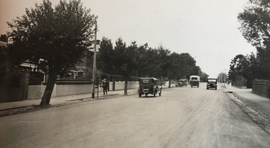
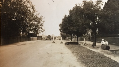
... ...city of kew -- engineers department...This photograph of Council works originated in the City of Kew Engineers Department as a record of works undertaken. ...This photograph of Council works originated in the City of Kew Engineers Department as a record of works undertaken. ...Studley Park Road, like most streets in Kew, was originally a dirt road. Street works during the Great Depression included bituminising major roads in the district. This photograph of Council works originated in the City of Kew Engineers Department as a record of works undertaken. It was given to the collection by a Mrs Fisher in 1998.Well provenanced photograph of Council-funded public works in Kew during the Great Depression. Original sepia photographic positive of Studley Park Road, Kew while resurfacing of the street was taking place. The Kew Junction is just visible in the distance. Boys sitting on a drum at right. Behind them is the brick fence and front entrance to Tara Hall.Typed reverse: "B4 / Kew C.C. / Studley Park Road showing drag spread surfacing with premixed material, unrolled material on the right, March 1934"roadworks -- kew (vic.), street works -- kew (vic.), public works kew (vic.), studley park road -- kew (vic.), city of kew -- engineers department, city of kew -- public works -- great depression -- 1930s -
 Kew Historical Society Inc
Photograph - Street Works, Studley Park Road, March 1934
... ...city of kew -- engineers department...This photograph of Council works originated in the City of Kew Engineers Department as a record of works undertaken. ...This photograph of Council works originated in the City of Kew Engineers Department as a record of works undertaken. ...Studley Park Road, like most streets in Kew, was originally a dirt road. Street works during the Great Depression included bituminising major roads in the district. This photograph of Council works originated in the City of Kew Engineers Department as a record of works undertaken. It was given to the collection by a Mrs Fisher in 1998.Well provenanced photograph of Council-funded public works in Kew during the Great Depression. Original sepia photographic positive of Studley Park Road, Kew while resurfacing of the street was taking place. Typed reverse: "B4 / Kew C.C. / Spreading premixed material on Studley Park Road with drag spreader, March 1934"roadworks -- kew (vic.), street works -- kew (vic.), public works kew (vic.), studley park road -- kew (vic.), city of kew -- engineers department, city of kew -- public works -- great depression -- 1930s -
 Kew Historical Society Inc
Photograph, Stuart Tompkins Studio, Electricity Supply Poles, South Road, Moorabbin, 1965
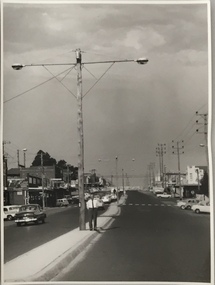
... ...city of kew - engineers department...Kew's needs. The series from which the photograph is drawn provides a snapshot by a commercial photographic studio of each named vicinity in 1965 as well as providing examples of public works infrastructure being commissioned by local government in the 1960s. The photos originally formed part of the Engineering Department's files in the City of Kew before being donated to the kew Historical Society. public infrastructure -- kew (vic.) city of kew - engineers department Typed inscription on reverse: "Electricity Supply Poles. ...Research provided by Stuart Tompkins Studio, Box Hill, into alternatives for median strip street lighting to be used in Burke Road, Kew. The photographers identified variants in different suburbs appropriate to Kew's needs.The series from which the photograph is drawn provides a snapshot by a commercial photographic studio of each named vicinity in 1965 as well as providing examples of public works infrastructure being commissioned by local government in the 1960s. The photos originally formed part of the Engineering Department's files in the City of Kew before being donated to the kew Historical Society.Electricity Supply Poles, South Road, Moorabbin, 1965. Stuart Tompkins Studio provided this photograph for the Kew City Council. The photograph of South Road, Moorabbin, west of Jasper Road, looking east depicts steel poles with two lamps in a median strip and supply wires from pole to pole. The poles were described as 100′ apart. The notation on the rear of the photograph was that there were lamps along the median strip except at intersections. A wooden pole is recognised as supporting heavy supply lines across the road. The steel poles in the photograph were said to be between 3′ to 3.5′ whereas the wooden poles were three to 12.25″ in diameter. [There are three copies of this photograph in the Collection.] Typed inscription on reverse: "Electricity Supply Poles. Photographed for Kew City Council 8/2/65. No.2 South Road - Moorabbin, west of Jasper Road, looking east. Steel poles with two lamps in median strip and supply wires from pole to pole along median strip (poles only 100' apart). Lamps along median only except at intersections. Wooden pole supports heavy supply lines across the road. Wooden poles 3' up and 8 1/2" dia. Wooden poles 3' up and 12 1/2 dia." Studio stamp: "Stuart Tompkins Studio. 547 Station Street, Box Hill. WX1439."public infrastructure -- kew (vic.), city of kew - engineers department -
 Kew Historical Society Inc
Photograph, Stuart Tompkins Studio, Electricity Supply Poles, South Road, Moorabbin, 1965
... city of kew -- engineers department...Kew's needs. The series from which the photograph is drawn provides a snapshot by a commercial photographic studio of each named vicinity in 1965 as well as providing examples of public works infrastructure being commissioned by local government in the 1960s. The photos originally formed part of the Engineering Department's files in the City of Kew before being donated to the kew Historical Society. city of kew -- engineers ...Research provided by Stuart Tompkins Studio, Box Hill, into alternatives for median strip street lighting to be used in Burke Road, Kew. The photographers identified variants in different suburbs appropriate to Kew's needs.The series from which the photograph is drawn provides a snapshot by a commercial photographic studio of each named vicinity in 1965 as well as providing examples of public works infrastructure being commissioned by local government in the 1960s. The photos originally formed part of the Engineering Department's files in the City of Kew before being donated to the kew Historical Society.Electricity Supply Poles, South Road, Moorabbin, 1965. Stuart Tompkins Studio provided this photograph for the Kew City Council. The photograph of South Road, Moorabbin, west of Jasper Road, looking east depicts steel poles with two lamps in a median strip and supply wires from pole to pole. The poles were described as 100′ apart. The notation on the rear of the photograph was that there were lamps along the median strip except at intersections. A wooden pole is recognised as supporting heavy supply lines across the road. The steel poles in the photograph were said to be between 3′ to 3.5′ whereas the wooden poles were three to 12.25″ in diameter. [There are three copies of this photograph in the Collection.] Typed inscription on reverse: "Electricity Supply Poles. Photographed for Kew City Council 8/2/65. No.2 South Road - Moorabbin, west of Jasper Road, looking east. Steel poles with two lamps in median strip and supply wires from pole to pole along median strip (poles only 100' apart). Lamps along median only except at intersections. Wooden pole supports heavy supply lines across the road. Wooden poles 3' up and 8 1/2" dia. Wooden poles 3' up and 12 1/2 dia." Studio stamp: "Stuart Tompkins Studio. 547 Station Street, Box Hill. WX1439."city of kew -- engineers department, public infrastructure -- kew (vic.) -
 Kew Historical Society Inc
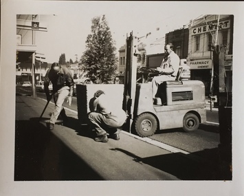
Photograph - Street Beautification: High Street
... ...city of kew -- engineers department...The City Engineer's Department within the former City of Kew, was responsible for public works, including in this instance, street beautification....Kew Historical Society Inc Kew Court House 188 High Street Kew melbourne The City Engineer's Department within the former City of Kew, was responsible for public works, including in this instance, street beautification. street beautification city of kew -- engineers department public works -- kew (vic.) ...The City Engineer's Department within the former City of Kew, was responsible for public works, including in this instance, street beautification.Kew City Council workers installing planter boxes in High Street, Kew. Junction in distance at left.street beautification, city of kew -- engineers department, public works -- kew (vic.) -
 Kew Historical Society Inc
Photograph - Street Beautification: Port Melbourne
... ...city of kew -- engineers department...The City Engineer's Department within the former City of Kew, was responsible for public works, including street beautification. ...Colour photographic positive (faded) of street beautification in Port Melbourne, used as a model by the Engineer's Department of the City of Kew for how civic spaces, including shopping centre precincts, could be improved. ...Kew Historical Society Inc Kew Court House 188 High Street Kew melbourne The City Engineer's Department within the former City of Kew, was responsible for public works, including street beautification. ...The City Engineer's Department within the former City of Kew, was responsible for public works, including street beautification. This photograph was held in the archives of the Department and was subsequently gifted to the Kew Historical Society. Like other examples originally held by the Department, photographs of road works, street beautification, engineering works were often sourced from other municipalities, or countries, to use as references for engineering works and design in Kew.Colour photographic positive (faded) of street beautification in Port Melbourne, used as a model by the Engineer's Department of the City of Kew for how civic spaces, including shopping centre precincts, could be improved. street beautification, city of kew -- engineers department, public works -- kew (vic.), port melbourne -
 Kew Historical Society Inc
Photograph - Carpark: South Melbourne
... city of kew -- engineers department...The City Engineer's Department within the former City of Kew, was responsible for public works, including street beautification. ...Colour photographic positive (faded) of public parking in South Melbourne, perhaps used as a model by the Engineer's Department of the City of Kew for how civic spaces, including shopping centre precincts, could be improved. ...Kew Historical Society Inc Kew Court House 188 High Street Kew melbourne The City Engineer's Department within the former City of Kew, was responsible for public works, including street beautification. ...The City Engineer's Department within the former City of Kew, was responsible for public works, including street beautification. This photograph was held in the archives of the Department and was subsequently gifted to the Kew Historical Society. Like other examples originally held by the Department, photographs of road works, street beautification, engineering works were often sourced from other municipalities, or countries, to use as references for engineering works and design in Kew.Colour photographic positive (faded) of public parking in South Melbourne, perhaps used as a model by the Engineer's Department of the City of Kew for how civic spaces, including shopping centre precincts, could be improved. city of kew -- engineers department, public works -- kew (vic.), south melbourne, carparks, signs -
![Footpath on High Street [Kew]](/media/collectors/550653872162f11fb04854aa/items/6132d892e06408664db76a00/item-media/6132d922e06408664db7752b/item-fit-380x285.jpg?cb=6) Kew Historical Society Inc
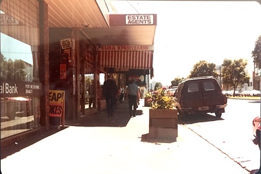
Kew Historical Society IncPhotograph - Footpath on High Street [Kew], 1989
... Photograph of a footpath in High Street Kew, probably donated by the City of Kew's Engineer's Department....Kew Historical Society Inc Kew Court House 188 High Street Kew melbourne Photograph of a footpath in High Street Kew, probably donated by the City of Kew's Engineer's Department. High Street -- Kew (Vic.) street works footpaths "Looking back from pub / High St footpath / 22/8/89" Small, original colour positive [polaroid] photograph of the footpath on the north side of High Street, Kew, looking towards Kew Junction from the vicinity of the Greyhound Hotel. ...Photograph of a footpath in High Street Kew, probably donated by the City of Kew's Engineer's Department.Small, original colour positive [polaroid] photograph of the footpath on the north side of High Street, Kew, looking towards Kew Junction from the vicinity of the Greyhound Hotel."Looking back from pub / High St footpath / 22/8/89"high street -- kew (vic.), street works, footpaths -
 Kew Historical Society Inc
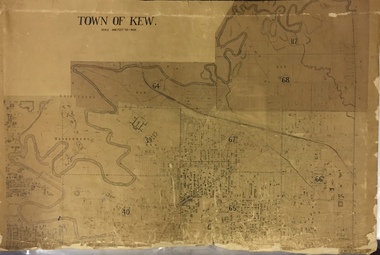
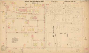
Map, MMBW, MMBW Town of Kew, 1910-21
... The 'assembled' map by the City of Kew Engineer's Department includes scaled down copies of The Melbourne and Metropolitan Board of Works maps, Nos. 39, 40, 64, 65, 66, 67, 68, and 117. ...The 'assembled' map by the City of Kew Engineer's Department includes scaled down copies of The Melbourne and Metropolitan Board of Works maps, Nos. 39, 40, 64, 65, 66, 67, 68, and 117. ...The Melbourne and Metropolitan Board of Works (MMBW) was established by an act of the Victorian Parliament in 1890 to prepare for and to implement a sewerage and water reticulation system across what was then inner Melbourne, its surrounding and middle distance suburbs, including Kew. The MMBW was disbanded in 1991.The map collection of the Kew Historical Society has at its core the historic maps assembled and originally stored in the City Engineer's Department of the City of Kew. These include maps in a number of scales. The vast majority of maps were produced by the MMBW in the first two decades of the twentieth century, and are solid working maps, backed by linen for durability. These maps are historically significant to Kew, the City of Boroondara and to the history of the development of state utilities in Victoria. A number of the Kew maps have additional details added by former municipal officers, including the levels reached by various floods. As these were working documents, information was added to them long after the period of their initial production and distribution.Early map of the Town of Kew, created after 1910, at a scale 440 ft to 1 inch. The 'assembled' map by the City of Kew Engineer's Department includes scaled down copies of The Melbourne and Metropolitan Board of Works maps, Nos. 39, 40, 64, 65, 66, 67, 68, and 117. The map covers the entirety of the Town of Kew, bordered on its north and west by the River Yarra, by Burke Road in the East and Barkers Road in the south. The map shows the extent of urban development by that time, prominent institutions and the outlines of built structures in the municipality. TOWN OF KEW / SCALE 400 FEET TO 1 INCHmelbourne & metropolitan board of works, mmbw maps, mmbw plans, town of kew, cartography -
 Kew Historical Society Inc
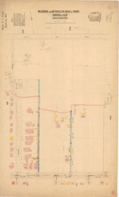
Plan, Melbourne & Metropolitan Board of Works : Borough of Kew : Detail Plan No.1592, 1905
... Kew. The plan was at some stage hand-coloured, possibly by the contractor, but more likely by officers working in the Engineering Department of the Borough and later Town, then City of Kew. The hand-coloured sections of buildings on the plan were used to denote masonry or brick constructions (pink), weatherboard constructions (yellow), and public buildings (grey). In MMBW Plan No.1592, the pink line indicates that area of the plan for which the contracting engineer...Kew. The plan was at some stage hand-coloured, possibly by the contractor, but more likely by officers working in the Engineering Department of the Borough and later Town, then City of Kew. The hand-coloured sections of buildings on the plan were used to denote masonry or brick constructions (pink), weatherboard constructions (yellow), and public buildings (grey). In MMBW Plan No.1592, the pink line indicates that area of the plan for which the contracting engineer ...The Melbourne and Metropolitan Board of Works (MMBW) plans were produced from the 1890s to the 1950s. They were crucial to the design and development of Melbourne's sewerage and drainage system. The plans, at a scale of 40 feet to 1 inch (1:480), provide a detailed historical record of Melbourne streetscapes and environmental features. Each plan covers one or two street blocks (roughly six streets), showing details of buildings, including garden layouts and ownership boundaries, and features such as laneways, drains, bridges, parks, municipal boundaries and other prominent landmarks as they existed at the time each plan was produced. (Source: State Library of Victoria). This plan forms part of a large group of MMBW plans and maps that was donated to the Society by the Mr Poulter, City Engineer of the City of Kew in 1989. Within this collection, thirty-five hand-coloured plans, backed with linen, are of statewide significance as they include annotations that provide details of construction materials used in buildings in the first decade of the 20th century as well as additional information about land ownership and usage. The copies in the Public Record Office Victoria and the State Library of Victoria are monochrome versions which do not denote building materials so that the maps in this collection are invaluable and unique tools for researchers and heritage consultants. A number of the plans are not held in the collection of the State Library of Victoria so they have the additional attribute of rarity.Original survey plan, issued by the MMBW to a contractor with responsibility for constructing sewers in the area identified on the plan within the Borough of Kew. The plan was at some stage hand-coloured, possibly by the contractor, but more likely by officers working in the Engineering Department of the Borough and later Town, then City of Kew. The hand-coloured sections of buildings on the plan were used to denote masonry or brick constructions (pink), weatherboard constructions (yellow), and public buildings (grey). In MMBW Plan No.1592, the pink line indicates that area of the plan for which the contracting engineer was responsible. Included in the Plan are a number of primarily brick villas in a section of Belmont Avenue off Cotham Road. The house ‘Uvadale’ north of Belmont Avenue, and facing Cotham Road is also included in the contract. Excluded from the contract but shown on the Plan are ‘Glendonald’, ‘Mont Belmont’ and ‘Gilden’.melbourne and metropolitan board of works, detail plans, survey plans - borough of kew, mmbw 1592, cartography -
 Kew Historical Society Inc
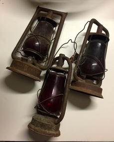
Equipment, City of Kew, Traffic Warning Lantern, 1945-1965
... One of three traffic warning lanterns donated by the City of Kew in 1984. The lanterns were used by the City Engineers Department for emergency street lighting to indicate dangerous conditions. ...Kew Historical Society Inc Kew Court House 188 High Street Kew melbourne One of three traffic warning lanterns donated by the City of Kew in 1984. The lanterns were used by the City Engineers Department for emergency street lighting to indicate dangerous conditions. ...One of three traffic warning lanterns donated by the City of Kew in 1984. The lanterns were used by the City Engineers Department for emergency street lighting to indicate dangerous conditions. The red glass in the lanterns symbolically represented danger.The Kew Historical Society is fortunate that the City Engineer, Mr Poulter, donated a number of items held by the City of Kew to the Society for safekeeping, rather than identifying them for destruction. The most significant items donated included old maps, including those issued by the Board of Works. Other items included photographs of public works undertaken by the Department. These traffic warning lanterns, while less historically significant, are indicative of a period of rapid urban development in the district during the post war period.City of Kew warning lantern (left) previously located in various streets and plant nurserytraffic lanterns -- city of kew, emergency lighting, public works -- kew (vic.) -
 Kew Historical Society Inc
Equipment, City of Kew, Traffic Warning Lantern, 1945-1965
... One of three traffic warning lanterns donated by the City of Kew in 1984. The lanterns were used by the City Engineers Department for emergency street lighting to indicate dangerous conditions. ...Kew Historical Society Inc Kew Court House 188 High Street Kew melbourne One of three traffic warning lanterns donated by the City of Kew in 1984. The lanterns were used by the City Engineers Department for emergency street lighting to indicate dangerous conditions. ...One of three traffic warning lanterns donated by the City of Kew in 1984. The lanterns were used by the City Engineers Department for emergency street lighting to indicate dangerous conditions. The red glass in the lanterns symbolically represented danger.The Kew Historical Society is fortunate that the City Engineer, Mr Poulter, donated a number of items held by the City of Kew to the Society for safekeeping, rather than identifying them for destruction. The most significant items donated included old maps, including those issued by the Board of Works. Other items included photographs of public works undertaken by the Department. These traffic warning lanterns, while less historically significant, are indicative of a period of rapid urban development in the district during the post war period.City of Kew warning lantern (centre) previously located in various streets and plant nurserytraffic lanterns -
 Kew Historical Society Inc
Equipment, City of Kew, Traffic Warning Lantern, 1945-1965
... One of three traffic warning lanterns donated by the City of Kew in 1984. The lanterns were used by the City Engineers Department for emergency street lighting to indicate dangerous conditions. ...Kew Historical Society Inc Kew Court House 188 High Street Kew melbourne One of three traffic warning lanterns donated by the City of Kew in 1984. The lanterns were used by the City Engineers Department for emergency street lighting to indicate dangerous conditions. ...One of three traffic warning lanterns donated by the City of Kew in 1984. The lanterns were used by the City Engineers Department for emergency street lighting to indicate dangerous conditions. The red glass in the lanterns symbolically represented danger.The Kew Historical Society is fortunate that the City Engineer, Mr Poulter, donated a number of items held by the City of Kew to the Society for safekeeping, rather than identifying them for destruction. The most significant items donated included old maps, including those issued by the Board of Works. Other items included photographs of public works undertaken by the Department. These traffic warning lanterns, while less historically significant, are indicative of a period of rapid urban development in the district during the post war period.City of Kew warning lantern (right) previously located in various streets and plant nurserytraffic lanterns -
 Kew Historical Society Inc
Plan, City Engineers Department (Heidelberg), City of Heidelberg Plan: Scale 20 chns to 1 inch, 1970-1993
... Primary source annotated by a distinguished local historian. city of heidelberg maps -- heidelberg (vic.) gwen mcwilliam Handwritten annotations by Gwen McWilliam, 1993 Plan of number of areas in the City of Heidelberg showing municipal and ward boundaries, subsequently annotated by the historian Gwen McWilliam, identifying significant landholdings, subdivisions and key dates.The base map was printed in 1970 and annotated c.1993. The plan was donated to the Kew Historical Society by Gwen McWilliam. City of Heidelberg Plan: Scale 20 chns to 1 inch Plan City Engineers Department ...Gwen Barton McWilliam (nee: Nelson), OAM, BA (1933- ). Gwen McWilliam is well known as an authority on the history of Boroondara and the author of a large number of books and pamphlets about the City. She was awarded the medal of the Order of Australia in 2001 ‘for service to the community of Hawthorn and district, particularly through the research, documentation and publication of its history.’ Primary source annotated by a distinguished local historian.Plan of number of areas in the City of Heidelberg showing municipal and ward boundaries, subsequently annotated by the historian Gwen McWilliam, identifying significant landholdings, subdivisions and key dates.The base map was printed in 1970 and annotated c.1993. The plan was donated to the Kew Historical Society by Gwen McWilliam. Handwritten annotations by Gwen McWilliam, 1993city of heidelberg, maps -- heidelberg (vic.), gwen mcwilliam -
 Kew Historical Society Inc
Plan, Melbourne & Metropolitan Board of Works : Borough of Kew : Detail Plan No.1571, 1904
... Kew. The plan was at some stage hand-coloured, possibly by the contractor, but more likely by officers working in the Engineering Department of the Borough and later Town, then City of Kew. The hand-coloured sections of buildings on the plan were used to denote masonry or brick constructions (pink), weatherboard constructions (yellow), and public buildings (grey). This plan is part of a large and historically significant group of MMBW plans and maps that was donated to the Society by the Mr Poulter, City Engineer...Kew. The plan was at some stage hand-coloured, possibly by the contractor, but more likely by officers working in the Engineering Department of the Borough and later Town, then City of Kew. The hand-coloured sections of buildings on the plan were used to denote masonry or brick constructions (pink), weatherboard constructions (yellow), and public buildings (grey). This plan is part of a large and historically significant group of MMBW plans and maps that was donated to the Society by the Mr Poulter, City Engineer ...The Melbourne and Metropolitan Board of Works (MMBW) plans were produced from the 1890s to the 1950s. They were crucial to the design and development of Melbourne's sewerage and drainage system. The plans, at a scale of 40 feet to 1 inch (1:480), provide a detailed historical record of Melbourne streetscapes and environmental features. Each plan covers one or two street blocks (roughly six streets), showing details of buildings, including garden layouts and ownership boundaries, and features such as laneways, drains, bridges, parks, municipal boundaries and other prominent landmarks as they existed at the time each plan was produced. (Source: State Library of Victoria)This plan forms part of a large group of MMBW plans and maps that was donated to the Society by the Mr Poulter, City Engineer of the City of Kew in 1989. Within this collection, thirty-five hand-coloured plans, backed with linen, are of statewide significance as they include annotations that provide details of construction materials used in buildings in the first decade of the 20th century as well as additional information about land ownership and usage. The copies in the Public Record Office Victoria and the State Library of Victoria are monochrome versions which do not denote building materials so that the maps in this collection are invaluable and unique tools for researchers and heritage consultants. A number of the plans are not held in the collection of the State Library of Victoria so they have the additional attribute of rarity.Digital copy of the original survey plan, issued by the MMBW to a contractor with responsibility for constructing sewers in the area identified on the plan within the Borough of Kew. The plan was at some stage hand-coloured, possibly by the contractor, but more likely by officers working in the Engineering Department of the Borough and later Town, then City of Kew. The hand-coloured sections of buildings on the plan were used to denote masonry or brick constructions (pink), weatherboard constructions (yellow), and public buildings (grey). This plan is part of a large and historically significant group of MMBW plans and maps that was donated to the Society by the Mr Poulter, City Engineer of the City of Kew in 1989. When the contracts were let for surveyors to identify and record the extant houses and landscapes within an area for the Board of Works, the contracts were let at separate times, hence the anomaly where two copies of Plan No.1571 exist in our collection. The first of these plans identifies the building materials used in houses bordering Fitzwilliam Street, Edgevale Road, May Street, Malin Street, Davis Street and Wellington Street. The cut off point for the survey was the south side of Wellington Street. By 1903 when the survey was undertaken many of the sites were already built on, particularly those facing Edgevale Road. The plan identifies the preponderance of weatherboard houses in the area. The other version of the plan identifies the buildings between Wellington Street and Cotham Road.melbourne and metropolitan board of works, detail plans, mmbw 1571, cartography -
![Workplace Humour, Engineer's Department [Kew]](/media/collectors/550653872162f11fb04854aa/items/58b818b8d0ce8a1c5052e050/item-media/58b81907d0ce8a1c5052f7dc/item-fit-380x285.jpg?cb=6) Kew Historical Society Inc
Kew Historical Society IncPhotograph, City of Kew, Workplace Humour, Engineer's Department [Kew], 1961-1994
... Kew Historical Society by the City's Engineering Department preceding the amalgamation of Kew into the City of Boroondara. The photograph can be dated to the period 1961-1994 when the Victorian Totalisator Agency Board (TAB) began operations as a state enterprise. The latter was privatised in 1994. workplace humour city of kew Inscription on reverse: "THE BILL DAWSON APPEAL / PLEASE GIVE (CIGARETTE BUTTS OLD TAB TICKETS) / R. GOULD (SEC) P. HUGGINS (TREASURER) / A HAMPER FOR BILL" Public works. An ironic sign in a workplace requesting donations for a hamper. Workplace Humour, Engineer's ...An original photograph donated to the Kew Historical Society by the City's Engineering Department preceding the amalgamation of Kew into the City of Boroondara. The photograph can be dated to the period 1961-1994 when the Victorian Totalisator Agency Board (TAB) began operations as a state enterprise. The latter was privatised in 1994.Public works. An ironic sign in a workplace requesting donations for a hamper. Inscription on reverse: "THE BILL DAWSON APPEAL / PLEASE GIVE (CIGARETTE BUTTS OLD TAB TICKETS) / R. GOULD (SEC) P. HUGGINS (TREASURER) / A HAMPER FOR BILL"workplace humour, city of kew -
 Kew Historical Society Inc
Photograph, Stuart Tompkins Studio, Electricity Supply Poles, South Road, Moorabbin, 1965
... Kew's needs. The series from which the photograph is drawn provides a snapshot by a commercial photographic studio of each named vicinity in 1965 as well as providing examples of public works infrastructure being commissioned by local government in the 1960s. The photos originally formed part of the Engineering Department's files in the City of Kew before being donated to the kew Historical Society. stuart tompkins studio, street lighting, south road (moorabin) 1965 public infrastructure -- city of kew city of kew -- engineer's department Typed inscription on reverse: "Electricity Supply Poles. ...Research provided by Stuart Tompkins Studio, Box Hill, into alternatives for median strip street lighting to be used in Burke Road, Kew. The photographers identified variants in different suburbs appropriate to Kew's needs.The series from which the photograph is drawn provides a snapshot by a commercial photographic studio of each named vicinity in 1965 as well as providing examples of public works infrastructure being commissioned by local government in the 1960s. The photos originally formed part of the Engineering Department's files in the City of Kew before being donated to the kew Historical Society.Electricity Supply Poles, South Road, Moorabbin, 1965. Stuart Tompkins Studio provided this photograph for the Kew City Council. The photograph of South Road, Moorabbin, west of Jasper Road, looking east depicts steel poles with two lamps in a median strip and supply wires from pole to pole. The poles were described as 100′ apart. The notation on the rear of the photograph was that there were lamps along the median strip except at intersections. A wooden pole is recognised as supporting heavy supply lines across the road. The steel poles in the photograph were said to be between 3′ to 3.5′ whereas the wooden poles were three to 12.25″ in diameter. [There are three copies of this photograph in the Collection.] Typed inscription on reverse: "Electricity Supply Poles. Photographed for Kew City Council 8/2/65. No.2 South Road - Moorabbin, west of Jasper Road, looking east. Steel poles with two lamps in median strip and supply wires from pole to pole along median strip (poles only 100' apart). Lamps along median only except at intersections. Wooden pole supports heavy supply lines across the road. Wooden poles 3' up and 8 1/2" dia. Wooden poles 3' up and 12 1/2 dia." Studio stamp: "Stuart Tompkins Studio. 547 Station Street, Box Hill. WX1439."stuart tompkins studio, street lighting, south road (moorabin) 1965, public infrastructure -- city of kew, city of kew -- engineer's department -
 Kew Historical Society Inc
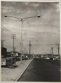
Photograph, Stuart Tompkins Studio, Electricity Supply Poles, North Road, Ormond, 1965
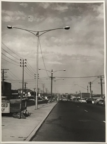
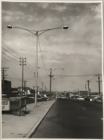
... Kew's needs. The series from which the photograph is drawn provides a snapshot by a commercial photographic studio of each named vicinity in 1965 as well as providing examples of public works infrastructure being commissioned by local government in the 1960s. The photos originally formed part of the Engineering Department's files in the City of Kew before being donated to the kew Historical Society. stuart tompkins studio, street lighting, south road (moorabin) 1965 public infrastructure -- city of kew city of kew -- engineer's department Typed inscription on reverse: "Electricity Supply Poles. ...Research provided by Stuart Tompkins Studio, Box Hill, into alternatives for median strip street lighting to be used in Burke Road, Kew. The photographers identified variants in different suburbs appropriate to Kew's needs.The series from which the photograph is drawn provides a snapshot by a commercial photographic studio of each named vicinity in 1965 as well as providing examples of public works infrastructure being commissioned by local government in the 1960s. The photos originally formed part of the Engineering Department's files in the City of Kew before being donated to the kew Historical Society.Electricity Supply Poles, North Road, Ormond, 1965. Electricity supply poles photographed for the Kew City Council by Stuart Tompkins Studio. The photograph of North Road, Ormond west of Jasper Road, looking east depicts wooden poles carrying two lamps in a median strip and with two on each side alternately. It was noted that the supply wires were from one side only. The poles were described as 3′ above ground and 11.25″ in diameter. The plan was to use this approach for Burke Road, Kew. [There are three copies of this photograph in the Collection.] Typed inscription on reverse: "Electricity Supply Poles. Photographed for Kew City Council 8/2/65. No.1 North Road - Ormond, west of Jasper Road, looking east. Wooden poles carrying two lamps in median strip and two on each side alternately just as is proposed for Burke Road, Kew. Supply wires from one side only. Poles 3' above ground 11 1/4" dia." Studio stamp: "Stuart Tompkins Studio. 547 Station Street, Box Hill. WX1439."stuart tompkins studio, street lighting, south road (moorabin) 1965, public infrastructure -- city of kew, city of kew -- engineer's department -
 Kew Historical Society Inc
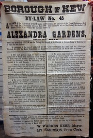
Document, Borough of Kew, Borough of Kew By-Law No.45 : Alexandra Gardens, 1908
... The Kew Historical Society is fortunate that the City Engineer, Mr Poulter, donated a number of items held by the City of Kew to the Society for safekeeping, rather than identifying them for destruction. The most significant items donated included old maps, including those issued by the Board of Works. Other items included photographs of public works undertaken by the Department ...The ‘Alexandra Gardens’ in Cotham Road were designed and laid out by George and Thomas Pockett. The Governor of Victoria officially opened them in 1908. A report of the opening stated that “…the gardens have been laid out in large sloping lawns, divided by wide graveled paths, and dotted with tastefully arranged flower beds, which are now bright with autumn bloom”. The massed beds of shrubs and flowers included beds of chrysanthemums, a specialty of George Pockett, the Garden’s first curator. A large rotunda was constructed in 1910 to mark the Jubilee of Kew. A plaque memorialising the contribution of George Pockett, was attached to the original rotunda after his death in 1922. By 1911, electric lighting was installed to allow the public to access the Gardens, and the concerts that were held within them on summer nights. The Gardens were later to include the Jubilee Fountain, moved from the front of the Kew Post Office in 1925. The Kew Council commissioned the substantial bluestone entrance gates in 1933.The Kew Historical Society is fortunate that the City Engineer, Mr Poulter, donated a number of items held by the City of Kew to the Society for safekeeping, rather than identifying them for destruction. The most significant items donated included old maps, including those issued by the Board of Works. Other items included photographs of public works undertaken by the Department. The By-laws are part of that donation and tell us lots about the social values of the period.The Mayor, Councillors and Burgesses of the Borough of Kew published By-Law No.45 in 1908 to regulate the “Conduct of Persons whilst at or Within the Gardens known as the Alexandra Gardens”. The By-Law also set a charge for “Persons Using or Entering in or upon the said Gardens”. The 17 by-laws included predictable prohibitions on expectorating, using indecent language, interfering with the floral displays, or indeed with the caretaker gardeners. Other acts prohibited included a warning that “Children under the age of ten years not being under the control of some competent person may be removed from said gardens”. The Alexandra Gardens were at one stage surrounded by a picket fence. This might explain the prohibition on climbing upon or getting through over or under any fence at or within the gardens. The financial penalty for breaching the By-Law was determined as “…not exceeding Ten pounds and not less than Five shillings”. This original copy of the By-Law was donated to the Kew Historical Society by the City of Kew.alexandra gardens (cotham road, kew), city of kew -
 Kew Historical Society Inc
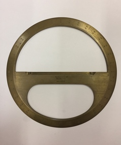
Equipment - Boxed Mathematical Instrument, Kilpatrick & Co, A Victorian cased brass full-circle protractor, 1853-1925
... Kew Historical Society Inc Kew Court House 188 High Street Kew melbourne Kilpatrick & Co., Melbourne were active 1853-1925. A brass protractor, used in developing plans in the Engineer's Department of the City of Kew protractor mathematical instrument city of kew (engineering department) Handwritten inscription on label on lid:" J.R. ...Kilpatrick & Co., Melbourne were active 1853-1925.A brass protractor, used in developing plans in the Engineer's Department of the City of KewCircular brass protractor in a square mahogany lidded case, retailed by Kilpatrick & Co., Melbourne. The protractor was used by staff in the Engineering Department of the former City of Kew. Handwritten inscription on label on lid:" J.R. Gray. G.P Russell,1951, Kew City Engineers used this".protractor, mathematical instrument, city of kew (engineering department) -
 Kew Historical Society Inc
Journal, Kewriosity : April 1987
... city of kew (vic.) kewriosity council newsletters community newsletters Preschool story time at Kew Library / p1&8. Trade Fair at Villa Alba [Villa Alba Preservation Committee] / p1. Dates for April / p2. [Community] Notices / p2. Commentary [The latest on the Kew Recreation Centre] / Cr Joe Ormando, Mayor of Kew p3. So what are you waiting for [Theatre Sports] / p3. Willsmere Billabong [Willsmere Park Advisory Committee] / p4. Review - Visiting the tombs [Premier Theatre Company] / p4. What exactly do they do? [The City Engineers Department ...Preschool story time at Kew Library / p1&8. Trade Fair at Villa Alba [Villa Alba Preservation Committee] / p1. Dates for April / p2. [Community] Notices / p2. Commentary [The latest on the Kew Recreation Centre] / Cr Joe Ormando, Mayor of Kew p3. So what are you waiting for [Theatre Sports] / p3. Willsmere Billabong [Willsmere Park Advisory Committee] / p4. Review - Visiting the tombs [Premier Theatre Company] / p4. What exactly do they do? [The City Engineers Department] / p5. Meet Judy [Price] [Kew Community House] / p6. Second start - basic education for local adults / p6. [Photo - Mark Homden, Assistant Health Surveyor] / p6. Library cuts threaten service [Commonwealth grants] / p7. Ruth [Buckstein] is playing for Australia [Australian Women's Test Team] / p7. Footy news [Kew Football Club] / p8. Keeping you informed - social services [Citizens Advice Bureau] / p8. Good Friday and Easter Services / p8.Kewriosity was a local newsletter combining Kew Council and community news. It was published between November 1983 and June 1994, replacing an earlier Kewriosity [broad] Sheet (1979-84). In producing Kewriosity, Council aimed to provide a range of interesting and informative articles covering its deliberations and decision making, together with items of general interest and importance to the Kew community and information not generally available through daily media outlets.non-fictionPreschool story time at Kew Library / p1&8. Trade Fair at Villa Alba [Villa Alba Preservation Committee] / p1. Dates for April / p2. [Community] Notices / p2. Commentary [The latest on the Kew Recreation Centre] / Cr Joe Ormando, Mayor of Kew p3. So what are you waiting for [Theatre Sports] / p3. Willsmere Billabong [Willsmere Park Advisory Committee] / p4. Review - Visiting the tombs [Premier Theatre Company] / p4. What exactly do they do? [The City Engineers Department] / p5. Meet Judy [Price] [Kew Community House] / p6. Second start - basic education for local adults / p6. [Photo - Mark Homden, Assistant Health Surveyor] / p6. Library cuts threaten service [Commonwealth grants] / p7. Ruth [Buckstein] is playing for Australia [Australian Women's Test Team] / p7. Footy news [Kew Football Club] / p8. Keeping you informed - social services [Citizens Advice Bureau] / p8. Good Friday and Easter Services / p8. publications -- city of kew (vic.), kewriosity, council newsletters, community newsletters -
 Kew Historical Society Inc
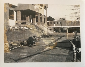
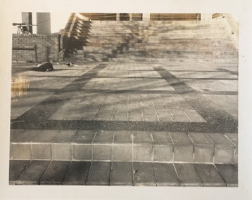
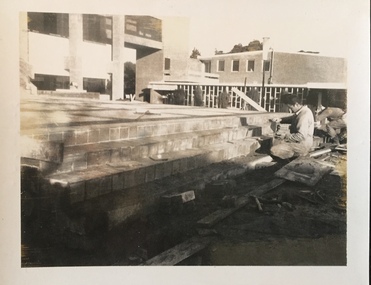
Photograph - Construction of the Kew Civic Centre, 1972
... Kew into the City of Boroondara. These four black and white photographs were taken by a photographer in the City Engineer's Department during the final construction phase. ...The Kew Civic Centre, as opposed to the adjacent Kew Civic Hall (see also Kew City Hall), was built to house a new Council Chamber and Council Offices in 1972. The Kew Library was to be located on the ground floor and accessed from the current carpark. This building replaced the former Town Hall in Walpole Street, Kew which had served as a town hall from 1865-1972. After the sale of the old Town Hall, the new Civic Centre was built to a design of the architects A K Lines, MacFarlane & Marshall. A fit-out of the building was still occurring when councillors and council officers moved into the building. In 1987, the Kew Library (and the Kew Historical Society) moved across the road to the reconfigured Civic Hall. The Civic Centre, pictured here, was ultimately sold to Trinity Grammar School following the amalgamation of Kew into the City of Boroondara.These four black and white photographs were taken by a photographer in the City Engineer's Department during the final construction phase. Each is dated and inscribed with a description.Laying of concrete tiles in the forecourt of the new Kew Civic Centre in 1972. The Civic Hall (now the Kew Library) is in the background. Annotated verso: "Civic Centre - Forecourt / 17.7.72"kew civic centre, kew civic offices, city of kew -- council chamber -
 Kew Historical Society Inc
Photograph - Construction of the Kew Civic Centre, 1972
... Kew into the City of Boroondara. These four black and white photographs were taken by a photographer in the City Engineer's Department during the final construction phase. ...The Kew Civic Centre, as opposed to the adjacent Kew Civic Hall (see also Kew City Hall), was built to house a new Council Chamber and Council Offices in 1972. The Kew Library was to be located on the ground floor and accessed from the current carpark. This building replaced the former Town Hall in Walpole Street, Kew which had served as a town hall from 1865-1972. After the sale of the old Town Hall, the new Civic Centre was built to a design of the architects A K Lines, MacFarlane & Marshall. A fit-out of the building was still occurring when councillors and council officers moved into the building. In 1987, the Kew Library (and the Kew Historical Society) moved across the road to the reconfigured Civic Hall. The Civic Centre, pictured here, was ultimately sold to Trinity Grammar School following the amalgamation of Kew into the City of Boroondara.These four black and white photographs were taken by a photographer in the City Engineer's Department during the final construction phase. Each is dated and inscribed with a description.Forecourt of the new Kew Civic Centre in 1972.Annotated verso: "Civic Centre - Forecourt / 16.7.72"kew civic centre, kew civic offices, city of kew -- council chamber -
 Kew Historical Society Inc
Photograph - Construction of the Kew Civic Centre, 1972
... Kew into the City of Boroondara. These four black and white photographs were taken by a photographer in the City Engineer's Department during the final construction phase. ...The Kew Civic Centre, as opposed to the adjacent Kew Civic Hall (see also Kew City Hall), was built to house a new Council Chamber and Council Offices in 1972. The Kew Library was to be located on the ground floor and accessed from the current carpark. This building replaced the former Town Hall in Walpole Street, Kew which had served as a town hall from 1865-1972. After the sale of the old Town Hall, the new Civic Centre was built to a design of the architects A K Lines, MacFarlane & Marshall. A fit-out of the building was still occurring when councillors and council officers moved into the building. In 1987, the Kew Library (and the Kew Historical Society) moved across the road to the reconfigured Civic Hall. The Civic Centre, pictured here, was ultimately sold to Trinity Grammar School following the amalgamation of Kew into the City of Boroondara.These four black and white photographs were taken by a photographer in the City Engineer's Department during the final construction phase. Each is dated and inscribed with a description.Tiling the steps leading from the forecourt to the new Kew Civic Centre in 1972.Annotated verso: "Civic Centre - Forecourt / 16.7.72"kew civic centre, kew civic offices, city of kew -- council chamber