Showing 67 items matching "city of sunshine map"
-
 Sunshine and District Historical Society Incorporated
Map - City of Sunshine Map
... City of Sunshine Map...City of Sunshine... Map...Map showing the City of Sunshine boundary and streets...City of Sunshine Map...City of Sunshine Map City of Sunshine Map Map showing the City of Sunshine boundary and streets Map City of Sunshine Map ...City of Sunshine Mapcity of sunshine, map -
 Sunshine and District Historical Society Incorporated
Map - City of Sunshine Map
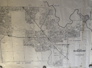
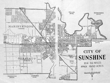
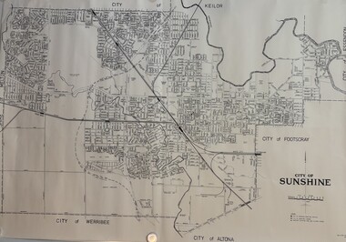
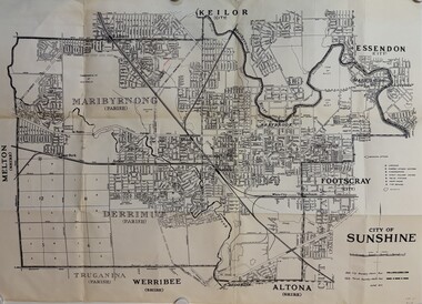
... City of Sunshine Map...City of Sunshine... Map...City of Sunshine Map - undated...Map shows boundary and streets of the City of Sunshine - possibly pre 1961|shows the City of Sunshine as being 30.4 square miles and approximating 19,450 acres|Measures 25cm x 40cm...City of Sunshine Map Map shows boundary and streets of the City of Sunshine - possibly pre 1961|shows the City of Sunshine as being 30.4 square miles and approximating 19,450 acres|Measures 25cm x 40cm City of Sunshine Map - undated Map City of Sunshine Map ...Map shows boundary and streets of the City of Sunshine - possibly pre 1961|shows the City of Sunshine as being 30.4 square miles and approximating 19,450 acres|Measures 25cm x 40cmcity of sunshine, map -
 Sunshine and District Historical Society Incorporated
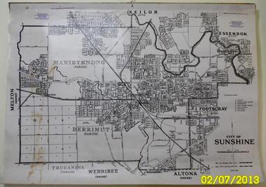
Map - City of Sunshine Map Revision January 1994
... City of Sunshine Map Revision January 1994...Large City of Sunshine Map Revision January 1994 showing streets and other significant points of interest...City of Sunshine Map Revision January 1994...City of Sunshine City of Keilor City of Brimbank City of Footscray City of Maribyrnong City of Sunshine Map Revision January 1994 Large City of Sunshine Map Revision January 1994 showing streets and other significant points of interest Map City of Sunshine Map Revision January 1994 ...City of Sunshine Map Revision January 1994city of sunshine, city of keilor, city of brimbank, city of footscray, city of maribyrnong -
 Sunshine and District Historical Society Incorporated
Map - City of Sunshine Map June 1971
... City of Sunshine Map June 1971...Large map of City of Sunshine showing streets names, location of libraries, elderly citizen centres, kindergartens, infant welfare centres, police stations, court houses, fire brigade stations, railway lines, railway stations, quarries, city boundary lines & parish boundary lines...City of Sunshine Map June 1971...Part of the Gwen Goedecke Collection City of Sunshine City of Sunshine Map June 1971 Large map of City of Sunshine showing streets names, location of libraries, elderly citizen centres, kindergartens, infant welfare centres, police stations, court houses, fire brigade stations, railway lines, railway stations, quarries, city boundary lines & parish boundary lines Map City of Sunshine Map June 1971 ...Part of the Gwen Goedecke CollectionCity of Sunshine Map June 1971city of sunshine -
 Sunshine and District Historical Society Incorporated
Map - City of Sunshine Maps
... City of Sunshine... Map...Collection of City of Sunshine Maps 160 ft to 1 inch Maps showing streets, lots & lot numbers including location of some of the larger factories. ...City of Sunshine Maps 160 ft to 1 inch Maps...City of Sunshine Map City of Sunshine Maps 160 ft to 1 inch Maps Collection of City of Sunshine Maps 160 ft to 1 inch Maps showing streets, lots & lot numbers including location of some of the larger factories. ...City of Sunshine Maps 160 ft to 1 inch Mapscity of sunshine, map -
 Sunshine and District Historical Society Incorporated
Map - CITY OF SUNSHINE MAP June 1967, 1967
... CITY OF SUNSHINE MAP June 1967...City of Sunshine...June 1967...Map...The June 1967 map is of the previous CITY OF SUNSHINE showing City and Parish boundaries, streets, railways, creeks, river etc....Map CITY OF SUNSHINE MAP June 1967 ...The City of Sunshine no longer exists. Part of the eastern area has been annexed by the City of Maribyrnong, and the rest of the old City of Sunshine has been amalgamated with the City of Keilor to form the larger City of Brimbank.This 1967 map is a historical record of the City of Sunshine as it existed 27 years before the amalgamation of Councils, and the creation of the City of Brimbank in 1994.Whitish paper map with black printing that is laminated in clear plastic film, and has a wood slat attached to the top edge. The June 1967 map is of the previous CITY OF SUNSHINE showing City and Parish boundaries, streets, railways, creeks, river etc.Purple ink stamps at top left hand and right hand areas showing address and contact details of 'Sunshine Industrial Promotion Centre.'city of sunshine, june 1967, map, city, parish, boundaries, brimbank -
 Sunshine and District Historical Society Incorporated
Map - City of Sunshine Maps C1976
... City of Sunshine... Map...Collection of rolled up maps showing street names and other locations of interest in the former City of Sunshine C1976...City of Sunshine Maps C1976...City of Sunshine Map City of Sunshine Maps C1976 Collection of rolled up maps showing street names and other locations of interest in the former City of Sunshine C1976 Map City of Sunshine Maps C1976 ...City of Sunshine Maps C1976city of sunshine, map -
 Sunshine and District Historical Society Incorporated
Map - City of Sunshine 1971 Maps
... Collection of City of Sunshine 1971 Maps including a large map showing parish braoders in large black folder...City of Sunshine 1971 Maps...City of Sunshine Maps City of Sunshine 1971 Maps Collection of City of Sunshine 1971 Maps including a large map showing parish braoders in large black folder Map City of Sunshine 1971 Maps ...City of Sunshine 1971 Mapscity of sunshine, maps -
 Sunshine and District Historical Society Incorporated
Map - City Of Sunshine Maps Circa 1971
... City of Sunshine... Map...Folder containing 50 maps of the City of Sunshine circa June 1971...City of Sunshine Map Folder containing 50 maps of the City of Sunshine circa June 1971 Map City Of Sunshine Maps Circa 1971 ...city of sunshine, map -
 Sunshine and District Historical Society Incorporated
Map - Maps of City of Sunshine in sections, Sunshine City Council, Probably 1960s
... City of Sunshine Map...City of Sunshine Map Set of 52 A3 size maps in outer wrapping of bubble wrap. ...city of sunshine map -
 Sunshine and District Historical Society Incorporated
Map - City Of Sunshine Rates Small Maps
... City of Sunshine... Map...Black folder with small maps of the City Of Sunshine Rates showing roads and lot numbers...City of Sunshine Map Rates Small Maps Black folder with small maps of the City Of Sunshine Rates showing roads and lot numbers Map City Of Sunshine Rates Small Maps ...Rates Small Mapscity of sunshine, map -
 Sunshine and District Historical Society Incorporated
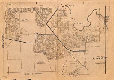
Map - City of Sunshine Ward Election Boundaries 1982, The Advocate, 1982
... The Advocate 3rd August 1982 Page 41|City of Sunshine Election Map...City of Sunshine The Advocate 3rd August 1982 Page 41|City of Sunshine Election Map The Advocate Newpaper Page Map City of Sunshine Ward Election Boundaries 1982 The Advocate ...The Advocate 3rd August 1982 Page 41|City of Sunshine Election Mapcity of sunshine -
 Sunshine and District Historical Society Incorporated
Photograph - Sunshine Technical School Assorted Photos
... Box containing a collection of Sunshine city books, maps, articles, and photos and Sunshine Technical School photos...Multiple Iterms Donated to the Sunshine District Historical Society Sunshine Technical School Techncial School History Sunshine Scrap Book 1913 - 1991|Maths Minutes 1913 Box containing a collection of Sunshine city books, maps, articles, and photos and Sunshine Technical School photos Photograph Sunshine Technical School Assorted Photos ...Multiple Iterms Donated to the Sunshine District Historical SocietyScrap Book 1913 - 1991|Maths Minutes 1913sunshine technical school, techncial school, history, sunshine -
 Sunshine and District Historical Society Incorporated
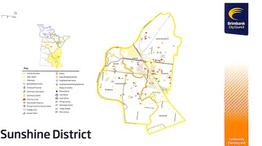
Map - Brimbank City Council Deer Park Keilor St Albans Sunshine and Sydenham District Maps, 2011
... Brimbank City Council Deer Park Keilor St Albans Sunshine and Sydenham District Maps...Map producted by Brimbank City Council for Deer Park|Map producted by Brimbank City Council for Keilor|Map producted by Brimbank City Council for St Albans|Map producted by Brimbank City Council for Sunshine|Map producted by Brimbank City Council for Sydenham...They included request for Name address email phone Age Gender Postcode Preferred Language and a prepaid return address to Brimbank City Council Reply Paid 70 SUNSHINE VIC 3020 Sunshine St.Albans Deer Park Keilor Sydenham Maps Map producted by Brimbank City Council for Deer Park|Map producted by Brimbank City Council for Keilor|Map producted by Brimbank City Council for St Albans|Map producted by Brimbank City Council for Sunshine|Map producted by Brimbank City Council for Sydenham Brimbank City Council Deer Park Keilor St Albans Sunshine and Sydenham District Maps Map Brimbank City Council Deer Park Keilor St Albans Sunshine and Sydenham District Maps ...Produced by Brimbank City Council in 2011 to assist Community, Planning and Development. The cards asked people to Tell Us about your neighbourhood. They included request for Name address email phone Age Gender Postcode Preferred Language and a prepaid return address to Brimbank City Council Reply Paid 70 SUNSHINE VIC 3020Map producted by Brimbank City Council for Deer Park|Map producted by Brimbank City Council for Keilor|Map producted by Brimbank City Council for St Albans|Map producted by Brimbank City Council for Sunshine|Map producted by Brimbank City Council for Sydenhamsunshine, st.albans, deer park, keilor, sydenham, maps -
 Sunshine and District Historical Society Incorporated
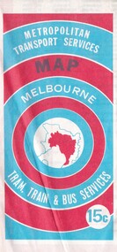
Map - Joseph 'Joe' Wlodarczyk Collection - Metropolitan Transport Services Map, No Date
... Brimbank Library, 301 Hampshire Road, Sunshine 3020. melbourne This combined public transport map provides information on services operated by the Melbourne and Metropolitan Tramways Board, private bus operators and Victorian Railways, Bus Proprietors' Association and the Transport Regulations Board. It was published in the interest of travelers in the Melbourne metropolitan area. This map shows Melbourne's transport network prior to the City ...This combined public transport map provides information on services operated by the Melbourne and Metropolitan Tramways Board, private bus operators and Victorian Railways, Bus Proprietors' Association and the Transport Regulations Board. It was published in the interest of travelers in the Melbourne metropolitan area.This map shows Melbourne's transport network prior to the City Loop being built. Locally the map shows the St. Albans electrification line stopping at the St. Albans Railway Station.Metropolitan Transport Services Map Melbourne Tram, train & Bus Services 15crailways, bus routes, tramlines -
 Sunshine and District Historical Society Incorporated
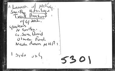
Audio - Launch of McKay Smithy Heritage Trail Brochure Audio Tape
... The Heritage Trail brochure includes maps of Sunshine Victoria showing historical walks, significant historical features and landmarks of the original shire and city, roads, reserves, creeks, late 19th century subdivisions and soldier settlements....Brimbank Library, 301 Hampshire Road, Sunshine 3020. melbourne The Heritage Trail brochure includes maps of Sunshine Victoria showing historical walks, significant historical features and landmarks of the original shire and city, roads, reserves, creeks, late 19th century subdivisions and soldier settlements. ...The Heritage Trail brochure includes maps of Sunshine Victoria showing historical walks, significant historical features and landmarks of the original shire and city, roads, reserves, creeks, late 19th century subdivisions and soldier settlements.Launch of McKay Smithy Heritage Trail Brochure 11/6/2002 Speakers N. Carlton, Olwen Ford, Cr Sam David, Bob Sercombe MHR, Nicola Roxon MHRsunshine heritage trail, hv mckay smithy -
 Sunshine and District Historical Society Incorporated
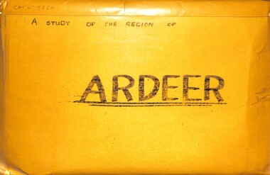
Archive - A Study Of The Region Of Ardeer, Sister Chanel (Sister Julia Williams), 1985
... There's Northing To Study 5384.02 - A Regional Study Of The Region Of Ardeer Page 8.jpg 1978 Municipal Directory 5384.02 - A Regional Study Of The Region Of Ardeer Page 9.jpg Text - Who Fosters It Image - House 5384.02 - A Regional Study Of The Region Of Ardeer Page 10.jpg Image - Market Gardens Yallourn Street Image - Yallourn Street 5384.02 - A Regional Study Of The Region Of Ardeer Page 11.jpg Image - Mother Of God Catholic Church Blanche Street Image - Mother Of God Catholic Church Blanche Street 5384.02 - A Regional Study Of The Region Of Ardeer Page 12.jpg Image - Scotch Thistles Image - Kororoit Creek Bridge West Street To Esmond Street 5384.02 - A Regional Study Of The Region Of Ardeer Page 13.jpg Image - Kororoit Creek Bridge Yalloun Street to Ballarat Road Image - Mother Of God Catholic Church Blanche Street 5384.02 - A Regional Study Of The Region Of Ardeer Page 14.jpg Text - Councillors, Politicians, People 5384.02 - A Regional Study Of The Region Of Ardeer Page 15.jpg Reality 5384.02 - A Regional Study Of The Region Of Ardeer Page 16.jpg Text - Geography Of The City Of Sunshine 5384.02 - A Regional Study Of The Region Of Ardeer Page 18.jpg Melway Map 5384.02 - A Regional Study Of The Region Of Ardeer Page 20.jpg Image - Kororoit Creek From Ballarat Road 5384.02 - A Regional Study Of The Region Of Ardeer Page 22.jpg Text - Basalt Sample Of A Basalt Rock When Laying Foundations For The Polish Community Hall In Helene Street 5384.02 - A Regional Study Of The Region Of Ardeer Page 23.jpg Image - Corner Yallourn Street And Rockbank Road Image - Tower Road Proposed Freeway Site (Now Scrapped) 5384.02 - A Regional Study Of The Region Of Ardeer Page 24.jpg Image - Kororoit Creek Bridge West Street To Esmond Street 5384.02 - A Regional Study Of The Region Of Ardeer Page 25.jpg Kororoit Creek Bridge West Street To Esmond Street 5384.02 - A Regional Study Of The Region Of Ardeer Page 26.jpg Image - Sunshine Swimming Pool Kororoit Creek 5384.02 - A Regional Study Of The Region Of Ardeer Page 27.jpg Text - Industry 5384.02 - A Regional Study Of The Region Of Ardeer Page 28.jpg Text - ICI 5384.02 - A Regional Study Of The Region Of Ardeer Page 29.jpg Text - ICINZ 5384.02 - A Regional Study Of The Region Of Ardeer Page 30.jpg Image - ICIANZ Ballarat Road Entrance 1979 Image - ICIANZ Explosive Reserve View From More Park Esmond Road 5384.02 - A Regional Study Of The Region Of Ardeer Page 31.jpg Image - Forrest Street Corner Fitzgerald Road Image - Entrance To ICIANZ Forrest Street 5384.02 - A Regional Study Of The Region Of Ardeer Page 32.jpg Image - Explosive Train Shunting Across Forrest Street 5384.02 - A Regional Study Of The Region Of Ardeer Page 33.jpg Image - Besco Batteries Forrest Street 5384.02 - A Regional Study Of The Region Of Ardeer Page 34.jpg Image - Queen Of Heaven Catholic Church Holt Street 5384.02 - A Regional Study Of The Region Of Ardeer Page 35.jpg Image - Ukrainian Catholic Church Forrest Street 5384.02 - A Regional Study Of The Region Of Ardeer Page 36.jpg Image - Mother Of God Catholic Church Blanche Street 5384.02 - A Regional Study Of The Region Of Ardeer Page 37.jpg Image - Ukrainian Hall Suspension Street Image - Polish Hall Helene Street 5384.02 - A Regional Study Of The Region Of Ardeer Page 38.jpg Image - Mother Of God Catholic Primary School Blanche Street 5384.02 - A Regional Study Of The Region Of Ardeer Page 39.jpg Image - Ardeer State School Looking From Suspension Street 5384.02 - A Regional Study Of The Region Of Ardeer Page 40.jpg Image - Polish Soccer Club Playgroup 5384.02 - A Regional Study Of The Region Of Ardeer Page 41.jpg Image - Holt Street Shopping Centre Image - Holt Street Milk Bar And Post Office 5384.02 - A Regional Study Of The Region Of Ardeer Page 42.jpg Image - 29 - 31 Maxwell Street Shopping Centre Image - 60 - 62 Maxwell Street Shopping Centre 5384.02 - A Regional Study Of The Region Of Ardeer Page 43.jpg Image - Motor Rail Train At Ardeer Station 5384.02 - A Regional Study Of The Region Of Ardeer Page 44.jpg Image - Ardeer Railway Station 5384.02 - A Regional Study Of The Region Of Ardeer Page 45.jpg Image - Railway Line Pedestrian Crossing Ardeer Station Ridgeway Parade To Forrest Street Image - Railway Line Pedestrian Crossing Ridgeway Parade To West Street 5384.02 - A Regional Study Of The Region Of Ardeer Page 46.jpg Image - Half House Image - Half House 5384.02 - A Regional Study Of The Region Of Ardeer Page 47.jpg Image - Small House Image - Vacant Block 5384.02 - A Regional Study Of The Region Of Ardeer Page 48.jpg Image - House Image - New House 5384.02 - A Regional Study Of The Region Of Ardeer Page 49.jpg Image - House 5384.02 - A Regional Study Of The Region Of Ardeer Page 50.jpg Image - Horse Riding School Forrest Street Image - Horse Riding School Forrest Street 5384.02 - A Regional Study Of The Region Of Ardeer Page 51.jpg Image - Kororoit Creek Image - Playground 5384.02 - A Regional Study Of The Region Of Ardeer Page 52.jpg Image - More Park Women's Sport Centre Esmond Street Image - Old Service Station Old Service Station 5384.02 - A Regional Study Of The Region Of Ardeer Page 53.jpg Image - Vegetable Garden Image - Vegetable Garden 5384.02 - A Regional Study Of The Region Of Ardeer Page 54.jpg Text - Open Space Analysis 5384.02 - A Regional Study Of The Region Of Ardeer Page 55.jpg 1976 Census 5384.02 - A Regional Study Of The Region Of Ardeer Page 56.jpg 1976 Census 5384.02 - A Regional Study Of The Region Of Ardeer Page 57.jpg 1979 Statistics 5384.02 - A Regional Study Of The Region Of Ardeer Page 58.jpg Text - Some Significant Realities 5384.02 - A Regional Study Of The Region Of Ardeer Page 59.jpg Text - A Typical Story From An Ardeerite 5384.02 - A Regional Study Of The Region Of Ardeer Page 60.jpg Text - Bibliography 5384.03 - A Regional Study Of The Region Of Ardeer - Donation Letter.jpg 5384.04 - A Regional Study Of The Region Of Ardeer - Sister Chanel Details.jpg ...There's Northing To Study 5384.02 - A Regional Study Of The Region Of Ardeer Page 8.jpg 1978 Municipal Directory 5384.02 - A Regional Study Of The Region Of Ardeer Page 9.jpg Text - Who Fosters It Image - House 5384.02 - A Regional Study Of The Region Of Ardeer Page 10.jpg Image - Market Gardens Yallourn Street Image - Yallourn Street 5384.02 - A Regional Study Of The Region Of Ardeer Page 11.jpg Image - Mother Of God Catholic Church Blanche Street Image - Mother Of God Catholic Church Blanche Street 5384.02 - A Regional Study Of The Region Of Ardeer Page 12.jpg Image - Scotch Thistles Image - Kororoit Creek Bridge West Street To Esmond Street 5384.02 - A Regional Study Of The Region Of Ardeer Page 13.jpg Image - Kororoit Creek Bridge Yalloun Street to Ballarat Road Image - Mother Of God Catholic Church Blanche Street 5384.02 - A Regional Study Of The Region Of Ardeer Page 14.jpg Text - Councillors, Politicians, People 5384.02 - A Regional Study Of The Region Of Ardeer Page 15.jpg Reality 5384.02 - A Regional Study Of The Region Of Ardeer Page 16.jpg Text - Geography Of The City Of Sunshine 5384.02 - A Regional Study Of The Region Of Ardeer Page 18.jpg Melway Map 5384.02 - A Regional Study Of The Region Of Ardeer Page 20.jpg Image - Kororoit Creek From Ballarat Road 5384.02 - A Regional Study Of The Region Of Ardeer Page 22.jpg Text - Basalt Sample Of A Basalt Rock When Laying Foundations For The Polish Community Hall In Helene Street 5384.02 - A Regional Study Of The Region Of Ardeer Page 23.jpg Image - Corner Yallourn Street And Rockbank Road Image - Tower Road Proposed Freeway Site (Now Scrapped) 5384.02 - A Regional Study Of The Region Of Ardeer Page 24.jpg Image - Kororoit Creek Bridge West Street To Esmond Street 5384.02 - A Regional Study Of The Region Of Ardeer Page 25.jpg Kororoit Creek Bridge West Street To Esmond Street 5384.02 - A Regional Study Of The Region Of Ardeer Page 26.jpg Image - Sunshine Swimming Pool Kororoit Creek 5384.02 - A Regional Study Of The Region Of Ardeer Page 27.jpg Text - Industry 5384.02 - A Regional Study Of The Region Of Ardeer Page 28.jpg Text - ICI 5384.02 - A Regional Study Of The Region Of Ardeer Page 29.jpg Text - ICINZ 5384.02 - A Regional Study Of The Region Of Ardeer Page 30.jpg Image - ICIANZ Ballarat Road Entrance 1979 Image - ICIANZ Explosive Reserve View From More Park Esmond Road 5384.02 - A Regional Study Of The Region Of Ardeer Page 31.jpg Image - Forrest Street Corner Fitzgerald Road Image - Entrance To ICIANZ Forrest Street 5384.02 - A Regional Study Of The Region Of Ardeer Page 32.jpg Image - Explosive Train Shunting Across Forrest Street 5384.02 - A Regional Study Of The Region Of Ardeer Page 33.jpg Image - Besco Batteries Forrest Street 5384.02 - A Regional Study Of The Region Of Ardeer Page 34.jpg Image - Queen Of Heaven Catholic Church Holt Street 5384.02 - A Regional Study Of The Region Of Ardeer Page 35.jpg Image - Ukrainian Catholic Church Forrest Street 5384.02 - A Regional Study Of The Region Of Ardeer Page 36.jpg Image - Mother Of God Catholic Church Blanche Street 5384.02 - A Regional Study Of The Region Of Ardeer Page 37.jpg Image - Ukrainian Hall Suspension Street Image - Polish Hall Helene Street 5384.02 - A Regional Study Of The Region Of Ardeer Page 38.jpg Image - Mother Of God Catholic Primary School Blanche Street 5384.02 - A Regional Study Of The Region Of Ardeer Page 39.jpg Image - Ardeer State School Looking From Suspension Street 5384.02 - A Regional Study Of The Region Of Ardeer Page 40.jpg Image - Polish Soccer Club Playgroup 5384.02 - A Regional Study Of The Region Of Ardeer Page 41.jpg Image - Holt Street Shopping Centre Image - Holt Street Milk Bar And Post Office 5384.02 - A Regional Study Of The Region Of Ardeer Page 42.jpg Image - 29 - 31 Maxwell Street Shopping Centre Image - 60 - 62 Maxwell Street Shopping Centre 5384.02 - A Regional Study Of The Region Of Ardeer Page 43.jpg Image - Motor Rail Train At Ardeer Station 5384.02 - A Regional Study Of The Region Of Ardeer Page 44.jpg Image - Ardeer Railway Station 5384.02 - A Regional Study Of The Region Of Ardeer Page 45.jpg Image - Railway Line Pedestrian Crossing Ardeer Station Ridgeway Parade To Forrest Street Image - Railway Line Pedestrian Crossing Ridgeway Parade To West Street 5384.02 - A Regional Study Of The Region Of Ardeer Page 46.jpg Image - Half House Image - Half House 5384.02 - A Regional Study Of The Region Of Ardeer Page 47.jpg Image - Small House Image - Vacant Block 5384.02 - A Regional Study Of The Region Of Ardeer Page 48.jpg Image - House Image - New House 5384.02 - A Regional Study Of The Region Of Ardeer Page 49.jpg Image - House 5384.02 - A Regional Study Of The Region Of Ardeer Page 50.jpg Image - Horse Riding School Forrest Street Image - Horse Riding School Forrest Street 5384.02 - A Regional Study Of The Region Of Ardeer Page 51.jpg Image - Kororoit Creek Image - Playground 5384.02 - A Regional Study Of The Region Of Ardeer Page 52.jpg Image - More Park Women's Sport Centre Esmond Street Image - Old Service Station Old Service Station 5384.02 - A Regional Study Of The Region Of Ardeer Page 53.jpg Image - Vegetable Garden Image - Vegetable Garden 5384.02 - A Regional Study Of The Region Of Ardeer Page 54.jpg Text - Open Space Analysis 5384.02 - A Regional Study Of The Region Of Ardeer Page 55.jpg 1976 Census 5384.02 - A Regional Study Of The Region Of Ardeer Page 56.jpg 1976 Census 5384.02 - A Regional Study Of The Region Of Ardeer Page 57.jpg 1979 Statistics 5384.02 - A Regional Study Of The Region Of Ardeer Page 58.jpg Text - Some Significant Realities 5384.02 - A Regional Study Of The Region Of Ardeer Page 59.jpg Text - A Typical Story From An Ardeerite 5384.02 - A Regional Study Of The Region Of Ardeer Page 60.jpg Text - Bibliography 5384.03 - A Regional Study Of The Region Of Ardeer - Donation Letter.jpg 5384.04 - A Regional Study Of The Region Of Ardeer - Sister Chanel Details.jpg A large envelope containing over 50 black & white photographs, statistics charts, several maps mounted on coloured card with text. ...Sister Chanel, was later known as Sister Julia Williams. She was professed on the 7th December 1963. She is mentioned in a history of the Brigidine Sister, by Morna Sturrock, Women of Strength, Women of Gentleness: Brigidine Sisters - Victoria Province, David Lovell Publishing, Victoria Australia, 1995, page 290. Sister Chanel (Sister Julia Williams) undertook a study of Ardeer in 1985, as part of her university studies. At the time, she was based at the Brigidine Convent in Blanche Street, Ardeer, opposite the Mother of God Catholic Primary School. Some years later, she was living at Unit 3, 387 Station Street, Bonbeach, Vic, 3196. Today, the Brigidine Convent at Ardeer no longer exists. The buildings have been demolished. The local schools begun by the Brigidine Sisters are now entirely staffed by lay teachers. There is a Brigidine Centre in Malvern, which contains archives relating to the Brigidine Sisters' history.The Brigidine Sisters (often misheard as “Bridiline”) are a long‑established Catholic religious congregation with a major historical presence in Melbourne, especially in education and social justice work. They arrived in Victoria in the 1880s and continue to operate schools, ministries, and community programs across the state.5384.01 - A Regional Study Of The Region Of Ardeer Envelope.jpg Text - A Regional Study Of The Region Of Ardeer 5384.02 - A Regional Study Of The Region Of Ardeer Page 1.jpg Text - A Regional Study Of The Region Of Ardeer 5384.02 - A Regional Study Of The Region Of Ardeer Page 2.jpg 5384.02 - A Regional Study Of The Region Of Ardeer Page 3.jpg Text - Subject HU211 Regionalism And Australia 5384.02 - A Regional Study Of The Region Of Ardeer Page 4.jpg Text - Ardeer Regions Selected 5384.02 - A Regional Study Of The Region Of Ardeer Page 5.jpg Melway Map 5384.02 - A Regional Study Of The Region Of Ardeer Page 6.jpg Text - Ardeer Never Heard Of It. Wheres That? 5384.02 - A Regional Study Of The Region Of Ardeer Page 7.jpg Text - Study The Region of Ardeer. There's Northing To Study 5384.02 - A Regional Study Of The Region Of Ardeer Page 8.jpg 1978 Municipal Directory 5384.02 - A Regional Study Of The Region Of Ardeer Page 9.jpg Text - Who Fosters It Image - House 5384.02 - A Regional Study Of The Region Of Ardeer Page 10.jpg Image - Market Gardens Yallourn Street Image - Yallourn Street 5384.02 - A Regional Study Of The Region Of Ardeer Page 11.jpg Image - Mother Of God Catholic Church Blanche Street Image - Mother Of God Catholic Church Blanche Street 5384.02 - A Regional Study Of The Region Of Ardeer Page 12.jpg Image - Scotch Thistles Image - Kororoit Creek Bridge West Street To Esmond Street 5384.02 - A Regional Study Of The Region Of Ardeer Page 13.jpg Image - Kororoit Creek Bridge Yalloun Street to Ballarat Road Image - Mother Of God Catholic Church Blanche Street 5384.02 - A Regional Study Of The Region Of Ardeer Page 14.jpg Text - Councillors, Politicians, People 5384.02 - A Regional Study Of The Region Of Ardeer Page 15.jpg Reality 5384.02 - A Regional Study Of The Region Of Ardeer Page 16.jpg Text - Geography Of The City Of Sunshine 5384.02 - A Regional Study Of The Region Of Ardeer Page 18.jpg Melway Map 5384.02 - A Regional Study Of The Region Of Ardeer Page 20.jpg Image - Kororoit Creek From Ballarat Road 5384.02 - A Regional Study Of The Region Of Ardeer Page 22.jpg Text - Basalt Sample Of A Basalt Rock When Laying Foundations For The Polish Community Hall In Helene Street 5384.02 - A Regional Study Of The Region Of Ardeer Page 23.jpg Image - Corner Yallourn Street And Rockbank Road Image - Tower Road Proposed Freeway Site (Now Scrapped) 5384.02 - A Regional Study Of The Region Of Ardeer Page 24.jpg Image - Kororoit Creek Bridge West Street To Esmond Street 5384.02 - A Regional Study Of The Region Of Ardeer Page 25.jpg Kororoit Creek Bridge West Street To Esmond Street 5384.02 - A Regional Study Of The Region Of Ardeer Page 26.jpg Image - Sunshine Swimming Pool Kororoit Creek 5384.02 - A Regional Study Of The Region Of Ardeer Page 27.jpg Text - Industry 5384.02 - A Regional Study Of The Region Of Ardeer Page 28.jpg Text - ICI 5384.02 - A Regional Study Of The Region Of Ardeer Page 29.jpg Text - ICINZ 5384.02 - A Regional Study Of The Region Of Ardeer Page 30.jpg Image - ICIANZ Ballarat Road Entrance 1979 Image - ICIANZ Explosive Reserve View From More Park Esmond Road 5384.02 - A Regional Study Of The Region Of Ardeer Page 31.jpg Image - Forrest Street Corner Fitzgerald Road Image - Entrance To ICIANZ Forrest Street 5384.02 - A Regional Study Of The Region Of Ardeer Page 32.jpg Image - Explosive Train Shunting Across Forrest Street 5384.02 - A Regional Study Of The Region Of Ardeer Page 33.jpg Image - Besco Batteries Forrest Street 5384.02 - A Regional Study Of The Region Of Ardeer Page 34.jpg Image - Queen Of Heaven Catholic Church Holt Street 5384.02 - A Regional Study Of The Region Of Ardeer Page 35.jpg Image - Ukrainian Catholic Church Forrest Street 5384.02 - A Regional Study Of The Region Of Ardeer Page 36.jpg Image - Mother Of God Catholic Church Blanche Street 5384.02 - A Regional Study Of The Region Of Ardeer Page 37.jpg Image - Ukrainian Hall Suspension Street Image - Polish Hall Helene Street 5384.02 - A Regional Study Of The Region Of Ardeer Page 38.jpg Image - Mother Of God Catholic Primary School Blanche Street 5384.02 - A Regional Study Of The Region Of Ardeer Page 39.jpg Image - Ardeer State School Looking From Suspension Street 5384.02 - A Regional Study Of The Region Of Ardeer Page 40.jpg Image - Polish Soccer Club Playgroup 5384.02 - A Regional Study Of The Region Of Ardeer Page 41.jpg Image - Holt Street Shopping Centre Image - Holt Street Milk Bar And Post Office 5384.02 - A Regional Study Of The Region Of Ardeer Page 42.jpg Image - 29 - 31 Maxwell Street Shopping Centre Image - 60 - 62 Maxwell Street Shopping Centre 5384.02 - A Regional Study Of The Region Of Ardeer Page 43.jpg Image - Motor Rail Train At Ardeer Station 5384.02 - A Regional Study Of The Region Of Ardeer Page 44.jpg Image - Ardeer Railway Station 5384.02 - A Regional Study Of The Region Of Ardeer Page 45.jpg Image - Railway Line Pedestrian Crossing Ardeer Station Ridgeway Parade To Forrest Street Image - Railway Line Pedestrian Crossing Ridgeway Parade To West Street 5384.02 - A Regional Study Of The Region Of Ardeer Page 46.jpg Image - Half House Image - Half House 5384.02 - A Regional Study Of The Region Of Ardeer Page 47.jpg Image - Small House Image - Vacant Block 5384.02 - A Regional Study Of The Region Of Ardeer Page 48.jpg Image - House Image - New House 5384.02 - A Regional Study Of The Region Of Ardeer Page 49.jpg Image - House 5384.02 - A Regional Study Of The Region Of Ardeer Page 50.jpg Image - Horse Riding School Forrest Street Image - Horse Riding School Forrest Street 5384.02 - A Regional Study Of The Region Of Ardeer Page 51.jpg Image - Kororoit Creek Image - Playground 5384.02 - A Regional Study Of The Region Of Ardeer Page 52.jpg Image - More Park Women's Sport Centre Esmond Street Image - Old Service Station Old Service Station 5384.02 - A Regional Study Of The Region Of Ardeer Page 53.jpg Image - Vegetable Garden Image - Vegetable Garden 5384.02 - A Regional Study Of The Region Of Ardeer Page 54.jpg Text - Open Space Analysis 5384.02 - A Regional Study Of The Region Of Ardeer Page 55.jpg 1976 Census 5384.02 - A Regional Study Of The Region Of Ardeer Page 56.jpg 1976 Census 5384.02 - A Regional Study Of The Region Of Ardeer Page 57.jpg 1979 Statistics 5384.02 - A Regional Study Of The Region Of Ardeer Page 58.jpg Text - Some Significant Realities 5384.02 - A Regional Study Of The Region Of Ardeer Page 59.jpg Text - A Typical Story From An Ardeerite 5384.02 - A Regional Study Of The Region Of Ardeer Page 60.jpg Text - Bibliography 5384.03 - A Regional Study Of The Region Of Ardeer - Donation Letter.jpg 5384.04 - A Regional Study Of The Region Of Ardeer - Sister Chanel Details.jpg -
 Sunshine and District Historical Society Incorporated
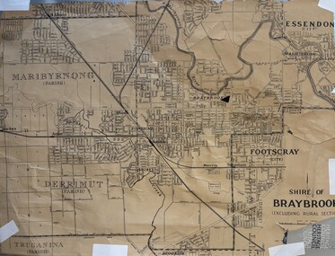
Map - Shire of Braybrook Map, Before 1951
... The map was produced by the Shire of Brabrook which later, in 1951, became the City of Sunshine....The map was produced by the Shire of Brabrook which later, in 1951, became the City of Sunshine. ...The map was produced by the Shire of Brabrook which later, in 1951, became the City of Sunshine.shire of braybrook, braybrook, map -
 Sunshine and District Historical Society Incorporated
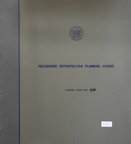
Map - Melbourne Metropolitan Planning Scheme 1968 Map, Melbourne and Metropolitan Board of Works, 1968
... City of Sunshine Melbourne Metropolitan Planning Scheme 1968 Map Collection of Melbourne Metropolitan Planning Scheme 1968 Map mounted in a grey folder Map Melbourne Metropolitan Planning Scheme 1968 Map Melbourne and Metropolitan Board of Works ...Melbourne Metropolitan Planning Scheme 1968 Mapcity of sunshine -
 Sunshine and District Historical Society Incorporated
Map - Melbourne Metropolitan Board of Works Interim Development Order 1959 Maps
... City of Sunshine Melbourne Metropolitan Board of Works Interim Development Order 1959 Maps Collection of Melbourne Metropolitan Board of Works Interim Development Order 1959 Maps mounted 2 grey folders Map Melbourne Metropolitan Board of Works Interim Development Order 1959 Maps ...Melbourne Metropolitan Board of Works Interim Development Order 1959 Mapscity of sunshine -
 Sunshine and District Historical Society Incorporated
Map - City of Sunshine Planning Scheme Maps 1988
... City of Sunshine City of Sunshine Planning Scheme Plans 1988 Collection of pland of the City of Sunshine Planning Scheme Map City of Sunshine Planning Scheme Maps 1988 ...City of Sunshine Planning Scheme Plans 1988city of sunshine -
 Sunshine and District Historical Society Incorporated
Map - Melbourne Metropolitan Planning Scheme Amendment No.1 1968, Snadden, A, et al
... City of Sunshine 34 maps of Melbourne Metropolitan Area Map Melbourne Metropolitan Planning Scheme Amendment No.1 1968 Snadden, A, et al ...city of sunshine -
 Sunshine and District Historical Society Incorporated
Archive - Display Material for Family Focus March 1998, 1998
... Sunshine Like the earlier migrants they often built their own homes and contributed to new schools churches local business and industry Why is the City of Brimbank called Brimbank? The name comes from Brimbank Park, the largest park in the area Opened in 1973 Before that the central part was Brimbank Farm owned by the Goudie Family in the 1870s to 1890s and later John Dodd and his family Various explanatory sheets maps acknowledgments used in the Family Focus display which was collected and researched by Olwen Ford for the Brimbank City Festival in March 1998 Archive Display Material for Family Focus March 1998 ...Thousands of families have lived in the Brimbank area over thousands of years Aboriginal families were here for over 40000 years The first migrant families came from England Ireland and Scotland in the 1830s to 1840s Many came in the gold rushes of the 1850s when the main tracks to the gold fields went through the Brimbank area New families arrived when the first industries developed in the 1870s to 1890s After World Ware Two there was a huge influx of new families to the Brimbank area especially St Albans and Sunshine Like the earlier migrants they often built their own homes and contributed to new schools churches local business and industry Why is the City of Brimbank called Brimbank? The name comes from Brimbank Park, the largest park in the area Opened in 1973 Before that the central part was Brimbank Farm owned by the Goudie Family in the 1870s to 1890s and later John Dodd and his family -
 Sunshine and District Historical Society Incorporated
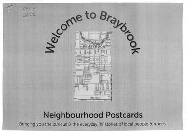
Document - Welcome to Neighbourhood Braybrook Postcards, History At Work Pty Ltd, 2021
... This set features Braybrook, a suburb of Shire of Braybrook and City of Sunshine, prior to the Council mergers in 1996, which created the City of Brimbank. A walking tour map is included that allows one to visit the various points of interest featured in the postcards including The Munition Workers Housing Estate, The basalt plains of the west, Solomon's Ford, Quang Minh Temple, The animal by-products industry, Braybrook Radio Broadcasting Station, Peanut Butter Factory (ETA), Yvonne Barrett Australian Pop Singer, The Marin baluk, Melon Street, Doug Hawkins AFL Champion and Tottenham RAAF....This set features Braybrook, a suburb of Shire of Braybrook and City of Sunshine, prior to the Council mergers in 1996, which created the City of Brimbank. A walking tour map is included that allows one to visit the various points of interest featured in the postcards including The Munition Workers Housing Estate, The basalt plains of the west, Solomon's Ford, Quang Minh Temple, The animal by-products industry, Braybrook Radio Broadcasting Station, Peanut Butter Factory (ETA), Yvonne Barrett Australian Pop Singer, The Marin baluk, Melon Street, Doug Hawkins AFL Champion and Tottenham RAAF. ...History at Work produced a number of Neighbourhood Postcards of various sites throughout Victoria. Neighbourhood Postcards probes the memories of our local streets for histories of local people whose lives, play, work and pre-occupation have shaped our local communities today. This set features Braybrook, a suburb of Shire of Braybrook and City of Sunshine, prior to the Council mergers in 1996, which created the City of Brimbank. A walking tour map is included that allows one to visit the various points of interest featured in the postcards including The Munition Workers Housing Estate, The basalt plains of the west, Solomon's Ford, Quang Minh Temple, The animal by-products industry, Braybrook Radio Broadcasting Station, Peanut Butter Factory (ETA), Yvonne Barrett Australian Pop Singer, The Marin baluk, Melon Street, Doug Hawkins AFL Champion and Tottenham RAAF.Welcome to Neighbourhood Braybrook Postcards Bringing you the curious & everyday history of local people and placesbraybrook, munition workers housing estate, solomon's ford, quang minh temple, braybrook radio broadcasting station, peanut butter factory, eta, yvonne barrett, marin baluk, melon street, doug hawkins, les twentyman, alfred ravenhall, raaf no 1 store, myalla street, braybrook salvation army hall, darnley street, kingsford street, carlton street, joseph solomon -
 Sunshine and District Historical Society Incorporated
Archive - City of Sunshine
... Typed Report General Information on the City of Sunshine 1987 to 1988|Newspaper Article 13 October 1993 The Age How rubish tips can be a big turn on|Envelope Town Clerk Sunshine City Council|Flyer City of Sunshine Community Day Festival 23 April 1994|Brochure City of Sunshine City of the Future Community Meeting 5 March 1994 Moonee Valley|Brochure City of Sunshine Multicultural City of Victoria Community Meeting 14 September 1991 Moonee Valley|Brochure City of Sunshine The Conferring of The Freedom of Entry to the City of Sunshine Upon The First Try City of Sunshine Regional Cadet Unit on 16 May 1987|Brochure City of Sunshine The Conferring of The Freedom of Entry to the City of Sunshine Upon No 5 Flight Air Training Corps Tottenham 18 November 1989|Photograph and photocopies of building with handwritten notes 444 $136.89|Logo of City of Sunshine Victoria|Brochure Your share in Sunshine City of Sunshine A Progressive Municipality|Brochure City of Sunshine The Conferring of the Freedom of the City of Sunshine upon 5th and 6th Battalion The Royal Victoria Regiment 12 February 1994|Hand drawings with handwritten notes 441 $32.09|Hand drawings with handwritten notes 256 $12.64|Hand drawings with handwritten notes 258 $17.233|Hand drawings with handwritten notes 250 $15.60|Hand drawings with handwritten notes 260 $19.72|Hand drawings with handwritten notes 255 $8.26|Hand drawings with handwritten notes 440 $6.19|Hand drawings with handwritten notes 387 $34.09|Hand drawings with handwritten notes 259 $12.49|Brochure City of Sunshine Development Update October 1988|Newsletter Grapewine City of Sunshine Staff Newsletter June 1992|Typed Letter City of Sunshine Community Bus Information Sheet 21 March 1979|Map Greening Sunshine Current Work in Progress 1992 to 1993|Newspaper Article A Place in the Sun Exotic plants along Railway lines|Flyer Sunshine City Council News Vol 1 No 1 August 1974 Inflation Whats happening to Councils Money|Newspaper Article Footscray Advertiser 17 February 1917 Braybrook Council|Flyer Sunshine City Council News Vol 1 No 1 April 1975 Leaping into Sunshine New World|Flyer Sunshine your city August 1961 Facts you should know Administration commended|Flyer Sunshines Gardens Parks and Streets 1991 to 1992|Invitation sent 28 June 1982 Government Reception to farewell Governor General of the Commonwealth of Australia on 8 July 1982 Commissioner AG and Mrs Gillen at National Gallery of Victoria|City of Sunshine Crest Motto is By Industry|Flyer Sunshine City Burke and Wills Camel Cup 24 April 1994 on Massey Ferguson Harvester site|Booklet Sunshine Yearbook 1972 Suburban Services Directories and Yearbooks|Enrolment form City of Sunshine Holiday Programme 7 May to 18 May 1984|Christmas Wishes Card from Chief Secretary Victoria t0 GM Prendergast Christmas 1927|Typed Letter 1 January 1984 A Personal Invitation from the Mayor|Newspaper Article The Advocate 9 September 1992 Public to have say Brooklyn tug of war|Newspaper Article Local Government Focus Special Feature November 1986 The City of Sunshine Multicultural City of Victoria Message from the Mayor|Brochure City of Sunshine Municipal Profile|Brochure City of Sunshine Accommodating the Future A Strategy for Housing Needs|Brochure Sunshine City Centre Development|Photocopy Mayors City of Sunshine|Brochure Local Solutions to a Global Problem our gift to future generations GEC ALSTHOM Energy Park Hulett St Albion|Brochure Melbournes West on the Move Melbournes Western Region Profile|Brochure Sunshine District Centre Market Square Interchange Public Transport|Certificate of Speical Civic Service for the Municipality of Sunshine|Brochure New Municipal Offices City of Sunshine Victoria|Newspaper Article Sunshine Community 1972 Can you imagine what $800 Million dollars looks like|Brochure Shire of Braybrook Office Welcome Home tendered to Maidstone Returned Services Personnel 2nd August 1946|Brochure City of Sunshine Live work and recreate in Sunshine|Sunshine City Council No 7 Council Report|Section of Minutes 24 March 199 Sunshine Logo competition won by Mr Stephen Jones of Laverton|Photocopy of Mayoral Pendant presented to City of Sunshine by Cr AG Pennel JP to commemorate its proclamatonas a city 16 May 1951|Flyer City of Sunshine Corporation Logo 24 March 1992 The logo was chosen from 94 other logos submitted as part of a community competiiton to find a new corporate logo. ...City of Sunshine Typed Report General Information on the City of Sunshine 1987 to 1988|Newspaper Article 13 October 1993 The Age How rubish tips can be a big turn on|Envelope Town Clerk Sunshine City Council|Flyer City of Sunshine Community Day Festival 23 April 1994|Brochure City of Sunshine City of the Future Community Meeting 5 March 1994 Moonee Valley|Brochure City of Sunshine Multicultural City of Victoria Community Meeting 14 September 1991 Moonee Valley|Brochure City of Sunshine The Conferring of The Freedom of Entry to the City of Sunshine Upon The First Try City of Sunshine Regional Cadet Unit on 16 May 1987|Brochure City of Sunshine The Conferring of The Freedom of Entry to the City of Sunshine Upon No 5 Flight Air Training Corps Tottenham 18 November 1989|Photograph and photocopies of building with handwritten notes 444 $136.89|Logo of City of Sunshine Victoria|Brochure Your share in Sunshine City of Sunshine A Progressive Municipality|Brochure City of Sunshine The Conferring of the Freedom of the City of Sunshine upon 5th and 6th Battalion The Royal Victoria Regiment 12 February 1994|Hand drawings with handwritten notes 441 $32.09|Hand drawings with handwritten notes 256 $12.64|Hand drawings with handwritten notes 258 $17.233|Hand drawings with handwritten notes 250 $15.60|Hand drawings with handwritten notes 260 $19.72|Hand drawings with handwritten notes 255 $8.26|Hand drawings with handwritten notes 440 $6.19|Hand drawings with handwritten notes 387 $34.09|Hand drawings with handwritten notes 259 $12.49|Brochure City of Sunshine Development Update October 1988|Newsletter Grapewine City of Sunshine Staff Newsletter June 1992|Typed Letter City of Sunshine Community Bus Information Sheet 21 March 1979|Map Greening Sunshine Current Work in Progress 1992 to 1993|Newspaper Article A Place in the Sun Exotic plants along Railway lines|Flyer Sunshine City Council News Vol 1 No 1 August 1974 Inflation Whats happening to Councils Money|Newspaper Article Footscray Advertiser 17 February 1917 Braybrook Council|Flyer Sunshine City Council News Vol 1 No 1 April 1975 Leaping into Sunshine New World|Flyer Sunshine your city August 1961 Facts you should know Administration commended|Flyer Sunshines Gardens Parks and Streets 1991 to 1992|Invitation sent 28 June 1982 Government Reception to farewell Governor General of the Commonwealth of Australia on 8 July 1982 Commissioner AG and Mrs Gillen at National Gallery of Victoria|City of Sunshine Crest Motto is By Industry|Flyer Sunshine City Burke and Wills Camel Cup 24 April 1994 on Massey Ferguson Harvester site|Booklet Sunshine Yearbook 1972 Suburban Services Directories and Yearbooks|Enrolment form City of Sunshine Holiday Programme 7 May to 18 May 1984|Christmas Wishes Card from Chief Secretary Victoria t0 GM Prendergast Christmas 1927|Typed Letter 1 January 1984 A Personal Invitation from the Mayor|Newspaper Article The Advocate 9 September 1992 Public to have say Brooklyn tug of war|Newspaper Article Local Government Focus Special Feature November 1986 The City of Sunshine Multicultural City of Victoria Message from the Mayor|Brochure City of Sunshine Municipal Profile|Brochure City of Sunshine Accommodating the Future A Strategy for Housing Needs|Brochure Sunshine City Centre Development|Photocopy Mayors City of Sunshine|Brochure Local Solutions to a Global Problem our gift to future generations GEC ALSTHOM Energy Park Hulett St Albion|Brochure Melbournes West on the Move Melbournes Western Region Profile|Brochure Sunshine District Centre Market Square Interchange Public Transport|Certificate of Speical Civic Service for the Municipality of Sunshine|Brochure New Municipal Offices City of Sunshine Victoria|Newspaper Article Sunshine Community 1972 Can you imagine what $800 Million dollars looks like|Brochure Shire of Braybrook Office Welcome Home tendered to Maidstone Returned Services Personnel 2nd August 1946|Brochure City of Sunshine Live work and recreate in Sunshine|Sunshine City Council No 7 Council Report|Section of Minutes 24 March 199 Sunshine Logo competition won by Mr Stephen Jones of Laverton|Photocopy of Mayoral Pendant presented to City of Sunshine by Cr AG Pennel JP to commemorate its proclamatonas a city 16 May 1951|Flyer City of Sunshine Corporation Logo 24 March 1992 The logo was chosen from 94 other logos submitted as part of a community competiiton to find a new corporate logo. ...Typed Report General Information on the City of Sunshine 1987 to 1988|Newspaper Article 13 October 1993 The Age How rubish tips can be a big turn on|Envelope Town Clerk Sunshine City Council|Flyer City of Sunshine Community Day Festival 23 April 1994|Brochure City of Sunshine City of the Future Community Meeting 5 March 1994 Moonee Valley|Brochure City of Sunshine Multicultural City of Victoria Community Meeting 14 September 1991 Moonee Valley|Brochure City of Sunshine The Conferring of The Freedom of Entry to the City of Sunshine Upon The First Try City of Sunshine Regional Cadet Unit on 16 May 1987|Brochure City of Sunshine The Conferring of The Freedom of Entry to the City of Sunshine Upon No 5 Flight Air Training Corps Tottenham 18 November 1989|Photograph and photocopies of building with handwritten notes 444 $136.89|Logo of City of Sunshine Victoria|Brochure Your share in Sunshine City of Sunshine A Progressive Municipality|Brochure City of Sunshine The Conferring of the Freedom of the City of Sunshine upon 5th and 6th Battalion The Royal Victoria Regiment 12 February 1994|Hand drawings with handwritten notes 441 $32.09|Hand drawings with handwritten notes 256 $12.64|Hand drawings with handwritten notes 258 $17.233|Hand drawings with handwritten notes 250 $15.60|Hand drawings with handwritten notes 260 $19.72|Hand drawings with handwritten notes 255 $8.26|Hand drawings with handwritten notes 440 $6.19|Hand drawings with handwritten notes 387 $34.09|Hand drawings with handwritten notes 259 $12.49|Brochure City of Sunshine Development Update October 1988|Newsletter Grapewine City of Sunshine Staff Newsletter June 1992|Typed Letter City of Sunshine Community Bus Information Sheet 21 March 1979|Map Greening Sunshine Current Work in Progress 1992 to 1993|Newspaper Article A Place in the Sun Exotic plants along Railway lines|Flyer Sunshine City Council News Vol 1 No 1 August 1974 Inflation Whats happening to Councils Money|Newspaper Article Footscray Advertiser 17 February 1917 Braybrook Council|Flyer Sunshine City Council News Vol 1 No 1 April 1975 Leaping into Sunshine New World|Flyer Sunshine your city August 1961 Facts you should know Administration commended|Flyer Sunshines Gardens Parks and Streets 1991 to 1992|Invitation sent 28 June 1982 Government Reception to farewell Governor General of the Commonwealth of Australia on 8 July 1982 Commissioner AG and Mrs Gillen at National Gallery of Victoria|City of Sunshine Crest Motto is By Industry|Flyer Sunshine City Burke and Wills Camel Cup 24 April 1994 on Massey Ferguson Harvester site|Booklet Sunshine Yearbook 1972 Suburban Services Directories and Yearbooks|Enrolment form City of Sunshine Holiday Programme 7 May to 18 May 1984|Christmas Wishes Card from Chief Secretary Victoria t0 GM Prendergast Christmas 1927|Typed Letter 1 January 1984 A Personal Invitation from the Mayor|Newspaper Article The Advocate 9 September 1992 Public to have say Brooklyn tug of war|Newspaper Article Local Government Focus Special Feature November 1986 The City of Sunshine Multicultural City of Victoria Message from the Mayor|Brochure City of Sunshine Municipal Profile|Brochure City of Sunshine Accommodating the Future A Strategy for Housing Needs|Brochure Sunshine City Centre Development|Photocopy Mayors City of Sunshine|Brochure Local Solutions to a Global Problem our gift to future generations GEC ALSTHOM Energy Park Hulett St Albion|Brochure Melbournes West on the Move Melbournes Western Region Profile|Brochure Sunshine District Centre Market Square Interchange Public Transport|Certificate of Speical Civic Service for the Municipality of Sunshine|Brochure New Municipal Offices City of Sunshine Victoria|Newspaper Article Sunshine Community 1972 Can you imagine what $800 Million dollars looks like|Brochure Shire of Braybrook Office Welcome Home tendered to Maidstone Returned Services Personnel 2nd August 1946|Brochure City of Sunshine Live work and recreate in Sunshine|Sunshine City Council No 7 Council Report|Section of Minutes 24 March 199 Sunshine Logo competition won by Mr Stephen Jones of Laverton|Photocopy of Mayoral Pendant presented to City of Sunshine by Cr AG Pennel JP to commemorate its proclamatonas a city 16 May 1951|Flyer City of Sunshine Corporation Logo 24 March 1992 The logo was chosen from 94 other logos submitted as part of a community competiiton to find a new corporate logo. Designer ws Mr Steve Jones of Laverton.|Sunshine District Centre Aerial Perspective Market Sqaure : Pollard Reserve : The Overpass and Railway Line sketchcity of sunshine -
 Sunshine and District Historical Society Incorporated
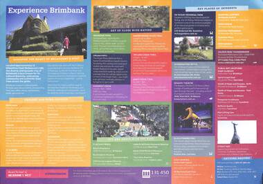
Poster - Experience Brimbank Poster
... Albans Square, Kangaroo Sculpture Matthews Hill, Reflexio Qualis sculptures Sunshine Bus Interchange and City Place, Man Lifting Cow Hampshire Rd Two sided poster with map of Brimbank on front and detailed description of key places of interest on back Poster Experience Brimbank Poster ...Poster produced by the City of BrimbankExperience Brimbank|Explore town centres of Deer Park, Keilor, St. Albans, Sunshine & Sydenham|Get up close with nature - Brimbank Park, Maribyrnong River Trail, Organ Pipes, Taylors Creek Trail, Kororoit Creek & Jones Creek Trail|Out and about with the kids - Alice's Playspace, Buckingham Reserve, Cliff Harvey Lagoon Reserve, Isabella Williams Memorial Reserve, Kevin Flint Memorial Reserve & The Lakes Reserve|Key places of interest - H.V. McKay Memorial Park, Overnewton Castle, Bowery Theatre, Black Powder Mill, Keilor Golf Course, Mt. Derrimut Golf Club, Brimbank Cente Shopping Centre, Keilor Central Shopping Centre, Sunshine Marketplace Shopping Centre, Sunshine Plaza Shopping Centre, Watergardens Shopping Centre, Clader Park Thunderdome|Public Art locations - Eagle sculpture Federation Trail Brooklyn, Spiral Graph Seat Lennon Parkway Derrimut, Seeds of Hope and Dreams Drift Alfredia St, Seeds of Hope and Dreams Yam Daisy St. Albans Square, Kangaroo Sculpture Matthews Hill, Reflexio Qualis sculptures Sunshine Bus Interchange and City Place, Man Lifting Cow Hampshire Rdbrimbank -
 Sunshine and District Historical Society Incorporated
Book - Cruden's Concordance Complete with proper names to the New and Old Testaments, unknown
... Bible Prayer Book City of Sunshine: This book was presented to the library by Amy and Bill Richards in memory of G R Crick MLA Green cover black vertical and diagonal lines on front and back covers. Spine with black lines and gold lettering. Faded colour edging. Coloured maps ...Green cover black vertical and diagonal lines on front and back covers. Spine with black lines and gold lettering. Faded colour edging. Coloured maps at the start of the book.bible, prayer book -
 Sunshine and District Historical Society Incorporated
Map - City of Sunshine Boundaries 1994 Maps
... 4 maps (wall) depicting the City of Sunshine Boundaries...City of Sunshine Boundaries 1991 wall maps...City of Sunshine City of Sunshine Boundaries 1991 wall maps 4 maps (wall) depicting the City of Sunshine Boundaries Map City of Sunshine Boundaries 1994 Maps ...City of Sunshine Boundaries 1991 wall mapscity of sunshine -
 Sunshine and District Historical Society Incorporated
Archive - Sunshine Heritage Panel Signs
... Newspaper Article August 2003 Trust warms of history crunch time|Letter 26 June 1996 from ICI Australia David Meale regarding a Heritage panel for Hunt Club Hotel|Photocopy of photograph Swimming Bath State School Sunshine|Handwritten Notes Old Town Hall|Handwritten Notes Parson and Lewis|Handwritten Notes Wright and Edwards|Handwritten Notes sunshine Technical School HV McKay donated 4 and half acres of land and 2000 pounds Mr HV McKay was chairman of the school council until his death in 1926 An innovation by HV McKay was the progressive move to allow his apprentices to attend day time classes 1922 a girls school was added with an initial enrollment of 33 girls|Handwritten Notes Swimming Pool|Newspaper Article The Sunshine Town Hall 21 May 1960|Photocopy of aerial photograph of Sunshine Station Precinct|Photocopy of photograph of Train Wagon|Photocopy of photograph of Train Carriage|Photocopy of photograph of Sunshine Technical College|Photocopy of photograph of Parsons and Lewis Horsehair Drawers and Curlers|Photocopy of photograph of Swimming Pool|Newspaper Article Municipal Chambers and Public Hall Hampshire Road|Printed Report Financial Details of Project for which you are requesting funds Anticipated cost of project $8905 7 Panels|Newspaper Article The Leader 31 August 1907 HV McKays Sunshine ahrvester Works at Sunshine Braybrook Junction|Photocopy of photograph The old Braybrook Hotel Ballarat road about 1954|Photocopy of photograph First Shire hall at Deer Park erected 1885|Photocopy of photograph Gunns Braybrook Hotel|Newspaper Article The Advocate 8 May 1996 Preserving our History Mr Norm Carlton and Ross MacKenzie unveil the plaque displaying the history behind the old town hall|Planning Permit Application No 96/228 Dated 18 June 1996 for Signs 5 Heritage Panels in Sunshine|Newspaper Article Brimbank Independent 7 May 1996 Marking time|Typed Report Texts for Heritage Panels 1995 Parsons and Lewis Old Town Hall Wright and Edwards Sunshine Technical school Kororoit Creek Swimming Pool|Photocopy of photograph Happy Children at the Swimming Pool Kororoit Creek|Drawings for Planning Permit 2 May 1996|Photocopy of photographs for consideration Parsons and Lewis Factory Man with Jugs Bill Hyetts Home First Avenue Sunshine Railway Accident Sunshine Group photograph and 24 men Sunshine FC 1932 Railways Lines with Manures on side of roof|Typed Letter from Joan Welsh to Norm Carlton listing possible sites for heritage signs Powder Magazine Humes Site Essendon Rowing Club Spongs Hotel Anglers Hotel 1862 Nelsons Boat Shed Swimming Site Maribyrnong Solomons Clancys Ford Rocks Across Trestle Bridge|Extract from The Victorian ailways Magazine September 1927 Bridge building in Excelsis By Chas H Perrin Chief Engineer for Railway Construction and two photographs of bridge getting built|Typed Letter from Joan Welsh Friends of the Maribyrnong Valey to Norm Carlton 26 November 1992 with heritage sign sites for City of Footscray City of Sunshine City of Keilor City of Essendon|Text for Panel Angling Match at Raleighs Punt 1866 and Photocopy of photograph|Text for Panel Castle and Meat Works 1868|Handwritten Letter 21 February 1993 From Joan Welsh to Norm Carlton|Handwritten notes and Photocopy of photograph|Quotation from Scott Williams Signs and Designs for $1430 each|Typed Letter 21 April 1993 to City Of Sunshine Planning for the HV McKay Industrial Site|Booklet Sunshine Heritage Tour|Letter 27 February 1991 to Schools Re Sunshine Heritage Panels including Booklet Sunshine Heritage Tour|Handwritten Notes 6 June 1990|Pamphlet Swan Hill Heritage Walk|Handwritten Notes Booklet Numbers and costs|Typed Notes Aborigianl Heritage William Barak|Handwritten Letter 27 June 1990 Photostory Pty Ltd William Barak and Children|Typed Letter 9 November 1989 to Sunshine and District Historical Society|Typed Lettter 9 February 1989 to City of Sunshine Heritage Panels quotesat $2250 each Photostory|Handwritten estimate 9 May 1988 Barry Searle Photographs|Typed Letter 1 March 1989 to Photostory placing order for 7 heritage panels at $2100 each|Handwritten Note about Funds|Typed Letter 20 November 1988 Sites for Heritage Panels|Typed Letter 27 July 1987 from Sunshine Community Committee BiCentennary 1988|Handwritten Notes|Brochure Bring Your History to Life|Map for sites|Typed Notes for Kororoit Creek Swimming Pool Heritage Panel Number 8|Handwritten Notes|Application for Planning Permit Blank|Typed Notes Unveiling of Heritage Panels|Handwritten Notes|Typed Letter 28 November 1994 from Photostory Quotation|Typed Notes Texts for Heritage Panels 1995|Photographs and Negatives for Heritage Panels|Typed Letter 18 October 1995 Map of Sunshine and district|Typed Letter 3 November 1995 5 additional heritage panels Kororoit Creek Swimming Pool The Old Town Hall Sunshine Technical school Parsons and Lewis Horse Hair factory Wright and Edwards Railway Carriage Works|Typed Notes Wright and Edwards|Typed Notes Old Town Hall|Typed Notes Sunshine Technical School|Typed Notes Parsons and Lewis|Typed Notes Kororoit Creek Swimming Pool|Maps You are at Panel Number|Typed Notes Places of Interest in the City of Sunshine|Handwritten Notes for 5 additional heritage panels|Booklet The History of the Land Discovery Trail|Extract from Municipal Directory Braybrook Shire|Programme 1994 General Meeting Pipemakers Park 10 March 1994|Typed Notes Financial Details of Project for which you are requesting funds|Sunshine Heritagte Tour|Flyer Western Ring Road Information bulletin No 10|Newspaper Article The Conservation Gazette April May 1996|Flyer Your History Mate The work of a community museum in Melbournes Western suburbs by Peter Haffenden|Brochure compulsory competitive Tendering|Heritage Panels Condition Review 2025 by Kerry Hewson...Newspaper Article August 2003 Trust warms of history crunch time|Letter 26 June 1996 from ICI Australia David Meale regarding a Heritage panel for Hunt Club Hotel|Photocopy of photograph Swimming Bath State School Sunshine|Handwritten Notes Old Town Hall|Handwritten Notes Parson and Lewis|Handwritten Notes Wright and Edwards|Handwritten Notes sunshine Technical School HV McKay donated 4 and half acres of land and 2000 pounds Mr HV McKay was chairman of the school council until his death in 1926 An innovation by HV McKay was the progressive move to allow his apprentices to attend day time classes 1922 a girls school was added with an initial enrollment of 33 girls|Handwritten Notes Swimming Pool|Newspaper Article The Sunshine Town Hall 21 May 1960|Photocopy of aerial photograph of Sunshine Station Precinct|Photocopy of photograph of Train Wagon|Photocopy of photograph of Train Carriage|Photocopy of photograph of Sunshine Technical College|Photocopy of photograph of Parsons and Lewis Horsehair Drawers and Curlers|Photocopy of photograph of Swimming Pool|Newspaper Article Municipal Chambers and Public Hall Hampshire Road|Printed Report Financial Details of Project for which you are requesting funds Anticipated cost of project $8905 7 Panels|Newspaper Article The Leader 31 August 1907 HV McKays Sunshine ahrvester Works at Sunshine Braybrook Junction|Photocopy of photograph The old Braybrook Hotel Ballarat road about 1954|Photocopy of photograph First Shire hall at Deer Park erected 1885|Photocopy of photograph Gunns Braybrook Hotel|Newspaper Article The Advocate 8 May 1996 Preserving our History Mr Norm Carlton and Ross MacKenzie unveil the plaque displaying the history behind the old town hall|Planning Permit Application No 96/228 Dated 18 June 1996 for Signs 5 Heritage Panels in Sunshine|Newspaper Article Brimbank Independent 7 May 1996 Marking time|Typed Report Texts for Heritage Panels 1995 Parsons and Lewis Old Town Hall Wright and Edwards Sunshine Technical school Kororoit Creek Swimming Pool|Photocopy of photograph Happy Children at the Swimming Pool Kororoit Creek|Drawings for Planning Permit 2 May 1996|Photocopy of photographs for consideration Parsons and Lewis Factory Man with Jugs Bill Hyetts Home First Avenue Sunshine Railway Accident Sunshine Group photograph and 24 men Sunshine FC 1932 Railways Lines with Manures on side of roof|Typed Letter from Joan Welsh to Norm Carlton listing possible sites for heritage signs Powder Magazine Humes Site Essendon Rowing Club Spongs Hotel Anglers Hotel 1862 Nelsons Boat Shed Swimming Site Maribyrnong Solomons Clancys Ford Rocks Across Trestle Bridge|Extract from The Victorian ailways Magazine September 1927 Bridge building in Excelsis By Chas H Perrin Chief Engineer for Railway Construction and two photographs of bridge getting built|Typed Letter from Joan Welsh Friends of the Maribyrnong Valey to Norm Carlton 26 November 1992 with heritage sign sites for City of Footscray City of Sunshine City of Keilor City of Essendon|Text for Panel Angling Match at Raleighs Punt 1866 and Photocopy of photograph|Text for Panel Castle and Meat Works 1868|Handwritten Letter 21 February 1993 From Joan Welsh to Norm Carlton|Handwritten notes and Photocopy of photograph|Quotation from Scott Williams Signs and Designs for $1430 each|Typed Letter 21 April 1993 to City Of Sunshine Planning for the HV McKay Industrial Site|Booklet Sunshine Heritage Tour|Letter 27 February 1991 to Schools Re Sunshine Heritage Panels including Booklet Sunshine Heritage Tour|Handwritten Notes 6 June 1990|Pamphlet Swan Hill Heritage Walk|Handwritten Notes Booklet Numbers and costs|Typed Notes Aborigianl Heritage William Barak|Handwritten Letter 27 June 1990 Photostory Pty Ltd William Barak and Children|Typed Letter 9 November 1989 to Sunshine and District Historical Society|Typed Lettter 9 February 1989 to City of Sunshine Heritage Panels quotesat $2250 each Photostory|Handwritten estimate 9 May 1988 Barry Searle Photographs|Typed Letter 1 March 1989 to Photostory placing order for 7 heritage panels at $2100 each|Handwritten Note about Funds|Typed Letter 20 November 1988 Sites for Heritage Panels|Typed Letter 27 July 1987 from Sunshine Community Committee BiCentennary 1988|Handwritten Notes|Brochure Bring Your History to Life|Map for sites|Typed Notes for Kororoit Creek Swimming Pool Heritage Panel Number 8|Handwritten Notes|Application for Planning Permit Blank|Typed Notes Unveiling of Heritage Panels|Handwritten Notes|Typed Letter 28 November 1994 from Photostory Quotation|Typed Notes Texts for Heritage Panels 1995|Photographs and Negatives for Heritage Panels|Typed Letter 18 October 1995 Map of Sunshine and district|Typed Letter 3 November 1995 5 additional heritage panels Kororoit Creek Swimming Pool The Old Town Hall Sunshine Technical school Parsons and Lewis Horse Hair factory Wright and Edwards Railway Carriage Works|Typed Notes Wright and Edwards|Typed Notes Old Town Hall|Typed Notes Sunshine Technical School|Typed Notes Parsons and Lewis|Typed Notes Kororoit Creek Swimming Pool|Maps You are at Panel Number|Typed Notes Places of Interest in the City of Sunshine|Handwritten Notes for 5 additional heritage panels|Booklet The History of the Land Discovery Trail|Extract from Municipal Directory Braybrook Shire|Programme 1994 General Meeting Pipemakers Park 10 March 1994|Typed Notes Financial Details of Project for which you are requesting funds|Sunshine Heritagte Tour|Flyer Western Ring Road Information bulletin No 10|Newspaper Article The Conservation Gazette April May 1996|Flyer Your History Mate The work of a community museum in Melbournes Western suburbs by Peter Haffenden|Brochure compulsory competitive Tendering|Heritage Panels Condition Review 2025 by Kerry Hewson Collection of information on the Sunshine Heritage Panel Signs Archive Sunshine Heritage Panel Signs ...Newspaper Article August 2003 Trust warms of history crunch time|Letter 26 June 1996 from ICI Australia David Meale regarding a Heritage panel for Hunt Club Hotel|Photocopy of photograph Swimming Bath State School Sunshine|Handwritten Notes Old Town Hall|Handwritten Notes Parson and Lewis|Handwritten Notes Wright and Edwards|Handwritten Notes sunshine Technical School HV McKay donated 4 and half acres of land and 2000 pounds Mr HV McKay was chairman of the school council until his death in 1926 An innovation by HV McKay was the progressive move to allow his apprentices to attend day time classes 1922 a girls school was added with an initial enrollment of 33 girls|Handwritten Notes Swimming Pool|Newspaper Article The Sunshine Town Hall 21 May 1960|Photocopy of aerial photograph of Sunshine Station Precinct|Photocopy of photograph of Train Wagon|Photocopy of photograph of Train Carriage|Photocopy of photograph of Sunshine Technical College|Photocopy of photograph of Parsons and Lewis Horsehair Drawers and Curlers|Photocopy of photograph of Swimming Pool|Newspaper Article Municipal Chambers and Public Hall Hampshire Road|Printed Report Financial Details of Project for which you are requesting funds Anticipated cost of project $8905 7 Panels|Newspaper Article The Leader 31 August 1907 HV McKays Sunshine ahrvester Works at Sunshine Braybrook Junction|Photocopy of photograph The old Braybrook Hotel Ballarat road about 1954|Photocopy of photograph First Shire hall at Deer Park erected 1885|Photocopy of photograph Gunns Braybrook Hotel|Newspaper Article The Advocate 8 May 1996 Preserving our History Mr Norm Carlton and Ross MacKenzie unveil the plaque displaying the history behind the old town hall|Planning Permit Application No 96/228 Dated 18 June 1996 for Signs 5 Heritage Panels in Sunshine|Newspaper Article Brimbank Independent 7 May 1996 Marking time|Typed Report Texts for Heritage Panels 1995 Parsons and Lewis Old Town Hall Wright and Edwards Sunshine Technical school Kororoit Creek Swimming Pool|Photocopy of photograph Happy Children at the Swimming Pool Kororoit Creek|Drawings for Planning Permit 2 May 1996|Photocopy of photographs for consideration Parsons and Lewis Factory Man with Jugs Bill Hyetts Home First Avenue Sunshine Railway Accident Sunshine Group photograph and 24 men Sunshine FC 1932 Railways Lines with Manures on side of roof|Typed Letter from Joan Welsh to Norm Carlton listing possible sites for heritage signs Powder Magazine Humes Site Essendon Rowing Club Spongs Hotel Anglers Hotel 1862 Nelsons Boat Shed Swimming Site Maribyrnong Solomons Clancys Ford Rocks Across Trestle Bridge|Extract from The Victorian ailways Magazine September 1927 Bridge building in Excelsis By Chas H Perrin Chief Engineer for Railway Construction and two photographs of bridge getting built|Typed Letter from Joan Welsh Friends of the Maribyrnong Valey to Norm Carlton 26 November 1992 with heritage sign sites for City of Footscray City of Sunshine City of Keilor City of Essendon|Text for Panel Angling Match at Raleighs Punt 1866 and Photocopy of photograph|Text for Panel Castle and Meat Works 1868|Handwritten Letter 21 February 1993 From Joan Welsh to Norm Carlton|Handwritten notes and Photocopy of photograph|Quotation from Scott Williams Signs and Designs for $1430 each|Typed Letter 21 April 1993 to City Of Sunshine Planning for the HV McKay Industrial Site|Booklet Sunshine Heritage Tour|Letter 27 February 1991 to Schools Re Sunshine Heritage Panels including Booklet Sunshine Heritage Tour|Handwritten Notes 6 June 1990|Pamphlet Swan Hill Heritage Walk|Handwritten Notes Booklet Numbers and costs|Typed Notes Aborigianl Heritage William Barak|Handwritten Letter 27 June 1990 Photostory Pty Ltd William Barak and Children|Typed Letter 9 November 1989 to Sunshine and District Historical Society|Typed Lettter 9 February 1989 to City of Sunshine Heritage Panels quotesat $2250 each Photostory|Handwritten estimate 9 May 1988 Barry Searle Photographs|Typed Letter 1 March 1989 to Photostory placing order for 7 heritage panels at $2100 each|Handwritten Note about Funds|Typed Letter 20 November 1988 Sites for Heritage Panels|Typed Letter 27 July 1987 from Sunshine Community Committee BiCentennary 1988|Handwritten Notes|Brochure Bring Your History to Life|Map for sites|Typed Notes for Kororoit Creek Swimming Pool Heritage Panel Number 8|Handwritten Notes|Application for Planning Permit Blank|Typed Notes Unveiling of Heritage Panels|Handwritten Notes|Typed Letter 28 November 1994 from Photostory Quotation|Typed Notes Texts for Heritage Panels 1995|Photographs and Negatives for Heritage Panels|Typed Letter 18 October 1995 Map of Sunshine and district|Typed Letter 3 November 1995 5 additional heritage panels Kororoit Creek Swimming Pool The Old Town Hall Sunshine Technical school Parsons and Lewis Horse Hair factory Wright and Edwards Railway Carriage Works|Typed Notes Wright and Edwards|Typed Notes Old Town Hall|Typed Notes Sunshine Technical School|Typed Notes Parsons and Lewis|Typed Notes Kororoit Creek Swimming Pool|Maps You are at Panel Number|Typed Notes Places of Interest in the City of Sunshine|Handwritten Notes for 5 additional heritage panels|Booklet The History of the Land Discovery Trail|Extract from Municipal Directory Braybrook Shire|Programme 1994 General Meeting Pipemakers Park 10 March 1994|Typed Notes Financial Details of Project for which you are requesting funds|Sunshine Heritagte Tour|Flyer Western Ring Road Information bulletin No 10|Newspaper Article The Conservation Gazette April May 1996|Flyer Your History Mate The work of a community museum in Melbournes Western suburbs by Peter Haffenden|Brochure compulsory competitive Tendering|Heritage Panels Condition Review 2025 by Kerry Hewson -
 Sunshine and District Historical Society Incorporated
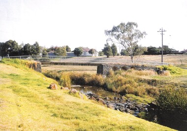
Photograph - Footbridge over Kororoit Creek Yallourn Street to Ballarat Road Ardeer, Johnson, Des, 7 Nov., 1988
... 1 to 6 This square blue stone foot bidge was originated by Norm stores of Derrimut Street Albion who was a Road engineer for Sunshine City Council between Yallourn Street and Sun Hill Crescent and Ballarat Road Ardeer C 1953 to 1954 Melway Map 26 B9...Donated to S&DHS Kororoit Creek Ardeer Bridge 1 to 6 This square blue stone foot bidge was originated by Norm stores of Derrimut Street Albion who was a Road engineer for Sunshine City Council between Yallourn Street and Sun Hill Crescent and Ballarat Road Ardeer C 1953 to 1954 Melway Map 26 B9 Footbridge over Kororoit Creek from Yallourn Street Ardeer to Ballarat Road Albion constructed 1953 to 1954 under the supervision of City Of Sunshine Road Engineer Norm Stores of Albion Photograph Footbridge over Kororoit Creek Yallourn Street to Ballarat Road Ardeer Johnson, Des. ...Donated to S&DHS1 to 6 This square blue stone foot bidge was originated by Norm stores of Derrimut Street Albion who was a Road engineer for Sunshine City Council between Yallourn Street and Sun Hill Crescent and Ballarat Road Ardeer C 1953 to 1954 Melway Map 26 B9kororoit creek, ardeer, bridge