Showing 80 items matching "civic maps"
-
 Whitehorse Historical Society Inc.
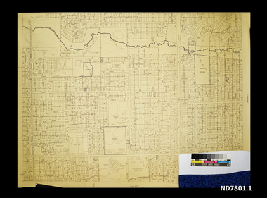
Map - Civic maps, City of Nunawading, City of Nunawading Maps
... Civic maps......Civic maps...Scale 1:2500 City of Nunawading Maps Map Civic maps City of Nunawading ...A collection of maps of the City of Nunawading from Diana Coles, City of Whitehorse Community Chest.8 printed maps of various sizes covering city of Nunawading. Scale 1:2500non-fictionA collection of maps of the City of Nunawading from Diana Coles, City of Whitehorse Community Chest. coles diana, civic maps, city of nunawading, whitehorse road, blackburn road -
 Whitehorse Historical Society Inc.
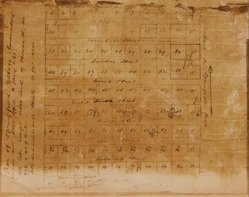
Map - Civic Map, Subdivision of Village of Springfield, 1861
... Civic Map...Historical civic map of the Nunawading area....Subdivision of Village of Springfield Map Civic Map ...Map of the subdivision of the Springfield Estate, Nunawading, 1861. The Springfield Estate was located in the Northwest corner of Whitehorse Road and Springvale Road.Map of the subdivision of the Springfield Estate, Nunawading, 1861. Springfield Estate was located in the Northwest corner of Whitehorse Road and Springvale Road.non-fictionMap of the subdivision of the Springfield Estate, Nunawading, 1861. The Springfield Estate was located in the Northwest corner of Whitehorse Road and Springvale Road.springfield estate, whitehorse road nunawading, springvale road nunawading -
 Narre Warren and District Family History Group
Book, Narre Warren & District Family History Group Inc, Casey Cardinia Collection - Berwick Information File - Volume 2, 2021
... The date the articles were published, and title of articles are listed below. 25 Sep 2000 History Dying for Lack of Museum 22 Oct 1992 Berwick’s Churches Took Pride of Place 13 May 2009 Lex Loves the Groundwork - Wilson Botanic Park 28 Mar 2012 To Hell and Back - Julie Cini 12 Oct 2016 Church Pillar Jim - Jim Allan 27 May 2015 Pillar of College - John Waterhouse 2 Dec 2015 Dressed for Success - Rosalie Ham & Sue Maslin 9 Nov 2016 A Man Who Remembered - Cyril Molyneux 21 Sep 2011 Honour for History Sisters - Sonia Beaumont & Louise Reeve 11 Oct 2017 Berwick’s Back to its Roots UNKNOWN City’s Volunteers Entertained 16 Apr 2008 Cooking up Memories - Olive Foy 16 Sep 2013 Historic Site Faces Carve-up - Kilkirean 16 Sep 2021 Appropriate Residence for Such Prominent Residents - Wilsons 27 May 1993 Edrington, Home of Lord and Lady Casey UNKNOWN Burnbank UNKNOWN Beaumont Road Property UNKNOWN Edrington Park - pamphlet UNKNOWN Edrington Park - plan, trees & past owners 12 Oct 2016 Final Course at Clover - Clover Cottage UNKNOWN Burr Hill - sale 27 Oct 2003 People Power Acts for Posterity - Old Berwick Primary School 11 Oct 2000 School is Historic Site - Old Berwick Primary School 6 Nov 2003 Community Icon Will be Missed - George Wilson 1 Nov 2000 Plea on School Site - Old Berwick Primary School 8 Nov 2000 College to Push for Site - Old Berwick Primary School 27 Sep 2000 Stand up for Berwick - Old Berwick Primary School 27 Sep 2000 Village People - Old Berwick Primary School 11 Nov 2003 Park Feedback Quest - Old Berwick Primary School 5 Nov 2003 Berwick Village Town Park Concept UNKNOWN Berwick Mechanics Institute and Free Library - pamphlet 23 Jul 1993 Where to Build the New City’s Civic Centre? UNKNOWN Berwick map 12 Mar 2008 The Other Millers’ Tale - John & Brenda Miller 11 Jun 2008 Breeding a Class of Their Own - Allan & Jill Furborough 13 Jan 2010 Dawn’s Work Will Go On - Dawn Dorning 5 Aug 2009 Members Remember - Red Cross 17 Jun 2009 Diamond Couple are the Best of Friends - Hugh & Dorothy Hodson 25 Nov 2009 Century of Community Care - St John of God Hospital 7 Sep 2016 Farewell to a Dynamic Lady - Jan Bateman 13 May 2009 Diamond Couple - Bill & Joyce Minns 11 Jul 2013 Short Memory - Proposed site for Cultural Centre 21 Apr 2021 Memories of Afghanistan - Chris May 16 Jun 2021 Survivor is a Guiding Light - Kay Rankin 25 Aug 2021 Mixing with the Famous - Lord & Lady Casey 21 May 2015 Happy Couple’s Life of “Bliss and Hiss” - Val & John Evans 15 Jun 2016 Last Orders? ...The date the articles were published, and title of articles are listed below. 25 Sep 2000 History Dying for Lack of Museum 22 Oct 1992 Berwick’s Churches Took Pride of Place 13 May 2009 Lex Loves the Groundwork - Wilson Botanic Park 28 Mar 2012 To Hell and Back - Julie Cini 12 Oct 2016 Church Pillar Jim - Jim Allan 27 May 2015 Pillar of College - John Waterhouse 2 Dec 2015 Dressed for Success - Rosalie Ham & Sue Maslin 9 Nov 2016 A Man Who Remembered - Cyril Molyneux 21 Sep 2011 Honour for History Sisters - Sonia Beaumont & Louise Reeve 11 Oct 2017 Berwick’s Back to its Roots UNKNOWN City’s Volunteers Entertained 16 Apr 2008 Cooking up Memories - Olive Foy 16 Sep 2013 Historic Site Faces Carve-up - Kilkirean 16 Sep 2021 Appropriate Residence for Such Prominent Residents - Wilsons 27 May 1993 Edrington, Home of Lord and Lady Casey UNKNOWN Burnbank UNKNOWN Beaumont Road Property UNKNOWN Edrington Park - pamphlet UNKNOWN Edrington Park - plan, trees & past owners 12 Oct 2016 Final Course at Clover - Clover Cottage UNKNOWN Burr Hill - sale 27 Oct 2003 People Power Acts for Posterity - Old Berwick Primary School 11 Oct 2000 School is Historic Site - Old Berwick Primary School 6 Nov 2003 Community Icon Will be Missed - George Wilson 1 Nov 2000 Plea on School Site - Old Berwick Primary School 8 Nov 2000 College to Push for Site - Old Berwick Primary School 27 Sep 2000 Stand up for Berwick - Old Berwick Primary School 27 Sep 2000 Village People - Old Berwick Primary School 11 Nov 2003 Park Feedback Quest - Old Berwick Primary School 5 Nov 2003 Berwick Village Town Park Concept UNKNOWN Berwick Mechanics Institute and Free Library - pamphlet 23 Jul 1993 Where to Build the New City’s Civic Centre? UNKNOWN Berwick map 12 Mar 2008 The Other Millers’ Tale - John & Brenda Miller 11 Jun 2008 Breeding a Class of Their Own - Allan & Jill Furborough 13 Jan 2010 Dawn’s Work Will Go On - Dawn Dorning 5 Aug 2009 Members Remember - Red Cross 17 Jun 2009 Diamond Couple are the Best of Friends - Hugh & Dorothy Hodson 25 Nov 2009 Century of Community Care - St John of God Hospital 7 Sep 2016 Farewell to a Dynamic Lady - Jan Bateman 13 May 2009 Diamond Couple - Bill & Joyce Minns 11 Jul 2013 Short Memory - Proposed site for Cultural Centre 21 Apr 2021 Memories of Afghanistan - Chris May 16 Jun 2021 Survivor is a Guiding Light - Kay Rankin 25 Aug 2021 Mixing with the Famous - Lord & Lady Casey 21 May 2015 Happy Couple’s Life of “Bliss and Hiss” - Val & John Evans 15 Jun 2016 Last Orders? ...Folder containing a table of contents and various newspaper clippings and other information pertaining to the Berwick area Volume 2. The date the articles were published, and title of articles are listed below. 25 Sep 2000 History Dying for Lack of Museum 22 Oct 1992 Berwick’s Churches Took Pride of Place 13 May 2009 Lex Loves the Groundwork - Wilson Botanic Park 28 Mar 2012 To Hell and Back - Julie Cini 12 Oct 2016 Church Pillar Jim - Jim Allan 27 May 2015 Pillar of College - John Waterhouse 2 Dec 2015 Dressed for Success - Rosalie Ham & Sue Maslin 9 Nov 2016 A Man Who Remembered - Cyril Molyneux 21 Sep 2011 Honour for History Sisters - Sonia Beaumont & Louise Reeve 11 Oct 2017 Berwick’s Back to its Roots UNKNOWN City’s Volunteers Entertained 16 Apr 2008 Cooking up Memories - Olive Foy 16 Sep 2013 Historic Site Faces Carve-up - Kilkirean 16 Sep 2021 Appropriate Residence for Such Prominent Residents - Wilsons 27 May 1993 Edrington, Home of Lord and Lady Casey UNKNOWN Burnbank UNKNOWN Beaumont Road Property UNKNOWN Edrington Park - pamphlet UNKNOWN Edrington Park - plan, trees & past owners 12 Oct 2016 Final Course at Clover - Clover Cottage UNKNOWN Burr Hill - sale 27 Oct 2003 People Power Acts for Posterity - Old Berwick Primary School 11 Oct 2000 School is Historic Site - Old Berwick Primary School 6 Nov 2003 Community Icon Will be Missed - George Wilson 1 Nov 2000 Plea on School Site - Old Berwick Primary School 8 Nov 2000 College to Push for Site - Old Berwick Primary School 27 Sep 2000 Stand up for Berwick - Old Berwick Primary School 27 Sep 2000 Village People - Old Berwick Primary School 11 Nov 2003 Park Feedback Quest - Old Berwick Primary School 5 Nov 2003 Berwick Village Town Park Concept UNKNOWN Berwick Mechanics Institute and Free Library - pamphlet 23 Jul 1993 Where to Build the New City’s Civic Centre? UNKNOWN Berwick map 12 Mar 2008 The Other Millers’ Tale - John & Brenda Miller 11 Jun 2008 Breeding a Class of Their Own - Allan & Jill Furborough 13 Jan 2010 Dawn’s Work Will Go On - Dawn Dorning 5 Aug 2009 Members Remember - Red Cross 17 Jun 2009 Diamond Couple are the Best of Friends - Hugh & Dorothy Hodson 25 Nov 2009 Century of Community Care - St John of God Hospital 7 Sep 2016 Farewell to a Dynamic Lady - Jan Bateman 13 May 2009 Diamond Couple - Bill & Joyce Minns 11 Jul 2013 Short Memory - Proposed site for Cultural Centre 21 Apr 2021 Memories of Afghanistan - Chris May 16 Jun 2021 Survivor is a Guiding Light - Kay Rankin 25 Aug 2021 Mixing with the Famous - Lord & Lady Casey 21 May 2015 Happy Couple’s Life of “Bliss and Hiss” - Val & John Evans 15 Jun 2016 Last Orders? Not for Carl - Carl Strachan 20 Oct 2021 Settling the Soldiers - Soldiers Road 28 Jan 2009 Secrets Behind the Show - Berwick Show 24 Jan 2018 Club in a Gesture for Jim - Jim Allan 21 Feb 2018 Shipwreck Lovers Settle in Berwick, Despite Cannibals 14 Aug 2013 Association Members Celebrate Their 80th - Red Cross 24 Feb 2021 Cheese Factory’s Rich Past 10 Jun 2020 Kempson Left His Mark - Henry Kempson 10 Mar 2021 School Began on Holidays - St Margarets 25 Aug 2021 The Sweet Side of Savory - Gil Savory 25 Jul 2018 Firing up the Old Brigade - 11 Jul 2018 Tribute to the Good Doctor - Percy Langmore 25 Apr 2018 A Brush with History 25 Apr 2018 Looking Back 9 Feb 2009 A Place in History - Living Memories DVD 25 Oct 2017 Founding Family Continues Show’s Style - Dandenong Show 19 Mar 2015 United by News - Bill Rogers 1 Feb 2017 Ruth in Heritage Honour - Ruth Crofts 23 Aug 2017 Athlete was a Gentleman - Edwin Flack 23 Aug 2017 Historic News in Brief UNKNOWN Playing the Part - World Wars Re-enactment 9 Jul 2014 Building on Some Historic Foundations - National Trust 26 Apr 2018 Big Crowd for First Dawn 16 Apr 2007 Life and Legacy Remembered - Peter Canobio 25 Jun 2008 Walking Tour Unearths “Jewels” - Hands on History Tour CD 12 Dec 2007 Old Cheese Factory was Built by Sir William Clarke in 1875 31 Mar 2021 Cemetery Extension Open - Berwick Cemetery 31 Mar 2021 End of an Era: Don Retiring from Trust After 40 Years - Don Moyes 7 Feb 2018 A Healthy History in Berwick - St John of God Hospital 18 Apr 2018 Hollywood in Berwick - On the Beach 30 Apr 2014 More Than a Token Effort - Cyril Molyneux 25 Apr 2018 Dedicated to Their Valour - Victoria Cross 13 Apr 2016 After 49 Years, the Final Snip - Les Jones 12 Nov 2007 A Proud History Building a Strong Future - St John of God 8 Nov 2017 Army Medic Takes the Highest Road - Samantha Bradbury 8 Nov 2017 War Memorial Set in Stone 27 Jun 2016 Farewell and Thanks - Berwick Leader May 2008 Attracting Some Flack - National Sports Museum 21 Sep 2016 150 Years of Worship - Berwick Church of Christ 27 Apr 2016 Major is Guest Speaker 17 Nov 2021 Iconic Berwick Sale - Burr Hill 17 Nov 2021 A Legendary Contributor to Local Sport - Arch Brown 15 Dec 2021 Fascinating Family History - Kirkham family 16 Feb 2011 50 Years of Love - Vincent & Carmel Taranto 16 Feb 2011 Life Members on Show UNKNOWN Good Doctor Laid a Medical Foundation 27 Sep 2000 Citizen of the Century 25 Nov 2015 It’s the End of a CWA Era 21 Jan 2015 Rotunda Opens Up 23 Feb 2022 Avard and Sunnyside 9 Mar 2022 Dedicated Farming Family 16 Feb 2022 Heritage Protector Passes 10 Nov 2021 VC Hero’s Story Revealed 2 Nov 2022 Captain Chose the Name 7 Dec 2022 Battin for the People 21 Mar 2018 Marking Scanlan Street 7 Mar 2018 Funston a Fine Figure 22 Dec 2020 The Park Jack Helped Build 25 Nov 2020 Park Honours Pioneers 14 Oct 2020 Colourful Characters - McKay Family 2 Sep 2020 Mayor’s Prussian Heritage - Kirsty Lottkowitz 19 Aug 2020 A Generous Patriot 22 Jul 2020 The Grice Family Legacy 13 May 2020 Tea Baron’s Life on Clover 1 Apr 2020 Well Played Warnes 4 Mar 2020 Right Royal Name Change - Gloucester Avenue 22 Jan 2020 Four Generations Strong - Ward family 8 Aug 2018 Buchanans Make A Mark 27 Jun 2018 Integral to Berwick Life 2 May 2018 Storekeeper’s New Digs 13 Jul 2022 A Walk in the Park in 1992 19 Oct 2022 From Ireland to Berwick 7 Sep 2022 One for the History Books 12 Jul 2018 Berwick Set For Big 150th 13 Jul 2022 Lex’s Fascinating Legacy - Wilson Botanic Gardens 13 Jul 2022 From a Quarry to Gardens - Wilson Botanic Gardens 20 July 2022 WGCA Mourning the Loss of Wallace - Jeff Wallace 27 Apr 2022 First Female in 104 Years - Berwick RSL 29 Apr 2020 Fritzlaffs Strike Gold 27 Apr 2022 Marching for the Anzacsnon-fictionberwick (vic.) -
 Bendigo Military Museum
Memorabilia - PLAQUE WW2, Angus & Coote, Post WW2
... Bendigo Military Museum 37 - 39 Pall Mall Bendigo goldfields Lionel Younghusband NX115868, refer Cat No 2491P for service details. civic mementoes - plaques military history On metal scroll: “We Honour You” On shield: “For Service 1936-45” On blue metal: “Tullamore” On name plate: “In Memory of TPR L G Younghusband” Plague, made of black painted timber with silver coloured metal scroll on top & rectangular plate on bottom. In the centre is a round dome bearing a raised badge in silver coloured metal, surmounted by blue enamel map ...Lionel Younghusband NX115868, refer Cat No 2491P for service details.Plague, made of black painted timber with silver coloured metal scroll on top & rectangular plate on bottom. In the centre is a round dome bearing a raised badge in silver coloured metal, surmounted by blue enamel map of Australia. On bottom of badge is a plain banner with blue enamel.On metal scroll: “We Honour You” On shield: “For Service 1936-45” On blue metal: “Tullamore” On name plate: “In Memory of TPR L G Younghusband”civic mementoes - plaques, military history -
 Bendigo Military Museum
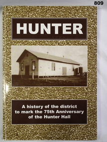
Book, Richard Cambridge, Hunter, 2002
... civic mementoes Handwritten in black ink on flyleaf - This Book contains sections on "Soldier Settlement - The War Years & VDC Units. Handwritten in blue ink on 2nd page: Norma Lovelace 26-10-2002. Soft card, cover, illustrated sepia photographs, white print on front and spine. HUNTER A History of the District to Mark the 75th Anniversary of The Hunter Hall. 171 pages, illustrated, black & white photographs, diagrams, maps ...Soft card, cover, illustrated sepia photographs, white print on front and spine. HUNTER A History of the District to Mark the 75th Anniversary of The Hunter Hall. 171 pages, illustrated, black & white photographs, diagrams, maps.Handwritten in black ink on flyleaf - This Book contains sections on "Soldier Settlement - The War Years & VDC Units. Handwritten in blue ink on 2nd page: Norma Lovelace 26-10-2002.books - military history / local history, civic mementoes -
 Glen Eira Historical Society
Document - NEERIM ROAD RAILWAY CROSSING AND GATES GLEN HUNTLY
... Advertisements Graphics Advertising Advertising Signs Signs Estate Agents Business People Stockdale and Leggo Buildings Structures and Establishments Occupations United Signs Signs Communication Devices Motor Vehicles Glenhuntly Railway Station Town Planning Civic and Landscape Art Engineers Professionals Traffic Road Transport Transport Maps Documents Plans Document NEERIM ROAD RAILWAY CROSSING AND GATES GLEN HUNTLY ...This file contains two items: 1/Twelve photographs of the Glen Huntly, Neerim Road hand-operated railway gates, dated 1983 and November 1985, photographer unknown, and two black and white copies of two of the original photographs. Four photographs are in black and white and eight are in colour, all picturing the Gatekeeper’s shelter and/or the railway gates. Six photographs dated 1985 include the Gatekeeper, unidentified, in some photos operating the gates. 2/A three-page pamphlet dated 03/05/1979 promoting a public meeting at the Caulfield Town Hall to debate Road Grade Separation proposals for the Neerim Road and Glenhuntly Road railway crossings. Document details the proposed VicRail improvement and four alternative improvements as we as a blank questionnaire for the submission of ideas regarding the proposals to the Caulfield City Council Urban Planner. A short summary of other concerns held by two councillors and an engineer regarding the proposal is also included, as is a Railway Noise Level. Railway Pamphlet also includes a map of the area surrounding the railway crossings under discussion 1977.glenhuntly road, neerim road, caulfield, railway gates, gates, hand-operated railway gates, railways, roads and streets, railway crossings, architectural features, town halls, official buildings, vicrail, meetings, public meetings, caulfield town hall, gatekeepers, caulfield city council, elsternwick, glen huntly, caulfield park, caulfield racecourse, normanby road, dandenong road, railway buildings, railway stations, land transport, transport establishments, hordern a.g., dunstan don, hordern bill, needham j.g., advertisements, graphics, advertising, advertising signs, signs, estate agents, business people, stockdale and leggo, buildings structures and establishments, occupations, united signs, signs, communication devices, motor vehicles, glenhuntly railway station, town planning, civic and landscape art, engineers, professionals, traffic, road transport, transport, maps, documents, plans -
 Glen Eira Historical Society
Article - Rosstown Railway
... map of the area surrounding the site of the mill. 3/Three photocopies of a black and white illustration of the Rosstown sugar works from the east, undated and artist unknown. Rosstown Rail Trail Rosstown Ross William Ross W. Murray Ross Murray Sugar Beet Mills Mills Elsternwick Land Transport Railways Railway Lines Railway Routes Carnegie Neville Street Carnegie Miller Street Factories Market Gardens Horticulture Peat Soils Land Forms Topography Geology Civic Issues Cone Sugar Industry Elsternwick Plaza Elsternwick Glenhuntly Road Parks and Reserves EE Gunn Reserve Caulfield Racecourse Sportsgrounds Caulfield Carnegie Riddell Parade Clarence Street Aileen Avenue Princes Park Dover Street Marara Road Oakleigh Road Rosanna Street Murrumbeena Crescent North Road Kooyong Road Hawthorn Road Booran Road Koornang Road Poath Road Warragul Road Railway Platforms Railway Buildings Bambra Road Swamps Landforms Landfill Council Landfill Railway Bridges Bridges Railway Underpasses Sporting Clubs Tennis Clubs Bowls Clubs Rosstown Railway Rosanna Street Reserve Maps Railway Maps LIVING IN GLEN EIRA Weickhardt Ian Jowett Des Caulfield South Curraweena Road Oakleigh Caulfield Technical School RETURN TO ROSSTOWN Beet Sugar Industry Crops Land Booms Land Development and Subdivisions Bent Thomas Fink Benjamin Sugar Works Rosstown Hotel Oamdenong Road ROSSTOWN DRY CLEANERS Shops Rosstown Road Rosstown Plate People by Circumstance Migrants Accountants Occupations Professionals THE GRANGE Real Estate Grange Road Financial Agents Judges ROSSTOWN ESTATE Financial Trouble Rabbit Preserving Breweries Political Debates Political Issues Political Electorates Politics Political Science Debt Financial Loans Court Procedures Court Cases Legal Events and Activities MALLESON AND RIGGALL Widowers SEABEACH RAILWAY Economics Economic Deadline Depression 1890s Economic Crash Mortgages Divorce Social Problems Poverty Ross Claude Ross Roderick World War 1914-1918 Wars Military History Servicemen AUSTRALIAN FLYING CORPS Engineers Caulfield Council Swagmen Homelessness Glenhuntly Road Glenhuntly Road Tram Woornack Road Leila Road Wild Cherry Road Melten Avenue Illustrations Steam Trains Trains Horse and Cart Horse-drawn Transport Railway Stations Article Rosstown Railway ...This file contains three items: 1/A review of the ROSSTOWN RAIL TRAIL from LIVING IN GLEN EIRA, vol. 11, 2004, Issue 4, no. 25, date and author unknown. The review explains the purpose of the Rail Trail with a brief narrative of the history behind Rosstown Sugar Mill Railway line. Concluding with information on the location of the Trail and the expected time required to walk the entire track included in the review is a map of the Rail Trail, which marks significant sites along the trail with historic pictures. 2/A newspaper article from THE AGE, dated Tuesday 21/10/1980 and written by Iola Matthews, reporting on the circumstances that led to the publication of the book RETURN TO ROSSTOWN written by Des Jowett and Ian Weickhardt. The article begins with a brief biography of the authors before moving into details of the book’s content, providing a further biography of W. Murray Ross which includes information on his financial ventures – particularly the Rosstown Rail – his marriage and children. The article includes a black and white photograph of Weickhardt and Jowett walking along the route of the railway line, an illustration of the Rosstown sugar works and a map of the area surrounding the site of the mill. 3/Three photocopies of a black and white illustration of the Rosstown sugar works from the east, undated and artist unknown.rosstown rail trail, rosstown, ross william, ross w. murray, ross murray, sugar beet mills, mills, elsternwick, land transport, railways, railway lines, railway routes, carnegie neville street, carnegie miller street, factories, market gardens, horticulture, peat, soils, land forms, topography, geology, civic issues, cone sugar industry, elsternwick plaza, elsternwick, glenhuntly road, parks and reserves, ee gunn reserve, caulfield racecourse, sportsgrounds, caulfield, carnegie, riddell parade, clarence street, aileen avenue, princes park, dover street, marara road, oakleigh road, rosanna street, murrumbeena crescent, north road, kooyong road, hawthorn road, booran road, koornang road, poath road, warragul road, railway platforms, railway buildings, bambra road, swamps, landforms, landfill, council landfill, railway bridges, bridges, railway underpasses, sporting clubs, tennis clubs, bowls clubs, rosstown railway, rosanna street reserve, maps, railway maps, living in glen eira, weickhardt ian, jowett des, caulfield south, curraweena road, oakleigh, caulfield technical school, return to rosstown, beet sugar industry, crops, land booms, land development and subdivisions, bent thomas, fink benjamin, sugar works, rosstown hotel, oamdenong road, rosstown dry cleaners, shops, rosstown road, rosstown plate, people by circumstance, migrants, accountants, occupations, professionals, the grange, real estate, grange road, financial agents, judges, rosstown estate, financial trouble, rabbit preserving, breweries, political debates, political issues, political electorates, politics, political science, debt, financial loans, court procedures, court cases, legal events and activities, malleson and riggall, widowers, seabeach railway, economics, economic deadline, depression 1890s, economic crash, mortgages, divorce, social problems, poverty, ross claude, ross roderick, world war 1914-1918, wars, military history, servicemen, australian flying corps, engineers, caulfield council, swagmen, homelessness, glenhuntly road, glenhuntly road tram, woornack road, leila road, wild cherry road, melten avenue, illustrations, steam trains, trains, horse and cart, horse-drawn transport, railway stations -
 Greensborough Historical Society
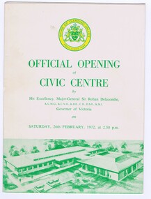
Memorabilia - Program, Shire of Diamond Valley, Official opening of Civic Centre 1972, 26/02/1972
... map of the building. Bruce Morgan was the first Shire Secretary (1964-1983) of the Shire of Diamond Valley. This collection was compiled by his wife, Mavis Morgan, detailing the events they attended in their official capacity bruce morgan mavis morgan shire of diamond valley diamond valley civic centre Tri-fold brochure on buff card with green text and logo. ...Program for the official opening of the new Council Chambers and Municipal Offices on 26th February 1972. The Offices were officially opened by Sir Rohan Delacombe, Governor of Victoria. Includes a brief history of the Shire of Diamond Valley, the meaning of the Shire logo and a map of the building.Bruce Morgan was the first Shire Secretary (1964-1983) of the Shire of Diamond Valley. This collection was compiled by his wife, Mavis Morgan, detailing the events they attended in their official capacityTri-fold brochure on buff card with green text and logo.bruce morgan, mavis morgan, shire of diamond valley, diamond valley civic centre -
 Greensborough Historical Society
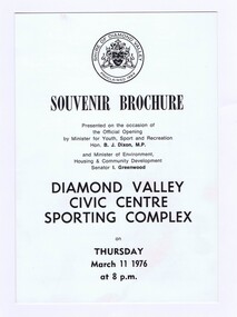
Memorabilia - Brochure, Shire of Diamond Valley, Diamond Valley Civic Centre Sporting Complex Souvenir Brochure on Thursday March 11 1976, 1976
... This collection was compiled by his wife, Mavis Morgan, detailing the events they attended in their official capacity bruce morgan mavis morgan Diamond Valley Civic Centre Sporting Complex Off white card with black text and drawn map Diamond Valley Civic Centre Sporting Complex Souvenir Brochure on Thursday March 11 1976 Memorabilia Brochure Shire of Diamond Valley ...Souvenir Brochure of the Opening of the Diamond Valley Civic Centre Sporting Complex with information, Sporting Complex Layout Plan, and day's programBruce Morgan was the first Shire Secretary (1964-1983) of the Shire of Diamond Valley. This collection was compiled by his wife, Mavis Morgan, detailing the events they attended in their official capacityOff white card with black text and drawn mapbruce morgan, mavis morgan, diamond valley civic centre sporting complex -
 Eltham District Historical Society Inc
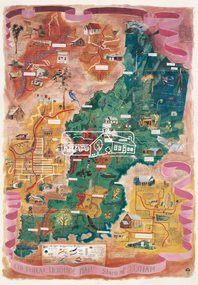
Map (item), Megan Evans, Cultural Heritage Map, Shire of Eltham, 1993
... Copy of artist's map of the Shire of Eltham with numerous historical and cultural places of interest illustrated and notated including evidence of original Wurundjeri occupation and local flora and fauna. The original watercolour is held in the Nillumbik Shire Council Civic...Eltham District Historical Society Inc 728 Main Rd Eltham melbourne Copy of artist's map of the Shire of Eltham with numerous historical and cultural places of interest illustrated and notated including evidence of original Wurundjeri occupation and local flora and fauna. The original watercolour is held in the Nillumbik Shire Council Civic ...Copy of artist's map of the Shire of Eltham with numerous historical and cultural places of interest illustrated and notated including evidence of original Wurundjeri occupation and local flora and fauna. The original watercolour is held in the Nillumbik Shire Council Civic Collection. "Evans remembers being surprised they had asked an artist to create this map rather than a designer. Originally made as a watercolour, the map was later made into posters and adorned many homes around the area. The map creatively interprets the town and provides a wayfinding to both cultural and historical points in the area." Nillumbik Arts News December 2023. artist, buildings, cultural heritage map, fauna, flora, map, megan evans, shire of eltham, wurundjeri -
 Eltham District Historical Society Inc
Document - Property Binder, Eltham Lower Park, Main Road, Eltham
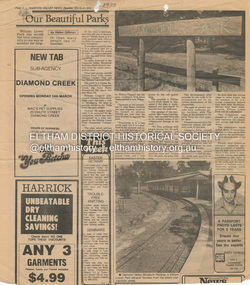
... map. Photographs of Miniature Railway at former location at Chelsworth Park Ivanhoe. Newspaper article: New BBQ at Eltham Park, The Advertiser, 9 July 1996, about a joint project between Nillumbik Council and Eltham Rotary (On same page an article about the showcasing of indigineous plants around Nillumbik Shire offices at Civic Drive and on p4 an article about redevelopment works at Elis Cottage)....map. Photographs of Miniature Railway at former location at Chelsworth Park Ivanhoe. Newspaper article: New BBQ at Eltham Park, The Advertiser, 9 July 1996, about a joint project between Nillumbik Council and Eltham Rotary (On same page an article about the showcasing of indigineous plants around Nillumbik Shire offices at Civic Drive and on p4 an article about redevelopment works at Elis Cottage). ...Newspaper article: Our Beautiful Parks, Diamond Valley News, 8 March 1983, describing Eltham Lower Park and Diamond Valley Miniature Railway. Newspaper article: Diamond Valley News, 8 March 1983, Election of the ALP, Peter Stables member for Diamond Valley. Flier for Diamond Valley Miniature Railway with photograph and map. Photographs of Miniature Railway at former location at Chelsworth Park Ivanhoe. Newspaper article: New BBQ at Eltham Park, The Advertiser, 9 July 1996, about a joint project between Nillumbik Council and Eltham Rotary (On same page an article about the showcasing of indigineous plants around Nillumbik Shire offices at Civic Drive and on p4 an article about redevelopment works at Elis Cottage).main road, parks, miniature railway, chelsworth park ivanhoe, bbq facilities, civic drive, eltham lower park, eltham rotary, landscape, nillumbik shire council, ellis cottage, eltham (vic), chelsworth park, ivanhoe, diamond valley railway -
 Eltham District Historical Society Inc
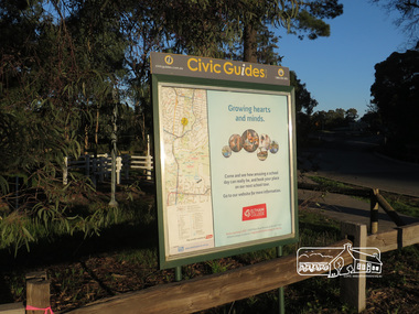
Photograph, Liz Pidgeon, Heritage Excursion; Eltham Lower Park, 1 July 2017
... Civic Guide sign near the entrance of Eltham Lower Park with a map of the local area and an advertisement for Eltham College Newsletter No., 234, June 2017 Heritage Excursion - Saturday 1st July - Eltham Lower Park - Walk and Talk Eltham Lower Park has played an important part in the history of our area since the early days of European settlement when it was used by local residents as an informal racecourse. ...Eltham District Historical Society Inc 728 Main Rd Eltham melbourne Civic Guide sign near the entrance of Eltham Lower Park with a map of the local area and an advertisement for Eltham College Newsletter No., 234, June 2017 Heritage Excursion - Saturday 1st July - Eltham Lower Park - Walk and Talk Eltham Lower Park has played an important part in the history of our area since the early days of European settlement when it was used by local residents as an informal racecourse. ...Civic Guide sign near the entrance of Eltham Lower Park with a map of the local area and an advertisement for Eltham College Newsletter No., 234, June 2017 Heritage Excursion - Saturday 1st July - Eltham Lower Park - Walk and Talk Eltham Lower Park has played an important part in the history of our area since the early days of European settlement when it was used by local residents as an informal racecourse. Prior to that its location at the junction of the Diamond Creek and the Yarra River made it an important meeting place for the Wurundjeri people. The park combines formal elements and sporting facilities with remnant bushland that is of environmental significance. It is home to sporting and horse riding clubs, popular play spaces and the Diamond Valley Miniature Railway, which attracts large numbers of visitors. The park will be the venue for our July excursion which will comprise a walk of about 3.5 km around the park and adjacent areas. Along the way we will discuss the history and natural history of the area. The path along the creek and the river provides a pleasant and scenic walk. This walk on Saturday 1st July is about 3.5 km in length and will take 2 to 2.5 hours. It will start at 2pm at the Main Road car park at the front of the park. (Melway ref 21 H 10). This sign was removed in about 2021 when works began on the building of an intersection to replace the roundabout at Fitzsimons Lane & Main Road. By May 2023 plantings in green spaces near Eltham Lower Park took place before the official opening of the new Eltham Gateway.Born Digitalheritage excursion, activities, eltham district historical society, eltham lower park, civic guide, eltham college, sign -
 Eltham District Historical Society Inc
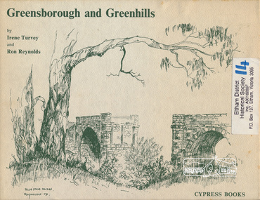
Book, Irene Turvey et al, Greensborough and Greenhills / words by Irene Turvey ; Drawings by Ron Reynolds, 1973
... Helena, Civic Centre, Briar Hill Timber Mill, 24 River Street, Kelly's Garden Supplies, 158 Main Street, Old Swimming pool, 105 Main Street. greenhills greensborough ISBN 0909807108 Signed by author and illustrator Two copies Hardback; 62 p. : ill., map ; 19 x 25 cm. ...Pen and ink sketches accompanied by appropriate text in double page spreads. Contents cover : Blue stone bridge, Introduction, House cnr Church and Hailes Street, House - 25 Hailes Street, Yandell Reserve, Greensborough Hotel, Lobb's Kiosk, House - 49 Grimshaw Street, View of Greensborough (from Delphin Crescent), Railway Station, Old Barn (near Greensborough Railway Station), Partington's Flat and River Valley, Rand Street Bridge, Lower Main Street, Greenbriar Nursery, Hitching rail, Ashmead - Dr Cordner's Home, Greensborough Primary School, House - cnr St Helena and Diamond Creek Raods, Sondermeyer's Hill, Methodist Church, Football Pavilion, Cemetery, St Katherine's Church, St. Helena, Civic Centre, Briar Hill Timber Mill, 24 River Street, Kelly's Garden Supplies, 158 Main Street, Old Swimming pool, 105 Main Street.Hardback; 62 p. : ill., map ; 19 x 25 cm.ISBN 0909807108 Signed by author and illustrator Two copiesgreenhills, greensborough -
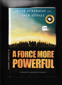 Monbulk RSL Sub Branch
Book, St Martins Press et al, A force more powerful : a century of nonviolent conflict, 2000
... It reveals the inside stories of how ordinary people took extraordinary action to end oppression - including the Danes' valiant resistance to the Nazis, Solidarity's defeat of Polish communism, and civic action in Chile to remove a military dictator - and how nonviolent power continues to change the world today, from Burma to the Balkans. Index, notes, ill, maps ...A Force More Powerful depicts how nonviolent sanctions - such as noncooperation, strikes, boycotts, and civil disobedience - can separate brutal regimes from their means of control. It reveals the inside stories of how ordinary people took extraordinary action to end oppression - including the Danes' valiant resistance to the Nazis, Solidarity's defeat of Polish communism, and civic action in Chile to remove a military dictator - and how nonviolent power continues to change the world today, from Burma to the Balkans.Index, notes, ill, maps, p.544.non-fictionA Force More Powerful depicts how nonviolent sanctions - such as noncooperation, strikes, boycotts, and civil disobedience - can separate brutal regimes from their means of control. It reveals the inside stories of how ordinary people took extraordinary action to end oppression - including the Danes' valiant resistance to the Nazis, Solidarity's defeat of Polish communism, and civic action in Chile to remove a military dictator - and how nonviolent power continues to change the world today, from Burma to the Balkans.non violence, social conflict -
Port Melbourne Historical & Preservation Society
Map - MMBW, 1897
... Large scale showing hotels, civic and industrial buildings, Graham Street to Bay, Nott and Dow Streets. Map MMBW ...Melbourne and Metropolitan Board of Works 1895, Plan No. 324, 328, 329 Segments shown: (as plan No's.) Large scale showing hotels, civic and industrial buildings, Graham Street to Bay, Nott and Dow Streets.engineering - board of works, business and traders - hotels, built environment, piers and wharves - town pier, transport - tramways -
Port Melbourne Historical & Preservation Society
Plan - Water cart used in road construction, Borough of Sandridge, 21 Nov 1870
... Port Melbourne Historical & Preservation Society Port Melbourne Town Hall 333 Bay Street Port Melbourne melbourne From a group of maps and plans not required by the Port Melbourne Council Engineering Department in May 1994 and offered at that time to the Port Melbourne Historical Society. built environment - civic engineering engineering department - borough of sandridge Plan of water cart used in road construction including 4 diagrams and scales: signed by Borough Surveyor, Nov 21 1870. ...From a group of maps and plans not required by the Port Melbourne Council Engineering Department in May 1994 and offered at that time to the Port Melbourne Historical Society.Plan of water cart used in road construction including 4 diagrams and scales: signed by Borough Surveyor, Nov 21 1870.built environment - civic, engineering, engineering department - borough of sandridge -
 Port Melbourne Historical & Preservation Society
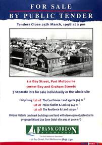
Flyer - Port Melbourne Courthouse, Frank Gordon and Co, For Sale by Public tender, 1998
... Port Melbourne Historical & Preservation Society Port Melbourne Town Hall 333 Bay Street Port Melbourne melbourne Built Environment - Civic Bay Street Law Police Police Station Court House Lockup Cell Block Frank Gordon & Co A for Sale notice of 4 pages. Dark blue background. Header and photo of Port Melbourne Courthouse, Police Station and residence at 111 Bay Street. Inside pages have a map ...A for Sale notice of 4 pages. Dark blue background. Header and photo of Port Melbourne Courthouse, Police Station and residence at 111 Bay Street. Inside pages have a map and pictures of the buidings, identified by Lots.built environment - civic, bay street, law, police, police station, court house, lockup, cell block, frank gordon & co -
Port Melbourne Historical & Preservation Society
Manual, Collins Street Directory 1961, 1961
... Port Melbourne Historical & Preservation Society Port Melbourne Town Hall 333 Bay Street Port Melbourne melbourne This compact Collins Street Directory has 178 detailed maps and shows postal district numbers used at that time. Built Environment - Civic Collins Book Depot {ty Ltd Small directory of Melbourne streets in 1961 including a separate map of all areas covered by the directory & their map reference numbers. ...This compact Collins Street Directory has 178 detailed maps and shows postal district numbers used at that time.Small directory of Melbourne streets in 1961 including a separate map of all areas covered by the directory & their map reference numbers.built environment - civic, collins book depot {ty ltd -
Port Melbourne Historical & Preservation Society
Document - Research report, Heritage study of "Clareville" and McCormack Gallery", Robyn Clinch, Heritage Study of "Clareville"and the "McCormack Gallery" Port Melbourne, Jan 2008
... Port Melbourne Historical & Preservation Society Port Melbourne Town Hall 333 Bay Street Port Melbourne melbourne Submitted as part of the requirements for the subject "Heritage Planning"at RMIT University for the degree of Master of Social Science Environment. w Built Environment - Civic Built Environment - Domestic Port Melbourne Temperance Hall Town Planning Heritage Robyn CLINCH Clareville McCormack Gallery Frederick WILLIAMS William Hutcheson GRESHAM Jane DIXON Maxwell INGLES John GALL James John BARTLETT Edward W M SUFFOLK Ann McGRATH SUFFOLK Edward Dicker MATHEWS Elizabeth Payne Beck MATHEWS Thomas McCORMACK Mathew McCORMACK Catherine Larkin McCORMACK Maryann Farnan McCORMACK Alexander James DOIG Alice Bevan DOIG Stephen SPADIER Harriet Jane Blackell SPADIER Cricketers Arms Hotel Heritage Study of "Clareville"and the "McCormack Gallery" Port Melbourne - A4 bound with red plastic comb. 62 pages with red back. Contains comparative studies from Port and South Melbourne, photos and maps ...Submitted as part of the requirements for the subject "Heritage Planning"at RMIT University for the degree of Master of Social Science Environment.wHeritage Study of "Clareville"and the "McCormack Gallery" Port Melbourne - A4 bound with red plastic comb. 62 pages with red back. Contains comparative studies from Port and South Melbourne, photos and mapsbuilt environment - civic, built environment - domestic, port melbourne temperance hall, town planning, heritage, robyn clinch, clareville, mccormack gallery, frederick williams, william hutcheson gresham, jane dixon, maxwell ingles, john gall, james john bartlett, edward w m suffolk, ann mcgrath suffolk, edward dicker mathews, elizabeth payne beck mathews, thomas mccormack, mathew mccormack, catherine larkin mccormack, maryann farnan mccormack, alexander james doig, alice bevan doig, stephen spadier, harriet jane blackell spadier, cricketers arms hotel -
 Flagstaff Hill Maritime Museum and Village
Document - Map, Department of Lands & Survey, Victoria / Panmure, 1942
... civic affairs. They were both involved in the creation of Flagstaff Hill Maritime Village, including the layout of the gardens. After his death on 28th March 1970 his family requested his practitioner’s plate, medical instruments and some personal belongings be displayed in the Port Medical Office surgery at Flagstaff Hill Maritime Village, and be called the “W. R. Angus Collection”. This Emergency Edition of the Map ...This Emergency Edition of the map of Panmure, Victoria, is part of the W.R. Angus Collection. It was printed in 1942 during World War II. It is one of two maps donated to Flagstaff Hill Maritime Village by the family of Doctor William Roy Angus, who served as Surgeon Captain in the Australian Defence Department. The map was compiled for the Dept. of Army by the Dept. of Lands and Survey in Melbourne, prepared by the Australian Section of the Imperial General Staff, which was a British Government body created in 1907 to co-ordinate the defence of Britain and its Empire. It was printed by A.H.Q. Cartographic Company, Survey Corps, which was formed in 1941. The Corp changed its name to L.H.Q. Cartographic Company of Bendigo. In 1947 the name reverted back to the A.H.Q. Cartographic Company until 1955 when it became the A.H.Q. Survey Regiment. The W.R. Angus Collection includes historical medical equipment, surgical instruments and material once belonging to Dr Edward Ryan and Dr Thomas Francis Ryan, (both of Nhill, Victoria) as well as Dr Angus’ own belongings. The Collection’s history spans the medical practices of the two Doctors Ryan, from 1885-1926 plus that of Dr Angus who began practice in 1924. Dr. Angus served with the Australian Department of Defence as a Surgeon Captain during the Second World Was from 1942 to 1945. He served in Ballarat, Victoria, and in Bonegilla, N.S.W. until he suffering from a heart attack just before the war ended. ABOUT THE “W.R.ANGUS COLLECTION” - Doctor William Roy Angus M.B., B.S., Adel., 1923, F.R.C.S. Edin.,1928, was generally known as Dr Roy Angus. His working life included a position as a doctor with the Flying Doctor Service in Australia’s rural and remote areas. After many varied experiences Dr Angus and his family moved to Warrnambool in 1939 where he purchased “Birchwood,” the 1852 home and medical practice of Dr John Hunter Henderson. He was appointed on a part-time basis as Port Medical Officer in Warrnambool and held this position until the 1940’s when the government no longer required the service of a Port Medical Officer. Dr Angus was a surgeon at the Warrnambool Base Hospital 1939-1942. After further studies he commenced practice as an ophthalmologist in Warrnambool, pioneering in artificial eye improvements. He was Honorary Consultant Ophthalmologist to Warrnambool Base Hospital for 31 years and made monthly visits to Portland to perform eye surgery. Dr Angus and his wife Gladys were very involved in Warrnambool’s community with a strong interest in civic affairs. They were both involved in the creation of Flagstaff Hill Maritime Village, including the layout of the gardens. After his death on 28th March 1970 his family requested his practitioner’s plate, medical instruments and some personal belongings be displayed in the Port Medical Office surgery at Flagstaff Hill Maritime Village, and be called the “W. R. Angus Collection”. This Emergency Edition of the Map of Panmure is significant as an example of the documents prepared for the defence of Australia in World War 2. The Map is also significant for its connection between the Australian Army and the involvement of Dr WR Angus as a Surgeon in the Medical Services during World War II. The W.R. Angus Collection is significant for still being located at the site it is connected with, Doctor Angus being the last Port Medical Officer in Warrnambool. The collection of medical instruments and other equipment is culturally significant, being an historical example of medicine, administration, household equipment and clothing from late 19th to mid-20th century. Dr Angus assisted Dr Tom Ryan, a pioneer in the use of X-rays and in ocular surgery. The collection includes Dr Angus’s Army objects and is significant as an example of items issued to Doctors and Surgeons in the Medical Services of the Australian Army in World War IIMilitary map of Panmure, Victoria, Australia; part of the W.R. Angus Collection. Rectangular coloured map on cream paper for the Australian Army. Details include sea, waterways and land, contour lines, grid lines, names of districts, towns and roads, bridges, swamps, rail lines, cuttings, tracks, buildings (including blacksmiths), pumps, lighthouses, telegraph, telephones and electric transmission lines, and fire stations. The map has margin notes that include distances in miles to nearby towns. The map was compiled for the Dept. of Army by the Dept. of Lands and Survey in Melbourne, prepared by the Australian Section, Imperial General Staff and printed by A.H.Q. Cartographic Company, Melbourne in 1942. Crown Copyright Reserved. Inscriptions in red print state that it is and Emergency Edition and an Official document. An oval purple stamp includes the price.Printed in black; 'Victoria / Panmure", "No. 930 / Zone 6" Printed in red; “EMERGENCY EDITION”, “THIS MAP IS AN OFFICIAL DOCUMENT. IF FOUND, IT MUST BE HANDED / IN TO THE NEAREST MILITARY HEADQUARTERS OR POLICE STATION” Stamped: within concentric ovals (“- - - FOR SALE / PRICE 2/- / - - - - - OF THE ARMY”)flagstaff hill, warrnambool, flagstaff hill maritime museum, maritime museum, shipwreck coast, flagstaff hill maritime village, great ocean road, dr w r angus, dr ryan, warrnambool base hospital, flying doctor, surgeon captain, australian department of defence, royal australian army, world war 2, map panmure 1942, roy angus, port medical officer, nhill base hospital, military map, emergency map, military service australian army, department of army, department of lands and survey, a.h.q. cartographic company melbourne, panmure 1942, australian section, imperial general staff -
 Flagstaff Hill Maritime Museum and Village
Document - Map, Department of Lands & Survey, Victoria / Port Campbell, 1942
... civic affairs. They were both involved in the creation of Flagstaff Hill Maritime Village, including the layout of the gardens. After his death on 28th March 1970 his family requested his practitioner’s plate, medical instruments and some personal belongings be displayed in the Port Medical Office surgery at Flagstaff Hill Maritime Village, and be called the “W. R. Angus Collection”. This Emergency Edition of the Map ...This Emergency Edition of the map of Port Campbell, Victoria, is part of the W.R. Angus Collection. It was printed in 1942 during World War II. It is one of two maps donated to Flagstaff Hill Maritime Village by the family of Doctor William Roy Angus, who served as Surgeon Captain in the Australian Defence Department. The map was compiled for the Dept. of Army by the Dept. of Lands and Survey in Melbourne, prepared by the Australian Section of the Imperial General Staff, which was a British Government body created in 1907 to co-ordinate the defence of Britain and its Empire. It was printed by A.H.Q. Cartographic Company, Survey Corps, which was formed in 1941. The Corp changed its name to L.H.Q. Cartographic Company of Bendigo. In 1947 the name reverted back to the A.H.Q. Cartographic Company until 1955 when it became the A.H.Q. Survey Regiment. The W.R. Angus Collection includes historical medical equipment, surgical instruments and material once belonging to Dr Edward Ryan and Dr Thomas Francis Ryan, (both of Nhill, Victoria) as well as Dr Angus’ own belongings. The Collection’s history spans the medical practices of the two Doctors Ryan, from 1885-1926 plus that of Dr Angus who began practice in 1924. Dr Angus served with the Australian Department of Defence as a Surgeon Captain during the Second World Was from 1942 to 1945. He served in Ballarat, Victoria, and in Bonegilla, N.S.W. until he suffering from a heart attack just before the war ended. ABOUT THE “W.R.ANGUS COLLECTION” - Doctor William Roy Angus M.B., B.S., Adel., 1923, F.R.C.S. Edin.,1928, was generally known as Dr Roy Angus. His working life included a position as a doctor with the Flying Doctor Service in Australia’s rural and remote areas. After many varied experiences Dr Angus and his family moved to Warrnambool in 1939 where he purchased “Birchwood,” the 1852 home and medical practice of Dr John Hunter Henderson. He was appointed on a part-time basis as Port Medical Officer in Warrnambool and held this position until the 1940’s when the government no longer required the service of a Port Medical Officer. Dr Angus was a surgeon at the Warrnambool Base Hospital 1939-1942. After further studies he commenced practice as an ophthalmologist in Warrnambool, pioneering in artificial eye improvements. He was Honorary Consultant Ophthalmologist to Warrnambool Base Hospital for 31 years and made monthly visits to Portland to perform eye surgery. Dr Angus and his wife Gladys were very involved in Warrnambool’s community with a strong interest in civic affairs. They were both involved in the creation of Flagstaff Hill Maritime Village, including the layout of the gardens. After his death on 28th March 1970 his family requested his practitioner’s plate, medical instruments and some personal belongings be displayed in the Port Medical Office surgery at Flagstaff Hill Maritime Village, and be called the “W. R. Angus Collection”. This Emergency Edition of the Map of Port Campbell is significant as an example of the documents prepared for the defence of Australia in World War 2. The Map is also significant for its connection between the Australian Army and the involvement of Dr WR Angus as a Surgeon in the Medical Services during World War II. The W.R. Angus Collection is significant for still being located at the site it is connected with, Doctor Angus being the last Port Medical Officer in Warrnambool. The collection of medical instruments and other equipment is culturally significant, being an historical example of medicine, administration, household equipment and clothing from late 19th to mid-20th century. Dr Angus assisted Dr Tom Ryan, a pioneer in the use of X-rays and in ocular surgery. The collection includes Dr Angus’s Army objects and is significant as an example of items issued to Doctors and Surgeons in the Medical Services of the Australian Army in World War IIMilitary map of Port Campbell, Victoria, Australia; part of the W.R. Angus Collection. Rectangular coloured map on cream paper for the Australian Army. Details include sea, waterways and land, contour lines, grid lines, names of districts, towns and roads, bridges, swamps, rail lines, cuttings, tracks, buildings (including blacksmiths), pumps, lighthouses, telegraph, telephones and electric transmission lines, and fire stations. The map has margin notes that include distances in miles to nearby towns. The map was compiled for the Dept. of Army by the Dept. of Lands and Survey in Melbourne, prepared by the Australian Section, Imperial General Staff and printed by A.H.Q. Cartographic Company, Melbourne in 1942. Crown Copyright Reserved. Inscriptions in red print state that it is and Emergency Edition and an Official document. An oval purple stamp includes the price.Printed in black; 'Victoria / Port Campbell", "No. 932 / Zone 6" Printed in red; “EMERGENCY EDITION”, “THIS MAP IS AN OFFICIAL DOCUMENT. IF FOUND, IT MUST BE HANDED / IN TO THE NEAREST MILITARY HEADQUARTERS OR POLICE STATION” Stamped: within concentric ovals (“- - - FOR SALE / PRICE 2/- / - - - - - OF THE ARMY”)flagstaff hill, warrnambool, flagstaff hill maritime museum, maritime museum, shipwreck coast, flagstaff hill maritime village, great ocean road, dr w r angus, dr ryan, warrnambool base hospital, nhill base hospital, flying doctor, surgeon captain, map port campbell 1942, roy angus, port medical officer, military map, emergency map, australian department of defence, royal australian army, military service australian army, department of army, department of lands and survey, world war 2, a.h.q. cartographic company melbourne, australian section, imperial general staff, port campbell 1942 -
 Ringwood and District Historical Society
Document, City of Ringwood, Demographic profile of the City of Ringwood August 1989
... Civic Centre - New Telephone Numbers; 5. City of Ringwood - Boundary Map; 6. ...Civic Centre - New Telephone Numbers; 5. City of Ringwood - Boundary Map; 6. ...During refurbishment of office in Civic Centre sent to VRDHS by Miranda de Giorgio, Community Liaison Officer 8-Dec-1993.Collection of documents about the City of Ringwood - civic centre.; 1. Demographic profile of the City of Ringwood August 1989.; 2. City of Ringwood - An Information Guide for Students- Nov 1991.; 3. Councillors names and addresses 5-Aug-1991; 4. Civic Centre - New Telephone Numbers; 5. City of Ringwood - Boundary Map; 6. City of Ringwood - 3 folders (2 coloured) 1960 +Additional Keywords: de Giorgio, Miranda -
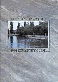 Ringwood and District Historical Society
Book, City of Ringwood, City of Ringwood 1992 Community Guide, 1992
... CONTENTS: (page no.) 1991/92 COUNCIL REPRESENTATIVES 4 1992 CALENDAR 51 AQUATIC CENTRE 8 AQUATIC CENTRE VOUCHERS 49 CHIEF EXECUTIVE'S REPORT 6 CIVIC CENTRE TELEPHONE INDEX — DIRECT DIALLING 53 COMMUNITY DIRECTORY 35-47 COMMUNITY SERVICES 17-19 COUNCIL & COMMITTEE CYCLES 4 COUNCIL FINANCES & 1991/92 RATES 16 COUNCILLORS 3 FUNCTIONAL RESPONSIBILITIES 15 HISTORY OF RINGWOOD 5 HOUSING & RESIDENTIAL DEVELOPMENT 29-30 INFRASTRUCTURE 34 LOCAL, STATE & FEDERAL GOVERNMENT ELECTIONS 32 MANAGEMENT TEAM 14 MAYORAL MESSAGE – Cr. Max Williams 1 NEIGHBOURHOOD MAP...Ringwood and District Historical Society 125A Warrandyte Road Ringwood North melbourne rinx CONTENTS: (page no.) 1991/92 COUNCIL REPRESENTATIVES 4 1992 CALENDAR 51 AQUATIC CENTRE 8 AQUATIC CENTRE VOUCHERS 49 CHIEF EXECUTIVE'S REPORT 6 CIVIC CENTRE TELEPHONE INDEX — DIRECT DIALLING 53 COMMUNITY DIRECTORY 35-47 COMMUNITY SERVICES 17-19 COUNCIL & COMMITTEE CYCLES 4 COUNCIL FINANCES & 1991/92 RATES 16 COUNCILLORS 3 FUNCTIONAL RESPONSIBILITIES 15 HISTORY OF RINGWOOD 5 HOUSING & RESIDENTIAL DEVELOPMENT 29-30 INFRASTRUCTURE 34 LOCAL, STATE & FEDERAL GOVERNMENT ELECTIONS 32 MANAGEMENT TEAM 14 MAYORAL MESSAGE – Cr. Max Williams 1 NEIGHBOURHOOD MAP ...Community information book issued by City of Ringwood for 1992 - covering the facilities and activities of the Ringwood Council and other local organisations and associations. Includes two Aquatic Centre entry vouchers valid until June 30th, 1992.CONTENTS: (page no.) 1991/92 COUNCIL REPRESENTATIVES 4 1992 CALENDAR 51 AQUATIC CENTRE 8 AQUATIC CENTRE VOUCHERS 49 CHIEF EXECUTIVE'S REPORT 6 CIVIC CENTRE TELEPHONE INDEX — DIRECT DIALLING 53 COMMUNITY DIRECTORY 35-47 COMMUNITY SERVICES 17-19 COUNCIL & COMMITTEE CYCLES 4 COUNCIL FINANCES & 1991/92 RATES 16 COUNCILLORS 3 FUNCTIONAL RESPONSIBILITIES 15 HISTORY OF RINGWOOD 5 HOUSING & RESIDENTIAL DEVELOPMENT 29-30 INFRASTRUCTURE 34 LOCAL, STATE & FEDERAL GOVERNMENT ELECTIONS 32 MANAGEMENT TEAM 14 MAYORAL MESSAGE – Cr. Max Williams 1 NEIGHBOURHOOD MAP 26-27 NOTES 52 PAPER & CARDBOARD COLLECTION SERVICE 22 PARKS & RESERVES — PUBLIC FACILITIES 31 PROTECTING OUR COMMUNITY 23-24 PROTECTING THE ENVIRONMENT 20-21 RINGWOOD FESTIVAL & HIGHLAND CARNIVAL 13 RINGWOOD GOLF COURSE 7 STRATEGIC BIKE PLAN 11 STREET INDEX A-L 25 STREET INDEX L-Z 28 THE LIBRARY 12 THE RINGWOOD CONVENTION & PERFORMING ARTS CENTRE 10 TRAFFIC MANAGEMENT 33 YOUR PERSONAL DIRECTORY 50 rinx -
 Greensborough Historical Society
Booklet, Heidelberg 1937 - excerpts, 1937_04
... A snapshot of the Heidelberg area in 1937, includes photos of local homes and civic amenities heidelberg municipal offices heidelberg town hall the centre ivanhoe This flyer is an extract of images from the City of Heidelberg Civic Centre Official Opening Booklet "Heidelberg 1937" [footnote on each page] 12 pages, photocopied and folded to A5 size. Black and white photos, maps ...Copy of parts of 1937 booklet to commemorate the official opening of the City of Heidelberg Civic Centre - Town Hall and Municipal Offices.A snapshot of the Heidelberg area in 1937, includes photos of local homes and civic amenities12 pages, photocopied and folded to A5 size. Black and white photos, maps.This flyer is an extract of images from the City of Heidelberg Civic Centre Official Opening Booklet "Heidelberg 1937" [footnote on each page]heidelberg municipal offices, heidelberg town hall, the centre ivanhoe -
 Greensborough Historical Society
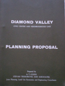
Document - Planning Document, Diamond Valley Civic Centre and Neighbourhood Unit: Planning Proposal, 1960s
... Includes statistics relating to population increase. partington family mitchell family whittingham family albion reid diamond valley civic centre shire of diamond valley Dark brown plastic folder. 23 foolscap-size pages. Maps ...This document proposes the change of land use from farming and quarrying to residential. This also includes the proposal for a Civic Centre in the (then) Shire of Diamond Valley. The plans listed in the 'Schedule of Plans' on last page are missing.Includes proposal for the Aqueduct to be converted to an underground system. Includes statistics relating to population increase. Dark brown plastic folder. 23 foolscap-size pages. Maps, Application for Permits to subdivide land in the Greensborough area.partington family, mitchell family, whittingham family, albion reid, diamond valley civic centre, shire of diamond valley -
 Greensborough Historical Society
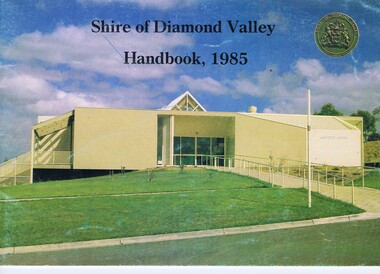
Booklet, Shire of Diamond Valley Handbook 1985, 1985_
... Civic Centre Greensborough, opened 1985. Annual guide to services in Shire of Diamond Valley shire of diamond valley greensborough handbooks 32 pages, col illus., maps. 2 copies. ...Guide to services provided by Shire of Diamond Valley. The Shire of Diamond Valley was a Local Government Area located about 20 kilometres northeast of Melbourne. The shire covered an area of 74.38 square kilometres and existed from 1964 until 1994. Cover illustration of Library/Arts facility at Civic Centre Greensborough, opened 1985.Annual guide to services in Shire of Diamond Valley32 pages, col illus., maps. 2 copies.shire of diamond valley, greensborough, handbooks -
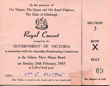 Broadmeadows Historical Society & Museum
Ephemera - Ticket, Government of Victoria, Royal Concert Ticket, 1963, 1962/63
... civic and national significance. Hosted at Melbourne’s Sidney Myer Music Bowl, the event required large-scale crowd management, evidenced by the printed access map on the ticket. ...civic and national significance. Hosted at Melbourne’s Sidney Myer Music Bowl, the event required large-scale crowd management, evidenced by the printed access map on the ticket. ...The ticket documents a Royal Concert held during the 1963 visit of the British monarch and consort to Australia, organised by the Government of Victoria with the Australian Broadcasting Commission, reflecting its civic and national significance. Hosted at Melbourne’s Sidney Myer Music Bowl, the event required large-scale crowd management, evidenced by the printed access map on the ticket. The named bearer and fixed, non-transferable seating indicate controlled attendance and heightened security appropriate to a royal event.This item has local historic significance for Broadmeadows and Campbellfield, providing primary evidence of major industrial development and civic engagement in Victoria during the 1960s.This item is of historic and social significance as tangible evidence of civic life, monarchy-related public events, and state-organised cultural programming in Victoria during the early 1960s. It documents public engagement with royal visits and the ceremonial relationship between Australia and the British Crown in the mid 20th century.Single sheet of pale pink paper, printed in black ink, folded vertically. The recto contains formal event text and seat information. The verso contains a printed location map and directional diagram.Recto (front): “In the presence/of Her Majesty The Queen and His Royal Highness/The Duke of Edinburgh”/“Royal Concert”/“arranged by/the Government of Victoria”/“in association with the Australian Broadcasting Commission”/“at the Sidney Myer Music Bowl”/“on Sunday, 24th February, 1963”/“at 2.30 o’clock p.m.”/“Admit… Mr C. Mutton” / “This Ticket is issued to the bearer and is not transferable”/“SECTION 3”/“ROW X”/“SEAT 69” Verso (back): “From Linlithgow Ave”/“King George V Memorial”/“Swan St Bridge”/“Alexandra Ave”/“To Sections 2 & 3”/ Hand-applied label: “WI-4242” royal visit, royal concert, 1963, sidney myer music bowl, victoria government, australian broadcasting commission, queen elizabeth ii, duke of edinburgh, melbourne, souvenir, admission ticket, civic ceremony, crowd management, seated allocation, cultural event -
Lakes Entrance Historical Society
Map - Laminated poster depicting WW1 Europe
... CIVIC MEMENTOES Memorials Laminated poster depicting WW1 Europe on front, and details of war memorials on reverse Map Laminated poster depicting WW1 Europe ...Laminated poster depicting WW1 Europe on front, and details of war memorials on reversecivic mementoes, memorials -
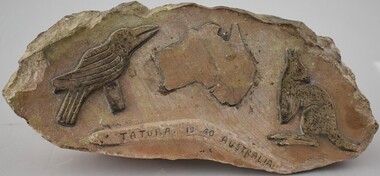 Tatura Irrigation & Wartime Camps Museum
Plaque, 1940s
... Tatura Irrigation & Wartime Camps Museum 49 Hogan Street Tatura the-murray Carved by German POW at Camp 13 civic mementos - plaques internee stone carvings Tatura 1940 Australia Bas relief stone carving. A map ...Carved by German POW at Camp 13Bas relief stone carving. A map of Australia, flanked by a kangaroo, boomerang and a kookaburra and "Tatura 1940 Australia" on the boomerangTatura 1940 Australiacivic mementos - plaques, internee stone carvings -
Tatura Irrigation & Wartime Camps Museum
Banner
... Tatura Irrigation & Wartime Camps Museum 49 Hogan Street Tatura the-murray Used by Tatura Apex Club banner tatura apex tatura service clubs civic memento banners White satin banner, red border, red map of Australia with Apex emblem, Banner ...Used by Tatura Apex ClubWhite satin banner, red border, red map of Australia with Apex emblem,banner tatura, apex, tatura, service clubs, civic, memento, banners