Showing 99 items matching "closed victorian railways"
-
 Wodonga & District Historical Society Inc
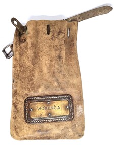
Functional object - Leather pouch and stamps - Cudgewa Railway Line
... ...Victorian Railways...Closed...These stamps were used by Joh Murray who for many years worked with Victorian Railways based at Wodonga. Cudgewa rail line Victorian Railways Closed Victorian Railways Railway stamps On pouch WODONGA On stamps: BONEGILLA 1470/ EBDEN 1471/ BANDOLIER 1473 A leather pouch with belt and lock. ...Cudgewa Line -The Cudgewa railway line opened in stages between 1889 and 1921. The first section from Wodonga to Huon opened on 10 September 1889. It was extended to Bolga on 18 July 1890, Tallangatta on 24 July 1891 and then to Shelley on 13 June 1916. Shelley was the highest station in Victoria. It extended further on to Beetomba on 10 April 1919 and finally reached Cudgewa on 5 May 1921. The line had 1 in 30 grades and trestle bridges that have been heritage listed. In 1919, the line was used to carry materials for the construction of Hume Weir, and three years later a spur line connecting Ebden to the weir was opened. In the 1960s, Cudgewa became the railhead of materials for the Snowy Mountains Scheme. The last passenger service from Wodonga to Tallangatta ran on 30 September 1961. The turntable and passenger platform at Cudgewa were abolished in 1976. These stamps were used by Joh Murray who for many years worked with Victorian Railways based at Wodonga.A leather pouch with belt and lock. It bears a metal name tag inscribed with name of railway station. The pouch contains 3 station stamps, a date stamp and 2 carriage keys.On pouch WODONGA On stamps: BONEGILLA 1470/ EBDEN 1471/ BANDOLIER 1473cudgewa rail line, victorian railways, closed victorian railways, railway stamps -
 Wodonga & District Historical Society Inc
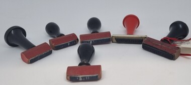
Functional object - Railway Station stamps Cudgewa Line
... ...Victorian Railways...Closed...Cudgewa rail line Victorian Railways Closed Victorian Railways On individual stamps: 1. ...Cudgewa Line -The Cudgewa railway line opened in stages between 1889 and 1921. The first section from Wodonga to Huon opened on 10 September 1889. It was extended to Bolga on 18 July 1890, Tallangatta on 24 July 1891 and then to Shelley on 13 June 1916. Shelley was the highest station in Victoria. It extended further on to Beetomba on 10 April 1919 and finally reached Cudgewa on 5 May 1921. The line had 1 in 30 grades and trestle bridges that have been heritage listed. In 1919, the line was used to carry materials for the construction of Hume Weir, and three years later a spur line connecting Ebden to the weir was opened. In the 1960s, Cudgewa became the railhead of materials for the Snowy Mountains Scheme. The last passenger service from Wodonga to Tallangatta ran on 30 September 1961. The turntable and passenger platform at Cudgewa were abolished in 1976.6 Rubber and wood stamps used in the stations along the Cudgewa Line. The stamps were primarily used to acknowledge receipt of small freight items carried on the Cudgewa LineOn individual stamps: 1. TALLANGATTA 1476 2. BULLIOH 1477 3. BEETOOMBA 1484 4. KOETONG 1480 5. SHELLEY 1482 6. CORRYONG 1487cudgewa rail line, victorian railways, closed victorian railways -
 Emerald Museum & Nobelius Heritage Park
Photograph - Photograph of Puffing Billy, 1950s
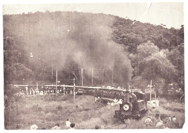
... closed by the Victorian Government following falling passenger numbers and a landslide near Menzies Creek. This photograph is believed to have been taken on one of three special days in December 1954 and January 1955 negotiated by the Herald and Weekly Times for its 'Young Sun' readers before the line was permanently closed. A public campaign to reopen the line ensued. This photo is taken of the train crossing the road at Upper Ferntree gully. At that time, there was no railway...closed by the Victorian Government following falling passenger numbers and a landslide near Menzies Creek. This photograph is believed to have been taken on one of three special days in December 1954 and January 1955 negotiated by the Herald and Weekly Times for its 'Young Sun' readers before the line was permanently closed. A public campaign to reopen the line ensued. This photo is taken of the train crossing the road at Upper Ferntree gully. At that time, there was no railway ...Puffing Billy was scheduled to be closed by the Victorian Government following falling passenger numbers and a landslide near Menzies Creek. This photograph is believed to have been taken on one of three special days in December 1954 and January 1955 negotiated by the Herald and Weekly Times for its 'Young Sun' readers before the line was permanently closed. A public campaign to reopen the line ensued. This photo is taken of the train crossing the road at Upper Ferntree gully. At that time, there was no railway bridge to separate the crossing from the road.Black and white photograph of Puffing Billy train crossing the road at Upper Ferntree Gully towards Belgrave c. December 1954 - the train is packed with passengers and with many well-wishers standing on the tracks.puffing billy, herald and weekly times, young sun, upper ferntree gully -
 Orbost & District Historical Society
railways envelope, C 1980's
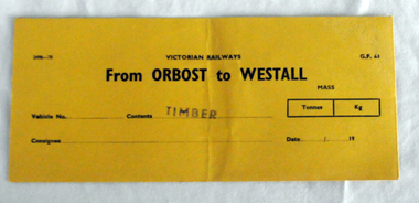
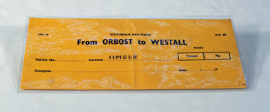
... railway line, and closed in 1987. The station was located on the west side of the Snowy River despite the town of Orbost being on the east side of the river, in order to save on the costs of a bridge over the river, which at the time had highly variable levels. This item is associated with the history of the Orbost-Bairnsdale railway line and therefore reflects the role that the rail line played in the social and economic history of Orbost. Orbost-Bairnsdale-railway Westall 2497-78 VICTORIAN ...This item was used by Victorian Railways 1970's/1980's. It was used at Orbost Railway Station for the consignment of timber from Orbost to Westall.. Westall was a major timber-receiving depot near Dandenong, Victoria. Westall railway station is located on the Pakenham and Cranbourne lines in Victoria, Australia. It serves the south-eastern Melbourne suburb of Clayton South, opening on 6 February 1951. Westall station was opened as a workers only platform on 16 October 1954. It was provided for the adjacent Martin & King railway coachbuilding factory. The station was opened to the public on 1 June 1959 when all trains on the line began stopping there. The Bairnsdale-Orbost railway was opened in 1916 to serve the agricultural and timber industry. Because of the decline in traffic and heavy operating costs, the line was finally closed in August, 1987. Orbost Railway Station was opened on Monday 10 April 1916 as the terminus of the Orbost railway line, and closed in 1987. The station was located on the west side of the Snowy River despite the town of Orbost being on the east side of the river, in order to save on the costs of a bridge over the river, which at the time had highly variable levels. This item is associated with the history of the Orbost-Bairnsdale railway line and therefore reflects the role that the rail line played in the social and economic history of Orbost.An unused brown/buff coloured goods/freight consignment envelope used by Victorian Railways, this one for timber from Orbost to Westall. It is DL size.2497-78 VICTORIAN RAILWAYS G.F 63 From ORBOST to WESTALL MASS Tonnes kg Vehicle No Contents TIMBER Consignee Date orbost-bairnsdale-railway westall -
 Orbost & District Historical Society
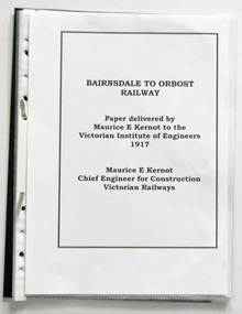
document in folder, Bairnsdale to Orbost Railway Paper Delivered by Maurice Kernot 1917, March 2016
... Railway 100 Years Exhibition held at Orbost in March, 2016. It is a copy of an original paper delivered by Maurice Kernot to the Victorian Institute of Engineers in 1917. Maurice Edwin Kernot was the vice president and managed the construction of the Bairnsdale-Orbost Railway in 1912. The Bairnsdale-Orbost railway was opened in 1916 to serve the agricultural and timber industry. Because of the decline in traffic and heavy operating costs, the line was finally closed...Railway 100 Years Exhibition held at Orbost in March, 2016. It is a copy of an original paper delivered by Maurice Kernot to the Victorian Institute of Engineers in 1917. Maurice Edwin Kernot was the vice president and managed the construction of the Bairnsdale-Orbost Railway in 1912. The Bairnsdale-Orbost railway was opened in 1916 to serve the agricultural and timber industry. Because of the decline in traffic and heavy operating costs, the line was finally closed ...This item was made for the Orbost Railway 100 Years Exhibition held at Orbost in March, 2016. It is a copy of an original paper delivered by Maurice Kernot to the Victorian Institute of Engineers in 1917. Maurice Edwin Kernot was the vice president and managed the construction of the Bairnsdale-Orbost Railway in 1912. The Bairnsdale-Orbost railway was opened in 1916 to serve the agricultural and timber industry. Because of the decline in traffic and heavy operating costs, the line was finally closed in August, 1987.This item is associated with the history of the Orbost-Bairnsdale railway line and therefore reflects the role that the rail line played in the social and economic history of Orbost.Seventeen pages of photocopied document in a black plastic folder. The pages are in separate sleeves. On the back is a price sticker $1 flat file Marbig Single - Red Orbost Authorid News.orbost-bairnsdale-railway east-gippsland-railway kernot-maurice railway -
 Orbost & District Historical Society
label / sign, 1970's -1980's
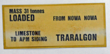
... Victorian Railways in 1980's. It was inserted onto the side of railway freight wagons. The Bairnsdale-Orbost railway was opened in 1916 to serve the agricultural and timber industry. Because of the decline in traffic and heavy operating costs, the line was finally closed...Victorian Railways in 1980's. It was inserted onto the side of railway freight wagons. The Bairnsdale-Orbost railway was opened in 1916 to serve the agricultural and timber industry. Because of the decline in traffic and heavy operating costs, the line was finally closed ...This item was used by Victorian Railways in 1980's. It was inserted onto the side of railway freight wagons. The Bairnsdale-Orbost railway was opened in 1916 to serve the agricultural and timber industry. Because of the decline in traffic and heavy operating costs, the line was finally closed in August, 1987. Orbost Railway Station was opened on Monday 10 April 1916 as the terminus of the Orbost railway line, and closed in 1987. The station was located on the west side of the Snowy River despite the town of Orbost being on the east side of the river, in order to save on the costs of a bridge over the river, which at the time had highly variable levels This item is associated with the history of the Orbost-Bairnsdale railway line and therefore reflects the role that the rail line played in the social and economic history of Orbost.A double -sided rectangular shaped label / sign, heavily laminated.Black print on light brown background. On one side : "MASS 31 tonnes LOADED; FROM NOWA NOWA; LIMESTONE TO APM SIDING; TRARALGON". On reverse : "EMPTY FROM TRARALGON; TO APM LIMESTONE SIDING ; NOWA NOWA".freight orbost-bairnsdale-railway -
 Orbost & District Historical Society
map, Railway Map of Victoria, 1.8.1965
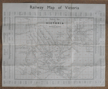
... railway was opened in 1916 to serve the agricultural and timber industry. Because of the decline in traffic and heavy operating costs, the line was finally closed in August, 1987. This item is associated with the history of the Orbost-Bairnsdale railway line and therefore reflects the role that the rail line played in the social and economic history of Orbost. map-railway Victorian-Railways A large rectangular shaped paper map of all railway stations in Victoria. ...The Bairnsdale-Orbost railway was opened in 1916 to serve the agricultural and timber industry. Because of the decline in traffic and heavy operating costs, the line was finally closed in August, 1987.This item is associated with the history of the Orbost-Bairnsdale railway line and therefore reflects the role that the rail line played in the social and economic history of Orbost.A large rectangular shaped paper map of all railway stations in Victoria. It is dated 1st August 1965. It is divided into grids. Stations are listed around the map. A key is provided and each station has a grid reference.map-railway victorian-railways -
 Orbost & District Historical Society
ticket, 5th August 1924
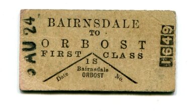
... railway was opened in 1916 to serve the agricultural and timber industry. Because of the decline in traffic and heavy operating costs, the line was finally closed in August, 1987. A rail motor which was used from 1924 – 1935, had the appearance of a motor bus on wheels. In October 1926 the rail motor service introduced from Bairnsdale to Orbost in May 1924 was in danger of being abandoned. The Victorian...railway was opened in 1916 to serve the agricultural and timber industry. Because of the decline in traffic and heavy operating costs, the line was finally closed in August, 1987. A rail motor which was used from 1924 – 1935, had the appearance of a motor bus on wheels. In October 1926 the rail motor service introduced from Bairnsdale to Orbost in May 1924 was in danger of being abandoned. The Victorian ...The Bairnsdale-Orbost railway was opened in 1916 to serve the agricultural and timber industry. Because of the decline in traffic and heavy operating costs, the line was finally closed in August, 1987. A rail motor which was used from 1924 – 1935, had the appearance of a motor bus on wheels. In October 1926 the rail motor service introduced from Bairnsdale to Orbost in May 1924 was in danger of being abandoned. The Victorian Railways Commissioners stated that patronage had not been satisfactory despite a one and a half hours reduction in the travel time.This item is associated with the history of the Orbost-Bairnsdale railway line and therefore reflects the role that the rail line played in the social and economic history of Orbost.A small cardboard first class train ticket - buff coloured with black print. It is from Bairnsdale to Orbost.orbost-bairnsdale-railway transport railway -
 Orbost & District Historical Society
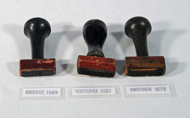
railway stamps, c. 1916-1987
... railway line which closed in 1987. The Bairnsdale-Orbost railway was opened in 1916 to serve the agricultural and timber industry. Because of the decline in traffic and heavy operating costs, the line was finally closed in August, 1987. This item is associated with the history of the Orbost-Bairnsdale railway line and therefore reflects the role that the rail line played in the social and economic history of Orbost. railway-stamp railway-history orbost-railway-line WAYGARA BRUTHEN ORBOST Three stamps used by Victorian Railways, for WAYGARA, BRUTHEN, and ORBOST stations. ...Used by station staff on the Bairnsdale to Orbost railway line which closed in 1987. The Bairnsdale-Orbost railway was opened in 1916 to serve the agricultural and timber industry. Because of the decline in traffic and heavy operating costs, the line was finally closed in August, 1987.This item is associated with the history of the Orbost-Bairnsdale railway line and therefore reflects the role that the rail line played in the social and economic history of Orbost.Three stamps used by Victorian Railways, for WAYGARA, BRUTHEN, and ORBOST stations. All stamps have black painted handles. The stamp is made of rubber and the handles are wood.WAYGARA BRUTHEN ORBOSTrailway-stamp railway-history orbost-railway-line -
 Orbost & District Historical Society
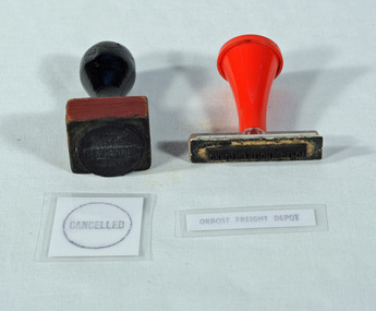
stamps, c. 1916-1987
... Used by Victorian Railways at the Orbost Railway Station. The line to Orbost closed in 1987....Orbost & District Historical Society Ruskin Street Orbost gippsland Used by Victorian Railways at the Orbost Railway Station. The line to Orbost closed in 1987. ...Used by Victorian Railways at the Orbost Railway Station. The line to Orbost closed in 1987.This item is associated with the history of the Orbost-Bairnsdale railway line and therefore reflects the role that the rail line played in the social and economic history of Orbost.Two stamps, one with a black handle, one with red handle. One is square and has the word CANCELLED within a circle. The other is rectangular in shape and has the words ORBOST FREIGHT DEPOT. CANCELLED ORBOST FREIGHT DEPOTrailway-history orbost-railway -
 Orbost & District Historical Society
ticket voucher book, Victorian Railways Commission, c. 1939 - 1987
... railway line between Bairnsdale and Orbost which closed in 1987. Escept for special events, passenger trains ceased in 1937 and after that time, passengers wishing to travel by train had to take the good trains and be issued with this ticket. The train guard may have issued these tickets. This item is associated with the history of the Orbost-Bairnsdale railway line and therefore reflects the role that the rail line played in the social and economic history of Orbost. railway-history orbost-bairnsdale-railway-line TR88 Victorian Railways BRUTHEN 6879 STATION 7/1/1939. ...A ticket voucher book used on the railway line between Bairnsdale and Orbost which closed in 1987. Escept for special events, passenger trains ceased in 1937 and after that time, passengers wishing to travel by train had to take the good trains and be issued with this ticket. The train guard may have issued these tickets.This item is associated with the history of the Orbost-Bairnsdale railway line and therefore reflects the role that the rail line played in the social and economic history of Orbost.A Victorian Railways ticket voucher book. This is a tear-off ticket book, stapled at the left margin. It was used for passengers travelling on goods trains from Bruthen Railway Station.TR88 Victorian Railways BRUTHEN 6879 STATION 7/1/1939. In consideration of my being able to travel by the ......goods train on the 7/1/39 from BRUTHEN 6879 to NOWA NOWA, I hereby unertake ........................... etc.railway-history orbost-bairnsdale-railway-line -
 Orbost & District Historical Society
railways envelope, Victorian Railways, c. 1970s-1980s
... railway line, and closed in 1987. The station was located on the west side of the Snowy River despite the town of Orbost being on the east side of the river, in order to save on the costs of a bridge over the river, which at the time had highly variable levels. This item is associated with the history of the Orbost-Bairnsdale railway line and therefore reflects the role that the rail line played in the social and economic history of Orbost. railway-history orbost-bairnsdale-railway 2498-78 VICTORIAN RAILWAYS From ORBOST to WESTALL Contents TIMBER An unused brown/buff coloured goods/freight consignment envelope used by Victorian Railways, this one for timber from Orbost to Westall. railways envelope Victorian Railways ...Used at Orbost railway station for the consignment of goods/freight, in this case, timber to Westall. The Bairnsdale-Orbost railway was opened in 1916 to serve the agricultural and timber industry. Because of the decline in traffic and heavy operating costs, the line was finally closed in August, 1987. Orbost Railway Station was opened on Monday 10 April 1916 as the terminus of the Orbost railway line, and closed in 1987. The station was located on the west side of the Snowy River despite the town of Orbost being on the east side of the river, in order to save on the costs of a bridge over the river, which at the time had highly variable levels. This item is associated with the history of the Orbost-Bairnsdale railway line and therefore reflects the role that the rail line played in the social and economic history of Orbost.An unused brown/buff coloured goods/freight consignment envelope used by Victorian Railways, this one for timber from Orbost to Westall. 2498-78 VICTORIAN RAILWAYS From ORBOST to WESTALL Contents TIMBER railway-history orbost-bairnsdale-railway -
 Orbost & District Historical Society
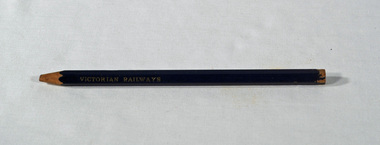
Victorian Railways pencil, Victorian Railways, c. 1960s-1980s
... Victorian Railways at stations on the Orbost-Bairnsdale line. The Bairnsdale-Orbost railway was opened in 1916 to serve the agricultural and timber industry. Because of the decline in traffic and heavy operating costs, the line was finally closed in August, 1987. ...Victorian Railways at stations on the Orbost-Bairnsdale line. The Bairnsdale-Orbost railway was opened in 1916 to serve the agricultural and timber industry. Because of the decline in traffic and heavy operating costs, the line was finally closed in August, 1987. ...Used by Victorian Railways at stations on the Orbost-Bairnsdale line. The Bairnsdale-Orbost railway was opened in 1916 to serve the agricultural and timber industry. Because of the decline in traffic and heavy operating costs, the line was finally closed in August, 1987. Orbost Railway Station was opened on Monday 10 April 1916 as the terminus of the Orbost railway line, and closed in 1987. The station was located on the west side of the Snowy River despite the town of Orbost being on the east side of the river, in order to save on the costs of a bridge over the river, which at the time had highly variable levels. This item is associated with the history of the Orbost-Bairnsdale railway line and therefore reflects the role that the rail line played in the social and economic history of Orbost.A thick, hexagonal shaped pencil made of wood, painted dark blue, containing blue graphite marker.VICTORIA RAILWAYS written in gold lettering Emperor, Made in Australia railway-history victorian-railways orbost-bairnsdale-railway -
 Orbost & District Historical Society
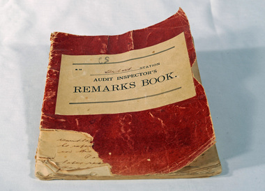
Victorian Railways remarks book, Victorian Railways, c. 1940s
... railway line, and closed in 1987. The station was located on the west side of the Snowy River despite the town of Orbost being on the east side of the river, in order to save on the costs of a bridge over the river, which at the time had highly variable levels. This item is associated with the history of the Orbost-Bairnsdale railway line and therefore reflects the role that the rail line played in the social and economic history of Orbost. railway-history orbost-bairnsdale-railway VICTORIAN RAILWAYS Audit Inspectors Remarks Book, Orbost. ...Used at Orbost Railway Station, possibly by the Station Master, between 1944 and 1984. The Bairnsdale-Orbost railway was opened in 1916 to serve the agricultural and timber industry. Because of the decline in traffic and heavy operating costs, the line was finally closed in August, 1987. Orbost Railway Station was opened on Monday 10 April 1916 as the terminus of the Orbost railway line, and closed in 1987. The station was located on the west side of the Snowy River despite the town of Orbost being on the east side of the river, in order to save on the costs of a bridge over the river, which at the time had highly variable levels. This item is associated with the history of the Orbost-Bairnsdale railway line and therefore reflects the role that the rail line played in the social and economic history of Orbost.Book with a red cover. On the front cover VICTORIAN RAILWAYS Audit Inspectors Remarks Book, Orbost. Inside are numbered and lined pages with hand written information dating from 28/3/1944-13/8/1984, dated and signed by various station masters. Cover has a section missing from the bottom left.VICTORIAN RAILWAYS Audit Inspectors Remarks Book, Orbost.railway-history orbost-bairnsdale-railway -
 Bright & District Historical Society operating the Bright Museum
Book, Victorian Railways, Instructions relating to Transportation of Goods, 1959
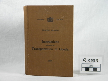
... Bright & District Historical Society operating the Bright Museum 2 Station Street Bright high-country This book was part of the working paraphernalia of the Bright railway station until it closed in 1978. manual 1959 victorian railways goods goods transportation traffic branch instructions railways transportation trucks goods trucks trains goods trains Hard material cover manual, brown, 410 pages, marked Victorian Railways with Victorian Government insignia, Traffic branch 1959 Instructions relating to Transportation of Goods Book Victorian Railways ...This book was part of the working paraphernalia of the Bright railway station until it closed in 1978.Hard material cover manual, brown, 410 pages, marked Victorian Railways with Victorian Government insignia, Traffic branch 1959manual, 1959, victorian railways, goods, goods transportation, traffic branch, instructions, railways, transportation, trucks, goods trucks, trains, goods trains -
 Eltham District Historical Society Inc
Photograph, Tess Justine (Nillumbik Shire Council), Murray's Bridge over the Diamond Creek, Eltham North, 19 Feb 2022
... Victorian Railways maps at the time show no such siding on Murray’s property. • In 1923 a new company was formed in anticipation of the old Diamond Creek Gold Mine being re-opened. The mine had been previously closed...Victorian Railways maps at the time show no such siding on Murray’s property. • In 1923 a new company was formed in anticipation of the old Diamond Creek Gold Mine being re-opened. The mine had been previously closed ...Murray's Bridge over the Diamond Creek on the Diamond Creek Trail just prior to demolition and replacement with a new steel bridge. Heritage advice obtained by Nillumbik Shire Council, following a suggestion by the Eltham District Historical Society (EDHS), is that the original bridge appears to have been a simplified version of the Country Roads Board’s (CRB) standard timber bridge design of the early-to-mid 1920s. In c1990 Murray’s bridge was renovated with three recycled steel girders as part of a bike/pedestrian path in the reserve. During these alterations many parts of the bridge were removed, and some were replaced. Heritage advice indicates the condition of Murray’s bridge is poor. The remaining original parts are all in poor condition, with severe weathering, splitting and rot, especially to the stringers retained on the bridge. Heritage advice is that Murray’s Bridge does not have sufficient significance in the cultural history of the Nillumbik area to warrant inclusion in the Nillumbik Shire Heritage Overlay and also does not have sufficient significance as a rare survivor to warrant inclusion in the Nillumbik Shire Heritage Overlay. There are no indications in the historical record that this site was individually important to the cultural history of this area. EDHS is comfortable with the heritage advice provided to Council and has worked closely on this project with Council. EDHS has suggested some of the removed timbers be used in the vicinity of the bridge for landscaping and possibly seating, so as to retain these remnants close to the site of the original bridge, which is the last old timber bridge along the lower reaches of the Diamond Creek. Mary (Sweeney) Murray and John Wright Murray selected 80 acres, Lot C Section 16 and Lot 5 Section 17 Parish of Nillumbik, under an occupation license in 1866. John died in 1867 and freehold was granted to his son John in 1873. The farm was known as ‘Laurel Hill’. John Junior was an Eltham Shire councillor and sometime president from 1887 up until 1897. He added Lot A Section 16 to the farm in ca1888. John and his younger brother James arranged to rent/purchase Lot B Section 17, across Diamond Creek to the west, in ca1900. It appears that John and James farmed separately for a few years, with a new homestead built for James ad family on the high point of Lot B Section 17 in ca1910. John sold off Lot 5 Section 17 in 1912. When John died in 1912 James took over the land on both sides of the Diamond Creek. The old homestead on the west side of the Creek disappeared. A farm bridge over Diamond Creek from this period may have been located close to the northern boundary of the farm. John Langlands, owner of the farm known as ‘Ihurst’ on the west side of Diamond Creek to the south of the Murray’s land, died in 1907. In 1909 his land was then subdivided into 100 lots to become the ‘Glen Park Estate’. Other similar subdivisions of nineteenth century farms around Eltham in this period included the ‘Franktonia (or Beard’s) Estate’ to the northeast and ‘Bonsack’s Estate’ between Eltham and Greensborough. Soon after the opening of the railway extension line from Eltham to Hurstbridge in 1912, Glen Park and nearby residents including James Murray agitated for a railway station or siding to be located half-way between Eltham and Hurstbridge, so that the Glen Park residents who used the railway daily did not have to walk into the Eltham or Hurstbridge stations. Some believed Coleman’s Corner (opposite Edendale Farm) was an appropriate spot for the platform. James Murray was among those who thought the railway should be located on his land, closer to half-way between Eltham and Hurstbridge stations. The Railways Commissioners warned that the locals would have to fund these works themselves. The Glen Park Estate residents initially had difficulty accessing Eltham by road, with only an old low-level bridge over Diamond Creek at the south end of their estate. A new timber trestle bridge across the creek, now on Wattletree Road, was opened in 1915. Road access to the north was gained in 1927 when the new Murray’s Road, which crossed the Murray’s land, was built. Residents continued to agitate for a Glen Park station. By 1926 the Railways Commissioners’ preferred site was on the Murray’s land. They arranged an estimate of cost of a full-length platform. The estimate was too much for the locals, who in 1928 argued unsuccessfully for a shorter and hence cheaper platform. By 1929 Murray had agreed to donate the land, but the locals would still have to fund the works. Murray decided, unilaterally it would appear, to commence work on a timber trestle road bridge over Diamond Creek to link the new Murray Road to the proposed station. Late in 1929 he stopped work on the bridge, for reasons unknown, but started work again and completed the bridge in 1931. There is no further newspaper evidence of the campaign for the Glen Park station until 1939, when Murray and another local, Mr Maxwell, met the Railways Commissioner. The Glen Park locale now included 45 homes on the west side of the creek and 20 on the Eltham side. Most of the residents used the train every day. The Commissioner remained adamant that only a full-length platform could be built for safety reasons. It appears the campaign dissolved at this point. The increasing move to cars may have had an impact. There is no evidence of Murray’s bridge ever being connected to Murray’s Road, or of it having wide use for any purpose by locals. James Murray died in 1947 and the farm was taken over by his son James (Jim). Jim started to sell off parts of the farm in the 1980s, retaining a few acres around the ca1910 homestead and building a new house there. Recreation reserves were established along the creek. In ca1990 Murray’s bridge was renovated with steel girders as part of a bike/pedestrian path in the reserve. The old farmhouse was demolished in ca2014. * * * A theory posted on local community Facebook groups was that the bridge was built in the 1860s and was built to be more robust than was necessary for the movement of cows from one side of the creek to the other. It was suggested the robustness was necessary to support the weight of gold ore being transferred from a mine on Murray’s land to a railway siding near Murrays Bridge (presumably for transfer and processing at Diamond Creek). Perhaps this may have been one of the motivators for Murray, who really knows? Knowing when mining operations ceased on his land and how that fits the overall timeline would be useful but at the time the bridge was built, local gold production was minimal at best. The known facts are: • The railway line came to Eltham in 1902. • The extension of the railway from Eltham to Hurstbridge was constructed in 1912 so no railway line even existed through Murray's property until 1912 and the Victorian Railways maps at the time show no such siding on Murray’s property. • In 1923 a new company was formed in anticipation of the old Diamond Creek Gold Mine being re-opened. The mine had been previously closed and flooded. It was noted in the press at the time that the mine was within a mile of the railway. Nothing really came of this. • Construction of Murrays Bridge was commenced by James Murray in early 1929 in anticipation of a proposed flag station being nominated on his land, but work ceased shortly afterwards. The proposed flag station was commonly referred to as Glen Park as the residents of the Glen Park Estate wanted Option 1, located near them with the platform adjacent to Colemans corner. This was probably never going to fly as it was virtually in eyesight of Eltham station. Allandale Road was the third option, but the Commissioners' preferred option was No. 2 - on Murray's property. • The Railway Commissioners were not going to finance any such station and the works had to be funded by private landowners and residents, hence Murray investing in this himself. • Murray recommenced work two years later and finished his bridge in 1931 but unfortunately for him, the proposed flag station never eventuated. The bluestone siding you reference may well have been built by Murray as part of the proposed station platform. • Up until then, apart from the Main Road bridge, which was washed away in 1924, virtually all local crossings over the Diamond Creek were low lying bridges – Kaylocks Bridge at Brougham Street, Diamond Street bridge, Glen Park Road bridge. It is expected that Murray also had a low-lying bridge to connect his land either side of the creek. These were all washed away or severely damaged multiple times in the 1920s. Lessons were learnt, and Murrays Bridge appears to have been built in accordance with Country Road Board standards of the time. Flood damage was ongoing, and even more recently constructed raised bridges kept getting washed away, e.g., the new Wattle Tree Road bridge in 1958 just months after completion. Murray’s bridge was reinforced with steel some 30 years ago presumably to provide additional floodwater resistance, given the history of bridges disappearing in floodwaters. • In March 1932 it was reported in the Advertiser that there were still some prospectors operating around Eltham North who apart from further scarring the face of the earth over the previous two years had gained significant experience but little gold - hardly a driving factor for constructing a dedicated railway siding and bridge to transfer gold ore. It is far more probable that James Murray was hoping to have the railway station located on his property and invested his money by building the bridge to lead to it as well as a station platform. Had the station eventuated, it may well have driven up the value of his land for subdivision and new housing estates like the Glen Park Estate. That did not eventuate. Whilst the bridge was indeed old (90 years), the core structure being completed in 1931, it had been modified substantially from original and hence had no significant historic value – i.e., it was not a representative example of its type, construction, and age. Given that the bridge was not worthy of saving, the Eltham District Historical Society with Council’s support, and the Eltham Woodworkers group endeavoured to see what suitable sized timbers were salvageable to fabricate a commemorative seat. Unfortunately, the experts at the Woodworkers group were unable to salvage any suitable length/width timbers to fabricate the seat due to the presence of rot. Last remaining wooden trestle bridge on the Diamond Creek Trail just prior to demolition and replacementBorn digital image (27)diamond creek (creek), diamond creek trail, murrays bridge, ‘laurel hill’, john wright murray, mary (sweeney) murra, john murray jnr, james murray, john langlands, ‘ihurst’, ‘glen park estate’, beard's estate, franktonia, bonsack's estate, glen park estate, glen park railway station -
 Glen Eira Historical Society
Album - Album page, Neerim Road, Circa 1972
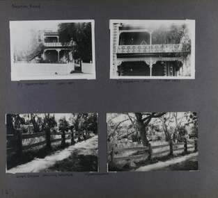
... The Outer Circle Railway's Oakleigh section opened 1890 and closed 1895. Victorian Heritage database (as of 26/10/2021) HO45 Edenkillie https://vhd.heritagecouncil.vic.gov.au/places/35545 "Edenkillie" at 37 Neerim Road, Glenhuntly, is a substantial two storeyed polychrome brick villa, built for Frederick Jowett, municipal secretary, in 1890. ...This photograph is part of the Caulfield Historical Album 1972. This album was created in approximately 1972 as part of a project by the Caulfield Historical Society to assist in identifying buildings worthy of preservation. The album is related to a Survey the Caulfield Historical Society developed in collaboration with the National Trust of Australia (Victoria) and Caulfield City Council to identify historic buildings within the City of Caulfield that warranted the protection of a National Trust Classification. Principal photographer thought to be Trevor Hart, member of Caulfield Historical Society. Most photographs were taken between 1966-1972 with a small number of photographs being older and from unknown sources. All photographs are black and white except where stated, with 386 photographs over 198 pages. "Edenkillie" was the home of Frederick Jowett, Caulfield's shire secretary and town clerk from 1887 to 1921. The Outer Circle Railway's Oakleigh section opened 1890 and closed 1895. Victorian Heritage database (as of 26/10/2021) HO45 Edenkillie https://vhd.heritagecouncil.vic.gov.au/places/35545 "Edenkillie" at 37 Neerim Road, Glenhuntly, is a substantial two storeyed polychrome brick villa, built for Frederick Jowett, municipal secretary, in 1890. It has aesthetic, historical and social significance. "Edenkillie's" aesthetic value derives from its survival as a substantially intact example of a common villa form expressed in polychrome brickwork. Its historical significance lies in its association with Frederick Jowett, Shire of Caulfield secretary and town clerk for over three decades. Its social significance is derived from the building's ability to demonstrate the kind of lifestyle which a local government administrator could enjoy during the Land Boom.Page 145 of Photograph Album with four landscape photographs from Neerim Road: two photographs of No 37 and two of the Outer Circle Railway Reserve.Handwritten: Neerim Road [top left] / 37 NEERIM ROAD 1OCT 1972 [under top left photo] / 37 NEERIM RD 1 OCT 1972 [under top right photo] / OUTER CIRCLE RAILWAY RESERVE MURRUMBEENA [under bottom left photo] / 145 [bottom left]trevor hart, neerim road, murrumbeena, caulfield, edenkillie, glen huntly, polychrome brick, mansions, frederick jowett, town clerks, shire of caulfield, outer circle railway, railways, parks and reserves, outer circle railway reserve, cast iron work, verandahs, balconies -
 Eltham District Historical Society Inc
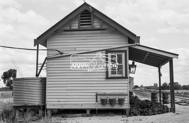
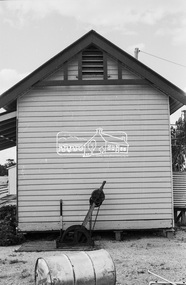
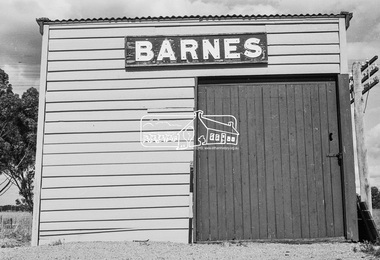
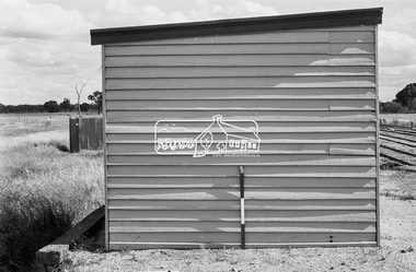
Photograph, Barnes Railway Station, Moama, NSW, c.November 1962, 1962
... This section was taken over by Victorian Railways in 1923, as part of the 1922 Border Railways Act. Barnes station was closed in 1979. ...This section was taken over by Victorian Railways in 1923, as part of the 1922 Border Railways Act. Barnes station was closed in 1979. ...The railway reached Echuca in 1864 and transformed the town into a major river port, with a famous wharf and substantial urban growth in the 1870s. In 1876 the Deniliquin and Moama Railway Company opened its 71 km (44 mi) private railway northwards to Barnes and Deniliquin, and the line at Echuca was extended across the Murray River into Moama to join the railway. This section was taken over by Victorian Railways in 1923, as part of the 1922 Border Railways Act. Barnes station was closed in 1979. Deniliquin railway line https://en.wikipedia.org/wiki/Deniliquin_railway_lineDigital TIFF file Scan of 35mm Ilford FP3 black and white negative transparencybarnes railway station, echuca, george coop collection, moama -
 Eltham District Historical Society Inc
Photograph, Barnes Railway Station, Moama, NSW, November 1962
... This section was taken over by Victorian Railways in 1923, as part of the 1922 Border Railways Act. Barnes station was closed in 1979. ...This section was taken over by Victorian Railways in 1923, as part of the 1922 Border Railways Act. Barnes station was closed in 1979. ...Barnes station building photographed in November 1962. The railway reached Echuca in 1864 and transformed the town into a major river port, with a famous wharf and substantial urban growth in the 1870s. In 1876 the Deniliquin and Moama Railway Company opened its 71 km (44 mi) private railway northwards to Barnes and Deniliquin, and the line at Echuca was extended across the Murray River into Moama to join the railway. This section was taken over by Victorian Railways in 1923, as part of the 1922 Border Railways Act. Barnes station was closed in 1979. Deniliquin railway line https://en.wikipedia.org/wiki/Deniliquin_railway_lineDigital TIFF file Scan of 35mm Ilford FP3 black and white negative transparencybarnes railway station, echuca, george coop collection, moama -
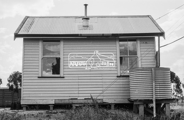
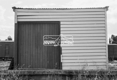
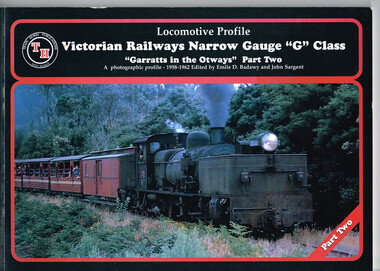 Otway Districts Historical Society
Book, Train Hobby Publications, Victorian Railways Narrow Gauge, Part 2, March 1999
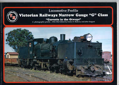
... closed. Colac; Beech Forest; Crowes; Garratt; Victorian Railways; narrow gauge; Emile D. ...An historical series setting out Garratt engines and running stock running between Colac and Crowes (just past Lavers Hill), and then between Colac and Beech Forest in the Otways between 1958 and 1962 when the line closed.Victorian Railways Narrow Gauge "G" Class. "Garratts in the Otways" Part Two. A photographic profile - 1958-1962. Emile D. Badawy (ed.); John Sargent (ed.). 1999; Train Hobby Publications. ii, 56 p.; illus., map. Soft cover. colac; beech forest; crowes; garratt; victorian railways; narrow gauge; emile d. badawy; john sargent; -
 Otway Districts Historical Society
Book, Train Hobby Publications, Victorian Railways Narrow Gauge, Part 1, March 1998
... The first in an historical series showing the Victorian Railway narrow gauge line from Colac to Crowes, and then from Colac to Beech Forest, in the Otways from 1954 until 1962 when the line closed....Otway Districts Historical Society Cliff Young Drive Beech Forest great-ocean-road The first in an historical series showing the Victorian Railway narrow gauge line from Colac to Crowes, and then from Colac to Beech Forest, in the Otways from 1954 until 1962 when the line closed. ...The first in an historical series showing the Victorian Railway narrow gauge line from Colac to Crowes, and then from Colac to Beech Forest, in the Otways from 1954 until 1962 when the line closed.Victorian Railways Narrow Gauge "G" Class. "Garratts in the Otways" Part One. A photographic profile - 1954-1962. Emile D. Badawy (ed.); John Sargent (ed.). 1998; Train Hobby Publications; Studfield (Vic). ii, 48 p.; illus., maps. Soft cover.colac; beech forest; crowes; victorian railways; garratt; narrow gauge; emile d. badawy; john sargent; -
 Otway Districts Historical Society
Book, Victorian Railways Narrow Gauge, Part Three, March 2001
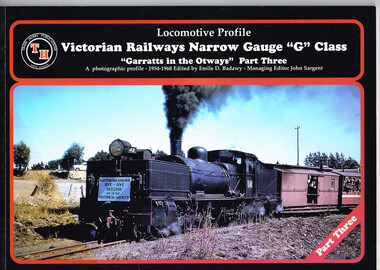
... The third in the historical series outlining the narrow gauge Victorian Railways line from Colac to Crowes, and then Colac to Beech Forest, in the Otways between 1954 and 1962 when the line closed. ...Otway Districts Historical Society Cliff Young Drive Beech Forest great-ocean-road The third in the historical series outlining the narrow gauge Victorian Railways line from Colac to Crowes, and then Colac to Beech Forest, in the Otways between 1954 and 1962 when the line closed. ...The third in the historical series outlining the narrow gauge Victorian Railways line from Colac to Crowes, and then Colac to Beech Forest, in the Otways between 1954 and 1962 when the line closed. Victorian Railways Narrow Gauge "G" Class; "Garratts in the Otways" Part Three. A photographic profile - 1954-1968. Emile D. Badawy (ed.). 2001; Train Hobby Publications; Studfield (Vic). ii, 48 p.; illus. Soft cover. ISBN 1 876249 41 2colac; beech forest; crowes; victorian railways; narrow gauge; garratt; emile d. badawy; -
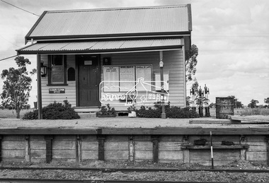
 Otway Districts Historical Society
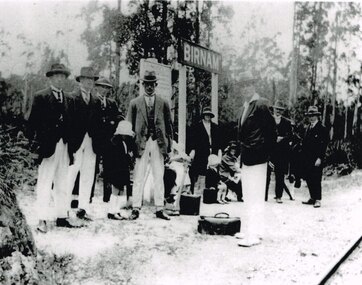
Photograph, Birnam Station, c.1926, c.1926
... After a nearby mill closed down the Cashin family, who lived south of the mill site, requested Victorian Railways to keep the siding open for passenger use, which it did, but changed the name to Birnam in 1926. ...Otway Districts Historical Society Cliff Young Drive Beech Forest great-ocean-road After a nearby mill closed down the Cashin family, who lived south of the mill site, requested Victorian Railways to keep the siding open for passenger use, which it did, but changed the name to Birnam in 1926. ...After a nearby mill closed down the Cashin family, who lived south of the mill site, requested Victorian Railways to keep the siding open for passenger use, which it did, but changed the name to Birnam in 1926. In 1927 it was moved south a little distance, closer to the houses it served. From left to right, awaiting the train, are the people it served, Tom Cashin, Ted Cashin, Arthur Cashin, the child Eva Facey, Jim Cashin, Sarah Cashin, the second child, Doris Hansen, Beatrice Hansen (nee Cashin), Bert Hansen, Jim Facey and Percy Facey. It was regularly patronised until 1939 after which it saw little use.B/W. 195mm x 250mm. At Birnam Station in c.1926, seven men, one with covered axe, three women and two children, awaiting the train.birnam; railways; tom cashin; ted cashin; arthur cashin; eva facey; jim cashin; sarah cashin; doris hansen; beatrice hansen; bert hansen; jim facey; percy facey; -
 Otway Districts Historical Society
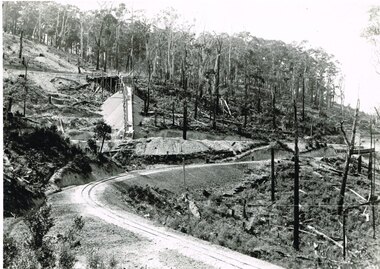
Photograph, Victorian Railways, Gellibrand ballast pit siding, c.1902
... By the mid-1920s the Victorian Railways found it more economic to use ballast from Penshurst, so the siding was closed by 1925 and the rails lifted....By the mid-1920s the Victorian Railways found it more economic to use ballast from Penshurst, so the siding was closed by 1925 and the rails lifted. gellibrand; gellibrand siding; railways; B/W. ...In 1902 a ballast siding was opened 4 km south of Gellibrand to provide materials for track construction. A spur siding with a capacity for six trucks was cut into the side of a slope. Above this was erected a loading bin and chute. The stone proved to be of durable quality so the siding continued after 1902 for periodic track re-ballasting works. The points were set for the main line and spiked shut when the siding was not in use. By the mid-1920s the Victorian Railways found it more economic to use ballast from Penshurst, so the siding was closed by 1925 and the rails lifted.B/W. Gellibrand ballast pit siding at 19 miles (30.6 km) south of Colac. gellibrand; gellibrand siding; railways;