Showing 35 items matching "coastline - south coast"
-
 Phillip Island and District Historical Society Inc.
Photograph, Unknown
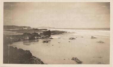
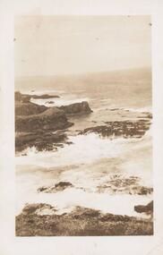
... coastline...south coast phillip island...Batty phillip island coastline south coast phillip island phillip island m batty Black & White photograph of the South Coast of Phillip Island. ...One of 6 photographs donated by M. BattyBlack & White photograph of the South Coast of Phillip Island.phillip island coastline, south coast phillip island, phillip island, m batty -
 Phillip Island and District Historical Society Inc.
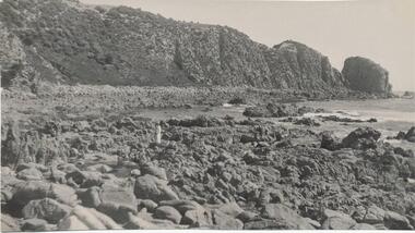
Photograph, Unknown
... ...coastline - south coast...Phillip Island and District Historical Society Inc. phillip-island-and-the-bass-coast One of 6 photograph donated by M. Batty phillip island coastline coastline - south coast rocky outcrock phillip island phillip island m batty Black & White photograph of South Coast of Phillip Island with rocky outcrop. ...One of 6 photograph donated by M. BattyBlack & White photograph of South Coast of Phillip Island with rocky outcrop.phillip island coastline, coastline - south coast, rocky outcrock phillip island, phillip island, m batty -
 Phillip Island and District Historical Society Inc.
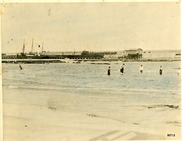
Photograph, 01/1938
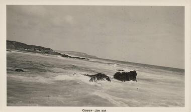
... coastline...south coast phillip island...Phillip Island and District Historical Society Inc. phillip-island-and-the-bass-coast One of 8 photographs donated by Joseph White phillip island coastline south coast phillip island shoreline phillip island joseph white "Cowes - Jan 1938" Black & White photograph of the South Coast of Phillip Island Photograph Photograph Photo Shop ...One of 8 photographs donated by Joseph WhiteBlack & White photograph of the South Coast of Phillip Island"Cowes - Jan 1938"phillip island coastline, south coast phillip island, shoreline phillip island, joseph white -
 Phillip Island and District Historical Society Inc.
Photograph, Early 20th Century
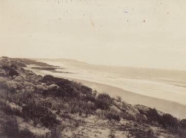
... coastline...south coast phillip island...Phillip Island and District Historical Society Inc. phillip-island-and-the-bass-coast One of a collection of 6 photographs donated by Mary Karney phillip island coastline south coast phillip island mary karney Black & White photograph of the South Coast of Phillip Island Photograph Photograph ...One of a collection of 6 photographs donated by Mary KarneyBlack & White photograph of the South Coast of Phillip Islandphillip island coastline, south coast phillip island, mary karney -
 Phillip Island and District Historical Society Inc.
Photograph, Early 20th Century
... coastline...south coast phillip island...Winn phillip island coastline south coast phillip island coastal f winn Sepia photograph of the South Coastline of Phillip Island with waves crashing on the rocks. ...One of a collection of 9 photographs donated by F. WinnSepia photograph of the South Coastline of Phillip Island with waves crashing on the rocks.phillip island coastline, south coast phillip island, coastal, f winn -
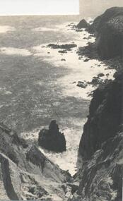
 Phillip Island and District Historical Society Inc.
Photograph, Bryant West
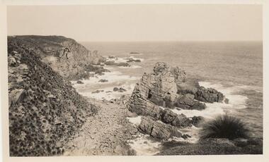
... ...coastline - south coast...Phillip Island and District Historical Society Inc. phillip-island-and-the-bass-coast One of a collection of over 400 photographs in an album commenced in 1960 and presented to the Phillip Island & Westernport Historical Society by the Shire of Phillip Island local history photography photographs coastline - south coast south coast cliffs south coast phillip island john jenner bryant west Photograph from cliff top of rocky south coastline looking easterly Photograph Bryant West ...One of a collection of over 400 photographs in an album commenced in 1960 and presented to the Phillip Island & Westernport Historical Society by the Shire of Phillip IslandPhotograph from cliff top of rocky south coastline looking easterlylocal history, photography, photographs, coastline - south coast, south coast, cliffs, south coast phillip island, john jenner, bryant west -
 Phillip Island and District Historical Society Inc.
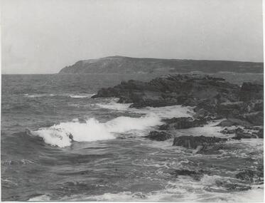
Photograph, Bryant West
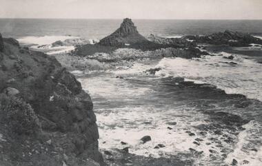
... coastline...south coast...Phillip Island and District Historical Society Inc. phillip-island-and-the-bass-coast One of a collection of over 400 photographs in an album commenced in 1960 and presented to the Phillip Island & Westernport Historical Society by the Shire of Phillip Island local history photography photographs coastline - rock formation - pyramid rock coastline south coast pyramid rock john jenner bryant west Photograph of Pyramid Rock looking south from cliff top Photograph Bryant West ...One of a collection of over 400 photographs in an album commenced in 1960 and presented to the Phillip Island & Westernport Historical Society by the Shire of Phillip IslandPhotograph of Pyramid Rock looking south from cliff toplocal history, photography, photographs, coastline - rock formation - pyramid rock, coastline, south coast, pyramid rock, john jenner, bryant west -
 Warrnambool and District Historical Society Inc.
Audio Visual, Warrnambool Video Productions, Video - Winter Visitors, 1999
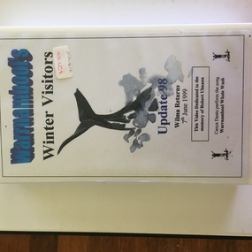
... Warrnambool and District Historical Society Inc. 2 Gilles Street (south of Merri St) Warrnambool great-ocean-road This videotape has material related to the annual arrival in Warrnambool’s coast (mainly at Logan’s Beach) of Southern Right Whales. These whales come annually to the Western District coastline ...This videotape has material related to the annual arrival in Warrnambool’s coast (mainly at Logan’s Beach) of Southern Right Whales. These whales come annually to the Western District coastline about May and stay until about October. and some calve at Logan’s Beach – hence the name Logan’s Beach Whale Nursery. The whales have become an important tourist attraction in the area. Most of the whales return to the area regularly and have been named from their particular markings. Wilma the whale was a great favourite and was seen about every three years in Warrnambool but is now appearing in other parts of Australia. The tape is dedicated to Robert Ulmann who was a well-known artist and conservationist in the Warrnambool region. He did much to ensure the whales received protection and publicity in the Warrnambool environment. This tape is now in an outdated format and will be transferred to a more appropriate form as the material in it needs to be preserved. The whale migration to Warrnambool is a significant natural history event and material from the 1990s is important. This is a videotape in a black case with a white label with black printing pasted on. The outer box is white with a white label with blue and black printing. An image of a whale is on the outer label. ‘Warrnambool’s Winter Visitors’ ‘Update 98 Wilma Returns 7thJune 1999’ ‘This video dedicated to the memory of Robert Ulmann’ ‘Canya Dantz perform the song, Warrnambool Whale Wash’ whales in warrnambool, robert ulmann -
 Warrnambool and District Historical Society Inc.
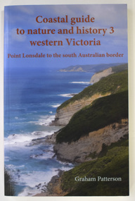
Book - Coastal Western Victoria, Graham Patterson, Coastal Guide to Nature and History 3 Western Victoria, 2022
... south of Merri St) Warrnambool great-ocean-road This book by Graham Patterson contains details on the coastline in Victoria from Point Lonsdale to the South Australian Border. Information is given on the landforms, geology, history, coastal management and animals and plants. This book is of some considerable interest, particularly as it includes information on Warrnambool and its coastal environs. Western Victoria coastline Graham Patterson warrnambool shipwreck coast ...Description of Western Victorian Coast from Point Lonsdale to South Australian BorderThis is a book of 188 pages. The cover has colour photographs and printing in red and white. The pages contain printed text, maps and illustrations, and black and white and colour photographsnon-fictionDescription of Western Victorian Coast from Point Lonsdale to South Australian Borderwestern victoria coastline, graham patterson, warrnambool, shipwreck coast -
 Warrnambool and District Historical Society Inc.
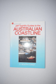
Book, Hodder & Stoughton (Australia) Pty Ltd, Australian Coast Line, 1987
... south coast of Australia. It contains potted histories and information for tourists. Some of the information regarding places to stay and recreational facilities etc will date over the years and the book will be of less use. This book is of minor interest as a summary of the places along the coastline ...This book details the places and towns along the south coast of Australia. It contains potted histories and information for tourists. Some of the information regarding places to stay and recreational facilities etc will date over the years and the book will be of less use.This book is of minor interest as a summary of the places along the coastline of Victoria and as a useful resource book in our library.This s a soft-cover book of 128 pages. It has a blue cover with a colour photograph and red and white printing on the front cover and a colour photograph of the author and black printing on the back cover. The pages contain printed material, black and white photographs and maps and sketches. coastline of victoria, history of warrnambool -
 Warrnambool and District Historical Society Inc.
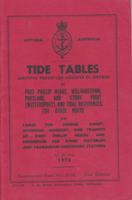
Booklet, Tide Tables, For the year 1976
... Warrnambool and District Historical Society Inc. 2 Gilles Street (south of Merri St) Warrnambool great-ocean-road Yearly publication showing predicted heights in metres for Port Phillip Heads, Williamstown, Portland and Stony Point (Westernport) and tidal differences for other Ports.This booklet provides tide and port information for the coastline of Victoria for the year 1976. It also has information on other aspects of weather such as wind, cloud and sea descriptions. These booklets were a useful reference for fishermen and those involved in boating along the coast ...Yearly publication showing predicted heights in metres for Port Phillip Heads, Williamstown, Portland and Stony Point (Westernport) and tidal differences for other Ports.This booklet provides tide and port information for the coastline of Victoria for the year 1976. It also has information on other aspects of weather such as wind, cloud and sea descriptions. These booklets were a useful reference for fishermen and those involved in boating along the coast of Victoria. They are published in digital form today.Sold at Stan McPhee Sports store Liebig St Warrnambool Vic showing local tides. Red card wrap around cover. 92 cream coloured pages held with 2 staples. Black print. Ports and harbour seal on the frontBooksellers stamp: ink. blue Stan McPhee Sports, green Liebig St Vic. red ...2953. 6717/75. C.H. Rixon, Government Printer, Melbourne. 51st Edition. Recommended price $3.00. Tables for Sunrise, Sunset/moonrise, moonset and transits at Port Phillip Heads & differences for other Victorian and Tasmanian Lighthouse stations.tide table, warrnambool tide table 1976, southern victorian tides -
 Phillip Island and District Historical Society Inc.
Photograph, Bryant West
... Phillip Island and District Historical Society Inc. phillip-island-and-the-bass-coast One of a collection of over 400 photographs in an album commenced in 1960 and presented to the Phillip Island & Westernport Historical Society by the Shire of Phillip Island local history photography photographs coastline cape woolamai phillip island john jenner bryant west Photograph of Cape Woolamai looking south east. ...One of a collection of over 400 photographs in an album commenced in 1960 and presented to the Phillip Island & Westernport Historical Society by the Shire of Phillip IslandPhotograph of Cape Woolamai looking south east.local history, photography, photographs, coastline, cape woolamai, phillip island, john jenner, bryant west -
 Phillip Island and District Historical Society Inc.
Photograph, Bryant West
... Phillip Island and District Historical Society Inc. phillip-island-and-the-bass-coast One of a collection of over 400 photographs in an album commenced in 1960 and presented to the Phillip Island & Westernport Historical Society by the Shire of Phillip Island local history photography photographs coastline rocky beach reef cape woolamai phillip island reefs john jenner bryant west Photograph of Rocks and Beach south side of Cape Woolamai. ...One of a collection of over 400 photographs in an album commenced in 1960 and presented to the Phillip Island & Westernport Historical Society by the Shire of Phillip IslandPhotograph of Rocks and Beach south side of Cape Woolamai.local history, photography, photographs, coastline, rocky beach, reef, cape woolamai, phillip island, reefs, john jenner, bryant west -
 Phillip Island and District Historical Society Inc.
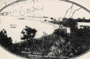
Photograph
... Phillip Island and District Historical Society Inc. phillip-island-and-the-bass-coast One of a collection of over 400 photographs in an album commenced in 1960 and presented to the Phillip Island & Westernport Historical Society by the Shire of Phillip Island local history photography photographs fowlers bay newhaven black & white photograph phillip island coastline fowlers bay newhaven san remo John Jenner Bryant West Photograph of Fowlers Bay, Newhaven, taken looking south-east and showing some moored boats. ...One of a collection of over 400 photographs in an album commenced in 1960 and presented to the Phillip Island & Westernport Historical Society by the Shire of Phillip IslandPhotograph of Fowlers Bay, Newhaven, taken looking south-east and showing some moored boats. The Newhaven jetty and San Remo in the background.local history, photography, photographs, fowlers bay, newhaven, black & white photograph, phillip island coastline, fowlers bay newhaven, san remo, john jenner, bryant west -
 Phillip Island and District Historical Society Inc.
Photograph, Bryant West
... Phillip Island and District Historical Society Inc. phillip-island-and-the-bass-coast One of a collection of over 400 photographs in an album commenced in 1960 and presented to the Phillip Island & Westernport Historical Society by the Shire of Phillip Island local history photography photographs coastline eastern channel phillip island cape woolamai john jenner bryant west Photograph of Cape Woolamai looking south west across the Eastern Passage. ...One of a collection of over 400 photographs in an album commenced in 1960 and presented to the Phillip Island & Westernport Historical Society by the Shire of Phillip IslandPhotograph of Cape Woolamai looking south west across the Eastern Passage.local history, photography, photographs, coastline, eastern channel, phillip island, cape woolamai, john jenner, bryant west -
 Phillip Island and District Historical Society Inc.
Photographs, 1998
... Phillip Island and District Historical Society Inc. phillip-island-and-the-bass-coast A group of photographs donated by Henrietta Da Costa, Telopa, NSW - in order to retain local history of Phillip Island. the nobbies phillip island south coast phillip island the blowhole phillip island farmland ventnor phillip island henrietta da costa Eleven coloured photographs of The Nobbies area and coastline and Ventnor farmland. ...A group of photographs donated by Henrietta Da Costa, Telopa, NSW - in order to retain local history of Phillip Island.Eleven coloured photographs of The Nobbies area and coastline and Ventnor farmland.the nobbies phillip island, south coast phillip island, the blowhole phillip island, farmland ventnor phillip island, henrietta da costa -
 Phillip Island and District Historical Society Inc.
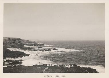
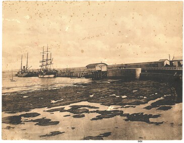
Photograph, South Coast Phillip Island, Feb 1939
... Phillip Island and District Historical Society Inc. phillip-island-and-the-bass-coast One of a collection of 18 photographs and postcards donated by Jill Yeoman southcoast phillip island phillip island coastline coastline phillip island jill yeoman Cowes Feb 1939 Black & White photograph of the Southcoast Phillip Island - near Summerland South Coast Phillip Island Photograph Photograph Photo Shop Series ...One of a collection of 18 photographs and postcards donated by Jill YeomanBlack & White photograph of the Southcoast Phillip Island - near SummerlandCowes Feb 1939southcoast phillip island, phillip island coastline, coastline phillip island, jill yeoman -
 Phillip Island and District Historical Society Inc.
Photograph, Early 20th Century
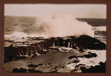
... south coast phillip island...breaking waves...phillip island coastline...Phillip Island and District Historical Society Inc. phillip-island-and-the-bass-coast One of a collection of 13 photographs donated by Ralph Correy. rock formations south coast phillip island breaking waves phillip island coastline ralph correy Black & White photograph of waves breaking over a rock platform near The Nobbies. ...One of a collection of 13 photographs donated by Ralph Correy.Black & White photograph of waves breaking over a rock platform near The Nobbies.rock formations, south coast phillip island, breaking waves, phillip island coastline, ralph correy -
 Phillip Island and District Historical Society Inc.
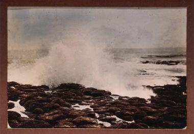
Photograph, Early 20th Century
... south coast phillip island...phillip island coastline...Phillip Island and District Historical Society Inc. phillip-island-and-the-bass-coast One of a collection of 13 photographs donated by Ralph Correy. breaking waves south coast phillip island phillip island coastline ralph correy Black & White photograph of waves breaking over the rocks - probably near The Nobbies. ...One of a collection of 13 photographs donated by Ralph Correy.Black & White photograph of waves breaking over the rocks - probably near The Nobbies.breaking waves, south coast phillip island, phillip island coastline, ralph correy -
 Phillip Island and District Historical Society Inc.
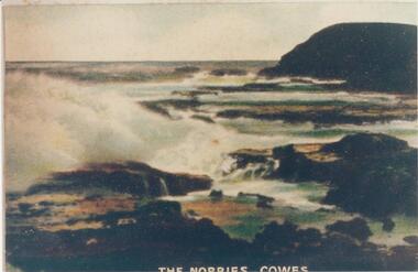
Photograph, Early 20th Century
... ...south coast phillip island...coastline...Phillip Island and District Historical Society Inc. phillip-island-and-the-bass-coast One of a collection of photographs donated by Bruce Bennett the nobbies phillip island rock formation phillip island south coast phillip island coastline phillip island bruce bennett "The Nobbies - Cowes" Coloured copy of a postcard. ...One of a collection of photographs donated by Bruce BennettColoured copy of a postcard. Rock platform with breakers and Nobbies at top right."The Nobbies - Cowes"the nobbies phillip island, rock formation phillip island, south coast phillip island, coastline phillip island, bruce bennett -
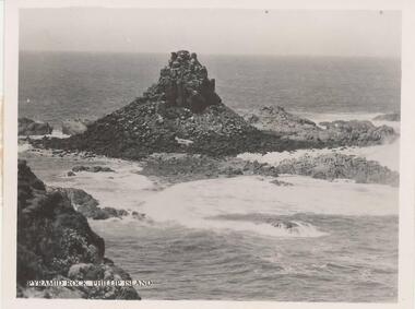 Phillip Island and District Historical Society Inc.
Photograph, 1940's - 1950's
... coast One of a collection of 9 photographs donated by the former Shire of Phillip Island. One of a series of photographs sold as a pack of 7 postcards for tourists/visitors to Phillip Island. coastline - rock formation - pyramid rock pyramid rock pyramid rock phillip island phillip island coastline shire of phillip island "Pyramid Rock, Phillip Island" Black & White photograph - view of Pyramid Rock from South Pint - close-up view. ...One of a collection of 9 photographs donated by the former Shire of Phillip Island. One of a series of photographs sold as a pack of 7 postcards for tourists/visitors to Phillip Island.Black & White photograph - view of Pyramid Rock from South Pint - close-up view."Pyramid Rock, Phillip Island"coastline - rock formation - pyramid rock, pyramid rock, pyramid rock phillip island, phillip island coastline, shire of phillip island -
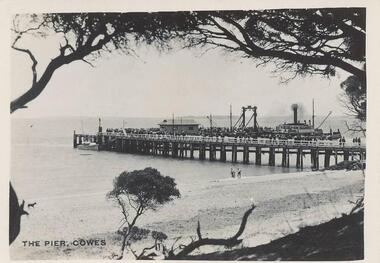 Phillip Island and District Historical Society Inc.
Photographs, Photo Shop Series, 1940
... Phillip Island and District Historical Society Inc. phillip-island-and-the-bass-coast A collection of 18 photographs taken by Mrs Haines' sister whilst on an excursion to Phillip Island from Mt Barker High School in South Australia. cowes pier phillip island the killara ferry ferries wildlife - seals wildlife - koala suspension bridge phillip island phillip island coastline smith's beach lover's walk cowes lover's walk cowes phillip island war memorial cowes phillip island seals on seal rocks phillip island seal rocks phillip island mrs haines 217-01 Photograph of the Cowes Pier taken from foreshore. ...A collection of 18 photographs taken by Mrs Haines' sister whilst on an excursion to Phillip Island from Mt Barker High School in South Australia. 217-01 Photograph of the Cowes Pier taken from foreshore. Ferry at centre left and crowd of people on end of pier. 217-02 Photograph taken from the end of the Cowes Pier with Isle of Wight Hotel in the background. 217-03 Photograph of the Killara Ferry leaving Cowes with a crowd of people on board. 217-04 Photograph of waves surging over Bridal Veil rock platform in foreground. 217-05 Photograph of wave breaking over rock platform on the South Coast of Phillip Island. 217-06 Photograph of the Suspension Bridge from San Remo. 217-07 Photograph of a Guesthouse Dining Room. Tables covered with white cloth and fully laid, including floral arrangements. 217-08 Photograph of the War Memorial at Cowes with the pier in background. 217-09 Photograph of seals on Seal Rocks Phillip Island. 217-10 Photograph of a koala on the trunk of a Gum Tree. Handwritten on the back of the photo - "Roberta, a pet koala". 217-11 Photograph of children rolling down dune onto the beach. Children and adults standing at water's edge. 217-12 Photograph of the Killara at San Remo taken from the Suspension Bridge. 217-13 Photograph of a group of school children with teachers, young girl in the foreground, on rocks at Smith's Beach. 217-14 Photograph looking along the Suspension bridge from Newhaven end. Group of people walking toward San Remo. 217-15 Photograph of Suspension bridge from Newhaven beach. 217-16 Photograph of Mrs Melbourne and Mrs Haines sister. 217-17 Photograph of Seal Rocks taken from a boat. 217-18 Photograph of Theni Beddams - Headmistress of Shelford and Ila Tattersall (Mrs Haines) Sybil Robinson's sister together with four sailors.cowes pier phillip island, the killara ferry, ferries, wildlife - seals, wildlife - koala, suspension bridge phillip island, phillip island coastline, smith's beach, lover's walk cowes, lover's walk cowes phillip island, war memorial cowes phillip island, seals on seal rocks phillip island, seal rocks phillip island, mrs haines -
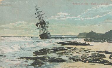 Phillip Island and District Historical Society Inc.
Photograph - Post Card, 1906
... Phillip Island and District Historical Society Inc. phillip-island-and-the-bass-coast One of a collection of photographs donated by Shirley Peterson. wreck of the sailing ship "speke" phillip island coastline phillip island shirley peterson "Wreck of the "Speke", Cowes" "Robb Bros. Cowes" Colour postcard of the wreck of the :Speke" on the south ...One of a collection of photographs donated by Shirley Peterson.Colour postcard of the wreck of the :Speke" on the south coast of Phillip Island in 1906."Wreck of the "Speke", Cowes" "Robb Bros. Cowes"wreck of the sailing ship "speke", phillip island coastline, phillip island, shirley peterson -
 Phillip Island and District Historical Society Inc.
Photograph, Bryant West
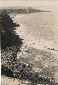
... Phillip Island and District Historical Society Inc. phillip-island-and-the-bass-coast One of a collection of over 400 photographs in an album commenced in 1960 and presented to the Phillip Island & Westernport Historical Society by the Shire of Phillip Island local history photography photographs coastline phillip island southern coastline phillip island john jenner bryant west Photograph of Rocky south coast shoreline. ...One of a collection of over 400 photographs in an album commenced in 1960 and presented to the Phillip Island & Westernport Historical Society by the Shire of Phillip IslandPhotograph of Rocky south coast shoreline.local history, photography, photographs, coastline, phillip island, southern coastline phillip island, john jenner, bryant west -
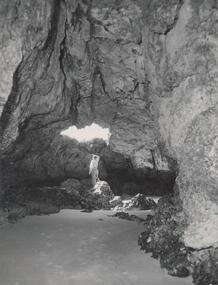 Phillip Island and District Historical Society Inc.
Photograph, Bryant West
... Phillip Island and District Historical Society Inc. phillip-island-and-the-bass-coast One of a collection of over 400 photographs in an album commenced in 1960 and presented to the Phillip Island & Westernport Historical Society by the Shire of Phillip Island local history photography photographs coastline caves phillip island forrest caves phillip island john jenner bryant west Photograph inside Forrest Caves South Coast Phillip Island. ...One of a collection of over 400 photographs in an album commenced in 1960 and presented to the Phillip Island & Westernport Historical Society by the Shire of Phillip IslandPhotograph inside Forrest Caves South Coast Phillip Island. Man inside looking out. local history, photography, photographs, coastline, caves, phillip island, forrest caves phillip island, john jenner, bryant west -
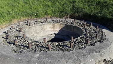 Flagstaff Hill Maritime Museum and Village
Gun Emplacement, 1890's
... coastline. The Warrnambool Garrison has been added to the Victorian Heritage Register H1250 “for its intact battery and guns, a strong reminder of Victoria’s wealth and determination to protect itself from the perceived threat of invasion in the 1880’s.” The City of Warrnambool is one of several custodians of a collection of artillery pieces of heritage significance at a state, national and international level. These pieces are directly related to the defence of south-west Victoria in the 19th century. The care and preservation come under the Heritage Act 1995. flagstaff hill warrnambool shipwrecked coast ...The Warrnambool Battery on Flagstaff Hill has embankments for 3 guns. Those on the left and right still have cannon in place but in the centre is an empty embankment, apart from this concrete ring with metal threaded studs. In 1898 a 5 inch breech loading gun (BL) was installed here. The gun had a hydro-pneumatic disappearing carriage (hence the sign on the concrete wall "5" BL HP").. This type of gun was faster to load and fire that the 80 pound RML’s installed on either side of it. Its arrival spelt the end of the 80 pound RML guns’ useful life, although they continued to be used for practice sessions. The 5 inch BL was the main defensive weapon of the Warrnambool Battery until the Battery was downgraded in importance. It was removed in 1904 and recalled to Melbourne in 1910. The gun emplacement ring is all that remains of the mounting for a 5 inch Armstrong rifled breech loading gun. HISTOR of the WARRNAMBOOL GUNS & CANNON In the years following the Crimean War (1854-1857J) there was a great concern in the Colony that Imperial Russia would attempt an invasion. Coastal defences in the colony of Victoria were greatly strengthened by the Government as a result. Warrnambool was originally protected by cannons at Cannon Hill, approximately 1 kilometer west of the Flagstaff Hill Fortifications. The cannons included two 1866 guns, both 80 Pound Rifled Muzzle Loaders (RML) purchased by Victoria’s Colonial Government. They were part of a shipment of 26 such guns sent from England in December 1866. They are registered as No. 23 (80cwt-2qr-0lbs) - Gun 1, and No.13 (81cwt-1qr-12lbs) - Gun 2. They were cast at the Royal Gun Factory, Woolwich Arsenal, in 1866 and have a 6.3 inch bore. Both barrels carry the Royal Cypher of Queen Victoria, Insignia of the Royal Engineers, within the Garter and Motto surmounted by the Crown, with the Royal Cypher of Queen Victoria within the Garter (letters in centre “VR”, motto “HONI SOIT QUI MAL Y PENSE”, "Shame be to him who thinks evil of it."). The guns were originally supplied with wooden carriages. (The Royal Arsenal at Woolwich, England, was established eleven years after the Restoration of King Charles II. It was the principal supplier of armaments to the British and Empire Governments. At the height of its operations during World War One the factory covered 1300 acres and employed very nearly 80,000 workers. Woolwich was the Headquarters of the Royal Artillery since the raising of that Regiment in 1716. The Arsenal was closed in the late 1960’s.) These two 80pdr cannons were transferred to the Warrnambool Garrison Artillery Battery Fortifications erected at Flagstaff Hill in 1887 as part of Victoria’s Coastal Defences. The original wooden carriages were subsequently replaced with the present iron garrison carriages in 1888. They are a “C” pivot. The ‘racers’ or curved track set into the floor of the gun emplacement (which enabled the guns to be traversed more quickly) are as specified for guns up to 10 inch, being of wrought iron 2.78 inches wide. A temporary third gun, now no longer on Flagstaff Hill’s site, was the 5 inch Rifled Breech Loading (BL) Armstrong gun mounted on an Elswick hydro pneumatic disappearing carriage and installed in this very concrete base or pad. The State of Victoria took over the ownership of the guns at the time of Australian Federation in 1901. In about 1901/1902 the Garrison Battery was converted to the Warrnambool Battery of the Australian Field Artillery (No 4 Field Battery). It was equipped with 4.7 inch naval guns mounted on field carriages. They were now a mobile unit but continued to use the Warrnambool Garrison area at Flagstaff Hill for practice. When the Fortifications were declared obsolete the two 80 Pounder RML were relocated to Cannon Hill in 1910. On the outbreak of World War One the 4.7 inch guns were recalled to Melbourne, and the Battery was disbanded. Most of the personnel probably re-enlisted in the local 4th Australian Light Horse Regiment. The two 80 Pounder RML were moved back to the Fortifications in 1973. They were both fully restored by Army First Year Apprentices at the Ordinance Factory in Bendigo in time for the centenary year of the fortifications in 1987. The guns are capable of firing 80 pound (32.3kg) armour piercing exploding shells 3.65kms out to sea. They were originally manned by volunteers before a paid Garrison was established. Now the Guns are again fired by volunteers on Special Event days. Since restoration the Gun Number 1 had been fired on a regular basis but Gun Number 2 hadn’t been fired since the mid 1990’s. In April 2015 Gun Number 2 was serviced in preparation for the firing of both cannons on the ANZAC Centenary commemorations on April 25th 2015. Other guns from the original Cannon Hill location were obsolete by the time the 1887 Warrnambool Garrison Artillery Battery was built. These guns are (1) a 32 Pounder Muzzle Loading Smooth Bore (SB) cast in 1813 at the famous Carron Foundry, number 80837 and now located in the Warrnambool Botanic Gardens. It is now mounted on a replica carriage due to the original carriage being in a fragile condition (the original carriage stored under cover at Flagstaff Hill). (2) a 68 Pounder Muzzle Loading Smooth Bore cast in 1861 at the equally august Low Moor Foundry, number 10310 and now located on the lawn area at the entrance to Flagstaff Hill Maritime Village. It is still mounted on its original wooden garrison carriage. Its wooden slide compressor mechanism is fragile and now kept in Flagstaff Hill’s storage. There are only seven 32 Pounder SB made by Carron and fifteen 68 Pounder SB made at Low Moor known to exist in the State of Victoria [references; Flagstaff Hill Maritime Village interpretation boards, information sheets and other documents; South Western Victoria Guns and Cannon report, May 2008, ref W/F/08] The Gun embankment is contained within the heritage listed Lady Bay Lighthouse Comples, on the Victorian Heritage Register VHR H1520. The gun emplacement base is evidence of the last defences installed on this stretch of coastline. The Warrnambool Garrison has been added to the Victorian Heritage Register H1250 “for its intact battery and guns, a strong reminder of Victoria’s wealth and determination to protect itself from the perceived threat of invasion in the 1880’s.” The City of Warrnambool is one of several custodians of a collection of artillery pieces of heritage significance at a state, national and international level. These pieces are directly related to the defence of south-west Victoria in the 19th century. The care and preservation come under the Heritage Act 1995. Gun emplacement; the remains of the mounting platform of a temporary third gun installed in 1898 in the centre of the battery. This consists of a circular concrete well or sump surrounded by two rings of mounting bolts, the inner of 10 and the outer of 20. The base once held a 5 inch Armstrong rifled breech loading gun with hydro-pneumatic disappearing. In the centre of the ring on the ground is a keyhole shaped space. The gun was removed in 1904. flagstaff hill, warrnambool, shipwrecked coast, flagstaff hill maritime museum, maritime museum, shipwreck coast, flagstaff hill maritime village, great ocean road, colonial defences, victoria’s coastal defences, warrnambool fortification, warrnambool garrison battery, warrnambool volunteer corps, ordinance, armaments, cannon hill fortifications, flagstaff hill fortifications, 4th australian light horse regiment, garrison gun, 5 inch breech loading gun, emplacement for hydro-pneumatic disappearing carriage, gun emplacement -
 Flagstaff Hill Maritime Museum and Village
Photograph - Vessel S. S. Casino in Lady Bay Warrnambool, 1920's - 1930's
... coast of Victoria, including Warrnambool. The carts would take their loads into the township for distribution. The Breakwater was built (using 32 ton blocks of concrete) between 1874 and 1890 to provide ships with greater protection from the Southern Ocean. The Lifeboat and Rocket House - The coastline of South...coast of Victoria, including Warrnambool. The carts would take their loads into the township for distribution. The Breakwater was built (using 32 ton blocks of concrete) between 1874 and 1890 to provide ships with greater protection from the Southern Ocean. The Lifeboat and Rocket House - The coastline of South ...This photograph was one of ten photographs donated to Flagstaff Hill Maritime Museum and Village by Fred Trewartha. Frederick John Fox Trewartha (Fred) was a well-known Warrnambool businessman. He was born in Beeac near Geelong in 1920 and came to Warrnambool with his family as a very young child. He was apprenticed to his father John, as a saddler and later opened his own shop on Raglan Parade. He then moved into working with tarpaulins and canvases for the trucking industry. Fred was keenly interested in photography (and was a member of the Warrnambool Cine Club), yachting and boat building. He kept his yacht moored at Port Fairy for many years and participated in sailing events locally and interstate. He also built boats with his sons. He had the opportunity to meet many older sailors and it's thought this photo (and others in the set) may have been given to him by one of these men. Fred Trewartha died in 2016 in Warrnambool. Warrnambool by the 1920's and 1930's had become a popular holiday destination with visitors arriving by steamer and train. It was during these decades that a "Surf Bathers Association" began in Warrnambool in response to the growing popularity of local sea bathing. They worked with the local council to develop a "Beach Improvement Fund" and a comprehensive plan of "Beach Improvement" which included erecting and maintaining beach boxes, building a kiosk, improving paths and roads to the beach, planting marram grass on the sand dunes, building new enclosures for vehicles and horses and generally making the beach more attractive for visitors and townspeople. The 1930's was also an era when free "Herald" Learn-to-Swim classes were being held throughout Victoria. In 1931 it was reported in "The Age" newspaper that "over the past week in Warrnambool, 250 pupils had passed through the hands of the local life saving club swimming instructors". The Port of Warrnambool - In the early years the Port of Warrnambool was a busy port. Steamships and sailing ships were frequent visitors to the port. Steam navigation companies were plentiful, carrying passengers and freighting cargo such as coal, timber, food, livestock, furniture, hardware and haberdashery between Melbourne and the ports along the southwest coast of Victoria, including Warrnambool. The carts would take their loads into the township for distribution. The Breakwater was built (using 32 ton blocks of concrete) between 1874 and 1890 to provide ships with greater protection from the Southern Ocean. The Lifeboat and Rocket House - The coastline of South West Victoria has had over 600 shipwrecks and many lost lives; even in Warrnambool’s Lady Bay there were around 16 known shipwrecks between 1850 and 1905, with eight lives lost. In 1859 the first Government-built lifeboat arrived at Warrnambool Harbour and a shed was soon built to house it, followed in 1864 by a rocket house to safely store the Rocket Rescue equipment. In 1878 the buildings were moved to the Breakwater area, and in 1910 the new Lifeboat Warrnambool arrived with its ‘self-righting’ design. For almost one hundred years the lifeboat and rocket crews, mostly local volunteers, trained regularly to maintain and improve their skills, summoned when needed by alarms, gunshots, ringing bells and foghorns. Some became local heroes but all served an important role. By the end of the 1950s the lifeboat and rescue equipment had become obsolete. The S.S. Casino was a passenger and freight steamer built in Dundee, Scotland, in 1882 for the Newcastle and Hunter River Steam Navigation Company of N.S.W. She weighed 425 tons gross with a length of 160.4 feet, beam of 24.1 feet and a depth of 10.2 feet. She had saloon accommodation for 35 people, a fore cabin for 25 more people, and she carried 300 tons of cargo. While on her delivery journey on May 30th 1882, the S.S. Casino called in at the Port of Warrnambool for coal, narrowly escaping going ashore in gale force winds due to the quick action of the pilot. At that time, still at anchor, she impressed the directors of the Belfast and Koroit Steam Navigation Company so much that they bought her immediately; she was ideal for trade along the West Coast of Victoria. (The Belfast and Koroit Steam Navigation Company was first managed by Messers. Saltau and Osburne and after the passing of Mr. Osburne, by produce merchants Messers H. Sautau and Sons, who had a hay and corn store and shipping agency on the corner of Liebig and Koroit Streets in Warrnambool. ) The S.S. Casino became “the most famous steamer to operate in Victorian waters along the West Coast” by author Jack Loney. Captain Boyd was her first Master, followed by Captain Chapman, who stayed with her from 1890 until 1924. Captain W. Robertson followed for a short term, and then Captain Middleton then took command from 1925 - 1932. An article published on Monday 11th June 1932 in The Sun News Pictorial (Melbourne) giving a detailed history of S. S. Casino said "owned by Port Fairy interests, she was an integral part of the town's development ... for a long time, her arrival in Port Fairy was an event, the townspeople going down to the wharf to see her come in". It also said "Except when the weather was bad, the Casino hugged the coast on her trips and passengers obtained wonderful views of the sandstone terraces and caves. A little time ago every member of her regular crew except one, was a Scotsman." The S.S. Casino had several mishaps during her life. One was on 3rd January 1898 when she collided with the S.S. Flinders in Apollo Bay with minor damage. Another was on 24th October 1924 when she grounded on a reef at Point Hawdon near Grey River and most of her cargo (of Christmas goods) had to be dumped into the sea. Then in February 1929 she was ‘holed’ when she struck a submerged object as she entered Lady Bay, Warrnambool. In the years following the turn of the century, the S.S. Casino remained the only regular trader with normal passenger accommodation along the West Coast. From 1882 she had made at least 2,500 voyages on the one run. On the morning of 10th July 1932, after attempting to berth at Apollo Bay jetty in heavy seas, Captain Middleton decided to take her out into the bay and wait until the seas abated. It was not realised that the anchor used to steady her as she manoeuvred to her berth had pierced her hull. She put about and headed for the beach but sank. Captain Middleton and nine others lost their lives; nine people were rescued including the two female passengers. Captain Middleton had been in charge of the S.S. Casino for seven years. He was the first ship’s Master to lose his life in a shipwreck in the West Coast trade. In June 1932, the directors of the Belfast and Koroit Steam Navigation Company had proposed to celebrate the completion of fifty years of trading by the steamer Casino in August, but tragically the Casino was wrecked only one month later (and "was only one month off completing its fifty years of valuable service between Melbourne and Portland.") Flagstaff Hill’s collection has a photograph of a portrait of Captain Chapman, a ship model of the S.S. Casino that shows both forms of power under which she sailed, steam and sail. The ship is painted green and flies three flags. The inscription across the case of the ship model, incorrectly dated, tells the sad story of the wreck of the ship and the loss of lives on July 10th 1932 at Apollo Bay. A print in the Collection shows S.S. Casino underway in the heavy sea off Point Lonsdale, another two photographs show her at the Port of Warrnambool, leaving from the Breakwater in Lady Bay and another identifies the S.S. Casino as a ship from the Belfast and Koroit Steam Navigation Company. (Belfast is the original name for the township of Port Fairy).This photograph is significant because of its association with the coastal trader S.S. Casino and its significance to trade along Victoria's West Coast in the late 19th and early 20th centuries. The wreck of the S.S. Casino is considered an important part of Victorian and Australian cultural heritage and as such has been declared and protected as an Historic Shipwreck under State and Commonwealth Law in the Commonwealth Historic Shipwrecks Act (1976). It is also significant as it shows the early years of tourism in Warrnambool and the important role the beach played in the lives of residents and visitors.A black and white photograph (with colour tinting) showing Lady Bay in Warrnambool with the Breakwater in the background. The S. S. Casino is moored at the Breakwater and the lifeboat shed and a coal train can be seen on the Breakwater. Six swimmers are standing in the water. On the back of the photograph are the donor's name and telephone number (written in black biro) and the name of the S. S. Casino and its tonnage written in blue ink. A blurred number has been stamped on plus a "M' written in pencil.Donor's name, address and phone number / "S. S. Casino" / "500 TONS" / "REG" "- - - 09 " (blurred numbers) / "M"warrnambool, great ocean road, shipwreck coast, lady bay, breakwater, fred trewartha, frederick john fox trewartha, surf bathers association, sea bathing, swimming, warrnambool beach, beach improvement fund, port of warrnambool, steamships, lifeboat house, rocket house, lifeboat crew, s. s. casino, belfast and koroit steam navigation company, saltau and osburne, captain middleton, apollo bay, apollo bay shipwreck -
 Flagstaff Hill Maritime Museum and Village
Photograph - Coastal Scene, Joseph Jordan Photographic Studio, Lady Bay and Breakwater, Warrnambool, circa 1907
... coast of Victoria, including Warrnambool. The carts would take their loads into the township for distribution. The Breakwater was built (using 32 ton blocks of concrete) between 1874 and 1890 to provide ships with greater protection from the Southern Ocean. The Lifeboat and Rocket House - The coastline of South...coast of Victoria, including Warrnambool. The carts would take their loads into the township for distribution. The Breakwater was built (using 32 ton blocks of concrete) between 1874 and 1890 to provide ships with greater protection from the Southern Ocean. The Lifeboat and Rocket House - The coastline of South ...The Port of Warrnambool - In the early years the Port of Warrnambool was a busy port. Steamships and sailing ships were frequent visitors to the port. Steam navigation companies were plentiful, carrying passengers and freighting cargo such as coal, timber, food, livestock, furniture, hardware and haberdashery between Melbourne and the ports along the southwest coast of Victoria, including Warrnambool. The carts would take their loads into the township for distribution. The Breakwater was built (using 32 ton blocks of concrete) between 1874 and 1890 to provide ships with greater protection from the Southern Ocean. The Lifeboat and Rocket House - The coastline of South West Victoria has had over 600 shipwrecks and many lost lives; even in Warrnambool’s Lady Bay there were around 16 known shipwrecks between 1850 and 1905, with eight lives lost. In 1859 the first Government-built lifeboat arrived at Warrnambool Harbour and a shed was soon built to house it, followed in 1864 by a rocket house to safely store the Rocket Rescue equipment. In 1878 the buildings were moved to the Breakwater area, and in 1910 the new Lifeboat Warrnambool arrived with its ‘self-righting’ design. For almost one hundred years the lifeboat and rocket crews, mostly local volunteers, trained regularly to maintain and improve their skills, summoned when needed by alarms, gunshots, ringing bells and foghorns. Some became local heroes but all served an important role. By the end of the 1950s the lifeboat and rescue equipment had become obsolete. Joseph Jordan - Joseph Jordan was born in 1841 in Leicester England. When he was 16 he joined the 7th Queen's Own Hussars and was sent to India at the outbreak of the mutiny. He took part in the relief of Lucknow and remained in India for eleven years. It was during this time, he became interested in photography. He was posted to New Zealand and later came to Victoria, becoming a sergeant major of the Mounted Rifles. In the mid 1880s he came to the Western district where he was responsible for establishing units of the Mounted Rifles in various country towns such as Dunkeld, Mortlake, Panmure, Bushfield, Koroit etc. He resigned from the army in 1889 and set up a professional photography studio in Liebig Street, Warrnambool. He became very well known in the Western District for family photographs, official photographs of local councillors and groups as well as views of local scenery. In 1891 he photographed the wrecked barque "Fiji" at "Wrecks Beach" near Princetown. His business was taken over by his son Arthur around 1917. Joseph was a keen rifle shot and in 1924 he donated the "Jordan Shield" as a prize to the Victorian Rifle Association. He was made a "Life Honorary Member" of the Warrnambool Returned Soldiers League and in 1933 he was recognised as being the oldest living soldier in Victoria. Joseph died in 1935 aged 95.This photograph is significant for its association with the Port of Warrnambool and the Warrnambool Breakwater as it shows a point in time when shipping activities were an important part of Warrnambool's commerce and social development. It is also a record of the Warrnambool Lifeboat and Rocket house which was important in aiding ordinary citizens, harbour employees and the volunteer boat and rescue crew in saving the lives of sailors and passengers due to the high number of shipwrecks that occurred along the coastline. Joseph Jordan is a significant figure in Warrnambool history as he helped to establish early units of the Mounted Rifles (G Company) in local towns during the late 1880's and later, photographed local scenes, groups and citizens of early Warrnambool. Sepia photograph showing the beach and the Breakwater in Lady Bay Warrnambool, two ships (a steamship and a barque), a small sailboat, and the Lifeboat and Rocket House plus two smaller sheds.Front of photo - BREAKWATER, WARRNAMBOOL, VICTORIA Back of photo - "From: P Gregory / 365 Beach Road / BLACK ROCK 3193"flagstaff hill, flagstaff hill maritime museum, warrnambool, warrnambool harbour, port of warrnambool, tramway jetty, breakwater, lifeboat and rocket shed, steamship, barque, photograph of lady bay, rocket house, shipping, joseph jordan, lady bay, views of warrnambool, jordan photography -
 Flagstaff Hill Maritime Museum and Village
Book, The Logbooks of The Lady Nelson, 1915
... South Australia. A report by Ecclestone in 2012, ‘The Early Charting of Victoria’s Coastline’, mentions that Grant charted and named Capes Banks and Northumberland, and sighted inland hills that he named Mt Gambier and Mt Schanck, the latter after the designer of his ship. Grant then reached the south-western shores of what is now Victoria on 3-4 December 1800, and from Cape Bridgewater he examined the coast...South Australia. A report by Ecclestone in 2012, ‘The Early Charting of Victoria’s Coastline’, mentions that Grant charted and named Capes Banks and Northumberland, and sighted inland hills that he named Mt Gambier and Mt Schanck, the latter after the designer of his ship. Grant then reached the south-western shores of what is now Victoria on 3-4 December 1800, and from Cape Bridgewater he examined the coast ...This hardcover book, The logbooks of the 'Lady Nelson' : with the journal of her first commander, Lieutenant James Grant, R.N., by Ida Lee (Mrs Charles Bruce Marriott) was published over 100 years after the Lady Nelson arrived in Australia to navigate and survey this ‘new colony’. Included in the book are sixteen charts and illustrations from the originals in the Admiralty Library, showing the surveyed land and water. The transcribed Contents, below, summarise the trips of the Lady Nelson during this time. Book’s Content PLUS text of the Chart of ‘Part of Bass Strait’ - Chapter 1: The Lady Nelson built with centreboards. Her voyage to Sydney under James Grant. The first ship to pass through Bass Strait. - Chapter 2: Returns to explore the Strait. Her visits to Jervis Bay and to Western Port in 1801 - Chapter 3: Colonel Paterson and Lieutenant Grant survey Hunter River - Chapter 4: Murray appointed commander of the Lady Nelson. His voyage to Norfolk Island. - Chapter 5: Murray’s exploration of Bass Strait. - Chapter 6: Discovery of Port Phillip. - Chapter 7: The Lady Nelson in company with HMS Investigator examines the North-Eastern shores of Australia. - Chapter 8: The French ships in Bass Strait. The founding of Hobart. - Chapter 9: Symons succeeds Curtoys as commander of the Lady Nelson. His voyages to Tasmania, Port Phillip and New Zealand. - Chapter 10: The Lady Nelson in Tasmania. The founding of Port Dalrymple. - Chapter 11: The Estramina is brought to Sydney. The Lady Nelson visits Norfolk Island and Port Dalrymple. - Chapter 12: Tippahee and his four sons are conveyed to New Zealand in the Lady Nelson. - Chapter 13: The Lady Nelson accompanies HMS Tamar to Melville Island. - Chapter 14: The loss of the Lady Nelson Text included with the ‘Chart of Bass Strait’ … “Part of Bass Strait, including the discoveries made by Acting Lieut. J. Murray, commander of His Majesty’s armed surveying vessel Lady Nelson, between November 1801 and March 1802. By command of His Excellency Governor King.” “This chart, which bears Murray’s autograph, shows his explorations of Western Port, Port Phillip and King Island. It should be noted that Flinders Island is named Grand Capuchin. This is one of the charts referred to as "unfortunately missing” in the Historical Records of N.S. Wales, vol. iv. P. 764” The story of the Lady Nelson In 1798 the British Admiralty ordered a cutter of 60 tons to be built along the design of the armed cutter Trial that was developed by Captain John Schanck, with three sliding keels or centreboards that could be individually raised and lowered, for use on the River Thames. The new cutter was to be named Lady Nelson. Philip Gidley King, prior to taking up his appointment as third Governor of the colony of New South Wales, was in England at the time of the Lady Nelson’s fit-out and was aware of the need for such a ship for survey work in the colony in New South Wales. He convinced Captain Schanck, the Commissioner of Transport in England, to construct and rig the Lady Nelson as a brig rather than a cutter, keeping the feature of the three sliding keels, which would be very useful for mapping in shallow waters. The new Lady Nelson was launched at Deptford, England on the River Thames in November 1798, with the official commission to discover and survey the unknown parts of the coast of New Holland (Australia) and establish British sovereignty over the continent. The Lady Nelson sailed from Portsmouth, England on March 1800 under the command of Lieutenant James Grant. She carried an armament of two original and four extra brass carronade carriage guns and set sail as part of a convoy heading to Port Jackson, in New South Wales, New Holland. After a while she continued to sail on her own. Her journey was troubled with problems at times; damaged and broken keels, troublesome crew and leaking topsides between the waterline and the deck due to poor seals. She arrived at the Cape of Good Hope in July and waited for the winter to pass to avoid the strong winds of the ‘Roaring Forties’. While at the Cape, Grant received a despatch to travel to Port Jackson via the newly discovered Bass Strait, rather than the usual route via the tip of Van Diemen’s Land (Tasmania). This also gave him the opportunity to survey the strait on the way. He departed the Cape in October and in December he made his first sighting of New Holland near Mount Gambier in what is now South Australia. A report by Ecclestone in 2012, ‘The Early Charting of Victoria’s Coastline’, mentions that Grant charted and named Capes Banks and Northumberland, and sighted inland hills that he named Mt Gambier and Mt Schanck, the latter after the designer of his ship. Grant then reached the south-western shores of what is now Victoria on 3-4 December 1800, and from Cape Bridgewater he examined the coast eastward to Cape Patton. Although he had not continuously sighted the coast in the vicinity of Port Fairy and Warrnambool, the western part of Victoria became known as Grant’s Land. The Lady Nelson continued eastward and passed through Bass Strait, becoming the first vessel to reach the east coast of New Holland from the west, and arrived at her destination of Port Jackson later in December 1800. Grant, in the Lady Nelson, then left Port Jackson and began survey work. He discovered Port Phillip on Victoria’s coast and explored King Island, he helped establish the first European settlement in Tasmania on the Derwent River, and Port Dalrymple, Newcastle and Port Macquarie. He made several trips from Norfolk Island to Hobart Town. Governor Macquarie sailed on with him to Van Diemen’s Land for a tour of inspection in 1811. Grant helped establish the first settlement on Melville Island in Northern Australia. The Lady Nelson was used to transport cargo, civilians and convicts and to source pigs from Timor. In February 1825 the Lady Nelson sailed again for Timor and never returned. One report said that “Every soul on board, we regret to state, was cruelly massacred, and the hull of the vessel was seen some time after with the name painted on her stern.” The hull was sighted on the island of Babar, which is almost 200 kilometres east of Timor. This particular copy of the book ... This item is from the ‘Pattison Collection’, a collection of books and records that was originally owned by the Warrnambool Mechanics’ Institute, which was founded in Warrnambool in 1853. By 1886 the Warrnambool Mechanics’ Institute (WMI) had grown to have a Library, Museum and Fine Arts Gallery, with a collection of “… choice productions of art, and valuable specimens in almost every branch and many wonderful national curiosities are now to be seen there, including historic relics of the town and district.” It later included a School of Design. Although it was very well patronised, the lack of financial support led the WMI in 1911 to ask the City Council to take it over. In 1935 Ralph Pattison was appointed as City Librarian to establish and organise the Warrnambool Library as it was then called. When the WMI building was pulled down in 1963 a new civic building was erected on the site and the new Warrnambool Library, on behalf of the City Council, took over all the holdings of the WMI. At this time some of the items were separated and identified as the ‘Pattison Collection’, named after Ralph Pattison. Eventually the components of the WMI were distributed from the Warrnambool Library to various places, including the Art Gallery, Historical Society and Flagstaff Hill. Later some were even distributed to other regional branches of Corangamite Regional Library and passed to and fro. It is difficult now to trace just where all of the items have ended up. The books at Flagstaff Hill Maritime Village generally display stamps and markings from Pattison as well as a variety of other institutions including the Mechanics’ Institute itself. RALPH ERIC PATTISON Ralph Eric Pattison was born in Rockhampton, Queensland, in 1891. He married Maude Swan from Warrnambool in 1920 and they set up home in Warrnambool. In 1935 Pattison accepted a position as City Librarian for the Warrnambool City Council. His huge challenge was to make a functional library within two rooms of the Mechanics’ Institute. He tirelessly cleaned, cleared and sorted a disarrayed collection of old books, jars of preserved specimens and other items reserved for exhibition in the city’s museum. He developed and updated the library with a wide variety of books for all tastes, including reference books for students; a difficult task to fulfil during the years following the Depression. He converted all of the lower area of the building into a library, reference room and reading room for members and the public. The books were sorted and stored using a cataloguing and card index system that he had developed himself. He also prepared the upper floor of the building and established the Art Gallery and later the Museum, a place to exhibit the many old relics that had been stored for years for this purpose. One of the treasures he found was a beautiful ancient clock, which he repaired, restored and enjoyed using in his office during the years of his service there. Ralph Pattison was described as “a meticulous gentleman whose punctuality, floorless courtesy and distinctive neat dress were hallmarks of his character, and ‘his’ clock controlled his daily routine, and his opening and closing of the library’s large heavy doors to the minute.” Pattison took leave during 1942 to 1945 to serve in the Royal Australian Navy, Volunteer Reserve as Lieutenant. A few years later he converted one of the Museum’s rooms into a Children’s Library, stocking it with suitable books for the younger generation. This was an instant success. In the 1950’s he had the honour of being appointed to the Victorian Library Board and received more inspiration from the monthly conferences in Melbourne. He was sadly retired in 1959 after over 23 years of service, due to the fact that he had gone over the working age of council officers. However he continued to take a very keen interest in the continual development of the Library until his death in 1969 This book about the logbooks of the Lady Nelson is locally significant for its association with the brig Lady Nelson, in which Lt. James Grant made the first documented European discovery of the area later known as Warrnambool in December 1800. This book is also nationally significant for its association with Grant in the Lady Nelson being the first to sail from west to east through Bass Strait, opening up a shorter, faster route to the colony of Port Jackson rather than going all the way south around Van Diemen’s Land. The book is nationally significant for its contents of the logbooks of the journeys of the Lady Nelson under various commanders and the copies of the charts created from the surveyed information and the new land of Australia was discovered. This book is also significant for its association with the full-size non-sailing replica of the Lady Nelson from Mount Gambier’s visitor centre, which was restored by Flagstaff Hill’s Master Boat Builder in Warrnambool in 2012, and with a ship mode of the Lady Nelson in our Collection The Pattison Collection, along with other items at Flagstaff Hill Maritime Village, was originally part of the Warrnambool Mechanics' Institute’s collection. The Warrnambool Mechanics’ Institute Collection is primarily significant in its totality, rather than for the individual objects it contains. Its contents are highly representative of the development of Mechanics' Institute libraries across Australia, particularly Victoria. A diversity of publications and themes has been amassed, and these provide clues to our understanding of the nature of and changes in the reading habits of Victorians from the 1850s to the middle of the 20th century. The collection also highlights the Warrnambool community’s commitment to the Mechanics’ Institute, reading, literacy and learning in the regions, and proves that access to knowledge was not impeded by distance. These items help to provide a more complete picture of our community’s ideals and aspirations. The Warrnambool Mechanics Institute book collection has historical and social significance for its strong association with the Mechanics Institute movement and the important role it played in the intellectual, cultural and social development of people throughout the latter part of the nineteenth century and the early twentieth century. The collection of books is a rare example of an early lending library and its significance is enhanced by the survival of an original collection of many volumes. The Warrnambool Mechanics' Institute’s publication collection is of both local and state significance. The Logbooks of The Lady Nelson Author: Ida Lee ( Mrs Charles Bruce Marriott) Publisher: Grafton & Co Date: 1915Label on spine with typed text RA 910.994 LEE Inside front cover has a sticker that reads Warrnambool Mechanics Institute and Free Library shipwrecked-coast, flagstaff-hill, warrnambool, flagstaff-hill-maritime-museum, maritime-museum, shipwreck-coast, flagstaff-hill-maritime-village, shipwrecked-artefact, book, warrnambool library, warrnambool mechanics’ institute, warrnambool city librarian, mechanics’ institute library, victorian library board, warrnambool books and records, warrnambool children’s library, great ocean road, the logbooks of the lady nelson, ida lee, mrs charles bruce marriott, captain john schanck, sliding keels or centreboards, lady nelson, british brig hms lady nelson, lieutennant james grant, bass strait discovery, surveying king island and port phillip bay, philip gidley king, survey map -
 Glenelg Shire Council Cultural Collection
Photograph - Photograph - aerial view of Portland coast, c. 1954
... Glenelg Shire Council Cultural Collection History House Cliff Street Portland great-ocean-road aerial photography central Portland Portland Harbour south west coastline Front: '820 -8' - handwritten, white, lower border 'RUN 5' 'PORTLAND', printed, white, lower border Black and white aerial photograph of coastline around Portland. Black border, scale all sides, 5 rows of 3 't' at regular intervals. Ocean, land with lakes Photograph Photograph - aerial view of Portland coast ...Black and white aerial photograph of coastline around Portland. Black border, scale all sides, 5 rows of 3 't' at regular intervals. Ocean, land with lakesFront: '820 -8' - handwritten, white, lower border 'RUN 5' 'PORTLAND', printed, white, lower borderaerial photography, central portland, portland harbour, south west coastline