Showing 571 items matching "commercial centre"
-
 RMIT GSBL Justice Smith Collection
Report, Monash University, Advanced civil litigation : papers from a series of lectures sponsored by the Centre of Commercial Law and Applied Legal Research Faculty of Law, Monash University : held in Melbourne March 1985, [1985]
... Advanced civil litigation : papers from a series of lectures sponsored by the Centre of Commercial Law and Applied Legal Research Faculty of Law, Monash University : held in Melbourne March 1985...RMIT GSBL Justice Smith Collection Building 13 379-405 Russell Street Melbourne melbourne civil procedure -- victoria -- congresses pre-trial procedure -- victoria -- congresses March 1985 Current legal developments series Advanced civil litigation : papers from a series of lectures sponsored by the Centre of Commercial Law and Applied Legal Research Faculty of Law, Monash University : held in Melbourne March 1985 Report Monash University ...March 1985 Current legal developments seriescivil procedure -- victoria -- congresses, pre-trial procedure -- victoria -- congresses -
Moorabbin Air Museum
Book - Aircraft engines, Engines And Systems For Commercial Pilots Flight Training Centre (Aust) Pty Ltd
... Engines And Systems For Commercial Pilots Flight Training Centre (Aust) Pty Ltd...Moorabbin Air Museum Moorabbin Airport 12 First Street Moorabbin melbourne Aircraft Engines Engine & systems Overview of aircraft, piston engines, engine & aircraft support systems & operating procedures for commercial pilots, circa 1972 Engines And Systems For Commercial Pilots Flight Training Centre (Aust) Pty Ltd Book Aircraft engines ...Overview of aircraft, piston engines, engine & aircraft support systems & operating procedures for commercial pilots, circa 1972non-fictionOverview of aircraft, piston engines, engine & aircraft support systems & operating procedures for commercial pilots, circa 1972engine & systems -
Moorabbin Air Museum
Book - Aviation training, Engines And Systems For Commercial Pilots Flight Training Centre (Aust) Pty Ltd
... Engines And Systems For Commercial Pilots Flight Training Centre (Aust) Pty Ltd...Moorabbin Air Museum Moorabbin Airport 12 First Street Moorabbin melbourne Aviation training The airplane Piston engine principles Engine support systems Airplane support systems Operating procedures & faults Overview of engines & systems for trainee commercial pilots, circa 1974 Engines And Systems For Commercial Pilots Flight Training Centre (Aust) Pty Ltd Book Aviation training ...Overview of engines & systems for trainee commercial pilots, circa 1974non-fictionOverview of engines & systems for trainee commercial pilots, circa 1974the airplane, piston engine principles, engine support systems, airplane support systems, operating procedures & faults -
 Ballarat Heritage Services
Digital photographs, L.J. Gervasoni, Warrnambool Koroit Street, c2011
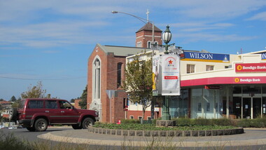
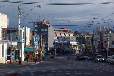
... ...commercial centre...Ballarat Heritage Services PO Box 2209 Bakery Hill Post Office goldfields warrnambool landscape koroit street shops commercial centre Colour photograph of a roundabout at Koroit Street, Warrnambool. ...Colour photograph of a roundabout at Koroit Street, Warrnambool.warrnambool, landscape, koroit street, shops, commercial centre -
 Sunbury Family History and Heritage Society Inc.
Photograph, Rosa McCall, 2000
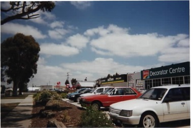
... A non-digital coloured photograph of a commercial centre with cars parked in the designated area in front of the businesses. ...Horne Street Neill Street Mitchells Lane Pasley Street Sunbury Commercial Development A non-digital coloured photograph of a commercial centre with cars parked in the designated area in front of the businesses. ...The commercial development was built along Horne Street between Mitchells Lane and Neill Street in 2000 on land that had been open space. This development was one of many that reflected the growth of Sunbury from a country town to an outer suburb of Melbourne.A non-digital coloured photograph of a commercial centre with cars parked in the designated area in front of the businesses. Along the roadside and bordering the footpath are large gum trees. horne street, neill street, mitchells lane, pasley street, sunbury, commercial development -
Lakes Entrance Historical Society
Book, Bairnsdale Shire Council Centenary 1868, 1968
... A short history of the Shire of Bairnsdale Victoria from beginnings as a road district to the separation of the commercial centre as the Towns of Bairnsdale illustrated with photographs. ...Lakes Entrance Historical Society 4 Marine Parade Lakes Entrance gippsland Township Photography A short history of the Shire of Bairnsdale Victoria from beginnings as a road district to the separation of the commercial centre as the Towns of Bairnsdale illustrated with photographs. ...A short history of the Shire of Bairnsdale Victoria from beginnings as a road district to the separation of the commercial centre as the Towns of Bairnsdale illustrated with photographs. A list of Shire Presidents and officers is included.township, photography -
 Greensborough Historical Society
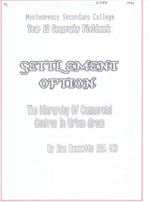
Folder, Ian Bennetts, Settlement option: the hierarchy of commercial centres in urban areas, by Ian Bennetts, 1990_
... Year 12 Geography Fieldwork assignment aims: (1) to establish if there is a hierarchy of commercial centres in the Greensborough area, and (2) to establish the hinterlands of selected commercial centres in the Greensborough area. ...Greensborough Historical Society 34A Glenauburn Road Lower Plenty Lower Plenty melbourne Year 12 Geography Fieldwork assignment aims: (1) to establish if there is a hierarchy of commercial centres in the Greensborough area, and (2) to establish the hinterlands of selected commercial centres in the Greensborough area. ...Year 12 Geography Fieldwork assignment aims: (1) to establish if there is a hierarchy of commercial centres in the Greensborough area, and (2) to establish the hinterlands of selected commercial centres in the Greensborough area. Centres studied are: Briar Hill, Greensborough, Looker Road and Montmorency47 p. typescript, coloured diagrams and photographs in looseleaf foldergreensborough, briar hill, montmorency, looker road montmorency -
 Ringwood and District Historical Society
Photograph, Maroondah Highway Central, Ringwood. Main street, Ringwood c1924. showing cars and horse-drawn carriages in front of shops - undated but possibly c1924
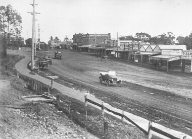
... Written on rear of backing sheet of large copy: "Early days of Ringwood commercial centre. Present frontage of Eastland to Maroondah Highway." ...Ringwood and District Historical Society 125A Warrandyte Road Ringwood North melbourne Written on rear of backing sheet of large copy: "Early days of Ringwood commercial centre. Present frontage of Eastland to Maroondah Highway." ...Black and white photograph (2 copies- 1 large, 1 small)Written on rear of backing sheet of large copy: "Early days of Ringwood commercial centre. Present frontage of Eastland to Maroondah Highway." Image shows Main Street with motor cars and horse drawn vehicles in front of shops. -
 Eltham District Historical Society Inc
Photograph, Liz Pidgeon, Commercial Place, Eltham, 15 April 2011, 15 April 2011
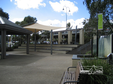
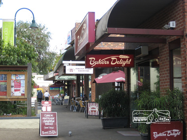
... ...commercial place...shopping centre...Eltham District Historical Society Inc 728 Main Rd Eltham melbourne Streetscape and shop developments eltham commercial place shopping centre Born Digital Commercial Place, Eltham, 15 April 2011 Photograph Liz Pidgeon ...Streetscape and shop developmentsBorn Digitaleltham, commercial place, shopping centre -
 Eltham District Historical Society Inc
Photograph, Liz Pidgeon, Commercial Place, Eltham, 15 April 2011, 15 April 2011
... ...commercial place...shopping centre...Eltham District Historical Society Inc 728 Main Rd Eltham melbourne Streetscape and shop developments eltham commercial place shopping centre Born Digital Commercial Place, Eltham, 15 April 2011 Photograph Liz Pidgeon ...Streetscape and shop developmentsBorn Digitaleltham, commercial place, shopping centre -
 Port Melbourne Historical & Preservation Society
Drawing - Property sketch - Garden City Shops, Centre Avenue, 1990s
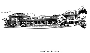
... Commercial...Garden City...Centre...Port Melbourne Historical & Preservation Society Port Melbourne Town Hall 333 Bay Street Port Melbourne melbourne Frank Gordon & Co Built Environment - Commercial Garden City Centre Avenue Property sketches done for Frank Gordon Real Estate in the 1990s. ...Property sketches done for Frank Gordon Real Estate in the 1990s. Garden City Shops, Centre Avenue [Note: Caption says Centre Rd rather than Centre Avenue]frank gordon & co, built environment - commercial, garden city, centre avenue -
 Port Melbourne Historical & Preservation Society
Photograph - Vintage Fire Engine, Fire in the Borough Launch, David Thompson, 2008
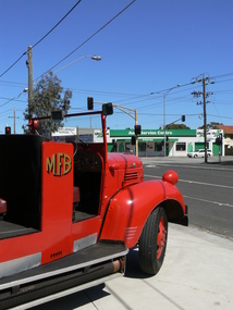
... Commercial...Autotune Service Centre...Fire in the Borough Celebrations Fetes and Exhibitions Port Melbourne Historical & Preservation Society PMHPS Fire and Fire Services Built Environment - Commercial Autotune Service Centre Graham Street Williamstown Road Digital colour photograph of the Fargo vintage fire engine at the Fire in the Borough launch at Port Melbourne Fire Station No 39 looking across Graham Street towards the Autotune Service Centre on the corner of Williamstown Road. ...Fire in the Borough (2007) by Shirley A VIDEION was launched in 2008 at the Port Melbourne Fire Station No 39 at the corner of Williamstown Road and Graham Street. Current Fire Fighter, Station Officer Phillip BENCRAFT was special guest to help launch the book. Phillip is the great-grand nephew of William BENCRAFT who was appointed Superintendent of the United Insurance Companies' Brigade in March, 1858.Digital colour photograph of the Fargo vintage fire engine at the Fire in the Borough launch at Port Melbourne Fire Station No 39 looking across Graham Street towards the Autotune Service Centre on the corner of Williamstown Road.fire in the borough, celebrations fetes and exhibitions, port melbourne historical & preservation society, pmhps, fire and fire services, built environment - commercial, autotune service centre, graham street, williamstown road -
 Ballarat Heritage Services
Photograph - Digital photographs, Fiveways (Denmark, Studley Park, Princess, High, High South) from Kew Junction (Cotham and High), c2017
... centre...commercial...Ballarat Heritage Services PO Box 2209 Bakery Hill Post Office goldfields kew kew junction five ways streetscape cotham road high street road shop shopping centre strip shopping centre commercial Digital images of Kew Junction. ...Digital images of Kew Junction.kew, kew junction, five ways, streetscape, cotham road, high street, road, shop, shopping centre, strip shopping centre, commercial -
 Emerald Museum & Nobelius Heritage Park
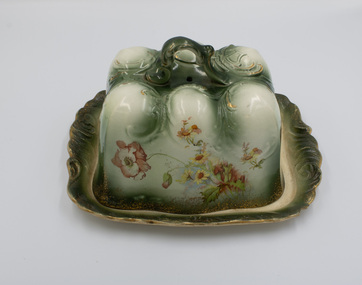
Ceramic - Ceramic cruet set consisting of stand, pepper container & salt container
... Silver Wells became the commercial centre of the early Gembrook settlement with shops, post office etc. ...Silver Wells became the commercial centre of the early Gembrook settlement with shops, post office etc. ...This cruet set was owned by the Ure family. Scottish migrants, John and Jane Ure settled on acreage north of Gembrook in 1874. They called their property 'Silver Wells' because of finding a pure and plentiful water source when digging their initial well. Silver Wells became the commercial centre of the early Gembrook settlement with shops, post office etc. When the train came through in 1900 the Gembrook commercial centre shifted to its present location, near the railway station. The Ure family continued to play a significant role in the Gembrook community. Items were donated by Jean WorrellThe Ure family of 'Silver Wells' was significant in the early history of Gembrook.Ceramic cruet set consisting of a stand with a handle and containing a pepper container and salt container which are removable. Red floral decoration with some green on a white background. Gold rim.1889, silver wells -
 Emerald Museum & Nobelius Heritage Park
Book - Fiction Book, Harriet Beecher Stowe, Uncle Tom's Cabin, 1889
... Silver Wells became the commercial centre of the early Gembrook settlement with shops, post office etc. ...Silver Wells became the commercial centre of the early Gembrook settlement with shops, post office etc. ...This book, Uncle Tom's Cabin was the best selling novel in the 19th century in the USA. It was given to Alexander Ure in 1889, the son of Scottish migrants, John and Jane Ure who settled on acreage north of Gembrook in 1874. They called their property 'Silver Wells' because of finding a pure and plentiful water source when digging their initial well. Silver Wells became the commercial centre of the early Gembrook settlement with shops, post office etc. When the train came through in 1900 the Gembrook commercial centre shifted to its present location, near the railway station. The Ure family continued to play a significant role in the Gembrook community.The Ure family of 'Silver Wells' was significant in the early history of Gembrook.Moss green hard cover book with title embossed on gold panel. 326 pages.On front cover printed: 'UNCLE TOM'S CABIN' On page i handwritten: 'Alexander Ure / A Present / from Mr & Mrs Wood / Cot 3rd 1889'alexander ure, uncle tom's cabin, 1889, silver wells -
 Emerald Museum & Nobelius Heritage Park
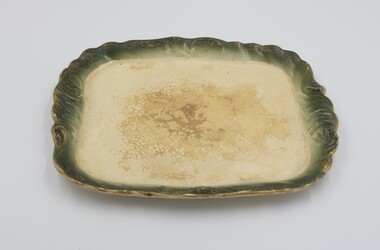
Ceramic - Ceramic cheese cover
... Silver Wells became the commercial centre of the early Gembrook settlement with shops, post office etc. ...Silver Wells became the commercial centre of the early Gembrook settlement with shops, post office etc. ...This cheese plate and cover which is probably Edwardian was owned by the Ure family. Scottish migrants, John and Jane Ure settled on acreage north of Gembrook in 1874. They called their property 'Silver Wells' because of finding a pure and plentiful water source when digging their initial well. Silver Wells became the commercial centre of the early Gembrook settlement with shops, post office etc. When the train came through in 1900 the Gembrook commercial centre shifted to its present location, near the railway station. The Ure family continued to play a significant role in the Gembrook community. Items were donated by Jean WorrellThe Ure family of 'Silver Wells' was significant in the early history of Gembrook. This ornate cheese cover is indicative of their prosperity.Ornate rectangular ceramic cheese cover with handle on top and floral design on all four sides.silver wells, ure, 1900s -
 Emerald Museum & Nobelius Heritage Park
Ceramic - Cheese Plate & Cover
... Silver Wells became the commercial centre of the early Gembrook settlement with shops, post office etc. ...Silver Wells became the commercial centre of the early Gembrook settlement with shops, post office etc. ...This ornate ceramic cheese plate and cover which is probably early 20th century was owned by the Ure family. Scottish migrants, John and Jane Ure. They settled on acreage north of Gembrook in 1874 which they called 'Silver Wells' because of finding a pure and plentiful water source when digging their initial well. Silver Wells became the commercial centre of the early Gembrook settlement with shops, post office etc. When the train came through in 1900 the Gembrook commercial centre shifted to its present location, near the railway station. The Ure family continued to play a significant role in the Gembrook community. Items were donated by Jean WorrellThe Ure family of 'Silver Wells' was significant in the early history of Gembrook. This ornate ceramic piece is indicative of their prosperity.Ceramic cheese cover and plate. Ornate design in green and white with floral design around all sides. Gold edging. Handle.silver wells, 1900s, ure -
 Emerald Museum & Nobelius Heritage Park
Ceramic - Plate
... Silver Wells became the commercial centre of the early Gembrook settlement with shops, post office etc. ...Silver Wells became the commercial centre of the early Gembrook settlement with shops, post office etc. ...This plate which is part of an ornate cheese cover and plate appears to be Edwardian. It was owned by the Ure family. Scottish migrants, John and Jane Ure, who settled on acreage north of Gembrook in 1874. They called their property 'Silver Wells' because of finding a pure and plentiful water source when digging their initial well. Silver Wells became the commercial centre of the early Gembrook settlement with shops, post office etc. When the train came through in 1900 the Gembrook commercial centre shifted to its present location, near the railway station. The Ure family continued to play a significant role in the Gembrook community. Items were donated by Jean WorrellThe Ure family of 'Silver Wells' was significant in the early history of Gembrook and this ornate ceramic piece is indicative of their prosperity.Green & White coloured ceramic plate which is part of a matching set comprising a cheese cover and plate.silver wells, ure, 1900s -
 Greensborough Historical Society
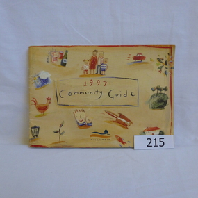
Book, Nillumbik Shire Council, 1997 Community Guide Nillumbik, 1997_
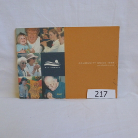
... The south of Nillumbik is predominantly urban, with commercial centres at Eltham and Diamond Creek. The north of the municipality includes significant natural features like Kinglake National Park and Sugarloaf Reservoir...The south of Nillumbik is predominantly urban, with commercial centres at Eltham and Diamond Creek. The north of the municipality includes significant natural features like Kinglake National Park and Sugarloaf Reservoir Annual guide to services in Nillumbik. nillumbik shire council handbooks 64 pages. ...Guide to services provided by Nillumbik Shire Council. Nillumbik Shire is located 25 kilometres north-east of Melbourne and the southern boundary is the Yarra River. The south of Nillumbik is predominantly urban, with commercial centres at Eltham and Diamond Creek. The north of the municipality includes significant natural features like Kinglake National Park and Sugarloaf ReservoirAnnual guide to services in Nillumbik. 64 pages. Cover is pale yellow with colour drawings. nillumbik shire council, handbooks -
 Greensborough Historical Society
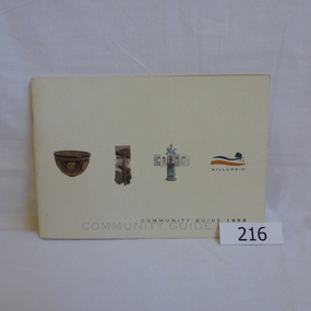
Book, Nillumbik Shire Council, 1998 Community Guide Nillumbik, 1998_
... The south of Nillumbik is predominantly urban, with commercial centres at Eltham and Diamond Creek. The north of the municipality includes significant natural features like Kinglake National Park and Sugarloaf Reservoir...The south of Nillumbik is predominantly urban, with commercial centres at Eltham and Diamond Creek. The north of the municipality includes significant natural features like Kinglake National Park and Sugarloaf Reservoir Annual guide to services in Nillumbik nillumbik shire council handbooks 72 pages. ...Guide to services provided by Nillumbik Shire Council. Nillumbik Shire is located 25 kilometres north-east of Melbourne and the southern boundary is the Yarra River. The south of Nillumbik is predominantly urban, with commercial centres at Eltham and Diamond Creek. The north of the municipality includes significant natural features like Kinglake National Park and Sugarloaf ReservoirAnnual guide to services in Nillumbik 72 pages. Cover has white background and some 3-D artwork.nillumbik shire council, handbooks -
 Greensborough Historical Society
Book, Nillumbik Shire Council, 1999 Community Guide Nillumbik, 1999_
... The south of Nillumbik is predominantly urban, with commercial centres at Eltham and Diamond Creek. The north of the municipality includes significant natural features like Kinglake National Park and Sugarloaf Reservoir...The south of Nillumbik is predominantly urban, with commercial centres at Eltham and Diamond Creek. The north of the municipality includes significant natural features like Kinglake National Park and Sugarloaf Reservoir Annual guide to services in Nillumbik nillumbik shire council handbooks 76 pages, illus. ...Guide to services provided by Nillumbik Shire Council. Nillumbik Shire is located 25 kilometres north-east of Melbourne and the southern boundary is the Yarra River. The south of Nillumbik is predominantly urban, with commercial centres at Eltham and Diamond Creek. The north of the municipality includes significant natural features like Kinglake National Park and Sugarloaf ReservoirAnnual guide to services in Nillumbik76 pages, illus. Cover has photographs of local people and title in white on orange background.nillumbik shire council, handbooks -
 Greensborough Historical Society
Book, Nillumbik Shire Council, Nillumbik Community Guide 2000/2001, 2000-2001
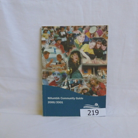
... The south of Nillumbik is predominantly urban, with commercial centres at Eltham and Diamond Creek. The north of the municipality includes significant natural features like Kinglake National Park and Sugarloaf Reservoir...The south of Nillumbik is predominantly urban, with commercial centres at Eltham and Diamond Creek. The north of the municipality includes significant natural features like Kinglake National Park and Sugarloaf Reservoir Annual guide to services in Nillumbik nillumbik shire council handbooks 76 pages, black and white illustrations. ...Guide to services provided by Nillumbik Shire Council. Nillumbik Shire is located 25 kilometres north-east of Melbourne and the southern boundary is the Yarra River. The south of Nillumbik is predominantly urban, with commercial centres at Eltham and Diamond Creek. The north of the municipality includes significant natural features like Kinglake National Park and Sugarloaf ReservoirAnnual guide to services in Nillumbik76 pages, black and white illustrations. Cover has a collage of local children with title in white on mid-blue background.nillumbik shire council, handbooks -
 Mission to Seafarers Victoria
Manual - Manual, Ship engineering, Ruston TA Gas Turbine, mid 20th
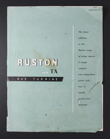
... Commercially printed light blue centre stapled soft cover booklet...The memorabilia relates to his career at sea and in particular the role of an engineer, including a handwritten manual of notes and references relating to the mechanical and engineering aspects and areas of responsibility for maintenance. gas turbines manual ruston george winfield duncan (1922-2017) ship engineer s.s. athenic promotional description down right side of front cover and diagrams of the turbine engines, white outline, on back blue cover Commercially printed light blue centre stapled soft cover booklet Ruston TA Gas Turbine Manual Manual, Ship engineering ...Found amongst the collection of material donated by Mr G W Duncan. This book dates approx to period 1960s-70s. Mariner Duncan had a particular regard for the Mission to Seafarers. This plate for display in the MTSV chapel acknowledges his bequest and the material donated. Collectively the G W Duncan material includes: photographs, professional data memorabilia and written and commercially printed resources. The memorabilia relates to his career at sea and in particular the role of an engineer, including a handwritten manual of notes and references relating to the mechanical and engineering aspects and areas of responsibility for maintenance. Commercially printed light blue centre stapled soft cover bookletpromotional description down right side of front cover and diagrams of the turbine engines, white outline, on back blue covergas turbines, manual, ruston, george winfield duncan (1922-2017), ship engineer, s.s. athenic -
 Sunbury Family History and Heritage Society Inc.
Photograph, Commercial Stores
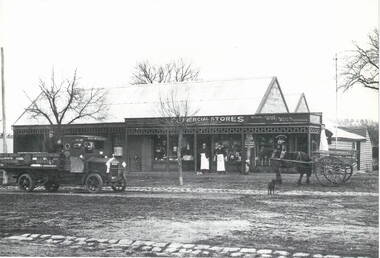
... He later built the Commercial Hotel also in Macedon Street and near the Ballcourt Hotel.Before the railway arrived in Sunbury, Macedon Street was Sunbury's main commercial centre. After the establishment of the railway, the commercial centre shifted close to the railway station. ...He later built the Commercial Hotel also in Macedon Street and near the Ballcourt Hotel.Before the railway arrived in Sunbury, Macedon Street was Sunbury's main commercial centre. After the establishment of the railway, the commercial centre shifted close to the railway station. ...Commercial Stores was owned and run by Peter Eadie from Perthshire in Scotland, whose brothers were John and Robert. Peter and Robert arrived in Sunbury in 1864 to help their brother John with his milling enterprise. In 1866, Peter purchased the blue stone general store in Macedon Street near the bridge. He later built the Commercial Hotel also in Macedon Street and near the Ballcourt Hotel.Before the railway arrived in Sunbury, Macedon Street was Sunbury's main commercial centre. After the establishment of the railway, the commercial centre shifted close to the railway station. The Eadie family's stately home, 'Dunblane', was on the corner of Brook and Jackson Street.A Lutheran Church now occupies the lower section of the land fronting Brook Street, but the home has a local heritage listing. Peter Eadie became a Shire of Bulla councillor and President in 1880. Dunblane is from the Scots Gaelic -'dun' is a fortified hill and 'Blane' a missionary.The Eadie Family established one of Sunbury's general stores in the town and were involved in many other commercial activities.A print of a non-digital black and white photograph of a country general store. A medium sized vintage open tray truck is parked in front of the shop on the LHSand a horse-drawn open cart is on the RHS of the image.eadie family, peter eadie, commercial stores, macedon street, businesses -
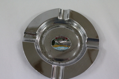 Wodonga & District Historical Society Inc
Memorabilia - Souvenir Ashtray Hume Weir Wodonga
... The pictures on the souvenirs ranged across natural beauty spots (beaches, waterfalls, rivers), civic buildings and monuments (town halls, war memorials), and indicators of local progress (commercial centres and occasionally even industrial sites)....The pictures on the souvenirs ranged across natural beauty spots (beaches, waterfalls, rivers), civic buildings and monuments (town halls, war memorials), and indicators of local progress (commercial centres and occasionally even industrial sites). ...Metal, china and glass ashtrays and other small pieces carrying scenic views of holiday destinations were a popular kind of souvenir during much of the 20th century. The pictures on the souvenirs ranged across natural beauty spots (beaches, waterfalls, rivers), civic buildings and monuments (town halls, war memorials), and indicators of local progress (commercial centres and occasionally even industrial sites).This ashtray is representative of a range of souvenirs used in the 20th century to depict Wodonga, Victoria and also on a State and National level throughout Australia.A metal circular ashtray including a coloured enamel image of the Hume Weir in the cenre."Above the central image "HUME WEIR" Beneath the central image "WODONGA"souvenir, hume weir, wodonga, ashtray -
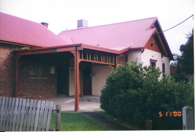 Sunbury Family History and Heritage Society Inc.
Photograph, Marilyn Bray, 5th November 2000
... Some time after 2010 it was demolished, along with a number of other adjacent cottages in Horne Street, to make way for a drive-in commercial centre....Some time after 2010 it was demolished, along with a number of other adjacent cottages in Horne Street, to make way for a drive-in commercial centre. Neill Street Horne Street Housing Medical Centres Sunbury A non-digital coloured photograph of a partial view of a sizeable house that has been built in stages with the remains of an unpainted wooden picket fence in the front and low growing shrubs in the garden. ...Over the years, this building, at the corner of Neill and Horne Streets, has had a number of uses. The original weatherboard structure was a farmhouse before the surrounding farmland was subdivided. It then became a private house. In the 1990s the brick section was added and the building was an x- ray centre. Some time after 2010 it was demolished, along with a number of other adjacent cottages in Horne Street, to make way for a drive-in commercial centre.A non-digital coloured photograph of a partial view of a sizeable house that has been built in stages with the remains of an unpainted wooden picket fence in the front and low growing shrubs in the garden. One section of the building is a brick structure with a pitched red corrugated iron/colourbond roof and the second section is built from cream painted weatherboards. A metal porch connects the two sections and a low ramp leads to the front door.neill street, horne street, housing, medical centres, sunbury -
 Warrnambool and District Historical Society Inc.
Book, Street Names of Colac, 2008
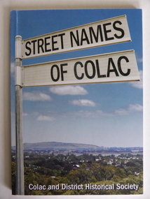
... Colac is a city 150 kilometres south west of Melbourne and is a commercial centre for a major agricultural area. ...Colac is a city 150 kilometres south west of Melbourne and is a commercial centre for a major agricultural area. ...This is a book giving information on the streets of Colac and the origins of the names. Colac is a city 150 kilometres south west of Melbourne and is a commercial centre for a major agricultural area. It is situated near the 3rd largest volcanic plain in the world and European settlement began in 1837. The book was commenced by Ian McIntosh in the 1970s and in 2005 the Colac and District Historical Society took on the project again with the major editors being Ida and Andrew McIntosh. This book is of interest, particularly those in the Western District of Victoria, as it contains information on Colac streets, many of which were named after pioneers of the district. The book will be useful for research. This is a soft cover book of 60 pages. The cover has a blue background and features a colour photograph (mainly in green, blue and white tonings) of a panorama of the Colac district. The photograph extends over the front and back covers. The book contains the names and name origins of Colac streets in alphabetical order and many black and white photographs. The pages have a glued binding. Front Cover: ‘Street Names of Colac’ ‘Colac and District Historical Society’ history of colac, colac and district historical society, street names of colac, ian mcintosh -
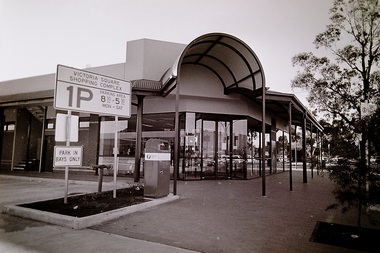 Sunshine and District Historical Society Incorporated
Photograph - St. Albans Post Office Cnr Elaine Street & Victoria Crescent St. Albans, The Advocate, 1993
... During the 1980's and 1990's, as the commercial centre of St. Albans shifted towards Alfrieda Street, on the east side of the railway line, Australian Post moved its post office closer to Alfrieda Street. ...Albans residents, Australia Post moved to a new location closer to the new St. Albans commercial centre. This photograph records the new post office in Victoria Square. ...The first St. Albans post office opened in 1888, just one year after the township was established in 1887. At this time, St Albans was little more than a railway station, a handful of houses, and Alfred Padley’s speculative subdivision. The location of the first post office changed over time, from the Railway Station to general stores and to the site on the corners of Main Road West and McKechnie Street. During the 1980's and 1990's, as the commercial centre of St. Albans shifted towards Alfrieda Street, on the east side of the railway line, Australian Post moved its post office closer to Alfrieda Street. To meet the needs of the St. Albans residents, Australia Post moved to a new location closer to the new St. Albans commercial centre. This photograph records the new post office in Victoria Square.5660 - St. Albans Post Office Cnr Elaine St And Victoria Cres - Opening (Sun Adv 143.3) 1993 Photo 01.JPGvictoria crescent, st. albans, st. albans post office, victoria square -
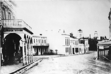 Stawell Historical Society Inc
Photograph, Upper Main Stawell Street looking East with London House on the left 1880
... London House on left, Commercial Hotel near centre of image. Two poppet heads of mines at right distance....London House on left, Commercial Hotel near centre of image. Two poppet heads of mines at right distance. ...Upper Main Street looking East. c 1880. Chadwick's Draper / Liddiard's / London House on left. Commercial Hotel, Oriental Bank / Bank of Australia, Punchard Furniture, Earlier Union Bank. Extended Cross Reef and Sloane and Scotchmans poppet Heads in Background.Street scene of north side of upper Main Street looking east. London House on left, Commercial Hotel near centre of image. Two poppet heads of mines at right distance.stawell streetscape