Showing 130 items matching "condition of trees"
-
 Friends of Ballarat Botanical Gardens History Group
Work on paper - National Trust of Australia (Vic), Tour of the Ballarat Botanical Gardens 1992-93, 1992-1993
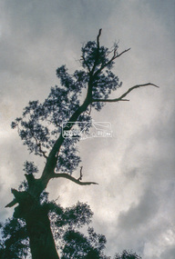
... of trees...Condition of trees...This listing of trees at this time is important in terms of the subsequent millennial drought and in giving details of where each tree is situated in the Gardens and the condition of each tree....John Garner Doctor John Garner Collection Ballarat Botanical Gardens Trees in the Ballarat Botanical Gardens National Trust of Australia (Vic) Trees in 1992-93 Location of trees Condition of trees Botanic names of trees. Friends of Ballarat Botanical Gardens Gardens Ballarat None 4 pages printed on both sides, faint though legible grey print. 3 and 1/4 printed pages. ...This listing of trees at this time is important in terms of the subsequent millennial drought and in giving details of where each tree is situated in the Gardens and the condition of each tree.The Ballarat Botanical Gardens has a notable collection of trees, which are important in the history of Ballarat and for citizens and visitors to this City.4 pages printed on both sides, faint though legible grey print. 3 and 1/4 printed pages.Nonejohn garner, doctor, john garner collection, ballarat botanical gardens, trees in the ballarat botanical gardens, national trust of australia (vic), trees in 1992-93, location of trees, condition of trees, botanic names of trees., friends of ballarat botanical gardens, gardens, ballarat -
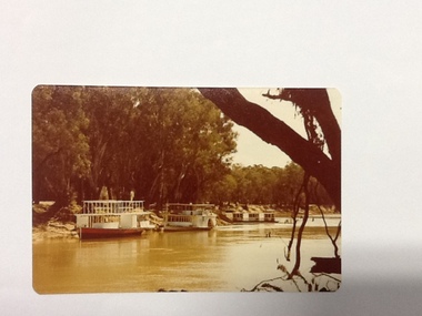 Port of Echuca
Colour Photograph, Approx.1979
... trees but the swimming pool isn't visible. There is another river boat behind, possibly the Canberra. This photograph is of historical and social significance in that it shows the condition of the Murray river in the 1970's at an area used as the local swimming area on the Echuca side of the river. ...This photo shows a river boat under construction on the eastern bank of the Murray river in the Echuca Port area where the boat shed and swimming pool were located in the 1970's. The boat shed can be seen through the trees but the swimming pool isn't visible. There is another river boat behind, possibly the Canberra.This photograph is of historical and social significance in that it shows the condition of the Murray river in the 1970's at an area used as the local swimming area on the Echuca side of the river. There is a river boat under construction (the frame work shows a bottom and top storey on the boat). This could be the Pride of the Murray. It is difficult to see the name on the river boat behind but it looks like the Canberra. Three houseboats are moored together, a bit further down the river.Colour photograph (post card size) of the Murray river looking north towards the boat shed building. Two river boats are moored by the left bank close to the swimming pool and three house boats can be seen moored further down the river. The river boat in the fore ground is under construction.Printed on reverse:" this paper manufactured by Kodak". Written in blue pen"12B"echuca, port of (riverboats), echuca, port of -
 The Beechworth Burke Museum
Photograph - Photographs, c1900
... condition. This could give an indication that either boating was not a popular activity or that this boathouse in particular was not well looked after. Boathouse Lake Lake Kerferd man stereoscopic Beechworth Lake Beechworth Victoria trees boat wooden house A03074.2 obverse: Lake Kerferd/ Beechworth/ Black and white photograph mounted on card Photograph Photographs ...Both of these stereoscopic images depict a man standing by Lake Kerferd in Beechworth. The boathouse is located behind him. Lake Kerferd is significant because it was created in 1862 and Beechworth's main water supply. These images depict how Lake Kerferd was once used for boats because of the boathouse shown in the background of the image. However this boathouse appears to be in poor condition. This could give an indication that either boating was not a popular activity or that this boathouse in particular was not well looked after. Black and white photograph mounted on cardA03074.2 obverse: Lake Kerferd/ Beechworth/boathouse, lake, lake kerferd, man, stereoscopic, beechworth lake, beechworth, victoria, trees, boat, wooden house -
 Greensborough Historical Society
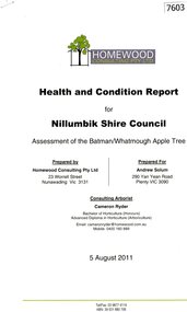
Document - Report, Homewood Consulting Pty Ltd, Assessment of the Batman / Whatmough Apple Tree, 2011, 05/08/2011
... A health and condition report for Nillumbik Shire Council on the Batman / Whatmough Apple Tree. ...Greensborough Historical Society 34A Glenauburn Road Lower Plenty Lower Plenty melbourne A health and condition report for Nillumbik Shire Council on the Batman / Whatmough Apple Tree. ...A health and condition report for Nillumbik Shire Council on the Batman / Whatmough Apple Tree. Prepared by Homewood Consulting in 2011The Batman Apple tree is said to be over 170 years old, being brought to Greensborough in the 1840s from the Melbourne orchard of John Batman, following Batman's death in 1839.9 page photocopy, text and colour illustrations.batman apple tree, robert whatmough, nillumbik council, plenty river trail -
 Halls Gap & Grampians Historical Society
Photograph - B/W, After 1900
... condition. Small front yard enclosed in picket fence, bracken in forefront and eocalypt trees at rear....condition. Small front yard enclosed in picket fence, bracken in forefront and eocalypt trees at rear. ...Cottage once stood in the Mafeking area and was owned in the 1920s/1930s by a prospector and timber worker, name unknown.Wooden slab cottage with corrugated iron roof in apparent good condition. Small front yard enclosed in picket fence, bracken in forefront and eocalypt trees at rear.buildings, houses -
 Halls Gap & Grampians Historical Society
Photograph - B/W, C 1960s
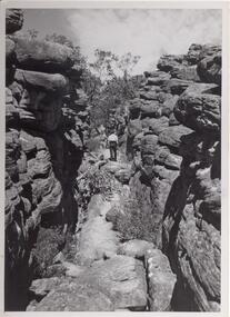
... condition that it is acknowledged as 'Victorian Railways Photograph', p3456- Silent Street . Halls Gap. Photo shows a man walking along slabs of rock that form a path between rocky outcrops. He is walking away from the camera. Various shrubs line the path. Gum trees ...Photo is of area known as ' Silent Street'. It is on path to Pinnacle Lookout.Photo shows a man walking along slabs of rock that form a path between rocky outcrops. He is walking away from the camera. Various shrubs line the path. Gum trees can be seen in background.'Copyright photograph'. This photograph may be reproduced on condition that it is acknowledged as 'Victorian Railways Photograph', p3456- Silent Street . Halls Gap.scenery, wonderland range -
 Halls Gap & Grampians Historical Society
Photograph - B/W
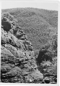
... condition that it is acknowledged as 'VICTORIAN RAILWAYS PHOTOGRAPH'. P3484 Written in pencil. The Grand Canyon Halls Gap written in blue pen shows a rocky escarpment on the left with a range covered with trees in the background Photograph B/W ...The area is known as The Grand Canyon on t The Pinnacle track. Photo is typical of tourism photos taken by the Victorian Railways during this period. c1950 -60'sshows a rocky escarpment on the left with a range covered with trees in the backgroundPrinted on back: Copyright Photograph. This photograph may be reproduced on condition that it is acknowledged as 'VICTORIAN RAILWAYS PHOTOGRAPH'. P3484 Written in pencil. The Grand Canyon Halls Gap written in blue penscenery, wonderland range -
 Halls Gap & Grampians Historical Society
Photograph - B/W
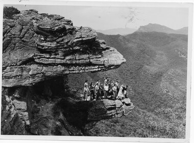
... condition that it is acknowledged a s 'VICTORIAN RAILWAYS PHOTOGRAPH'. P3465 written faintly in pencil. The Balconies Halls Gap written in blue pen a group of people (17) standing on a rocky ledge overlooking a treed valley. a second rock ledge is above them creating the impression of a large mouth. ...Viewing area is known as The Balconies overlooking Victoria Valley. Photo is typical of tourism photos taken by the Victorian Railways during this period. c1950 -60'sa group of people (17) standing on a rocky ledge overlooking a treed valley. a second rock ledge is above them creating the impression of a large mouth. Printed on back: Copyright Photograph. This photograph may be reproduced on condition that it is acknowledged a s 'VICTORIAN RAILWAYS PHOTOGRAPH'. P3465 written faintly in pencil. The Balconies Halls Gap written in blue penscenery, lookouts -
 Phillip Island and District Historical Society Inc.
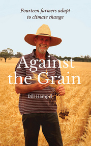
Book, Bill Hampel, Against the grain : fourteen farmers adapt to climate change, 2015
... condition than when they first purchased or inherited it. With crops or livestock, big or small, they have worked cooperatively, mostly through land management, to plant thousands of trees, which has led to the daily presence of over 100 bird species. ...condition than when they first purchased or inherited it. With crops or livestock, big or small, they have worked cooperatively, mostly through land management, to plant thousands of trees, which has led to the daily presence of over 100 bird species. ...Can we humans simply ignore the fires, the floods, and the increase in deaths brought about by climate change? In this book, Australian farmers - who bear the brunt of climate change, yet accept the science - share their experiences with the unpredictable weather events, the reduction in rainfall, and the shift to hotter months which are a challenge to farming cycles. Far from contributing to the problem with their farming practices, these farmers demonstrate how to reduce their greenhouse gases - to zero or below in some cases - while remaining profitable. They are all committed to pass on their farm in a better condition than when they first purchased or inherited it. With crops or livestock, big or small, they have worked cooperatively, mostly through land management, to plant thousands of trees, which has led to the daily presence of over 100 bird species. The farmers' inspiring and informative stories will open up a new world to most urban dwellers. A summary of climate change impacts - and an account of the numerous economic, political, and media barriers toward change - combine to provide a context for their work. 280 pages : colour illustrations, colour maps, colour portraits ; 23 cm. Includes bibliographical references and index. Also available in digital formats: ebook & epdf. ISBN 9781925078503 Dewey number 338.10994 Chapter 5 : Bob & Anne Davie Donor : Anne Davie ; Date : 14.10.2015.agriculture -- environmental aspects -- australia., farmers -- australia -- economic conditions., rural development -- australia., climatic changes -- australia. -
 Eltham District Historical Society Inc
Slide - Photograph, Unidentified significant tree, Eltham district, c.Feb. 1993
... trees that covered the area before settlement. Measurements: 11/1981 Spread (m): 23 Girth (m): 4.3 Height (m): 42 Estimated Age (yrs): 250+ Condition: Good Measurements: 20/09/2010 Spread (m): EW 20 NS 23 Girth (m): 4..5 Height (m): 40 Estimated Age (yrs): 250+ Condition: Access: Unrestricted Classified: 17/02/1983...trees that covered the area before settlement. Measurements: 11/1981 Spread (m): 23 Girth (m): 4.3 Height (m): 42 Estimated Age (yrs): 250+ Condition: Good Measurements: 20/09/2010 Spread (m): EW 20 NS 23 Girth (m): 4..5 Height (m): 40 Estimated Age (yrs): 250+ Condition: Access: Unrestricted Classified: 17/02/1983 Unidentified Significant Tree 35mm colour positive transparency (1 of 3) Mount - Kodak Ektachrome Unidentified significant tree, Eltham district Slide Photograph ...Possibly the Yellow Box, Eucalyptus melliodora, Laughing Waters Road, Eltham 80 m from Reynolds Road http://vhd.heritagecouncil.vic.gov.au/places/71057 Outstanding size Outstanding specimen Located 80m from Reynolds Road, this tree is one of the few remaining forest trees that covered the area before settlement. Measurements: 11/1981 Spread (m): 23 Girth (m): 4.3 Height (m): 42 Estimated Age (yrs): 250+ Condition: Good Measurements: 20/09/2010 Spread (m): EW 20 NS 23 Girth (m): 4..5 Height (m): 40 Estimated Age (yrs): 250+ Condition: Access: Unrestricted Classified: 17/02/198335mm colour positive transparency (1 of 3) Mount - Kodak Ektachromeunidentified, significant tree -
 Eltham District Historical Society Inc
Negative - Photograph, Cottlesbridge-Strathewen Road, Strathewen, c.Nov. 1987
... Photos taken during a review of road and bridge/culvert condition by Eltham Shire Council engineers. A number of the trees were badly burnt or destroyed in the Black Saturday bushfire, 7 Feb. 2009 but some remained standing and identifiable as of 2014 (Google Streetview)....Eltham District Historical Society Inc 728 Main Rd Eltham melbourne Photos taken during a review of road and bridge/culvert condition by Eltham Shire Council engineers. A number of the trees were badly burnt or destroyed in the Black Saturday bushfire, 7 Feb. 2009 but some remained standing and identifiable as of 2014 (Google Streetview). bridge chads creek chads creek road cottlesbridge-strathewen road culvert infrastructure roads school ridge road strathewen Kodak GB 200 5096 Roll of 35mm colour negative film, 4 strips Cottlesbridge-Strathewen Road, Strathewen Negative Photograph ...Photos taken during a review of road and bridge/culvert condition by Eltham Shire Council engineers. A number of the trees were badly burnt or destroyed in the Black Saturday bushfire, 7 Feb. 2009 but some remained standing and identifiable as of 2014 (Google Streetview).Roll of 35mm colour negative film, 4 stripsKodak GB 200 5096bridge, chads creek, chads creek road, cottlesbridge-strathewen road, culvert, infrastructure, roads, school ridge road, strathewen -
 Eltham District Historical Society Inc
Scrapbook Page, Scrapbook page of photos, Eltham, 1920s to 1940s
... He retired at Hawthorn Police Station in 1931, described by Hawthorn Council in 1927 as in a disgraceful condition and unfit for human habitation (Kathryn Griffin family tree – Ancestry) whereupon they moved to 28 Saunders Street, Coburg. ...Pages from a scrapbook belonging to Heather Jenkins (nee Cone) who lived as a child in the Police Residence at 728 Main Road, Eltham from 1911 till the early 1920s.Heather McKnight Jenkins (nee Cone) was born 1911, possibly at the Eltham Police Residence and spent her childhood growing up in the Police Residence. Heather was the daughter of John Thomas Cone, Police Constable, and Charlotte Helena Cone (nee Black) who had married in 1906. Constable Cone was transferred to Eltham Police Station from Lauriston (near Kyneton) in May 1911. He retired from the force around September 1922 most likely as a result of significant health concerns experienced earlier that year from 22 April when he was hospitalised. He died 5 October 1922 at Maria Street at age 60 leaving behind a widow and two daughters; his son having pre-deceased him as a result of effects of the war. He is buried in Melbourne General Cemetery . In his probate it states that he owned a piece of land 200 links frontage to Maria Street and a depth of 241 links. It is believed that this is the land opposite the Police Station which Heather Jenkins referred to as being owned by her father and where he agisted the Police horses. Heather, her sister and mother Charlotte remained in Eltham until at least the 1924 Electoral Roll where Charlotte was listed as Home Duties however by 1925 she was listed at 229 Glenferrie Road, Malvern, occupation, Registrar of Births. In the 1934 (and 1936) Electoral Roll, Heather was a Clerk and her mother Charlotte was the Registrar of Births. in 1952 following her mother’s death she made application for Grant of Probate. Heather remains listed in the 1954 Electoral Roll at 13 Ashburton Road under her maiden name Cone however by the 1963 Electoral Roll she is listed at the same address as Heather McKnight Jenkins long with James Gardiner Jenkins. Neither appear listed in the 1958 Electoral Roll. James Gardiner Jenkins (1892-1975) first wife was Fanny Davison Carrucan (1899-1929), daughter of Denis Carrucan and Jane (nee McAleese). They married in 1925. Fanny died 11 November 1929. In the 1934 Electoral Roll he remained listed at John Street, Eltham, Railway Employee however by 1935 Electoral Roll, James Gardiner Jenkins, Railway Employee, was listed at 229 Glenferrie Road, Malvern and he remained living with Charlotte and Heather Cone when they moved to 13 Ashburton Road, Glen Iris. One of Constable Cone’s first investigations upon arriving in Eltham was the accidental fatal shooting in the head with a pea rifle by young Francis August Capewell, aged 11, of John Sutcliffe Deegan, 14, in Maria Street near the Railway. Constable Cone’s replacement was Constable William Charles Sargeant who commenced in charge of the Eltham Police Station from Thursday, 10 August 1922. Constable William Charles Sargeant, and his wife Elizabeth Agnes Sargeant were based at the Eltham Police Station until his transfer to the Police Station in Burwood Road, Hawthorn. He retired at Hawthorn Police Station in 1931, described by Hawthorn Council in 1927 as in a disgraceful condition and unfit for human habitation (Kathryn Griffin family tree – Ancestry) whereupon they moved to 28 Saunders Street, Coburg. Elizabeth died 16 July 1936 in Fitzroy. William then moved to 6 Queen Street Coburg in 1936 and then 1 Queen Street in 1942 where he died 7 August 1944. He is buried at Fawkner Cemetery. Brown paper scrapbook page (torn from scrapbook) with 8 black and white/sepia photos of varying sizes, 1 newspaper clipping and one greeting card with printed sketch and handwritten captions in ink. On back of page is 1 black and white photo and a large newspaper clipping.eltham, police residence, walter withers, heather mcknight jenkins (nee cone), constable john thomas cone, charlotte helena cone (nee black) -
 Eltham District Historical Society Inc
Memorabilia - Scrapbook Page, Scrapbook page of photos, Eltham, 1920s to 1940s
... He retired at Hawthorn Police Station in 1931, described by Hawthorn Council in 1927 as in a disgraceful condition and unfit for human habitation (Kathryn Griffin family tree – Ancestry) whereupon they moved to 28 Saunders Street, Coburg. ...Pages from a scrapbook belonging to Heather Jenkins (nee Cone) who lived as a child in the Police Residence at 728 Main Road, Eltham from 1911 to the early 1920s.Heather McKnight Jenkins (nee Cone) was born 1911, possibly at the Eltham Police Residence and spent her childhood growing up in the Police Residence. Heather was the daughter of John Thomas Cone, Police Constable, and Charlotte Helena Cone (nee Black) who had married in 1906. Constable Cone was transferred to Eltham Police Station from Lauriston (near Kyneton) in May 1911. He retired from the force around September 1922 most likely as a result of significant health concerns experienced earlier that year from 22 April when he was hospitalised. He died 5 October 1922 at Maria Street at age 60 leaving behind a widow and two daughters; his son having pre-deceased him as a result of effects of the war. He is buried in Melbourne General Cemetery . In his probate it states that he owned a piece of land 200 links frontage to Maria Street and a depth of 241 links. It is believed that this is the land opposite the Police Station which Heather Jenkins referred to as being owned by her father and where he agisted the Police horses. Heather, her sister and mother Charlotte remained in Eltham until at least the 1924 Electoral Roll where Charlotte was listed as Home Duties however by 1925 she was listed at 229 Glenferrie Road, Malvern, occupation, Registrar of Births. In the 1934 (and 1936) Electoral Roll, Heather was a Clerk and her mother Charlotte was the Registrar of Births. in 1952 following her mother’s death she made application for Grant of Probate. Heather remains listed in the 1954 Electoral Roll at 13 Ashburton Road under her maiden name Cone however by the 1963 Electoral Roll she is listed at the same address as Heather McKnight Jenkins long with James Gardiner Jenkins. Neither appear listed in the 1958 Electoral Roll. James Gardiner Jenkins (1892-1975) first wife was Fanny Davison Carrucan (1899-1929), daughter of Denis Carrucan and Jane (nee McAleese). They married in 1925. Fanny died 11 November 1929. In the 1934 Electoral Roll he remained listed at John Street, Eltham, Railway Employee however by 1935 Electoral Roll, James Gardiner Jenkins, Railway Employee, was listed at 229 Glenferrie Road, Malvern and he remained living with Charlotte and Heather Cone when they moved to 13 Ashburton Road, Glen Iris. One of Constable Cone’s first investigations upon arriving in Eltham was the accidental fatal shooting in the head with a pea rifle by young Francis August Capewell, aged 11, of John Sutcliffe Deegan, 14, in Maria Street near the Railway. Constable Cone’s replacement was Constable William Charles Sargeant who commenced in charge of the Eltham Police Station from Thursday, 10 August 1922. Constable William Charles Sargeant, and his wife Elizabeth Agnes Sargeant were based at the Eltham Police Station until his transfer to the Police Station in Burwood Road, Hawthorn. He retired at Hawthorn Police Station in 1931, described by Hawthorn Council in 1927 as in a disgraceful condition and unfit for human habitation (Kathryn Griffin family tree – Ancestry) whereupon they moved to 28 Saunders Street, Coburg. Elizabeth died 16 July 1936 in Fitzroy. William then moved to 6 Queen Street Coburg in 1936 and then 1 Queen Street in 1942 where he died 7 August 1944. He is buried at Fawkner Cemetery. Brown paper scrapbook page (torn from scrapbook) with 9 black and white/sepia photos of varying sizes, 1 newspaper clipping and handwritten captions in ink.On verso in pencil "Const. W.C. Sargeant 1922-1927 - see Police list"eltham, police residence, constable w.c. sargeant, heather mcknight jenkins (nee cone), constable john thomas cone, charlotte helena cone (nee black) -
 Eltham District Historical Society Inc
Scrapbook Page, New Railway Line: Eltham to Hurst's Bridge; The Weekly Times, 24 Feb 1912, p27, 1912
... He retired at Hawthorn Police Station in 1931, described by Hawthorn Council in 1927 as in a disgraceful condition and unfit for human habitation (Kathryn Griffin family tree – Ancestry) whereupon they moved to 28 Saunders Street, Coburg. ...Pages from a scrapbook belonging to Heather Jenkins (nee Cone) who lived as a child in the Police Residence at 728 Main Road, Eltham from 1911 to the early 1920s. Images featured are 1. A peep on the road, nearing Research. 2. The Main Road at Eltham (opposite Railway Station). 3. A part of the new railway line. 4. The mail coach leaving for Kangaroo Ground.Heather McKnight Jenkins (nee Cone) was born 1911, possibly at the Eltham Police Residence and spent her childhood growing up in the Police Residence. Heather was the daughter of John Thomas Cone, Police Constable, and Charlotte Helena Cone (nee Black) who had married in 1906. Constable Cone was transferred to Eltham Police Station from Lauriston (near Kyneton) in May 1911. He retired from the force around September 1922 most likely as a result of significant health concerns experienced earlier that year from 22 April when he was hospitalised. He died 5 October 1922 at Maria Street at age 60 leaving behind a widow and two daughters; his son having pre-deceased him as a result of effects of the war. He is buried in Melbourne General Cemetery . In his probate it states that he owned a piece of land 200 links frontage to Maria Street and a depth of 241 links. It is believed that this is the land opposite the Police Station which Heather Jenkins referred to as being owned by her father and where he agisted the Police horses. Heather, her sister and mother Charlotte remained in Eltham until at least the 1924 Electoral Roll where Charlotte was listed as Home Duties however by 1925 she was listed at 229 Glenferrie Road, Malvern, occupation, Registrar of Births. In the 1934 (and 1936) Electoral Roll, Heather was a Clerk and her mother Charlotte was the Registrar of Births. in 1952 following her mother’s death she made application for Grant of Probate. Heather remains listed in the 1954 Electoral Roll at 13 Ashburton Road under her maiden name Cone however by the 1963 Electoral Roll she is listed at the same address as Heather McKnight Jenkins long with James Gardiner Jenkins. Neither appear listed in the 1958 Electoral Roll. James Gardiner Jenkins (1892-1975) first wife was Fanny Davison Carrucan (1899-1929), daughter of Denis Carrucan and Jane (nee McAleese). They married in 1925. Fanny died 11 November 1929. In the 1934 Electoral Roll he remained listed at John Street, Eltham, Railway Employee however by 1935 Electoral Roll, James Gardiner Jenkins, Railway Employee, was listed at 229 Glenferrie Road, Malvern and he remained living with Charlotte and Heather Cone when they moved to 13 Ashburton Road, Glen Iris. One of Constable Cone’s first investigations upon arriving in Eltham was the accidental fatal shooting in the head with a pea rifle by young Francis August Capewell, aged 11, of John Sutcliffe Deegan, 14, in Maria Street near the Railway. Constable Cone’s replacement was Constable William Charles Sargeant who commenced in charge of the Eltham Police Station from Thursday, 10 August 1922. Constable William Charles Sargeant, and his wife Elizabeth Agnes Sargeant were based at the Eltham Police Station until his transfer to the Police Station in Burwood Road, Hawthorn. He retired at Hawthorn Police Station in 1931, described by Hawthorn Council in 1927 as in a disgraceful condition and unfit for human habitation (Kathryn Griffin family tree – Ancestry) whereupon they moved to 28 Saunders Street, Coburg. Elizabeth died 16 July 1936 in Fitzroy. William then moved to 6 Queen Street Coburg in 1936 and then 1 Queen Street in 1942 where he died 7 August 1944. He is buried at Fawkner Cemetery. Large newspaper clipping (half page), very aged and fragile with sticky tape holding it together with 4 images of early Elthameltham, police residence, heather mcknight jenkins (nee cone), constable john thomas cone, charlotte helena cone (nee black) -
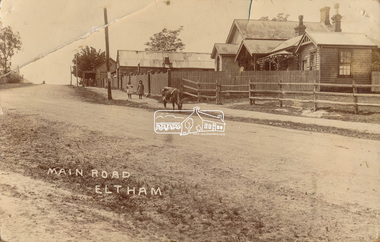 Eltham District Historical Society Inc
Photograph, J.H. Clark (poss), Main Road, Eltham, c.1910
... He retired at Hawthorn Police Station in 1931, described by Hawthorn Council in 1927 as in a disgraceful condition and unfit for human habitation (Kathryn Griffin family tree – Ancestry) whereupon they moved to 28 Saunders Street, Coburg. ...Original photo from a scrapbook belonging to Heather Jenkins (nee Cone) who lived as a child in the Police Residence at 728 Main Road, Eltham from 1911 to the early 1920s. (Reported in Newsletter No. 98, Sept., 1994). View looking north up Policeman’s Hill across Main Road towards the Police Station, Police Residence and Courthouse, c.1910 prior to Brougham Street being made. The two rails / gap in the fence would be where Brougham Street now enters Main Road. Also visible are Knapman's Forge adjacent to Courthouse and E.J. Andrew's Store on top of the hill At the upper left can be seen the front of the Evelyn Hotel. On the opposite corner was Watsons Hotel. E.J. Andrew's store with its verandah was on the corner of Franklin Street. Behind the picket fence stands the 1860 Court House and Police residence with the weatherboard clad Police office. The enclosed fence is now the end of Brougham Street, opened to Bible Street in 1926. The Evelyn Hotel (formerly Fountain of Friendship) burnt down in the 1930s when it was being used as a boarding house since 1919. A cow is feeding on the grass verge in street. The photo is identified in white lettering typical of the style of Clark Bros., photographers of Windsor, Melbourne (1894-1914). One of the brothers, John Henry Clark, took many early photos around Little Eltham and moved to Eltham in 1916 where he lived at the bottom of the hill. Typically, he would add “J.H. Clark Photo” to his personal work, but this is not evident. There is however some ghost writing, a cheeky inscription in small white lettering in the grass verge in front of where Brougham Street is, which appears to state: “Heather or Hannah was here”. Perhaps J.H. Clark took the photo during a trip to Eltham and gifted it some years later after moving there as a gift to a young Heather Cone. The Police Station sign: E vii R ELTHAM POLICE STATION HEIDELBERG DISTRICT Edward VII ascended the throne in 1901 and died 6 May 1910. He was succeeded by George V.Heather Cone was the daughter of Constable John Thomas Cone (Badge 3935) the local police officer in residence at Eltham, 1 May 1911 to 9 July 1922. Heather McKnight Jenkins (nee Cone) was born 1911, possibly at the Eltham Police Residence and spent her childhood growing up in the Police Residence. Heather was the daughter of John Thomas Cone, Police Constable, and Charlotte Helena Cone (nee Black) who had married in 1906. Constable Cone was transferred to Eltham Police Station from Lauriston (near Kyneton) in May 1911. He retired from the force around September 1922 most likely as a result of significant health concerns experienced earlier that year from 22 April when he was hospitalised. He died 5 October 1922 at Maria Street at age 60 leaving behind a widow and two daughters; his son having pre-deceased him as a result of effects of the war. He is buried in Melbourne General Cemetery . In his probate it states that he owned a piece of land 200 links frontage to Maria Street and a depth of 241 links. It is believed that this is the land opposite the Police Station which Heather Jenkins referred to as being owned by her father and where he agisted the Police horses. Heather, her sister and mother Charlotte remained in Eltham until at least the 1924 Electoral Roll where Charlotte was listed as Home Duties however by 1925 she was listed at 229 Glenferrie Road, Malvern, occupation, Registrar of Births. In the 1934 (and 1936) Electoral Roll, Heather was a Clerk and her mother Charlotte was the Registrar of Births. in 1952 following her mother’s death she made application for Grant of Probate. Heather remains listed in the 1954 Electoral Roll at 13 Ashburton Road under her maiden name Cone however by the 1963 Electoral Roll she is listed at the same address as Heather McKnight Jenkins long with James Gardiner Jenkins. Neither appear listed in the 1958 Electoral Roll. James Gardiner Jenkins (1892-1975) first wife was Fanny Davison Carrucan (1899-1929), daughter of Denis Carrucan and Jane (nee McAleese). They married in 1925. Fanny died 11 November 1929. In the 1934 Electoral Roll he remained listed at John Street, Eltham, Railway Employee however by 1935 Electoral Roll, James Gardiner Jenkins, Railway Employee, was listed at 229 Glenferrie Road, Malvern and he remained living with Charlotte and Heather Cone when they moved to 13 Ashburton Road, Glen Iris. One of Constable Cone’s first investigations upon arriving in Eltham was the accidental fatal shooting in the head with a pea rifle by young Francis August Capewell, aged 11, of John Sutcliffe Deegan, 14, in Maria Street near the Railway. Constable Cone’s replacement was Constable William Charles Sargeant who commenced in charge of the Eltham Police Station from Thursday, 10 August 1922. Constable William Charles Sargeant, and his wife Elizabeth Agnes Sargeant were based at the Eltham Police Station until his transfer to the Police Station in Burwood Road, Hawthorn. He retired at Hawthorn Police Station in 1931, described by Hawthorn Council in 1927 as in a disgraceful condition and unfit for human habitation (Kathryn Griffin family tree – Ancestry) whereupon they moved to 28 Saunders Street, Coburg. Elizabeth died 16 July 1936 in Fitzroy. William then moved to 6 Queen Street Coburg in 1936 and then 1 Queen Street in 1942 where he died 7 August 1944. He is buried at Fawkner Cemetery.Sepia postcard photo glued on a brown paper scrapbook page (torn from scrapbook) along with 8 other black and white/sepia photos of varying sizes, 1 newspaper clipping and handwritten captions in ink.brougham street, courthouse, cow, eltham, knapmans forge, little eltham, local history centre, main road, maria street, police residence, police station, policeman's hill, scrapbook, w.b. andrew corn store, j.h. clark photo, andrews store, heather jenkins (nee cone), clark bros. photo -
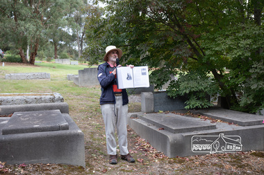 Eltham District Historical Society Inc
Photograph, Peter Pidgeon, Grave of Charlotte Amelia Taylor, Lillian Jane Taylor and Robert David Taylor, Eltham Cemetery, 5 April 2021
... In 1920, Council charged him with illegally felling 91 eucalyptus trees in Eltham Park (60% of them in a healthy condition), presumably to be sold as firewood. ...In 1920, Council charged him with illegally felling 91 eucalyptus trees in Eltham Park (60% of them in a healthy condition), presumably to be sold as firewood. ...Robert David Taylor was a farmer who lived in Eltham all his life and died in 1934 at the age of 76. Mr and Mrs Bowman lived in York Street; Taylor was their neighbour. In 1933 he subdivided his land, the plan showing a proposed Grey Street flanked by residential blocks for sale. Mrs Bowman bought one: her family would be able to walk through it and along Grey Street to Henry Street, thus providing quicker access to the railway station. But Taylor retained ownership of Grey Street itself. He fenced it off at each end and charged the Bowmans with trespass when they used it. The matter went to Court. The ruling was that Mrs Bowman could use Grey Street, as she owned land in it, but her husband could not. (Taylor also accused the Bowmans of having broken the fences, but could not prove it.) Taylor had wanted to subdivide his land in 1914. Plans were submitted to Council and were approved, but the subdivision did not proceed. In 1919, Taylor doctored the plans to make it appear that a totally different subdivisional arrangement had been approved. The Titles Office immediately detected fraud, and the Crown charged Taylor with forgery and counterfeiting. But charges were later dropped (reason not recorded). He was an Eltham Shire Councillor between 1911 and 1920. In 1920, Council charged him with illegally felling 91 eucalyptus trees in Eltham Park (60% of them in a healthy condition), presumably to be sold as firewood. He was imprisoned pending trial. Taylor claimed that he had acquired from another man the right to remove timber and sued the Council for wrongful prosecution. The case eventually went to the State Full Court, with judgement given in favour of Council, on the grounds that any right acquired by Taylor covered only the removal of logs and refuse, not sound green timber. And his position as Councillor precluded him from acquiring the right anyway. Robert David Taylor was also a Trustee of the Wesleyan Church owned land at Lot 20 Henry Street, originally purchased in January 1855 for a chapel and from which David and Catherine Clark first ran their private school, the forerunner of the Eltham Primary School. The land was sold in November 1901 to the Hope of Eltham Tent No. 195 Victoria District Independent Order of Rechabites, for which his brother William John Taylor was a Trustee and became the home of the Eltham Rechabite Hall. In December 1921 it was again sold, this time to the community for use as the Eltham Public Hall, Robert David Taylor being a member of the Committee.Born Digitaleltham cemetery, gravestones, charlotte amelia taylor, eltham district historical society, heritage excursion, lillian jane taylor, richard pinn, robert david taylor -
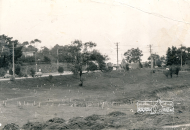 Eltham District Historical Society Inc
Photograph, Alistair Knox Park, Eltham, c.1970, 1970c
... trees and two ponds. Main Road has been duplicated. Bridge Street intersection showing the rock wall on the east side of the original Main Road (Maria Street). Burgoyne's Store and Eltham Uniting Church in distance at centre right and Our Lady Help of Christians at centre left. In February 1968 an unknown person took a series of photos from the Eltham Hotel at Pitt Street heading north along Main Road through the shopping centre to just north of Elsa Court covering the length of the section of Main Road which was duplicated shortly thereafter. Shows the condition ...View from northwest corner showing survey pegs for trees and two ponds. Main Road has been duplicated. Bridge Street intersection showing the rock wall on the east side of the original Main Road (Maria Street). Burgoyne's Store and Eltham Uniting Church in distance at centre right and Our Lady Help of Christians at centre left.In February 1968 an unknown person took a series of photos from the Eltham Hotel at Pitt Street heading north along Main Road through the shopping centre to just north of Elsa Court covering the length of the section of Main Road which was duplicated shortly thereafter. Shows the condition and environment of the streesscape of Main Road, Eltham immediately prior to the duplication between Pitt Street and Elsa Court through the shopping centre. Also shows a number of shops and businesses that operated at that time.Black and white photographduplication, eltham, main road, bridge street, burgoyne's shop, eltham uniting church, our ladys church, maria street -
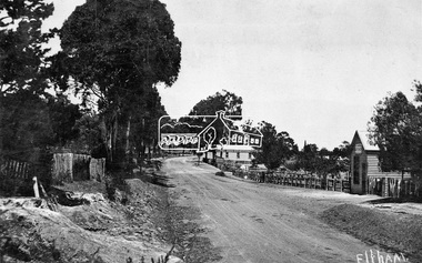 Eltham District Historical Society Inc
Negative - Photograph, Tom Prior, Main Road near Eltham Railway Station, c.1910
... trees in front of the Shillinglaw Cottage facing Main Road. On the eastern (left) side of Main Street is Haley’s Paddock, which was used on occasions for community picnics. Capable of holding 10,000 people, with ample shade and hilly surroundings it was an ideal place for any community gathering such as the State Schools’ Picnic in 1904. Picture dated as c.1910 based on similar picture published in the Weekly Times, Feb. 1912. Kerb and channelling added 1923. Cross Ref: 610 (looking north), 611 (later stage), 613. Same as 705 (though in better condition...trees in front of the Shillinglaw Cottage facing Main Road. On the eastern (left) side of Main Street is Haley’s Paddock, which was used on occasions for community picnics. Capable of holding 10,000 people, with ample shade and hilly surroundings it was an ideal place for any community gathering such as the State Schools’ Picnic in 1904. Picture dated as c.1910 based on similar picture published in the Weekly Times, Feb. 1912. Kerb and channelling added 1923. Cross Ref: 610 (looking north), 611 (later stage), 613. Same as 705 (though in better condition ...View looking south along Main Road, Eltham from near present day Luck Street. On the immediate right is a fence with the words “Hot Water” painted on it followed by William J Capewell’s butcher shop, then the slaughter yard and saleyards with the entrance access to the railway station. Contained within the saleyards facing the street, a small shelter with the name H.H. Clark upon it. Horace Harold Clark was the son of Eltham State School’s first Head Teacher, David George Clark. As well as being a farmer, he was an Estate Agent and conducted auction sales, presumably from this shelter. The large weatherboard building on the corner (opposite present-day Arthur Street) with signs for Summer Drinks and Hot Water painted on the side is Luther and Ada Haley’s General Store and Bakery, built 1902. This was the first building in what is now Eltham’s present shopping town centre. Haley previously ran the General Store and Bakery on the corner of Main Road and York Street until his lease expired and the premises were bought by Mrs Sarah Burgoyne in 1902. The store later was known as Staff's Store. In the distance approximately mid-way between the Butcher shop and the Bakery are the tops of what appears to be two cypress trees, which could well be the trees in front of the Shillinglaw Cottage facing Main Road. On the eastern (left) side of Main Street is Haley’s Paddock, which was used on occasions for community picnics. Capable of holding 10,000 people, with ample shade and hilly surroundings it was an ideal place for any community gathering such as the State Schools’ Picnic in 1904. Picture dated as c.1910 based on similar picture published in the Weekly Times, Feb. 1912. Kerb and channelling added 1923. Cross Ref: 610 (looking north), 611 (later stage), 613. Same as 705 (though in better condition)This photo forms part of a collection of photographs gathered by the Shire of Eltham for their centenary project book,"Pioneers and Painters: 100 years of the Shire of Eltham" by Alan Marshall (1971). The collection of over 500 images is held in partnership between Eltham District Historical Society and Yarra Plenty Regional Library (Eltham Library) and is now formally known as the 'The Shire of Eltham Pioneers Photograph Collection.' It is significant in being the first community sourced collection representing the places and people of the Shire's first one hundred years.Digital image 4 x 5 inch B&W Neg 120 format B&W negative (spare)shire of eltham pioneers photograph collection, eltham, main road, butcher, eltham railway station, railway station, w.j. capewell, baker, eltham town centre, general store, luther haley, reynolds prior collection, shops, haley's paddock, hot water, m.m. clark, sign, summer drinks, eltham sale yards, eltham slaughter yard, staffs general store -
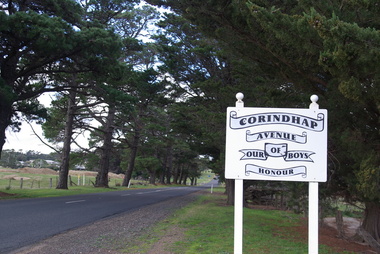 Victorian Interpretive Projects Inc.
Photograph - Colour, Corindhap Avenue of Honour, 2015, 23/08/2015
... A number of colour photographs showing trees from the Corindhap Avenue of Honour. The trees are not in good condition, and one has fallen over. ...(Ballarat Courier, 19th September 1917) Corindhap Corindhap Avenue of Honour Avenue of Honour World War One A number of colour photographs showing trees from the Corindhap Avenue of Honour. The trees are not in good condition, and one has fallen over. ..."The Corindhap Avenue of Honour, located on Colac-Ballarat Road, was planted to commemorate those who served in the First World War. The avenue was planted on the 15th September 1917 as a mark of admiration for the men of Corindhap who had left to fight in the Great War." (Ballarat Courier, 19th September 1917) A number of colour photographs showing trees from the Corindhap Avenue of Honour. The trees are not in good condition, and one has fallen over. corindhap, corindhap avenue of honour, avenue of honour, world war one -
 Greensborough Historical Society
Article, Batman Apple Tree, 11/12/2002
... Details some versions of the history of the 'Batman Apple Tree'. Also the condition and lack of maintenance of the tree in 2002. ...A4 photocopies of 3 articles relating to the condition and origin of the "Batman Apple Tree", located on the eastern bank of the Plenty River, north of Greensborough....Greensborough Historical Society 34A Glenauburn Road Lower Plenty Lower Plenty melbourne Details some versions of the history of the 'Batman Apple Tree'. Also the condition and lack of maintenance of the tree in 2002. ...Details some versions of the history of the 'Batman Apple Tree'. Also the condition and lack of maintenance of the tree in 2002. Highlights Nillumbik Shire's ignorance of the existence of the tree; which is within one kilometre of the Nillumbik Shire Offices.It is possibly the oldest European planted tree in Victoria. It was planted as a young tree in 1841.A4 photocopies of 3 articles relating to the condition and origin of the "Batman Apple Tree", located on the eastern bank of the Plenty River, north of Greensborough.Blue pen annotations on one article.apples, john batman, robert whatmough, frederick nevin flintoff, plenty river, 1841, rome beauty, rymer apples, winter majetin, apollo parkways primary school -
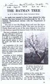 Greensborough Historical Society
Article, Victorian Horticultural Digest, The Batman Tree: by W .A. Rolfe, 1966_04
... Tree in 1966. Author W. A. Rolfe relates his interviews with Greensborough pioneers. Details of condition of Batman Apple Tree in 1966, including its origin. batman apple tree w a rolfe plenty river greensborough Source handwritten on first page. ...This article describes the Batman Apple Tree in 1966. Author W. A. Rolfe relates his interviews with Greensborough pioneers.Details of condition of Batman Apple Tree in 1966, including its origin.Photocopy of article; 4 pages; balck and white illus.Source handwritten on first page.batman apple tree, w a rolfe, plenty river, greensborough -
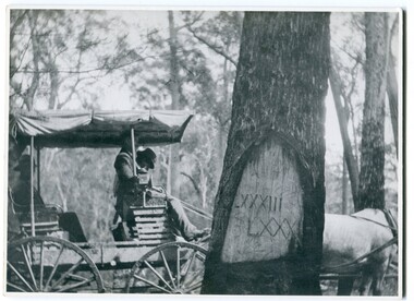 Orbost & District Historical Society
black and white photograph, 1913
... tree. Knowledge of their location, abundance and condition not only provide important insights to past survey practice, but also provide a lasting legacy of a regions land-use history. ...When marking a boundary for a registered plan, a surveyor would place “Reference Marks” with a stated bearing and distance to a boundary corner. These trees were typically marked by cutting the bark of the tree in a shield or blaze. Until July 1886, surveyors were only able to use trees as reference marks to boundary corners. After July 1886 surveyors were able to use “permanent marks” which were either a glass bottle, gas pipe or iron bolt (for homestead surveys only). This photograph shows the reference tree, 83 miles from Marlo via the original surveyed road v ia Sydenham Inlet and Tamboon, south of Mount Drummer to the New South Wales border - now the Princes Highway.This is a pictorial record of an old survet tree. Knowledge of their location, abundance and condition not only provide important insights to past survey practice, but also provide a lasting legacy of a regions land-use history. Old survey trees serve as one of the few remaining physical legacies of early European land settlement history.A large black / white photograph of a horse and buggy pulled up alongside a reference tree which has notches and markings of Roman numerals.on back - " Refernce tree 83 miles from Marlo........to N.S.W. Border"survey-tree reference-tree -
 Flagstaff Hill Maritime Museum and Village
Book - Literary Work, Henry Wardsworth Longfellow, The Poetical Works of Henry Wadsworth Longfellow, (short title on cover is ‘Longfellow’s Poetical Works’), 1877
... condition is still evident. The front and back covers are scored with singed holes approximately 1.5cm diameter, situated about the centre edge of each side and in roughly corresponding positions. These holes may be from an original book-latch or fastening. However they have since been damaged by a hot piercing object, which has blackened the holes and extended the damage into the enclosed pages. The spine of the book features a stylised oak tree...condition is still evident. The front and back covers are scored with singed holes approximately 1.5cm diameter, situated about the centre edge of each side and in roughly corresponding positions. These holes may be from an original book-latch or fastening. However they have since been damaged by a hot piercing object, which has blackened the holes and extended the damage into the enclosed pages. The spine of the book features a stylised oak tree ...This well-produced but water-damaged book of Longfellows Poetry, was part of the former Warrnambool Mechanics Institute Library and Museum collection. The custody of this collection was assumed by Flagstaff Hill Maritime Village in the 1970s. Supporting provenance indicates the book was retrieved from the sea at Loch Ard Gorge soon after the shipwreck of the same name in June 1878. This book was given to the Warrnambool Museum curator Joseph Archibald by its finder, the Warrnambool Standard editor Henry Davis in October 1883. A letter from Mr Davis describing the poignant circumstances of his discovery is also in the Flagstaff Hill collection. A transcript of this letter is displayed next to the book in the Great Circle Gallery at the Maritime Village (reg. no. 2292). The story behind this book prompted Mr Archibald to write to the sole surviving female passenger from the LOCH ARD, Eva Carmichael, asking if the book was hers. Miss Carmichael replied by handwritten letter in January 1884, advising that the volume of poems did not belong to her: “We had a ‘Longfellow’, but our book had a green cover”. This letter is also in the Flagstaff Hill collection (reg. no. 2290.4).The book is rare as it has survived a shipwreck in relatively good condition. It is an example of personal possessions carried by a shipboard passenger in the 1870s. It holds significance for its connection to the renowned poet, Henry Wardsworth Longfellow. The book is important for its probable association with the wreck of the vessel Loch Ard in 1878. The LOCH ARD shipwreck is of State significance and is listed on the Victorian Heritage Register S417. A volume of poetry by Henry Wadsworth Longfellow. It is bound in blue-purple cloth on thick board, with black lettering and curling-vine design, framed by gold border. In the centre of the front cover is a raised smooth-white ellipse with crimped edges, now worn bare but with traces of an original brightly coloured floral design. This white centre of supple leather is also framed by a decorative gold border. The upper case lettering on the front cover reads ‘Longfellow’s Poetical Works’. The edges of the blue material are faded and worn. The pages are corrugated by water damage but their original gold-edged condition is still evident. The front and back covers are scored with singed holes approximately 1.5cm diameter, situated about the centre edge of each side and in roughly corresponding positions. These holes may be from an original book-latch or fastening. However they have since been damaged by a hot piercing object, which has blackened the holes and extended the damage into the enclosed pages. The spine of the book features a stylised oak tree in gold, rising from bared roots to serrated leaves and acorns. The letters “LON[DON]” at the top of the spine and “W.P.NI[MM]O” at the bottom. The book cover has separated from the majority of stitched pages, along with a number of title pages, which are now loosed from the binding. The books condition is fragile from a handling perspective, but stable in terms of further deterioration. ‘Inscribed “Loch Ard June 1 1878” in pencil within ― believed to be a salvage from the shipwreck’ (Mechanics Institute Library auditor, June 1996).warrnambool, shipwrecked-coast, flagstaff-hill, flagstaff-hill-maritime-museum, longfellow’s poems, loch ard, eva carmichael, warrnambool mechanics institute library, warrnambool museum, joseph archibald, henry davis, william p. nimmo, poetry, heny longfellow, henry wadsworth longfellow, poetical works, 1870s, 1877, longfellow’s poetical works -
 Buninyong & District Historical Society
Photograph - Commemorative tree planting at Lal Lal Falls park entrance, Bicentennial tree planting at Lal Lal Falls
... Local family members Colour print in good condition. Bicentennial tree planting at Lal Lal Falls. ...Of significance to local area and identities.Colour print in good condition.bicentennial celebrations., lal lal falls., local family members -
 Ballarat Tramway Museum
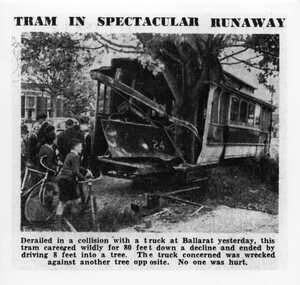
Photograph - Black & White Photograph/s, The Age, 2/12/1941 or 1/12/1941
... tree at the corner of Dana St. on 2/12/1941. Photograph has the heading and caption. Made in March 2000 by the State Library of Victoria from a copy of the newspaper held in their collection. A similar photograph also appeared in the Courier. The Age copy was in better condition...tree at the corner of Dana St. on 2/12/1941. Photograph has the heading and caption. Made in March 2000 by the State Library of Victoria from a copy of the newspaper held in their collection. A similar photograph also appeared in the Courier. The Age copy was in better condition ...Yields information about the accident that involved a tram hitting a tree after being derailed and amount of damage done at the time.Black and white photographic reproduction print of a photograph that appeared in The Age Newspaper on 3/12/1941 of an accident involving Ballarat Tram No. 24 running away following a collision in Drummond St. South and hitting a tree at the corner of Dana St. on 2/12/1941. Photograph has the heading and caption. Made in March 2000 by the State Library of Victoria from a copy of the newspaper held in their collection. A similar photograph also appeared in the Courier. The Age copy was in better condition. Hi Res scan added 25/3/2011. See Reg item 5306 for a different photo, but a very good photo, original print - Wal Jack album and gives date as 1-12-1941.On rear of photograph at the bottom is a sticker - "Reproduction rights reserved - Copied by State Library of Victoria"trams, tramways, accidents, ballarat, drummond st, runaway, tram 24 -
 Ballarat Tramway Museum
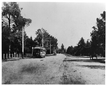
Photograph - Black & White Photograph/s, The Courier Ballarat, 1907
... condition of the roadway at the time. Trams Tramways ESCo Wendouree Parade Ballarat Gardens Tram 18 Black and white photograph of Electric Supply Co. tram No. 18 in Wendouree Parade, Gardens Reserve area, to the west of St Aidans Drive - on present BTM track. Tram travelling east, has poles with old style bracket arms, and white wooden posts on lake side. On right side of photograph under trees ...Yields information about the operation of ESCo trams in Wendouree Parade and the appearance and condition of the roadway at the time.Black and white photograph of Electric Supply Co. tram No. 18 in Wendouree Parade, Gardens Reserve area, to the west of St Aidans Drive - on present BTM track. Tram travelling east, has poles with old style bracket arms, and white wooden posts on lake side. On right side of photograph under trees is a horse drawn cart. From the Ballarat Courier, Christmas supplement of 4-12-1907. Photo features also in postcard - Reg Item 3138. Copy 2 - added 28/7/2007 - from Alan Bradley's collection of photographs, to depot 5/2007.trams, tramways, esco, wendouree parade, ballarat, gardens , tram 18