
Showing 7 items matching "cosgrove street"
-
 Whitehorse Historical Society Inc.
Map, Boronia Road, Vermont, 1970
... ...Cosgrove Street...Boronia Road Vermont Lusk Drive Vermont Morack Road Vermont South Allison Court Vermont Trinian Street Vermont Cosgrove Street Vermont Mawson Court Vermont Aerial photographs Enlargement of aerial photograph of Boronia Road, Vermont. ...Enlargement of aerial photograph of Boronia Road, Vermont. State Aerial Survey 1970 Run 37Enlargement of aerial photograph of Boronia Road, Vermont. State Aerial Survey 1970 Run 37Enlargement of aerial photograph of Boronia Road, Vermont. State Aerial Survey 1970 Run 37boronia road, vermont, lusk drive, vermont, morack road, vermont south, allison court, vermont, trinian street, vermont, cosgrove street, vermont, mawson court, vermont, aerial photographs -
4th/19th Prince of Wales's Light Horse Regiment Unit History Room
Miniature Guidon, 2017
... Cosgrove. AK, MC, (Retd) during a parade held at Puckapunyal on the 26 November 2016. Commanding Officer, Lieutenant Colonel John Molnar Regimental Sergeant Major, Warrant Officer Class 1 Russell Earl The makers of the Guidon, Spear of Fame Pty. Ltd., developed this limited edition miniature in conjunction with the 4th/19th Prince of Wales's Light Horse Regiment for all members past and present to commemorate this occaison Certified by (signature) 62/250 Spear of Fame Pty Ltd 6 King Street, Blackburn. ...Cosgrove. AK, MC, (Retd) during a parade held at Puckapunyal on the 26 November 2016. Commanding Officer, Lieutenant Colonel John Molnar Regimental Sergeant Major, Warrant Officer Class 1 Russell Earl The makers of the Guidon, Spear of Fame Pty. Ltd., developed this limited edition miniature in conjunction with the 4th/19th Prince of Wales's Light Horse Regiment for all members past and present to commemorate this occaison Certified by (signature) 62/250 Spear of Fame Pty Ltd 6 King Street, Blackburn. ...See inscriptionSee inscriptionFramed miniature guidon of the 4th/19th Prince of Wales's Light Horse Regiment. Wood frame with glass front.Certificate on back of frame - "On the 10 October 2006, Lieutenant General P.F. Leahy, AO, then Chief of the Army, authorised the commencement of work for the procurement of a new Guidon for the 4th/19th Prince of Wales's Light Horse Regiment. This new Guidon is historically significant being be (sic) the first single Guidon for a linked unit of the Australian Army. The Guidon proudly shows the unit Colour Patches, Battle and Theatre Honours of: 4th Light Horse Regiment 8th Light Horse Regiment 13th Light Horse Regiment 17th Light Horse Regiment 19th Light Horse Regiment 20th Light Horse Regiment 2nd/8th Armoured Regiment 2nd/4th Armoured Regiment The Guidon was formally presented to the Regiment by His Excellency, General the Honourable Sir Peter Cosgrove. AK, MC, (Retd) during a parade held at Puckapunyal on the 26 November 2016. Commanding Officer, Lieutenant Colonel John Molnar Regimental Sergeant Major, Warrant Officer Class 1 Russell Earl The makers of the Guidon, Spear of Fame Pty. Ltd., developed this limited edition miniature in conjunction with the 4th/19th Prince of Wales's Light Horse Regiment for all members past and present to commemorate this occaison Certified by (signature) 62/250 Spear of Fame Pty Ltd 6 King Street, Blackburn. Ph 03 98771111 -
 Bendigo Historical Society Inc.
Photograph - DRESHER JEWELLER: BRIDGE ST
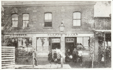
... Cosgrove. After Phillip died his son John Thomas (1873-1919) took over the business. John Thomas was also a watchman for the fire brigade. ORGANIZATION Business dresher jeweller globe hotel re location: J. Lerk 26.11.1999 ' Globe was in Mitchell Street ...Phillip Dresher (1823-1906), was born in Germany and emigrated to Ireland before coming to Australia in 1852. He was married to Margaret Cosgrove. After Phillip died his son John Thomas (1873-1919) took over the business. John Thomas was also a watchman for the fire brigade.black and white photograph. Part of commercial streetscape, Level shop front, upper residential. Dresher Watchmaker Jeweller, Globe Hotel, R. hand verandah, shop not identified. Two trees, paved footpath, bench seat, small child by Dresher window. Gas light outside bar, twin doors to bar,unknown - reprintorganization, business, dresher jeweller, globe hotel, re location: j. lerk, 26.11.1999 ' globe was in mitchell street near wills street' d. walker 5.11 1999 'suggest dresher, jeweller, bridge street, bendigo close to hibernia hotel. -
 Alfred Hospital Nurses League - Nursing History Collection
Book, St John Ambulance Association, St John Ambulance Association hints and helps for home nursing and hygiene, 1908
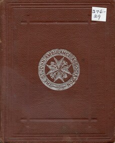
... STREET/BEECHWORTH' Book with dark tan leather cover. The cover has embossed margins. In the centre of the front cover is the badge of 'The St John Ambulance Association'. Theses words are written in a circular margin around a maltese cross, with a line and unicorn alternating in the spaces between the arms [stamped in silver] St John Ambulance Association hints and helps for home nursing and hygiene Book Book St John Ambulance Association E. MacDowel Cosgrove ...A syllabus of lectures to women on home nursing and hygiene contemporary to 1908Book with dark tan leather cover. The cover has embossed margins. In the centre of the front cover is the badge of 'The St John Ambulance Association'. Theses words are written in a circular margin around a maltese cross, with a line and unicorn alternating in the spaces between the arms [stamped in silver]non-fictionA syllabus of lectures to women on home nursing and hygiene contemporary to 1908nursing, hygiene, first aid -
Glen Eira Historical Society
Book - Local Government Act First Report of the Assistant Commissioner of Roads and Bridges
... F. the Honourable Caulfield Moorabbin Road Districts Point Nepean Road Nepean Highway Dandenong Road Princes Highway Brown Edwin Osher Joseph Cosgrove John Ferres John Roads and Bridges Offices Caulfield Roads District Moorabbin Roads District Road Construction and Maintenance Roads and Streets Acts of Parliament Book Local Government Act First Report of the Assistant Commissioner of Roads and Bridges ...This file contains 1 item: 1/The Local Government Act, First Report of the Assistant Commissioner of Roads and Bridges, printed by order of the Victorian Legislative Assembly on 08/03/1865. The document is the first annual report of John Steavenson, Assistant Commissioner of Roads and Bridges under s330 of the Local Government Act no. 176 (1863), and relates to transactions which took place from 02/09/1863 to 31/12/1864. The report outlines operations carried out by the Department of Roads and Bridges in this period. In the Glen Eira area this includes: separating electoral subdivisions of single districts (Moorabbin), adding detached portions of territory to road districts and shires (Caulfield), appointing of and altering in polling places, appointing of polling places for ridings of shires and subdivisions of road districts (Moorabbin), preparing and transmitting of forms of books also of pro forma accounts for guidance of local bodies in keeping their accounts, appointment of main roads, construction of a main road, ‘Dandenong’, in the Caulfield and Gardiner districts, proclaiming of Common Toll Roads, names of and security given by Managers of Common Toll Roads. The report also gives some information about the Shire of Caulfield, which contained 24 road districts and 340 rate payers in 8¼ square miles, and the Shire of Moorabbin, which contained 62 road districts and 713 rate payers in 30 square miles.local government act, assistant commissioner of roads and bridges, legislative council, caulfield historical soceity, steavenson john, sullivan j. f. the honourable, caulfield, moorabbin, road districts, point nepean road, nepean highway, dandenong road, princes highway, brown edwin, osher joseph, cosgrove john, ferres john, roads and bridges offices, caulfield roads district, moorabbin roads district, road construction and maintenance, roads and streets, acts of parliament -
 Bacchus Marsh & District Historical Society
Map, 'Map of Darley' circa 1877-1897
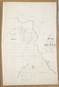
... Street location suggest the map is dated between 1877 and 1897. Landholders names can be seen on some of the allotments of land marked in this map, including the names Clifton, Cosgrove, O'Hagan, McFarlane, Nagle, O'Hagan, Simpson and Vallence....Street location suggest the map is dated between 1877 and 1897. Landholders names can be seen on some of the allotments of land marked in this map, including the names Clifton, Cosgrove, O'Hagan, McFarlane, Nagle, O'Hagan, Simpson and Vallence. ...This map shows the early laid out streets and roads for the village of Darley and the main roads and streets in the central area of the township of Bacchus Marsh. The date of the map is not known. Landmarks indicated on the map including the Anglican Church in Church Street (Gisborne Road), opposite the Presbyterian Church, and the Baptist Church at its pre-1898 Main Street location suggest the map is dated between 1877 and 1897. Landholders names can be seen on some of the allotments of land marked in this map, including the names Clifton, Cosgrove, O'Hagan, McFarlane, Nagle, O'Hagan, Simpson and Vallence.A single page paper map showing the village of Darley and the township of Bacchus Marsh. Scale 10 chains to 1 inch. The map is pasted into a bound volume containing 76 maps or plans in total. High resolution digital image stored on BMDHS computer network. darley victoria maps, bacchus marsh victoria maps -
 Bacchus Marsh & District Historical Society
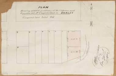
Map, Plan showing relative positions of the Gisborne road formation and Mr. Cosgrove's land in Darley. 1907
... The portion of land referred to as 'Cosgroves' in this plan is located close to the present day Darley Park Recreation Park in Darley, near Bacchus Marsh. The land indicated appears to be close to the corner of Grey Street and Gisborne Road. ...The portion of land referred to as 'Cosgroves' in this plan is located close to the present day Darley Park Recreation Park in Darley, near Bacchus Marsh. The land indicated appears to be close to the corner of Grey Street and Gisborne Road. ...No background information about the roadworks referred to in this plan has been found. The portion of land referred to as 'Cosgroves' in this plan is located close to the present day Darley Park Recreation Park in Darley, near Bacchus Marsh. The land indicated appears to be close to the corner of Grey Street and Gisborne Road. James Cosgrove who died in 1923 aged 65 owned a farm of 52 acres in this area of Darley.Single page map showing a proposed deviation of the Gisborne road in Darley and its position relative to land owned by Mr. Cosgrove. The land owned by Cosgrove is shaded in pink. No scale indicated. Part of a set of maps which are pasted into a bound volume containing 76 maps or plans in total. High resolution digital image stored on BMDHS computer network. Signature (illegible), Eng, Bac Marsh Shire, 30/9/07bacchus marsh roads and streets, darley victoria maps
