Showing 13 items matching "cowes 1950s"
-
 Phillip Island and District Historical Society Inc.
Postcard, Antique postcards of Phillip Island
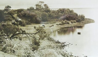
... ...Cowes 1950s...Historical Speke genester house newhaven Lover's Walk Cowes Baths Summerland Beach San Remo pier Cowes beach Aerial photo Cowes 1950s Bridge 1940 san remo Shell Tea Rooms SS Genista Estelle Star Churchill Island Isle of Wight Hotel lover's walk cowes A series of old sepia, black & white, coloured postcards, Rose, Robb brothers, Photo shop Series, Victorian Railways series, Valentines, Hislop, Punch, Airspy of Phillip Island and San Remo scenes. ...Photos were taken from the Facebook page " Antique Post Cards". Permission was obtained form the administrator to use these.HistoricalA series of old sepia, black & white, coloured postcards, Rose, Robb brothers, Photo shop Series, Victorian Railways series, Valentines, Hislop, Punch, Airspy of Phillip Island and San Remo scenes.speke, genester house, newhaven, lover's walk, cowes baths, summerland beach, san remo pier, cowes beach, aerial photo, cowes 1950s, bridge 1940, san remo, shell tea rooms, ss genista, estelle star, churchill island, isle of wight hotel, lover's walk cowes -
 Phillip Island and District Historical Society Inc.
Photograph, 1940's
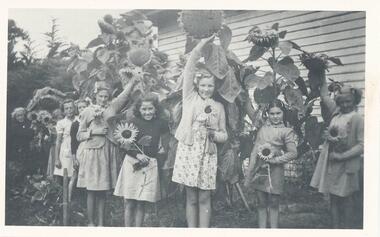
... Black & White photograph of 9 schoolgirls with sunflowers of various sizes - possibly at the Cowes Primary School in 1950s...Phillip Island and District Historical Society Inc. phillip-island-and-the-bass-coast One of a collection of 10 photographs donated by June Robilliard nee Barton schoolgirls cowes primary school june robilliard Black & White photograph of 9 schoolgirls with sunflowers of various sizes - possibly at the Cowes Primary School in 1950s Photograph Photograph ...One of a collection of 10 photographs donated by June Robilliard nee BartonBlack & White photograph of 9 schoolgirls with sunflowers of various sizes - possibly at the Cowes Primary School in 1950sschoolgirls, cowes primary school, june robilliard -
 Phillip Island and District Historical Society Inc.
Photograph, 1940's
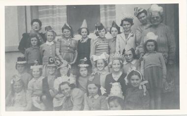
... One of a collection of 10 photographs donated by June Robilliard nee Barton, who attended Cowes State School in the 1950s....Phillip Island and District Historical Society Inc. phillip-island-and-the-bass-coast One of a collection of 10 photographs donated by June Robilliard nee Barton, who attended Cowes State School in the 1950s. schoolgirls cowes primary school school teachers june robilliard Black & White photograph of schoolgirls and four adults wearing party hats - possibly the Cowes Primary School Photograph Photograph ...One of a collection of 10 photographs donated by June Robilliard nee Barton, who attended Cowes State School in the 1950s.Black & White photograph of schoolgirls and four adults wearing party hats - possibly the Cowes Primary Schoolschoolgirls, cowes primary school, school teachers, june robilliard -
 Phillip Island and District Historical Society Inc.
Photograph, circa 1940
... Bayview Guesthouse burn down in 1950s. local history photography photographs slides film aerial view of cowes black & white photograph foreshore jetty Valentine Series (rest cut short) L shaped Jetty, left, Jetty Shed at end. ...Commercially available print made approx 1940s. Bayview Guesthouse burn down in 1950s.L shaped Jetty, left, Jetty Shed at end. Large trees along beach front. Thompson Avenue middle showing most buildings on right. Bayview Guesthouse in foreground right.Valentine Series (rest cut short)local history, photography, photographs, slides, film, aerial view of cowes, black & white photograph, foreshore, jetty -
Phillip Island and District Historical Society Inc.
Photograph, circa 1940
... Bayview Guesthouse (lower right foreshore) was burnt down in 1950s. local history photography photographs slides film aerial views of cowes phillip island black & white photograph aerial views cowes Aerial view of Cowes Phillip Island No. 147 Jetty diagonally lower left - township in foreground - open paddocks in background. ...Commercially printed approx 1940s. Bayview Guesthouse (lower right foreshore) was burnt down in 1950s.Jetty diagonally lower left - township in foreground - open paddocks in background. Thompson Avenue & Cypress trees lower middle to upper right. Taken approx 1940sAerial view of Cowes Phillip Island No. 147local history, photography, photographs, slides, film, aerial views of cowes, phillip island, black & white photograph, aerial views cowes -
 Phillip Island and District Historical Society Inc.
Postcard, Souvenir of Cowes, Phillip Island
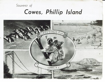
... 1950s. Collected by Lillian Atkinson on holiday in 1959. Historical Postcards Lillian Atkinson Phillip Island Car Racing motor car racing Cowes West beach Cowes Jan. 1959 Picture postcard set. 10 black & white postcards of Island attractions on fold out sheet in attached envelope. ...Typical tourist souvenir and photographs of the 1950s. Collected by Lillian Atkinson on holiday in 1959.HistoricalPicture postcard set. 10 black & white postcards of Island attractions on fold out sheet in attached envelope. Contains a brief explanation of tourist attractions on Phillip Island. Produced by Rose Stereograph Co., Armadale, Victoria. Several postcards have writing in blue pen under them. Cowes Jan. 1959postcards, lillian atkinson, phillip island car racing, motor car racing, cowes west beach -
 Phillip Island and District Historical Society Inc.
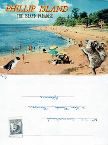
Postcard, Phillip Island - The Island Paradise, Late 1950s
... 1950s to early 1960s from the stamp on the envelope. Penguin Parade had few buildings and basic facilities. Historical Tourism Coloured Postcard Summerland Beach Penguin Parade The Isle of Wight Hotel Cowes Phillip Island Cowes Beach Published by Nucolorvue Productions Pty.Ltd. ...Tourist souvenir postcards from late 1950s to early 1960s from the stamp on the envelope. Penguin Parade had few buildings and basic facilities.HistoricalA coloured postcard foldout folder containing 12 coloured photos of island landscapes and animalsPublished by Nucolorvue Productions Pty.Ltd. Mentone Melbournetourism, coloured postcard, summerland beach, penguin parade, the isle of wight hotel cowes phillip island, cowes beach -
 Eltham District Historical Society Inc
Photograph, George Coop, Carrucan's Dairy on Dalton Street, Eltham, c.1969, 1969
... Tim Erickson, (a nephew to Betty Erickson, nee Carrucan) reacalled (9 May 2025): the bottom front paddock ran from MeteryRoad to Mount Pleasant Road The brick dairy from 1thje 1950s had 10-15 milking cow , Jersey and Guernsey6 and the used to send the cream to Eltham Dairy The garage when Tim was a child used to house a couple of sulkies The laundry was a local home built job The small house built late 1940s for Betty Carrucan for her family The small orchard grew Quince, Apple and Plum The main block was the upper paddock Cypress trees remain present as of 2025 Originally 2 buildings but a third was added in the early 1900s for a kitchen and dining...Tim Erickson, (a nephew to Betty Erickson, nee Carrucan) reacalled (9 May 2025): the bottom front paddock ran from MeteryRoad to Mount Pleasant Road The brick dairy from 1thje 1950s had 10-15 milking cow , Jersey and Guernsey6 and the used to send the cream to Eltham Dairy The garage when Tim was a child used to house a couple of sulkies The laundry was a local home built job The small house built late 1940s for Betty Carrucan for her family The small orchard grew Quince, Apple and Plum The main block was the upper paddock Cypress trees remain present as of 2025 Originally 2 buildings but a third was added in the early 1900s for a kitchen and dining Bible Street, Carrucan dairy, Carrucan home, Dalton Street, Eltham, Mount Pleasant Road Digital TIFF file Scan of 35mm Ilford HP4 black and white transparency Carrucan's Dairy on Dalton Street, Eltham, c.1969 Photograph George Coop ...Viewed from intersection of Mount Pleasant Road and Metery Road looking northwest. The dairy is in the foreground situated on Dalton Street. An unmade Bible Street can be seen running down the hill at the left to intersect with Dalton Street. Dalton Street runs from left to right between the dairy and the Carrucan family home opposite located on the southeast corner of Bible and Dalton streets. Doug Orford recalls the dairy was at a slight angle to Dalton Street. Tim Erickson, (a nephew to Betty Erickson, nee Carrucan) reacalled (9 May 2025): the bottom front paddock ran from MeteryRoad to Mount Pleasant Road The brick dairy from 1thje 1950s had 10-15 milking cow , Jersey and Guernsey6 and the used to send the cream to Eltham Dairy The garage when Tim was a child used to house a couple of sulkies The laundry was a local home built job The small house built late 1940s for Betty Carrucan for her family The small orchard grew Quince, Apple and Plum The main block was the upper paddock Cypress trees remain present as of 2025 Originally 2 buildings but a third was added in the early 1900s for a kitchen and diningDigital TIFF file Scan of 35mm Ilford HP4 black and white transparencybible street, carrucan dairy, carrucan home, dalton street, eltham, mount pleasant road -
 Orbost & District Historical Society
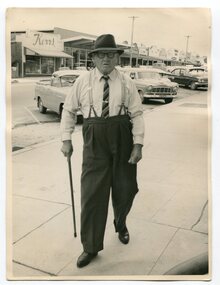
Photograph - Photograph off Albert Trewin
... Then they milked cows, planted maize, had pigs, drove the pigs to Bairnsdale or to Waygara (c. 1915 when the train reached Waygara) on a buggy track through the bush. Pigs went to Dandenong Bacon Factory where they were processed into Dandy Ham. This photograph appears to be c.1950s...Then they milked cows, planted maize, had pigs, drove the pigs to Bairnsdale or to Waygara (c. 1915 when the train reached Waygara) on a buggy track through the bush. Pigs went to Dandenong Bacon Factory where they were processed into Dandy Ham. This photograph appears to be c.1950s ...Albert (Abby) Trewin (b.21.03.1876 d. 01.07.1970) was part of the Trewin family who were early settlers at Jarrahmond near Orbost. Albert was born at Kingston near Ballarat, shifted to Jarrahmond where the house was called "Hillview", located 3 miles from Orbost on the B Road. The Trewin selection at Jarrahmond had many big trees on it and because these looked a bit like Jarrah trees from Western Australia, they names their property Jarrahmond (which became the district location and the name of Jarrahmond School). He cleared the land with bullocks, horses, crosscut saws, burned the stumps, burying some logs which were too big to burn. Then they milked cows, planted maize, had pigs, drove the pigs to Bairnsdale or to Waygara (c. 1915 when the train reached Waygara) on a buggy track through the bush. Pigs went to Dandenong Bacon Factory where they were processed into Dandy Ham. This photograph appears to be c.1950s - 1960s.A photograph of one of Jarrahmond's earliest settlers.B/W photograph of a man walking along a footpath. He is wearing a hat and has a walking stick in his right hand. He is wearing braces, white long-sleeved shirt, striped tie, glasses, polished black shoes. Behind him are vehicles and buildings (shops). jarrahmond, farming -
 Marysville & District Historical Society
Ephemera (item) - Poem, WE'VE BOUGHT A JOINT IN BURWOOD IT SITS UPON A HILL, Unknown
... A type written comedic poem written by an unknown author about a cow the Darmody's purchased. Jim and Muriel Darmody owned The Marysville Hotel in the 1950s....A type written comedic poem written by an unknown author about a cow the Darmody's purchased. Jim and Muriel Darmody owned The Marysville Hotel in the 1950s....Marysville & District Historical Society 39 Darwin Street Marysville yarra-valley-and-the-dandenong-ranges A type written comedic poem written by an unknown author about a cow the Darmody's purchased. Jim and Muriel Darmody owned The Marysville Hotel in the 1950s. ...A type written comedic poem written by an unknown author about a cow the Darmody's purchased. Jim and Muriel Darmody owned The Marysville Hotel in the 1950s.A type written comedic poem written by an unknown author about a cow the Darmody's purchased. Jim and Muriel Darmody owned The Marysville Hotel in the 1950s.victoria, australia, keppel hotel, keppel's australian hotel, australian hotel, keppel family, maurice john keppel, accommodation, marysville hotel, hotel marysville, marysville hotel motel, marysville, keppels hotel motel, muriel darmody, jim darmody, poem -
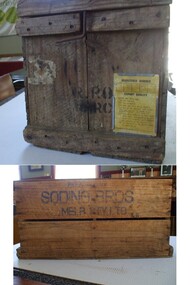 Harcourt Valley Heritage & Tourist Centre
Egg box, Circa 1960
... 1950s and 1960s many folk in Harcourt conducted poultry farms of varying sizes, utilising boxes of this type. Harcourt thus became a major producer in the Victorian egg industry. Smaller-scale operations were wiped out when the producers were expected to hold eggs in a coolroom. Illustrates one aspect of the multi-faceted streams of income open to local landowners who conducted an orchard, bred pigs, raised fowls for egg production and kept a few cows ...Used by Ron Robins for delivery of eggs (30 dozen per box) to the agents for the Victorian Egg Marketing Board, in this case Soding Bros , succeeded by Sympag and Crystal Ice Works, initially to premises at 64 Mostyn St, Castlemaine (now Saffs Cafe) later to premises at south-west corner of Calder Hwy and Lockwood Road, Kangaroo Flat (now Aldi supermarket).Made obsolete by use of trolleys holding 360 dozen eggs, handled into refrigerated transport by a hydraulic tailgate loader. Original label specifies that the eggs are ; infertile; unwashed; not damp cleaned; of specified yolk colour; held at 55 to 60 degrees Fahrenheit and delivered within 96 hours of lay.Significance During the 1950s and 1960s many folk in Harcourt conducted poultry farms of varying sizes, utilising boxes of this type. Harcourt thus became a major producer in the Victorian egg industry. Smaller-scale operations were wiped out when the producers were expected to hold eggs in a coolroom.Illustrates one aspect of the multi-faceted streams of income open to local landowners who conducted an orchard, bred pigs, raised fowls for egg production and kept a few cows for cream production. Wooden box with detachable wooden lid, two internal compartments and a galvanised holder for a card on which the producer has signed a declaration as the condition and handling of the contents.Property of Soding Bros, Melbourne -
 Kew Historical Society Inc
Album - Photographs of heritage sites in Victoria, Eva Grant, 1964-66
... 1950s and 1960s. Particular structures photographed in this album include: Barnawatha (Vic.) - The Hermitage | Beveridge (Vic.) - Stone cottage where Ned Kelly was born. | Brighton - St Andrew’s Church graveyard. | Chiltern (Vic.) - lake view [missing] | Cowes (Vic.) - ‘Broadwater’ [originally home of Henty-Wilson family], demolished 1965; Bell of the Speke wreck; Edward’s tree. | Euroa (Vic.) - Habbies Howe | Fairfield (Vic.) - Dight’s Falls; John Dight. | Fernshawe (Vic.) - Queen Mary tree. | Jolimont (Vic.) - Old railway tunnel linking the first Government House (1964); Sign identifying location of first Government House. | Kew (Vic.) - Cairn at Dight’s Falls; Canoe tree, Bowyer Avenue. | Kyneton - De Grave’s Flour Mill - “C”. | Maldon (Vic.) - Chinese oven; Macarthur’s House; Maldon’s oldest resident; Chinese graves x 2; [Beehive Chimney]. | Marysville (Vic.) - Centenary cairn | Mitcham (Vic.), Mud brick house x 2, Deep Creek Road. | Melbourne (Vic.) - St Paul’s Cathedral [renovation] (1964); Wreckers at Damman’s Corner, cnr Bourke and Collins Streets (1964); Princess Gate project x 2 (1964); Colonial Storekeeper’s building on cnr King and Bourke Streets (1966); Early observatory 1861-3; the Honey Memorial. | Mt Oberon (Vic.) - [obsolete] radio telephone dish. | Seymour (Vic.) - Habres (sic) House x 3.| Swan Hill (Vic.) - Major Mitchell’s Cairn (12/1964); Headstone of Andrew Beverage AM (12/1964). | Templestowe (Vic.) - Finn’s Hotel. | Thornton (Vic.) - Eildon Station. | Werribee (Vic.) - Chirnside Memorial [Presbyterian] Church; gaslight beside church | Location unknown, but possibly Swan Hill - Brick house; Wooden bullock dray. | Location unknown - Headstone of John Furlonge 1835....1950s and 1960s. Particular structures photographed in this album include: Barnawatha (Vic.) - The Hermitage | Beveridge (Vic.) - Stone cottage where Ned Kelly was born. | Brighton - St Andrew’s Church graveyard. | Chiltern (Vic.) - lake view [missing] | Cowes (Vic.) - ‘Broadwater’ [originally home of Henty-Wilson family], demolished 1965; Bell of the Speke wreck; Edward’s tree. | Euroa (Vic.) - Habbies Howe | Fairfield (Vic.) - Dight’s Falls; John Dight. | Fernshawe (Vic.) - Queen Mary tree. | Jolimont (Vic.) - Old railway tunnel linking the first Government House (1964); Sign identifying location of first Government House. | Kew (Vic.) - Cairn at Dight’s Falls; Canoe tree, Bowyer Avenue. | Kyneton - De Grave’s Flour Mill - “C”. | Maldon (Vic.) - Chinese oven; Macarthur’s House; Maldon’s oldest resident; Chinese graves x 2; [Beehive Chimney]. | Marysville (Vic.) - Centenary cairn | Mitcham (Vic.), Mud brick house x 2, Deep Creek Road. | Melbourne (Vic.) - St Paul’s Cathedral [renovation] (1964); Wreckers at Damman’s Corner, cnr Bourke and Collins Streets (1964); Princess Gate project x 2 (1964); Colonial Storekeeper’s building on cnr King and Bourke Streets (1966); Early observatory 1861-3; the Honey Memorial. | Mt Oberon (Vic.) - [obsolete] radio telephone dish. | Seymour (Vic.) - Habres (sic) House x 3.| Swan Hill (Vic.) - Major Mitchell’s Cairn (12/1964); Headstone of Andrew Beverage AM (12/1964). | Templestowe (Vic.) - Finn’s Hotel. | Thornton (Vic.) - Eildon Station. | Werribee (Vic.) - Chirnside Memorial [Presbyterian] Church; gaslight beside church | Location unknown, but possibly Swan Hill - Brick house; Wooden bullock dray. | Location unknown - Headstone of John Furlonge 1835. ...Eva Grant was a member of the Kew Historical Society. Three albums in the collection were created by her, this one, the third created between 1964 and 1966. They were donated to the Society by her daughter in 2010. Each of the albums includes photographs and newspaper cuttings collected on her travels to historic places in South East Australia in the 1950s and 1960s. Particular structures photographed in this album include: Barnawatha (Vic.) - The Hermitage | Beveridge (Vic.) - Stone cottage where Ned Kelly was born. | Brighton - St Andrew’s Church graveyard. | Chiltern (Vic.) - lake view [missing] | Cowes (Vic.) - ‘Broadwater’ [originally home of Henty-Wilson family], demolished 1965; Bell of the Speke wreck; Edward’s tree. | Euroa (Vic.) - Habbies Howe | Fairfield (Vic.) - Dight’s Falls; John Dight. | Fernshawe (Vic.) - Queen Mary tree. | Jolimont (Vic.) - Old railway tunnel linking the first Government House (1964); Sign identifying location of first Government House. | Kew (Vic.) - Cairn at Dight’s Falls; Canoe tree, Bowyer Avenue. | Kyneton - De Grave’s Flour Mill - “C”. | Maldon (Vic.) - Chinese oven; Macarthur’s House; Maldon’s oldest resident; Chinese graves x 2; [Beehive Chimney]. | Marysville (Vic.) - Centenary cairn | Mitcham (Vic.), Mud brick house x 2, Deep Creek Road. | Melbourne (Vic.) - St Paul’s Cathedral [renovation] (1964); Wreckers at Damman’s Corner, cnr Bourke and Collins Streets (1964); Princess Gate project x 2 (1964); Colonial Storekeeper’s building on cnr King and Bourke Streets (1966); Early observatory 1861-3; the Honey Memorial. | Mt Oberon (Vic.) - [obsolete] radio telephone dish. | Seymour (Vic.) - Habres (sic) House x 3.| Swan Hill (Vic.) - Major Mitchell’s Cairn (12/1964); Headstone of Andrew Beverage AM (12/1964). | Templestowe (Vic.) - Finn’s Hotel. | Thornton (Vic.) - Eildon Station. | Werribee (Vic.) - Chirnside Memorial [Presbyterian] Church; gaslight beside church | Location unknown, but possibly Swan Hill - Brick house; Wooden bullock dray. | Location unknown - Headstone of John Furlonge 1835.Important record of significant heritage properties in Victoria, many of which have since been demolished.30 page spirex bound drawing book including photographs and newspaper articles of historic buildings in Victoria. The front cover has a picture of a steam boat. The cover is encased in plastic. A number items in the album are annotated with written commentary by Eva Grant who compiled the album. Annotations and transcriptions by Eva Grant on most imageseva grant, photograph albums, heritage places - victoria -
 Phillip Island Conservation Society Inc.
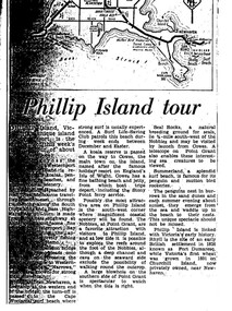
Work on paper - Photocopy of newspaper cutting, "Phillip Island tour", circa 1950s?
... Cowes, the jetty and beach there, and the Nobbies (Point Grant), with views of the Seal Rocks offshore through telescope at the Nobbies. The writer also visited Summerland beach, described as a surf beach, with penguin and mutton bird rookeries. While not specifically referring to the Penguin Parade, the writer says the spectacle of seeing the penguins coming ashore is not to be missed. The brief military colony at Rhyll and the first Victorian 'garden' planted at Churchill Island in 1801 are also mentioned Article is significant because it is an early (1950s ...The article relates the journalist's visit to Phillip Island, starting from Melbourne and describing features along the way, then at San Remo on mainland side of Phillip Island bridge, then Newhaven on the other. Other places visited include the main town of Cowes, the jetty and beach there, and the Nobbies (Point Grant), with views of the Seal Rocks offshore through telescope at the Nobbies. The writer also visited Summerland beach, described as a surf beach, with penguin and mutton bird rookeries. While not specifically referring to the Penguin Parade, the writer says the spectacle of seeing the penguins coming ashore is not to be missed. The brief military colony at Rhyll and the first Victorian 'garden' planted at Churchill Island in 1801 are also mentionedArticle is significant because it is an early (1950s?) tourist guide to Phillip Island's most popular tourist destinations. 3 column text under map of Phillip Island. Black print on white paper. phillip island, newhaven, , westernport, surf beaches phillip island, summerland beach, penguins, mutton birds, the nobbies, point grant, seal rocks, cowes, nobbies blowhole, rhyll, churchill island, nobbies telescope