Showing 12 items matching "craigieburn"
-
 Broadmeadows Historical Society & Museum
Photograph - Aerial Photograph
... ...Craigieburn...Craigieburn is a rapidly growing suburb located approximately 25 km north of Melbourne’s CBD. ...Colour aerial photograph of Craigieburn...Broadmeadows Historical Society & Museum 21 Pearcedale Parade Broadmeadows melbourne Craigieburn is a rapidly growing suburb located approximately 25 km north of Melbourne’s CBD. ...Craigieburn is a rapidly growing suburb located approximately 25 km north of Melbourne’s CBD. Historically, it was a rural area with agricultural roots, but since the late 20th century, it has undergone significant urban development. The transformation accelerated in the 1990s and 2000s, with large-scale residential subdivisions, infrastructure projects, and commercial developments reshaping the landscape. Key historical milestones include: Early Settlement: Originally inhabited by the Wurundjeri people of the Kulin Nation. European Settlement: Began in the mid-1800s, primarily for farming and grazing. Urban Expansion: Post-1970s, Craigieburn saw increasing suburban development, especially after the extension of rail and road infrastructure. Recent Growth: From the 2000s onward, Craigieburn became one of Melbourne’s fastest-growing suburbs, with new estates, schools, and shopping centres.This large colour aerial photograph of Craigieburn holds significant value as a visual record of the suburb’s transformation from a semi-rural landscape to a dynamic urban centre in Melbourne’s northern growth corridor. Captured during a period of rapid development, the image documents the spatial evolution of Craigieburn, including residential expansion, infrastructure projects, and the integration of green spaces and commercial zones. The photograph is historically significant as it reflects the broader patterns of post-2000 suburban growth in Victoria, driven by population pressures, housing demand, and strategic planning initiatives. It provides insight into land use changes, transport connectivity (notably the Hume Highway and Craigieburn railway line), and the emergence of community hubs such as Craigieburn Central. From a cultural heritage perspective, the image contributes to understanding the lived environment of diverse communities who have settled in Craigieburn, including its role in accommodating Melbourne’s multicultural population. It also serves as a reference point for future urban planning, environmental monitoring, and historical comparison. The photograph is an important archival asset for researchers, planners, and local historians, offering a detailed snapshot of a pivotal moment in Craigieburn’s development trajectory.Colour aerial photograph of Craigieburnaerial photograph, craigieburn -
 City of Whittlesea
Photograph (item) - Photographs - Buildings, Summerhill Farm
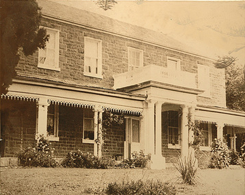
... Summer Hill at Craigieburn...City of Whittlesea 25 Ferres Boulevard South Morang melbourne sherwin family wollert Dr Thomas Wilson Summer Hill at Craigieburn Black & White copy print - stapled to chipboard back Summerhill Farm Photograph Photographs - Buildings ...Summer Hill at Craigieburnsherwin family, wollert, dr thomas wilson -
Hume City Civic Collection
Pamphlet, 2017 Hume City Council Community Grants Presentation, 8 February 2017
... This is the program for the Hume City Council 2017 presentation night for the Community Grants awards held at Craigieburn on 8 February 2017. On the third and fourth pages there is a list of the names of recipients of the grants....Hume City Civic Collection 44 Macedon Street Sunbury melbourne This is the program for the Hume City Council 2017 presentation night for the Community Grants awards held at Craigieburn on 8 February 2017. On the third and fourth pages there is a list of the names of recipients of the grants. ...This is the program for the Hume City Council 2017 presentation night for the Community Grants awards held at Craigieburn on 8 February 2017. On the third and fourth pages there is a list of the names of recipients of the grants.This is a small white and aqua coloured pamphlet. It has black and aqua print also the logo of Hume City Council on the front cover. It is a single fold with writing on all four pages. HUME CITY COUNCIL/2017/COMMUNITY GRANTS/PRESENTATION/8 FEBRUARY 2017hume city council, community grants -
 Sunbury Family History and Heritage Society Inc.
Photograph, School Sports Day
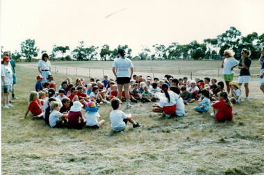
... Bulla Primary School along with Mickleham, Yuroke, Greenvale, Craigieburn and Kal Kallo competed in the completion before some of those towns became suburbs....Bulla Primary School along with Mickleham, Yuroke, Greenvale, Craigieburn and Kal Kallo competed in the completion before some of those towns became suburbs. ...The photograph was taken on a sports day which took place at the Mickleham Sports Ground. Bulla Primary School along with Mickleham, Yuroke, Greenvale, Craigieburn and Kal Kallo competed in the completion before some of those towns became suburbs.This event took place when Bulla and the surrounding towns were still rural settlements.A coloured photograph of children sitting in a circle on the ground in an open field while a teacher is talking to thembulla primary school, mickleham, school sports meetings -
 Sunbury Family History and Heritage Society Inc.
Photograph, Sports Day, c1990s
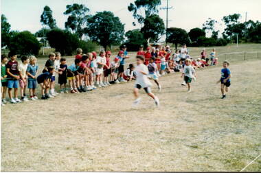
... Bulla School competed with other local small rural schools which included MIckleham, Yuroke, KalKallo, Greenvale and Craigieburn. Most of those towns are now part of suburbia....Bulla School competed with other local small rural schools which included MIckleham, Yuroke, KalKallo, Greenvale and Craigieburn. Most of those towns are now part of suburbia. ...The children were at a district sport's day which took place at the MIckleham sports ground. Bulla School competed with other local small rural schools which included MIckleham, Yuroke, KalKallo, Greenvale and Craigieburn. Most of those towns are now part of suburbia.A coloured photograph of a sport's day with five little boys in a running race and spectators watching.bulla primary school, school sports meetings, mickleham -
 Sunbury Family History and Heritage Society Inc.
Photograph, Pan Pix, Bulla Primary School, 1968
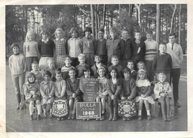
... Other schools competing were Greenvale, Mickleham, Craigieburn, Broadmeadows, Yuroke and Tullamarine. ...Other schools competing were Greenvale, Mickleham, Craigieburn, Broadmeadows, Yuroke and Tullamarine. ...The photograph of the 30 pupils with their teacher was taken in 1968 at the Bulla S.S. No. 46. after they came first in the Greenvale and District School Sports Association. Other schools competing were Greenvale, Mickleham, Craigieburn, Broadmeadows, Yuroke and Tullamarine. In 1968 all these schools were rural schools.When this photograph was taken, Bulla State School was classed as a one-teacher rural school with 30 students in the one room.A non-digital black and white photograph, with a cream border, of 30 students with their teacher. A girl in the centre front row is holding up a sports banner. There is a tree plantation in the background. bulla state school no. 46, sports, district sports associations -
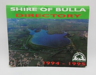 Hume City Civic Collection
Directory, Shire of Bulla Directory, 1994 - 1995
... ...craigieburn...It features details of public services which were available within the area at the time as well as maps of the settlements and some private advewrtisements. shire of bulla directory sunbury bulla attwood hill craigieburn george evans collection A 20 page booklet with an aerial photograph of the Greenvale Dam and surrounding area on the front cover. ...The Directory was published by the former Shire of Bulla in 1994 - 1995 and was issued to residentsa living withing the Shire. It features details of public services which were available within the area at the time as well as maps of the settlements and some private advewrtisements.A 20 page booklet with an aerial photograph of the Greenvale Dam and surrounding area on the front cover. A green strip is along the spine of the booklet with the words 'Shire of Bulla' printed in white and 'Directory' printed in red. '1994 - 1995' is printed in red across the bottom of the front cover and the Shire of Bulla - 'City Living . Country Style' logo is in the bottom RH corner. The back cover features an advertisement for the Roxburgh housing development.shire of bulla, directory, sunbury, bulla, attwood hill, craigieburn, george evans collection -
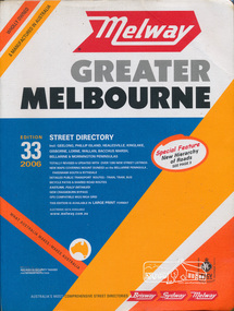 Eltham District Historical Society Inc
Book, Melway Publishing, Melway Greater Melbourne street directory : including Geelong, Phillip Island, Healesville, Kinglake, Gisborne, Lorne, Wallan, Bacchus Marsh Bellarine & Mornington Peninsulas; Edition 33, 2006, 2005
... Eastlink fully detailed new Craigieburn bypass GPS compatible WGS/MGA Grid Special feature: New Hierachy of Roads ...Eastlink fully detailed new Craigieburn bypass GPS compatible WGS/MGA Grid Special feature: New Hierachy of Roads streets,roads,melbourne,map,melway Street directory with plastic cover, coloured maps, 902 pages Melway Greater Melbourne street directory : including Geelong, Phillip Island, Healesville, Kinglake, Gisborne, Lorne, Wallan, Bacchus Marsh Bellarine & Mornington Peninsulas; Edition 33, 2006 Book Melway Publishing ...Edition 33. 2006 Coloured detailed maps accessed by a street or location index. Cover: Totally revised and updated with over 1380 new street listings new maps covering Mount Duneed on the Bellarine Peninsula, Pakenham South and Rythdale. Detailed public transport routes - train, tram, bus, bicycle paths & shared road routes. Eastlink fully detailed new Craigieburn bypass GPS compatible WGS/MGA Grid Special feature: New Hierachy of Roads Street directory with plastic cover, coloured maps, 902 pagesstreets,roads,melbourne,map,melway -
Ballarat Tramway Museum
Sign - Sign - Destination Blinds, Trains, Victorian Rail Suburban Train Destination Blind in Miniature: Williamstown and areas north, south etc
... Place names listed are Altona, Westona, Newport, Laverton, Werribee, Williamstown, Williamstown Pier, Sunshine, St Albans, Sunbury, Deer Park West, Melton, Essendon, Broadmeadows, Craigieburn, Coburg, Cowrie, Upfield, Reservoir. ...Place names listed are Altona, Westona, Newport, Laverton, Werribee, Williamstown, Williamstown Pier, Sunshine, St Albans, Sunbury, Deer Park West, Melton, Essendon, Broadmeadows, Craigieburn, Coburg, Cowrie, Upfield, Reservoir. ...Ron Bridger was an avid collector of items related to transport, predominately Trams. These items include newspaper cuttings, pamphlets, reports, timetables, fares prices plus special items relating to events. Items from Melbourne and regional Victoria, interstate - Adelaide and Sydney, plus overseas, make up this collection. A suburban train destination blind in miniature. Place names indicate the western and northern suburbs that the train travels to. Place names listed are Altona, Westona, Newport, Laverton, Werribee, Williamstown, Williamstown Pier, Sunshine, St Albans, Sunbury, Deer Park West, Melton, Essendon, Broadmeadows, Craigieburn, Coburg, Cowrie, Upfield, Reservoir. Blind also indicates Show Special and Race Special.`List of names on black paper with white print.Place names - stationstrain destination blinds, miniature, railway stations, reservoir, upfield, cowrie, coburgcraigieburn, broadmeadows, essendon, melton, deer park west, sunbury, st albans, sunshine, williamstown pier, werribee, laverton, williamstown, newpoort, westona, altona, newport workshops, race special, show special, special, ron bridger collection -
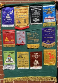 Sunshine and District Historical Society Incorporated
Memorabilia - Sunshine Apex Banners
... Wollongong, Keilor, Craigieburn, Melbourne, Tamar, Holbrook, Melton, Coburb, Ballarat, Association APEX Clubs Australia Zone 1|2129.02 - Association APEX Clubs Australia Zone 8, Cloncurry, The 1986 APEX Australia Scheme Robert Stolz Music Scholarship, Malvern, Collinsvile, Hoppers Crossing, Ararat, Albany, Donald, Cot Death 1979-80 National Services Scheme, Sunshine|2129.03 - Tullamarine, Gold Coast, Sunshine, Collie, Surfers Paradise, Association APEX Clubs Australia Zone 5, Inverloch, Frenchs Forest, Bendigo, Drouin, Shepparton, Geelong, Sunshine, MacKay West, Werribee, moura, Sunbury, Alice Springs, Caringbah, Albury, Croydon, West Townsville, Sunshine, Blacktown, Knox|2129.04 - Sunshine, The Association of Round Tables, Round Table No 7 Tai Ping Hong Kong, Coulsdon & Purley Round Table 67, Naracoorte John McGorm National President Zone 1 1981 - 1982, Williamstown, Barwon - Geelong, Mount Druitt, Narrandera, Ocean Grove Zone 1 President David Webb, Christchurch, Deer Park, Casterton Zone 1 President Peter Sandow, Kaniva, Morden, Mount Gambier, Woy Woy|2129.05 - Dandenong, Springvale, Murwillumbah, Rockingham, Templestowe, Healesville, Port Moresby, Armadale, Huon Gulf, Johnstone River, Sunbury, Doncaster|2129.06 - Round Table Barberton, Thionville, Swellendam, Salisbury Suburbs Rhodesia, Blenheim Round Table, Algoa, Bullawayo Round Table, Rendsburg, Round Table Antwerpen, Umtalia, Round Table Hong Kong, North Yorkshire South Durham|2129.07 - Round Table Deutschland, Terang, World Council Meeting Finland, Round Table New Zealand, Pegasus New Zealand Round Table, Wilmslow District, Atherton 7 Tyldesley Round table, Reading Valley Round Table, Wyong, Pine City Mount Gambier, Tamworth & District Round Table. ...Wollongong, Keilor, Craigieburn, Melbourne, Tamar, Holbrook, Melton, Coburb, Ballarat, Association APEX Clubs Australia Zone 1|2129.02 - Association APEX Clubs Australia Zone 8, Cloncurry, The 1986 APEX Australia Scheme Robert Stolz Music Scholarship, Malvern, Collinsvile, Hoppers Crossing, Ararat, Albany, Donald, Cot Death 1979-80 National Services Scheme, Sunshine|2129.03 - Tullamarine, Gold Coast, Sunshine, Collie, Surfers Paradise, Association APEX Clubs Australia Zone 5, Inverloch, Frenchs Forest, Bendigo, Drouin, Shepparton, Geelong, Sunshine, MacKay West, Werribee, moura, Sunbury, Alice Springs, Caringbah, Albury, Croydon, West Townsville, Sunshine, Blacktown, Knox|2129.04 - Sunshine, The Association of Round Tables, Round Table No 7 Tai Ping Hong Kong, Coulsdon & Purley Round Table 67, Naracoorte John McGorm National President Zone 1 1981 - 1982, Williamstown, Barwon - Geelong, Mount Druitt, Narrandera, Ocean Grove Zone 1 President David Webb, Christchurch, Deer Park, Casterton Zone 1 President Peter Sandow, Kaniva, Morden, Mount Gambier, Woy Woy|2129.05 - Dandenong, Springvale, Murwillumbah, Rockingham, Templestowe, Healesville, Port Moresby, Armadale, Huon Gulf, Johnstone River, Sunbury, Doncaster|2129.06 - Round Table Barberton, Thionville, Swellendam, Salisbury Suburbs Rhodesia, Blenheim Round Table, Algoa, Bullawayo Round Table, Rendsburg, Round Table Antwerpen, Umtalia, Round Table Hong Kong, North Yorkshire South Durham|2129.07 - Round Table Deutschland, Terang, World Council Meeting Finland, Round Table New Zealand, Pegasus New Zealand Round Table, Wilmslow District, Atherton 7 Tyldesley Round table, Reading Valley Round Table, Wyong, Pine City Mount Gambier, Tamworth & District Round Table. ...Collection of 9 cloth banners with pennants of various APEX clubs & events throughout Australia & International attached to the banner2129.01 - Kerrang, Totonto. Wollongong, Keilor, Craigieburn, Melbourne, Tamar, Holbrook, Melton, Coburb, Ballarat, Association APEX Clubs Australia Zone 1|2129.02 - Association APEX Clubs Australia Zone 8, Cloncurry, The 1986 APEX Australia Scheme Robert Stolz Music Scholarship, Malvern, Collinsvile, Hoppers Crossing, Ararat, Albany, Donald, Cot Death 1979-80 National Services Scheme, Sunshine|2129.03 - Tullamarine, Gold Coast, Sunshine, Collie, Surfers Paradise, Association APEX Clubs Australia Zone 5, Inverloch, Frenchs Forest, Bendigo, Drouin, Shepparton, Geelong, Sunshine, MacKay West, Werribee, moura, Sunbury, Alice Springs, Caringbah, Albury, Croydon, West Townsville, Sunshine, Blacktown, Knox|2129.04 - Sunshine, The Association of Round Tables, Round Table No 7 Tai Ping Hong Kong, Coulsdon & Purley Round Table 67, Naracoorte John McGorm National President Zone 1 1981 - 1982, Williamstown, Barwon - Geelong, Mount Druitt, Narrandera, Ocean Grove Zone 1 President David Webb, Christchurch, Deer Park, Casterton Zone 1 President Peter Sandow, Kaniva, Morden, Mount Gambier, Woy Woy|2129.05 - Dandenong, Springvale, Murwillumbah, Rockingham, Templestowe, Healesville, Port Moresby, Armadale, Huon Gulf, Johnstone River, Sunbury, Doncaster|2129.06 - Round Table Barberton, Thionville, Swellendam, Salisbury Suburbs Rhodesia, Blenheim Round Table, Algoa, Bullawayo Round Table, Rendsburg, Round Table Antwerpen, Umtalia, Round Table Hong Kong, North Yorkshire South Durham|2129.07 - Round Table Deutschland, Terang, World Council Meeting Finland, Round Table New Zealand, Pegasus New Zealand Round Table, Wilmslow District, Atherton 7 Tyldesley Round table, Reading Valley Round Table, Wyong, Pine City Mount Gambier, Tamworth & District Round Table. Rovaniemi Finand, Bentleigh|2129.08 - Roma, Warrandyte, Greensborough, Engdine, Chelsea, Cairns, Balga, Korumburra, Innisfall, Round Table Upper Hut New Zealand, Round Table Seisdon, thames New Zealand|2129.09 - Zone 11 President 1978-79, Zone 9 President 1978-79, APEX Australia National President 1978-79. Bendigo's Mine in 79 Zone 10 Convention, Cobram - Barooga Zone Convention 1979, National Association of APEX Clubs of Singapore National President Sylvester Yong 1979-1980, Cot Death 1979-80 National Services Scheme 46th National Convention hosted by Tamar, National service Chairman 1980 - 1981 Bob Gilliver, National Association of APEX Clubs Malaysia Chardran G. Nair National President, Association APEX Clubs Australia Zone 12, Elizabethsunshine apex club, apex -
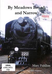 Victorian Railway History Library
Book, Fiddian, Marc, By Meadows Broad and Narrow, 2020
... Victorian Railway History Library 39 St Edmonds Rd Prahran Prahran Railroad construction - Victoria - history Craigieburn - railway - history A history of the Craigieburn railway in the Northern suburbs of Melbourne. index, ill, p.98. ...A history of the Craigieburn railway in the Northern suburbs of Melbourne.index, ill, p.98.non-fictionA history of the Craigieburn railway in the Northern suburbs of Melbourne.railroad construction - victoria - history, craigieburn - railway - history -
 Wodonga & District Historical Society Inc
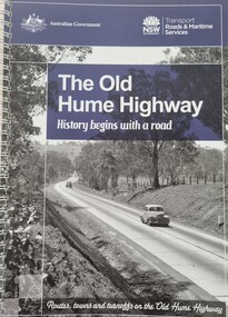
Book - The Old Hume Highway - History begins with a Road, 2014
... In 1961 the first modern freeway-standard, four-lane section was completed in Victoria at Craigieburn. The Hume Highway was also rerouted in Albury to avoid the town centre. ...The Hume Highway was officially named in 1928, when both the New South Wales and Victorian governments agreed to give the unified inland route between Sydney and Melbourne the name, honouring explorer Hamilton Hume who, with William Hovell, first found the overland path in 1824. Much of the original highway followed their overland route wherever the landscape allowed. The road connected many small communities and rural properties, although in many parts was narrow and unsurfaced. Over the following years alterations and some deviations occurred with changing transport needs and heavier traffic loads. One of these deviations was completed in 1933 at Table Top north of Albury between Ettamogah and Mullengandra due to the construction of the Hume Weir which flooded the existing highway. Gradually sections of the road were converted to a dual carriageway. In 1961 the first modern freeway-standard, four-lane section was completed in Victoria at Craigieburn. The Hume Highway was also rerouted in Albury to avoid the town centre. Many major bypasses and duplications in New South Wales were completed throughout the 1980s and 1990s. In 1994 the last section of the Hume Highway in Victoria was duplicated with the completion of the Wangaratta bypass. The Albury-Wodonga bypass was opened in 2007 and in 2013 the final section, the Holbrook Bypass in NSW, was opened to traffic on August 7, completing the full Sydney-Melbourne dual carriageway link. In the course of this gigantic engineering achievement, many small, historic towns throughout Victoria and New South Wales were bypassed and often forgotten by passing commuters in a rush to reach their destination. This publication includes maps and information about the sites and landmarks in these towns. It encourages travellers to venture of the modern highway and rediscover the Old Hume Highway and the stories it holds about out past.A spiral bound volume of 122 pages including maps, photographs and illustrations prepared as a travel guide to the Old Hume Highway. It includes a Foreword by Peter FitzSimons.The Hume Highway was officially named in 1928, when both the New South Wales and Victorian governments agreed to give the unified inland route between Sydney and Melbourne the name, honouring explorer Hamilton Hume who, with William Hovell, first found the overland path in 1824. Much of the original highway followed their overland route wherever the landscape allowed. The road connected many small communities and rural properties, although in many parts was narrow and unsurfaced. Over the following years alterations and some deviations occurred with changing transport needs and heavier traffic loads. One of these deviations was completed in 1933 at Table Top north of Albury between Ettamogah and Mullengandra due to the construction of the Hume Weir which flooded the existing highway. Gradually sections of the road were converted to a dual carriageway. In 1961 the first modern freeway-standard, four-lane section was completed in Victoria at Craigieburn. The Hume Highway was also rerouted in Albury to avoid the town centre. Many major bypasses and duplications in New South Wales were completed throughout the 1980s and 1990s. In 1994 the last section of the Hume Highway in Victoria was duplicated with the completion of the Wangaratta bypass. The Albury-Wodonga bypass was opened in 2007 and in 2013 the final section, the Holbrook Bypass in NSW, was opened to traffic on August 7, completing the full Sydney-Melbourne dual carriageway link. In the course of this gigantic engineering achievement, many small, historic towns throughout Victoria and New South Wales were bypassed and often forgotten by passing commuters in a rush to reach their destination. This publication includes maps and information about the sites and landmarks in these towns. It encourages travellers to venture of the modern highway and rediscover the Old Hume Highway and the stories it holds about out past.old hume highway, hume highway, travel guide hume highway, \