Showing 466 items matching "creek bank"
-
 Eltham District Historical Society Inc
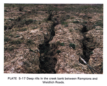
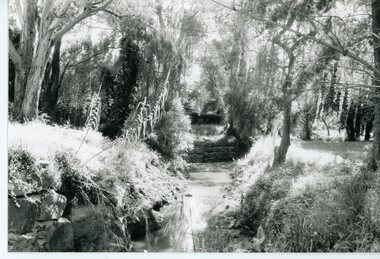
Work on paper (Sub-Item) - Photograph, Deep rills in the creek bank between Rampstons and Weidlich Roads
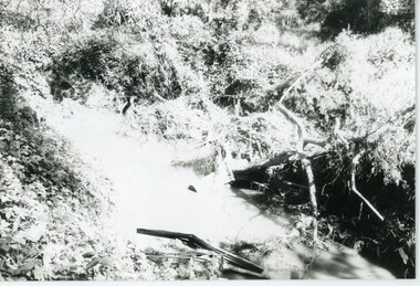
... Deep rills in the creek bank between Rampstons and Weidlich Roads......creek bank...Colour photograph of deep rills in the Diamond Creek bank between Rampstons and Weidlich Roads, Eltham North. ...The shallow channels are cut into the soil by the erosive action of flowing water. eltham creek bank erosion eltham north Image printed on A4 page from 04997 Diamond Creek Basin Study, 1980 Deep rills in the creek bank between Rampstons and Weidlich Roads Work on paper Photograph ...Colour photograph of deep rills in the Diamond Creek bank between Rampstons and Weidlich Roads, Eltham North. The shallow channels are cut into the soil by the erosive action of flowing water.eltham, creek bank, erosion, eltham north -
 Eltham District Historical Society Inc
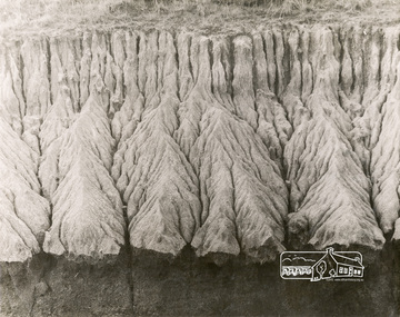
Work on paper (Sub-Item) - Photograph, Bank erosion on Deep Creek, 1976
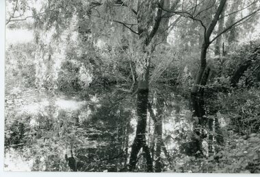
... Bank erosion on Deep Creek...creek...erosion...bank...Colour photograph of creek bank erosion on Deep Creek probably at Arthurs Creek...Eltham District Historical Society Inc 728 Main Rd Eltham melbourne Colour photograph of creek bank erosion on Deep Creek probably at Arthurs Creek arthurs creek Deep creek erosion bank Image printed on A4 page from 04997 Diamond Creek Basin Study, 1980 Bank erosion on Deep Creek Work on paper Photograph ...Colour photograph of creek bank erosion on Deep Creek probably at Arthurs Creekarthurs creek, deep creek, erosion, bank -
 Eltham District Historical Society Inc
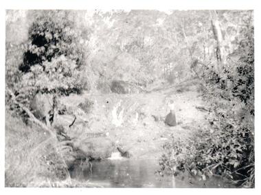
Photograph, George W. Bell, Eroded Creek Banks, Eltham, Susan Street
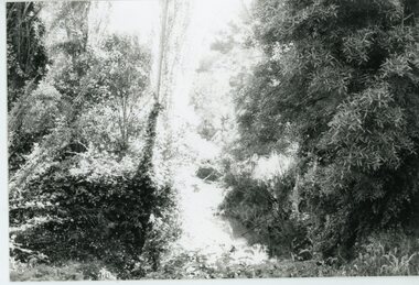
... Black and white photograph of eroded creek banks Diamond Creek near Susan Street Eltham...Eltham District Historical Society Inc 728 Main Rd Eltham melbourne diamond creek eltham susan street erosion george w bell collection Black and white photograph of eroded creek banks Diamond Creek near Susan Street Eltham Eroded Creek Banks, Eltham, Susan Street Photograph George W. ...Black and white photograph of eroded creek banks Diamond Creek near Susan Street Elthamdiamond creek, eltham, susan street, erosion, george w bell collection -
 Hume City Civic Collection
Photograph, c1897
... A woman is standing on a creek bank in a bush setting. Unmounted black and white...During 2000 this was transfered from Mont Park to the Royal Melbourne Hospital. walls w. sunbury asylum walls album george evans collection A woman is standing on a creek bank in a bush setting. Unmounted black and white Photograph W.Walls ...The original photo is part of an album taken by W.Walls, the front page of which is inscribed "The Hill / Sunbury / April 1897". Whilst most of the photos relate to the environs of the asylum, there are others taken around Sunbury and elsewhere. The original album is held as part of the Mental health Library collection. During 2000 this was transfered from Mont Park to the Royal Melbourne Hospital.A woman is standing on a creek bank in a bush setting. Unmounted black and whitewalls, w., sunbury asylum, walls album, george evans collection -
 Stawell Historical Society Inc
Photograph, Dunmunkle Creek where it originally connected to Wimmera River 2017 -- Coloured
... Colour photograph of what looks to be a dry creek bed. Timber on creek bank. ...Just before the Glenorchy Weir (Photo taken 2017) Colour photograph of what looks to be a dry creek bed. Timber on creek bank. Dunmunkle Creek where it originally connected to Wimmera River 2017 -- Coloured Photograph ...Colour Photo of Dunmunkle Creek originally connected to Wimmera River at this point. Just before the Glenorchy Weir. 2017Colour photograph of what looks to be a dry creek bed. Timber on creek bank. Dunmunkle Creek originally connected to Wimmera River at this point. Just before the Glenorchy Weir (Photo taken 2017) water -
 Glenelg Shire Council Cultural Collection
Photograph - Photograph -Bridge and Creek, n.d
... Side view of bridge with wooden railings and supports, taken from bed of creek. Banks of creek eroded. Identifying numbers 7304 a, b...Side view of bridge with wooden railings and supports, taken from bed of creek. Banks of creek eroded. Identifying numbers 7304 a, b Photograph Photograph -Bridge and Creek ...Sourced from Casterton Town Hall (former Shire of Glenelg)Coloured photographs a and b. Side view of bridge with wooden railings and supports, taken from bed of creek. Banks of creek eroded. Identifying numbers 7304 a, b -
 Eltham District Historical Society Inc
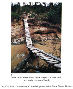
Work on paper (Sub-Item) - Photograph, Home-made footbridge across Diamond Creek, opposite Gum Glade, Eltham
... ...creek bank...Colour photograph of home-made footbridge across the Diamond Creek opposite Gum Glade, Eltham. View from west bank. Note steps cut into bank and undercutting of bank...Eltham District Historical Society Inc 728 Main Rd Eltham melbourne Colour photograph of home-made footbridge across the Diamond Creek opposite Gum Glade, Eltham. View from west bank. Note steps cut into bank and undercutting of bank eltham diamond creek footbridge gum glade creek bank Image printed on A4 page from 04997 Diamond Creek Basin Study, 1980 Home-made footbridge across Diamond Creek, opposite Gum Glade, Eltham Work on paper Photograph ...Colour photograph of home-made footbridge across the Diamond Creek opposite Gum Glade, Eltham. View from west bank. Note steps cut into bank and undercutting of bankeltham, diamond creek, footbridge, gum glade, creek bank -
Glenelg Shire Council Cultural Collection
Photograph - Photograph - Wooden Bridge, n.d
... Wooden bridge, close-up of wooden rails on one side. Erosion of creek banks can be seen in background....Wooden bridge, close-up of wooden rails on one side. Erosion of creek banks can be seen in background. Photograph Photograph - Wooden Bridge ...Sourced from Casterton Town Hall (Former Shire of Glenelg)Coloured photograph. Wooden bridge, close-up of wooden rails on one side. Erosion of creek banks can be seen in background. -
 Whitehorse Historical Society Inc.
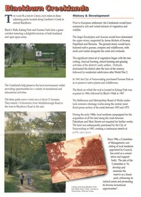
Pamphlet, Blackburn Creeklands, 1/08/1990 12:00:00 AM
... Sympathetic treatment of creek banks and preservation and regeneration of bushland will encourage wildlife, development of wetlands has encouraged water birds, provision of play equipment...Whitehorse Historical Society Inc. 2-10 Deep Creek Road Mitcham melbourne parks and reserves blacks walk kalang park furness park city of nunawading melbourne and metropolitan board of works middleborough road blackburn pakenham street blackburn road gardiners creek laburnum primary school no. 4863 Sympathetic treatment of creek banks and preservation and regeneration of bushland will encourage wildlife Sympathetic treatment of creek banks and preservation and regeneration of bushland will encourage wildlife, development of wetlands has encouraged water birds, provision of play equipment Blackburn Creeklands Pamphlet Pamphlet ...Sympathetic treatment of creek banks and preservation and regeneration of bushland will encourage wildlifeSympathetic treatment of creek banks and preservation and regeneration of bushland will encourage wildlife, development of wetlands has encouraged water birds, provision of play equipmentSympathetic treatment of creek banks and preservation and regeneration of bushland will encourage wildlifeparks and reserves, blacks walk, kalang park, furness park, city of nunawading, melbourne and metropolitan board of works, middleborough road, blackburn, pakenham street, blackburn road, gardiners creek, laburnum primary school no. 4863 -
 Clunes Museum
Photograph, HORNBY STUDIO - CLUNES, FLOOD 1909, August 1909
... TAKEN IN AUGUST 1909 WHEN CREEK WAS IN FLOOD. TREES ON CREEK BANK, MANY PEOPLE ARE STANDING ON BRIDGE....TAKEN IN AUGUST 1909 WHEN CREEK WAS IN FLOOD. TREES ON CREEK BANK, MANY PEOPLE ARE STANDING ON BRIDGE. ...SEPIA PHOTOGRAPH OF SERVICE STREET BRIDGE IN CLUNES. TAKEN IN AUGUST 1909 WHEN CREEK WAS IN FLOOD. TREES ON CREEK BANK, MANY PEOPLE ARE STANDING ON BRIDGE.photographs, bridges, service street bridge -
 Clunes Museum
Photograph
... CLEARING AREA ALONG CREEK - AREA NOW USED AS PICNIC AREA ON CREEK BANK ON BLACKMORE ROAD....CLEARING AREA ALONG CREEK - AREA NOW USED AS PICNIC AREA ON CREEK BANK ON BLACKMORE ROAD. Photograph PHOTOGRAPH ...COLOURED PHOTOGRAPH TAKEN BELOW FORD AT END OF FRASER STREET. CLEARING AREA ALONG CREEK - AREA NOW USED AS PICNIC AREA ON CREEK BANK ON BLACKMORE ROAD.local history, photography, photographs, clunes landscape -
Glenelg Shire Council Cultural Collection
Photograph - Photograph -Bridge, n.d
... Side view of bridge, wooden rails, three wooden supports, taken from bed of creek. Banks of grass, narrow walking track along right side of creek....Side view of bridge, wooden rails, three wooden supports, taken from bed of creek. Banks of grass, narrow walking track along right side of creek. ...Sourced from Casterton Town Hall (former Shire of Glenelg)Coloured photograph. Side view of bridge, wooden rails, three wooden supports, taken from bed of creek. Banks of grass, narrow walking track along right side of creek. -
 Hume City Civic Collection
Photograph
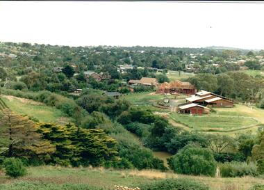
... Housing development spread to the banks of the Jacksons Creek at the east end of the town in the late 1970s....A coloured landscape photograph overlooking the Jacksons Creek and Sunbury township and showing housing development which is taking place on the horse shore bend also known as blueberry island on the opposite creek bank....Hume City Civic Collection 44 Macedon Street Sunbury melbourne Housing development spread to the banks of the Jacksons Creek at the east end of the town in the late 1970s. jacksons creek blueberry island george evans collection A coloured landscape photograph overlooking the Jacksons Creek and Sunbury township and showing housing development which is taking place on the horse shore bend also known as blueberry island on the opposite creek bank. ...Housing development spread to the banks of the Jacksons Creek at the east end of the town in the late 1970s.A coloured landscape photograph overlooking the Jacksons Creek and Sunbury township and showing housing development which is taking place on the horse shore bend also known as blueberry island on the opposite creek bank.jacksons creek, blueberry island, george evans collection -
 Nillumbik Shire Council
Painting: Yvonne BIRCH (nee BALL), Untitled, c.1984
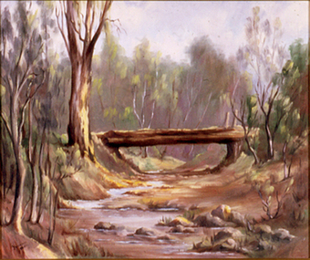
... Trees line the creek banks and a log bridge crosses the creek bed, perhaps built from the local tree timbers....Trees line the creek banks and a log bridge crosses the creek bed, perhaps built from the local tree timbers. ...Oil on canvas board, landscape painting in muted tones of an dry creek bed. Trees line the creek banks and a log bridge crosses the creek bed, perhaps built from the local tree timbers.Lower right, black paint 'Yvonne Ball' -
 Sunshine and District Historical Society Incorporated
Photograph - Lions Club Reserve Kororoit Creek Deer Park Photographs, John Alchin, 2021
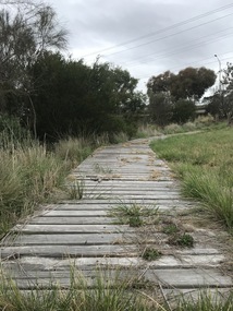
... Situated on the west bank of the Kororoit Creek, it lies directly opposite the Deer Park Hotel, where a swimming hole once enjoyed popularity among the early residents of Deer Park. ...5651.01 - Lions Club Reserve Kororoit Creek West Bank Deer Park 2021 Photo 23.JPG 5651.02 - Lions Club Reserve Kororoit Creek West Bank Deer Park 2021 Photo 17.JPG 5651.03 - Lions Club Reserve Kororoit Creek West Bank Deer Park 2021 Photo 19.JPG 5651.04 - Lions Club Reserve Kororoit Creek West Bank Deer Park 2021 Photo 20.JPG 5651.05 - Lions Club Reserve Kororoit Creek West Bank Deer Park 2021 Photo 21.JPG ...Ballarat Road Deer Park Kororoit Creek Deer Park Lions Club 5651.01 - Lions Club Reserve Kororoit Creek West Bank Deer Park 2021 Photo 23.JPG 5651.02 - Lions Club Reserve Kororoit Creek West Bank Deer Park 2021 Photo 17.JPG 5651.03 - Lions Club Reserve Kororoit Creek West Bank Deer Park 2021 Photo 19.JPG 5651.04 - Lions Club Reserve Kororoit Creek West Bank Deer Park 2021 Photo 20.JPG 5651.05 - Lions Club Reserve Kororoit Creek West Bank Deer Park 2021 Photo 21.JPG Digital Photographs Photograph Lions Club Reserve Kororoit Creek Deer Park Photographs John Alchin ...No formal name has been assigned to this reserve. From research, which is still to be confirmed, it is believed the Deer Park Lions Club installed the infrastructure in the area, which includes the wooden path, table and bench seat, therefore for convenience we will refer to it as the Lions Club Reserve. Situated on the west bank of the Kororoit Creek, it lies directly opposite the Deer Park Hotel, where a swimming hole once enjoyed popularity among the early residents of Deer Park. Unfortunately, as the surrounding areas were developed for residential and industrial requirements, along came pollution that made these holes unsafe to swim in. The use of these holes were discouraged in the mid 1900's and subsequently the local Councils of the district started to provide man made swimming pools such as the ones located in Sunshine and St. Albans. Today, now an almost forgotten location in Deer Park, the water hole provides a tranquil location for visitors to relax and watch the creek slowly flowing past and the birdlife that frequent the area.Water holes along the Kororoit Creek and Maribyrnong River were once used for providing drinking water, relaxation, recreation sport and spots to cool off on the long summer days.5651.01 - Lions Club Reserve Kororoit Creek West Bank Deer Park 2021 Photo 23.JPG 5651.02 - Lions Club Reserve Kororoit Creek West Bank Deer Park 2021 Photo 17.JPG 5651.03 - Lions Club Reserve Kororoit Creek West Bank Deer Park 2021 Photo 19.JPG 5651.04 - Lions Club Reserve Kororoit Creek West Bank Deer Park 2021 Photo 20.JPG 5651.05 - Lions Club Reserve Kororoit Creek West Bank Deer Park 2021 Photo 21.JPG ballarat road, deer park, kororoit creek, deer park lions club -
 Sunbury Family History and Heritage Society Inc.
Photograph, Rosa McCall, Moonee Ponds Creek, 1949
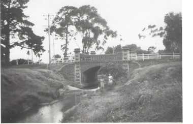
... Pine trees are growing on the creek banks....Pine trees are growing on the creek banks. Moonee Ponds Creek Photograph Rosa McCall ...The single arched stone bridge spans the Moonee Ponds Creek in the former Old Broadmeadows Township, now Westmeadows. The historic bridge is in Fawkner Street, and has a heritage classification. The Moonee Ponds Creek flows from the upper reaches of Greenvale and flows into the Yarra at Docklands.The stone bridge over the Moonee Ponds Creek was erected in 1869 and replaced a less substantial one.A black and white print of a non-digital photograph of a stone single-span bridge spanning a creek. A white post-and-rail fence has been constructed on either side of the bridge. Pine trees are growing on the creek banks.moonee ponds creek, old broadmeadows township, bridges, fawkner street, westmeadows -
 Eltham District Historical Society Inc
Journal - Newsletter, Nillumbik Shire Council, Nillumbik News, July 2009
... ...Diamond Creek Community Bank Stadium...Council Newsletters Nillumbik News Nillumbik Shire Council Shire of Nillumbik Volunteers Diamond Creek Community Bank Stadium Bo Bendsten James Merlino Danielle Green Wattle Glen Steve Herbert MP Helen Coleman kangaroo ground war memorial park Nillumbik Civic Centre Lyla Brown Eltham Leisure Centre Bolton Steet Living & Learning Nillumbik 24 x 21 cm, double stapled, 16 pages Nillumbik News Journal Newsletter Nillumbik Shire Council ...Bi-monthly community newsletter, for July-August 2009, produced by the Shire of Nillumbik and delivered to all households in the Shire. It features stories on volunteers, including first hand accounts of support provided following the Black Saturday bushfires, Diamond Creek multipurpose facility, tennis courts at Wattle Glen, new shelter at Diamond Hills Reserve, Diamond Creek netball courts, funding boost for local sports facilities, hearing loop system for hearing disability, swine flu update, Beanie exhibition (and its story of friendship from NSW), Plant a tree, financial relief for bushfire-affected residents and business owners, sustainable design assessment for bushfire-affected homes, Kangaroo Ground war memorial restorations, upgrade for the Civic Centre, pedestrian lights installed in Bolton Street, Eltham, Council plans, initiatives and events, community calandar, contacts for Councillors.council newsletters, nillumbik news, nillumbik shire council, shire of nillumbik, volunteers, diamond creek community bank stadium, bo bendsten, james merlino, danielle green, wattle glen, steve herbert mp, helen coleman, kangaroo ground war memorial park, nillumbik civic centre, lyla brown, eltham leisure centre, bolton steet, living & learning nillumbik -
 Eltham District Historical Society Inc
Journal - Newsletter, Nillumbik Shire Council, Nillumbik News, September 2011
... ...Diamond Creek Community Bank Stadium...Council Newsletters Nillumbik News Nillumbik Shire Council Shire of Nillumbik Diamond Creek Community Bank Stadium Chris Martin Sarah Hill Bob Mietus Jeanette Davison Jacqueline Felstead Rosemary Cameron Joanne Rockwell Gayle Pohl burgan Living and Learning Nillumbik 24 x 21 cm, double stapled, 28 pages Nillumbik News Journal Newsletter Nillumbik Shire Council ...Quarterly community newsletter, for Spring 2011, produced by the Shire of Nillumbik featuring feature stories on environment sustainability, budget highlights, local festivals, volunteer opportunities, council plans and events, Mayor's report, arts and culture programs, profiles, community calandar, contacts for Councillors, Preparing for summer, including bushfire shelter options or Places of Last resort, managing burgan for fire protection, changes to planning regulations and more.council newsletters, nillumbik news, nillumbik shire council, shire of nillumbik, diamond creek community bank stadium, chris martin, sarah hill, bob mietus, jeanette davison, jacqueline felstead, rosemary cameron, joanne rockwell, gayle pohl, burgan, living and learning nillumbik -
 Clunes Museum
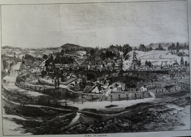
Photograph, CIRCA 1880
... TREE GUARDS AROUND TREES ALONG CREEK BANK, ORIGINAL NAMED TULLAROOP CREEK....TREE GUARDS AROUND TREES ALONG CREEK BANK, ORIGINAL NAMED TULLAROOP CREEK. local history photography photographs clunes township. ...AN ETCHING OF VERY EARLY CLUNES. TREE GUARDS AROUND TREES ALONG CREEK BANK, ORIGINAL NAMED TULLAROOP CREEK.CLUNES TOWNSHIP, CRESWICK CREEK, DOUBLE STORY BUILDINGS AND MINE POPPET HEADS.TOWN OF CLUNESlocal history, photography, photographs, clunes township. -
 Ringwood and District Historical Society
Photograph, Mullum Mullum Creek- 29-10-89
... "Written on back of photograph" Mullum Mullum Creek North bank looking West Near Harrison St...Ringwood and District Historical Society 125A Warrandyte Road Ringwood North melbourne "Written on back of photograph" Mullum Mullum Creek North bank looking West Near Harrison St Black and white photograph Mullum Mullum Creek- 29-10-89. ...Black and white photograph"Written on back of photograph" Mullum Mullum Creek North bank looking West Near Harrison St -
 Ringwood and District Historical Society
Photograph, Mullum Mullum Creek- 29-10-89
... "Written on back of photograph" Mullum Mullum Creek North bank West of Harrison St Rubbish and weeds - view generally to the East...Ringwood and District Historical Society 125A Warrandyte Road Ringwood North melbourne "Written on back of photograph" Mullum Mullum Creek North bank West of Harrison St Rubbish and weeds - view generally to the East Black and white photograph Mullum Mullum Creek- 29-10-89. ...Black and white photograph"Written on back of photograph" Mullum Mullum Creek North bank West of Harrison St Rubbish and weeds - view generally to the East -
 Ringwood and District Historical Society
Photograph, Mullum Mullum Creek- 29-10-89
... "Written on back of photograph" Mullum Mullum Creek North bank. A swampy patch at the rear of a Munro St property. ...Ringwood and District Historical Society 125A Warrandyte Road Ringwood North melbourne "Written on back of photograph" Mullum Mullum Creek North bank. A swampy patch at the rear of a Munro St property. ...Black and white photograph"Written on back of photograph" Mullum Mullum Creek North bank. A swampy patch at the rear of a Munro St property. Not drained or cared for. -
 Ringwood and District Historical Society
Photograph, Mullum Mullum Creek- 29-10-89
... "Written on back of photograph" Mullum Mullum Creek North bank view towards the West. Taken West of Harrison St.. ...Ringwood and District Historical Society 125A Warrandyte Road Ringwood North melbourne "Written on back of photograph" Mullum Mullum Creek North bank view towards the West. Taken West of Harrison St.. ...Black and white photograph"Written on back of photograph" Mullum Mullum Creek North bank view towards the West. Taken West of Harrison St.. Weed infested scrub on banks. -
 Bendigo Historical Society Inc.
Newspaper - JENNY FOLEY COLLECTION: BENDIGO POST OFFICE
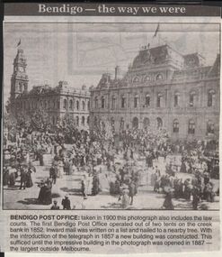
... The first Bendigo Post Office operated out of two tents on the creek bank in 1852. Inward mail was written on a list and nailed to a nearby tree. ...The first Bendigo Post Office operated out of two tents on the creek bank in 1852. Inward mail was written on a list and nailed to a nearby tree. ...Bendigo Advertiser "The way we were" from 1999. Bendigo Post Office: taken in 1900 this photograph also includes the law courts. The first Bendigo Post Office operated out of two tents on the creek bank in 1852. Inward mail was written on a list and nailed to a nearby tree. With the introduction of the telegraph in 1857 a new building was constructed. This sufficed until the impressive building in the photograph was opened in 1887. The largest outside Melbourne.newspaper, bendigo advertiser, the way we were -
 Ringwood and District Historical Society
Photograph, Mullum Creek Improvement Works (Undated - possibly 1980's)
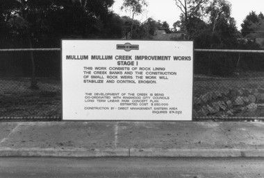
... Sign on wire fence: "Mullum Mullum Creek Improvement Works Stage 1", "This work consists of rock lining the creek banks and the construction of small rock weirs. ...Sign on wire fence: "Mullum Mullum Creek Improvement Works Stage 1", "This work consists of rock lining the creek banks and the construction of small rock weirs. ...Collection of 4 photos of Mullum Mullum Creek Improvement Works. Sign on wire fence: "Mullum Mullum Creek Improvement Works Stage 1", "This work consists of rock lining the creek banks and the construction of small rock weirs. The work will stabilize and control erosion". Estimated Cost $250,000. Undated, but phone number does not have "9" prefix. Possibly early-mid 1980's?(Photo V0174 is a duplicate of V0173 and was not scanned. There is no photo V0172)Nothing written on photograph. -
 Halls Gap & Grampians Historical Society
Photograph - B/W, C 1880
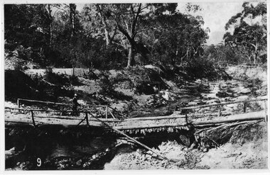
... This bridge was replaced by a higher timber structure but constant erosion of the creek bank eventually led to its replacement by a timber and concrete structure. ...A woman in a white dress and hat is beside the creek and a man is standing near her on the bank. In the left background a house can just be seen through the trees....This bridge was replaced by a higher timber structure but constant erosion of the creek bank eventually led to its replacement by a timber and concrete structure. ...This photo shows the first Delley's Bridge, built to cross the Fyans Creek to provide access to Halls Gap and beyond in the 1880's. The bridge was swept away a number of times in floods. This bridge was replaced by a higher timber structure but constant erosion of the creek bank eventually led to its replacement by a timber and concrete structure. After nearly 50 years of its use, wear and tear necessitated a fourth bridge to be erected in 2001.A log bridge across a creek with a man standing on the bridge. A woman in a white dress and hat is beside the creek and a man is standing near her on the bank. In the left background a house can just be seen through the trees.structures, bridges -
 Dandenong & District Historical Society
Journal, Dandenong & District Historical Society, Gipps-Land Gate Vol.11 No.3, 1984
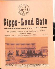
... Titcher, A Dandenong Songster Of The Past The Winds Of Change Personalities Behind The Headstones Dressing Sheds Erected On Creek Bank Keysborough Veteran Hailed From Norway Flashback On The Local Scene ...Titcher, A Dandenong Songster Of The Past The Winds Of Change Personalities Behind The Headstones Dressing Sheds Erected On Creek Bank Keysborough Veteran Hailed From Norway Flashback On The Local Scene Gipps-Land Gate Vol.11 No.3 Journal Dandenong & District Historical Society ...An interesting group of Early Dandenong Personalities, Places and EventsA5 size publication of the Gipps-Land Gate, July - September 1984, 16 pages, featuring an old picture of Dandenong on the cover. Keeping Posted Book Launch Was A Big Success The Bowman Family An Early Dandenong Tramway Harking Back 75 Years Ago The Building Of The Lysterfield Reservior Old Market Identities Recalled Mrs. R. A. Titcher, A Dandenong Songster Of The Past The Winds Of Change Personalities Behind The Headstones Dressing Sheds Erected On Creek Bank Keysborough Veteran Hailed From Norway Flashback On The Local Scene An interesting group of Early Dandenong Personalities, Places and Eventshotel history, early education in dandenong, interesting milestones, family histories -
Glenelg Shire Council Cultural Collection
Negative - Negative - Sapling Creek, Nelson, Victoria, c. 1936
... View of creek through trees on bank...View of creek through trees on bank Negative Negative - Sapling Creek, Nelson, Victoria Miss Zillah Maschmedt, photographer ...Transparency for black and white photo. Sapling Creek, Nelson, Vic. View of creek through trees on bank -
 Clunes Museum
Photograph, AJAX SERIES
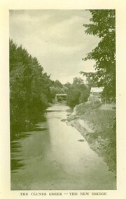
... COPY OF PHOTOGRAPH OF CLUNES CREEK - BLUESTONE "GOVERNMENT" BRIDGE IN THE BACKGROUND, SMALL HUT ON RIGHT HAND BANK OF CREEK....Clunes Museum 36 Fraser Street enter building through Collins Place Clunes goldfields PRODUCED IN VICTORIA local history document postcard bridges THE CLUNES CREEK - THE NEW BRIDGE COPY OF PHOTOGRAPH OF CLUNES CREEK - BLUESTONE "GOVERNMENT" BRIDGE IN THE BACKGROUND, SMALL HUT ON RIGHT HAND BANK OF CREEK. ...PRODUCED IN VICTORIACOPY OF PHOTOGRAPH OF CLUNES CREEK - BLUESTONE "GOVERNMENT" BRIDGE IN THE BACKGROUND, SMALL HUT ON RIGHT HAND BANK OF CREEK.THE CLUNES CREEK - THE NEW BRIDGElocal history, document, postcard, bridges -
 Eltham District Historical Society Inc
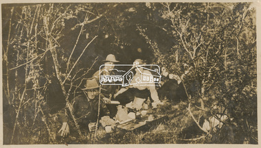
Photograph, Picnic at Eltham with Caffery, Curry, Byrne and McGeachy, 22 Oct 1919
... Broadhurst's companions pose sitting on a creek bank around a open suitcase which containes their picnic spread. ...Broadhurst's companions pose sitting on a creek bank around a open suitcase which containes their picnic spread. ...This photo depicts an outing of VAD nurses Alice Broadhurst, McGeachy and Byrne and two patients of No. 16 AGH Macleod (Mont Park Military Hospital), Curry and Caffery to Eltham in spring 1919. Broadhurst's companions pose sitting on a creek bank around a open suitcase which containes their picnic spread. This photo is part of the Alice Broadhurst collection held by Yarra Plenty Regional Library, a series of 12 photo albums compiled by Alice Broadhurst (1896-1981), initially while working as a Voluntary Aid Detachment nurse with the Australian Red Cross at the Mont Park Military Hospital (No. 16 AGH) and subsequently as a nurse at the Royal Melbourne and Royal Women’s hospitals alongside many pioneering doctors of their fields.Digital fileeltham, alice elizabeth broadhurst, byrne, caffery, curry, mcgeachy, nursing staff, mont park, 16 agh, diamond creek, picnic