Showing 18 items matching "dargo river"
-
 Orbost & District Historical Society
book, Enterprise Press Pty Ltd, Dargo Crooked River, C 1994-1997
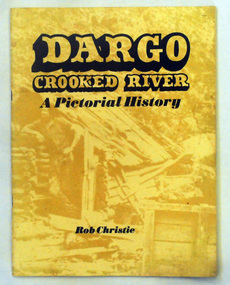
... Dargo Crooked River...Dargo-Crooked-River gold-mining East-Gippsland-history...A thin 56 pp paperback book titled,"Dargo Crooked River a Pictorial History". On the yellow front cover is a sepia photograph of a man standing outside a rough wooden hut. ...Dargo-Crooked-River gold-mining East-Gippsland-history A thin 56 pp paperback book titled,"Dargo Crooked River a Pictorial History". ...This is a pictorial history of the Crooked River district.This is a useful reference tool on the history of gold mining in the Dargo area.A thin 56 pp paperback book titled,"Dargo Crooked River a Pictorial History". On the yellow front cover is a sepia photograph of a man standing outside a rough wooden hut. The title and author are printed in black text over this. The book contains Black / white photographs and the history of Dargo and Crooked River. The information is divided int decades. Inside there is a newspaper cutting of Victorian cattlemen on Junction Plain near Omeo.dargo-crooked-river gold-mining east-gippsland-history -
 Marysville & District Historical Society
Book - Paperback book, Victoria's Forgotten Goldfield-A History of the Dargo, Crooked River Goldfield, 1996
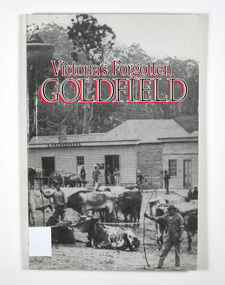
... Victoria's Forgotten Goldfield-A History of the Dargo, Crooked River Goldfield...A history of the Dargo, Crooked River goldfield...Victoria's Forgotten Goldfield-A History of the Dargo, Crooked River Goldfield Book Paperback book ...A history of the Dargo, Crooked River goldfieldPaperback. Cover has a black and white photograph of a couple of buildings surrounded by forest. Photograph is probably of Dargo. One building has a sign that says S. Frankenberg. Another has a sign of which only the letters PION visible. In the photograph there are a number of men standing around the buildings as well as what appears to be two children sitting on a bench outside a building. There is also a large wagon-like vehicle to which is attached are a large train of oxen. In the foreground of the photograph is another group of oxen which appear to be chained together. There is also two men standing near the second group of oxen, both appear to be holding whips.The stamp of the Marysville & District Historical Society Inc / P.O. Box 22 / Marysville 3779gold, gold mining, gold town, dargo, gold miner, gold field, gippsland, victoria, australia, history -
 Lakes Entrance Historical Society
Book, Rob Christie, Dargo Crooked River a Pictorial History 2000 edition, 1984
... Dargo Crooked River a Pictorial History 2000 edition...Short history of the Dargo Crooked River goldfield, which operated 1860 to 1900, illustrated with photographs....Dargo Crooked River a Pictorial History 2000 edition Book Rob Christie ...Short history of the Dargo Crooked River goldfield, which operated 1860 to 1900, illustrated with photographs.mines and mining -
 Victorian Aboriginal Corporation for Languages
Book, P D Gardner, Names of the Victorian Alps : their origins, meanings and history, 1991
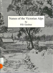
... ...Dargo River...Victorian Aboriginal Corporation for Languages 33 Saxon Street Brunswick melbourne Jaitmathang Minjambuta Djilimatang Ngarigo Brabiralung Braiakaulung Yuin Gunnai Lake Tyers Dargo River Omeo Bright Swifts Creek Benambra Ovens Valley Mount Hotham Mount Nugong Wonnangatta Station Maps, b&w illustrations, b&w photographs Gives a comprehensive account of the origins of local names in the area. ...Gives a comprehensive account of the origins of local names in the area. Anecdotes of interesting pieces of history.Maps, b&w illustrations, b&w photographsjaitmathang, minjambuta, djilimatang, ngarigo, brabiralung, braiakaulung, yuin, gunnai, lake tyers, dargo river, omeo, bright, swifts creek, benambra, ovens valley, mount hotham, mount nugong, wonnangatta station -
Lakes Entrance Historical Society
Book, Christie, R.W. and Gray, G.D, Victorias Forgotten Goldfield, 1981
... A History of the Dargo, Crooked River Goldfield...Lakes Entrance Historical Society 4 Marine Parade Lakes Entrance gippsland Metals Mines and Mining A History of the Dargo, Crooked River Goldfield Victorias Forgotten Goldfield Book Christie, R.W. and Gray, G.D. ...A History of the Dargo, Crooked River Goldfieldmetals, mines and mining -
Lakes Entrance Historical Society
Map - Tambo Counties of Dargo and Tambo, A C Brooks Gov. Printer
... Shows townships of Bruthen, Dargo, Tambo River, Omeo Highway, Land owners...Lakes Entrance Historical Society 4 Marine Parade Lakes Entrance gippsland Townships Roads and Streets Land Settlement Waterways Shows townships of Bruthen, Dargo, Tambo River, Omeo Highway, Land owners Map Tambo Counties of Dargo and Tambo A C Brooks Gov. ...Shows townships of Bruthen, Dargo, Tambo River, Omeo Highway, Land ownerstownships, roads and streets, land settlement, waterways -
Lakes Entrance Historical Society
Book, Rob Christie, Cargo Crooked River 1984 edition, 2000
... This updated edition gives a broader picture of life on the Dargo Crooked River goldfields, Illustrated with photographs and maps....Lakes Entrance Historical Society 4 Marine Parade Lakes Entrance gippsland Mines and Mining Township This updated edition gives a broader picture of life on the Dargo Crooked River goldfields, Illustrated with photographs and maps. ...This updated edition gives a broader picture of life on the Dargo Crooked River goldfields, Illustrated with photographs and maps.mines and mining, township -
 Lakes Entrance Historical Society
Photograph - SS Dargo
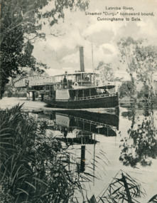
... Black and white digital photo of the Dargo on the LaTrobe River Sale ...Latrobe River, Steamer 'Dargo' homeward bound, Cunninghame to Sale ...Shipping Rivers Tourism Waterways Latrobe River, Steamer 'Dargo' homeward bound, Cunninghame to Sale Black and white digital photo of the Dargo on the LaTrobe River Sale Photograph SS Dargo ...Black and white digital photo of the Dargo on the LaTrobe River Sale Latrobe River, Steamer 'Dargo' homeward bound, Cunninghame to Sale shipping, rivers, tourism, waterways -
 Ringwood and District Historical Society
Book, Elizabeth Dole Porteus, Let's Go Exploring: The Life Of Stanley D. Porteus - Hawaii's Pioneer Psychologist, 1991
... Dargo Road, some 35 miles north west of Bairnsdale. He walked about 6 miles from the nearest railway station at Fernbank to find the school surrounded by virgin forest with only one dwelling in sight. Attached to the school were lean-to rooms that were to be his residence for the next 2 ½ years. He was fascinated by the nearby Den of Nargun and Bull Creek, which joined the Mitchell River...Dargo Road, some 35 miles north west of Bairnsdale. He walked about 6 miles from the nearest railway station at Fernbank to find the school surrounded by virgin forest with only one dwelling in sight. Attached to the school were lean-to rooms that were to be his residence for the next 2 ½ years. He was fascinated by the nearby Den of Nargun and Bull Creek, which joined the Mitchell River ...White hard covered book. Biography by daughter-in-law of Stanley Porteus, pioneer of modern psychology and one-time resident of Ringwood, Victoria. SUMMARY NOTES. Stanley David Porteus was born in Box Hill, Victoria, Australia in 1883, the only son of a Methodist minister. Like other now large suburbs of Melbourne such as Canterbury, Mitcham and Ringwood, Box Hill was a mere village. Each was surrounded by bush. He grew up like most Australian boys with a love of sport and, although lightly built, did quite well at Australian Rules football and was above average at cricket. He became a schoolteacher with the Victorian Education Department. Promotion within the department depended on experience gained at teaching in tiny rural schools so he applied for such a position at Glenaladale, on the Dargo Road, some 35 miles north west of Bairnsdale. He walked about 6 miles from the nearest railway station at Fernbank to find the school surrounded by virgin forest with only one dwelling in sight. Attached to the school were lean-to rooms that were to be his residence for the next 2 ½ years. He was fascinated by the nearby Den of Nargun and Bull Creek, which joined the Mitchell River in a deep gorge containing a profusion of rainforest vegetation. While at Glenaladale, he met Frances Evans who became his wife. To seek promotion, he left Glenaladale and taught at Leneva and Benambra. While at the latter school, he learned of a position becoming available as superintendent of special schools in Melbourne. As the available means of transport, coach and horses to Bairnsdale, then by train to Melbourne, would not get him to Melbourne before the close of applications, he borrowed a bicycle and rode through the bush to his in-laws home at Lindenow and thus made it before the deadline. He was successful in his application and it set him on a course that lead to him becoming Australia's first Clinical Psychologist. His work, particularly, the development of the Porteus Maze Test, attracted the attention of American educators and he was offered an appointment for a year at Vineland Training School in New Jersey. On a stopover in Honolulu, he was impressed to the extent that he expressed a desire to work there. Not the least of its attractions was the mix of races that offered opportunities to study psychological differences, if any, between various races. His wish was to be granted unexpectedly as he was, in 1919, invited to Honolulu to set up a Psychological and Psychopathic Clinic at the University of Hawaii. From his home in the hills north of Honolulu, on December 7th 1941, he saw the Japanese attack on Pearl Harbour. He lived there until his death in about 1980. -
Federation University Historical Collection
Reports, Big Cat sightings (dates), 1989
... dargo...inglewood...doncaster east...tidal river...Barker Library (top floor) Mount Helen goldfields australian mythical animals collection david waldron dse big cats panthers pumas nuggety gippsland black cats tasmanian tiger marysville wood's point thylacine south gippsland felid gippsland big cat kelvin healey peter hall sherbrooke forest woodside walaces flat mountain lion heyfield mt taylor walhalla mt selma warrnambool kyneton korumburra canadian forest grampians panton hill beaconsfield apollo bay forrest victoria valley rapanyup dargo inglewood doncaster east tidal river cape bridgewater walkerville dooen st arnaud lake bung bong mitta mitta moliagul emerald kinglake cape otway dereel leonard's hill daylesford korweinguboora lal lal noojee eltham lancefield trentham daisy hill tanjil south wonthaggi cockatoo warrenheip greendale howqua lake buchan melville caves portland mt elephant morwell navarre yarram yandoit moonambel maryborough taravale coghill's creek trentham carisbrook inglewood warrenmang yarragon creswick emerald stawel clunes majorca heathcote talbot daylesford newham broadford peter chapple Research of dated sightngs of Big cats in Victoria from 1868-1989. ...Research of dated sightngs of Big cats in Victoria from 1868-1989. australian mythical animals collection, david waldron, dse, big cats, panthers pumas, nuggety, gippsland, black cats, tasmanian tiger, marysville, wood's point, thylacine, south gippsland, felid, gippsland big cat, kelvin healey, peter hall, sherbrooke forest, woodside, walaces flat, mountain lion, heyfield, mt taylor, walhalla, mt selma, warrnambool, kyneton, korumburra, canadian forest, grampians, panton hill, beaconsfield, apollo bay, forrest, victoria valley, rapanyup, dargo, inglewood, doncaster east, tidal river, cape bridgewater, walkerville, dooen, st arnaud, lake bung bong, mitta mitta, moliagul, emerald, kinglake, cape otway, dereel, leonard's hill, daylesford, korweinguboora, lal lal, noojee, eltham, lancefield, trentham, daisy hill, tanjil south, wonthaggi, cockatoo, warrenheip, greendale, howqua, lake buchan, melville caves, portland, mt elephant, morwell, navarre, yarram, yandoit, moonambel, maryborough, taravale, coghill's creek, trentham, carisbrook, inglewood, warrenmang, yarragon, creswick, emerald, stawel, clunes, majorca, heathcote, talbot, daylesford, newham, broadford, peter chapple -
 Old Gippstown
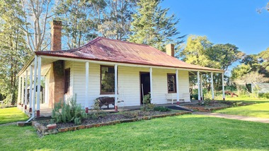
Building - Bushy Park
... River...Boisedale...Briagolong...Dargo...McMillan Angus Old Gippstown West Gippsland Gippsland Gippsland Heritage Park Goldfields Victorian era Moe Historical Village Wellington Shire Avon River Boisedale Briagolong Dargo Murdoch Mackintosh National Trust Andrew Martin and Matt McCraw. ...13 August 1843 First application for the Bushy Park run appeared in the “Port Phillip Gazette”. It was taken up by Angus McMillan, who took up the Boisdale run across the Avon River at the same time, for his employer Lachlan Macalister. This house was built in 1848. March 1844 Licence to Bushy Park granted to McMillan. It consisted of 16,000 acres. Late 1840s Bushy Park homestead built for McMillan by Andrew Martin and Matt McCraw. High local historic significance as associated with major pioneer and a very old white settlement in Gippsland.A square shaped timber house, with a corrugated iron roof over shingles. It has a verandah that covers both the front and sides of the house. The house is contructed of redgum timber, and internally has four rooms.National Trust of Australia Plaque - Bushy Park Homestead - Class 'C'mcmillan, angus, old gippstown, west gippsland, gippsland, gippsland heritage park, goldfields, victorian era, moe, historical village, wellington shire, avon river, boisedale, briagolong, dargo, murdoch mackintosh, national trust, andrew martin and matt mccraw., latrobe valley, old gippstown heritage park, gunaikurnai, latrobe city council -
Lakes Entrance Historical Society
Map - Dargo, Dept of Lands and Survey
... Lakes Entrance Historical Society 4 Marine Parade Lakes Entrance gippsland Land Settlement Waterways Shows areas from Benambra, Bongong to Tanjil, Wongurra River Map Dargo Dept of Lands and Survey ...Shows areas from Benambra, Bongong to Tanjil, Wongurra Riverland settlement, waterways -
Lakes Entrance Historical Society
Map - Bumberrah Counties of Dargo and Tambo
... Lakes Entrance Historical Society 4 Marine Parade Lakes Entrance gippsland Waterways Forest Township landowners Shows landowners, state forest, Colquhoun North and Tambo River, Tambo Bay and Nicholson River. Map Bumberrah Counties of Dargo and Tambo ...Shows landowners, state forest, Colquhoun North and Tambo River, Tambo Bay and Nicholson River.waterways, forest, township, landowners -
Lakes Entrance Historical Society
Map - Bumberrah Counties of Dargo and Tambo
... River. 5 maps A, B C, D, E. B is laminated, C, D, and E are photocopies Map Bumberrah Counties of Dargo and Tambo ...Map showing land owners, state forest, Colquhoun North, Tambo River, Tambo Bay, Nicholson River. 5 maps A, B C, D, E. B is laminated, C, D, and E are photocopieswaterways, forest, land owners -
Lakes Entrance Historical Society
Book, North East Regional Tourist Authority, North East Victoria, 1980
... A brief record of the region from the Murray River in the north to the Dargo High Plains in the south, from Yarrawonga and Wangaratta in the west to the Indi River in the east. ...Lakes Entrance Historical Society 4 Marine Parade Lakes Entrance gippsland Tourism Mines and Mining Settlers Water supply A brief record of the region from the Murray River in the north to the Dargo High Plains in the south, from Yarrawonga and Wangaratta in the west to the Indi River in the east. ...A brief record of the region from the Murray River in the north to the Dargo High Plains in the south, from Yarrawonga and Wangaratta in the west to the Indi River in the east. Illustrated with coloured photographs.tourism, mines and mining, settlers, water supply -
 Lakes Entrance Historical Society
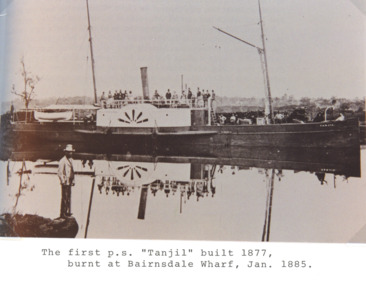
Photograph - PS Tanjil, 1880 c
... Black and white photograph of the first PS Tanjil in the Mitchell Rivers Bairnsdale Victoria. Plus two photos of the second PS Dargo....Lakes Entrance Historical Society 4 Marine Parade Lakes Entrance gippsland PS Tanjil was burnt to the waterline in 1885 Boats and Boating Waterways Black and white photograph of the first PS Tanjil in the Mitchell Rivers Bairnsdale Victoria. Plus two photos of the second PS Dargo. Photograph PS Tanjil ...PS Tanjil was burnt to the waterline in 1885Black and white photograph of the first PS Tanjil in the Mitchell Rivers Bairnsdale Victoria. Plus two photos of the second PS Dargo.boats and boating, waterways -
 Wodonga & District Historical Society Inc
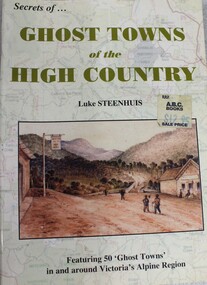
Book - Ghost Towns of the High Country, Luke Steenhuis, 1998
... Towns include Boggy Creek, Brandy Creek, Brocket, Brookville, Buckland, Buckland Upper, Bulgoback, Bulltown, Hogtown, Bullumwaal, Canvastown, Cassilis, Cobbannah, Copenhagen, Dargo High Plains, Dartmouth, Deptford, Gibbo River, Gladstone, Glen Dart, Glen Valley, Glen Wills, Good Luck Creek, Granite Flat, Grant, Hinnomunjie, Howittville, Jeff Davis, Lightning Creek, Louisville, Mayford, Merrijig Creek, Mitchelldale, Mount Elmo, Nugong, Sassafras, Saltpetre, Staleyville, Stirling, Store Creek, Summer Hill, Sunnyside, Tabberabbera, Talbotville, Thiel Town, Tongio West, Waterford, Wentworth River, Winchester, Wombat, Wongungarra, Zulu Creek. ...Stories and information about former towns in and around Victoria's Alpine Region. Towns include Boggy Creek, Brandy Creek, Brocket, Brookville, Buckland, Buckland Upper, Bulgoback, Bulltown, Hogtown, Bullumwaal, Canvastown, Cassilis, Cobbannah, Copenhagen, Dargo High Plains, Dartmouth, Deptford, Gibbo River, Gladstone, Glen Dart, Glen Valley, Glen Wills, Good Luck Creek, Granite Flat, Grant, Hinnomunjie, Howittville, Jeff Davis, Lightning Creek, Louisville, Mayford, Merrijig Creek, Mitchelldale, Mount Elmo, Nugong, Sassafras, Saltpetre, Staleyville, Stirling, Store Creek, Summer Hill, Sunnyside, Tabberabbera, Talbotville, Thiel Town, Tongio West, Waterford, Wentworth River, Winchester, Wombat, Wongungarra, Zulu Creek.non-fictionStories and information about former towns in and around Victoria's Alpine Region. Towns include Boggy Creek, Brandy Creek, Brocket, Brookville, Buckland, Buckland Upper, Bulgoback, Bulltown, Hogtown, Bullumwaal, Canvastown, Cassilis, Cobbannah, Copenhagen, Dargo High Plains, Dartmouth, Deptford, Gibbo River, Gladstone, Glen Dart, Glen Valley, Glen Wills, Good Luck Creek, Granite Flat, Grant, Hinnomunjie, Howittville, Jeff Davis, Lightning Creek, Louisville, Mayford, Merrijig Creek, Mitchelldale, Mount Elmo, Nugong, Sassafras, Saltpetre, Staleyville, Stirling, Store Creek, Summer Hill, Sunnyside, Tabberabbera, Talbotville, Thiel Town, Tongio West, Waterford, Wentworth River, Winchester, Wombat, Wongungarra, Zulu Creek.ghost towns, high country victoria, pioneers, history victoria -
Lakes Entrance Historical Society
Print - Nurong County of Dargo, 21/3/2024
... Waterways Land Settlement Kooroon, Koomberar, Yonduk, Kianeek shows Yahoo Creek, Nicholson River, Land owner W G Hamilton Print Nurong County of Dargo ...Kooroon, Koomberar, Yonduk, Kianeek shows Yahoo Creek, Nicholson River, Land owner W G Hamiltonwaterways, land settlement