Showing 467 items matching "department of lands and surveys"
-
 Marysville & District Historical Society
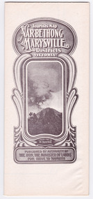
Map (Item) - Tourist Map, Department of Lands & Survey, Tourist's Map of Narbethong and Marysville Districts Victoria, 1913
... ...department of lands & survey...A tourist map for the Narbethong and Marysville Districts that was originally produced by the Department of Lands & Survey in 1925....A tourist map for the Narbethong and Marysville Districts that was originally produced by the Department of Lands & Survey in 1925....Photo Lithographed at the Department of Lands and Survey Melbourne by W.J. Butson/ 26.8.13...Department of Lands & Survey...Photo Lithographed at the Department of Lands and Survey Melbourne by W.J. Butson/ 26.8.13 A tourist map for the Narbethong and Marysville Districts that was originally produced by the Department of Lands & Survey in 1925. ...A tourist map for the Narbethong and Marysville Districts that was originally produced by the Department of Lands & Survey in 1925.A tourist map for the Narbethong and Marysville Districts that was originally produced by the Department of Lands & Survey in 1925.Reprint of the 1925 Tourist brochure by permission R.E. Holmes Surveyor General By Authority: ALBERT J. MULLETT, Government Printer, Melbourne. Photo Lithographed at the Department of Lands and Survey Melbourne by W.J. Butson/ 26.8.13narbethong, marysville, victoria, department of lands & survey, the acheron valley, warburton, map, tourist map -
 Marysville & District Historical Society
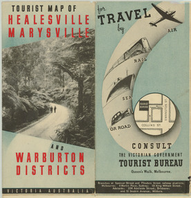
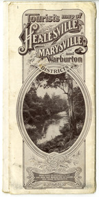
Map (Item) - Tourist Map, Department of Lands & Survey, Tourist Map of Healesville, Marysville and Warburton Districts, 1938
... A tourist map for Healesville, Marysville and Warburton that was produced by the Victorian Department of Crown Lands and Survey, in conjunction with Victorian Railways, in 1938....A tourist map for Healesville, Marysville and Warburton that was produced by the Victorian Department of Crown Lands and Survey, in conjunction with Victorian Railways, in 1938....Compiled by the Department of Lands and Survey, Melbourne Issued by the Betterment and Publicity Board, Victorian Railways, Melbourne, Victoria. ...Department of Lands & Survey...Tourist Map of Healesville, Marysville and Warburton Districts Map Tourist Map Department of Lands & Survey Victorian Railways ...A tourist map for Healesville, Marysville and Warburton that was produced by the Victorian Department of Crown Lands and Survey, in conjunction with Victorian Railways, in 1938.A tourist map for Healesville, Marysville and Warburton that was produced by the Victorian Department of Crown Lands and Survey, in conjunction with Victorian Railways, in 1938.Compiled by the Department of Lands and Survey, Melbourne Issued by the Betterment and Publicity Board, Victorian Railways, Melbourne, Victoria. May 1938healesville, marysville, warburton, victoria, tourist information, tourism, map, tourist map, victorian deparment of crown lands and survey, victorian railways, betterment and publicity board -
 Sunshine and District Historical Society Incorporated
Map - Map Shire of Braybrook, 1950s
... Fabric backed map, Department of Lands and Survey, Melb. Abt 1950. Shire of Braybrook. ...Department of Lands and Survey Shire of Braybrook...Shire of Braybrook Map Department of Lands and Survey Shire of Braybrook Fabric backed map, Department of Lands and Survey, Melb. ...Department of Lands and Survey Shire of Braybrookshire of braybrook, map -
 Bacchus Marsh & District Historical Society
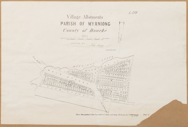
Map, Village allotments, Parish of Myrniong, County of Bourke
... Photo-lithographed at the Department of Lands & Survey, Melbourne, in 1903. ...Surveyed by John Hardy, Surveyor ; photo-lithographed at the Department of Lands & Survey, Melbourne by T.F. ...Photo-lithographed at the Department of Lands & Survey, Melbourne, in 1903. ...Myrniong is a village 9 kilometers west of Bacchus Marsh. Prior to 1863 the area was known as Blow's Flat. This map which was produced in 1903 and according to the catalogue record of this map held at the State Library of Victoria was based on an earlier map created in 1861. The early layout of streets for the village of Myrniong can be seen on this map. The streets shown are, Main Street, Hardy Street, Blow Street, Myrniong Street, Shuter Street, and Blackwood Street. An area marked as a reserve for a school can be seen between Hardy Street and Main Street.A single page paper map. A cadastral parish map of Myrniong in Victoria, showing numbered land allotments. Photo-lithographed at the Department of Lands & Survey, Melbourne, in 1903. Based on an original map created in 1861. The map is pasted into a bound volume containing 76 maps or plans in total. High resolution digital image stored on BMDHS computer network. Surveyed by John Hardy, Surveyor ; photo-lithographed at the Department of Lands & Survey, Melbourne by T.F. McGauran, 24.12.03myrniong parish plan, myrniong parish maps -
 Whitehorse Historical Society Inc.
Map, M.M.B.W, c1962
... ...Victoria. Department of Lands and Survey...Prepared by Department of Lands and Survey and Melbourne and Metropolitan Board of Works from State aerial Survey, June 1957 and Cadastral Survey information, August 1960. ...Prepared by Department of Lands and Survey and Melbourne and Metropolitan Board of Works from State aerial Survey, June 1957 and Cadastral Survey information, August 1960. ...Prepared by Department of Lands and Survey and Melbourne and Metropolitan Board of Works from State aerial Survey, June 1957 and Cadastral Survey information, August 1960. ...Melbourne Metropolitan Area Base Map series sheet 235, covering part, Mitcham, Nunawading and Ringwood areas.Melbourne Metropolitan Area Base Map series sheet 235, covering part, Mitcham, Nunawading and Ringwood areas. Prepared by Department of Lands and Survey and Melbourne and Metropolitan Board of Works from State aerial Survey, June 1957 and Cadastral Survey information, August 1960. Scale 1:4,800.Melbourne Metropolitan Area Base Map series sheet 235, covering part, Mitcham, Nunawading and Ringwood areas. maps, mitcham, nunawading, ringwood, melbourne and metropolitan board of works, victoria. department of lands and survey -
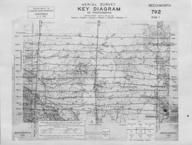 The Beechworth Burke Museum
Photograph - Aerial Survey, 5/9/1947
... ...department of lands and survey...Issued by Department of Lands and Survey, Victoria in 1947. ...Obverse: AERIAL SURVEY, KEY DIAGRAM OF PHOTOGRAPHS, APPROXIMATE SCALE OF MILES / DEPARTMENT OF LANDS AND SURVEY VICTORIA 5.9.1947. ...Issued by Department of Lands and Survey, Victoria in 1947. ...This image is an Aerial Survey, Key Diagram of Beechworth and surrounding area. Issued by Department of Lands and Survey, Victoria in 1947. Photographed at an average height of 12300 feet above sea level, areas depicted are; Beechworth, Stanley, Bruarong, Baranduda, Muagegonga, Myrtleford, Everton, Wooragee North Tarrawinge, Dederang, Kergunyah North, Kergunyah, Yackandandah, El-Dorado, Barambogie, Murmungee, Barwidgee, Oxley, CarraragarmungeeBlack and white rectangular photograph. Image is printed on matt photographic paper and has a white un-printed border. Obverse: AERIAL SURVEY, KEY DIAGRAM OF PHOTOGRAPHS, APPROXIMATE SCALE OF MILES / DEPARTMENT OF LANDS AND SURVEY VICTORIA 5.9.1947. BEECHWORTH 792 ZONE 7. Reverse: BMM7010.1 (written in pencil) aerial survey, beechworth, burke museum, department of lands and survey, victoria, 1947 -
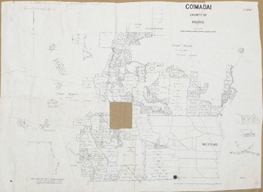 Bacchus Marsh & District Historical Society
Map, Coimadai Parish Map, County of Bourke. Circa 1890s-1900s
... McGauran the person who made a photo-lithographic copy of the map was in charge of photo-lithography at the Victorian Department of Lands and Survey in the late 19th century until about 1910....Photo-lithographed at the Department of Lands and Survey, Melbourne by T.F. ...Bacchus Marsh Region Parish Plans Coimadai Parish Maps Coimadai Parish Plan Photo-lithographed at the Department of Lands and Survey, Melbourne by T.F. ...The cadastral Parish of Coimadai, a subdivision of the County of Bourke, lies directly north of the township of Bacchus Marsh. The date of this map is uncertain. T.F. McGauran the person who made a photo-lithographic copy of the map was in charge of photo-lithography at the Victorian Department of Lands and Survey in the late 19th century until about 1910.A single page paper map showing the map for the Parish of Coimadai in the County of Bourke. A cadastral map showing parish boundaries and land ownership. A rectangle shaped area is missing from the centre of the map due to a tear or deliberate excision. The map is pasted into a bound volume containing 76 maps or plans in total. High resolution digital image stored on BMDHS computer network. Photo-lithographed at the Department of Lands and Survey, Melbourne by T.F. McGauran 26.8.[??] NOTE. Photo litho from L.P showing temporary surveys and occupation of land prepared for departmental use onlybacchus marsh region parish plans, coimadai parish maps, coimadai parish plan -
 Rutherglen Historical Society
Document - License to thin trees, 1899 (Exact)
... "Department of Lands and Survey. On Forest Business"...Secretary for Lands, Department of Lands and Survey / On Forest Business...On back, copy of Land Act Regulations 1890 Document License to thin trees Secretary for Lands, Department of Lands and Survey / On Forest Business ...Dated July 14th 1899. Sent to Mr W. Cooper / c/o Mr Barrie / Storekeeper / No. 2 Valley / Chiltern / "Copy of Land Act 1896 / Regulations. Chapter XI Thinning Licenses"Document on stiff paper. Letter to Mr W. Cooper granting license to thin trees on a block of land at Chiltern Reserve. On back, copy of Land Act Regulations 1890"Department of Lands and Survey. On Forest Business"license, timber felling, cooper family, forestry, chiltern reserve -
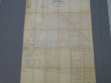 Bendigo Historical Society Inc.
Map - JACK FLYNN COLLECTION: DERBY, 12/05/1892
... Department of Lands and Survey Melbourne by T.F.McGauran, 12.5.92...History House 11 Mackenzie Street Bendigo goldfields MAP Bendigo parish plan Derby Department of Lands and Survey Melbourne by T.F.McGauran, 12.5.92 Map: Derby, County of Bendigo. ...Map: Derby, County of Bendigo. Parish plan.Department of Lands and Survey Melbourne by T.F.McGauran, 12.5.92map, bendigo, parish plan, derby -
 Bendigo Historical Society Inc.
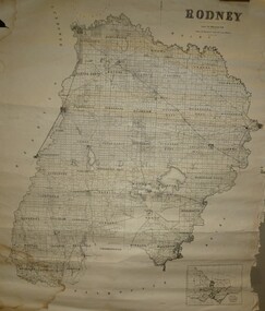
Map - JACK FLYNN COLLECTION: RODNEY, Revised in 1935
... Drawn at the Department of Lands and Survey, Melbourne. Revised to 1935...History House 11 Mackenzie Street Bendigo goldfields MAP Rodney parish plan Rodney Drawn at the Department of Lands and Survey, Melbourne. Revised to 1935 Map: County of Rodney, map sheet showing the whole of the County of Rodney and all of the Parishes within. ...Map: County of Rodney, map sheet showing the whole of the County of Rodney and all of the Parishes within.Drawn at the Department of Lands and Survey, Melbourne. Revised to 1935map, rodney, parish plan, rodney -
 Ringwood and District Historical Society
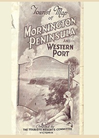
Memorabilia, Tourist Map of Mornington Peninsula and Western Port - 1929
... Photo-Lithographed by Department of Lands and Survey, Melbourne, 2.8.1929....Ringwood and District Historical Society 125A Warrandyte Road Ringwood North melbourne Photo-Lithographed by Department of Lands and Survey, Melbourne, 2.8.1929. ...Multi-fold pictorial map of towns, railways and main roads east of Port Phillip Bay from Melbourne to Yarra Junction and south to Phillip Island and Wonthaggi, backed by details of main features and points of interest.Photo-Lithographed by Department of Lands and Survey, Melbourne, 2.8.1929. -
Stawell Historical Society Inc
Map - Parish Map, Department of Lands and Survey, Ashens County of Borung 1941, 1941
... Drawn and Reproduced at the department of Lands and Survey Melbourne 1.5.1941...Department of Lands and Survey...Stawell Historical Society Inc 46 Longfield St Stawell grampians Murtoa Lake Marma Survey Drawn and Reproduced at the department of Lands and Survey Melbourne 1.5.1941 Paper Brown Coloured Map Ashens County of Borung 1941 Map Parish Map Department of Lands and Survey ...Murtoa Lake MarmaPaper Brown Coloured MapDrawn and Reproduced at the department of Lands and Survey Melbourne 1.5.1941survey -
 Bendigo Historical Society Inc.
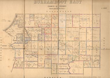
Map - JACK FLYNN COLLECTION: BURRUMBOOT EAST, 21/12/1027
... Photo Lithographed at the Department of Lands and Survey, Melbourne by W.J.Butson. 21.12.27...History House 11 Mackenzie Street Bendigo goldfields MAP Rodney parish plan Burrumboot East Photo Lithographed at the Department of Lands and Survey, Melbourne by W.J.Butson. 21.12.27 Map: Burrumboot East, County of Rodney. ...Map: Burrumboot East, County of Rodney. Parish plan.Photo Lithographed at the Department of Lands and Survey, Melbourne by W.J.Butson. 21.12.27map, rodney, parish plan, burrumboot east -
 Bendigo Historical Society Inc.
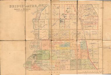
Map - JACK FLYNN COLLECTION: BRIDGEWATER, 6/10/1927
... Photo Lithographed at the Department of Lands and Survey, Melbourne by W.J. ...History House 11 Mackenzie Street Bendigo goldfields MAP Bendigo parish plan Bridgewater Photo Lithographed at the Department of Lands and Survey, Melbourne by W.J. ...Map: Bridgewater , County of Bendigo. Parish plan.Photo Lithographed at the Department of Lands and Survey, Melbourne by W.J. Butson.map, bendigo, parish plan, bridgewater -
 Bendigo Historical Society Inc.
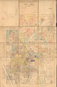
Map - JACK FLYNN COLLECTION: NEILBOROUGH, 13/10/1927
... Photo Lithographed at the Department of Lands and Survey, Melbourne by W.J. ...History House 11 Mackenzie Street Bendigo goldfields MAP Bendigo parish plan Neilborough Photo Lithographed at the Department of Lands and Survey, Melbourne by W.J. ...Map: Parish of Neilborough, County of Bendigo. Parish plan.Photo Lithographed at the Department of Lands and Survey, Melbourne by W.J. Butsonmap, bendigo, parish plan, neilborough -
 Bendigo Historical Society Inc.
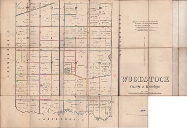
Map - JACK FLYNN COLLECTION: WOODSTOCK, 27/03/75
... Photo-Lithographed at the Department of Lands and Survey Melbourne by J. Noone. 27.3.79...History House 11 Mackenzie Street Bendigo goldfields MAP Bendigo parish plan Woodstock Photo-Lithographed at the Department of Lands and Survey Melbourne by J. Noone. 27.3.79 Map: Parish of Woodstock , County of Bendigo. ...Map: Parish of Woodstock , County of Bendigo. Parish plan.Photo-Lithographed at the Department of Lands and Survey Melbourne by J. Noone. 27.3.79map, bendigo, parish plan, woodstock -
 Bendigo Historical Society Inc.
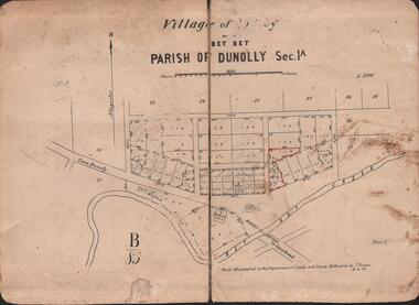
Map - JACK FLYNN COLLECTION: VILLAGE OF BETLEY, 30/06/1874
... Photo Lithographed at the Department of Lands and Survey Melbourne by J. Noone 30.6.74...History House 11 Mackenzie Street Bendigo goldfields MAP Gladstone village Betley Bet Bet Creek Dunolly Photo Lithographed at the Department of Lands and Survey Melbourne by J. Noone 30.6.74 Map: Village of Betley, on the Bet Bet Creek, Parish of Dunolly. ...Map: Village of Betley, on the Bet Bet Creek, Parish of Dunolly. Parish plan.Photo Lithographed at the Department of Lands and Survey Melbourne by J. Noone 30.6.74map, gladstone, village, betley, bet bet creek, dunolly -
 Bendigo Historical Society Inc.
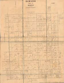
Map - JACK FLYNN COLLECTION: BAMAWM, 19/08/1924
... Photo Lithographed at the Department of Lands and Survey, Melbourne by W.J. ...History House 11 Mackenzie Street Bendigo goldfields MAP Bendigo parish plan Bamawm Photo Lithographed at the Department of Lands and Survey, Melbourne by W.J. ...Map: Parish of Bamawm, County of Bendigo. Parish plan.Photo Lithographed at the Department of Lands and Survey, Melbourne by W.J. Butson. 19.8.24map, bendigo, parish plan, bamawm -
 Marysville & District Historical Society
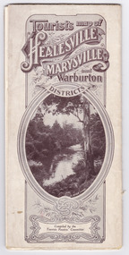
Map (Item) - Tourist Map, Tourists Resorts' Committee, Tourist's Map of Healesville Marysville and Warburton Districts, 13.10.1925
... Photo Lithographed at the Department of Lands and Survey, Melbourne by W.J. ...A tourist map for Healesville, Marysville and Warburton that was produced by the Tourists Resorts' Committee. healesville marysville warburton victoria tourists resorts' committee ben cairn mount donna buang the black's spur the acheron valley narbethong launching place tourist information tourism map tourist map Photo Lithographed at the Department of Lands and Survey, Melbourne by W.J. ...A tourist map for Healesville, Marysville and Warburton that was produced by the Tourists Resorts' Committee. This map was produced in 1925.A tourist map for Healesville, Marysville and Warburton that was produced by the Tourists Resorts' Committee.Photo Lithographed at the Department of Lands and Survey, Melbourne by W.J. Butson./ 13.10.25healesville, marysville, warburton, victoria, tourists resorts' committee, ben cairn, mount donna buang, the black's spur, the acheron valley, narbethong, launching place, tourist information, tourism, map, tourist map -
 Marysville & District Historical Society
Map (Item) - Tourist Map, Tourists Resorts' Committee, Tourist's Map of Healesville Marysville and Warburton Districts, 13.10.1925
... Photo Lithographed at the Department of Lands and Survey, Melbourne by W.J. ...A tourist map for Healesville, Marysville and Warburton that was produced by the Tourists Resorts' Committee. healesville marysville warburton victoria tourists resorts' committee ben cairn mount donna buang the black's spur the acheron valley narbethong launching place tourist information tourism map tourist map Photo Lithographed at the Department of Lands and Survey, Melbourne by W.J. ...A tourist map for Healesville, Marysville and Warburton that was produced by the Tourists Resorts' Committee. This map was produced in 1925.A tourist map for Healesville, Marysville and Warburton that was produced by the Tourists Resorts' Committee.Photo Lithographed at the Department of Lands and Survey, Melbourne by W.J. Butson./ 13.10.25healesville, marysville, warburton, victoria, tourists resorts' committee, ben cairn, mount donna buang, the black's spur, the acheron valley, narbethong, launching place, tourist information, tourism, map, tourist map -
Stawell Historical Society Inc
Map, T.F. McGauran, William Couty of Borong 1891, 1891
... Photo Lithographed at the Department of Lands and Survey Melbourne. By T.F. ...Stawell Water Supply Aquaduct Fkuming Tunnel. Water Supply Survey Photo Lithographed at the Department of Lands and Survey Melbourne. ...Stawell Water Supply Reserve. Grampians State Forest. Dairy Creek, Fyans Creek, Barney's Creek, Bovine Creek, Glasstree Creek, Stoney Creek. Stawell Water Supply Aquaduct Fkuming Tunnel.A2 Parish Map of Willam Inculdin Stawell Water Supply Reserve and Creeks. Marked in redPhoto Lithographed at the Department of Lands and Survey Melbourne. By T.F. McGauran 20.07.91 water supply survey -
Stawell Historical Society Inc
Map, T.F. McGauran, Winjallock County of Kara Kara, 1900
... Photo Lithographed and the department of Lands & Survey, Melbourne by T.F. McCauran 22.10.00...Stawell Historical Society Inc 46 Longfield St Stawell grampians Noth of Navarre and Barkley Survey Photo Lithographed and the department of Lands & Survey, Melbourne by T.F. ...Noth of Navarre and BarkleyA2 Map0f Parish of Kara Kara.Photo Lithographed and the department of Lands & Survey, Melbourne by T.F. McCauran 22.10.00survey -
Stawell Historical Society Inc
Map, Department of Lands & Survey J. Noone, Township of Heatherlie. Parish of Baroka. County of Borung 1888, 1888
... photo Lithographed at the Department of lands and Survey Melbourne By J Noone 15.6.88...Department of Lands & Survey J. Noone...County of Borung 1888 Map Department of Lands & Survey J. Noone ...Stawell & Grampians Freestone Quarry Company Railway Reserve. Cross & masons Quarry Site. Mamnager'sHouse, Stead's boarding House Stawell and Grampians railwaySurveyed Township Showing Quarry and railway Reservephoto Lithographed at the Department of lands and Survey Melbourne By J Noone 15.6.88railway quarry -
Stawell Historical Society Inc
Map, Department of Lands and Survey, Borough of Stawell. Parishes of Stawell and Illawarra 1903, 1903
... Photo Lithograped at the Department of Lands and survey Melbourne by T.F. McGauran 13.6.03...Department of Lands and Survey...Parishes of Stawell and Illawarra 1903 Map Department of Lands and Survey ...Victoria Co., St Georges Co., Wimerra Co., Leviathon Co. Tramway, Quarry reserve, Newington Co., Galatea Co., Moonlight Co., Federal Co., Borough reservior., A0 Map of Stawell on linen backing. Plus one Printed on PaperPhoto Lithograped at the Department of Lands and survey Melbourne by T.F. McGauran 13.6.03surevy -
 Merbein District Historical Society
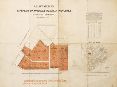
Map - Allotments Extension of Mildura-Merbein Mid-Area, Allotments available, 23 November 1920
... Photo-Lithographed at Department of lands Survey, Melbourne J. Butson 23.11.20...Merbein District Historical Society 36 Box St Merbein the-murray Allotments available to Discharged Soldiers Discharged Soldier's Settlement Act Historic Discharged Soldiers WW1 Soldier Settlement Irrigation Photo-Lithographed at Department of lands Survey, Melbourne J. Butson 23.11.20 Large map, folded in 4, coloured map of Merbein indicating allotments available and locality plan. ...Allotments available to Discharged Soldiers Discharged Soldier's Settlement Act Historic Large map, folded in 4, coloured map of Merbein indicating allotments available and locality plan. Scale 10 chain to 1 inchPhoto-Lithographed at Department of lands Survey, Melbourne J. Butson 23.11.20discharged soldiers, ww1, soldier settlement, irrigation -
 Bacchus Marsh & District Historical Society
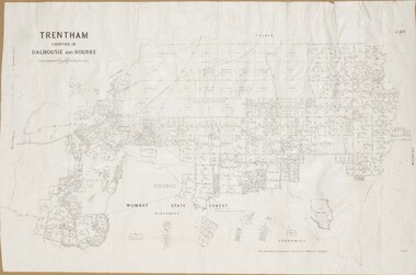
Map, Trentham Parish Map 1905 Copy 1
... Photo-lithographed at the Department of Lands and Survey, Melbourne by T.F. ...Bacchus Marsh & District Historical Society Lerderderg Library Main Street Bacchus Marsh Trentham Parish Maps Trentham Parish Plan Bacchus Marsh Region Parish Plans Photo-lithographed at the Department of Lands and Survey, Melbourne by T.F. ...A single page paper map showing the map for the Parish of Trentham in the Counties of Dalhousie and Bourke. A cadastral map showing parish boundaries and land ownership. The map is pasted into a bound volume containing 76 maps or plans in total. High resolution digital image stored on BMDHS computer network. Photo-lithographed at the Department of Lands and Survey, Melbourne by T.F. McGauran 22.3.05 trentham parish maps, trentham parish plan, bacchus marsh region parish plans -
 Bacchus Marsh & District Historical Society
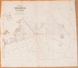
Map, Parish of Yangardook, County of Bourke 1876
... Photo lithographed at the Department of Lands and Survey, Melbourne by J. Noone, 1.8.76...Yangardook Parish Maps Toolern Vale Victoria Maps Photo lithographed at the Department of Lands and Survey, Melbourne by J. Noone, 1.8.76 A single page paper map showing the plan for the Parish of Yangardook in the in the County of Bourke. ...The parish of Yangardook lies directly north of the township of Melton. The locality of Toolern Vale lies in the centre of this parish. A single page paper map showing the plan for the Parish of Yangardook in the in the County of Bourke. Scale 40 chains to 1 inch. The map is pasted into a bound volume containing 76 maps or plans in total. High resolution digital image stored on BMDHS computer network. Photo lithographed at the Department of Lands and Survey, Melbourne by J. Noone, 1.8.76yangardook parish maps, toolern vale victoria maps -
 Bacchus Marsh & District Historical Society
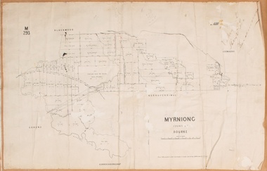
Map, Myrniong Parish Map, County of Bourke, 1882
... Photo-lithographed at the Department of Lands and Survey, Melbourne by J. Noone, 17.7.82...Bacchus Marsh & District Historical Society Lerderderg Library Main Street Bacchus Marsh Myrniong Parish Plan Myrniong Parish Maps Bacchus Marsh Region Parish Plans Photo-lithographed at the Department of Lands and Survey, Melbourne by J. Noone, 17.7.82 A single page paper map showing the map for the Parish of Myrniong in the County of Bourke. ...A single page paper map showing the map for the Parish of Myrniong in the County of Bourke. A cadastral map showing parish boundaries and land ownership. The map is pasted into a bound volume containing 76 maps or plans in total. High resolution digital image stored on BMDHS computer network. Photo-lithographed at the Department of Lands and Survey, Melbourne by J. Noone, 17.7.82myrniong parish plan, myrniong parish maps, bacchus marsh region parish plans -
 Bacchus Marsh & District Historical Society
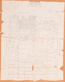
Map, Parwan Parish Map, County of Grant, 1909
... Photo-lithographed at the Department of Lands and Survey, Melbourne by T.F. ...Bacchus Marsh & District Historical Society Lerderderg Library Main Street Bacchus Marsh Bacchus Marsh Region Parish Plans Parwan Parish Maps Parwan Parish Plan Photo-lithographed at the Department of Lands and Survey, Melbourne by T.F. ...A single page paper map showing the map for the Parish of Parwan in the County of Grant. A cadastral map showing parish boundaries and land ownership. The map is pasted into a bound volume containing 76 maps or plans in total. High resolution digital image stored on BMDHS computer network. Photo-lithographed at the Department of Lands and Survey, Melbourne by T.F. McGauran, 7.7.09. bacchus marsh region parish plans, parwan parish maps, parwan parish plan