Showing 7 items matching "diggora"
-
 Bendigo Historical Society Inc.
Map - DIGGORA, 7/03/1892
... DIGGORA......Diggora...Map: Parish of Diggora, County of Bendigo. Parish plan (number 341 in map cupboard 1)...History House 11 Mackenzie Street Bendigo goldfields MAP Bendigo parish plan Diggora Map: Parish of Diggora, County of Bendigo. ...Map: Parish of Diggora, County of Bendigo. Parish plan (number 341 in map cupboard 1)map, bendigo, parish plan, diggora -
 Bendigo Historical Society Inc.
Newspaper - JENNY FOLEY COLLECTION: WINNING PAIR
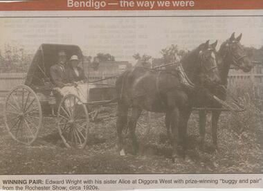
... Winning pair: Edward Wright and his sister Alice at Diggora West with prize-winning ''buggy and pair'' from the Rochester Show; circa 1920s. ...Winning pair: Edward Wright and his sister Alice at Diggora West with prize-winning ''buggy and pair'' from the Rochester Show; circa 1920s. ...Bendigo Advertiser ''The way we were'' from 2001. Winning pair: Edward Wright and his sister Alice at Diggora West with prize-winning ''buggy and pair'' from the Rochester Show; circa 1920s. The clip is in a folder.newspaper, bendigo advertiser, the way we were -
 Bendigo Historical Society Inc.
Newspaper - JENNY FOLEY COLLECTION: THE BIG DAY
... The big day: Joseph Wright, from Diggora West, and Ann Coutts, from Eaglehawk, who were married at Eaglehawk Presbyterian Church on September 9, 1922....The big day: Joseph Wright, from Diggora West, and Ann Coutts, from Eaglehawk, who were married at Eaglehawk Presbyterian Church on September 9, 1922. ...Bendigo Advertiser ''The way we were'' from Friday, December 10, 2004. The big day: Joseph Wright, from Diggora West, and Ann Coutts, from Eaglehawk, who were married at Eaglehawk Presbyterian Church on September 9, 1922.newspaper, bendigo advertiser, the way we were -
 Bendigo Historical Society Inc.
Newspaper - JENNY FOLEY COLLECTION: TOGETHER
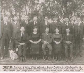
... Together: the family of James Wright gathered at Diggora West the day of his funeral in 1924. ...Together: the family of James Wright gathered at Diggora West the day of his funeral in 1924. ...Bendigo Advertiser "The way we were" from Tuesday,July 27, 2004. Together: the family of James Wright gathered at Diggora West the day of his funeral in 1924. Wright came across from England to settle in the area in 1876. Back row from left: Frederick, Joseph, Arthur, Edward, Cecil, George, Samuel, James. Front row: William, Ruby, Charles, Alice, Alfred.newspaper, bendigo advertiser, the way we were -
 Bendigo Historical Society Inc.
Newspaper - JENNY FOLEY COLLECTION: PREMIERS
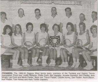
... Premiers: the 1968/69 Diggora West tennis team, premiers of the Tandara and District Tennis Association. ...Premiers: the 1968/69 Diggora West tennis team, premiers of the Tandara and District Tennis Association. ...Bendigo Advertiser "The way we were" from 2004. Premiers: the 1968/69 Diggora West tennis team, premiers of the Tandara and District Tennis Association. Front row: Judith Williams, Phillis Coch, Bev Appleby, Annette Brereton, Ann Fiedler, Avis Wright, Lex Coch and Merle Fiedler. Back row: Trevor Fiedler, Claude Honey, Des Fiedler, Norm Bacon, Ken Fiedler, Tom Honey and Herb Tonkin (captain).newspaper, bendigo advertiser, the way we were -
 City of Greater Bendigo - Civic Collection
Ceremonial object - Shire of Huntly Medallion
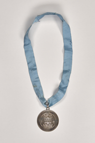
... The shire’s south-west corner adjoined Epsom (Bendigo), its eastern boundary was the Campaspe River and its northern boundary ran through Diggora West. Its area was 878 sq km, unchanged since the shire was created. ...The shire’s south-west corner adjoined Epsom (Bendigo), its eastern boundary was the Campaspe River and its northern boundary ran through Diggora West. Its area was 878 sq km, unchanged since the shire was created. ...Huntly Shire (1866-1994), north of Bendigo, was proclaimed on 13 July 1866, the successor to a road district which had been created in 1861. It was named after the Huntly parish (1854) which was probably named after Huntly, Aberdeenshire, Scotland. The shire’s south-west corner adjoined Epsom (Bendigo), its eastern boundary was the Campaspe River and its northern boundary ran through Diggora West. Its area was 878 sq km, unchanged since the shire was created. The administrative centre of the shire was Huntly, nearly on the edge of Bendigo’s urban fringe. In the south of the shire there were former gold mining areas at Huntly, Fosterville and Bagshot. The Midland Highway and railway line (1864) running north-east through the shire connected Goornong and Elmore to Bendigo. Elmore was the shire’s largest town, situated in a wheat/sheep farming area. The Kamerooka State Park was in the north-west of the shire. It was amalgamated with Bendigo, Marong, Eaglehawk and Strathfieldsaye in 1994 and is now part of the City of Greater Bendigo.Shire of Huntly stirling silver hand engraved drop suspended from a ling blue masonic ribbon. Front; SHIRE OF HUNGLY / 1886 / UNITA FORTIOR. Verso; PRESENTED TO THE SHIRE OF HUNTLY / BY CR. THE HON. M. A. CLARKE / 12TH AUGUST 1981shire of huntly, city of greater bendigo ceremonial item -
 Bendigo Historical Society Inc.
Newspaper - Newspaper articles by Ken Arnold, Out &About, 2000 - 2003
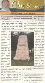
... Fish Point, Benjeroop North 17.5.02 92. Old Township. Diggora 24.5.02 93. Diggora West (1) 31.5.02 94. ...Fish Point, Benjeroop North 17.5.02 92. Old Township. Diggora 24.5.02 93. Diggora West (1) 31.5.02 94. ...Ken Arnold is a Bendigo author and publisher.A series of one hundred and thirty-five articles written by Ken Arnold and published in the Bendigo Weekly between 2000 and 2003. Each article has a topic or theme and includes historical information and details. Each article includes a photograph. The articles are stored in a red vinyl covered two ring A5 folder. Index below. Number Article Name Date 1. Centenary of Victoria 19.5.00 2. Storm Water Drain 26.5.00 3. Granite Rollers 2.6.00 4. Poverty Mine 9.6.00 5. Golden Monument. St Arnaud 16.6.00 6. Turner Statue 7.7.00 7. Gold Monument. High St Golden Square 30.6.00 8. Gold Monument. Howard Square Bendigo 14.7.00 9. Lansell Statue 21.7.00 10. Shelbourne West School 18.8.00 11. Mologa’s State Schools 25.8.00 12. Salinity Stone. Pyramid Hill 1.9.00 13. Cairn. Carisbrook 8.9.00 14. Commemorative Markers. Taradale 15.9.00 15. Burke Monument. Castlemaine 22.9.00 16. Cairn. Harcourt area 29.9.00 17. Cairn Marks Gold Route 6.10.00 18. Volcanic Rock Cairn. Woodstock 13.10.00 19. Garfield Water Wheel 20.10.00 20. Anticline. Castlemaine 27.10.00 21. Lawson Bridge 10.11.00 22. Plaque. Sutton Grange area 17.11.00 23. Memorial Cairn. Maryborough 1.12.00 24. Lonely Grave 8.12.00 25. Moonlight Flat Church 5.1.01 26. Historic Church. Near Tullaroop reservoir 12.1.01 27. Granite Statue. Castlemaine 19.1.01 28. Marker. Near Tullaroop reservoir 25.1.01 29. Church Site. Mologa 2.2.01 30. Church Site. Mologa 9.2.01 31. Plaque. Mologa 16.2.01 32. Mincha School 23.2.01 33. Historic Marker. Mincha 2.3.01 34. Expedition Marker. Pyramid Hill 9.3.01 35. Irrigation Marker. Tragowel 16.3.01 36. Mologa School Sites 23.3.01 37. Cairn. Pyramid Hill 30.3.01 38. Plaque. Pyramid Hill 6.4.01 39. Bristol Hill Lookout Tower. Maryborough 12.4.01 40. Eppalock Reservoir 20.4.01 41. Colbinabbin Cairn 27.4.01 42. Mount Macedon Cross 4.5.01 43. Memorial Gateway. Macedon 11.5.01 44. Cairn. Daylesford 18.5.01 45. Grave. Carlsruhe 25.5.01 46. Water Tower. Elmore 1.6.01 47. State School Site. Glenalbyn 8.6.01 48. Cairn. Kanya 15.6.01 49. Lonely Grave. Wedderburn 22.6.01 50. Church Cairn. Glenalbyn 29.6.01 51. Kamarooka School 6.7.01 52. Granite Marker. Moyston 13.7.01 53. Memorial Park. Kerang 20.7.01 54. Water Plaque. Bears Lagoon 27.7.01 55. Cemetery. Bears Lagoon 3.8.01 56. Race Monument 10.8.01 57. Cairn. Pyalong 17.8.01 58. Cairn. In memory of Edward Parker 24.8.01 59. Mt Macedon 31.8.01 60. Mt Macedon Cairn 7.9.01 61. Expedition Pass. Chewton 14.9.01 62. Granite Archway. St Arnaud 21.9.01 63. Stuart Mill School Site 28.9.01 64. School Site. Beazley’s Bridge 5.10.01 65. Fosterville 12.10.01 66. Barnadown 19.10.01 67. Salisbury School Site 26.10.01 68. Cricket History at Wattle Flat 2.11.01 69. School Site. Waterloo Plains 9.11.01 70. Carapooee School Site 11.01 71. Turkish Gun. Maldon 11.01 72. Kooreh 30.11.01 73. Marnoo East School 7.12.01 74. Bulgana Site 14.12.01 75. Emu School 21.12.01 76. Kooroocheang 4.1.02 77. Church Site. Gre Gre North 11.1.02 78. Carmens Tunnel. Maldon 18.1.02 79. Monument. Maldon 25.1.02 80. Woodfull Plaques. Maldon 1.2.02 81. Carapooee. St Peters Anglican Church 8.2.02 82. Cairn. Kingower 15.2.02 83. Cob & Co Stopover. Rheola 22.2.02 84. Flynn Monument 1.3.02 85. The Welcome Stranger. Moliagul 8.3.02 86. Campbell’s Creek Reserve 15.3.02 87. Mine. Fryerstown 22.3.02 88. Escott Grave. Near Chewton 28.3.02 89. School No 808. Kurting area 5.4.02 90. Graves. Bendigo Creek 10.5.02 91. School. Fish Point, Benjeroop North 17.5.02 92. Old Township. Diggora 24.5.02 93. Diggora West (1) 31.5.02 94. Diggora West (2) 7.6.02 95. School No 2735. Gower East 14.6.02 96. Pannoomilloo 21.6.02 97. Kamarooka Settlement 28.6.02 98. Mincha West State School No 1931 5.7.02 99. Bridges. Arnold 12.7.02 100. Woodvale 19.7.02 101. A Famous Son of Raywood. Jack Donaldson 26.7.02 102. Tandarra Area Schools 2.8.02 103. Dingee 9.8.02 104. Avonmore 30.8.02 105. Myola East School 6.9.02 106. Colbinabbin West 13.9.02 107. Colbinabbin West School 20.9.02 108. Runnymede area 27.9.02 109. Wanalta 4.10.02 110. School Sites. Between Wanalta and Carop 11.10.02 111. Burramboot 18.10.02 112. Kangaroo Chair. 25.10.02 113. Mincha South 1.11.02 114. Woodlands Church 8.11.02 115. School site. Sylvaterre 15.11.02 116. Terrick Terrick 22.11.02 117. Leitchville 29.11.02 118. Pennyweight Cemetery. Castlemaine 6.12.02 119. Mincha Area 13.12.02 120. Musk School 20.12.02 121. Dowie Park. Carisbrook 3.1.03 122. Neereman School Site 10.1.03 123. Bald Rock 17.1.03 124. Sylvaterre School Site 24.1.02 125. Carlsruhe 31.1.02 126. Athenaeum. Maldon 7.2.03 127. School. Mincha West 14.2.03 128. Yarraberb 21.2.03 129. Settlement Marker. Ravenswood Estate 28.2.03 130. Comini Reserve. Ravenswood 7.3.03 131. Ironbark and Gold Track. Whroo 14.3.03 132. Burke and Wills Obelisk. Castlemaine 21.3.03 133. James Cook Statue. Myers St Bendigo 28.3.03 134. St Marys Church. Axedale 4 .4.03 135. Butter Factory Site. Warragamba 11.4.03 events, monuments, historical sites, landmarks