Showing 38718 items matching documents-maps
-
 Greensborough Historical Society
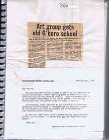
Folder, Greensborough Primary School Gr2062 Documents, 20/10/1988
... Greensborough Primary School Gr2062 Documents ...Documents relate to Greensborough Primary School 2062, 1969-1988, including the use of the old brick building for community purposes.Much of the brick building dates from 1878, and has been threatened with demolition at times.Folder containing miscellaneous documents and newspaper clippings.greensborough primary school -
 Koorie Heritage Trust
Book, Alberts, Trish et al, Making a Difference / First Australians : Plenty Stories, 2010
... ., col. maps, ports. (some col.) ; 24 cm. ...This book shares inspiring stories aabout how individuals and organisations have made a difference in Australian society by giving a voice to the histories and viewpoints of Aboriginal and Torres Strait Islander peoples. Contents: Understanding each other; Koorie Heritage Trust; Bangarra Dance Theatre; The Aboriginal Baldja Network; Reconciliation Australia and the Stolen Generations Alliance; Working together for change; Glossary; Index.32 p. : ill., col. maps, ports. (some col.) ; 24 cm.This book shares inspiring stories aabout how individuals and organisations have made a difference in Australian society by giving a voice to the histories and viewpoints of Aboriginal and Torres Strait Islander peoples. Contents: Understanding each other; Koorie Heritage Trust; Bangarra Dance Theatre; The Aboriginal Baldja Network; Reconciliation Australia and the Stolen Generations Alliance; Working together for change; Glossary; Index.aboriginal australians. | torres strait islanders. | australian -
 Melbourne Tram Museum
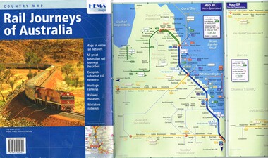
Map, HEMA Maps, "Rail Journeys of Australia", 2011
... Maps...HEMA Maps ...Map - 16 fold full colour gloss paper titled "Rail Journeys of Australia", published 2011m diagrammatic maps of the Australian rail network, complete suburban rail and tram networks, heritage railways, railway museums and miniature railways. Has a photo of The Ghan on the front. Published by HEMA Maps. Includes a combined diagrammatic map of Melbourne suburban railway and tramways and ferries. Has a note on the frequency and fares. Received during 2011 as a with compliments slip and asking if needed more. Slip gives the publishers details.trams, tramways, maps, australian railways, trams, melbourne -
 Bendigo Military Museum
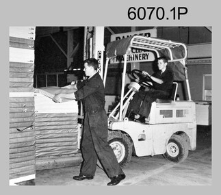
Photograph - Maps despatched by Printer Technicians at the Army Survey Regiment, c1970s to c1990s
... Maps despatched by Printer Technicians at the Army Survey ...These nine photographs of Printer Technicians working on the despatch of bulk printed map stock to customers, were probably taken circa 1970s to 1990s in Lithographic Squadron at the Army Survey Regiment, Fortuna, Bendigo. Except for photo .3P, personnel are not annotated on the photos. Despatch was the final task performed by a team of Printer Technicians. It involved the wrapping of trimmed bulk maps into manageable parcels and sending them by freight to customers or to the Army Map Depot at Bandiana, VIC. The task’s Due date and sensitivity were essential considerations in the planning of production affecting the lead time and method of delivery. Freighting by commercial means was the normal method for routine tasks. The method of despatch for urgent time-critical tasks sometimes meant having to use military freight or safe-handed by Army Survey Regiment personnel. The mishap captured in photos .6P and .7P was rare, but costly if it was a time critical task. The Print Room’s Map Handling Station in photos .8P and .9P provided ergonomic benefits to the Printer Technician and improved despatch productivity.This is a set of photographs of Printer Technicians involved in the despatch of bulk printed map stock c1970s to c1990s. The photographs were printed on photographic paper and are part of the Army Survey Regiment’s Collection. The photographs were scanned at 300 dpi. .1) - Photo, black & white, c1970s, L to R: unidentified, unidentified, Lithographic Squadron .2) - Photo, black & white, c1980s, Steve Egan, Lithographic Squadron .3) - Photo, black & white, c1980s, L to R: unidentified, Kim Reynolds, Lithographic Squadron .4) - Photo, colour, c1980s, L to R: Jeff Willey, Gary Kerr, Lithographic Squadron .5) - Photo, black & white, c1980s, L to R: Jim Ash, Mark ‘Dogs’ Doherty, Stuart Ridge, Lithographic Squadron .6) - Photo, colour, c1980s, printed maps toppled, Lithographic Squadron .7) - Photo, colour, c1980s, printed maps toppled, Lithographic Squadron .8) - Photo, black & white, c1990s, L to R: unidentified, unidentified, Lithographic Squadron .9) - Photo, black & white, c1990s, unidentified, Lithographic Squadron .3P, personnel annotation on back. .1P, .2P, .4P, .5P, .8P and .9P – no personnel annotated .6P and .7P – ‘Good one Daryl’ annotated on back.royal australian survey corps, rasvy, army survey regiment, army svy regt, fortuna, asr, litho, printing -
Clunes Museum
Pamphlet, Wilkins Tourist Maps
... Wilkins Tourist Maps ...Colour Clunes area map outlining day tours around Clunes and surrounds with points of interest.tourist map, day tours of clunes -
 NMIT (Northern Melbourne Institute of TAFE)
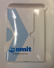
Folder - NMIT, Policy documents - Human Resources, 2005-2007
... Policy documents - Human Resources ...A collection of policies and sample documents relating to all aspects of Human Resources.Shows NMIT Human Resources policies as they were in 2005-2007.A corporate folder, white with blue nmit name and logo. Contains copies of policy documents.employment, human resources, nmit, -
Whitehorse Historical Society Inc.
Map, Directory Maps of the County of Bourke, 1892
... Directory Maps of the County of Bourke...Maps ...Copies of Directory maps:(i) Title Page, (ii) Preface (iii) Heading section of Map of Melbourne and Suburbs (iv) Parish of Bulleen - includes 'North - East portion of the Parish of Nunawading (v) Village of Burwood. Note: 107(a), 107(b), 107(c) are copies of the same set of sheets.Copies of:(i) Title Page, (ii) Preface (iii) Heading section of Map of Melbourne and Suburbs (iv) Parish of Bulleen - includes 'North - East portion of the Parish of Nunawading (v) Village of Burwood. Note: 107(a), 107(b), 107(c) are copies of the same set of sheets.Copies of Directory maps:(i) Title Page, (ii) Preface (iii) Heading section of Map of Melbourne and Suburbs (iv) Parish of Bulleen - includes 'North - East portion of the Parish of Nunawading (v) Village of Burwood. Note: 107(a), 107(b), 107(c) are copies of the same set of sheets.maps, parish of bulleen, parish of nunawading, burwood -
 Ringwood RSL Sub-Branch
Map - Assorted maps around Australia, Maps
... Maps ...Australian maps -
Port Melbourne Historical & Preservation Society
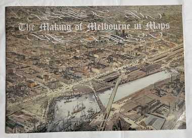
Book, Jeff Leeuwenburg, "The Making of Melbourne in Maps", 1987
... "The Making of Melbourne in Maps" ..."The Making of Melbourne in Maps" by Jeff Leeuwenburg (1987), includes maps of Melbourne from 1836 to 1930built environment, jeff leeuwenburg -
 Robin Boyd Foundation
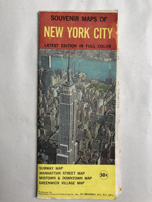
Map, Manhattan Postcard Publishing Co, Souvenir Maps of New York City
... Souvenir Maps of New York City ...Map of New Yorknew york city, map, walsh st library -
 Ringwood and District Historical Society
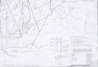
Map - Maps, Geological Map Donvale to Chirnside Park, also Victorian Railways Maps of Hawthorn to Lilydale Line incl Ringwood to East Ringwood - 1881
... Maps... Railways Maps of Hawthorn to Lilydale Line incl Ringwood to East ...Faint photocopies of sections of larger maps. Geological map includes location of mine shafts circa 1920.Victory Shaft, North Victory Shaft, South Caledonia Shaft, Caledonia Shaft, North Caledonia Shaft, Black Swan Shaft, Reward Shaft, Consols Shaft, Blocks Shaft, Devonshire Shaft, Crown Shaft, Yarra Tunnel Reef Working, Bright's Shaft, Kingwood Antimony Company Shaft (Boardman's Shaft), Southern Shaft. -
Ringwood and District Historical Society
Envelope, Packet: Maps of Ringwood from 1800s to late 1900s
... Packet: Maps of Ringwood from 1800s to late 1900s. ...History 1974; Maps of Ringwood -
 The Beechworth Burke Museum
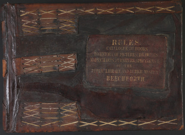
Book - 1875 Catalogue, William Detmold, RULES / CATALOGUE OF BOOKS / INVENTORY OF PICTURES, DRAWINGS, / MAPS, CHARTS, FURNITURE, SPECIMENS / OF THE / PUBLIC LIBRARY AND BURKE MUSEUM / BEECHWORTH, 1875
... , DRAWINGS, / MAPS, CHARTS, FURNITURE, SPECIMENS / OF THE / PUBLIC ...This large, leather bound journal was made for the Public Library and Burke Museum in Beechworth by book manufacturer, William Detmold in 1875. It was commissioned by the President of the Library and Burke Museum committee, Dr Antoine Mousse, for the purpose of cataloguing all the items in the collection. The cataloguer was the curator at that time, William Morton, whose hand-writing appears in the journal today. When William Morton first started recording in this journal in 1875, there were already a number of existing items in the institution. The Public Library and Burke Museum in Beechworth had actually been operating since the 1850s; first as a Young Men’s Association in 1856, then as Beechworth Athenaeum in 1858, then as the Beechworth Public Library in 1860. Then in 1861 when news of the death of Beechworth’s former police superintended, Robert O’Hara Burke, reached the town, it was agreed that the Public Library would also become a museum to tribute his legacy, renaming it as the ‘Public Library and Robert O’Hara Burke Memorial Museum, Beechworth’. Many of the items from the early institutions would have been used to form the nucleus of this new organisation. Plus, the additional items that were either collected or donated to develop it into a museum. The catalogue is extensive. There are exactly 461 pages of recorded items, each page detailing the various collections the museum acquired in the late 19th century. Collections recorded in this catalogue include a large collection of geological specimens, that were given to the museum in 1868 by the Geological Survey Department of Victoria. A large collection of taxidermy mounts, that were given to the museum as skins by the Museum of Australia in 1865. An extensive collection of Aboriginal artefacts that were purchased from amateur anthropologist R. E . Johns in 1868. As well as artworks, charts, photographs, machinery, maps etc., all of which have been held in the museum since. This catalogue also details the governance and management of the organisation. There were originally 30 rules that governed the actions for the management committee and, while anyone could read in the free library, only subscribers could borrow two books and one periodical. At first, subscriptions rates were 7/6 a quarter. This was later changed to £1 per annum, paid quarterly in advance. This was a considerable amount; 7/6 per quarter meant that the annual fee was £1.10. This was equivalent to about £650.00 or about $1,182.00AUD today, while the reduced subscription fee of £1 a year was the equivalent to £450.00 or about $818.00AUD today. Membership of the athenaeum would have been the reserve of the town's notable citizens. The vale of the catalogue lies not only in its historical connect with the establishment of the Athenaeum and the current museum, but also in its record of the names and positions of all members of the institution's committees of management from 1875-1876. This is a unique object that contains important records for a notable country town. Large brown leather bound book made in 1875 for the Beechworth library and museum by William Detmond. Inside is a comprehensive and detailed itemised listing of the paintings, drawings, charts, photographs, specimens and books that entered the institution from 1850 -1882. non-fictionCover: RULES / CATALOGUE OF BOOKS / INVENTORY OF PICTURES, DRAWINGS, / MAPS, CHARTS, FURNITURE, SPECIMENS / OF THE / PUBLIC LIBRARY AND BURKE MUSEUM / BEECHWORTHburke museum, beechworth, catalogue, museum catalogue, 1875, william morton, william detmold, exposition universelle, ferdinand von mueller, public library, collection, book, leather bound, restored, digitised, robert o'hara burke, hand-written -
 Greensborough Historical Society
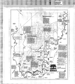
Map, Heidelberg: Historic River Landscape Assessment, Historical Maps. Map A To 1838. Country of the Wawarang, 1985c
... Maps. Map A To 1838. Country of the Wawarang ...Geographical area of around 35 sq. kilometres marked with physical features such as major roads, rivers, vegetation and properties, with contemporary notes on landowners, descriptions and comments on the land and its development. Bounded by Shire of Diamond Valley to the North, Darebin Creek to the West and Plenty River to the East.Black an white sketch map on white paperheidelberg, heidelberg - maps -
 Greensborough Historical Society
Map, Heidelberg: Historic River Landscape Assessment. Historical Maps. Map B 1838-1851, "The Distinctly aristocratic locality", 1985c
... Maps. Map B 1838-1851, "The Distinctly aristocratic locality" ...Geographical area of around 35 sq. kilometres marked with physical features such as major roads, rivers, vegetation and properties, with contemporary notes on landowners, descriptions and comments on the land and its development. Bounded by Shire of Diamond Valley to the North, Darebin Creek to the West and Plenty River to the EastBlack and white sketch map on white paperheidelberg, heidelberg - maps -
 Greensborough Historical Society
Map, Heidelberg. Historic River Landscape Assessment. Historical maps: Map C 1851-1863. "The Garden of the colony", 1985c
... maps: Map C 1851-1863. "The Garden of the colony" ...Geographical area of around 35 sq. kilometres marked with physical features such as major roads, vegetation and properties, with locations and notes of the increasing number of farms, gardens orchards and vineyards which had become established in addition to pastoral runs. Bounded by Shire of Diamond Valley to the North, Darebin Creek to the West and Plenty River to the East.Black and white sketch map on white paperheidelberg, heidelberg - maps -
 Greensborough Historical Society
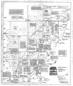
Map, Heidelberg: Historic River Landscape Assessment. Historical maps. Map E 1901-1934 "A Time of projects and improvements", 1985c
... maps. Map E 1901-1934 "A Time of projects and improvements" ...Geographical area of around 35 sq. kilometres marked with physical features such as major roads, railways (new extension to Eltham), rivers and properties, also housing sub-divisions and community facilities such as hospitals, parks and sporting reserves and indications of new small scale industries such as dairying. Bounded by Shire of Diamond Valley to the North, Darebin Creek to the West and Plenty River to the East. Black and white sketch map on white paperheidelberg, heidelberg - maps -
Ringwood and District Historical Society
Envelope, Packet: 4 maps Ringwood area c.1950
... Packet: 4 maps Ringwood area c.1950 ...4 maps Ringwood area c.1950 -
 Monbulk RSL Sub Branch
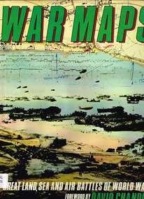
Book, McDonald, War maps, 1982
... War maps ...Maps of World War II campaigns from September 1939 to August 1945, air, sea and land, battle by battle.Index, bib, ill, maps, p.186.non-fictionMaps of World War II campaigns from September 1939 to August 1945, air, sea and land, battle by battle.world war 1939-1945 - maps, world war 1939-1945 - campaigns -
 Ringwood and District Historical Society
Document - Documents, Folder of miscellaneous documents of the Ringwood Arts Group 1968-1978, 1968-1978
... Documents...Folder of miscellaneous documents of the Ringwood Arts ...Part of the collected documents of the Ringwood Art group 1968-1978Red covered 2 ring binder with Tudor loose leaf refills containing miscellaneous documents, letters, accounts and the Constitution of the Ringwood Art and Craft Society between 1968-1978 -
 City of Moorabbin Historical Society (Operating the Box Cottage Museum)
Book, Leeuwenburg, Jeff, The making of Melbourne in maps, 1987
... The making of Melbourne in maps...maps ...Cartographic material.1 atlas (57 p.) : ill., chiefly maps ;Cartographic material.maps, melbourne -
University of Melbourne, Burnley Campus Archives
geological survey - Map, Maps of Geelong and Portarlington areas, 1963
... Maps of Geelong and Portarlington areas ...A. Coloured geological survey map of Geelong area: showing sedimentary and igneous rock formations and contours. B. Coloured geological survey map of Portarlington, Victoria. By Dept. Of Mines, Melbourne.geological survey, geelong, portarlington -
University of Melbourne, Burnley Campus Archives
Plan, Maplist: Catalogue of Victorian maps, 1984
... Maplist: Catalogue of Victorian maps ...Brochure showing all standard series mapping in Victoria available from Map Sales Centre as at October 1984. Includes: Geographic, Geological Planimetric, Aerial Photography, Photo Maps. -
Whitehorse Historical Society Inc.
Document, Historical maps and plans, 1855 1889
... Historical maps and plans...Maps ...Copy of catalogue of historical maps and plans - Crown Lands DepartmentCopy of catalogue of historical maps and plans - Crown Lands DepartmentCopy of catalogue of historical maps and plans - Crown Lands Departmentmaps, historical maps -
 Federation University Historical Collection
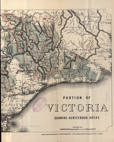
Map - Map and Information, Department of Mines: Map and Suggestions to Prospectors, 1891
The map outlines the auriferous (gold bearing) areas in Victoria. The information for prospectors was prepared by the Department of Mines in 1894Document: 4 page type written Map: Portion of Victoria divided into Counties of 1891. Auriferous areas with red.Reference section on mapgold, auriferous areas, department of mines, victoria, map of victoria, prospectors, commissioner of crown lands, hon a mclean, alexander black, surveyor general, a mclean -
 Robin Boyd Foundation
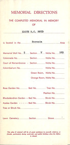
Document, Assorted documents, Jul-61
... Assorted documents ...Documentation for Wall Niche with cast bronze memorial plate for Edith Susan Gerard Boyd (16 Feb 1880 - 31 Mar 1961), Robin Boyd's mother at Springvale Cemetery - includes a location plan, invoice and receipts.5 documents -
Port Melbourne Historical & Preservation Society
Document - Photocopy, maps, 1890s maps, 30 April 1890 .01 11 March 1890 .02
... 1890s maps ....01 Copy of Map 3084B - Port Melbourne, Willamstown Road to Esplanade East; to Graham Street; to Boundary Road & Pickles Street. .02 Copy of map of Port Melbourne, Bay Street to Clark Street; to Foreshore; to Pickle Street & Spring Street..01 for title information see parcels index 47,53,54,55,56 & 57. .02 Parcels index 3084-B 16 (City of Port Melbourne)built environment - commercial, built environment - domestic, city of port melbourne, parish of south melbourne -
National Vietnam Veterans Museum (NVVM)
Manual, Australian Army: Miscellaneous documents
... Australian Army: Miscellaneous documents ...Artillery maintenance documentsaustralia - armed forces - service manuals -
 Melbourne Tram Museum
Ephemera - Tram Route Guides, Metlink, Set of 12 Metlink route maps, c2008?
... Set of 12 Metlink route maps ...Set of 12 Metlink route maps, DL, providing a line map with the major stops, roads, approx. times for each section, ticketing zones and on the rear, service frequency and information about Metcards. All the same front styles, but three different styles on rear. Possibly produced before the route maps at Reg item 2443, not dated. Route 3, 5, 6, 8, 16, 19, 57, 59, 64, 67, 72, 78, 79,trams, tramways, metlink, tram services, timetables, route 3, route 5, route 6, route 8, route 16, route 19, route 57, route 59, route 64, route 67, route 72, route 78, route 79 -
 Eltham District Historical Society Inc
Document - Folder, Maps of early Eltham Village Reserve, 1999
... Maps of early Eltham Village Reserve ...Various photocopies from maps relating to the Eltham Village reserve 1840s15 pagesharry gilham collection, eltham village reserve, map