Showing 481 items matching "driveway"
-
 Vision Australia
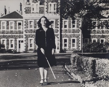
Photograph (item) - Image, Walking along RVIB driveway
... Walking along RVIB driveway...A young woman navigates her way along the driveway outside RVIB, keeping clear of the hedged garden border to her left....Black and white photograph of person using white cane on a driveway...Vision Australia 454 Glenferrie Road Kooyong melbourne A young woman navigates her way along the driveway outside RVIB, keeping clear of the hedged garden border to her left. royal victorian institute for the blind orientation and mobility Black and white photograph of person using white cane on a driveway Walking along RVIB driveway Photograph Image ...A young woman navigates her way along the driveway outside RVIB, keeping clear of the hedged garden border to her left.royal victorian institute for the blind, orientation and mobility -
 Federation University Historical Collection
Photograph - Black and White, Chatham-Holmes Collection: Lester's driveway, Ascot
... Chatham-Holmes Collection: Lester's driveway, Ascot......driveway...Lester's driveway plantation looking west. Now Lamley Nursery. ...Barker Library (top floor) Mount Helen goldfields chatham-holmes collection lester driveway ascot plantation lambley nursery Lester's driveway plantation looking west. ...Lester's driveway plantation looking west. Now Lamley Nursery. chatham-holmes collection, lester, driveway, ascot, plantation, lambley nursery -
 University of Melbourne, Burnley Campus Archives
Photograph - Black and white print, Driveway to Principal's Residence, 1947
... Driveway to Principal's Residence......driveway...Lily Ponds to the right of the driveway....Lily Ponds to the right of the driveway. Driveway to Principal's Residence Photograph Black and white print ...Appears as an illustration in, "Green Grows Our Garden, A.P. Winzenried p 77. Removed, after the Principals Residence was taken down, in 1980. "This narrow path replaced an earlier avenue which led up to the Curator's house (later Principal's Residence) . The avenue was lined with pine trees some of which survive." T.H. Kneen.Black and white photograph. Lily Ponds to the right of the driveway.On reverse, "Late Sept. 1947. Drive to house with pond & willows (pruned). Drive curves to left."lily ponds, driveway, green grows our garden, a.p. winzenried, principal's residence, luffmann ponds, pine trees -
 Department of Health and Human Services
Photograph, Colanda grounds main driveway
... Colanda grounds main driveway...Digitised colour photograph of the Colanda main driveway. ...Department of Health and Human Services 50 Lonsdale St Melbourne melbourne The Colac, Victoria-based Colanda Centre was one of the last Victorian institutions and offered disability accommodation from 1976, when it was established, until 2019, with its closure. colanda, colac, disability services, residential services, disability, digitised photograph Digitised colour photograph of the Colanda main driveway. Colanda grounds main driveway Photograph ...The Colac, Victoria-based Colanda Centre was one of the last Victorian institutions and offered disability accommodation from 1976, when it was established, until 2019, with its closure.Digitised colour photograph of the Colanda main driveway. colanda, colac, disability services, residential services, disability, digitised photograph -
 Department of Health and Human Services
Photograph, Colanda grounds - main driveway gardens
... Colanda grounds - main driveway gardens...Digitised colour photograph of Colanda's main driveway gardens. ...Department of Health and Human Services 50 Lonsdale St Melbourne melbourne The Colac, Victoria-based Colanda Centre was one of the last Victorian institutions and offered disability accommodation from 1976, when it was established, until 2019, with its closure. colanda, colac, disability services, residential services, disability, digitised photograph Digitised colour photograph of Colanda's main driveway gardens. Colanda grounds - main driveway gardens Photograph ...The Colac, Victoria-based Colanda Centre was one of the last Victorian institutions and offered disability accommodation from 1976, when it was established, until 2019, with its closure.Digitised colour photograph of Colanda's main driveway gardens. colanda, colac, disability services, residential services, disability, digitised photograph -
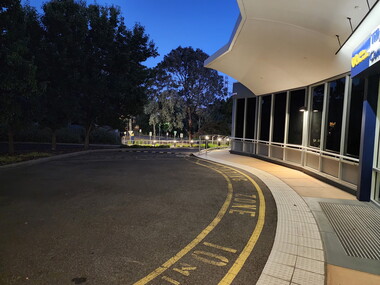 Vision Australia
Photograph (item) - Image, Jason Morgan, View of Glenferrie Road building from driveway, 22/02/2024
... View of Glenferrie Road building from driveway...View of Glenferrie Road building taken from driveway in early hours of the morning...Vision Australia Buildings John Wicking Janet Wicking View of Glenferrie Road building taken from driveway in early hours of the morning View of Glenferrie Road building from driveway Photograph Image Jason Morgan ...Photograph taken by a staff member of the main entry of the Kooyong building, with 'Wicking Centre' signage. vision australia, buildings, john wicking, janet wicking -
 Department of Health and Human Services
Photograph, Colanda Grounds - Exterior of Administration from main driveway
... Colanda Grounds - Exterior of Administration from main driveway...Digitised colour photograph of the exterior of Colanda's administration building from the main driveway. ...Department of Health and Human Services 50 Lonsdale St Melbourne melbourne The Colac, Victoria-based Colanda Centre was one of the last Victorian institutions and offered disability accommodation from 1976, when it was established, until 2019, with its closure. colanda, colac, disability services, residential services, disability, digitised photograph Digitised colour photograph of the exterior of Colanda's administration building from the main driveway. Colanda Grounds - Exterior of Administration from main driveway Photograph ...The Colac, Victoria-based Colanda Centre was one of the last Victorian institutions and offered disability accommodation from 1976, when it was established, until 2019, with its closure.Digitised colour photograph of the exterior of Colanda's administration building from the main driveway. colanda, colac, disability services, residential services, disability, digitised photograph -
 University of Melbourne, Burnley Campus Archives
Photograph - Black and white print, Main Entrance Driveway, July 1947
... Main Entrance Driveway......driveway...Main Entrance Driveway Photograph Black and white print E.M. ..."July 1947." E M Gibson. Entrance from Swan Street.5/3 331entrance, e. m. gibson collection, swan street entrance, driveway -
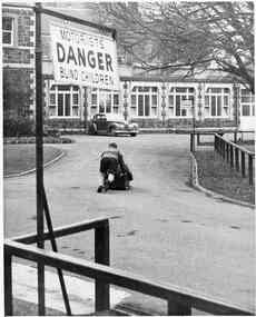 Vision Australia
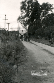
Photograph - Image, Two boys with a go cart in the driveway of RVIB in St Kilda Road, late 1940s
... Two boys with a go cart in the driveway of RVIB in St Kilda Road...Two schoolboys ride on a go cart along the driveway, towards the main entrance of RVIB. ...Vision Australia 454 Glenferrie Road Kooyong melbourne Two schoolboys ride on a go cart along the driveway, towards the main entrance of RVIB. ...Two schoolboys ride on a go cart along the driveway, towards the main entrance of RVIB. In the foreground is a sign 'Motorists Danger Blind Children'.1 BW photograph of 2 boys using a go cart royal victorian institute for the blind, buildings, education -
 Eltham District Historical Society Inc
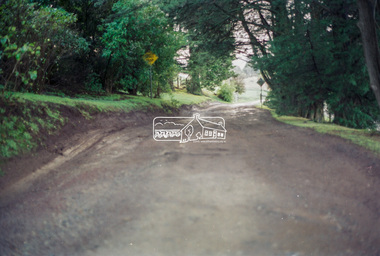
Negative - Photograph, Harry Gilham, Driveway, Memorial Park, Kangaroo Ground, Sep 2004
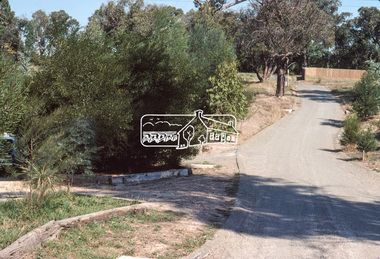
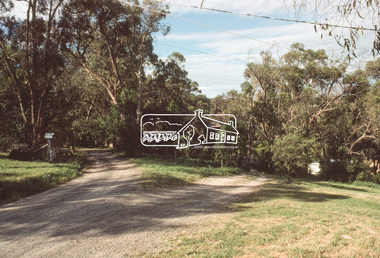
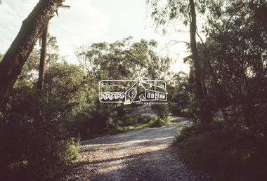
... Driveway, Memorial Park, Kangaroo Ground......Driveway...Eltham District Historical Society Inc 728 Main Rd Eltham melbourne Kangaroo Ground Tower Advisory Committee Notice Board Refurbishment Shire of Eltham Memorial Park Driveway Kangaroo Ground 35mm colour negative Kodak Gold 100-6 Single film strip, 1 of 4 frames Driveway, Memorial Park, Kangaroo Ground Negative Photograph Harry Gilham ...kangaroo ground tower advisory committee, notice board, refurbishment, shire of eltham memorial park, driveway, kangaroo ground -
 Stawell Historical Society Inc
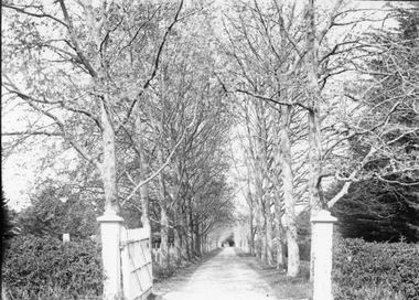
Photograph, “The Sycamores” Driveway entrance Gates
... “The Sycamores” Driveway entrance Gates...Entrance gates to “The Sycamores” Driveway. A show place on Concongella from mid 1860's. ...“The Sycamores” Driveway entrance Gates Photograph ...Entrance gates to “The Sycamores” Driveway. A show place on Concongella from mid 1860's. "The Sychmores" where William Osmand lived. Osmand's "Sycamores" was in a secluded block of the eastern side of the creek along which was planted pine and cypress trees. He built a comfortable house and line the carriage way with Sycamores. Osmand was on the of the men who made money in the Stawell reefs mines. "The Sycamores" has been owned by the West family since c 1920. Black & white photograph (2 copies) of an entrance gateway with an avenue of deciduous trees.concongella -
 Eltham District Historical Society Inc
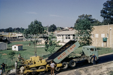
Photograph, Russell Yeoman, Asphalting Eltham Shire Office driveway at 895 Main Road, Eltham, c.1966
... Asphalting Eltham Shire Office driveway at 895 Main Road, Eltham...It is in fact a photo of sealing works on what was then the driveway for the Shire of Eltham Offices, present-day Library Place. ...It is in fact a photo of sealing works on what was then the driveway for the Shire of Eltham Offices, present-day Library Place. ...This picture was taken 1965/66. It is in fact a photo of sealing works on what was then the driveway for the Shire of Eltham Offices, present-day Library Place. The grassy area is where the Eltham Senior Citizen's Hall is located and the buildings are the rear of the Eltham War Memorial; on the far left being the Children's Library later War Memorial Hall (opened 11 Nov 1961), the Eltham Pre-school (opened 1 Dec 1956) and the Eltham Infant Welfare Centre (opened 15 Nov 1952).Digital file only; created from original colour positive slide transparencystreets, main road, eltham shire office, library place, russell yeoman collection -
 University of Melbourne, Burnley Campus Archives
Photograph - Black and white print, Series 3.9, 1942
... ...driveway...Principal's Driveway....University of Melbourne, Burnley Campus Archives 500 Yarra Boulevard Richmond melbourne Series 3 principals driveway james leslie provan j.l. provan Principal's Driveway. ...Series 3Principal's Driveway.principals, driveway, james leslie provan, j.l. provan -
University of Melbourne, Burnley Campus Archives
Photograph - Black and white print, Series 3.10, 1942
... ...driveway...Principal's Driveway....University of Melbourne, Burnley Campus Archives 500 Yarra Boulevard Richmond melbourne Series 3 principals driveway james leslie provan j.l. provan Principal's Driveway. ...Series 3Principal's Driveway.principals, driveway, james leslie provan, j.l. provan -
University of Melbourne, Burnley Campus Archives
Photograph - Black and white print, Series 4.33, 1943
... ...driveway...Principal's Driveway....University of Melbourne, Burnley Campus Archives 500 Yarra Boulevard Richmond melbourne Series 4 principals driveway james leslie provan j.l. provan Principal's Driveway. ...Series 4Principal's Driveway.principals, driveway, james leslie provan, j.l. provan -
 Eltham District Historical Society Inc
Photograph (Item) - Print, Jocelyn Zepter-Trevor, Their Driveway, 1988
... Their Driveway...It is a time capsule of life in the 1980s of this urban and rural municipality in Melbourne's north. shire of eltham archives Bicentennial Project Eltham Eltham Community Photographic Survey Eltham Photographic Survey Exhibition Series 34 Series 35 Film - Agfa XR 100 i Housing development Housing estate Jocelyn Zepter-Trevor Real Estate Development Scan - 35mm negative Front: Entrant No. and name on printed label Rear: Entrant No., name and address on printed label; also 'Series 34' and the 'Item No.' in pencil Colour print 20.5 x 25.5 cm mounted on card 25.4 x 30.4 cm Also corresponding negative (Series 35) Digital image scanned from negative (Series 35) Their Driveway Photograph Print Jocelyn Zepter-Trevor ...Jocelyn Zepter-Trevor 1988 Entrant No. 69 Ref: Series 34, Item 24 SHIRE OF ELTHAM COMMUNITY PHOTOGRAPHIC SURVEY Photography is an artform which many of us practice, sometimes purely for artistic pursuit, sometimes to record the people and events in our lives. In 1988, as part of a local Bicentennial project, the Shire of Eltham conducted the Eltham Community Photographic Survey. Up to 100 entries were to be selected by a panel of photographers for entry into the Eltham Photographic Survey Exhibition. Entries had to be submitted by May 13, 1988. Entrants whose images were selected for the exhibition were contacted and requested to further submit an entry form providing entrant’s name, area of residence, age, and proposed captions. These details were then used to produce labels for the exhibition mounts. Where negatives had not been supplied, these were requested to support the display of printed enlargements mounted on 10” x 8” cardboard. The mounted prints were made available post exhibition for sale at $8.50 each for colour prints and $7.00 for B&W prints. Residents in the Shire were invited to collect a free roll of film and take a photograph of what they either liked or did not like about the area. A total of 160 entrants submitted multiple entries for the exhibition. Of those selected for exhibition, entrants ranged in age from 9 to 70 years. All custom colour and black and white printing for the exhibition was completed by Wattle Studios of Eltham. The Eltham Photographic Survey was jointly auspiced by the Shire of Eltham and Wattle Studios, of 953 Main Road, Eltham. The project was greatly assisted by: • David McRitchie, Media Studies Lecturer Victoria College, Rusden Campus. • Ian and Annette Toohill of Wattle Studios • Tracy Naughton, Eltham Community Arts Officer • Neville Emerson Pty. Ltd. • Superior Press, Eltham • Kodak Australasia Pty. Ltd. • Agfa Gevaert Ltd. • Townsend Colourtech Pty. Ltd. • The Australian Bicentennial Authority • Eleanor Bowers, Secretary, Eltham Arts Council The exhibition was placed on display in the Woolworths Arcade, Eltham between Monday June 6th and Saturday June 11, 1988. It was also intended to hold the exhibition at a venue in the Shire’s North Riding from Monday, June 20 to Friday June 24. It was then displayed at the Were Street Theatre, Montmorency from Friday, June 24 to Thursday, July 7. Series 34: Eltham Community Photographic Survey 1988 - Prints & Documentation Series consists of 117 photographs of Shire scenes taken by members of the community. Items I - 41 are larger photographs mounted on card, which were exhibited. Items 42 - 117 are unmounted copies, alternative takes and other entries. Corresponding negatives contained in Series 35: Eltham Community Photographic Survey 1988 – Negatives which consists of 267 colour and B&W negatives and one colour slide of Shire scenes taken by members of the community. The negatives are arranged by the entrant number of the photographer. The Eltham Community Photographic Survey collection is significant to the local community as it was curated by the local community - ordinary people of all ages - representing what they liked and did not like in the area where they lived. It represents an unfiltered representation of the Shire of Eltham as it was in 1988. It also represents one of many projects as part of the national programme of events and celebrations to commemorate the bicentenary. It is a time capsule of life in the 1980s of this urban and rural municipality in Melbourne's north. Front: Entrant No. and name on printed label Rear: Entrant No., name and address on printed label; also 'Series 34' and the 'Item No.' in pencilshire of eltham archives, bicentennial project, eltham, eltham community photographic survey, eltham photographic survey exhibition, series 34, series 35, film - agfa xr 100 i, housing development, housing estate, jocelyn zepter-trevor, real estate development, scan - 35mm negative -
![Photograph - Digital Image, 10-12 Poulter Avenue [down driveway], 2015_](/media/collectors/4f729f5697f83e03086015b8/items/581981d0d0cdd11ed40d3450/item-media/581981ffd0cdd11ed40d4a3f/item-fit-380x285.jpg?cb=6) Greensborough Historical Society
Greensborough Historical SocietyPhotograph - Digital Image, 10-12 Poulter Avenue [down driveway], 2015_
... 10-12 Poulter Avenue [down driveway]...Digital copy of colour photograph. 10-12 Poulter Avenue [down driveway] Photograph - Digital Image ...Built circa 1930s this timber house has 6 rooms and fronts Poulter Avenue Greensborough. It was for sale in 2015 and photographs were taken by a GHS member.These older home sites are being redeveloped and photos give some idea of how Greensborough looked in the early 20th century.Digital copy of colour photograph. -
![Photograph - Digital Image, 10-12 Poulter Avenue [up the driveway], 2015_](/media/collectors/4f729f5697f83e03086015b8/items/58198386d0cdd11ed40e79a9/item-media/58198431d0cdd11ed40ef90b/item-fit-380x285.jpg?cb=6) Greensborough Historical Society
Greensborough Historical SocietyPhotograph - Digital Image, 10-12 Poulter Avenue [up the driveway], 2015_
... 10-12 Poulter Avenue [up the driveway]...Digital copy of colour photograph. 10-12 Poulter Avenue [up the driveway] Photograph - Digital Image ...Built circa 1930s this timber house has 6 rooms and fronts Poulter Avenue Greensborough. It was for sale in 2015 and photographs were taken by a GHS member.These older home sites are being redeveloped and photos give some idea of how Greensborough looked in the early 20th century.Digital copy of colour photograph. -
![Photograph - Digital Image, 14 Poulter Avenue [exterior, driveway], 24/07/2014](/media/collectors/4f729f5697f83e03086015b8/items/550905192162f1199c253c22/item-media/550905512162f1199c25402f/item-fit-380x285.jpg?cb=6) Greensborough Historical Society
Greensborough Historical SocietyPhotograph - Digital Image, 14 Poulter Avenue [exterior, driveway], 24/07/2014
... 14 Poulter Avenue [exterior, driveway]...Greensborough Historical Society 34A Glenauburn Road Lower Plenty Lower Plenty melbourne Built in the 1930s, the exterior of this property is in close to original condition. poulter avenue Digital copy of colour photograph. 14 Poulter Avenue [exterior, driveway] Photograph - Digital Image ...Built in the 1930s, the exterior of this property is in close to original condition.Digital copy of colour photograph.poulter avenue -
 Eltham District Historical Society Inc
Photograph, Looking northwest along Napier Crescent, Montmorency; standing in the driveway of number 21, 15 October 1990, 1990
... Looking northwest along Napier Crescent, Montmorency; standing in the driveway of number 21, 15 October 1990...Eltham District Historical Society Inc 728 Main Rd Eltham melbourne infrastructure, montmorency, napier crescent, shire of eltham, streets Kodak 5005 EPP Roll of 35mm colour positive film, 2 sequential frames including print copy Looking northwest along Napier Crescent, Montmorency; standing in the driveway of number 21, 15 October 1990 Photograph ...Roll of 35mm colour positive film, 2 sequential frames including print copy Kodak 5005 EPPinfrastructure, montmorency, napier crescent, shire of eltham, streets -
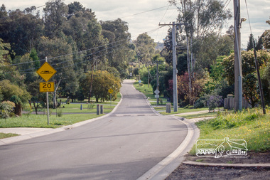
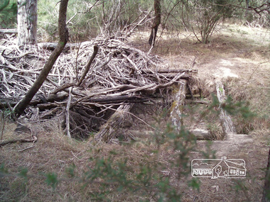 Eltham District Historical Society Inc
Photograph, Richard Pinn, Bridge on original driveway to Killeavey, Laughing Waters Road, Eltham, 2 May 2018, 2 May 2018
... Bridge on original driveway to Killeavey, Laughing Waters Road, Eltham, 2 May 2018...Eltham District Historical Society Inc 728 Main Rd Eltham melbourne Eltham, Killeavey, Laughing Waters Road Born digital image (qty 3) Bridge on original driveway to Killeavey, Laughing Waters Road, Eltham, 2 May 2018 Photograph Richard Pinn ...Born digital image (qty 3)eltham, killeavey, laughing waters road -
 Eltham District Historical Society Inc
Slide, Drainage under driveway near No. 10 Bolton Street, Lower Plenty, 18 July 1972, 1972
... Drainage under driveway near No. 10 Bolton Street, Lower Plenty, 18 July 1972...Eltham District Historical Society Inc 728 Main Rd Eltham melbourne Reconstruction works by Eltham Shire Council, Bolton Street, Eltham, 18 July 1972 bolton steet, eltham, eltham shire council, infrastructure, lower plenty, road construction, rosehill road 35 mm colour positive transparency Mount - Agfacolor Service (Blue) Drainage under driveway near No. 10 Bolton Street, Lower Plenty, 18 July 1972 Slide ...Reconstruction works by Eltham Shire Council, Bolton Street, Eltham, 18 July 197235 mm colour positive transparency Mount - Agfacolor Service (Blue)bolton steet, eltham, eltham shire council, infrastructure, lower plenty, road construction, rosehill road -
 Eltham District Historical Society Inc
Photograph, Driveway detail, Riverhill Drive, Lower Plenty, c.March 1981, 1981
... Driveway detail, Riverhill Drive, Lower Plenty, c.March 1981...Eltham District Historical Society Inc 728 Main Rd Eltham melbourne Infrastructure features used by Eltham Shire Council in the construction of Riverhill Drive, Lower Plenty, c.March 1981 infrastructure, lower plenty, riverhill drive, road construction, streets 35mm colour positive transparency Kodak Kodachrome cardboard mount Driveway detail, Riverhill Drive, Lower Plenty, c.March 1981 Photograph ...Infrastructure features used by Eltham Shire Council in the construction of Riverhill Drive, Lower Plenty, c.March 198135mm colour positive transparency Kodak Kodachrome cardboard mountinfrastructure, lower plenty, riverhill drive, road construction, streets -
 Eltham District Historical Society Inc
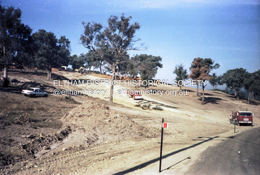
Slide, McCarthy Grove, Montmorency, extended driveway from Main Road, c.Oct. 1980
... McCarthy Grove, Montmorency, extended driveway from Main Road...They provide perspective of the changes in housing styles and road development that began sweeping in from the mid 1970s with increasing urbanisation of what was once more outlying suburbs and regions. houses infrastructure mccarthy grove montmorency roads Processed Oct 1980 35 mm colour positive transparency Mount - Kodak Kodachrome Card McCarthy Grove, Montmorency, extended driveway from Main Road Slide Slide ...One of a series of images of roads and infrastructure taken by Eltham Shire Council Planning and Engineering officers. They provide perspective of the changes in housing styles and road development that began sweeping in from the mid 1970s with increasing urbanisation of what was once more outlying suburbs and regions.35 mm colour positive transparency Mount - Kodak Kodachrome CardProcessed Oct 1980houses, infrastructure, mccarthy grove, montmorency, roads -
 Eltham District Historical Society Inc
Slide, Quinn Estate, McCarthy Grove ext. driveway, Montmorency, near no. 31, c.Oct. 1980
... Quinn Estate, McCarthy Grove ext. driveway, Montmorency, near no. 31...They provide perspective of the changes in housing styles and road development that began sweeping in from the mid 1970s with increasing urbanisation of what was once more outlying suburbs and regions. houses infrastructure mccarthy grove montmorency roads Processed Oct 1980 35 mm colour positive transparency Mount - Kodak Kodachrome Card Quinn Estate, McCarthy Grove ext. driveway, Montmorency, near no. 31 Slide Slide ...One of a series of images of roads and infrastructure taken by Eltham Shire Council Planning and Engineering officers. They provide perspective of the changes in housing styles and road development that began sweeping in from the mid 1970s with increasing urbanisation of what was once more outlying suburbs and regions.35 mm colour positive transparency Mount - Kodak Kodachrome CardProcessed Oct 1980houses, infrastructure, mccarthy grove, montmorency, roads -
 Eltham District Historical Society Inc
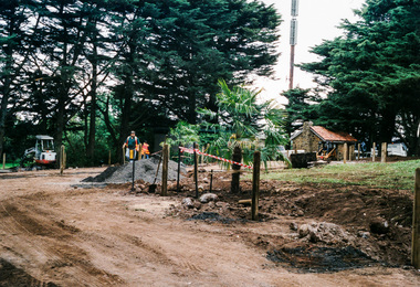
Photograph, Driveway refurbishment, War Memorial Tower, Kangaroo Ground
... Driveway refurbishment, War Memorial Tower, Kangaroo Ground...Photos subsequently relocated to photosafe archival storage.) [2001] kangaroo ground war memorial tower Colour photograph Driveway refurbishment, War Memorial Tower, Kangaroo Ground Photograph ...A replacement Windmill Palm in position (Photo contained in an album originally put together by Harry Gilham. Photos subsequently relocated to photosafe archival storage.) [2001]Colour photographkangaroo ground, war memorial tower -
 Eltham District Historical Society Inc
Photograph, Driveway of Eltham Living and Learning Centre
... Driveway of Eltham Living and Learning Centre...Eltham District Historical Society Inc 728 Main Rd Eltham melbourne eltham living and learning centre Black and white photograph (from proof sheet of 35mm contact prints) Driveway of Eltham Living and Learning Centre Photograph ...Black and white photograph (from proof sheet of 35mm contact prints)eltham living and learning centre -
 Eltham District Historical Society Inc
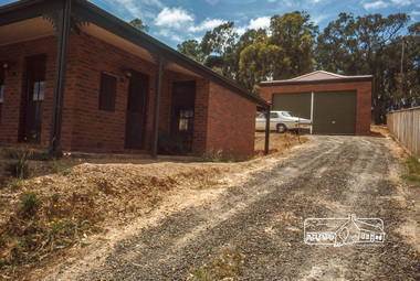
Photograph, Driveway, house and garage, January 1981
... Driveway, house and garage, January 1981...It was one of the earliest estates in Eltham following the nearby Woodridge Estate development. stokes place eltham stokes orchard stokes orchard estate streets houses peter and carla vermey Scanned by EDHS from 49 x 35mm colour transparencies provided on loan Digital file Driveway, house and garage, January 1981 Photograph ...14 Stokes Place (Lot 83) was the home of Peter and Carla Vermey. The land was purchased in May 1979 and construction commenced September 1979. The home was built by Peter and Carla Vermey after the developer, Macquarie Builders went bankrupt. Sold October 2017 by Morrison and Kleeman Real Estate. Stokes Place was part of the Stokes Orchard Estate which was developed from the break-up of the the orchard owned by Frank Stokes who lived on the northeast corner of Nyora Road and Eucalyptus Road. His daughter Beryl advised that the Shire had levied a rate assessment on individual parcels of land within the orchard which became unaffordable resulting in its sub-division and sell off. The Stokes Orchard Estate was developed by Macquarie Builders in two stages starting with stage 1 in 1976. Stokes Place was part of Stage 2 in 1979. The Estate was bounded between Nyora Road, Eucalyptus Road, Diosma Road and Stokes Place. The original orchard only just reached the left most portions of Stokes Place and did not go fully up to Diosma, rather to just beyond the extant of Stokes Place. Stokes Place was known within the family as "The Oats" as that is where they grew oats. Frank Stokes moved to Eltham c.1945 after visiting Harold Bird to view his orchard, located diagonally opposite Stokes Orchard from the intersection of Eucalyptus Road, Pitt Street and Nyora Road. It was on Harold Bird's recommendation that Frank purchased the land.The Stokes Orchard Estate collection is typical of housing developments of the late 1970s and 1980s. It was one of the earliest estates in Eltham following the nearby Woodridge Estate development.Digital fileScanned by EDHS from 49 x 35mm colour transparencies provided on loanstokes place, eltham, stokes orchard, stokes orchard estate, streets, houses, peter and carla vermey -
 Eltham District Historical Society Inc
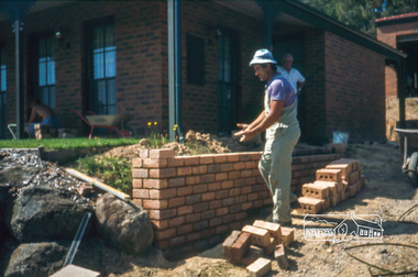
Photograph, Nick building brick wall along driveway, February 1982
... Nick building brick wall along driveway, February 1982...It was one of the earliest estates in Eltham following the nearby Woodridge Estate development. stokes place eltham stokes orchard stokes orchard estate streets houses peter and carla vermey Scanned by EDHS from 49 x 35mm colour transparencies provided on loan Digital file Nick building brick wall along driveway, February 1982 Photograph ...14 Stokes Place (Lot 83) was the home of Peter and Carla Vermey. The land was purchased in May 1979 and construction commenced September 1979. The home was built by Peter and Carla Vermey after the developer, Macquarie Builders went bankrupt. Sold October 2017 by Morrison and Kleeman Real Estate. Stokes Place was part of the Stokes Orchard Estate which was developed from the break-up of the the orchard owned by Frank Stokes who lived on the northeast corner of Nyora Road and Eucalyptus Road. His daughter Beryl advised that the Shire had levied a rate assessment on individual parcels of land within the orchard which became unaffordable resulting in its sub-division and sell off. The Stokes Orchard Estate was developed by Macquarie Builders in two stages starting with stage 1 in 1976. Stokes Place was part of Stage 2 in 1979. The Estate was bounded between Nyora Road, Eucalyptus Road, Diosma Road and Stokes Place. The original orchard only just reached the left most portions of Stokes Place and did not go fully up to Diosma, rather to just beyond the extant of Stokes Place. Stokes Place was known within the family as "The Oats" as that is where they grew oats. Frank Stokes moved to Eltham c.1945 after visiting Harold Bird to view his orchard, located diagonally opposite Stokes Orchard from the intersection of Eucalyptus Road, Pitt Street and Nyora Road. It was on Harold Bird's recommendation that Frank purchased the land.The Stokes Orchard Estate collection is typical of housing developments of the late 1970s and 1980s. It was one of the earliest estates in Eltham following the nearby Woodridge Estate development.Digital fileScanned by EDHS from 49 x 35mm colour transparencies provided on loanstokes place, eltham, stokes orchard, stokes orchard estate, streets, houses, peter and carla vermey