Showing 98 items matching dune
-
 Whitehorse Historical Society Inc.
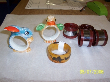
Domestic object - Serviette Ring
Part of|Mrs J. Lattins collection.Wooden serviette ring from Jerusalem featuring a camel and a man carrying something on his head with sand dunes in the distance.Jerusalemdomestic items, table setting -
 Federation University Historical Collection
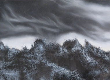
watercolor and gouache on paper, Sand Dunes, not dated
Black and white drawing of sand dunes. If you are able to provide information on this artist or artwork please use the comment link below. signed lower right "D. Cossar"artwork, sand dunes, drawing, asian, d. cossar -
 Port Fairy Historical Society Museum and Archives
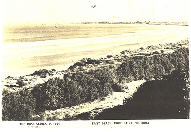
Postcard, The Rose Series / The Rose Stereographs, East Beach, Port Fairy Victoria
Black and white Photograph of East beach looking East South East with dunes in the foreground and the bay and Griffith Island in the background taken for use as a postcardThe Rose Series P.1144. Copyright East Beach Port Fairy Victoriaeast beach, dunes, sea, ocean, griffith island -
 Orbost & District Historical Society
black and white photograph, first half 20th century
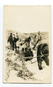
Access to the cottages at the lighthouse was difficult and the horse-drawn sled was in use until the 1940s. It was used to haul personal goods as wel as those needing medical attention at far-off Orbost. This photograph could be connected with the Gledhills in the 1930s when a medical emergency necessitated a removal to Orbost. Dr Nettleton was the doctor at Orbost at that time. (there could be a link through donor) Point Hicks is claimed to be Captain James Cook’s first sighting of mainland Australia. The lighthouse was built on the point during 1887 and 1888 and commenced operation in 1890, built from concrete and with timber keepers quarters. It was connected to mains electricity in 1965, and then to solar power recently. Originally access to Point Hicks was by sea. In 1920 a return trip, by land to Cann River, 47 kilometres away from the light station, took two days. By 1946 the journey had been reduced to 36 hours by a combination of horse and jeep. During the early 1950s it was still a 12-hour ordeal. The light no longer works, it was turned off 21 years ago and the Point Hicks lighthouse is now powered by a much smaller, more modern light. the lightkeepers' cottages are used for tourist accommodation.This photograph is associated with Point Hicks, a historically important lightstation in East Gippsland.A small black / white photograph of a horse dragging a sled with suitcases on it. There are seven people walking behind, one holding the reins. They are waalking through a sand dune.on label on back - "Bring Out to Light House keeper from Point Hicks"point-hicks-lighthouse -
 Phillip Island and District Historical Society Inc.
Photograph
Part of a collection presented by Miss Edith Elms via Chrisy Northcote.Westernport Bay at low tide showing line of low mangroves 1/3 from bottom. Brown foreground, low line of sand dunes in background.local history, photography, photographs, seascapes, westernport, coloured photograph, san remo -
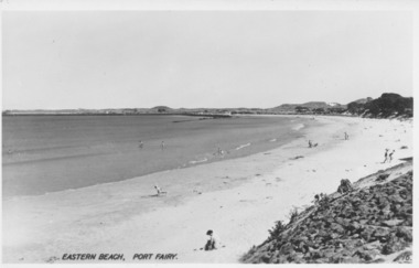 Port Fairy Historical Society Museum and Archives
Photograph, Valentine Publishing Co, Eastern Beach Port Fairy
Early view looking towards Griffiths Island showing the dunes with vegetation on themReflects change in coast over timeBlack and white photograph of curve of East BeachEastern Beach Port Fairy 16beach, sea, seascape, east beach -
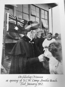 Phillip Island and District Historical Society Inc.
Photograph, Archbishop Mannix at YCW Camp, 2 January 1952
YCW is the acronym of the Young Catholic Workers. The camp is just back from the dunes.Large black & white photo mounted on cardboard of Archbishop Mannix, buiding, Australian flag and several peopleArchbishop Mannix at opening of YCW Camp, Smith's Beach,. 2 January 1952archbishop mannix, ycw camp, smiths beach, photographs -
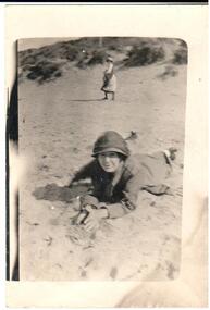 Hume City Civic Collection
Photograph, 1920s
A copy of a snapshot of a woman lying on the sand. She is wearing a hat and coat. Another woman is in the middle distance and is half turned towards the camera. There are sand dunes in the background.headwear, 1920s, george evans collection -
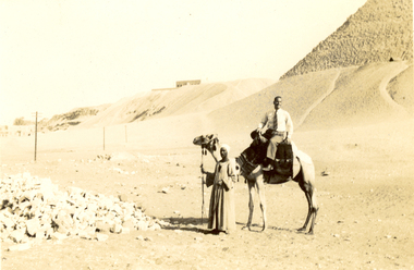 Federation University Historical Collection
Photograph - Black and White, Frank Wright at the Pyramids, 1940, May 1940
Frank Wright was a renown resident of Smeaton, where he was born. He lived at Laura Villa, and attended Smeaton State School. His father William was a gold miner and his mother's name was Sarah. Their family won many singing and instrumental awards. Frank was tutored by Percy Code and was awarded a gold medal for the highest marks in the ALCM examinations in the British Colonies at the age of seventeen years. He became the Australian Open Cornet Champion by the age of eighteen. A year later, Frank conducted the City of Ballarat Band, and later the Ballarat Soldiers’ Memorial Band. He formed the Frank Wright Frisco Band and Frank Wright and his Coliseum Orchestra. These bands won many South Street awards, and Frank as conductor won many awards in the Australian Band Championship contest. In 1933 Frank Wright sailed to England to conduct the famous St Hilda’s Band and was later appointed Musical Director of the London County Council, where he organized many amazing concerts in parks, in and around the London district. He was made Professor of Brass and Military Band Scoring and conducted at the Guildhall of Music and Drama. Frank was often invited to adjudicate Brass Band Championships around Europe, in Australia, including South Street and in New Zealand. The Frank Wright Medal at the Royal South Street competition is awarded to an individual recognized as making an outstanding contribution to brass music in Australia.Black and white photograph of a man sitting on a camel with the keeper standing at the camel's head. To the left is a pile of rocks and the rest of the background is sand rising to a dune and to the right is part of an Egyptian pyramid. The man is Frank Wright.Written in pencil on back - At the Pyramids, May 1940frank wright, egypt, pyramid, sand dune, camel -
 Glenelg Shire Council Cultural Collection
Photograph - Photograph - Aerial view of coastline around Portland, Victoria, c. 1954
Black and white aerial photograph of coastline around Portland. Black border, scale all sides, 5 rows of 3 't' at regular intervals. Top half is ocean, bottom half is ? beach; sand dunes, cliffs.Front: '607 - 61 ' - handwritten, white, border 'RUN 7 PORTLAND', printed, white, border -
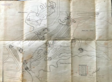 Phillip Island and District Historical Society Inc.
Map, Map of Summerland Golf Course, 15/12/1927
Summerlands Estate was created in the 1920s by A.K. T. Sampbell. It consisted of a housing estate, guest house and golf course. This area was acquired and all buildings, roads etc removed by the Victorian Government in the 1980s for a nature reserve for the penguins. This is believed to be the only time in the world when humans have been removed to benefit nature. HistoricalPurple leather covered fold out linen map with hand drawn diagram of the topography, layout of golf holes and club house Broken sand dunes, rough sandy hills, grassy hills and mounds, Swan Lake, Par for nine holes 34, Scratch score for nine holes 36, Drawn by A. Russell 12/12/1927summerland estate, summerlands golf course, a.k. t. sampbell, map, penguin reserve -
Glenelg Shire Council Cultural Collection
Magazine - Magazine Article, Australian Off-Road Action, c. 1981
Pages 15 - 26 of 'Australian Off-Road Action' magazine. White, black print and photographs. Pages 16 -26 is an article title 'Portland - the venue' documenting the history of the Portland Dune Buggy Club from its formation inv 1969 -
 Port Fairy Historical Society Museum and Archives
Photograph
East beach car park and sandColoured photograph of Expanse of East Beach from the car park people playing on sandeast beach, car park, sandcastle, caras, dune -
 Port Fairy Historical Society Museum and Archives
Photograph
East Beach Groyne wallseast beach, groyne, dune, sea, ocean -
 Port Fairy Historical Society Museum and Archives
Photograph
East Beach looking Southeast beach, norfolk pines, dune, ocean, sea -
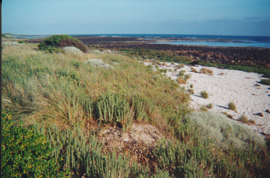
 Port Fairy Historical Society Museum and Archives
Photograph
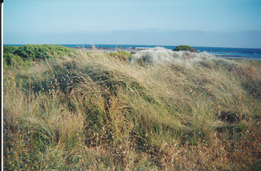
South Beach south beach, marram grass, dune, ocean, sea -
Glenelg Shire Council Cultural Collection
Photograph - Photograph - Bridgewater Hotel, Victoria, n.d
Black and white photo of the Bridgewater Hotel, front view. Double storey building, front verandah, tin roof, chimney each side of building. Three windows on first floor, window either side of door, ground floors, picket fence with gate; sand dunes behind.Back: 'BRIDGEWATER HOTEL' -printed in capitals, blue biro -
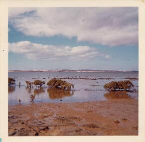
 Lake Bolac & District Historical Society
Colour photograph, Jan. Flood of Fiery Creek Inlet and Lake Bolac
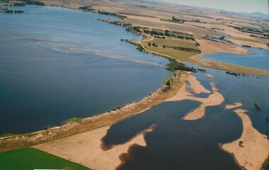
January, 2011. Floodwaters entering Lake Bolac through the Fiery Creek inlet. This shows the accumulation of water behind the barrier dunes and the strength of the flood entering the lake through the narrow debouchment. The aboriginal midden can clearly be seen in the front left to centre of the photograph. Photograph courtesy James Davidson.lake bolac, fiery creek, 2011 flood, midden -
 National Vietnam Veterans Museum (NVVM)
Photograph
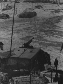
Denis Gibbons (1937 – 2011) Trained with the Australian Army, before travelling to Vietnam in January 1966, Denis stayed with the 1st Australian Task Force in Nui Dat working as a photographer. For almost five years Gibbons toured with nine Australian infantry battalions, posting compelling war images from within many combat zones before being flown out in late November 1970 after sustaining injuries. The images held within the National Vietnam Veterans Museum make up the Gibbons Collection.A black and white photograph of a quiet time, in a gun detachment area at an Australian Fire Support Base, in the sand dunes, on the coast, South East of the 1st Australian Task Force Base at Nui Dat, Phuoc Tuy Province, South Vietnam. The Battery was supporting Infantry in the area. (circa June 1970)photograph, fire support base, 1st atf base, nui dat, phuoc tuy province, infantry, gibbons collection catalogue, photographer, vietnam war, denis gibbons -
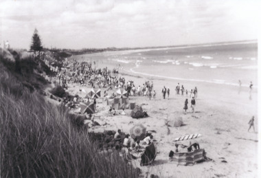 Port Fairy Historical Society Museum and Archives
Photograph
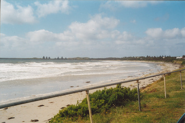
East Beach looking NorthBlack and white photograph of Crowds of people on East Beach east beach, north, people, crowd, dune, sea -
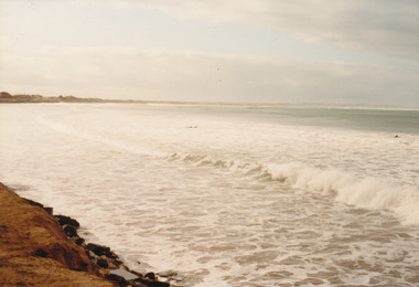 Port Fairy Historical Society Museum and Archives
Photograph
East Beach looking Northeast beach, sea, rough, ocean, dune, tide -
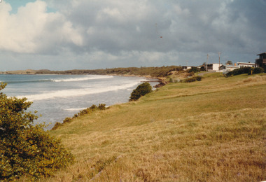 Port Fairy Historical Society Museum and Archives
Photograph
East Beach looking South June 1983east beach, groins, houses, marram grass, dune, 1983 -
 Port Fairy Historical Society Museum and Archives
Photograph
South Beach 2000south beach, 2000, rocks, ocean, sea, dune -
 Phillip Island Conservation Society Inc.
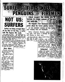
Work on paper - Photocopy of newspaper cutting, The Express, "SURFERS' FIRES KILL/ PENGUINS - FIREMEN//NOT US:/SURFERS"
Written during the 1960s when surfing was burgeoning across Australia’s coast and Phillip Island surf beaches had become extremely popular, few management strategies were in place to control interaction of the public with the delicate flora and fauna of the coastal environments. There were few good access tracks, car parks, bins, toilets etc at coastal/surfing hotspots around the Phillip Island coast. A number of management issues occurred with the influx of surfers. These included dune erosion caused by surfers climbing dunes to see the surf before going on the beach; informal parking on wildlife habitat; numerous access paths from wherever cars were parked down to the beach cutting through habitat; illegal camping on foreshores; illegal lighting of fires on beach and in dunes; surfers’ dogs let out of the car while surfers were out on the water. The dogs were uncontrolled. Certainly some surfers behaved responsibly, as is almost invariably the case these days. However, in that era of this article few people understood the delicate nature of the coastal environment and that it need to be protected through public education, infrastructure and enforcement of regulations. As now, most rural Fire services were run by dedicated volunteers who faced many challenges in their roles as Country Fire Authority firefighters. However, it was not uncommon for visitors and locals to also assist with fire-fighting efforts.The article is significant in containing quotes from both sides of the discussion who were directly involved in coastal fire incidents on Phillip Island in the 1960s. It also indicates the large number of surfers visiting Phillip Island beaches, the volunteer nature of the firefighting service and the extra challenges they faced on Phillip Island as a visitor destination. The anonymous university student surfer who is quoted, also describes possible causes of the fires, methods he and his fellow surfers used to extinguish the fires and raise the alarm, and the way they assisted the volunteer firefighters . The reference to him breaking into one of the Summerland housing estate holiday houses is also significant because that housing estate was purchased over 2 decades by successive Victorian governments to remove management issues caused to the wildlife habitat on Summerland Peninsula.Photocopy of newspaper cuttings including 2 related articles. Five columns of black text on white paper with one poorly reproduced photo bottom rightphillip island, cat bay, country fire authority, artie murdoch, alf towns, frank dixon, barry thompson, newhaven-san remo rural fire brigade, penguin parade, cowrie beach, surfers, coastal fires -
4th/19th Prince of Wales's Light Horse Regiment Unit History Room
Field Sketch, From General Chaytor's HQ After the battle of Bir El Abd, c 1917
A field sketch by Sgt Otho Hewett looking North toward Bir El Abd (a well near Arish). The country depicted is a vast area of sand dunes, with the only named features being the Canterbury MR Graves, Bir El Abd (a well), graves, Hod el Zawara and Old Turk telegraph line.field sketch, bir el abd -
 Port Fairy Historical Society Museum and Archives
Photograph
East beach near Battery HillColoured photograph of Empty beach with scrub and picket fence in foregroundeast beach, battery hill, ocean, sea, dune, tea tree, tree -
 Federation University Historical Collection
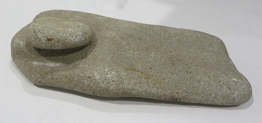
Ethnographic Material, Stone grinding/sharpening tool
Stone grinding/sharpening tool with 'bump' which could be used as a handle. Evidence of wear due to sharpening on both sides of the stone. The rock is calcite cemented quartz sandstone; it is sedimentary quartzite with a granular appearance. It has a soft matrix, and is pale, indicating its calcite nature, as well as dissolved pits. Its origin is from dry land soils and dunes. aboriginal, stone, tool, archaeology, stone tools, sandstone, quartzite, calcite -
 Glenelg Shire Council Cultural Collection
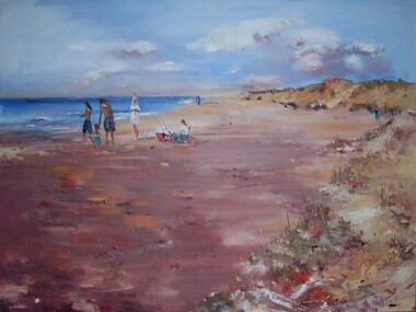
Painting, Julie Kent, Beach Scene, n.d
Hung in CEO's Office 5/9/2003Scene depicting a beach. On the right are sand dunes with grass covering them. On the left is the ocean. The beach runs from foreground left to the upper centre of image, diminishing in size. In centre left of image three standing adult figures and one child stand to the left of a seated figure wearing a red hat. A fishing pole is braced in the sand beside the figure's chair.Front: J Kent (blue paint, lower right) Back: (unknown) -
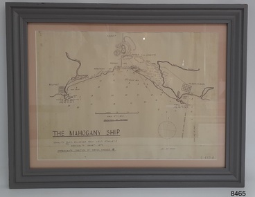 Flagstaff Hill Maritime Museum and Village
Document - Location Chart, The Mahogany Ship, 2007
This chart shows a possible site for the fabled wreck called the 'Mahogany Ship'. Flagstaff Hill’s collection includes other objects that some say could be relics from this Ancient Wreck, (also called the Gold Ship, or the Ancient Vessel). The chart shows the coordinates for the Summits of Griffith Island and of Middle Island. It also has the depths of the sea at various intervals and shows the shore and sand dunes, lighthouses and other reference points. The mystery of the Mahogany Ship began in 1836 when two shipwrecked sealers discovered the remains of an “ancient vessel” in the sand dunes about four miles west of Warrnambool. Since the last recorded sightings in the 1880’s the true origin of the Mahogany Ship has remained one of Australia’s most famous historical mysteries or fables. One of the more recent theories is that the vessel was one of the Portuguese ships exploring the Australian coast in 1522. For over one hundred years searchers have attempted to locate and identify the wreck. The search continues for the tangible evidence which will once and for all establish the Mahogany Ship’s place in Australia’s History.The chart represents the worldwide interest in locating the wreck of the Mahogany Ship. Locating the actual wreck or proving the existence of a Portuguese ship's wreck could change the history of the discovery of Australia. A Mahogany Ship committee was formed to gather and research information about the discovery of the wrecked ship. A large amount of money was offered as a prize for finding the wreck or parts of it. People have written books, painted images, made videos and told tales of the ship but it continues to remain a mystery or even a fable. The chart is significant for its possible link to one of Victoria’s and Australia’s maritime mysteries, the Mahogany Ship (also known as the Ancient Wreck). It is one of very few known relics that could give evidence of the existence and history of the vessel. It is listed on the Victorian Heritage Register S438 as it is one of Victoria’s oldest recorded shipwrecks. The identity of the vessel has the potential to change Australia’s history.A chart in a wooden frame, behind glass. The chart shows the approximate position of the mystery Ancient Wreck, later called the "Mahogany Ship". The chart is a copy and is based on the Admiralty Chart by Lieut. Stanley, dated 1872. Lower left: "THE MAHOGANY SHIP" "LOCALITY PLAN, ENLARGED FROM LIEUT. STANLEY'S ADMIRALTY CHART 1872" "APPROXIMATE POSITION OF WRECK MARKED [symbol of a Portuguese cross]" Other labels on chart: "BELFAST" "PORT FIARY" "GRIFFITHS I" "RIVER MOYNE" "RIVER MERRI" "ARMSTRONG BAY" " GORMANS LANE" "TOWER HILL" "KOROIT" "HELEN ROCK" "WARRNAMBOOL" "LADY BAY" "MIDDLE I" "LIGHT HO." Lower right: "G 410 B" Label on the back; "This chart presented to the Mahogany Ship Committee and Flagstaff Hill by Avis Quarrell, April 2007"warrnambool, shipwrecked coast, flagstaff hill maritime museum, shipwreck coast, mahogany ship, ancient vessel, ancient wreck, portuguese ship, coastal reserve, fabled wreck, gold ship, griffiths island, belfast (now port fairy), koroit, location plan, leuit. stanley, admiralty chart 1872, tower hill, merri river, moyne river, middle island, helen rock, armstrong bay, griffiths land -
 Port Fairy Historical Society Museum and Archives
Photograph
East Beach looking Southeast beach, dune, sea, ocean, life saving, equipment, rubber boat, path