Showing 99 items matching dune
-
 Phillip Island Conservation Society Inc.
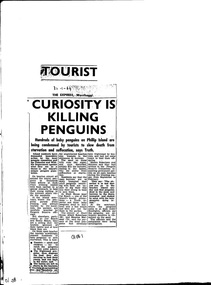
Work on paper - Newspaper cutting, Unknown journalist, the Express newspaper, Wonthaggi, "Tourist Curiosity is killing penguins", 30.01.1964
Due to increased numbers of tourists in the post-World War Two era, and the increased popularity of the Penguin Parade, without sufficient public education or protection of the penguin habitat, many Little Penguins perished during the 1960s. Trampling, unsupervised interference with the birds, unrestricted access to their dune habitat, plus predation by foxes, cats and dogs, led to most of the rookeries outside of the Summerland patrolled areas - such as on the west and north Phillip Island coasts, and parts of the south coast - being obliterated by the mid 1970s.this article is highly significant as it was published shortly before the establishment of the Phillip Island Conservation Society Inc in 1968, which commenced agitation to make management of Crown Land by Phillip Island Shire Council and government bodies accountable for protection of wildlife habitat on Phillip Island.photocopy of newspaper cutting. Black print on white paper. 3--1-64phillip island, penguin parade, little penguin, habitat destruction, penguin parade committee, shell house, -
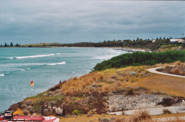
 Ballarat Heritage Services
Photograph, Clare Gervasoni, Apollo Bay, Victoria, 24/01/2022
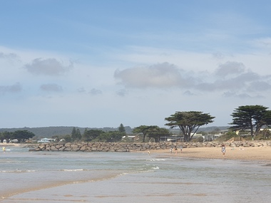
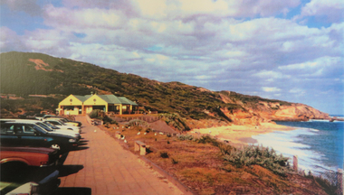
In 2021, the Department of Environment, Land, Water and Planning (DELWP) constructed two new groynes and a section of rock seawall at Apollo Bay to help manage the impacts of coastal erosion. The new 70-meter-long rock groynes run perpendicular to the shoreline and be located just south of the Milford St revetment and to the south of Milford Creek. Sections of rock seawall will be constructed between the two Groynes with an aim to protect the dune, walking path, cypress trees and road from erosion. Colour photograph of a coastal scene at Apollo Bay, featuring new rock groynes to protect the Great Ocean Road from erosion. apollo bay, beach, coast, groyne, rockwall -
 Ballarat Heritage Services
Photograph, Clare Gervasoni, Apollo Bay, Victoria, 24/01/2022
In 2021, the Department of Environment, Land, Water and Planning (DELWP) constructed two new groynes and a section of rock seawall at Apollo Bay to help manage the impacts of coastal erosion. The new 70-meter-long rock groynes run perpendicular to the shoreline and be located just south of the Milford St revetment and to the south of Milford Creek. Sections of rock seawall will be constructed between the two Groynes with an aim to protect the dune, walking path, cypress trees and road from erosion. Colour photograph of a coastal scene at Apollo Bay, featuring new rock wall and groynes to protect the Great Ocean Road from erosion. apollo bay, beach, coast, groyne, rockwall -
 Ballarat Heritage Services
Photograph, Clare Gervasoni, Sea Wall at Apollo Bay, Victoria, 24/01/2022
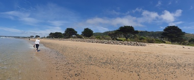
In 2021, the Department of Environment, Land, Water and Planning (DELWP) constructed two new groynes and a section of rock seawall at Apollo Bay to help manage the impacts of coastal erosion. The new 70-meter-long rock groynes run perpendicular to the shoreline and be located just south of the Milford St revetment and to the south of Milford Creek. Sections of rock seawall will be constructed between the two Groynes with an aim to protect the dune, walking path, cypress trees and road from erosion. Colour photograph of a coastal scene at Apollo Bay, featuring new rock wall and groynes to protect the Great Ocean Road from erosion. apollo bay, beach, coast, groyne, rockwall, sea wall -
 Ballarat Heritage Services
Photograph, Clare Gervasoni, Sea Wall at Apollo Bay, Victoria, 24/01/2022
In 2021, the Department of Environment, Land, Water and Planning (DELWP) constructed two new groynes and a section of rock seawall at Apollo Bay to help manage the impacts of coastal erosion. The new 70-meter-long rock groynes run perpendicular to the shoreline and be located just south of the Milford St revetment and to the south of Milford Creek. Sections of rock seawall will be constructed between the two Groynes with an aim to protect the dune, walking path, cypress trees and road from erosion. Colour photograph of a coastal scene at Apollo Bay, featuring new rock wall and groynes to protect the Great Ocean Road from erosion. apollo bay, beach, coast, groyne, rockwall, sea wall -
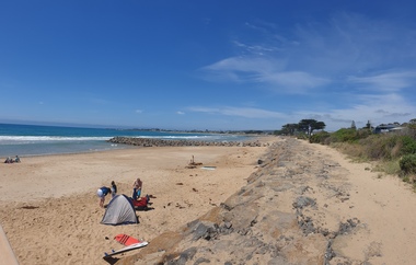
 Port Fairy Historical Society Museum and Archives
Photograph
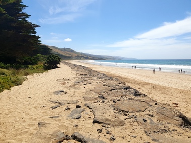
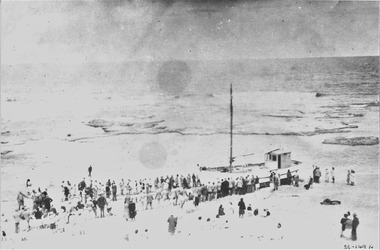
East Beach looking Southeast beach, dune, sea, ocean, life saving, equipment, rubber boat, path -
 City of Kingston
Photograph - Colour, 6 March 1993
Edithvale is a suburb in the City of Kingston. It is located between Aspendale and Chelsea on the Port Phillip Bay and built within remnant areas of the Carrum Carrum swamp. The foreshore precinct comprises a wide sandy beach, with low sand dunes and numerous historic boat sheds. The suburb consists of older style dwellings and former holiday houses, combined with mid-century housing and newer homes. The large blocks are increasingly subdivided and the existing dwellings demolished to accommodate units and townhouses, thus changing the landscape of the area and reducing the tree canopy.The beachside suburb of Edithvale was previously part of the extensive Carrum Carrum Swamp. The area was once a source of fish and eels for the Mayone-Bulluk clan of the Bunurong people. Over time the area was drained and predominantly devoted to dairy farming and holiday houses. The farms were gradually sold and subdivided with a large number of homes built after World War II and in the 1960s. Edithvale is mainly residential with a shopping strip along Nepean Highway but little significant industry was ever established in the area apart from a plaster works and confectionary factory, both now closed.Laminated aerial colour photograph of Edithvale as viewed from Alexandra Avenue in the north to Ella Grove Chelsea/Edithvale in the south. regents Park Aspendale can be seen in the top left. The area is built-up with residential housing and facilities including Edithvale Primary School, numerous churches and the Edithvale Railway station. Large sections depict the remnant Carrum Carrum swamp. Edithvale Common and the former "Duck Inn" (Melbourne Water/Friends of Edithvale Seaford Wetlands) can be seen. Edithvale Recreational reserve, the valodrome and Edithvale Public Golf Course are prominent. The image shows vacant land in the area now known as Aspendale Gardens and the newer residential section of Chelsea Heights is not developed. A bike path has been established to cover the secondary drain. The Golf Links Court residential development located off Hughes Avenue is a large vacant block.Black type on white adhesive label: 6-3-93 Black type on white adhesive label: 25/9211, 6/3/93, 11.20 am Black type on white adhesive label: 9211 Yellow circular adhesive sticker Black pencil: 9211 6-3-93 arrow pointing Nedthvale, carrum carrum swamp, aspendale, chelsea -
City of Kingston
Photograph - Colour, Circa 1993
Edithvale is a suburb in the City of Kingston. It is located between Aspendale and Chelsea on the Port Phillip Bay and built within remnant areas of the Carrum Carrum swamp. The foreshore precinct comprises a wide sandy beach, with low sand dunes and numerous historic boat sheds. The suburb consists of older style dwellings and former holiday houses, combined with mid-century housing and newer homes. The large blocks are increasingly subdivided and the existing dwellings demolished to accommodate units and townhouses, thus changing the landscape of the area and reducing the tree canopy.The beachside suburb of Edithvale was previously part of the extensive Carrum Carrum Swamp. The area was once a source of fish and eels for the Mayone-Bulluk clan of the Bunurong people. Over time the area was drained and predominantly devoted to dairy farming and holiday houses. The farms were gradually sold and subdivided with a large number of homes built after World War II and in the 1960s. Edithvale is mainly residential with a shopping strip along Nepean Highway but little significant industry was ever established in the area apart from a plaster works and confectionary factory, both now closed.Aerial colour photograph of Edithvale as viewed from Alexandra Avenue in the north to Ella Grove Chelsea/Edithvale in the south. The area is built-up with residential housing and facilities including Edithvale Primary School, numerous churches and the Edithvale Railway station. Large sections depict the remnant Carrum Carrum swamp. Edithvale Common and the former "Duck Inn" (Melbourne Water/Friends of Edithvale Seaford Wetlands) can be seen. Edithvale Recreational reserve, the valodrome and Edithvale Public Golf Course are prominent. The image shows vacant land in the area now known as Aspendale Gardens and the newer residential section of Chelsea Heights is not developed. A bike path has been established to cover the secondary drain. The Golf Links Court residential development located off Hughes Avenue is a large vacant block.Yellow circular adhesive sticker on plastic Black ink (marker): * (asterisk) Black type on white adhesive sticker: P000108edithvale, aspendale, chelsea, carrum carrum swamp -
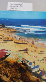 Peterborough History Group
Photograph - Surf Carnival, Newfield Bay, Jocelyn Burt
Unusual choice of location by Port Campbell Surf club due to Port Campbell beach being too small. The Surf Carnival was held at Newfield Bay (possibly for two years running). Eyewitness accounts advise that one year the surf was so rough that the event was abandoned. This photograph appears to show calmer sea. In order to get the surf boats onto the beach a track was bulldozed over the sand dunes. Spectators cars were parked in the area which is now the airstrip, on the corner of the Port Campbell Peterborough Road and the Timboon Peterborough road.Town eventOriginal photograph of the surf carnival, taken from the west looking towards the east, with the Crown of thorns visible in the background. Surf boats are on the beach and umbrellas are visible. Occurred in the early 1970's.Written on the back is Jocelyn Burt, who is a photographer.newfield bay, surf lifesaving carnival, peterborough, jocelyn burt, crown of thorns rock formation -
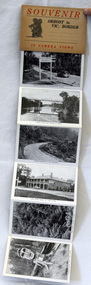 Orbost & District Historical Society
post cards, ca. 1945
This is a souvenir of Orbost from 1945.A set of 13 black and white postcards in a fold-out format. Pictures are of : Nicholson Street, Snowy Rriver flats from Grand View, avenue leading to Obost. Snowy River bridge at Orbost, Snowy River at Orbost, Marlo from the sand dunes, Prince's Highway at Victorian-NSW. border, Genoa River and bridge at Genoa, Prince's Highway at Mt. Drummer, Cann River hotel, fern scene, Euchre Valley, ponsasinorum near Cann River. SOUVENIR Orbost to Vic Border 13 camera viewspostcard souvenir photographs orbost cann-river -
 Queenscliffe Maritime Museum
Photograph - JAMES WILLIAM stranded Pt Lonsdale, JAMES WILLIAM beached at Point Lonsdale, 1953
JAMES WILLIAM fishing boat beachedstranded JAMES WILLIAMBlack & white photo of the fishing boat JAMES WILLIAM stranded & beached at Point Lonsdale Reverse - " The JAMES WILLIAM stranded approx 1/2 mile west of the Pt Lonsdale lighthouse / owner James 'Dugga' Warren, crewman C Zanoni / For date - see L Ferrier / salvaged by jacking up, putting cradle under, 300-400 people pulled her up under dunes, on planking tracks and rollers / 3 weeks later used the same procedure to launch her into sea. "historical references, fishing boat, stranded & beached, james william -
Warrnambool and District Historical Society Inc.
Document - Warrnambool Playground of the South Tourist Guide, Collett & Bain, 1959
A 1959 tourist guide showcasing Warrnambool attractions.This guide gives an insight into tourist attractions and facilities in Warrnambool in the late 1950'sThis 24page paper booklet contains colour and black and white photographs and text showcasing Warrnambool as a tourist destination. The front cover has an illustration of a young man on the sand dunes, a small map of Victoria locating Warrnambool in the bottom left hand corner and stylised tourist activities in the top right hand quadrant. The rear cover has a photograph of a woman in a swimsuit holding a green surf board surrounded by stylised tourist activities printed in red ink. There is a blue banner across the bottom of the rear cover.Front cover: Warrnambool Playground of the South Rear cover: A Warrnambool Holiday for Everyonewarrnambool, warrnambool tourist guide -
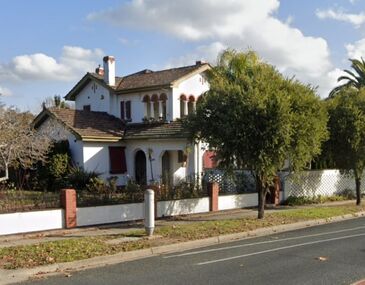 Wodonga & District Historical Society Inc
Photograph - McHarg Home, Wodonga
John Clarence (McKenzie) McHarg was born in Corryong, Victoria on 12 August 1905 to Hugh Patrick McKenzie-McHarg and Laura Mary Dune. After attending school at Christian Brothers’ College in Albury, he also attended St Patrick’s College at Ballarat. Mr McHarg then studied at Melbourne University, graduating with a Bachelor of Law. After graduating he completed his studies with Messrs. Mahoney and O’Brien of Melbourne with whom he entered a partnership. In 1931 John McHarg appears on the electoral roll for Wodonga listed as a barrister. The following year he opened his legal practice in Sydney Road, Wodonga. Jack (John) McKenzie McHarg married Eva Whyte in 1934 and the house called “Baelon” was built around this time. THe builder was Rob McCulloch. McHarg is first listed as paying rates on the house in Beechworth Road in 1934-35. He died on 12 January 1996 in Wodonga after many years of service to the Wodonga and district community. The house is still in the hands of the McKenzie-McHarg family. This building is one of the oldest remaining homes in Wodonga and was owned by a prominent community member.A series of photos depicting the home of the McHarg family in Wodonga. One is from a Rose Series postcard c1940, the second is of the house shrouded in snow in 1967. The final image shows the house in 2023.mcharg house, wodonga buildings, mcharg solicitor, mckenzie-mcharg -
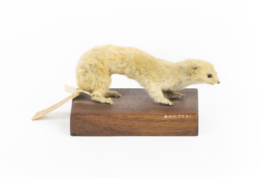 The Beechworth Burke Museum
Animal specimen - Weasel, Trustees of the Australian Museum, 1860-1880
The Weasel is the smallest carnivorous mammal in the world. They commonly reside in central and western Europe and in the Mediterranean region. They can also be found in North Africa, Asia and North America. This species was also later introduced to New Zealand. The Weasel prefers to live in locations which include grasslands, sand dunes, lowland forests, upland moors and towns which have a suitable food source. Collective nouns for a group of Weasels include a "sneak", a "boogie", a "gang" or a "confusion". This specimen is part of a collection of almost 200 animal specimens that were originally acquired as skins from various institutions across Australia, including the Australian Museum and the National Museum of Victoria, as well as individuals such amateur anthropologist Reynell Eveleigh Johns between 1860-1880. These skins were then mounted by members of the Burke Museum Committee and put-on display in the formal space of the Museum’s original exhibition hall where they continue to be on display. This display of taxidermy mounts initially served to instruct visitors to the Burke Museum of the natural world around them, today it serves as an insight into the collecting habits of the 19th century.This specimen is part of a significant and rare taxidermy mount collection in the Burke Museum. This collection is scientifically and culturally important for reminding us of how science continues to shape our understanding of the modern world. They demonstrate a capacity to hold evidence of how Australia’s fauna history existed in the past and are potentially important for future environmental research. This collection continues to be on display in the Museum and has become a key part to interpreting the collecting habits of the 19th century.A light coloured weasel standing on a wooden platform. Two identification tags are tied to one of the specimen's back legs. The animal has a long and slim body with a small and triangular shaped head. The teeth are visible from close-up and the eyes have been replaced by dark coloured glass. The snout is pointed and the weasel has long whiskers. The ears are small and rounded.A.4491 ?. Weasel sp. / Catalogue, page, 48 /taxidermy mount, taxidermy, animalia, burke museum, beechworth, australian museum, skin, reynell eveleigh johns, squirrel -
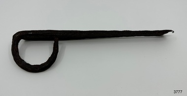 Flagstaff Hill Maritime Museum and Village
Functional object - Latch, before 1890
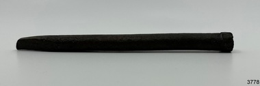
In Flagstaff Hill’s collection are items associated with the Ancient Wreck, (also called the Gold Ship, Mahogany Ship or Ancient Vessel). Three relics were located in 1890, due to the ‘interest of a public works inspector, James Gilroy, who dug in the ship’s remains’. One of the relics was a heavily oxidated ‘quantity of ironwork’. The other two, now part of Flagstaff Hill’s collection, are - an iron latch probably from a galley oven door or fireplace - a bronze bolt (spike or pin) Both of these relics are listed on the same page in the records of the Old Warrnambool Museum, found by K.A.G. (or H.A.G.) on the site of the Ancient wreck in 1890. Interestingly, another item in these records is ‘Notes on Ancient wreck, near Gorman’s Lane’. Gorman’s Lane is just inland from the sand dunes of the Coastal Reserve at Tower Hill. The current location of these Notes is unknown. Another item thought to be a relic from the Mahogany Ship was the amphora or jug, also in Flagstaff Hill's collection. It was found in 1934 on a local property and donated in 1985. The Museum opened in 1886 and continued until 1963, when it was closed by the Warrnambool City Council and the whole collection was put into storage. The council then transferred items to various places including Flagstaff Hill and the current Warrnambool Art Gallery. Flagstaff Hill’s early Accession Records book lists the items as being received from the Old Warrnambool Museum collection; the Latch is record 152 and the Pin is record 153. An article, ‘Birthplace of our History’ by Don Dean, is on file in the Warrnambool and District Historical Society. It was published in the Australian POST, on March 17, 1955. This article describes the finding of the items going back to 1890, along with other information about sightings of what has come to be known as the Mahogany Ship. The mystery of the Mahogany Ship began in 1836 when two shipwrecked sealers discovered the remains of an “ancient vessel” in the sand dunes about four miles west of Warrnambool. Since the last recorded sightings in the 1880’s the true origin of the Mahogany Ship has remained one of Australia’s most famous historical mysteries. One of the more recent theories is that the vessel was one of the Portuguese ships exploring the Australian coast in 1522. For over one hundred years searchers have attempted to locate and identify the wreck. The search continues for the tangible evidence which will once and for all establish the Mahogany Ship’s place in Australia’s History. The latch has local historic significance as it was found in the sand dunes of Warrnambool in 1890. The latch is also significant for being part of the original 1886 Warrnambool Museum's collection. The latch is significant for its possible link to one of Victoria’s and Australia’s maritime mysteries, the Mahogany Ship (also known as the Ancient Wreck). It is one of very few known relics that could give evidence of the existence and history of the vessel. It is listed on the Victorian Heritage Register S438 as it is one of Victoria’s oldest recorded shipwrecks. The identity of the vessel has the potential to change Australia’s history.Latch, iron. Flat iron latch tapers inward from loop handle to narrow end with prongs. Handmade. warrnambool, shipwrecked coast, flagstaff hill maritime museum, shipwreck coast, mahogany ship, latch, relic, old warrnambool museum, ancient vessel, ancient wreck, oven latch, fireplace latch, galley oven, gold ship, gorman's lane, coastal reserve, tower hill -
 Flagstaff Hill Maritime Museum and Village
Functional object - Bolt, before 1890
Flagstaff Hill’s collection has items that are thought to be relics from the Ancient Wreck, (also called the Gold Ship, Mahogany Ship or Ancient Vessel). Three relics were located in 1890, due to the ‘interest of a public works inspector, James Gilroy, who dug in the ship’s remains’. One of the relics was a heavily oxidated ‘quantity of ironwork’. The other two, now part of Flagstaff Hill’s collection, are - an iron latch probably from a galley oven door or fireplace - a bronze bolt (spike or pin) Both of these relics are listed on the same page in the records of the Old Warrnambool Museum, found by K.A.G. (or H.A.G.) on the site of the Ancient wreck 1890. Interestingly, another item in these records is ‘Notes on Ancient wreck, near Gorman’s Lane’. Gorman’s Lane is just inland from the sand dunes of the Coastal Reserve at Tower Hill. The current location of these Notes is unknown. Another relic is thought to be the amphora, discovered in 1934 on a local property. The Museum opened in 1886 and continued until 1963, when it was closed by the Warrnambool City Council and the whole collection was put into storage. The council then transferred items to various places including Flagstaff Hill and the current Warrnambool Art Gallery. Flagstaff Hill’s early Accession Records book lists the items as being received from the Old Warrnambool Museum collection; the Latch is record 152 and the Pin is record 153. An article, ‘Birthplace of our History’ by Don Dean, is on file in the Warrnambool and District Historical Society. It was published in the Australian POST, March 17, 1955. This article describes the finding of the items going back to 1890, along with other information about sightings of what has come to be known as the Mahogany Ship. The mystery of the Mahogany Ship began in 1836 when two shipwrecked sealers discovered the remains of an “ancient vessel” in the sand dunes about four miles west of Warrnambool. Since the last recorded sightings in the 1880’s the true origin of the Mahogany Ship has remained one of Australia’s most famous historical mysteries. One of the more recent theories is that the vessel was one of the Portuguese ships exploring the Australian coast in 1522. For over one hundred years searchers have attempted to locate and identify the wreck. The search continues for the tangible evidence which will once and for all establish the Mahogany Ship’s place in Australia’s History. The bolt has local historic significance as it was found in the sand dunes of Warrnambool in 1890. The bolt is also significant for being part of the original 1886 Warrnambool Museum's collection. The bolt is significant for its possible link to one of Victoria’s and Australia’s maritime mysteries, the Mahogany Ship (also known as the Ancient Wreck). It is one of very few known relics that could give evidence of the existence and history of the vessel. It is listed on the Victorian Heritage Register S438 as it is one of Victoria’s oldest recorded shipwrecks. The identity of the vessel has the potential to change Australia’s history.Bolt, also referred to as spike or pin. Bronze bolt, round body with head on one end that has straight sides, tapers to a point at the other end.warrnambool, shipwrecked coast, flagstaff hill maritime museum, shipwreck coast, mahogany ship, relic, pin, spike, old warrnambool museum, nail, ancient vessel, ancient wreck, portuguese ship, gold ship, gorman’s lane, coastal reserve, tower hill -
 Flagstaff Hill Maritime Museum and Village
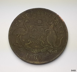
Currency - Coin, Robert Hyde & Co. Shipping Merchants, 1861
The donor (a local resident.) of this coin found this penny token coin in the sand dunes of Lady Bay, Warrnambool, in 2023. The coin could have come from a local shipwreck, passengers, or members of the community. Trade was carried out along the southwest coast of Victoria between Melbourne and Portland, with the Port of Warrnambool receiving passengers and goods by coastal traders, the steamboat that set off from ports every few days. One such vessel was the steamship SS Edina that made her first voyage from Melbourne to Portland in 1863. For around a decade or so in the Gold Rush period in Australia there was a shortage of official government currency. It was acceptable during this time to use token coins minted by local businesses to be used within their store, much like the loyalty and rewards cards that businesses give their customers in modern times. The tokens were also a good way to advertise their wares and details. The first token was introduced in Melbourne in 1848 and were used until 1868, when they became illegal in New South Wales. They were minted in Australia and overseas. The token was issued by Robert Hyde & Co. who traded in second-hand goods such as old clothes, sheets, metal items and glass, which they resold to be re-manufactured, or "recycled".A token such as this one identifies businesses existing in the post-Gold Rush period in Australia. Round copper coin. Penny token coin bearing the Australian Coat of Arms and motto. The coin also has the company's name, location, nature of business and motto. The coin has grooves around the edge. It was made in 1861.OBVERSE: Logo: (Australian Coat of Arms), Motto: "PEACE & PLENTY", Date: 1861 REVERSE: "ROBERT HYDE & CO MELBOURNE", "GENERAL MARINE STORE, SHIPPERS OF RAGS GLASS METALS &.C"flagstaff hill maritime museum and village, warrnambool, great ocean road, shipwreck coast, merchant token, melbourne, token, australian token, trade token, coins, merchants, medal, colonisation, gold rush, robert hyde & co., general marine store, shippers of rags glass metals etc., numismatics, second-hand scrap, scrap goods -
 Flagstaff Hill Maritime Museum and Village
Ceramic - Amphora, mid-to-late 1800s
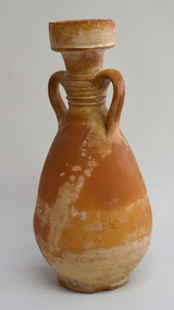
This amphora or jug, with a silhouette shaped like a woman with hands on hips wearing a long flared-out skirt. The design was used in ancient Greece for pottery storage jars, the neck being narrower than the body. The amphora was discovered by Joe O'Keeffe in 1934 in a sand blowout west of Levy's Point west of Warrnambool while he was planting marram grass for Mr Duncan. An article in the Warrnambool Standard newspaper of December 21, 1985, states that the amphora may be linked to the wooden sailing ship called the Mahogany Ship (also called the Ancient Wreck). Thermoluminescence testing indicates the relic was made in the mid-to-late 1800s and experts suggest it was of North African origin. The presence of the amphora in the sand dunes, and the amphora itself, are still a mystery. The amphora was donated to Flagstaff Hill on a long-term loan by the Duncan family and displayed to the public for the first time on December 21, 1985, until February 2023 when the display was returned to storage to rest with the redevelopment of the Assistant Lighthouse Keepers Cottage (Shipwreck Museum). An extensive search for members of the Duncan Family has been undertaken by Flagstaff Hill and stakeholders to resolve the loan term loan, but the family is not known. As such to properly care for the amphora, it has been registered until ownership can be determined.The object is significant for its possible link to one of Victoria’s and Australia’s maritime mysteries, the Mahogany Ship (also known as the Ancient Wreck). It is one of very few known relics that could give evidence of the existence and history of the vessel. It is listed on the Victorian Heritage Register S438 as it is one of Victoria’s oldest recorded shipwrecks. The identity of the vessel has the potential to change Australia’s history.Amphora or jug; earthenware, orange clay with areas of cream. The vessel has a wide mouth, a deep lip, two opposing handles between the neck and shoulder, and a bulbous body. The curved handles have a design of six bands between them. There are three rings of small dots encircling the body. The underside has concentric circles in the clay, uneven edge and pinhole markings. Pinhole patterns: [3 holes above 3 holes] opposite [3 holes above 3 holes], 1 hole] [ 1 hole above 2 holes]flagstaff hill maritime museum and village, warrnambool, great ocean road, shipwreck coast, amphora, jug, mahogany ship, ancient wreck, joe o'keefe, duncan, thermoluminescence, north africa, levy point, pottery, storage jar -
 Phillip Island and District Historical Society Inc.
Photograph - Photographs of Phillip Island, 1920s and 1940s
Photographs associated with Public Schools camp, that started in the 1930s. Some boys worked on chicory at McFee's farm. 314-05 was possibly located at Trenavin Farm, Ventnor. (Source Jan Andrews ) Photo of people on cart with tank stand was off to a 7 picnic at the Nobbies 1917. [See 1124-01] Keeston Sambell driving, behind him is Betty Parker. on side from left is May Lambert, Jim Patterson, Jim Blake, Carmen Sambell and Bill Sambell.[ Source Jim Blake] Eight black & white photographs. 314-01. Photograph of horse and cart with 2 women, 2 girls and 5 boys. 314-02. Photograph of a mixed group of 7 people on a horse and drag. 314-03. Photograph of 3 young adult males and a dog standing in front of a wooden building. 1926 “Campers Rest” Labelled The Immortal camp at Ventnor. Poss. Trenavin Park 314-04. Photograph of 5 boys and 1 woman swimming in rock pool. 1 boy watching. 314-05. Photograph of old wooden hut with tank and chimney. Appears to have been used by boys when camping. 314-06. Photograph of 4 boys - 2 in swimming costumes - on the beach. 314-07. Photograph of 3 women and 1 girl sitting on sand dunes. 314-08. Photograph of 3 boys in uniform and 1 man sitting on bench - maybe watching sporting event?scotch college camp phillip island, scotch college boys, s j mcfee, c.k. newman, f. r. newman, trenavin park phillip island, sambell family, jim blake, betty parker -
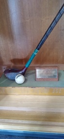 Peterborough History Group
Souvenir - Bay of Islands Championshiop trophy
Informal 12 hole golf event, played on Grand Final weekend. This event was started by a group of friends when there were few official golf tournaments played at Peterborough. The event was a stroke event with "mystery handicaps" ie you didn't know your handicap until you finished playing. The event was played on the Sunday of Grand Final weekend (except initially); Friday night traditionally was tea at Boggy Creek Pub and a Fishing Comp on Saturday. The name came about because three of the regular players, Ivan Voss, Bob Loader and R. McKendrick had a hut at the top of the dunes near Crofts Bay. They had a clinker boat on the beach as well. They subsequently built a house in Childers St. It ceased when the original participants were no longer able to play. The date of the first winner is 1980, last recorded winner is 1995. No longer played. further information required. Winners: 2nd August 1980 F. Virgona, 8th March 1981, R Case 25th September 1982, E Brierly 24th September 1983, R Mckendrick, 28th September 1984 D Stead, 28th September 1985 I Turnbull, 27th September 1986 J Charles, 26th September 1987 I Voss, 1988 no winner, 1989 F Carlin, 1990 B Turner, 1991 R Pollock, 1992 S McGuire 25th September 1993 B haskett 1st of october 1994 R pollock 30th of september 1995.Shortened golf driver and cracked ball mounted upon a wooden base with names engraved on metal surround.Engraved names, listed below, on metal plate affixed to the base.golf, peterborough golf club, golf tournment -
 The Beechworth Burke Museum
Geological specimen - Coorongite
Coorongite is a dark, rubber-like, highly resilient structureless algal deposit. In the Coorong district of South Australia it occurs in moderate quantities associated with the coastal swamps and sand dunes which extend for a considerable distance east of the mouth of the Murray. This particular specimen was recovered from the south of the Coorong River, South Australia. A type of sediment rich in organic matter, Coorongite is the unlithified end-member of the sapropelic coal series. The members of the sapropelic coal series can be ranked in order as sapropel (the unlithified form), sapropelic-lignite, and sapropelic-coal (the lithified forms) based on increasing carbon content and decreasing volatile content. Sapropel (Coorongite) is an unlithified dark, pulpy, fine organic mud containing concentrations of algae and miospores that are more or less identifiable. Coorongite is typically found as an algae like substance, that can be found in irregular size pieces. Coorongite was believed to be dried up oil due to its rubber-like texture. The Coorongite is also soft to the point where it can be cut into with a knife or it can be broken and torn by hand. Otherwise known as 'Kurangk', the Coorong River is home to the Ngarrindjeri people, which acts as both a place for gathering food and a spiritual place. In 1852 the first sight of Coorongite was found along the Coorong River. The finders mistook the Coorongite for dried up oil, which lead to the belief that there were oil reserves under the Coorong River. Between the 1860s and the 1930s the Coorong River became a place where mining oil and Coorongite became precedent. Nowadays, the local council and the South Australian Government are working together with the Ngarrindjeri people to sustain and preserve the Coorong River and the culture that is with it. Soon after gold was discovered in 1851, Victoria’s Governor La Trobe wrote to the Colonial Office in London, urging ‘the propriety of selecting and appointing as Mineral Surveyor for this Colony a gentleman possessed of the requisite qualifications and acquaintance with geological science and phenomena’. Alfred Selwyn was appointed geological surveyor in Australia in 1852 which began the Geological Survey of Victoria. Selwyn went on to collect geological samples and catalogue thousands of specimens around Australia. In 1853-69 the Geological Survey issued under Selwyn's direction sixty-one geological maps and numerous reports; they were of such high standard that a writer in the Quarterly Journal of the Geological Society of London bracketed the survey with that of the United States of America as the best in the world. During his years spent in Australia, Selwyn collected numerous significant geological specimens, examples of which are held in collections such as the Burke Museum.Coorongite is considered to be a mineral with a unique texture, where it can be both hard and soft. Coorongite can also be considered to be a rare mineral, as it is only located along the Coorong River and due to the mining of it, has left very few sources. It was believed at one point that Coorongite could be used to replace oil. This specimen is part of a larger collection of geological and mineral specimens collected from around Australia (and some parts of the world) and donated to the Burke Museum between 1868-1880. A large percentage of these specimens were collected in Victoria as part of the Geological Survey of Victoria that begun in 1852 (in response to the Gold Rush) to study and map the geology of Victoria. Collecting geological specimens was an important part of mapping and understanding the scientific makeup of the earth. Many of these specimens were sent to research and collecting organisations across Australia, including the Burke Museum, to educate and encourage further study.Three solid varyingly hand-sized pieces of wooden appearing organic matter derived from the river in the Coorong District in South Australia. A rubber-like, highly resilient structureless algal deposit.Specimen 245 page 69 / in Descriptive Register / "Elcestic Bitumen, / Coorangite" South of / Coorung River, South Australia . / C. WIllman / 15/4/21burke museum, beechwoth, indigo shire, beechworth museum, geological, geological specimen, mineraology, coorong, coorong river, kurangk, ngarrindjeri, south australia, coorongite, coorongite specimen -
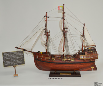 Flagstaff Hill Maritime Museum and Village
Craft - Ship Model, Portuguese Carvel, 1999
The Mahogany Ship is today regarded as a legend and refers to an ancient wreck that is purported to lie beneath the sand beside Armstrong Bay, several kilometres west of Warrnambool, Its location is currently unknown. For well over a century the mystery of this ship has fascinated Australians because the existence of such a vessel could throw a different light on the earliest phases of exploration of eastern Australia by Europeans. The story is that in January 1836 a party of whalers from Port Fairy travelled to the mouth of the Hopkins River in search of seals. Their boat overturned and one man was drowned. The three survivors were walking the 30 kilometres back to Port Fairy along the coast when, about halfway along, they discovered the wrecked ship in the dunes. It is said that Captain John Mills, who was in charge of the whaling station at Port Fairy promptly visited the wreck with several of his men, including Hugh Donnelly. Donnelly who was the originator of that version of events is now regarded as unreliable. Local history researcher Joan Fawcett believes Donnelly could not have visited the wreck in 1836 because he did not arrive in Victoria until 1841. The "mahogany" description can be traced to a letter from Port Fairy builder, architect and surveyor John Mason and published in the Melbourne Argus in 1876. He said he had seen the hull in 1846 and it "had the appearance of either cedar or mahogany." In 1884 Argus journalist `The Vagabond' wrote that the hull was built of "Spanish mahogany" and six years later Mason wrote another letter saying it might not have been mahogany but red gum or ironbark from New South Wales. He was too late with this new description as the wrecks mahogany tag was here to stay all through the hull was not visible as it had disappeared beneath the shifting sands by 1880. A more reliable account was later presented by the former editor of the Warrnambool Examiner, historian Richard Osburne, who wrote about the wreck in his book History of Warrnambool (published 1887). In it the author remembers to have noticed a wreck in the hummocks between Belfast and Warrnambool, in 1847 or 1848; he stated it was much nearer Warrnambool than Belfast, now known as Port Fairy, going on to state “in fact, it was only two or three miles from the former place, to the west of the big hummock which was supposed to fill Warrnambool Bay with drift sand washed by the Merri River before the cutting was made.” Osburne followed up with a letter to the Port Fairy Gazette on June 25, 1876, during a period of heightened interest in the wreck, although he was unsure of the provenance of the ship he went on to state in his letter. “The old wreck was, in fact, miles away from the Port Fairy beach, and only about four miles from Warrnambool. In the years 1847 and 1848. I have often seen the wreck and I regret to say I do not believe she was a foreign ship at all.”The ship model is significant for its association with the Warrnambool story of what is now referred to as the Mahogany Ship, an ancient shipwreck. The model is significant as it is an interpretation of a Portuguese caravel and possibly associated with the early history and exploration of Southern Australia. The model is a fine example of a hand crafted ship made from plans, not from a kit. Some of the materials used for the model are significant to the Gembrook community in that the timber used is a portion from a 30-meter pine tree that fell onto and destroyed the 120-year-old Gembrook church building. The model is also a dedication to Edward Kermond, who grew up in Warrnambool and claimed to have seen the shipwreck in the dunes when he was a lad in the late 19th century. (See note section of this document for further information on the creator and donation of the subject item).Ship model, an interpretation of a mahogany Portuguese carvel vessel in a glass display case with wood frame and a description plaque. Model is made from dark stained wood. The three masted vessel is fully rigged, with a Portuguese-like flag on mast. Plaque is rectangular, free standing on a pedestal. The model was handmade by Joe Hilder (Senior) in 1999 from flooring obtained from the Gembrook Uniting Church in Victoria. Inscriptions, hand written, under base of case and on plaque.Under base, black felt tip pen “Ship & Case made From / Flooring from Gembrook uniting Church, Flattened in 1999 / By Large Pine Tree.” On plaque, white paint "This interpretation of the Fabled Mahogany Ship was made by Joe Hilder, Gembrook Vic. is displayed in the memory of the late Edward Kermond (Ted) 1887-1973, a Warrnambool son who claimed to have seen the original ship as a child." flagstaff hill, warrnambool, flagstaff hill maritime museum, shipwreck coast, flagstaff hill maritime village, great ocean road, ship model, mahogany ship, mahogany ship story, portuguese caravel, joe hilder, edward kermond, ted kermond, gembrook uniting church, gembrook storm 1999, port fairy whalers, belfast whalers -
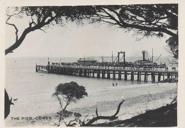 Phillip Island and District Historical Society Inc.
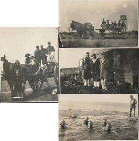
Photographs, Photo Shop Series, 1940
A collection of 18 photographs taken by Mrs Haines' sister whilst on an excursion to Phillip Island from Mt Barker High School in South Australia. 217-01 Photograph of the Cowes Pier taken from foreshore. Ferry at centre left and crowd of people on end of pier. 217-02 Photograph taken from the end of the Cowes Pier with Isle of Wight Hotel in the background. 217-03 Photograph of the Killara Ferry leaving Cowes with a crowd of people on board. 217-04 Photograph of waves surging over Bridal Veil rock platform in foreground. 217-05 Photograph of wave breaking over rock platform on the South Coast of Phillip Island. 217-06 Photograph of the Suspension Bridge from San Remo. 217-07 Photograph of a Guesthouse Dining Room. Tables covered with white cloth and fully laid, including floral arrangements. 217-08 Photograph of the War Memorial at Cowes with the pier in background. 217-09 Photograph of seals on Seal Rocks Phillip Island. 217-10 Photograph of a koala on the trunk of a Gum Tree. Handwritten on the back of the photo - "Roberta, a pet koala". 217-11 Photograph of children rolling down dune onto the beach. Children and adults standing at water's edge. 217-12 Photograph of the Killara at San Remo taken from the Suspension Bridge. 217-13 Photograph of a group of school children with teachers, young girl in the foreground, on rocks at Smith's Beach. 217-14 Photograph looking along the Suspension bridge from Newhaven end. Group of people walking toward San Remo. 217-15 Photograph of Suspension bridge from Newhaven beach. 217-16 Photograph of Mrs Melbourne and Mrs Haines sister. 217-17 Photograph of Seal Rocks taken from a boat. 217-18 Photograph of Theni Beddams - Headmistress of Shelford and Ila Tattersall (Mrs Haines) Sybil Robinson's sister together with four sailors.cowes pier phillip island, the killara ferry, ferries, wildlife - seals, wildlife - koala, suspension bridge phillip island, phillip island coastline, smith's beach, lover's walk cowes, lover's walk cowes phillip island, war memorial cowes phillip island, seals on seal rocks phillip island, seal rocks phillip island, mrs haines -
 Flagstaff Hill Maritime Museum and Village
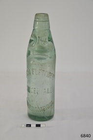
Container - Bottle, c. 1905
This bottle once contained John Fletcher’s ginger cordial. It was found in August 2014 in the sand dunes at Levy's Point, near McKinnon's quarry, Warrnambool. ABOUT JOHN FLETCHER of WARRNAMBOOL John Fletcher Cordial (or Beverage) Co . Warrnambool, supplied cordial and aerated drinks to the Western district of Victoria. John Fletcher was named as a cordial manufacturer in the Warrnambool Standard of June 13th 1895, when he attended a Publican’s Association meeting. Mr John Fletcher, aerated water and cordial manufacturer of Koroit Street Warrnambool, had a summary of his factory printed in a short article in the Advocate, Melbourne, in February 1901. The article said “one of the most complete plants outside the metropolis … spacious … well appointed …old-established business … noted for the excellence of the quality … a trial [of the beverage] is solicited.” John Fletcher and Harold Caffin, trading as J.S. Rowley & co cordial manufacturers in 1903; were prosecuted in September 1903 when the Board of Health found an analysed sample of Raspberry Vinegar to contain coal tar colouring, which could be injurious to health, particularly to the kidneys. The factory was still in operation in December 1924, when sadly, Mr S. Fletcher, who was carrying bottles of aerated water at Mr John Fletcher’s cordial factory, sustained an eye injury when one of the bottles burst. Later the eye had to be removed at the Warrnambool Base Hospital. ABOUT CODD BOTTLES During the mid-to-late 1800s there were many inventions to keep the fizz in carbonated drinks such as ginger ale, soda water and fruit drinks. Hiram Codd, an English engineer invented a successful process that he patented as “Codd’s patented globe stopper bottle” in 1872. The Codd-neck bottle (commonly called Codd or marble bottle) is manufactured in two parts. The body of the bottle is cast in two sections. At the time of joining the sections a glass marble and rubber seal are inserted into the neck section. The lip is then applied to the top of the bottle. The Codd bottle is filled upside down as the pressure of the gas from the carbonated liquid holds the marble up and out of the way. When the bottle stands upright the gas pushes the marble up against the washer, creating a firm seal to keep the fizz inside. The bottle is opened by pushing the marble down firmly to allow some of the gas to escape. The marble drops down and is caught in a depression formed in the neck. When the bottle is tilted to pour or drink the liquid the marble rests in a dimple. Some have said that the bottle as a character, the shape having a face with its mouth keeping the marble out of the drink and eyes that catch the marble so that it doesn’t roll into the mouth of the drinker. The Codd bottle was expensive to produce and children loved to destroy the marbles to play with the marbles inside. Many shops and factories added a deposit to the cost of buying the drink to encourage children to return the bottles rather than break it for the marble. Codd bottles are still being produced in India and Japan for soft drinks. A Codd bottle with the same markings as this one is valued on today’s Australian auction sites from $35 - $75 AUD. Bottle, aqua/green glass, with glass marble inside. John Fletcher's Ginger Ale, Warrnambool. Container is often called a "Codd neck bottle", “marble bottle” or “Codd’s patent bottle”. Bottle made by Dobson. Inscription on bottle and base. c. 1905Marks moulded into glass; "JOHN FLETCHER / GINGER ALE / WARRNAMBOOL" and “DOBSON” and on base “G”. flagstaff hill, warrnambool, shipwrecked coast, flagstaff hill maritime museum, maritime museum, shipwreck coast, flagstaff hill maritime village, great ocean road, codd bottle, codd neck bottle, marble bottle, ginger beer bottle, john fletcher soft drinks, warrnambool soft drinks and cordials, john fletcher cordial (or beverage) co ., codd neck bottle, glass stopper bottle, hiram codd, antique bottle, harold caffin, john fletcher -
 Mission to Seafarers Victoria
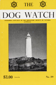
Journal (item) - Periodicals-Annual, Shiplovers' Society of Victoria, The Annual Dog Watch
This journal provides the reader with glimpses of the adventures and hardships of a seaman's life. Many of the stories are of sailing ships.Contributes to our knowledge of the importance of shipping and places on record those stories of the sea which would otherwise be lost.Contents Foreword - Commander R. S. .Veale, C.M.G. V.R.D. - 5 Editorial - - 7 Light Houses - N. S. Smith - 11 On Passing for Second Mate - R. Thiele - 18 Passenger Steamers on the Tasman Sea - I. Mackay - 22 Dune Ship - Dr. Philip Martin - 37 The Rum Runners - S. A. E. Strom - 38 To Australia Amongst Emigrants - S. Duncan - 43 The Persian Gulf or "Hells Kitchen" - K. Bull - 49 Monkey Business - Captn. James Gaby - 51 Anchor Hardy - Capt. R. G. Edwards - 52 Light Houses - C. E. Bonwick - 58 The Forlorn Hope - N. S. Smith - 59 Robert Louis Stevenson in The South Seas - Captn. Fred Klebingat - 68 Eastward-Ho! - Charles E. Howlett, B.A, LL.B. - 73 Commonwealth Government Rewards for School Boys - I. Wilson, M.P., Minister for Home Affairs - 78 Protection of Historic Wrecks off Queensland Coast - I. Wilson, M.P. - 79 The s.s. New Texas --Elder Dempster Line - Captn. L. Gibson - 83 Carmichael's Golden Fleece Line - L. Holmes - 89 Passing the Buck - - 95 Ice Barrier - D. M. Fyfe - 96 A Dream Come True - W. P. Shemmeld - 97 Homeward Bound - R. W. Rudd - 105 More of the Wreck of The City of York - A. T. Wreford and E. M. Christie - 110 A Fortunate Rescue - Captn. J. Gaby - 112 More About Sail - Capt. W. J. Cowling - 113 Book Reviews - 120sailing ships, steamships, shipping, seafaring life, shiplovers' society of victoria, dog watch -
Federation University Historical Collection
Book, From Timber to Tourism: Exploring Place Attachment and Natural Area Values in the Otway Ranges, 1997
Spiral bound reportuniversity of ballarat, school of business, tourism, apollo bay, otway national park, michelle brown, melinda gill, clare kearns, sarah mcewing, renee walder, cape otway lighthouse, point franklin residential estate, harbour, sand dune erosion, great ocean road, blanket bay, maits rest walking track -
 Federation University Historical Collection
Report, Environmental/Physical Plan for Sorrento/Portsea Tourism Development, 1993
Report compiled by five students of Tourism at University of Ballarat (later Federation University Australia)victorian tourisim industry, tourism, sorrento, portsea, sand dunes, clifftops -
 Phillip Island and District Historical Society Inc.
Photograph
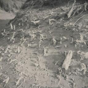
One of a collection of over 400 photographs in an album commenced in 1960 and presented to the Phillip Island & Westernport Historical Society by the Shire of Phillip IslandPhotograph of calcareous moulds formed by early forms of vegetation and subsequent action of wind and sand.local history, photography, calcareous moulds, black & white photograph, coastline, dunes, john jenner, bryant west -
Koorie Heritage Trust
Book, Breidahl, Harry, A guide to Point Nepean's past, 1992
Contents: Ice ages & sand dunes; Koories & the Great Flood; European Settlers; Limeburning; Ships & Shipwrecks; Fear of fever; The quarantine station; Protecting the Colony; Point Nepean Forts; Manning the Forts; Guns that disappeared; Mark VII Guns; First Shots; Exploring Point Nepean.32 p. : ill. ; maps; 17 x 24 cm.Contents: Ice ages & sand dunes; Koories & the Great Flood; European Settlers; Limeburning; Ships & Shipwrecks; Fear of fever; The quarantine station; Protecting the Colony; Point Nepean Forts; Manning the Forts; Guns that disappeared; Mark VII Guns; First Shots; Exploring Point Nepean.point nepean-history, point nepean-kooris-history -
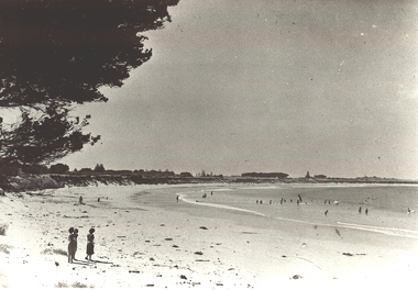 Port Fairy Historical Society Museum and Archives
Photograph
Black and white Photograph of the East Beach looking North from Battery Lane with people bathing in the middle groundeast beach, ocean, beach, sea, dunes