Showing 1510 items matching "east side"
-
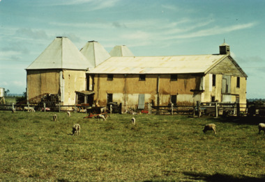
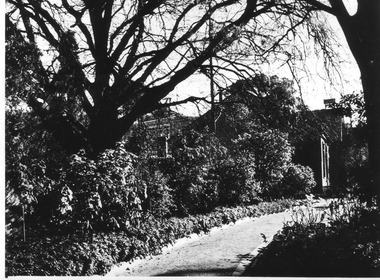
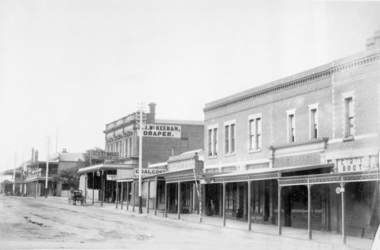
![Photograph, Sussex Street, Linton - east side, Library to Bennett's Garage, including weighbridge, undated [1930s?]](/media/collectors/5d8bf68021ea67123cb0cc12/items/68ce1a0aa33a5972d3391949/item-media/68ce1c23a33a5972d3395d43/item-fit-380x285.jpg?cb=6) Linton and District Historical Society Inc
Linton and District Historical Society IncPhotograph, Sussex Street, Linton - east side, Library to Bennett's Garage, including weighbridge, undated [1930s?]
... Sussex Street, Linton - east side, Library to Bennett's Garage, including weighbridge, undated [1930s?]...East side Sussex Street Linton...Photograph is thought to have been taken after 1932, as it depicts Bennett's Garage, built 1928, and also Murrell's Newsagency, which moved into premises on the east side of Sussex Street in 1932....Black and white copy of original photograph, showing east side of Sussex Street between public library building and Bennett's Garage....Linton and District Historical Society Inc 69 Sussex Street Linton 3360 goldfields Photograph is thought to have been taken after 1932, as it depicts Bennett's Garage, built 1928, and also Murrell's Newsagency, which moved into premises on the east side of Sussex Street in 1932. East side Sussex Street Linton Linton Public Library Railway Hotel Murrell's Newsagency Linton Weighbridge Bennett's Garage Black and white copy of original photograph, showing east side of Sussex Street between public library building and Bennett's Garage. ...Photograph is thought to have been taken after 1932, as it depicts Bennett's Garage, built 1928, and also Murrell's Newsagency, which moved into premises on the east side of Sussex Street in 1932.Black and white copy of original photograph, showing east side of Sussex Street between public library building and Bennett's Garage.east side sussex street linton, linton public library, railway hotel, murrell's newsagency, linton weighbridge, bennett's garage -
 Linton and District Historical Society Inc
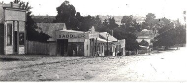
Photograph, Sussex Street, Linton, east side between Craine's confectionery shop and Preston's shop, undated (1920s?)
... Sussex Street, Linton, east side between Craine's confectionery shop and Preston's shop, undated (1920s?)...East side Sussex Street Linton...Black and white copy of original photograph, which shows the east side of Sussex Street, Linton, between Jane Craine's confectionery shop and Preston's shop on the corner of Sussex and Gillespie Streets. ...Sussex Street, Linton, east side between Craine's confectionery shop and Preston's shop, undated (1920s?) ...Photograph was printed from a glass negative loaned by Theo Nelson. It shows Jane Craine's confectionery shop, Patrick O'Sullivan's saddlery, G. G. Bennett's butcher's shop, Nicol's bakery, Wise's drapery shop, and Preston's store. The cottage which can be seen in the background of the photograph was lived in by Joe Lambley.Black and white copy of original photograph, which shows the east side of Sussex Street, Linton, between Jane Craine's confectionery shop and Preston's shop on the corner of Sussex and Gillespie Streets. east side sussex street linton, jane craine's confectionery shop, patrick o'sullivan saddlery sussex street linton., g.g. bennett bucher's shop, nicol's bakery, wise's drapery, preston's store -
 Canterbury History Group
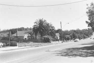
Photograph - New carpark east side of Bryson Street
... New carpark east side of Bryson Street...New carpark east side of Bryson Street opposite IGA Supermarket...New carpark east side of Bryson Street opposite IGA Supermarket Colour photograph Photograph New carpark east side of Bryson Street Jan Pigot ...Colour photographnew carpark east side of bryson street opposite iga supermarket -
 Ballaarat Mechanics' Institute (BMI Ballarat)
Armstrong St Nth East side
... Armstrong St Nth East side......east side...Ballarat Armstrong st nth east side town hall Armstrong St Nth East side ...This photograph is from the Max Harris Collection held by the Ballaraat Mechanics' Institute. Please contact BMI for all print and usage inquiries.ballarat, armstrong st nth, east side, town hall -
 Ringwood and District Historical Society
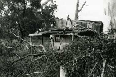
Photograph-B&W, Wantirna Road Shack next to Dandenong Creek on East Side of Wantirna Road (near the bridge), 6/07/1989
... Wantirna Road Shack next to Dandenong Creek on East Side of Wantirna Road (near the bridge)....Wantirna Road Shack next to Dandenong Creek on East Side of Wantirna Road (near the bridge). ...A shack next to Dandenong Creek / East side of Wantirna Road / Has been there many years - maybe 40 / It is still there (18.9.89)...Ringwood and District Historical Society 125A Warrandyte Road Ringwood North melbourne A shack next to Dandenong Creek / East side of Wantirna Road / Has been there many years - maybe 40 / It is still there (18.9.89) Wantirna Road Shack next to Dandenong Creek on East Side of Wantirna Road (near the bridge). ...Wantirna Road Shack next to Dandenong Creek on East Side of Wantirna Road (near the bridge). Has been there many years - maybe 40 and it is still there (18.9.1989). (Note this is NOT part of Hill's dairy but was in the same series of photographs so kept together).A shack next to Dandenong Creek / East side of Wantirna Road / Has been there many years - maybe 40 / It is still there (18.9.89) -
Port Melbourne Historical & Preservation Society
Photograph - Kiosk, east side Station Pier, Port Melbourne, Pat Grainger, 1988 - 1990s
... Kiosk, east side Station Pier, Port Melbourne...East side kiosk on Station Pier in original position...Port Melbourne Historical & Preservation Society Port Melbourne Town Hall 333 Bay Street Port Melbourne melbourne piers and wharves - station pier East side kiosk on Station Pier in original position Photograph Kiosk, east side Station Pier, Port Melbourne Pat Grainger ...East side kiosk on Station Pier in original positionpiers and wharves - station pier -
 Port Melbourne Historical & Preservation Society
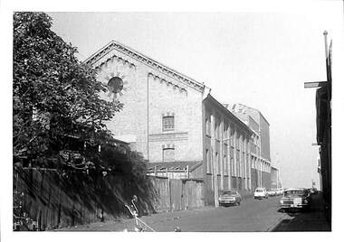
Photograph - Post Office Place, east side, Port Melbourne, Janet and Allen Walsh, 1973
... Post Office Place, east side, Port Melbourne, ...Post Office Place, east side. Shows rear of Harpers Oriental Mill on left. 1973 ...Port Melbourne Historical & Preservation Society Port Melbourne Town Hall 333 Bay Street Port Melbourne melbourne Shot in 1973 with particular interest in architecture Harpers Oriental Mill Post Office Place Built Environment - Industrial Janet WALSH Allen WALSH Identified and dated on back in ink Post Office Place, east side. Shows rear of Harpers Oriental Mill on left. 1973 Photograph Post Office Place, east side, Port Melbourne, Janet and Allen Walsh ...Shot in 1973 with particular interest in architecturePost Office Place, east side. Shows rear of Harpers Oriental Mill on left. 1973 Identified and dated on back in inkharpers oriental mill, post office place, built environment - industrial, janet walsh, allen walsh -
 Lakes Entrance Historical Society
Photograph - Hop Kilns on Silt Jetties Road east side of Mitchell River Bairnsdale 1970, M Fish
... Hop Kilns on Silt Jetties Road east side of Mitchell River Bairnsdale 1970...Colour photograph of Hop Kilns on Silt Jetties Road east side of Mitchell River Bairnsdale Victoria...Built for James Taylor in 1882 Madres Field Hop Kilns Industry Colour photograph of Hop Kilns on Silt Jetties Road east side of Mitchell River Bairnsdale Victoria Photograph Hop Kilns on Silt Jetties Road east side of Mitchell River Bairnsdale 1970 M Fish ...These hop kilns have since been destroyed by fire. Jubler was Architect of building, John French and Co Contractors. Built for James Taylor in 1882 Madres Field Hop KilnsColour photograph of Hop Kilns on Silt Jetties Road east side of Mitchell River Bairnsdale Victoriaindustry -
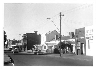 Port Melbourne Historical & Preservation Society
Photograph - 324-364 Bay Street, east side from Behan & Speed to Spring Street corner, Port Melbourne, Janet and Allen Walsh, 1973
... 324-364 Bay Street, east side from Behan & Speed to Spring Street corner, Port Melbourne...Set of 31 photographs taken in June and July 1973 Bay st, east side from Bridge St...Port Melbourne Historical & Preservation Society Port Melbourne Town Hall 333 Bay Street Port Melbourne melbourne Shot in 1973 with particular interest in architecture Janet WALSH Allen WALSH Built Environment - Commercial Built Environment - Domestic Bay Street Bridge Street Identified and dated on back in ink Set of 31 photographs taken in June and July 1973 Bay st, east side from Bridge St Photograph 324-364 Bay Street, east side from Behan & Speed to Spring Street corner, Port Melbourne Janet and Allen Walsh ...Shot in 1973 with particular interest in architectureSet of 31 photographs taken in June and July 1973 Bay st, east side from Bridge StIdentified and dated on back in inkjanet walsh, allen walsh, built environment - commercial, built environment - domestic, bay street, bridge street -
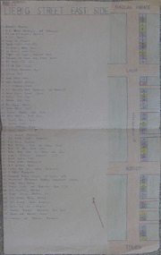 Warrnambool and District Historical Society Inc.
Document - Assignment: Liebig Street –East side, Circa 1951
... Assignment: Liebig Street –East side ...Provides a comprehensive list of businesses on the east side of Warrnambool’s main street in the mid 20th century. ...Document Assignment: Liebig Street –East side ...Provides a comprehensive list of businesses on the east side of Warrnambool’s main street in the mid 20th century. An example of school work at the time as well as contributing to local historical knowledge.A3 fawn coloured paper with numbered list of businesses handwritten in blue down left hand side and corresponding numbers positioned on coloured diagram down right hand side. Area covered is from Raglan Parade to Timor Street.Beris Henderson Form 1 Bwarrnambool, liebig street, koroit street, lava street, raglan parade, timor street -
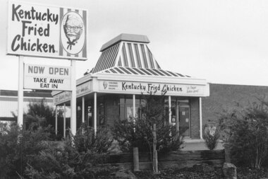 Ringwood and District Historical Society
Photograph, Kentucky Fried Chicken, Whitehorse Rd, East side, Ringwood. Probably 1982
... Kentucky Fried Chicken, Whitehorse Rd, East side, Ringwood. Probably 1982...Catalogue card reads, "Kentucky Fried Chicken, Whitehorse Rd, East side."...Kentucky Fried Chicken, Whitehorse Rd, East side, Ringwood. Probably 1982 Photograph ...Undated, but others in the SS036 series are 1982.Catalogue card reads, "Kentucky Fried Chicken, Whitehorse Rd, East side." -
 Ringwood and District Historical Society
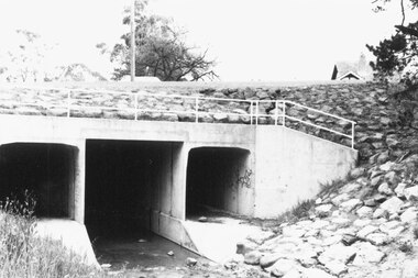
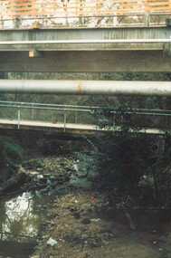
Photograph, Warrandyte Rd. culvert upstream (East) side. Ringwood 1987
... Warrandyte Rd. culvert upstream (East) side. Ringwood 1987...Warrandyte Rd. culvert upstream (East) side."...Warrandyte Rd. culvert upstream (East) side." Warrandyte Rd. culvert upstream (East) side. ...Written on back of photograph, "13.4.87. Warrandyte Rd. culvert upstream (East) side." -
 Buninyong & District Historical Society
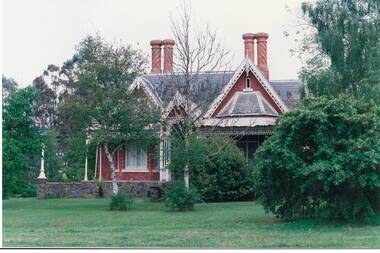
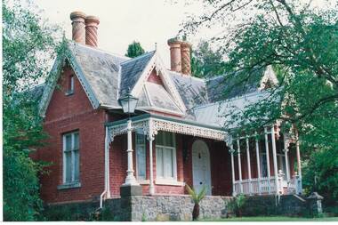
Photograph - Original Photograph, Clifton Villa (1859) Eyre St. Buninyong, front (east side), full on, 9/11/1991
... Buninyong, front (east side), full on....Buninyong, front (east side)....Buninyong, front (east side). Clifton Villa (1859) Eyre St. Buninyong, front (east side), full on. ...historic building, after restorationColour photograph, Clifton Villa (1859) Eyre St. Buninyong, front (east side).buninyong, clifton villa, chimney -
 Whitehorse Historical Society Inc.
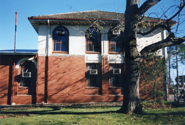
Photograph, East side of former Municipal Chambers, Nunawading, 1/06/1997 12:00:00 AM
... East side of former Municipal Chambers, Nunawading....Coloured photo of East side of former Municipal Chambers of 360 Whitehorse Road, Nunawading....East side of former Municipal Chambers, Nunawading. ...Coloured photo of East side of former Municipal Chambers of 360 Whitehorse Road, Nunawading.municipal chambers, shire of blackburn and mitcham, city of nunawading, whitehorse road, nunawading, no.360 -
 Whitehorse Historical Society Inc.
Photograph, East side of former Municipal Chambers, Nunawading, 1/06/1997 12:00:00 AM
... East side of former Municipal Chambers, Nunawading....Coloured photo of East side of former Municipal Chambers at 360 Whitehorse Road, Nunawading....East side of former Municipal Chambers, Nunawading. ...Coloured photo of East side of former Municipal Chambers at 360 Whitehorse Road, Nunawading.municipal chambers, shire of blackburn and mitcham, city of nunawading, whitehorse road, nunawading, no. 360 -
 University of Melbourne, Burnley Campus Archives
Photograph - Black and white print, E.M. Gibson, View of East Side of Administration Building, 18 July 1948
... View of East Side of Administration Building...Black and white photograph. View of east side of Administration Building. Shrubs and trees and a path....View of East Side of Administration Building Photograph Black and white print E.M. ...Black and white photograph. View of east side of Administration Building. Shrubs and trees and a path."18/7/48."648/6 21administration building, e. m. gibson collection, garden view -
 Ringwood and District Historical Society
Photograph, Warrandyte Road, east side, to Aird Street and bowling green. Jan. 1975
... Warrandyte Road, east side, to Aird Street and bowling green. ...Written on back of photograph, "Warrandyte Road, east side, to Aird Street and bowling green. ...Warrandyte Road, east side, to Aird Street and bowling green. ...Written on back of photograph, "Warrandyte Road, east side, to Aird Street and bowling green. Jan. 1975". -
 Whitehorse Historical Society Inc.
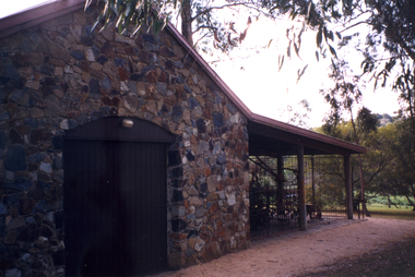
Photograph, East side of Museum
... East side of Museum...Coloured photograph of east side of Museum showing large double doors and corner of implement shed....East side of Museum Photograph Photograph ...Coloured photograph of east side of Museum showing large double doors and corner of implement shed.schwerkolt cottage & museum complex, nunawading & district historical society -
 Buninyong & District Historical Society
Photograph - Original Photograph, Clifton Villa (1859) Eyre St. Buninyong, front (east side), 9/11/1991
... Buninyong, front (east side)....Buninyong, front (east side), 3/4 view....Buninyong, front (east side). Photograph Original Photograph ...historic building, after restorationColour photograph, Clifton Villa (1859) Eyre St. Buninyong, front (east side), 3/4 view.buninyong, clifton villa, chimney -
 Buninyong & District Historical Society
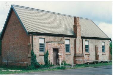
Photograph - Original Photograph, Clive Brooks, Original Anglican Church/Common School (1857), east side, 9 Nov. 1991
... Original Anglican Church/Common School (1857), east side....Colour photo Original Holy Trinity Anglican Church/Common School (April 1857), east side. Part of tennis court visible in foreground, with net and umpire's stand....Original Anglican Church/Common School (1857), east side. Photograph Original Photograph Clive Brooks ...detail of historic buildingColour photo Original Holy Trinity Anglican Church/Common School (April 1857), east side. Part of tennis court visible in foreground, with net and umpire's stand.buninyong, holy trinity, tennis court, anglican, church, common school -
 Whitehorse Historical Society Inc.
Photograph, View east side Mitcham Road, c. 1987
... View east side Mitcham Road...Black and white photograph of the east side Mitcham Road, opposite Victoria Street, showing the office block, now (in 2004) occupied by Jobs East. c. 1987|See History...Black and white photograph of the east side Mitcham Road, opposite Victoria Street, showing the office block, now (in 2004) occupied by Jobs East. c. 1987|See History View east side Mitcham Road Photograph Photograph ...The site was the former medical rooms of Dr Stanley Cochrane and Dr Vernier ThrelkeldBlack and white photograph of the east side Mitcham Road, opposite Victoria Street, showing the office block, now (in 2004) occupied by Jobs East. c. 1987|See Historymitcham road, mitcham, victoria street, cochrane . stanley dr, threlkeld, verner w. dr. -
 Greensborough Historical Society
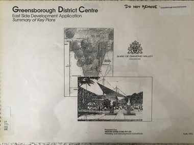
Plan - Application, Wilson Sayer Core Pty Ltd, Greensborough District Centre: East side development application: summary of key plans. 1992, 1992_04
... Greensborough District Centre: East side development application: summary of key plans. 1992....A summary of the plans for the Greensborough District Centre from 1992, with plans for the development of the East side of Main Street Greensborough....Greensborough District Centre: East side development application: summary of key plans. 1992. ...A summary of the plans for the Greensborough District Centre from 1992, with plans for the development of the East side of Main Street Greensborough.16 pages. Black and white line drawings and plans. Has plastic cover and wire binding. greensborough district centre, main street greensborough -
 Ringwood and District Historical Society
Photograph, Ringwood, Mullum Mullum Creek, east side. Warrandyte Road Bridge. 1986
... Ringwood, Mullum Mullum Creek, east side. Warrandyte Road Bridge. 1986...Ringwood, Mullum Mullum Creek, east side. Warrandyte Road Bridge"....Ringwood, Mullum Mullum Creek, east side. Warrandyte Road Bridge". Ringwood, Mullum Mullum Creek, east side. ...Written on backing sheet, "Bridge, Mullum Rd. Completed May 1987." Writing on back of photograph reads, "Aug., 1986. Ringwood, Mullum Mullum Creek, east side. Warrandyte Road Bridge". -
 Greensborough Historical Society
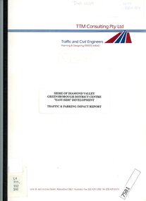
Booklet - Report, TTM Consulting Pty Ltd, Shire of Diamond Valley: Greensborough District Centre: "East-side" development application: traffic & parking impact report, 1992, 1992_04
... Shire of Diamond Valley: Greensborough District Centre: "East-side" development application: traffic & parking impact report, 1992....A summary of traffic ad parking impacts of the Greensborough District Centre in 1992, with plans for the development of the East side of Main Street Greensborough....Shire of Diamond Valley: Greensborough District Centre: "East-side" development application: traffic & parking impact report, 1992. ...A summary of traffic ad parking impacts of the Greensborough District Centre in 1992, with plans for the development of the East side of Main Street Greensborough.14 pages text and 11 pages black and white line drawings. greensborough district centre, main street greensborough, traffic, parking -
 Buninyong & District Historical Society
Photograph - Original B/W Photograph, Clive Brooks, Warrenheip St Buninyong, east side, between Forest and Learmonth, 18/9/1993
... Warrenheip St Buninyong, east side, between Forest and Learmonth, ...B/W photo, Warrenheip St Buninyong, east side, between Forest and Learmonth, former Eagle Hotel at centre, Former National Bank far right, Town Hall Tower visible in background. ...Warrenheip St Buninyong, east side, between Forest and Learmonth, Photograph Original B/W Photograph Clive Brooks ...Record of central Buninyong 1993B/W photo, Warrenheip St Buninyong, east side, between Forest and Learmonth, former Eagle Hotel at centre, Former National Bank far right, Town Hall Tower visible in background. buninyong, warrenheip st., eagle hotel, national bank -
 Linton and District Historical Society Inc
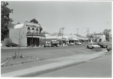
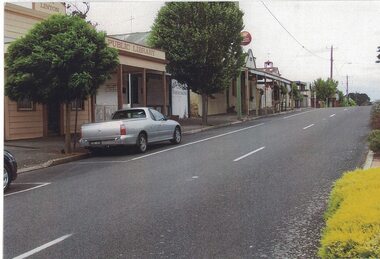
Photograph, East Side of Sussex Street, Linton, 2014
... East Side of Sussex Street, Linton, 2014...The photograph shows the view to the south along the east side of Sussex Street. The former public library building, the Historical Society building (formerly Nelson Bros Undertakers), the Railway Hotel, the former CFA building and other shops and houses can be seen on the left of the photograph, which was taken by Gary Hunt in 2014....East Side of Sussex Street, Linton, 2014 Photograph ...One of three colour photographs which have been printed on a single sheet of photographic paper. The photograph shows the view to the south along the east side of Sussex Street. The former public library building, the Historical Society building (formerly Nelson Bros Undertakers), the Railway Hotel, the former CFA building and other shops and houses can be seen on the left of the photograph, which was taken by Gary Hunt in 2014.linton public library building, linton & district historical society resource centre building, railway hotel linton, cfa building linton, sussex street linton -
 Sunshine and District Historical Society Incorporated
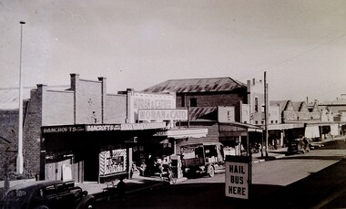
Photograph - Hampshire Rd East Side Between Devonshire Rd And Dickson St Photograph
... Hampshire Rd East Side Between Devonshire Rd And Dickson St Photograph...Hampshire Road Sunshine Bancrofts Pty Ltd Moran and Cato Library Black & white photograph Photograph Hampshire Rd East Side Between Devonshire Rd And Dickson St Photograph ...hampshire road, sunshine, bancrofts pty ltd, moran and cato, library -
 Ballaarat Mechanics' Institute (BMI Ballarat)
East Side Doveton St Nth
... East Side Doveton St Nth...Ballarat doveton East Side Doveton St Nth ...This photograph is from the Max Harris Collection held by the Ballaraat Mechanics' Institute. Please contact BMI for all print and usage inquiries.ballarat, doveton -
 Tarnagulla History Archive
Polaroid photograph: Buildings on east side Commercial Road, Tarnagulla
... Polaroid photograph: Buildings on east side Commercial Road, Tarnagulla...Polaroid photograph: Buildings on east side Commercial Road, Tarnagulla Stokes & Son ...David Gordon Collection. -
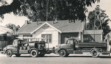 Eltham District Historical Society Inc
Photograph, Hugh Fisher, Eltham Fire Station, east side of Main Road, 1950s, 1950s
... Eltham Fire Station, east side of Main Road, 1950s...The Research Scout Hall was destroyed by fire in 2002. eltham fire station Main Road Photo by Hugh Fischer, c.1950s Black and white photograph Eltham Fire Station, east side of Main Road, 1950s Photograph Photograph Hugh Fisher ...The Eltham Fire Station was opened in 31 April 1935. Years later the building was removed and erected for use of 1st Research Scout Group in Research Park by the early 1970s to make way for the Eltham Village Complex which was under construction by 1971. The Research Scout Hall was destroyed by fire in 2002.Black and white photographPhoto by Hugh Fischer, c.1950seltham, fire station, main road