Showing 106 items matching "electricity lines"
-
 Eltham District Historical Society Inc
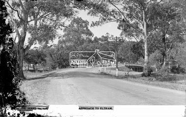
Negative - Photograph postcard, The Rose Stereograph Company, Approach To Eltham, c.1939
... ...electricity lines...The Cutts family understands that for these historically important pieces to rest with one family is to deny others the pleasure of their custodianship. buildings electricity lines eltham postcard travel rose stereograph company valentine series postcard main road bridge glass plate negative main road Peter and Elizabeth Pidgeon Collection Diamond Creek (Creek) Eltham South Rose Stereograph Approach to Eltham, Valentine Series No. 3197, Copyright Glass Plate Negative Size: 9 x 14 cm Approach To Eltham Negative Photograph postcard The Rose Stereograph Company Lloyds Auctioneers and Valuers Peter Pidgeon ...Looking east along the unsealed main road heading into Eltham across the concrete bridge over the Diamond Creek circa 1939. The original wooden bridge was destroyed by flood waters in 1924. This glass plate negative was used to manufacture postcards (1:1 printing) for commercial sale by the Rose Sterograph Company and its subsidiaries. George Rose founded the Rose Stereograph Company in 1880 and was joined by Herbert (Bert) Cutts in the early 20th Century. The pair formed a lifetime working partnership and strong personal friendship. Assisted by George’s two sons, Herbert George and Walter, and later by Neil Cutts, the Rose Stereograph Company continued its operations for more than 140 years. The company was initially built on stereographs, but as cinema took over and stereographs fell out of fashion, the Rose Stereograph Company developed Australia’s first commercially viable photographic postcard business. Specialising in postcards of iconic historical moments and significant landmarks, The Rose Stereograph Company became a staple of the Australian travel industry.This remarkable collection of glass plate negatives, transparencies, and postcards – arguably Australia’s most significant photography collection outside of public hands – has been passed down through the generations, surviving war, relocation, and the harsh Victorian climate. The historic Rose Stereograph collection is the culmination of George Rose’s dream of capturing and preserving precious moments in time and remains the legacy of the Rose and Cutts families. It is with great sadness that the Cutts family says goodbye to a collection that spans five generations and 140 years. The Cutts family understands that for these historically important pieces to rest with one family is to deny others the pleasure of their custodianship.Glass Plate Negative Size: 9 x 14 cmApproach to Eltham, Valentine Series No. 3197, Copyrightbuildings, electricity lines, eltham, postcard, travel, rose stereograph company, valentine series postcard, main road bridge, glass plate negative, main road, peter and elizabeth pidgeon collection, diamond creek (creek), eltham south, rose stereograph -
 Eltham District Historical Society Inc
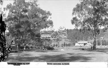
Photograph, The Rose Stereograph Company, Picnic Grounds. Eltham, Vic, c.1939
... ...electricity lines...The Cutts family understands that for these historically important pieces to rest with one family is to deny others the pleasure of their custodianship. eltham lower park cricket cars buildings electricity lines lower plenty eltham postcard travel picnic ground rose stereograph company valentine series postcard glass plate negative Peter and Elizabeth Pidgeon Collection Picnic Grounds, Eltham, Valentine Series No. 3195, Copyright Glass Plate Negative Size: 9.2 x 13.9 cm Picnic Grounds. ...View looking north parallel to present-day Hohnes Road in Eltham Park (Eltham Lower Park) towards the intersection of Old Eltham Road and Main Road. In those days Eltham Park consisted of a single oval with a cricket pitch running north south in much the same position as today’s oval closest to Main Road. An unsealed track ran around the perimeter of park, essentially bisecting today’ rear oval and horse paddock. Picnickers have pulled up in their cars and are enjoying a game of cricket being played on the oval. This glass plate negative was used to manufacture postcards (1:1 printing) for commercial sale by the Rose Stereograph Company and its subsidiaries. George Rose founded the Rose Stereograph Company in 1880 and was joined by Herbert (Bert) Cutts in the early 20th Century. The pair formed a lifetime working partnership and strong personal friendship. Assisted by George’s two sons, Herbert George and Walter, and later by Neil Cutts, the Rose Stereograph Company continued its operations for more than 140 years. The company was initially built on stereographs, but as cinema took over and stereographs fell out of fashion, the Rose Stereograph Company developed Australia’s first commercially viable photographic postcard business. Specialising in postcards of iconic historical moments and significant landmarks, The Rose Stereograph Company became a staple of the Australian travel industry.This remarkable collection of glass plate negatives, transparencies, and postcards – arguably Australia’s most significant photography collection outside of public hands – has been passed down through the generations, surviving war, relocation, and the harsh Victorian climate. The historic Rose Stereograph collection is the culmination of George Rose’s dream of capturing and preserving precious moments in time and remains the legacy of the Rose and Cutts families. It is with great sadness that the Cutts family says goodbye to a collection that spans five generations and 140 years. The Cutts family understands that for these historically important pieces to rest with one family is to deny others the pleasure of their custodianship.Glass Plate Negative Size: 9.2 x 13.9 cmPicnic Grounds, Eltham, Valentine Series No. 3195, Copyrighteltham lower park, cricket, cars, buildings, electricity lines, lower plenty, eltham, postcard, travel, picnic ground, rose stereograph company, valentine series postcard, glass plate negative, peter and elizabeth pidgeon collection -
 Kiewa Valley Historical Society
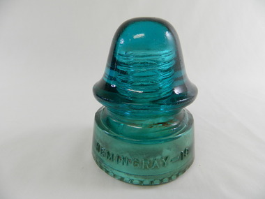
Insulator - Glass x2
... kiewa hydro electric scheme. electricity. power lines. insulator...Used on the power poles in the Kiewa Valley. kiewa hydro electric scheme. electricity. power lines. insulator Green one has 'Agee' on side of the open end Clear tinted glass (one green & one brown) domed shaped insulator. ...Insulates electrical wire which is attached between the outside ridges. It is screwed onto the cross arm of a power pole. It is non conductive so electricity doesn't short to the ground.Used on the power poles in the Kiewa Valley.Clear tinted glass (one green & one brown) domed shaped insulator. Above centre there are 2 ridges to enable the electrical wire/cable to be fixed on. The closed end has a screw thread down to half way to enable it to be attached to a pole.Green one has 'Agee' on side of the open endkiewa hydro electric scheme. electricity. power lines. insulator -
 Kiewa Valley Historical Society
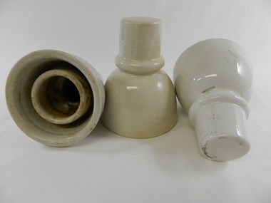
Insulator - Porcelain
... kiewa hydro electric scheme. electricity. power lines. insulator...Used on power poles in the Kiewa Valley. kiewa hydro electric scheme. electricity. power lines. insulator On the side of the closed end - "KP / 64" Cream coloured porcelain cylindrical shaped insulator with a groove towards the narrower closed end. ...Insulates electrical wire which is attached in the groove towards the narrow end. It is screwed onto the cross arm of a power pole. Non conductive so that electricity doesn't short out to the ground.Used on power poles in the Kiewa Valley.Cream coloured porcelain cylindrical shaped insulator with a groove towards the narrower closed end. Inside the narrow end it is threaded for screwing.On the side of the closed end - "KP / 64"kiewa hydro electric scheme. electricity. power lines. insulator -
 Kiewa Valley Historical Society
Insulator - Porcelain small x3
... kiewa hydro electric scheme. electricity. power lines. insulator....Used on power poles in the Kiewa Valley. kiewa hydro electric scheme. electricity. power lines. insulator. White porcelain bell shaped insulator with an indent between the wide open end and the narrow closed end. ...Insulates electrical wire/cable which is attached between the narrow and wide ends of the 'bell' shape (in the groove). Screwed onto the cross arm of a power pole. Non conductive so electricity doesn't short out to the ground.Used on power poles in the Kiewa Valley.White porcelain bell shaped insulator with an indent between the wide open end and the narrow closed end. The indent is for the wire/cable to be attached. The wide end is open with a white porcelain cylinder inside narrowing to thread for screwing, in the narrow section. kiewa hydro electric scheme. electricity. power lines. insulator. -
 Kiewa Valley Historical Society
Insulator - Porcelain large x3
... kiewa hydro electric scheme. electricity. power lines. insulator....Used on power poles in the Kiewa Valley. kiewa hydro electric scheme. electricity. power lines. insulator. White porcelain bell shaped insulator with an indent between the wide open end and the narrow closed end (for cable to be attached). ...Insulates electrical wire/cable which is attached between narrow and wide ends of the 'bell' shape (in a groove). Screwed onto the cross arm of a power pole. Non conductive so electricity doesn't short out to the ground. Used on power poles in the Kiewa Valley.White porcelain bell shaped insulator with an indent between the wide open end and the narrow closed end (for cable to be attached). The wide end is open with a white porcelain cylinder inside narrowing to thread for screwing in the narrow section.kiewa hydro electric scheme. electricity. power lines. insulator. -
 Kiewa Valley Historical Society
Insulator - Glass
... electricity. power lines. insulator. hemingray....Used on power poles in the Kiewa Valley electricity. power lines. insulator. hemingray. "Hemingray - 19" "Made in U.S.A." ...Insulates electrical wire/cable which is attached in the groove. Screwed into the cross arm of a power pole. Non conductive so electricity doesn't short out to the ground.Used on power poles in the Kiewa ValleyClear blue tinted glass insulator - bell shaped at the closed end. Deep, wide groove towards the wide open end. The wide end is inscribed and opens to a decorated edge of small balls around the circumference. Inside there is a cylinder which is threaded for screwing onto a power pole. This cylinder is shorter than the outside part."Hemingray - 19" "Made in U.S.A."electricity. power lines. insulator. hemingray. -
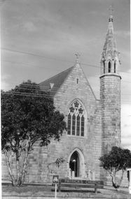 Stawell Historical Society Inc
Photograph, St. Patrick’s Catholic Church c 1965-1970
... The other photo of the church taken at a different angle shows two trees and a church sign out the front. Electricity lines can be seen across the photo....The other photo of the church taken at a different angle shows two trees and a church sign out the front. Electricity lines can be seen across the photo. St. ...Views of St. Patrick’s Catholic Church. Two of the photos are identical showing the parish hall on left of photo and a small part of priest's residence on right. A car can be seen parked below the church fence. Photo recorded to be taken by Ruby Willy Estate. The other photo shows a different view with a timber sign out the front of the church and two trees either side of the sign. This third photo also just shows the priests house on the right and taken around 1965 -1970.Three black and white photos of St Patrick's Church. Two are identical showing parish Hall on left of photo and small part of priest's residence on right. The other photo of the church taken at a different angle shows two trees and a church sign out the front. Electricity lines can be seen across the photo.stawell -
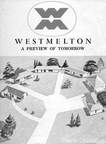 Melton City Libraries
Document, West Melton: A preview of tomorrow, c.1969
... Westmelton was also the first major development in Victoria to build all the supply lines to the houses – including electricity and telephone lines – underground. ...Westmelton was also the first major development in Victoria to build all the supply lines to the houses – including electricity and telephone lines – underground. ..."In April 1969, the first major residential development in Melton began with the release of 148 homes for purchase. This was the first stage of a staggered release of a planned 30,000 homes for 100,000 people by 1990. The development, called Westmelton Satellite City, was described as ‘a preview of tomorrow’.101 It was the first estate built in a ‘modern’ style, with curved streets, and dozens of culs de sac. Westmelton was also the first major development in Victoria to build all the supply lines to the houses – including electricity and telephone lines – underground. The six different home designs in Westmelton were ‘specially designed for the future’, and with allotments ten feet wider than regulations required, there was plenty of ‘space for gracious living’ and for a family swimming pool. The developers of this new estate were active in promoting Westmelton as a new community within the Shire of Melton. By 1971, the Westmelton City News reported that Ian McIntosh, General Manager of Westmelton, had given away $100,000 on behalf of the company ‘to aid community projects’. This included a $72,000 donation towards building a community centre in Westmelton, and $25,000 for the shire’s Olympic-sized swimming pool. Ian McIntosh and his family moved to Melton and Ian said he was ‘very much aware of the needs of [the] Westmelton community’. By the end of 1971, Westmelton was home to 100 new families. The modern residences were obviously an appealing drawcard, but so was the country feel that characterised Melton. Mrs C. Allen, described as a ‘housewife’, said she and her husband chose to move to Westmelton because of ‘the quality homes ... and we both love the clean, fresh, natural environment that surrounds us’. Similarly, Mr W. Coxhead, insurance consultant, moved to Westmelton because of the ‘clean, fresh country air’. Accountant Mr B. Swanton echoed their sentiments, describing Westmelton as ‘far enough away from the industrial pollution carried over Melbourne suburbs by prevailing westerly winds’. The new development attracted an increasing number of young, professional couples and families, representing the beginning of a significant shift from the predominantly rural and farming community of the district’s past. The Westmelton development had four different ‘neighbourhoods’ designed to cater to a variety of different lifestyle needs. Westmelton was the first to be established, followed by Brookfield, which offered ‘superb land in a rustic setting’. Brookfield Acres offered ‘wide open spaces with lots of room for a pool and even a tennis court’ on huge one-acre blocks, while Westlake was an innovative development with ‘different sized homesites’ and ‘lakeside living’.Westmelton was the first of many residential developments that would come to play a huge role in shaping the shire in the decades to follow".A marketing brochure for the Westmelton Satellite City developmentlocal significant events, council -
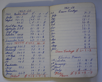 Warrnambool and District Historical Society Inc.
Financial record - Bonnett Farm Account Notebook, George Bonnett, Mepunga, 1920 to 1981
... electricity bills, garage repairs, stock feed, household goods etc. This notebook is an interesting memento of Westen District farm finances over a period of sixty years in the 20th century Mepunga Farming Bonnett Family of Mepunga This is a small note book with a black cover. It contains pages with ruled lines ...This is a notebook used to keep some of the farm accounts of the Bonnett farm in Mepunga. As the handwriting is the same throughout, most of the entries appear to have been made by George Bonnett, the son of Frederick and Charity Bonnett. The accounts date from 1920 to 1981 and commence with the sale of stock (pigs, sheep and cattle) in 1920 and go on to record purchases as well as sales in a variety of goods and services - cartage costs, electricity bills, garage repairs, stock feed, household goods etc. This notebook is an interesting memento of Westen District farm finances over a period of sixty years in the 20th centuryThis is a small note book with a black cover. It contains pages with ruled lines and handwritten entries in red, blue and black ink. Some pages have been cut out at the back of the book.mepunga farming, bonnett family of mepunga -
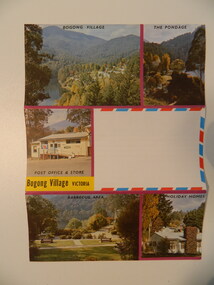 Kiewa Valley Historical Society
Postcard - Bogong Village x2
... Electricity Commission of Victoria sold it upon the completion of the Kiewa Hydro Electric Scheme. Bogong Village was built by the SEC as a town for its employees on the Kiewa Hydro Electric Scheme. This card represents the village in later years when it was being promoted as a holiday resort. bogong village tourism Cover: 5 colored photos of Bogong Village with a blank space for writing the address and affixing the postage stamp. Other side is covered with horizontal parallel lines ...Bogong Village became a tourist town after the State Electricity Commission of Victoria sold it upon the completion of the Kiewa Hydro Electric Scheme.Bogong Village was built by the SEC as a town for its employees on the Kiewa Hydro Electric Scheme. This card represents the village in later years when it was being promoted as a holiday resort.Cover: 5 colored photos of Bogong Village with a blank space for writing the address and affixing the postage stamp. Other side is covered with horizontal parallel lines on which to write. Paper is made to fold into three with gum at the top to seal.bogong village, tourism -
 Kiewa Valley Historical Society
Papers - Kiewa Hydro Electric Scheme, State Electricity Commission of Victoria / Kiewa Hydro Electric Project / Progress of the Undertaking, November 1953
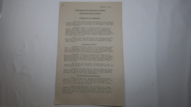
... lines as well as camps, towns, roads, telecommunications and infra structure. These papers give an understanding of where the project was up to in late 1953. These papers give information on the KHES on the aspects of work, its progress and technical detail. state electricity commission of victoria; kiewa hydro electric scheme; power stations; dams; tunnels; bogong high plains 3 foolscap pages, stapled in the top left hand corner. ...The SECV constructed the KHES from 1939 to 1961 on the Bogong High Plains. It included work on Power Stations, Dams, Tunnels, Race-lines and transmission lines as well as camps, towns, roads, telecommunications and infra structure. These papers give an understanding of where the project was up to in late 1953. These papers give information on the KHES on the aspects of work, its progress and technical detail.3 foolscap pages, stapled in the top left hand corner. Each page has sub headings re the progress of the works being undertaken on the Kiewa Hydro Electric Scheme.state electricity commission of victoria; kiewa hydro electric scheme; power stations; dams; tunnels; bogong high plains -
 Kiewa Valley Historical Society
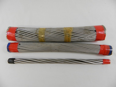
S.E.C.V. Transmission Cables x3
... state electricity commission of victoria. power lines. cables. kiewa hydro electric scheme. electricity.... used in the Kiewa Hydro Electric Scheme and the amount of voltage that they carry. state electricity commission of victoria. power lines. cables. kiewa hydro electric scheme. electricity. ...The State Electricity Commission of Victoria constructed the Kiewa Hydro Electric scheme from the 1930's to 1960's during which time power cables were made to carry power from the Power stations to the switch yards and beyond to the towns and houses.These sample power cables indicate the types of power lines used in the Kiewa Hydro Electric Scheme and the amount of voltage that they carry.3 transmission cables of different width used for transmitting different amounts of power on different size power lines.The thinnest cable consists of a centre piece of wire covered by a layer of twisted wires. The middle sized cable has 4 layers of twisted wires around the centre piece and the thickest cable has 5 layers of twisted wires around the centre piece.The thickest cable has a plastic strip with 330.000 Volt Cable inscribed on it.state electricity commission of victoria. power lines. cables. kiewa hydro electric scheme. electricity. -
 Kiewa Valley Historical Society
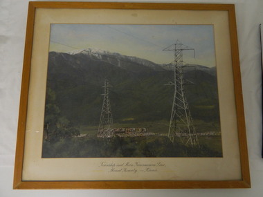
Framed photo - Mt Beauty Township & Main Transmission Line, 1954
... Electricity Commission of Victoria during the construction of the Kiewa Hydro Electric Scheme. This photo belonged to Mr & Mrs Gordon White SECV employee and long time residents of Mt Beauty. Mt Beauty; Transmission line; Tawonga Gap Road; Kiewa Hydro Electric Scheme Approx 1954 / Conroy-Moffatt Pty Ltd / Picture Framer / ..McKillop Street / Tel Mu .. 78 .... This is a framed coloured photo of the Mount Beauty Township and main Transmission Line from Mt Beauty to Kiewa. The photo has two transmission lines ...This is a photo of Mount Beauty taken from a high vantage point near the hair-pin bend on the Tawonga Gap Road (half way up) in 1954. Mount Beauty was built by the State Electricity Commission of Victoria during the construction of the Kiewa Hydro Electric Scheme.This photo belonged to Mr & Mrs Gordon White SECV employee and long time residents of Mt Beauty.This is a framed coloured photo of the Mount Beauty Township and main Transmission Line from Mt Beauty to Kiewa. The photo has two transmission lines in the foreground with the Mt Beauty township in the background, but at the foot of Mount Bogong.Approx 1954 / Conroy-Moffatt Pty Ltd / Picture Framer / ..McKillop Street / Tel Mu .. 78 ....mt beauty; transmission line; tawonga gap road; kiewa hydro electric scheme -
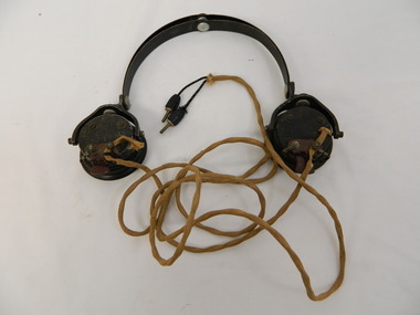
 Kiewa Valley Historical Society
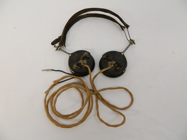
Headphones - Transmitter radio, c1924
... Electricity Commission of Victoria at Bogong during the construction of the Kiewa Hydro Electric Scheme to connect with head office in Melbourne. It allows one conversation at a time using traffic controls in an unusual system of radio telephone providing communication. At the time it was unique in Australia and installed by the S.E.C.V. technicians. It provided an unattended shortwave radio link between two ordinary telephone switchboards, connecting any of the S.E.C.V.'s internal lines...Electricity Commission of Victoria at Bogong during the construction of the Kiewa Hydro Electric Scheme to connect with head office in Melbourne. It allows one conversation at a time using traffic controls in an unusual system of radio telephone providing communication. At the time it was unique in Australia and installed by the S.E.C.V. technicians. It provided an unattended shortwave radio link between two ordinary telephone switchboards, connecting any of the S.E.C.V.'s internal lines ...Radio Telephone was minuted during the war. It was approved in 1944 for State Electricity Commission of Victoria use only. It was completed by the end of 1946. Used by the State Electricity Commission of Victoria at Bogong during the construction of the Kiewa Hydro Electric Scheme to connect with head office in Melbourne. It allows one conversation at a time using traffic controls in an unusual system of radio telephone providing communication. At the time it was unique in Australia and installed by the S.E.C.V. technicians. It provided an unattended shortwave radio link between two ordinary telephone switchboards, connecting any of the S.E.C.V.'s internal lines with the telephone system at Bogong and the construction camps beyond. From Bogong, radio phones connect to the outpost stations on the High Plains far above the snow-line. In operation, the service is similar to a normal telephone system but dispenses with the physical connection of wires and poles between the main terminals. Historical: This type of headphone was recommended for amateurs. It may have been used by operators on the Switchboard at Bogong or one of the construction camps on the Kiewa Hydro Electric Scheme. The S.E.C.V installed this unique system of communication to operate their branches especially at Bogong and beyond where the distance was great and often limited by the terrain and weather.Used for a transmitter radio or Radio Telephone as installed by the State Electricity Commission of Victoria 2 round ear pieces. Outside of ear piece has the brand inscribed and 3 points where wires are attached. On opposite edges of the earpieces a metal piece with handle is attached from which the 2 earpieces are connected with curved wire covered by leather to fit on top of the head. Each earpiece has a cord hanging from the middle attachment (on the outside) which joins and then continues as one to 2 metal pins that would fit into holes in the switchboard. On outside of each earpiece - 'Brunet & Co. / Paris' in oval 'Type f' underneathradio telephone. ear phones. head phones.communications.state electricity commission of victoria. kiewa hydro electric scheme. bogong. switchboards. -
 Kiewa Valley Historical Society
Headphone - Transmitter radio
... Electricity Commission of Victoria at Bogong during the construction of the Kiewa Hydro Electric Scheme to connect with head office in Melbourne. It allows one conversation at a time using traffic controls in an unusual system of radio telephone providing communication. At the time it was unique in Australia and installed by the S.E.C.V. technicians. It provided an unattended shortwave radio link between two ordinary telephone switchboards, connecting any of the S.E.C.V.'s internal lines...Electricity Commission of Victoria at Bogong during the construction of the Kiewa Hydro Electric Scheme to connect with head office in Melbourne. It allows one conversation at a time using traffic controls in an unusual system of radio telephone providing communication. At the time it was unique in Australia and installed by the S.E.C.V. technicians. It provided an unattended shortwave radio link between two ordinary telephone switchboards, connecting any of the S.E.C.V.'s internal lines ...Radio Telephone: Minuted during the war. It was approved in 1944 for State Electricity Commission of Victoria use only. It was completed by the end of 1946. Used by the State Electricity Commission of Victoria at Bogong during the construction of the Kiewa Hydro Electric Scheme to connect with head office in Melbourne. It allows one conversation at a time using traffic controls in an unusual system of radio telephone providing communication. At the time it was unique in Australia and installed by the S.E.C.V. technicians. It provided an unattended shortwave radio link between two ordinary telephone switchboards, connecting any of the S.E.C.V.'s internal lines with the telephone system at Bogong and the construction camps beyond. From Bogong, radio phones connect to the outpost stations on the High Plains far above the snow-line. In operation, the service is similar to a normal telephone system but dispenses with the physical connection of wires and poles between the main terminals.Historical: This type of headphone was used by operators on the switchboards at Bogong, Mt Beauty or on one of the construction camps on the Kiewa Hydro Electric Scheme. The S.E.C.V. installed this unique system of communication to operate their branches especially at Bogong and beyond where the distance was great and often limited by the weather and terrain.Used for a transmitter radio or Radio Telephone as installed by the State Electricity Commission of Victoria 2 round ear pieces. Outside of each ear piece has the brand inscribed, 4 screws and 1 small piece of metal. The metal has 2 screws attaching the the cord that goes to the 'switchboard'. On opposite edges of the earpieces is a thick metal piece that curves up to which the curved metal headpiece is attached and therefore connecting the earpieces. Each earpiece has a cord hanging from the small metal piece of earphone. This cord joins and then continues as one to the end where there are 2 metal pins coming out of the soft cover.'C-LR ST & C of Sydney'radio telephone. ear phones. headphones. communications. state electricity commission of victoria. kiewa hydro electric scheme. bogong. switchboards. -
 Kiewa Valley Historical Society
Headphone Set x2
... Electricity Commission of Victoria at Bogong during the construction of the Kiewa Hydro Electric Scheme to connect with head office in Melbourne. It allows one conversation at a time using traffic controls in an unusual system of radio telephone providing communication. At the time it was unique in Australia and installed by the S.E.C.V. technicians. It provided unattended shortwave radio link between two ordinary telephone switchboards, connecting any of the S.E.C.V.'s internal lines...Electricity Commission of Victoria at Bogong during the construction of the Kiewa Hydro Electric Scheme to connect with head office in Melbourne. It allows one conversation at a time using traffic controls in an unusual system of radio telephone providing communication. At the time it was unique in Australia and installed by the S.E.C.V. technicians. It provided unattended shortwave radio link between two ordinary telephone switchboards, connecting any of the S.E.C.V.'s internal lines ...Radio Telephone was minuted during the war. it was approved in 1944 for the State Electricity Commission of Victoria's use only. it was completed by the end of 1946. used by the State Electricity Commission of Victoria at Bogong during the construction of the Kiewa Hydro Electric Scheme to connect with head office in Melbourne. It allows one conversation at a time using traffic controls in an unusual system of radio telephone providing communication. At the time it was unique in Australia and installed by the S.E.C.V. technicians. It provided unattended shortwave radio link between two ordinary telephone switchboards, connecting any of the S.E.C.V.'s internal lines with the telephone system at Bogong and the construction camps beyond. From Bogong, radio phones connected to the outpost stations on the High Plains far above the snow-line. In operation, the service was similar to a normal telephone system but dispensed with the physical connection of wires and poles between the main terminals.Historical: This headphone set superseded headphones with two earpieces and those without a microphone. This one may have been used by operators on the switchboard at Bogong or Mt Beauty or one of the construction camps on the Kiewa Hydro Electric Scheme. The S.E.C.V. installed this unique system of communication to operate their branches especially at Bogong and beyond where the distance was great and often limited by the terrain and weather.Radio Telephone for SECV switchboard. Black plastic earpiece with microphone. Ear side circular with inscription on outer side then formed into elongated shape narrowing to the curved speaker piece at the narrow end. On top of the narrow end a long rubber cord is attached to a thick brass pin. On top of the wider end a thin stiff wire is attached to curve around the head to a blank rubber earpiece. This head piece has a piece of rectangular rubber attached at the top for comfort.'4408A IW61 / 1'radio telephone, ear phones, head phones. head set. communications, state electricity commission of victoria. kiewa hydro electric scheme. bogong. switchboards -
 Kiewa Valley Historical Society
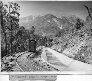
Photo - Bogong Creek Race Line
... lines to catch the water and feed it into the dams that they built to create hydro electric power. The rail line was used to construct the race line and enables the race line to be easily checked for maintenance eg. fallen trees The SECV constructed the Kiewa Hydro Electric Scheme from the late 1940s to 1961 being one of the first hydro schemes and hence environmently friendly. Bogong Creek Race Line Kiewa Hydro Electric Scheme ;Bogong Creek Race Line in pen and attafhed to the photo. On the back "Property of / State Electricity ...The SECV constructed the Kiewa Hydro Electric Scheme which included race lines to catch the water and feed it into the dams that they built to create hydro electric power. The rail line was used to construct the race line and enables the race line to be easily checked for maintenance eg. fallen trees The SECV constructed the Kiewa Hydro Electric Scheme from the late 1940s to 1961 being one of the first hydro schemes and hence environmently friendly.Shiny black and white photo showing the railway track, with a locomotive on it, beside the race line. Snow is on the surrounding mountains. ;Bogong Creek Race Line in pen and attafhed to the photo. On the back "Property of / State Electricity Commission of Victoria/ Publicity photo / Permission to Publish must be obtained / and acknowledgement made. / Negative No. 14-138bogong creek race line, kiewa hydro electric scheme -
 Kiewa Valley Historical Society
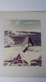
Photo - Rocky Valley Dam
... The State Electricity Commission of Victoria constructed the Kiewa Hydro Electric Scheme on the Bogong High Plains. The scheme consisted of storage dams and pondages, aqueducts, tunnels, pipelines, transmission lines and three power stations.. ...Kiewa Valley Historical Society Mount Beauty Information Centre 31 Bogong High Plains Rd Mt Beauty high-country The State Electricity Commission of Victoria constructed the Kiewa Hydro Electric Scheme on the Bogong High Plains. The scheme consisted of storage dams and pondages, aqueducts, tunnels, pipelines, transmission lines and three power stations.. ...The State Electricity Commission of Victoria constructed the Kiewa Hydro Electric Scheme on the Bogong High Plains. The scheme consisted of storage dams and pondages, aqueducts, tunnels, pipelines, transmission lines and three power stations.. Rocky Valley dam was the biggest storage and the last to be completed.Rocky Valley dam was the largest storage within the Kiewa Hydro Electric Scheme. Begun in 1954 and completed in 1960. It was linked to McKay Creek Power StationColoured photo attached to cream cardboard. The background shows hills and the foreground a sign "Rocky Valley Dam ..." The middle shows the dam with water and its bank. There is snow on the ground.rocky valley dam, kiewa hydro electric scheme, secv -
 Kiewa Valley Historical Society
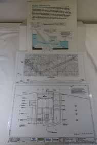
Plans - 2 Southern Hydro - Bogong Power Development and 1 Poster - Hydro-Electricity
... Waterway Plan & Longsection / with Boreholes & Seismic Lines (Also see KVHS 1438) 3. Title: Hydro-Electricity in blue at the top and half-way down a blue and brown diagram titled 'Hydro-Electric Power Station'. ...Waterway Plan & Longsection / with Boreholes & Seismic Lines (Also see KVHS 1438) 3. Title: Hydro-Electricity in blue at the top and half-way down a blue and brown diagram titled 'Hydro-Electric Power Station'. ...Southern Hydro owned the Kiewa Hydro Electric Scheme in 2006. Southern Hydro owned the Kiewa Hydro Electric Scheme in 2006.Laminated A3 sheets The two Southern Hydro Bogong Power Development are black and white. 1. Tunnel and Civil Works / Power Station / Cross Section Sheet 4 of 6 Dated: June 2006 (Also see KVHS 1438) 2. Bogong Power / Development Waterway. Waterway Plan & Longsection / with Boreholes & Seismic Lines (Also see KVHS 1438) 3. Title: Hydro-Electricity in blue at the top and half-way down a blue and brown diagram titled 'Hydro-Electric Power Station'. At the bottom the title 'What is a watt?' southern hydro 2006, bogong power development -
 Kiewa Valley Historical Society
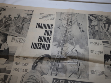
Newspaper - Linesman - S.E.C News 1966, Training our Future Linesmen
... The SEC constructed the Kiewa Hydro Electric Scheme and were resposible for the erection of the power towers and lines enabling the electricity to be distributed throughout the state of Victoria and beyond. linesmen power towers Electric power lines SEC training Pages 6 and 7, S.E.C. ...Linesmen worked on the SEC power towers erecting the towers and supplying lines. They were also responsible for the maintenance of the lines. The article has photos of the men undergoing training with an emphasis on safety.The SEC constructed the Kiewa Hydro Electric Scheme and were resposible for the erection of the power towers and lines enabling the electricity to be distributed throughout the state of Victoria and beyond.Pages 6 and 7, S.E.C. News, April 28, 1966 Article 'Safe Working Paramount' with 9 photos including names of the men working.linesmen, power towers, electric power lines, sec training -
 Kiewa Valley Historical Society
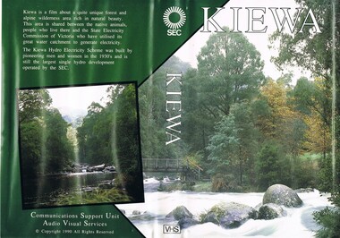
VHS Tape - Kiewa Hydro Electricity Scheme x2, Kiewa, Circa 1990
... The additional resources provided by the State Electricity Commission of Victoria of "alpine bush" fire control and management, together with an ongoing educational scheme for school children in learning about what constitutes the Alpine country's unique environment, are a very important offshoot, benefitting to both the communities within the Kiewa Valley and regional Victoria. secv kiewa valley dale-bromley cy-duff chris- harding michael-glucz forestation education wilderness photography nature film. Front cover "KIEWA" on the spine top circle with lines ...This VHS was produced by the State Electricity Commission of Victoria, to show the pristine state of the Kiewa River and Valley post the completion of the Kiewa Hydro Electricity Scheme (Circa 1950s), The late 1970s on wards was the beginning of deeper social scrutineering by pro environmental groups such as the Australian Wilderness Society (1976) and the Greens (political Party), before, during and after the construction phases of any man made structures in forest/bush areas which may or could damage or adversely affect the natural flora and fauna of sites. This promotional VHS, which was produced in the 1990s, was to project that unlike the Tasmanian State Electricity Commission (Franklin Dam issue), the Victorian State Electricity Commission acted in a way to protect the environment to the maximum level possible. With the passage of time since, and the issue of the global push to minimise carbon pollution, and as an alternative to coal fired power stations, the use of hydro electricity can now be seen as a highly efficient alternative to "coal powered" electricity. This VHS is a snap shot in time (1990) when the Kiewa Valley was still relatively under populated and holiday houses owned by city bound workers was still relatively insignificant. As more and more holiday makers retire to a small but friendly region(Kiewa Valley and Mount Beauty) the increase in visitor numbers will affect the local rural bush scene more and more. The changes that will occur (in time) can be measured against the scenes presented in this video. The additional resources provided by the State Electricity Commission of Victoria of "alpine bush" fire control and management, together with an ongoing educational scheme for school children in learning about what constitutes the Alpine country's unique environment, are a very important offshoot, benefitting to both the communities within the Kiewa Valley and regional Victoria.This VHS tape is stored within its own plastic cover which has a front side covered by a coloured photograph(both front and back cover) of the Kiewa River, just to the north east of the Mount Beauty township. The VHS tape is nestled within a formed inner structure which not only prevents the tape from moving to and fro but also unnecessary intrusion of foreign particles.Front cover "KIEWA" on the spine top circle with lines projecting out and below this "SEC". Middle of spine "KIEWA" and bottom of spine "VHS"secv, kiewa valley, dale-bromley, cy-duff, chris- harding, michael-glucz, forestation education, wilderness photography, nature film. -
 Kiewa Valley Historical Society
Bowl Ceramic, circa mid to late 1900's
... Electricity Scheme circa 1950's. Due to the uneven pattern it can be assumed that this bowl was a cheap imported one possibly from Asia. This bowl has historical significance as a cheap imported mixing bowl or soup/main meal dish that shows the influence of the migrant infusion into the Kiewa Valley, maybe in the "gold rush" era. kitchen bowl main rice dish mixing bowl bottom inscription too faded to read This medium sized ceramic/porcelain bowl has a gold painted rim and fine blue hair pin patterns and flowers. The pattern has been poorly applied and the irregular top lines ...This bowl was probably used by migrant workers on the SEC Victoria Kiewa Hydro Electricity Scheme circa 1950's. Due to the uneven pattern it can be assumed that this bowl was a cheap imported one possibly from Asia.This bowl has historical significance as a cheap imported mixing bowl or soup/main meal dish that shows the influence of the migrant infusion into the Kiewa Valley, maybe in the "gold rush" era. This medium sized ceramic/porcelain bowl has a gold painted rim and fine blue hair pin patterns and flowers. The pattern has been poorly applied and the irregular top lines appear to indicate an unprofessional alignment. The exterior has a rippled formation which has not been extended to the top rim. bottom inscription too faded to readkitchen bowl, main rice dish, mixing bowl -
 Kiewa Valley Historical Society
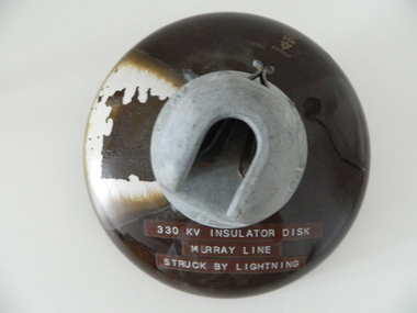
Insulator Disk High Voltage, 1964
... The need for a mountainous and a large area of operational requirements, such as the SEC Vic Kiewa Hydro Electricity Scheme, to distribute the electricity produced in the Victorian Alps to the major users required power transmission lines to "carry" high above the sometimes inaccessible land mass electricity generated at the power stations to the various sub stations along the valleys and ranges to flatter populated regions. ...This insulator disk for the high voltage carrying electrical cables was manufactured in 1964 and used by the SEC Vic (Kiewa Hydro Electricity Scheme) from that date until late 1900's. It was used to connect high voltage cables to their "towers" going from various Hydro Generators to and from power "stations". During this time period, high quality "cable" insulators were manufactured in Japan. In an earlier time they would have been sourced from Europe or England. After the 1950's the sourcing of electrical hardware was being influenced by the lower costs obtainable from Japan. Later on other Asian sources also became available.The need for a mountainous and a large area of operational requirements, such as the SEC Vic Kiewa Hydro Electricity Scheme, to distribute the electricity produced in the Victorian Alps to the major users required power transmission lines to "carry" high above the sometimes inaccessible land mass electricity generated at the power stations to the various sub stations along the valleys and ranges to flatter populated regions. The significance of this insulation "high voltage" disk to the Kiewa Valley region relates to the impact of modern technology (at that time) upon a mainly rural environment. These power lines are a stark visual "show" of the impact that the "Scheme" has on the mostly rural landscape of the Kiewa Valley and what a boost of "modern" equipment into the area has taken place. The "Hydro Scheme" had facilitated the transition of a semi rural area to an advanced rural region within a shorter time frame, than would have taken under "normal" evolutionary time. The speed of information of all "new technology" had a relatively slow assimilation rate before the SEC Kiewa Hydro Scheme came to those living in the then quieter rural communities. This high voltage (330 KV) insulation disk is made from non conductive porcelain stoneware. It is highly polished brown in colour and has a clip fastening for the high voltage cable to be attached to. This disk was hit by lightning and the burn marks are quite noticeable. The top metal connector has a "mushroom" extension jutting below the semi cone like insulation disk. Also four circular ridges or grooves (old 78 rpm disc recording style).Cable bell on top of insulation disk "4K " next to it the international symbol for electricity (triangle containing one horizontal line under one V line and one vertical flame like line.) On the opposite side "2" and to the right "64"sec vic kiewa hydro scheme, alternate energy supplies, alpine (above ground) high voltage electricity cables, volt cable, 330000 volt cable -
 Federation University Historical Collection
Flyer, With Compliments of R.H. Sutton & Co Ballarat
... Henry Sutton taught Applied Electricity at the Ballarat School of Mines in 1883 to 1886. pianos and organs mason and hamlin four great lines lindahl piano band instruments orpheus boosey's with compliments r.h sutton and co. ballarat Henry Sutton With compliments card from R.H Sutton Music house Ballarat, metalic background with brass band member playing a cornet With Compliments of R.H. ...Henry Sutton is a talented world-wide accepted inventor with inventions relating to the telephone, photography, wireless, cars, motorcycles, and bicycles as well as many more inventions. Henry was also one of four brothers that ran the Sutton's Music Store after the death of their Father Richard Sutton. Henry Sutton taught Applied Electricity at the Ballarat School of Mines in 1883 to 1886.With compliments card from R.H Sutton Music house Ballarat, metalic background with brass band member playing a cornetpianos and organs, mason and hamlin, four great lines, lindahl piano, band instruments, orpheus, boosey's, with compliments, r.h sutton and co. ballarat, henry sutton -
 Orbost & District Historical Society
candlestick, late 19th century
... Before the advent of electricity candlesticks were a necessity in every household. candlestick brass Victorian lighting domestic-lighting candle A tall and thin brass candlestick on a hexagonal base.The candlestick has a decorative shape with several raised bands and engraved lines encircling the body horizontally. ...Brass is an alloy made of two-thirds copper and one-third zinc, although the ratio varies.Before the advent of electricity candlesticks were a necessity in every household.A tall and thin brass candlestick on a hexagonal base.The candlestick has a decorative shape with several raised bands and engraved lines encircling the body horizontally. It has two concentric circles decorating the foot. candlestick brass victorian lighting domestic-lighting candle -
 Eltham District Historical Society Inc
Photograph - Aerial Photograph, Landata, Eltham; Crown Allotment 15, Section 5, Parish of Nillumbik (Stokes Orchard Estate), Dec. 1945
... electricity easement. CA15 as it exists today has a complicated history of rural use, Government acquisition, urban development, and community action. References: • “Stokes Orchard, an incomplete history”; Russell Yeoman with Doug Orford • Correspondence, Beryl Bradbury (nee Stokes) • Aerial Photographs, 1931-1991, Landata (landata.vic.gov.au) • Certificate of Title, Vol. 4930 Fol. 985900 • Plan Number LP 10859 Aerial Photo Diosma Road Eltham Copper Butterfly Eucalyptus Road Ironbark Close Nyora Road Peppermint Grove Peter & Elizabeth Pidgeon Collection Power transmission lines Reynolds Road Scarlet Ash Court Stokes Orchard Estate Stokes Place Woodridge Estate Frank Stokes Digital jpg and electronic PDF file Eltham; Crown Allotment 15, Section 5, Parish of Nillumbik (Stokes Orchard Estate) Photograph Aerial Photograph Landata ...Centred on present day Diosma Rd, Stokes Pl, Nyora Rd and Eucalyptus Rd Historic Aerial Imagery Source: Landata.vic.gov.au Aerial Photo Details: Project No :5 Project : MELBOURNE AND METROPOLITAN AREA PROJECT Run : 36 Frame : 60546 Date : 12/1945 Film Type : B/W Camera : EAG4 Flying Height : 10200 Scale : 6000 Film Number : 195 GDA2020 : 37°42'47"S, 145°09'56"E MGA2020 : 338306, 5824438 (55) Melways : 22 C4 (ed. 42) A History of the Development of Crown Allotment 15, Section 5, Parish of Nillumbik – Stokes Orchard Crown Allotment 15, Section 5, Parish of Nillumbik (CA15) is a square allotment of 158 acres or approximately a quarter of a square mile. It lies just beyond the eastern end of Pitt Street, south of Nyora Road to the northern end of Eucalyptus Road and extends east from Eucalyptus Road to Reynolds Road. The topography of CA15 is generally steep, sloping up to a hill near the centre of the land, the ridgeline passing through the properties along the southern side of Diosma Road. Eucalyptus Road is a straight north-south road with its northern end at the north west corner of CA15. Until the end of the 1970s this road was an un-named Government Road and was largely not open to traffic. With residential development in the 1970s the road was constructed, and the council allocated the name obviously in recognition of the predominant species of the local bushland. CA15 was purchased from the Crown by George D’Arley Boursiquot, a prominent Melbourne printer, on 28th October 1852. On November 23, 1922, former Member for Gippsland and Melbourne Real Estate Agent, Hubert Patrick Keogh purchased the allotment then sold it March 13, 1925, to local farmer, Robert David Taylor, a former Shire of Eltham Councillor (1911-1920) and Shire President (1919). Taylor had extensive land holdings stretching west towards Bible Street and Main Road. The Taylor home was situated at the top of the hill in Bible Street at present day 82 Bible Street. At the time of Taylor’s purchase in 1925, CA15 was subdivided into 48 lots that could be described as small rural properties or large residential lots. A typical lot size was one hectare or 2.5 acres. The subdivision created two roads, Nyora Road, and Diosma Road, each following an irregular alignment between Eucalyptus and Reynolds Roads. However, the lots were not sold off separately nor were the roads constructed. The land effectively remained as one parcel for many further years. Robert David Taylor died November 30, 1934, and probate was granted to his son of the same name, Robert David Taylor of Bible Street, Salesman and William McLelland Vance Taylor of 73 Emmeline Street, Northcote, Clerk, with the transfer of the land into their names on July 8, 1935. Frank Stokes worked as a qualified accountant at Kennons leather factory in Burnley, while living at 1 Thomas Street, Mitcham. He suffered from migraines and wanted to return to working the land (he had previously worked on farms and orchards since coming to Australia from England in 1926, both in WA and Vic.). He first travelled to the district by train in July 1942 to find land with the intention to establish an orchard. By chance he met Arthur Bird of Bird Orchard (bounded by Pitt Street, Eucalyptus Road, and Wattle Grove) and they got talking over their common interest. Arthur put Frank up for the night and pointed out the land, 158 acres- part of the Taylor Estate- £900, Crown Allotment 15, Section 5, Parish of Nillumbik (CA15) somewhat diagonally opposite Bird Orchard. Stokes applied through the Riverina Agency to purchase the land who in turn applied for permission from Canberra to sell as there was a new government regulation introduced during the Second World War banning land sales except for immediate production. Stokes obtained a loan on his Mitcham house of £600 @ 5% and paid £450 deposit with quarterly payments of £15 spread over 5 years. Stokes was assisted and advised by Arthur Bird who farmed the neighbouring orchard. In early 1943 Stokes took possession and would catch the train out to Eltham on Fridays after work and began building a hut on the corner of Nyora Road and the Government Road (Eucalyptus Road) for shelter and to lock up tools. He established an orchard on the central western part of the land through the centre of which ran a natural waterway (part of the present-day linear park) and was able to pay a neighbour (Hawkins) to help with clearing and fencing 25 acres, and with a horse and single furrowed plough, planted approximately 2,500 fruit trees - cherries, peaches, plums, almonds, pears, apricots and lemons as well as a few apples and oranges; a massive task. Aerial photographs from the 1940s through to the 1990s clearly show the orchard with most of the larger CA15 site remaining as natural bushland. A huge problem was hares and rabbits eating all the new buds off the tiny trees. As well as laying poison he painted the trees with a mixture of cow manure and lime, often working by moonlight. Procurement of wire and wire netting was difficult because of the war but after much effort he obtained a permit from the Agricultural Department for supplies in March 1944. In February 1945 Stokes applied for a permit to build a “packing shed” as no house building was allowed. It was to be 33 feet x 21 feet and cost £312. It was constructed mostly from second-hand materials, which were hard to obtain, especially iron for roofing. Stokes finished work at Kennons on October 31, 1945, and in March 1946 he sold the family home at Mitcham for £1,230 plus £170 for furniture. On May 15, 1946, title to the CA15 property was issued to Frank Howard Alfred Stokes, Orchardist and Gladys Ethel Stokes, Married Woman, both of Pitt Street, Eltham. The family of five then moved into the very unfinished “packing shed” at Eltham, which was a struggle to weatherproof. Eventually rooms were divided off and lined with hessian bags and whitewashed. Their income was firewood (cut and sold), selling rockery stones and cut Sweet Bursaria. (It was discovered during the 1940s that Sweet Bursaria contained the sunscreen compound Aesculin. The RAAF utilised this compound from Sweet Bursaria during WW2 for pilots and gunners.) The orchard’s first fruit sale was a half-case of Le Vanq peaches in December 1947 for the price of 8 shillings. In 1956 plans for house were drawn and Glen Iris bricks purchased (1956 Olympic Rings variant). The building of the house commenced in 1957 - 12 feet of original packing shed was removed – and was completed in 1959. Water was connected from newly built pressure storage on the property at the end of 1959 and the electricity connection for the first time at 3pm on April 29, 1960. The house remains to present day (somewhat modified) at 1 Nyora Road, home to Nyora Studio Gallery. On occasions, spare remnants of the 1956 bricks have been known to be unearthed in gardens on the estate as they were utilised by Frank Stokes to fill in rabbit holes. On May 26, 1950, a parcel of land was compulsorily acquired by the Melbourne and Metropolitan Board of Works on the hilltop to establish an easement for a high-level service reservoir to augment Eltham’s water supply. The project also included pipe tracks for the necessary water mains. The reservoir has now been superseded by higher level water tanks east of Reynolds Road and its former site is now a public reserve. On November 27, 1964, the State Electricity Commission served notice to compulsorily acquire a further parcel through the eastern part of the land for a major electricity transmission line that augmented supply from the La Trobe Valley to Melbourne. The easement was registered February 11, 1966. The easement was widened July 18, 1969 for a second transmission line to be constructed. In 1971 Melbourne Metropolitan Planning Scheme amendments adopted Nyora Road as the boundary between a residential zone to the north and a rural zone to the south. This determined the future development of the land. In the mid-1970s the Shire of Eltham divided the orchard into numerous rate-able parcel lots, the 48 lots having been established in 1925 and the subsequent rates assessment proved unsustainable for Stokes. He commenced selling lots outside the boundary of the orchard, north of Diosma and South of Nyora. However shortly later the land between Nyora and Diosma Roads and west of the electricity easement was sold and subdivided into residential lots, a housing development by Macquarie Builders and marketed as the Stokes Orchard Estate. New streets were created, and most were named after trees, although one, Stokes Place, commemorates the former owners. The development was undertaken in two stages; Stage 1 (1975) encompassing Scarlet Ash Court, Ironbark Close and Peppermint Grove bounded by Nyora and Eucalyptus roads and Stage 2 (1978) encompassing Stokes Place, Orchard Way, The Crest and The Lookout bound by Nyora and Diosma roads. The developer, Macquarie Builders went bankrupt shortly after the release of Stage 2 leaving many purchasers to fend for themselves and arrange for their own independent builders. There were also difficulties with sewerage for the land immediately south of Diosma Road and so the conventional residential lots were abandoned in favour of larger lots. The development of Orchard Way, The Crest and The Lookout did not proceed as planned and the proposed lots were incorporated into five-acre parcels instead. These included a low-density group housing development by the Graves family and the award winning Choong House (1983) with Gordon Ford developed garden immediately next door situated on the ridge of the hill nestled amongst the original bush, Eucalypt trees and Sweet Bursaria. In 1994, Nillumbik Shire Council applied Significant Environment and Significant Landscape overlays upon the properties on the south side of Diosma Road to ensure protection of this natural bush garden environment. With the arrival of the sewer along Diosma Road in the 1990s, most of these five-acre parcels have since been subdivided multiple times. The Choong house presently sits on a 2.7-acre property, which in 2022 Nillumbik Council nominated for Cultural Significance Heritage protection and is considered potentially significant at State level. The Stokes family were also associated with the Eltham Christian Church. In the 1970s this church had met in temporary premises in Eltham. Lots of the original 1925 subdivision remained south of Nyora Road and a number of these lots were utilized for the Eltham Christian School, which was established by the Eltham Christian Church in 1981. The school operated on this site until 2000. The premises are now used by The Vine Baptist Church. By the mid-1980s the whole of CA15 had been developed for residential and school purposes, except for the sections north of Diosma Road and between the transmission lines and Reynolds Road. Sewerage issues had been resolved for the section north of Diosma Road and in 1987 it was in the process of being subdivided into residential lots. The development coincided with the discovery of colonies of the rare and endangered Eltham Copper Butterfly on the site. This resulted in a community and political campaign to save the butterfly habitat. With the co-operation of the land developer the subdivision was altered to create two bushland reserves in the critical butterfly habitat areas. In the late 1980s the State Government was investigating options for establishing a metropolitan ring road link between Diamond Creek and Ringwood. The chosen route was adjacent to Reynolds Road and so this created a freeze on development of CA15 between Reynolds Road and the electricity easement. The ring road proposal was eventually abandoned, and this part of the land was subdivided into low density residential lots. Diosma Road has been discontinued at the electricity easement and the eastern part incorporated into View Mount Court with access from Reynolds Road. The whole of CA15 has now been developed for residential or associated purposes, ranging from conventional density to quite low density south of Nyora Road. Some remnants of the orchard remain, a few cherry trees on the Graves property and a lone apple tree in Stokes Place. The butterfly reserves comprise significant areas of remnant bushland. Linear reserves through the estate link with central Eltham via the Woodridge linear reserve and with Research along the electricity easement. CA15 as it exists today has a complicated history of rural use, Government acquisition, urban development, and community action. References: • “Stokes Orchard, an incomplete history”; Russell Yeoman with Doug Orford • Correspondence, Beryl Bradbury (nee Stokes) • Aerial Photographs, 1931-1991, Landata (landata.vic.gov.au) • Certificate of Title, Vol. 4930 Fol. 985900 • Plan Number LP 10859 aerial photo, diosma road, eltham copper butterfly, eucalyptus road, ironbark close, nyora road, peppermint grove, peter & elizabeth pidgeon collection, power transmission lines, reynolds road, scarlet ash court, stokes orchard estate, stokes place, woodridge estate, frank stokes -
 Eltham District Historical Society Inc
Photograph - Aerial Photograph, Landata, Eltham; Crown Allotment 15, Section 5, Parish of Nillumbik (Stokes Orchard Estate), Nov. 1931
... electricity easement. CA15 as it exists today has a complicated history of rural use, Government acquisition, urban development, and community action. References: • “Stokes Orchard, an incomplete history”; Russell Yeoman with Doug Orford • Correspondence, Beryl Bradbury (nee Stokes) • Aerial Photographs, 1931-1991, Landata (landata.vic.gov.au) • Certificate of Title, Vol. 4930 Fol. 985900 • Plan Number LP 10859 Aerial Photo Diosma Road Eltham Copper Butterfly Eucalyptus Road Ironbark Close Nyora Road Peppermint Grove Peter & Elizabeth Pidgeon Collection Power transmission lines Reynolds Road Scarlet Ash Court Stokes Orchard Estate Stokes Place Woodridge Estate Frank Stokes Digital jpg and electronic PDF file Eltham; Crown Allotment 15, Section 5, Parish of Nillumbik (Stokes Orchard Estate) Photograph Aerial Photograph Landata ...Centred over present day Reynolds Road and Mount Pleasant Road, Eltham (including Diosma Rd, Stokes Pl, Nyora Rd and Eucalyptus Rd) Historic Aerial Imagery Source: Landata.vic.gov.au Aerial Photo Details: Project No :1931 Project : MALDON PRISON Run : 21 Frame : 3160 Date : 11/1931 Film Type : B/W Camera : F8 Flying Height : 11000 Scale : 18860 Film Number : 60 GDA2020 : 37°43'31"S, 145°10'20"E MGA2020 : 338912, 5823086 (55) Melways : 22 E8 (ed. 42) A History of the Development of Crown Allotment 15, Section 5, Parish of Nillumbik – Stokes Orchard Crown Allotment 15, Section 5, Parish of Nillumbik (CA15) is a square allotment of 158 acres or approximately a quarter of a square mile. It lies just beyond the eastern end of Pitt Street, south of Nyora Road to the northern end of Eucalyptus Road and extends east from Eucalyptus Road to Reynolds Road. The topography of CA15 is generally steep, sloping up to a hill near the centre of the land, the ridgeline passing through the properties along the southern side of Diosma Road. Eucalyptus Road is a straight north-south road with its northern end at the north west corner of CA15. Until the end of the 1970s this road was an un-named Government Road and was largely not open to traffic. With residential development in the 1970s the road was constructed, and the council allocated the name obviously in recognition of the predominant species of the local bushland. CA15 was purchased from the Crown by George D’Arley Boursiquot, a prominent Melbourne printer, on 28th October 1852. On November 23, 1922, former Member for Gippsland and Melbourne Real Estate Agent, Hubert Patrick Keogh purchased the allotment then sold it March 13, 1925, to local farmer, Robert David Taylor, a former Shire of Eltham Councillor (1911-1920) and Shire President (1919). Taylor had extensive land holdings stretching west towards Bible Street and Main Road. The Taylor home was situated at the top of the hill in Bible Street at present day 82 Bible Street. At the time of Taylor’s purchase in 1925, CA15 was subdivided into 48 lots that could be described as small rural properties or large residential lots. A typical lot size was one hectare or 2.5 acres. The subdivision created two roads, Nyora Road, and Diosma Road, each following an irregular alignment between Eucalyptus and Reynolds Roads. However, the lots were not sold off separately nor were the roads constructed. The land effectively remained as one parcel for many further years. Robert David Taylor died November 30, 1934, and probate was granted to his son of the same name, Robert David Taylor of Bible Street, Salesman and William McLelland Vance Taylor of 73 Emmeline Street, Northcote, Clerk, with the transfer of the land into their names on July 8, 1935. Frank Stokes worked as a qualified accountant at Kennons leather factory in Burnley, while living at 1 Thomas Street, Mitcham. He suffered from migraines and wanted to return to working the land (he had previously worked on farms and orchards since coming to Australia from England in 1926, both in WA and Vic.). He first travelled to the district by train in July 1942 to find land with the intention to establish an orchard. By chance he met Arthur Bird of Bird Orchard (bounded by Pitt Street, Eucalyptus Road, and Wattle Grove) and they got talking over their common interest. Arthur put Frank up for the night and pointed out the land, 158 acres- part of the Taylor Estate- £900, Crown Allotment 15, Section 5, Parish of Nillumbik (CA15) somewhat diagonally opposite Bird Orchard. Stokes applied through the Riverina Agency to purchase the land who in turn applied for permission from Canberra to sell as there was a new government regulation introduced during the Second World War banning land sales except for immediate production. Stokes obtained a loan on his Mitcham house of £600 @ 5% and paid £450 deposit with quarterly payments of £15 spread over 5 years. Stokes was assisted and advised by Arthur Bird who farmed the neighbouring orchard. In early 1943 Stokes took possession and would catch the train out to Eltham on Fridays after work and began building a hut on the corner of Nyora Road and the Government Road (Eucalyptus Road) for shelter and to lock up tools. He established an orchard on the central western part of the land through the centre of which ran a natural waterway (part of the present-day linear park) and was able to pay a neighbour (Hawkins) to help with clearing and fencing 25 acres, and with a horse and single furrowed plough, planted approximately 2,500 fruit trees - cherries, peaches, plums, almonds, pears, apricots and lemons as well as a few apples and oranges; a massive task. Aerial photographs from the 1940s through to the 1990s clearly show the orchard with most of the larger CA15 site remaining as natural bushland. A huge problem was hares and rabbits eating all the new buds off the tiny trees. As well as laying poison he painted the trees with a mixture of cow manure and lime, often working by moonlight. Procurement of wire and wire netting was difficult because of the war but after much effort he obtained a permit from the Agricultural Department for supplies in March 1944. In February 1945 Stokes applied for a permit to build a “packing shed” as no house building was allowed. It was to be 33 feet x 21 feet and cost £312. It was constructed mostly from second-hand materials, which were hard to obtain, especially iron for roofing. Stokes finished work at Kennons on October 31, 1945, and in March 1946 he sold the family home at Mitcham for £1,230 plus £170 for furniture. On May 15, 1946, title to the CA15 property was issued to Frank Howard Alfred Stokes, Orchardist and Gladys Ethel Stokes, Married Woman, both of Pitt Street, Eltham. The family of five then moved into the very unfinished “packing shed” at Eltham, which was a struggle to weatherproof. Eventually rooms were divided off and lined with hessian bags and whitewashed. Their income was firewood (cut and sold), selling rockery stones and cut Sweet Bursaria. (It was discovered during the 1940s that Sweet Bursaria contained the sunscreen compound Aesculin. The RAAF utilised this compound from Sweet Bursaria during WW2 for pilots and gunners.) The orchard’s first fruit sale was a half-case of Le Vanq peaches in December 1947 for the price of 8 shillings. In 1956 plans for house were drawn and Glen Iris bricks purchased (1956 Olympic Rings variant). The building of the house commenced in 1957 - 12 feet of original packing shed was removed – and was completed in 1959. Water was connected from newly built pressure storage on the property at the end of 1959 and the electricity connection for the first time at 3pm on April 29, 1960. The house remains to present day (somewhat modified) at 1 Nyora Road, home to Nyora Studio Gallery. On occasions, spare remnants of the 1956 bricks have been known to be unearthed in gardens on the estate as they were utilised by Frank Stokes to fill in rabbit holes. On May 26, 1950, a parcel of land was compulsorily acquired by the Melbourne and Metropolitan Board of Works on the hilltop to establish an easement for a high-level service reservoir to augment Eltham’s water supply. The project also included pipe tracks for the necessary water mains. The reservoir has now been superseded by higher level water tanks east of Reynolds Road and its former site is now a public reserve. On November 27, 1964, the State Electricity Commission served notice to compulsorily acquire a further parcel through the eastern part of the land for a major electricity transmission line that augmented supply from the La Trobe Valley to Melbourne. The easement was registered February 11, 1966. The easement was widened July 18, 1969 for a second transmission line to be constructed. In 1971 Melbourne Metropolitan Planning Scheme amendments adopted Nyora Road as the boundary between a residential zone to the north and a rural zone to the south. This determined the future development of the land. In the mid-1970s the Shire of Eltham divided the orchard into numerous rate-able parcel lots, the 48 lots having been established in 1925 and the subsequent rates assessment proved unsustainable for Stokes. He commenced selling lots outside the boundary of the orchard, north of Diosma and South of Nyora. However shortly later the land between Nyora and Diosma Roads and west of the electricity easement was sold and subdivided into residential lots, a housing development by Macquarie Builders and marketed as the Stokes Orchard Estate. New streets were created, and most were named after trees, although one, Stokes Place, commemorates the former owners. The development was undertaken in two stages; Stage 1 (1975) encompassing Scarlet Ash Court, Ironbark Close and Peppermint Grove bounded by Nyora and Eucalyptus roads and Stage 2 (1978) encompassing Stokes Place, Orchard Way, The Crest and The Lookout bound by Nyora and Diosma roads. The developer, Macquarie Builders went bankrupt shortly after the release of Stage 2 leaving many purchasers to fend for themselves and arrange for their own independent builders. There were also difficulties with sewerage for the land immediately south of Diosma Road and so the conventional residential lots were abandoned in favour of larger lots. The development of Orchard Way, The Crest and The Lookout did not proceed as planned and the proposed lots were incorporated into five-acre parcels instead. These included a low-density group housing development by the Graves family and the award winning Choong House (1983) with Gordon Ford developed garden immediately next door situated on the ridge of the hill nestled amongst the original bush, Eucalypt trees and Sweet Bursaria. In 1994, Nillumbik Shire Council applied Significant Environment and Significant Landscape overlays upon the properties on the south side of Diosma Road to ensure protection of this natural bush garden environment. With the arrival of the sewer along Diosma Road in the 1990s, most of these five-acre parcels have since been subdivided multiple times. The Choong house presently sits on a 2.7-acre property, which in 2022 Nillumbik Council nominated for Cultural Significance Heritage protection and is considered potentially significant at State level. The Stokes family were also associated with the Eltham Christian Church. In the 1970s this church had met in temporary premises in Eltham. Lots of the original 1925 subdivision remained south of Nyora Road and a number of these lots were utilized for the Eltham Christian School, which was established by the Eltham Christian Church in 1981. The school operated on this site until 2000. The premises are now used by The Vine Baptist Church. By the mid-1980s the whole of CA15 had been developed for residential and school purposes, except for the sections north of Diosma Road and between the transmission lines and Reynolds Road. Sewerage issues had been resolved for the section north of Diosma Road and in 1987 it was in the process of being subdivided into residential lots. The development coincided with the discovery of colonies of the rare and endangered Eltham Copper Butterfly on the site. This resulted in a community and political campaign to save the butterfly habitat. With the co-operation of the land developer the subdivision was altered to create two bushland reserves in the critical butterfly habitat areas. In the late 1980s the State Government was investigating options for establishing a metropolitan ring road link between Diamond Creek and Ringwood. The chosen route was adjacent to Reynolds Road and so this created a freeze on development of CA15 between Reynolds Road and the electricity easement. The ring road proposal was eventually abandoned, and this part of the land was subdivided into low density residential lots. Diosma Road has been discontinued at the electricity easement and the eastern part incorporated into View Mount Court with access from Reynolds Road. The whole of CA15 has now been developed for residential or associated purposes, ranging from conventional density to quite low density south of Nyora Road. Some remnants of the orchard remain, a few cherry trees on the Graves property and a lone apple tree in Stokes Place. The butterfly reserves comprise significant areas of remnant bushland. Linear reserves through the estate link with central Eltham via the Woodridge linear reserve and with Research along the electricity easement. CA15 as it exists today has a complicated history of rural use, Government acquisition, urban development, and community action. References: • “Stokes Orchard, an incomplete history”; Russell Yeoman with Doug Orford • Correspondence, Beryl Bradbury (nee Stokes) • Aerial Photographs, 1931-1991, Landata (landata.vic.gov.au) • Certificate of Title, Vol. 4930 Fol. 985900 • Plan Number LP 10859 aerial photo, diosma road, eltham copper butterfly, eucalyptus road, ironbark close, nyora road, peppermint grove, peter & elizabeth pidgeon collection, power transmission lines, reynolds road, scarlet ash court, stokes orchard estate, stokes place, woodridge estate, frank stokes -
 Eltham District Historical Society Inc
Photograph - Aerial Photograph, Landata, Eltham; Crown Allotment 15, Section 5, Parish of Nillumbik (Stokes Orchard Estate), Jan. 1951
... electricity easement. CA15 as it exists today has a complicated history of rural use, Government acquisition, urban development, and community action. References: • “Stokes Orchard, an incomplete history”; Russell Yeoman with Doug Orford • Correspondence, Beryl Bradbury (nee Stokes) • Aerial Photographs, 1931-1991, Landata (landata.vic.gov.au) • Certificate of Title, Vol. 4930 Fol. 985900 • Plan Number LP 10859 Aerial Photo Diosma Road Eltham Copper Butterfly Eucalyptus Road Ironbark Close Nyora Road Peppermint Grove Peter & Elizabeth Pidgeon Collection Power transmission lines Reynolds Road Scarlet Ash Court Stokes Orchard Estate Stokes Place Woodridge Estate Frank Stokes Digital jpg and electronic PDF file Eltham; Crown Allotment 15, Section 5, Parish of Nillumbik (Stokes Orchard Estate) Photograph Aerial Photograph Landata ...Centred on present day Diosma Rd, Stokes Pl, Nyora Rd and Eucalyptus Rd Historic Aerial Imagery Source: Landata.vic.gov.au Aerial Photo Details: Project No :65 Project : MELBOURNE AND METROPOLITAN PROJECT NO. 2 Run : 8 Frame : 71 Date : 01/1951 Film Type : B/W Camera : EAG9 Flying Height : 12200 Scale : 12000 Film Number : 1419 GDA2020 : 37°43'14"S, 145°09'46"E MGA2020 : 338081, 5823608 (55) Melways : 22 C6 (ed. 42) A History of the Development of Crown Allotment 15, Section 5, Parish of Nillumbik – Stokes Orchard Crown Allotment 15, Section 5, Parish of Nillumbik (CA15) is a square allotment of 158 acres or approximately a quarter of a square mile. It lies just beyond the eastern end of Pitt Street, south of Nyora Road to the northern end of Eucalyptus Road and extends east from Eucalyptus Road to Reynolds Road. The topography of CA15 is generally steep, sloping up to a hill near the centre of the land, the ridgeline passing through the properties along the southern side of Diosma Road. Eucalyptus Road is a straight north-south road with its northern end at the north west corner of CA15. Until the end of the 1970s this road was an un-named Government Road and was largely not open to traffic. With residential development in the 1970s the road was constructed, and the council allocated the name obviously in recognition of the predominant species of the local bushland. CA15 was purchased from the Crown by George D’Arley Boursiquot, a prominent Melbourne printer, on 28th October 1852. On November 23, 1922, former Member for Gippsland and Melbourne Real Estate Agent, Hubert Patrick Keogh purchased the allotment then sold it March 13, 1925, to local farmer, Robert David Taylor, a former Shire of Eltham Councillor (1911-1920) and Shire President (1919). Taylor had extensive land holdings stretching west towards Bible Street and Main Road. The Taylor home was situated at the top of the hill in Bible Street at present day 82 Bible Street. At the time of Taylor’s purchase in 1925, CA15 was subdivided into 48 lots that could be described as small rural properties or large residential lots. A typical lot size was one hectare or 2.5 acres. The subdivision created two roads, Nyora Road, and Diosma Road, each following an irregular alignment between Eucalyptus and Reynolds Roads. However, the lots were not sold off separately nor were the roads constructed. The land effectively remained as one parcel for many further years. Robert David Taylor died November 30, 1934, and probate was granted to his son of the same name, Robert David Taylor of Bible Street, Salesman and William McLelland Vance Taylor of 73 Emmeline Street, Northcote, Clerk, with the transfer of the land into their names on July 8, 1935. Frank Stokes worked as a qualified accountant at Kennons leather factory in Burnley, while living at 1 Thomas Street, Mitcham. He suffered from migraines and wanted to return to working the land (he had previously worked on farms and orchards since coming to Australia from England in 1926, both in WA and Vic.). He first travelled to the district by train in July 1942 to find land with the intention to establish an orchard. By chance he met Arthur Bird of Bird Orchard (bounded by Pitt Street, Eucalyptus Road, and Wattle Grove) and they got talking over their common interest. Arthur put Frank up for the night and pointed out the land, 158 acres- part of the Taylor Estate- £900, Crown Allotment 15, Section 5, Parish of Nillumbik (CA15) somewhat diagonally opposite Bird Orchard. Stokes applied through the Riverina Agency to purchase the land who in turn applied for permission from Canberra to sell as there was a new government regulation introduced during the Second World War banning land sales except for immediate production. Stokes obtained a loan on his Mitcham house of £600 @ 5% and paid £450 deposit with quarterly payments of £15 spread over 5 years. Stokes was assisted and advised by Arthur Bird who farmed the neighbouring orchard. In early 1943 Stokes took possession and would catch the train out to Eltham on Fridays after work and began building a hut on the corner of Nyora Road and the Government Road (Eucalyptus Road) for shelter and to lock up tools. He established an orchard on the central western part of the land through the centre of which ran a natural waterway (part of the present-day linear park) and was able to pay a neighbour (Hawkins) to help with clearing and fencing 25 acres, and with a horse and single furrowed plough, planted approximately 2,500 fruit trees - cherries, peaches, plums, almonds, pears, apricots and lemons as well as a few apples and oranges; a massive task. Aerial photographs from the 1940s through to the 1990s clearly show the orchard with most of the larger CA15 site remaining as natural bushland. A huge problem was hares and rabbits eating all the new buds off the tiny trees. As well as laying poison he painted the trees with a mixture of cow manure and lime, often working by moonlight. Procurement of wire and wire netting was difficult because of the war but after much effort he obtained a permit from the Agricultural Department for supplies in March 1944. In February 1945 Stokes applied for a permit to build a “packing shed” as no house building was allowed. It was to be 33 feet x 21 feet and cost £312. It was constructed mostly from second-hand materials, which were hard to obtain, especially iron for roofing. Stokes finished work at Kennons on October 31, 1945, and in March 1946 he sold the family home at Mitcham for £1,230 plus £170 for furniture. On May 15, 1946, title to the CA15 property was issued to Frank Howard Alfred Stokes, Orchardist and Gladys Ethel Stokes, Married Woman, both of Pitt Street, Eltham. The family of five then moved into the very unfinished “packing shed” at Eltham, which was a struggle to weatherproof. Eventually rooms were divided off and lined with hessian bags and whitewashed. Their income was firewood (cut and sold), selling rockery stones and cut Sweet Bursaria. (It was discovered during the 1940s that Sweet Bursaria contained the sunscreen compound Aesculin. The RAAF utilised this compound from Sweet Bursaria during WW2 for pilots and gunners.) The orchard’s first fruit sale was a half-case of Le Vanq peaches in December 1947 for the price of 8 shillings. In 1956 plans for house were drawn and Glen Iris bricks purchased (1956 Olympic Rings variant). The building of the house commenced in 1957 - 12 feet of original packing shed was removed – and was completed in 1959. Water was connected from newly built pressure storage on the property at the end of 1959 and the electricity connection for the first time at 3pm on April 29, 1960. The house remains to present day (somewhat modified) at 1 Nyora Road, home to Nyora Studio Gallery. On occasions, spare remnants of the 1956 bricks have been known to be unearthed in gardens on the estate as they were utilised by Frank Stokes to fill in rabbit holes. On May 26, 1950, a parcel of land was compulsorily acquired by the Melbourne and Metropolitan Board of Works on the hilltop to establish an easement for a high-level service reservoir to augment Eltham’s water supply. The project also included pipe tracks for the necessary water mains. The reservoir has now been superseded by higher level water tanks east of Reynolds Road and its former site is now a public reserve. On November 27, 1964, the State Electricity Commission served notice to compulsorily acquire a further parcel through the eastern part of the land for a major electricity transmission line that augmented supply from the La Trobe Valley to Melbourne. The easement was registered February 11, 1966. The easement was widened July 18, 1969 for a second transmission line to be constructed. In 1971 Melbourne Metropolitan Planning Scheme amendments adopted Nyora Road as the boundary between a residential zone to the north and a rural zone to the south. This determined the future development of the land. In the mid-1970s the Shire of Eltham divided the orchard into numerous rate-able parcel lots, the 48 lots having been established in 1925 and the subsequent rates assessment proved unsustainable for Stokes. He commenced selling lots outside the boundary of the orchard, north of Diosma and South of Nyora. However shortly later the land between Nyora and Diosma Roads and west of the electricity easement was sold and subdivided into residential lots, a housing development by Macquarie Builders and marketed as the Stokes Orchard Estate. New streets were created, and most were named after trees, although one, Stokes Place, commemorates the former owners. The development was undertaken in two stages; Stage 1 (1975) encompassing Scarlet Ash Court, Ironbark Close and Peppermint Grove bounded by Nyora and Eucalyptus roads and Stage 2 (1978) encompassing Stokes Place, Orchard Way, The Crest and The Lookout bound by Nyora and Diosma roads. The developer, Macquarie Builders went bankrupt shortly after the release of Stage 2 leaving many purchasers to fend for themselves and arrange for their own independent builders. There were also difficulties with sewerage for the land immediately south of Diosma Road and so the conventional residential lots were abandoned in favour of larger lots. The development of Orchard Way, The Crest and The Lookout did not proceed as planned and the proposed lots were incorporated into five-acre parcels instead. These included a low-density group housing development by the Graves family and the award winning Choong House (1983) with Gordon Ford developed garden immediately next door situated on the ridge of the hill nestled amongst the original bush, Eucalypt trees and Sweet Bursaria. In 1994, Nillumbik Shire Council applied Significant Environment and Significant Landscape overlays upon the properties on the south side of Diosma Road to ensure protection of this natural bush garden environment. With the arrival of the sewer along Diosma Road in the 1990s, most of these five-acre parcels have since been subdivided multiple times. The Choong house presently sits on a 2.7-acre property, which in 2022 Nillumbik Council nominated for Cultural Significance Heritage protection and is considered potentially significant at State level. The Stokes family were also associated with the Eltham Christian Church. In the 1970s this church had met in temporary premises in Eltham. Lots of the original 1925 subdivision remained south of Nyora Road and a number of these lots were utilized for the Eltham Christian School, which was established by the Eltham Christian Church in 1981. The school operated on this site until 2000. The premises are now used by The Vine Baptist Church. By the mid-1980s the whole of CA15 had been developed for residential and school purposes, except for the sections north of Diosma Road and between the transmission lines and Reynolds Road. Sewerage issues had been resolved for the section north of Diosma Road and in 1987 it was in the process of being subdivided into residential lots. The development coincided with the discovery of colonies of the rare and endangered Eltham Copper Butterfly on the site. This resulted in a community and political campaign to save the butterfly habitat. With the co-operation of the land developer the subdivision was altered to create two bushland reserves in the critical butterfly habitat areas. In the late 1980s the State Government was investigating options for establishing a metropolitan ring road link between Diamond Creek and Ringwood. The chosen route was adjacent to Reynolds Road and so this created a freeze on development of CA15 between Reynolds Road and the electricity easement. The ring road proposal was eventually abandoned, and this part of the land was subdivided into low density residential lots. Diosma Road has been discontinued at the electricity easement and the eastern part incorporated into View Mount Court with access from Reynolds Road. The whole of CA15 has now been developed for residential or associated purposes, ranging from conventional density to quite low density south of Nyora Road. Some remnants of the orchard remain, a few cherry trees on the Graves property and a lone apple tree in Stokes Place. The butterfly reserves comprise significant areas of remnant bushland. Linear reserves through the estate link with central Eltham via the Woodridge linear reserve and with Research along the electricity easement. CA15 as it exists today has a complicated history of rural use, Government acquisition, urban development, and community action. References: • “Stokes Orchard, an incomplete history”; Russell Yeoman with Doug Orford • Correspondence, Beryl Bradbury (nee Stokes) • Aerial Photographs, 1931-1991, Landata (landata.vic.gov.au) • Certificate of Title, Vol. 4930 Fol. 985900 • Plan Number LP 10859 aerial photo, diosma road, eltham copper butterfly, eucalyptus road, ironbark close, nyora road, peppermint grove, peter & elizabeth pidgeon collection, power transmission lines, reynolds road, scarlet ash court, stokes orchard estate, stokes place, woodridge estate, frank stokes -
 Eltham District Historical Society Inc
Photograph - Aerial Photograph, Landata, Eltham; Crown Allotment 15, Section 5, Parish of Nillumbik (Stokes Orchard Estate), Feb. 1956
... electricity easement. CA15 as it exists today has a complicated history of rural use, Government acquisition, urban development, and community action. References: • “Stokes Orchard, an incomplete history”; Russell Yeoman with Doug Orford • Correspondence, Beryl Bradbury (nee Stokes) • Aerial Photographs, 1931-1991, Landata (landata.vic.gov.au) • Certificate of Title, Vol. 4930 Fol. 985900 • Plan Number LP 10859 Aerial Photo Diosma Road Eltham Copper Butterfly Eucalyptus Road Ironbark Close Nyora Road Peppermint Grove Peter & Elizabeth Pidgeon Collection Power transmission lines Reynolds Road Scarlet Ash Court Stokes Orchard Estate Stokes Place Woodridge Estate Frank Stokes Digital jpg and electronic PDF file Eltham; Crown Allotment 15, Section 5, Parish of Nillumbik (Stokes Orchard Estate) Photograph Aerial Photograph Landata ...Centred on present day Diosma Rd, Stokes Pl, Nyora Rd and Eucalyptus Rd Historic Aerial Imagery Source: Landata.vic.gov.au Aerial Photo Details: Project No :250 Project : MELBOURNE OUTER SUBURBS PROJECT Run : 18 Frame : 94 Date : 02/1956 Film Type : B/W Camera : EAG9 Flying Height : 10000 Scale : 12000 Film Number : 1176 GDA2020 : 37°42'30"S, 145°09'44"E MGA2020 : 338008, 5824963 (55) Melways : 22 C3 (ed. 42) A History of the Development of Crown Allotment 15, Section 5, Parish of Nillumbik – Stokes Orchard Crown Allotment 15, Section 5, Parish of Nillumbik (CA15) is a square allotment of 158 acres or approximately a quarter of a square mile. It lies just beyond the eastern end of Pitt Street, south of Nyora Road to the northern end of Eucalyptus Road and extends east from Eucalyptus Road to Reynolds Road. The topography of CA15 is generally steep, sloping up to a hill near the centre of the land, the ridgeline passing through the properties along the southern side of Diosma Road. Eucalyptus Road is a straight north-south road with its northern end at the north west corner of CA15. Until the end of the 1970s this road was an un-named Government Road and was largely not open to traffic. With residential development in the 1970s the road was constructed, and the council allocated the name obviously in recognition of the predominant species of the local bushland. CA15 was purchased from the Crown by George D’Arley Boursiquot, a prominent Melbourne printer, on 28th October 1852. On November 23, 1922, former Member for Gippsland and Melbourne Real Estate Agent, Hubert Patrick Keogh purchased the allotment then sold it March 13, 1925, to local farmer, Robert David Taylor, a former Shire of Eltham Councillor (1911-1920) and Shire President (1919). Taylor had extensive land holdings stretching west towards Bible Street and Main Road. The Taylor home was situated at the top of the hill in Bible Street at present day 82 Bible Street. At the time of Taylor’s purchase in 1925, CA15 was subdivided into 48 lots that could be described as small rural properties or large residential lots. A typical lot size was one hectare or 2.5 acres. The subdivision created two roads, Nyora Road, and Diosma Road, each following an irregular alignment between Eucalyptus and Reynolds Roads. However, the lots were not sold off separately nor were the roads constructed. The land effectively remained as one parcel for many further years. Robert David Taylor died November 30, 1934, and probate was granted to his son of the same name, Robert David Taylor of Bible Street, Salesman and William McLelland Vance Taylor of 73 Emmeline Street, Northcote, Clerk, with the transfer of the land into their names on July 8, 1935. Frank Stokes worked as a qualified accountant at Kennons leather factory in Burnley, while living at 1 Thomas Street, Mitcham. He suffered from migraines and wanted to return to working the land (he had previously worked on farms and orchards since coming to Australia from England in 1926, both in WA and Vic.). He first travelled to the district by train in July 1942 to find land with the intention to establish an orchard. By chance he met Arthur Bird of Bird Orchard (bounded by Pitt Street, Eucalyptus Road, and Wattle Grove) and they got talking over their common interest. Arthur put Frank up for the night and pointed out the land, 158 acres- part of the Taylor Estate- £900, Crown Allotment 15, Section 5, Parish of Nillumbik (CA15) somewhat diagonally opposite Bird Orchard. Stokes applied through the Riverina Agency to purchase the land who in turn applied for permission from Canberra to sell as there was a new government regulation introduced during the Second World War banning land sales except for immediate production. Stokes obtained a loan on his Mitcham house of £600 @ 5% and paid £450 deposit with quarterly payments of £15 spread over 5 years. Stokes was assisted and advised by Arthur Bird who farmed the neighbouring orchard. In early 1943 Stokes took possession and would catch the train out to Eltham on Fridays after work and began building a hut on the corner of Nyora Road and the Government Road (Eucalyptus Road) for shelter and to lock up tools. He established an orchard on the central western part of the land through the centre of which ran a natural waterway (part of the present-day linear park) and was able to pay a neighbour (Hawkins) to help with clearing and fencing 25 acres, and with a horse and single furrowed plough, planted approximately 2,500 fruit trees - cherries, peaches, plums, almonds, pears, apricots and lemons as well as a few apples and oranges; a massive task. Aerial photographs from the 1940s through to the 1990s clearly show the orchard with most of the larger CA15 site remaining as natural bushland. A huge problem was hares and rabbits eating all the new buds off the tiny trees. As well as laying poison he painted the trees with a mixture of cow manure and lime, often working by moonlight. Procurement of wire and wire netting was difficult because of the war but after much effort he obtained a permit from the Agricultural Department for supplies in March 1944. In February 1945 Stokes applied for a permit to build a “packing shed” as no house building was allowed. It was to be 33 feet x 21 feet and cost £312. It was constructed mostly from second-hand materials, which were hard to obtain, especially iron for roofing. Stokes finished work at Kennons on October 31, 1945, and in March 1946 he sold the family home at Mitcham for £1,230 plus £170 for furniture. On May 15, 1946, title to the CA15 property was issued to Frank Howard Alfred Stokes, Orchardist and Gladys Ethel Stokes, Married Woman, both of Pitt Street, Eltham. The family of five then moved into the very unfinished “packing shed” at Eltham, which was a struggle to weatherproof. Eventually rooms were divided off and lined with hessian bags and whitewashed. Their income was firewood (cut and sold), selling rockery stones and cut Sweet Bursaria. (It was discovered during the 1940s that Sweet Bursaria contained the sunscreen compound Aesculin. The RAAF utilised this compound from Sweet Bursaria during WW2 for pilots and gunners.) The orchard’s first fruit sale was a half-case of Le Vanq peaches in December 1947 for the price of 8 shillings. In 1956 plans for house were drawn and Glen Iris bricks purchased (1956 Olympic Rings variant). The building of the house commenced in 1957 - 12 feet of original packing shed was removed – and was completed in 1959. Water was connected from newly built pressure storage on the property at the end of 1959 and the electricity connection for the first time at 3pm on April 29, 1960. The house remains to present day (somewhat modified) at 1 Nyora Road, home to Nyora Studio Gallery. On occasions, spare remnants of the 1956 bricks have been known to be unearthed in gardens on the estate as they were utilised by Frank Stokes to fill in rabbit holes. On May 26, 1950, a parcel of land was compulsorily acquired by the Melbourne and Metropolitan Board of Works on the hilltop to establish an easement for a high-level service reservoir to augment Eltham’s water supply. The project also included pipe tracks for the necessary water mains. The reservoir has now been superseded by higher level water tanks east of Reynolds Road and its former site is now a public reserve. On November 27, 1964, the State Electricity Commission served notice to compulsorily acquire a further parcel through the eastern part of the land for a major electricity transmission line that augmented supply from the La Trobe Valley to Melbourne. The easement was registered February 11, 1966. The easement was widened July 18, 1969 for a second transmission line to be constructed. In 1971 Melbourne Metropolitan Planning Scheme amendments adopted Nyora Road as the boundary between a residential zone to the north and a rural zone to the south. This determined the future development of the land. In the mid-1970s the Shire of Eltham divided the orchard into numerous rate-able parcel lots, the 48 lots having been established in 1925 and the subsequent rates assessment proved unsustainable for Stokes. He commenced selling lots outside the boundary of the orchard, north of Diosma and South of Nyora. However shortly later the land between Nyora and Diosma Roads and west of the electricity easement was sold and subdivided into residential lots, a housing development by Macquarie Builders and marketed as the Stokes Orchard Estate. New streets were created, and most were named after trees, although one, Stokes Place, commemorates the former owners. The development was undertaken in two stages; Stage 1 (1975) encompassing Scarlet Ash Court, Ironbark Close and Peppermint Grove bounded by Nyora and Eucalyptus roads and Stage 2 (1978) encompassing Stokes Place, Orchard Way, The Crest and The Lookout bound by Nyora and Diosma roads. The developer, Macquarie Builders went bankrupt shortly after the release of Stage 2 leaving many purchasers to fend for themselves and arrange for their own independent builders. There were also difficulties with sewerage for the land immediately south of Diosma Road and so the conventional residential lots were abandoned in favour of larger lots. The development of Orchard Way, The Crest and The Lookout did not proceed as planned and the proposed lots were incorporated into five-acre parcels instead. These included a low-density group housing development by the Graves family and the award winning Choong House (1983) with Gordon Ford developed garden immediately next door situated on the ridge of the hill nestled amongst the original bush, Eucalypt trees and Sweet Bursaria. In 1994, Nillumbik Shire Council applied Significant Environment and Significant Landscape overlays upon the properties on the south side of Diosma Road to ensure protection of this natural bush garden environment. With the arrival of the sewer along Diosma Road in the 1990s, most of these five-acre parcels have since been subdivided multiple times. The Choong house presently sits on a 2.7-acre property, which in 2022 Nillumbik Council nominated for Cultural Significance Heritage protection and is considered potentially significant at State level. The Stokes family were also associated with the Eltham Christian Church. In the 1970s this church had met in temporary premises in Eltham. Lots of the original 1925 subdivision remained south of Nyora Road and a number of these lots were utilized for the Eltham Christian School, which was established by the Eltham Christian Church in 1981. The school operated on this site until 2000. The premises are now used by The Vine Baptist Church. By the mid-1980s the whole of CA15 had been developed for residential and school purposes, except for the sections north of Diosma Road and between the transmission lines and Reynolds Road. Sewerage issues had been resolved for the section north of Diosma Road and in 1987 it was in the process of being subdivided into residential lots. The development coincided with the discovery of colonies of the rare and endangered Eltham Copper Butterfly on the site. This resulted in a community and political campaign to save the butterfly habitat. With the co-operation of the land developer the subdivision was altered to create two bushland reserves in the critical butterfly habitat areas. In the late 1980s the State Government was investigating options for establishing a metropolitan ring road link between Diamond Creek and Ringwood. The chosen route was adjacent to Reynolds Road and so this created a freeze on development of CA15 between Reynolds Road and the electricity easement. The ring road proposal was eventually abandoned, and this part of the land was subdivided into low density residential lots. Diosma Road has been discontinued at the electricity easement and the eastern part incorporated into View Mount Court with access from Reynolds Road. The whole of CA15 has now been developed for residential or associated purposes, ranging from conventional density to quite low density south of Nyora Road. Some remnants of the orchard remain, a few cherry trees on the Graves property and a lone apple tree in Stokes Place. The butterfly reserves comprise significant areas of remnant bushland. Linear reserves through the estate link with central Eltham via the Woodridge linear reserve and with Research along the electricity easement. CA15 as it exists today has a complicated history of rural use, Government acquisition, urban development, and community action. References: • “Stokes Orchard, an incomplete history”; Russell Yeoman with Doug Orford • Correspondence, Beryl Bradbury (nee Stokes) • Aerial Photographs, 1931-1991, Landata (landata.vic.gov.au) • Certificate of Title, Vol. 4930 Fol. 985900 • Plan Number LP 10859 aerial photo, diosma road, eltham copper butterfly, eucalyptus road, ironbark close, nyora road, peppermint grove, peter & elizabeth pidgeon collection, power transmission lines, reynolds road, scarlet ash court, stokes orchard estate, stokes place, woodridge estate, frank stokes