Showing 105 items matching "emu road"
-
 Sunshine and District Historical Society Incorporated
Photograph - Maidstone 2021 Photographs Part 1, John Alchin, 2021
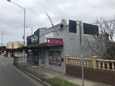
... ...Emu Road...Ballarat Road Commercial Street Curtin Street Emu Road Glida Street Hampstead Road Lyon Street Mitchell Street Maidstone Catholic Archdiocese of Melbourne Dobson Kindergarten Rogers Reserve Dobson Reserve Drey Park MacKillop Education Maidstone Campus New Apostolic Church Ernie's Supermarket Iglesia Ni Cristo - Locale of Melbourne Our Lady's Parish Hall Maidstone Child And Family Centre Jemena Zone Substation Worldwide Missionary Movement Melbourne Hillsong Melbourne West Warren And Brown 5592.01 - Ballarat Rd 3 - 5 Maidstone 2021 Photo 01.JPG 5592.02 - Ballarat Rd 17a Maidstone 2021 Photo 02.JPG 5592.03 - Ballarat Rd 27 - 29 Maidstone - Former Email Meters Factory 2021 Photo 01.JPG 5592.04 - Ballarat Rd 45 - Former Shop 2021 Photo 01.JPG 5592.05 - Ballarat Rd 49 - 57 Maidstone 2021 Photo 01.JPG 5592.06 - Ballarat Rd 63 - 65 Maidstone - Former Shop 2021 Photo 01.JPG 5592.07 - Ballarat Rd 81 Maidstone - Former Shop 2021 Photo 01.JPG 5592.08 - Ballarat Rd 101 Maidstone 2021 Photo 01.JPG 5592.09 - Ballarat Rd 115 Maidstone 2021 Photo 01.JPG 5592.10 - Ballarat Rd 127 - 131 Maidstone 2021 Photo 01.JPG 5592.11 - Ballarat Rd 46 Maidstone - Catholic Archdiocese of Melbourne 2021 Photo 01.JPG 5592.12 - Ballarat Rd 115 Maidstone 2021 Photo 02.JPG 5592.13 - Ballarat Rd 154 Maidstone - Former Shop 2021 Photo 01.JPG 5592.14 - Ballarat Rd 154 Maidstone - Former Shop 2021 Photo 02.JPG 5592.15 - Ballarat Rd 154 Maidstone - Former Shop 2021 Photo 03.JPG 5592.16 - Ballarat Rd 154 Maidstone - Former Shop 2021 Photo 04.JPG 5592.17 - Commercial St 1 - 11 Maidstone - Shops.JPG 5592.18 - Curtin St Maidstone - Fish And Chip Shop 2021 Photo 01.JPG 5592.19 - Dobson Kindergarten Rogers Reserve Maidstone 2021 Photo 01.JPG 5592.20 - Dobson Reserve 2021 Photo 05.JPG 5592.21 - Dobson Reserve 2021 Photo 06.JPG 5592.22 - Drey Park Maidstone 2021 Photo 01.JPG 5592.23 - Emu Rd 35 - 37 Maidstone 2021 Photo 01.JPG 5592.24 - Emu Rd 52 - 64 Maidstone 2021 Photo 01.JPG 5592.25 - Gilda St 10 - 12 Maidstone - MacKillop Education Maidstone Campus 2021 Photo 02.JPG 5592.26 - Hampstead Rd 2 - 8 Maidstone 2021 Photo 02.JPG 5592.27 - Hampstead Rd 2 Maidstone - Supermarket 2021 Photo 01.JPG 5592.28 - Hampstead Rd 5 Maidstone - New Apostolic Church 2021 Photo 01.JPG 5592.29 - Hampstead Rd 40 - Iglesia Ni Cristo - Locale of Melbourne 2021 Photo 01.JPG 5592.30 - Lyon St Maidstone - Our Lady's Parish Hall 2021 Photo 01.JPG 5592.31 - Maidstone Child And Family Centre Rogers Reserve Maidstone 2021 Photo 01.JPG 5592.32 - Mitchell St - Jemena Zone Substation BY 2021 Photo 01.JPG 5592.33 - Mitchell St 54 Maidstone - Worldwide Missionary Movement Melbourne 2021 Photo 01.JPG 5592.34 - Mitchell St 86 - 88 Maidstone 2021 Photo 01.JPG 5592.35 - Mitchell St 90 Maidstone - Hillsong Melbourne West 2021 Photo 01.JPG 5592.36 - Mitchell St 108 Maidstone - Warren And Brown 2021 Photo 01.JPG 5592.37 - Mitchell St 110 - 112 Maidstone 2021 Photo 01.JPG 5592.38 - Mitchell St 112 Maidstone 2021 Photo 01.JPG 5592.39 - Mitchell St 114 - 116 Maidstone 2021 Photo 01.JPG 5592.40 - Mitchell St 116 Maidstone 2021 Photo 01.JPG This is a large collection of photographs which has been split over three identification numbers. ...Maidstone was originally part of the former Shire of Braybrook and later the City of Sunshine. However, in 1994, Victoria underwent council amalgamations, which resulted in Braybrook being incorporated into the City of Maribyrnong. The suburb of Maidstone continues to attract considerable attention from the residents of City of Brimbank, particularly its historical features, the old buildings and distinctive streetscapes that characterise the area.To capture the essence of Maidstone in 2021, a series of photographs were taken. These images document a range of buildings, street scenes, and other notable points of interest throughout the suburb, providing a visual record of its unique character.5592.01 - Ballarat Rd 3 - 5 Maidstone 2021 Photo 01.JPG 5592.02 - Ballarat Rd 17a Maidstone 2021 Photo 02.JPG 5592.03 - Ballarat Rd 27 - 29 Maidstone - Former Email Meters Factory 2021 Photo 01.JPG 5592.04 - Ballarat Rd 45 - Former Shop 2021 Photo 01.JPG 5592.05 - Ballarat Rd 49 - 57 Maidstone 2021 Photo 01.JPG 5592.06 - Ballarat Rd 63 - 65 Maidstone - Former Shop 2021 Photo 01.JPG 5592.07 - Ballarat Rd 81 Maidstone - Former Shop 2021 Photo 01.JPG 5592.08 - Ballarat Rd 101 Maidstone 2021 Photo 01.JPG 5592.09 - Ballarat Rd 115 Maidstone 2021 Photo 01.JPG 5592.10 - Ballarat Rd 127 - 131 Maidstone 2021 Photo 01.JPG 5592.11 - Ballarat Rd 46 Maidstone - Catholic Archdiocese of Melbourne 2021 Photo 01.JPG 5592.12 - Ballarat Rd 115 Maidstone 2021 Photo 02.JPG 5592.13 - Ballarat Rd 154 Maidstone - Former Shop 2021 Photo 01.JPG 5592.14 - Ballarat Rd 154 Maidstone - Former Shop 2021 Photo 02.JPG 5592.15 - Ballarat Rd 154 Maidstone - Former Shop 2021 Photo 03.JPG 5592.16 - Ballarat Rd 154 Maidstone - Former Shop 2021 Photo 04.JPG 5592.17 - Commercial St 1 - 11 Maidstone - Shops.JPG 5592.18 - Curtin St Maidstone - Fish And Chip Shop 2021 Photo 01.JPG 5592.19 - Dobson Kindergarten Rogers Reserve Maidstone 2021 Photo 01.JPG 5592.20 - Dobson Reserve 2021 Photo 05.JPG 5592.21 - Dobson Reserve 2021 Photo 06.JPG 5592.22 - Drey Park Maidstone 2021 Photo 01.JPG 5592.23 - Emu Rd 35 - 37 Maidstone 2021 Photo 01.JPG 5592.24 - Emu Rd 52 - 64 Maidstone 2021 Photo 01.JPG 5592.25 - Gilda St 10 - 12 Maidstone - MacKillop Education Maidstone Campus 2021 Photo 02.JPG 5592.26 - Hampstead Rd 2 - 8 Maidstone 2021 Photo 02.JPG 5592.27 - Hampstead Rd 2 Maidstone - Supermarket 2021 Photo 01.JPG 5592.28 - Hampstead Rd 5 Maidstone - New Apostolic Church 2021 Photo 01.JPG 5592.29 - Hampstead Rd 40 - Iglesia Ni Cristo - Locale of Melbourne 2021 Photo 01.JPG 5592.30 - Lyon St Maidstone - Our Lady's Parish Hall 2021 Photo 01.JPG 5592.31 - Maidstone Child And Family Centre Rogers Reserve Maidstone 2021 Photo 01.JPG 5592.32 - Mitchell St - Jemena Zone Substation BY 2021 Photo 01.JPG 5592.33 - Mitchell St 54 Maidstone - Worldwide Missionary Movement Melbourne 2021 Photo 01.JPG 5592.34 - Mitchell St 86 - 88 Maidstone 2021 Photo 01.JPG 5592.35 - Mitchell St 90 Maidstone - Hillsong Melbourne West 2021 Photo 01.JPG 5592.36 - Mitchell St 108 Maidstone - Warren And Brown 2021 Photo 01.JPG 5592.37 - Mitchell St 110 - 112 Maidstone 2021 Photo 01.JPG 5592.38 - Mitchell St 112 Maidstone 2021 Photo 01.JPG 5592.39 - Mitchell St 114 - 116 Maidstone 2021 Photo 01.JPG 5592.40 - Mitchell St 116 Maidstone 2021 Photo 01.JPG ballarat road, commercial street, curtin street, emu road, glida street, hampstead road, lyon street, mitchell street, maidstone, catholic archdiocese of melbourne, dobson kindergarten, rogers reserve, dobson reserve, drey park, mackillop education maidstone campus, new apostolic church, ernie's supermarket, iglesia ni cristo - locale of melbourne, our lady's parish hall, maidstone child and family centre, jemena zone substation, worldwide missionary movement melbourne, hillsong melbourne west, warren and brown -
 Bendigo Historical Society Inc.
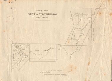
Document - MARKS COLLECTION: MAP OF PARISH OF STRATHFIELDSAYE 1858, 8th September, 1858
... Map shows Village Reserve on Emu Creek, road from Sandhurst, Sheepwash Creek and Splitters Creek. ...Map shows Village Reserve on Emu Creek, road from Sandhurst, Sheepwash Creek and Splitters Creek. ...Buff coloured document. On top 'Country Lands, Parish of Strathfieldsaye, County Unnamed'. On bottom 'Scale 40 chains to an inch. Public Lands Office, Melbourne Sept 8th. 1858. William Collis, Lith ( lithographer )'. Map shows Village Reserve on Emu Creek, road from Sandhurst, Sheepwash Creek and Splitters Creek. Wellington Hotel marked on map near intersection of Sheepwash Creek, Axe Creek and Emu Creek. Axe Creek Pound near Splitters Creek.map, bendigo, parish of strathfieldsaye 1858 -
 Sunshine and District Historical Society Incorporated
Archive - City of Sunshine Health Act Registration Schedule 1977, City of Sunshine, 1977
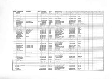
... Albans Hairdressers 69 Dumfries Street Deer Park Fish Shop 71 Dumfries Street Deer Park Milk Bar 73 Dumfries Street Deer Park Butcher 75 Dumfries Street Deer Park Coffee 113 Durham Road Sunshine Hairdresser Shop 1 117 Durham Road Sunshine Drinks Lot 1 Emu Road Maidstone Vending Machine Pridhams Sociel Club 11 Evans Street Braybrook Processing & Pack Dripping Pridhams 21 Evans Street Braybrook Gut Cleaning Pridhams 21 Evans Street Braybrook Rendering Works Pridhams 21 Evans Street Braybrook Storage & Soft Drink Sales 16 - 20 First Avenue Sunshine Sandwich Bar 30A First Avenue Sunshine Milk & Snack Bar 30A First Avenue Sunshine Vending Machine 106 Fitzgerald Road Sunshine West Mixed Business Lot 458 Fitzgerald Road Sunshine West Mixed Business Fitzgerald Road Sunshine West Butcher's Shop 26 Fiurlong Road Sunshine North Milk Bar / Mixed Business 154 Forrest Street Ardeer Milk Bar / Fish & Chips 222 Forrest Street Ardeer Milk Bar / Fish & Chips 222 Forrest Street Ardeer Vending Machine I.C.I. ...Albans Hairdressers 69 Dumfries Street Deer Park Fish Shop 71 Dumfries Street Deer Park Milk Bar 73 Dumfries Street Deer Park Butcher 75 Dumfries Street Deer Park Coffee 113 Durham Road Sunshine Hairdresser Shop 1 117 Durham Road Sunshine Drinks Lot 1 Emu Road Maidstone Vending Machine Pridhams Sociel Club 11 Evans Street Braybrook Processing & Pack Dripping Pridhams 21 Evans Street Braybrook Gut Cleaning Pridhams 21 Evans Street Braybrook Rendering Works Pridhams 21 Evans Street Braybrook Storage & Soft Drink Sales 16 - 20 First Avenue Sunshine Sandwich Bar 30A First Avenue Sunshine Milk & Snack Bar 30A First Avenue Sunshine Vending Machine 106 Fitzgerald Road Sunshine West Mixed Business Lot 458 Fitzgerald Road Sunshine West Mixed Business Fitzgerald Road Sunshine West Butcher's Shop 26 Fiurlong Road Sunshine North Milk Bar / Mixed Business 154 Forrest Street Ardeer Milk Bar / Fish & Chips 222 Forrest Street Ardeer Milk Bar / Fish & Chips 222 Forrest Street Ardeer Vending Machine I.C.I. ...The City of Sunshine Health Inspector had a broad mandate to protect public health across the municipality. Their duties included inspecting food premises such as: - Restaurants - Cafés - Takeaway shops - Milk bars - Supermarkets - Food vans - Market stalls They checked for: - Safe food handling practices - Correct storage temperatures (hot and cold holding) - Cleanliness of food preparation areas - Pest control and vermin prevention - Staff hygiene and hand‑washing facilities - Proper waste and grease‑trap management These inspections were carried out under the Food Act and local by‑laws. This list of businesses in the City of Sunshine is an extract from a report by the City of Sunshine Health Inspector in 1977.This report records the business name, type of business and address of businesses operating in the City of Sunshine in 1977.Milk Bar 62 Adelaide Street Albion Fruiterer 26 Amelia Avenue Deer Park Milk Bar 133 Anderson Road Albion Milk Bar / Mixed Business 11 Ardoyne Street Sunshine Milk Bar / Mixed Business 11 Ardoyne Street Sunshine Vending Machine National Springs 185 - 195 Ashley Street Braybrook Vending Machine Harland Engineering Ashley Street Braybrook Hairdressers 511 Ballarat Road Albion Fish & Chips 513 Ballarat Road Albion Food Premises 580 Ballarat Road Albion Motor Wrecking 584 Ballarat Road Albion Licensed Grocer 501 - 507 Ballarat Road Albion Vending Machine Swingbridge Motors Ballarat Road Albion Eating House Highway Inn Motel 608 Ballarat Road Ardeer Milk Bar / Kiosk Apollo Gardens 610 Ballarat Road Ardeer Camping Area Caravan Park 610 Ballarat Road Ardeer Vending Machine McEwans 614 Ballarat Road Ardeer Snack Foods Manufacturer 254 Ballarat Road Braybrook Vending Machine Dyecraft 265 Ballarat Road Braybrook Milk Bar 282 Ballarat Road Braybrook Hairdresser 284 Ballarat Road Braybrook Food Premises 290 Ballarat Road Braybrook Retail Butcher 292 Ballarat Road Braybrook Vending Machine D. Richardson & Sons 330 Ballarat Road Braybrook Eating House D. Richardson & Sons 330 Ballarat Road Braybrook Vending Machine D. Richardson & Sons 330 Ballarat Road Braybrook Fish Shop 306A Ballarat Road Braybrook Milk Bar 306A Ballarat Road Braybrook Vending Machine 463 Ballarat Road Deer Park Eating House ICI Recreation Club 770 Ballarat Road Deer Park Retail Butcher Star Butchers 807 Ballarat Road Deer Park Licensed Grocery 809 Ballarat Road Deer Park Milk Bar / Mixed Business 813 Ballarat Road Deer Park Milk Bar / Mixed Business 815 Ballarat Road Deer Park Fruiterer 817 Ballarat Road Deer Park Milk Bar & Delicatessen 825 Ballarat Road Deer Park Milk Bar 825 Ballarat Road Deer Park Milk Bar 825 Ballarat Road Deer Park Fish & Chips 801A Ballarat Road Deer Park Fish & Chip Shop 801A Ballarat Road Deer Park Eating House 801B Ballarat Road Deer Park Fruit Shop 807A Ballarat Road Deer Park Vending Machine Goldern Fleece Service Station Ballarat Road Deer Park Hairdressers 5 Ballarat Road Maidstone Mixed Business 83 Ballarat Road Maidstone Butcher's Shop 151 Ballarat Road Maidstone Mixed Business 154 Ballarat Road Maidstone Mixed Business 193 Ballarat Road Maidstone Grocery Retail 129 - 131 Ballarat Road Maidstone Milk Bar 49A Ballarat Road Maidstone Food Premises 361 Ballarat Road Sunshine Mens Hairdresser Shop 363 Ballarat Road Sunshine Vending Machine B.P. Westbound 439 Ballarat Road Sunshine Eating House 459 Ballarat Road Sunshine Milk Bar / Mixed Business 469 Ballarat Road Sunshine Fish Shop 471 Ballarat Road Sunshine Mixed Business Food 473 Ballarat Road Sunshine Wholesale Egg Store 479 Ballarat Road Sunshine Vending Machine Sunshine Cabinet Works 503 Ballarat Road Sunshine Apartment House Caravan Park 610 Ballarat Road Sunshine Take Away Food Kentucky Fried Chicken 429A Ballarat Road Sunshine Vending Machine Mobil Service Station 432 Ballarat Road Sunshine North Vending Machine Spaldings 480 Ballarat Road Sunshine North Vending Machine Ajax Nettlefolds 484 Ballarat Road Sunshine North Eating House Ajax Nettlefolds 484 Ballarat Road Sunshine North Vending Machine National Food Service Nettlefolds 484 Ballarat Road Sunshine North Vending Machine Nettlefolds 484 Ballarat Road Sunshine North Eating House McDonalds 400 - 402 Ballarat Road Sunshine North Motor Wrecking Ballarat Road Cnr Carrington Drive Albion Mixed Business Ballarat Road Cnr Churchill Avenue Maidstone Eating House Ballarat Road Cnr Holt Street Ardeer Mixed Business 23 Beachley Street Braybrook Milk Bar 31 Beachley Street Braybrook Fish Shop 33 Beachley Street Braybrook Fish & Chips 3 Bell Street Sunshine West Greengrocer 1A Bell Street Sunshine West Butchers 1D Bell Street Sunshine West Milk Bar 61 Berkshire Road Sunshine North Vending Machine Rockwell Axles Berkshire Road Sunshine North Bulk Tallow Plant Burke Road Braybrook Soap Manufacturing Pennell 43 - 45 Burke Street Braybrook Vending Machine G.U.D. Burton Cresent Maribyrnong Motor Wrecking 18 Carrington Drive Albion Butcher 162 Churchill Avenue Braybrook Bakery & Shop 166 Churchill Avenue Braybrook Ladies Hairdressers 174 Churchill Avenue Braybrook Fish & Chip Shop 176 Churchill Avenue Braybrook Licenced Grocery 158 - 160 Churchill Avenue Braybrook Milk Bar / Mix Business 170 - 172 Churchill Avenue Braybrook Fishmonger 8 City Place Sunshine Butcher's Shop S.S. Meats 11 City Place Sunshine Retail Fish Sunshine Market 13 City Place Sunshine Retail Health Foods Sunshine Market 13 City Place Sunshine Retail Fruit / Eggs Stalls 3, 10 & 11 Sunshine Market 15 City Place Sunshine Delicatessen Sunshine Market 17 City Place Sunshine Supermarket Safeway 7 Clarke Street Sunshine Vending Machine Safeway 7 Clarke Street Sunshine Butcher 8 Clarke Street Sunshine Butcher Storeroom / Factory 11 Clarke Street Sunshine Hairdresser Room 7 2A Clarke Street Sunshine Milk Bar 1 Commercial Street Maidstone Hairdressers 7 Commercial Street Maidstone Chiropodist Corio Street Sunshine Chiropodist 39 Cornwall Road Sunshine North Gut Cleaning 37 Cranwell Street Braybrook Fat Extracting 37 Cranwell Street Braybrook Boiling Down 37 Cranwell Street Braybrook Piggery 37 Cranwell Street Braybrook Storage Canned Food 37 Cranwell Street Braybrook Packaging Food Products Cranwell Street Cnr Errol Street Braybrook Food Packing Southern Packages Cranwell Street Cnr Errol Street Braybrook Milk Bar / Mixed Business 24 Cypress Avenue Brooklyn Milk Bar 24 Cypress Avenue Brooklyn Vending Machine Steelcraft Baby Carriages 99 Derby Road Sunshine Ladies Hairdressers 110 Derby Road Sunshine Vending Machine Raleigh Nursery Derby Road Cnr Thorpe Street Sunshine Eating House Raleigh Nursery Derby Road Cnr Thorpe Street Sunshine Vending Machine Massey Ferguson 2 Devonshire Road Sunshine Vending Machine Sunshine Post Office 5 Devonshire Road Sunshine Milk Bar / Mixed Business 100 Devonshire Road Sunshine Vending Machine Massey Ferguson Devonshire Road Sunshine Milk Bar 5 Dickson Street Sunshine Fruit Shop 15 Dickson Street Sunshine Food Premises 27 Disraeli Street St. Albans Hairdressers 69 Dumfries Street Deer Park Fish Shop 71 Dumfries Street Deer Park Milk Bar 73 Dumfries Street Deer Park Butcher 75 Dumfries Street Deer Park Coffee 113 Durham Road Sunshine Hairdresser Shop 1 117 Durham Road Sunshine Drinks Lot 1 Emu Road Maidstone Vending Machine Pridhams Sociel Club 11 Evans Street Braybrook Processing & Pack Dripping Pridhams 21 Evans Street Braybrook Gut Cleaning Pridhams 21 Evans Street Braybrook Rendering Works Pridhams 21 Evans Street Braybrook Storage & Soft Drink Sales 16 - 20 First Avenue Sunshine Sandwich Bar 30A First Avenue Sunshine Milk & Snack Bar 30A First Avenue Sunshine Vending Machine 106 Fitzgerald Road Sunshine West Mixed Business Lot 458 Fitzgerald Road Sunshine West Mixed Business Fitzgerald Road Sunshine West Butcher's Shop 26 Fiurlong Road Sunshine North Milk Bar / Mixed Business 154 Forrest Street Ardeer Milk Bar / Fish & Chips 222 Forrest Street Ardeer Milk Bar / Fish & Chips 222 Forrest Street Ardeer Vending Machine I.C.I. Detonating Fuse Factory Forrest Street Ardeer Vending Machine Connor-Shea 25 Fourth Avenue Sunshine Abattoir Thomas Borthwick & Sons 405 Francis Street Brooklyn Butcher's Shop Thomas Borthwick & Sons 405 Francis Street Brooklyn Eating House Borthwicks 405 Francis Street Brooklyn Abattoirs & Skaughterhouse Borthwicks 405 Francis Street Brooklyn Skin Store & Hide Treatment, Storage & Packing Borthwicks 405 Francis Street Brooklyn Boiling Down Meal, Dried Blood & Offals Borthwicks 405 Francis Street Brooklyn Fat Rendering Borthwicks 405 Francis Street Brooklyn Gut Rendering Borthwicks 405 Francis Street Brooklyn Vending Machine Dalgetys & Co 4 Frederick Street Brooklyn Take Away Food 28 Furlong Road Sunshine North Milk Bar / Mix Business 42 Furlong Road Sunshine North Vending Machine Parkhill Supermarket 18 - 22 Furlong Road Sunshine North Vending Machine Parkhill Supermarket 18 - 22 Furlong Road Sunshine North Supermarket & Storage Parkhill Supermarket 18 - 22 Furlong Road Sunshine North Vending Machine Tasman U.E.B. Industries 512 Geelong Road Brooklyn Take Away Food 553 Geelong Road Brooklyn Pizza 555 Geelong Road Brooklyn Warehouse Halfcase Warehouse 564 Geelong Road Brooklyn Vending Machine D.H. Opperman 568 Geelong Road Brooklyn Abattoirs J.H. Ralph & Sons 690 Geelong Road Brooklyn Boling Down Works J.H. Ralph & Sons 690 Geelong Road Brooklyn Piggery J.H. Ralph & Sons 690 Geelong Road Brooklyn Take Away Food 710 Geelong Road Brooklyn Vending Machine Internatioal Harvester Geelong Road Cnr McDonalds Road Brooklyn Milk Bar / Mixed Business 72 Glengala Road Sunshine West Hot Bread Shop Western & Continental Bread 78 Glengala Road Sunshine West Licenced Grocer 79 Glengala Road Sunshine West Milk Bar / Mixed Business 83 Glengala Road Sunshine West Milk Bar 85 Glengala Road Sunshine West Ladies Hairdressers 89 Glengala Road Sunshine West Eating House 93 Glengala Road Sunshine West Catering & Pastry Cook St. Albans Catering Service 95 Glengala Road Sunshine West Food Premises 142 Glengala Road Sunshine West Mixed Business 36 Hampshire Road Sunshine Eating House 44 Hampshire Road Sunshine Milk Bar 72 Hampshire Road Sunshine Hairdressers 76 Hampshire Road Sunshine Butcher 78 Hampshire Road Sunshine Fat Rendering 78 Hampshire Road Sunshine Fruit Shop 84 Hampshire Road Sunshine Fish Shop 86 Hampshire Road Sunshine Fish & Chip Shop 86 Hampshire Road Sunshine Eating House 90 Hampshire Road Sunshine Eating House 90 Hampshire Road Sunshine Vending Machine Shell Service Station 130 Hampshire Road Sunshine Pizza Restaurant 197 Hampshire Road Sunshine Eating House 209 Hampshire Road Sunshine Hot Bread Shop 217 Hampshire Road Sunshine Eating House 235 Hampshire Road Sunshine Butchery 244 Hampshire Road Sunshine Food Premises Caprile Meat Supply 244 Hampshire Road Sunshine Retail Liquor Sunshine Cellars 246 Hampshire Road Sunshine Delicatessen 252 Hampshire Road Sunshine Pie Manufacturer & Slaes 260 Hampshire Road Sunshine Milk Bar 266 Hampshire Road Sunshine Mens Hairdresser Shop Shop 7 Kontek Arcade 266 Hampshire Road Sunshine Vending Machine 266 Hampshire Road Sunshine Fruit Shop 268 Hampshire Road Sunshine Fruit & Vegetables 268 Hampshire Road Sunshine Hairdresser 277 Hampshire Road Sunshine Vending Machine Woolworths 282 Hampshire Road Sunshine Vending Machine Woolsworths Variety Store 282 Hampshire Road Sunshine Supermarket S.E. Dickens 294 Hampshire Road Sunshine Vending Machine 294 Hampshire Road Sunshine Butchery 252A Hampshire Road Sunshine Vending Machine G.J. Coles 254 - 258 Hampshire Road Sunshine Retail / Variety Store Coles 254 - 258 Hampshire Road Sunshine Vending Machine Coles 254 - 258 Hampshire Road Sunshine Vending Machine Coles Variety Store 254 - 258 Hampshire Road Sunshine Variety / Confectionary Woolworths 282 - 286 Hampshire Road Sunshine Vending Machine Dickens Supermarket 294 - 296 Hampshire Road Sunshine Vending Machine New World 294 - 296 Hampshire Road Sunshine Vending Machine Target Hampshire Road Sunshine Warehouse 7 Hampstead Road Maidstone Wholesale & Retail Selling Ernie's Supermarket 8 Hampstead Road Maidstone Vending Machine Ernie's Fruit Market 8 Hampstead Road Maidstone Vending Machine Ralph McKay Social Club 36 Hampstead Road Maidstone Food Premises 34A Hampstead Road Maidstone Mixed Business 110 Hertford Road Sunshine Warehouse 12 - 14 Hertford Road Sunshine Catering Service 45 Holt Street Ardeer Licenced Grocery / Milk Bar / Sub News / Post Office 49 Holt Street Ardeer Continental Butcher 51 Holt Street Ardeer Fish & Chips 59 Holt Street Ardeer Mixed Business 61 Holt Street Ardeer Fruit & Vegetables 51A Holt Street Ardeer Eating House W.L. Allen Foundry 3 Hulett Street Albion Mixed Business 56 King Edward Avenue Albion Milk Bar / Mixed Business 8 King Street Braybrook Milk Bar / Mixed Business 50 Links Street Sunshine West Milk Bar / Mixed Business 50 Links Street Sunshine West Ladies Hairdressers Shop 7 St. Albans Arcade 323 Main Road East St. Albans Ladies Hairdressers St. Albans Arcade 323 Main Road East St. Albans Mens Hairdresser Shop Shop 6 St. Albans Arcade 323 Main Road East St. Albans Vending Machine Woolworths 329 Main Road East St. Albans Mixed Business 57 Main Road West St. Albans Greengrocer 61 Main Road West St. Albans Butcher Shop / Smallgoods Manufacturer 75 Main Road West St. Albans Eating House 85 Main Road West St. Albans Hairdressing Salon 111 Main Road West St. Albans Milk Bar / Mix Business 113 Main Road West St. Albans General Store 171 Main Road West St. Albans Food Premises 173 Main Road West St. Albans Milk Bar / Mixed Business 179 Main Road West St. Albans Butcher / Continental Delicatessen 323 Main Road West St. Albans Mixed Business 175 - 177 Main Road West St. Albans Butcher's Shop 177A Main Road West St. Albans Ladies Hairdressers 61 - 63 Main Road West St. Albans Fruit & Vegetables 7 Market Place Braybrook Milk Bar 9 Market Place Braybrook Butcher Shop 11 Market Place Braybrook Butcher's Shop 11 Market Place Braybrook Fish Shop 15 Market Place Braybrook Eating House 1 Market Road Sunshine Food Premises 1 Market Road Sunshine Vending Machine R.M.D. Press 8 Market Road Sunshine Food Premises Wholesale Self Service 20 Market Road Sunshine Butcher Shop 29 Maxwell Street Ardeer Milk Bar / Post Office / Sub News 31 Maxwell Street Ardeer Mixed Business 31 Maxwell Street Ardeer Butcher / Delicatessen 52 Maxwell Street Ardeer Mixed Business 58 Maxwell Street Ardeer Butcher's Shop 29A Maxwell Street Ardeer Greengrocer 29B Maxwell Street Ardeer Licensed Grocery 31A Maxwell Street Ardeer Refrigerated Storage Sascol 41 McDonald Road Brooklyn Eating House McDonald Road Brooklyn Vending Machine Wunderlich 47 McIntyre Road Sunshine Vending Machine Taubmans Paints 51 McIntyre Road Sunshine North Milk Bar / Mixed Business 59 McIntyre Road Sunshine North Ladies Hairdressers 63 McIntyre Road Sunshine North Hairdressers 65 McIntyre Road Sunshine North Milk Bar 67 McIntyre Road Sunshine North Food Premises 69 McIntyre Road Sunshine North Fish & Chips 69 McIntyre Road Sunshine North Butcher Shop / Retail 75 McIntyre Road Sunshine North Greengrocer 81 McIntyre Road Sunshine North Milk Bar 83 McIntyre Road Sunshine North Food Factory Routley 119 McIntyre Road Sunshine North Bakery 119 McIntyre Road Sunshine North Eating House 129 McIntyre Road Sunshine North Vending Machine Sankey Benson McIntyre Road Sunshine North Ladies Hairdressers 57 Metherall Street Sunshine North Mixed Business 30 Millers road Brooklyn Milk Bar Millers Road Cnr Francis Street Brooklyn Dairy 6 Mitchell Street Maidstone Vending Machine Repco Dynamics 85 Mitchell Street Maidstone Vending Machine Repco Equipment 85 Mitchell Street Maidstone Take Away Food 124 Mitchell Street Maidstone Fish & Chips 130 Mitchell Street Maidstone Retail Butcher 132 Mitchell Street Maidstone Milk Bar 138 Mitchell Street Maidstone Ice Manufacturer Maidstone Ice Works 162 Mitchell Street Maidstone Milk Bar / Sub News / Mixed Business 1 Monash Street Sunshine Vending Machine 1 Monash Street Sunshine Milk Bar / Mixed Business 48 Monash Street Sunshine Vending Machine 48 Monash Street Sunshine Fish & Chips 50 Monash Street Sunshine Fish & Chips 50 Monash Street Sunshine Milk Bar / Grocery 106 Monash Street Sunshine Milk Bar / Mixed Business 106 Monash Street Sunshine Food Premises Slade Soft Drinks 54 - 56 Monash Street Sunshine Hairdresser's Shop 58A Monash Street Sunshine Mixed Business 4 Mulhall Drive St. Albans Milk Bar 79 Mulhall Drive St. Albans Milk Bar 79 Mulhall Drive St. Albans Mixed Business / Sub News 5 Northumberland Road Sunshine North Greengrocer 9 Northumberland Road Sunshine North Mixed Business 13 Northumberland Road Sunshine North Vending Machine 13 Northumberland Road Sunshine North Milk Bar 61 Northumberland Road Sunshine North Licenced Grocer 15 - 17 Northumberland Road Sunshine North Butcher's Shop 21A Northumberland Road Sunshine North Hairdresser's Shop 23A Northumberland Road Sunshine North Hairdressing Salon 23A Northumberland Road Sunshine North Fish & Chips 23B Northumberland Road Sunshine North Chiropodist 25 Norwood Street Albion Eating House Medway Golf Club 57 Omar Street Maidstone Vending Machine British Leyland Paramount Road Footscray West Hairdresser 35 Perth Avenue Albion Greengrocer 37 Perth Avenue Albion Retail Butcher 41 Perth Avenue Albion Mixed Business 43 Perth Avenue Albion Mixed Business 1 Porter Court Deer Park Milk Bar / Mixed Business / Sub News 42 Raleigh Road Maribyrnong Eating House Maribrnong R.S.L. 56 Raleigh Road Maribyrnong Milk Bar / Mixed Business 85 Raleigh Road Maribyrnong Milk Bar / Mixed Business 42 - 44 Raleigh Road Maribyrnong Eating House Sunshine Golf Club Ralph Street Sunshine West Vending Machine Sunshine Golf Club Ralph Street Sunshine West Vending Machine Law Somner (Hortico) Raymond Road Brooklyn Milk Bar / Food Premises 39 Rhodes Street St. Albans Vending Machine Maribyrnong High School 2 River Street Maribyrnong Supermarket S.E. Dickens 1 Rosamond Road Maidstone Vending Machine New World 1 Rosamond Road Maidstone Milk Bar 31 Rosamond Road Maidstone Butchers 77 Rosamond Road Maidstone Milk Bar 99 Rosamond Road Maidstone Food Premises 99 Rosamond Road Maidstone Eating House 101 Rosamond Road Maidstone Fish & Chip Shop 103 Rosamond Road Maidstone Milk Bar / Mixed Business 123 Rosamond Road Maidstone Vending Machine Dickens Supermarket 1 - 7 Rosamond Road Maidstone Vending Machine Dickens Supermarket 1 - 7 Rosamond Road Maidstone Fish & Chip Shop 103 Rosamond Road Maribyrnong Fruit & Vegetables 151 Rosamond Road Maribyrnong Vending Machine Vickers Hydraulics 160 Rosamond Road Maribyrnong Eating House Sperry Victers 169 Rosamond Road Maribyrnong Eating House Sunset Drive In 179 Rosamond Road Maribyrnong Vending Machine Sperry Victers 189 Rosamond Road Maribyrnong Fruit Shop 224 Rosamond Road Maribyrnong Retail Supermarket Target Highpoint West Shopping Centre 120 - 200 Rosamond Road Maribyrnong Cakes & Takeaway Food Shop 97 Highpoint West Shopping Centre 120 - 200 Rosamond Road Maribyrnong Butcher's Shop Shop 23 Level 2 Highpoint West Shopping centre 120 - 200 Rosamond Road Maribyrnong Eating House Shop 222 Highpoint West Shopping Centre 120 - 200 Rosamond Road Maribyrnong Food Premises Shop 97 Highpoint West Shopping Centre 120 - 200 Rosamond Road Maribyrnong Eating House Shop 85 Highpoint West Shopping Centre 120 - 200 Rosamond Road Maribyrnong Retail Butcher Gilbertons Shop 25 Highpoint City Shopping Centre 120 - 200 Rosamond Road Maribyrnong Retail Butcher Gilbertons Shop 39 Highpoint City Shopping Centre 120 - 200 Rosamond Road Maribyrnong Food Premises Shop B212 Highpoint City Shopping Centre 120 - 200 Rosamond Road Maribyrnong Confectionary / Variety Woolworths 120 - 200 Rosamond Road Maribyrnong Eating House Myers High Highpoint West Shopping Centre 120 - 200 Rosamond Road Maribyrnong Eating House McDonalds High Highpoint West Shopping Centre 120 - 200 Rosamond Road Maribyrnong Supermarket Safeway Highpoint West Shopping Centre 120 - 200 Rosamond Road Maribyrnong Eating House Target Highpoint West Shopping Centre 120 - 200 Rosamond Road Maribyrnong Eating House Shop 222 Highpoint West Shopping Centre 120 - 200 Rosamond Road Maribyrnong Hairdressers Myers High Highpoint West Shopping Centre 120 - 200 Rosamond Road Maribyrnong Retail Food Sales Myers High Highpoint West Shopping Centre 120 - 200 Rosamond Road Maribyrnong Vending Machine Target Highpoint West Shopping Centre 120 - 200 Rosamond Road Maribyrnong Vending Machine Target Highpoint West Shopping Centre 120 - 200 Rosamond Road Maribyrnong Vending Machine Woolsworths Highpoint City West Shopping Centre 120 - 200 Rosamond Road Maribyrnong Milk Bar / Mixed Business 1 Rowe Street Maidstone Kiosk Sunshine Swimming Pool 13 Service Street Sunshine Vending Machine Maidstone Police Station 8 Short Street Maidstone Eating House Drive In 2 Somers Street Sunshine Vending Machine Collins Davey Motors 410 Somerville Road Brooklyn Storage Woodsheds 53, 54, 55, 56, 57 & 58 422 - 426 Somerville Road Brooklyn Vending Machine P. & S. Seigal Somerville Road Brooklyn Eating House Monsanto 423 Somerville Road Footscray West Vending Machine Monsanto Chemicals 423 Somerville Road Footscray West Eating House Australia National Forge (ANI) 465 Somerville Road Footscray West Food Cannery S.C.I. Meat & Paper 433 - 451 Somerville Road Footscray West Wholesale Meat Depot S.C.I. Meat & Paper 433 - 451 Somerville Road Footscray West Wholesale Meat Depot J.A. Mason 433 - 451 Somerville Road Footscray West Abattiors S.C.I. Meat & Paper 433 - 451 Somerville Road Footscray West Skin Store S.C.I. Meat & Paper 433 - 451 Somerville Road Footscray West Boling Down Works - Blood, Bones & Offal S.C.I. Meat & Paper 433 - 451 Somerville Road Footscray West Vending Machine Nestles Shed 58 Somerville Road Footscray West Eating House Somerville Road Footscray West Vending Machine Industrial Engineering 6 South Road Braybrook Eating House Invicta Mills 38 South Road Braybrook Vending Machine Invicta Mills 38 South Road Braybrook Milk Bar 105 South Road Braybrook Milk Bar / Delicatessen 105 South Road Braybrook Greengrocer 107 South Road Braybrook Fish Shop 109 South Road Braybrook Milk Bar 111 South Road Braybrook Milk Bar 111 South Road Braybrook Hairdresser Shop 121 South Road Braybrook Self Service Grocery 125 South Road Braybrook Retail Butcher 127 South Road Braybrook Retail Greengrocery 129 South Road Braybrook Hairdresser / Beautry Parlour 131 South Road Braybrook Bakery 133 South Road Braybrook Milk Bar 125A South Road Braybrook Preparked Grocery Foods Stall 22 - 23 St. Albans Market 3 St. Albans Road St. Albans Poultry Stall 4 St. Albans Market 3 St. Albans Road St. Albans Fruit & Vegetables Stalls 31 & 32 St. Albans Market 3 St. Albans Road St. Albans Eating House Stall 13 St. Albans Market 3 St. Albans Road St. Albans Eating House Stall 14 St. Albans Market 3 St. Albans Road St. Albans Delicatessen Stall 15 St. Albans Market 3 St. Albans Road St. Albans Butcher Stall 3 St. Albans Market 3 St. Albans Road St. Albans Food Retailers Shop 9 St. Albans Market 3 St. Albans Road St. Albans Food Retailers Shops 5 & 6 St. Albans Market 3 St. Albans Road St. Albans Retail Fish Store Stall 2 St. Albans Market 3 St. Albans Road St. Albans Delicatessen Stalls 11 & 12 St. Albans Market 3 St. Albans Road St. Albans Butchery Stall 1 St. Albans Market 3 St. Albans Road St. Albans Vending Machine Big Sams Market Shop 13 St. Albans 3 St. Albans Road St. Albans Eating House 57 St. Albans Road St. Albans Pizza Parlour 57 St. Albans Road St. Albans Vending Machine 59 St. Albans Road St. Albans Mixed Business 61 St. Albans Road St. Albans Vending Machine 272 St. Albans Road St. Albans Eating House 22 - 26 St. Albans Road St. Albans Snack Bar St. Albans Market 5A St. Albans Road St. Albans Vending Machine Vinidex Tubemakers 231 - 245 St. Albans Road Sunshine North Vending Machine Tubemakers 231 - 245 St. Albans Road Sunshine North Vending Machine Lysaght Steel 323 - 325 St. Albans Road Sunshine North Hairdressers 52 Station Place Sunshine Eating House 54 - 56 Station Place Sunshine Hairsdresser's Shop 75 Station Road Deer Park Dairy Dairy 78 Station Road Deer Park Butcher Retail 87 Station Road Deer Park Fish Shop 94 Station Road Deer Park Mixed Business 98 Station Road Deer Park Vending Machine 98 Station Road Deer Park Vending Machine 100 Station Road Deer Park Vending Machine Deer Park Swimming Pool 119 Station Road Deer Park Piggery University of Melbourne 475 Station Road Deer Park Hairdresser Shop 87A Station Road Deer Park Ladies Hairdressers 93A Station Road Deer Park Vending Machine Nylex Corporation Station Road Deer Park Vending Machine ICI of A&NZ Station Road Deer Park Vending Machine Nylex Corporation Station Road Deer Park Hairdressers 41 Stradbroke Drive St. Albans Milk Bar / Mixed Business 44 Stradbroke Drive St. Albans Milk Bar 52 Stradbroke Drive St. Albans Fish & Chips 54 Stradbroke Drive St. Albans Milk Bar 24 Studley Street Maidstone Milk Bar / Post Office 15 Suffolk Road Sunshine North Licenced Grocer 17 Suffolk Road Sunshine North Hairdresser Shop 19 Suffolk Road Sunshine North Fruit Shop 21 Suffolk Road Sunshine North Mixed Business 35 Suffolk Road Sunshine North Butcher's Shop 15A Suffolk Road Sunshine North Retail Butchery 15A Suffolk Road Sunshine North Grocery / Delicatessen 23A Suffolk Road Sunshine North Mixed Businss 74 Suffolk Street Maidstone Vending Machine 25 Suffolk Street Sunshine Mens Hairdresser Shop 11 Sun Crescent Sunshine Eating House 19 Sun Crescent Sunshine Eating House 21 Sun Crescent Sunshine Retail Fruit & Vegetable Shop 23 Sun Crescent Sunshine Licensed Grocery 27 Sun Crescent Sunshine Sale of Coffee 21A Sun Crescent Sunshine Vending Machine Sunshine Police Station Sun Crescent Sunshine Supermarket Sims Markette 20 Sun Crescent Sunsnine Camping Area Sunshine Caravan Park 280 Sunshine Road Sunshine Hairdresser 169 Sunshine Road Tottenham Licensed Grocery Sales 171 Sunshine Road Tottenham Retail Butcher 175 Sunshine Road Tottenham Milk Bar & Mixed Business 177 Sunshine Road Tottenham Hairdressers Shop 179 Sunshine Road Tottenham Ladies Hairdressers 183 Sunshine Road Tottenham Eating House 193 Sunshine Road Tottenham Vending Machine Olex Cables 207 Sunshine Road Tottenham Eating House Olex Cables 207 Sunshine Road Tottenham Vending Machine Olex Cables 207 Sunshine Road Tottenham Vending Machine Wiltshire Files 213 Sunshine Road Tottenham Eating House McPherson's / Ajax Pumps 217 Sunshine Road Tottenham Pizza Eating House 179A Sunshine Road Tottenham Vending Machine Quaker Foods Sunshine Road Tottenham Milk Bar 21 Sydney Street Albion Milk Bar / Food Premises 32 Sydney Street Albion Mixed Business 67 Sydney Street Albion Flour Milliing & Packaging John Darling & Son 74 Sydney Street Albion Butcher 30A Sydney Street Albion Fish & Chips / Pizza Take Away Food Shop 7 2 - 16 Tallintyre Road Sunshine West Mil Bar / Mixed Business 2 - 16 Tallintyre Road Sunshine West Supermarket & Butcher Shop 2 - 16 Tallintyre Road Sunshine West Eating House Sunshine Baseball Club 5 Talmage Street Albion Eating House Sunshine City Club 24 Talmage Street Albion Mixed Business 28 Thomson Street Maidstone Hairdressers 28A Thomson Street Maidstone Canned Meat Storaage S.C.I. Meat & Paper Warehouses 1, 2 & 3 3 Victoria Drive Footscray West Vending Machine Cargo Newpack Industries Victoria Drive Footscray West Dairy Richards Dairy 39 Wallace Street Maidstone Milk Bar 68 Warwick Road Sunshine North Butcher's Shop 70 Warwick Road Sunshine North Hairdressers 72 Warwick Road Sunshine North Milk Bar / Business 76 Warwick Road Sunshine North Milk Bar 76 Warwick Road Sunshine North Fish & Chips 78 Warwick Road Sunshine North Butcher 80 Warwick Road Sunshine North Licenced Food Store 82 Warwick Road Sunshine North Hairdresser Shop 7 Durham Road Watt Street Sunshine Vending Machine Westbury Timber 18 Williamson Road Maribyrnong Milk Bar 91 Wright Street Sunshine -
 Warrnambool and District Historical Society Inc.
Medal - Cycling Medals W. S. Toyne
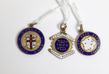
... Road Race 1923; Reverse W. S. Toyne [.1] Round metal and enamel medal with blue enamel edge and an unidentified white coat of arms with a red cross containing five stars on the obverse side. The shield is held by an embossed kangaroo on the left and an emu ...These cycling medals were awarded to W. S. Toyne. Two of these medals are time medallions relating to the Warrnambool to Melbourne Cycle Race. This race was first held in 1895 and continues to the present day. It was originally a handicap race from Warrnambool to Melbourne but after 1938 it became a Melbourne to Warrnambool race. After 1995 it became a scratch race and today the distance is shorter with the race starting from Avalon. It is the second oldest one-day cycling race in the world and the longest one-day cycling race in Australia. All riders who complete the race in a given time are awarded a Time Medallion. The race was sponsored by the Dunlop company from 1901 to 1927. In 1923, 123 of the 196 riders, who started at 5:30am completed the 165 mile road race and were awarded the time medallion. W. S. Toyne was listed among the some of the first cyclists to go through Camperdown at 8:16am. It was reported that over 50,000 spectators witnessed the progress of the race. These cycling medals belonged to a cyclist, W. S. Toyne, who completed in a significant sporting event in Warrnambool in 1923 and 1924. [.1] Round metal and enamel medal with blue enamel edge and an unidentified white coat of arms with a red cross containing five stars on the obverse side. The shield is held by an embossed kangaroo on the left and an emu on the right. The reverse is inscribed with name and time in an inner circle and the year and race on the outer edge. [.2] Round metal and enamel medal with blue enamel edge and a white enamel shield containing five stars in the centre of the obverse side. The reverse is inscribed with the name and time in the inner circle and the race name on the outer edge. [.3] metal and enamel medal with a blue enamel circle with white enamel boomerangs sitting above and below.[.1] Obverse: Dunlop Road Race; Reverse: Warrnambool-Melbourne Time Medallion 1924 Won by W. S. Toyne 5 Hrs. 47 Mns. 42 Sds. [.2] Obverse: Dunlop Road Race 1923; Reverse: Warrnambool-Melbourne Time Medallion; Won by W. S. TOYNE 10 Hrs. 30 Mns. Sds. [.3] Obverse: Barnet Glass Ballarat-Melbourne Road Race 1923; Reverse W. S. Toynew. s. toyne, dunlop road race, barnet glass road race, ballarat to melbourne cycle race, time medallions, warrnambool to melbourne cycle race -
 Warrnambool and District Historical Society Inc.
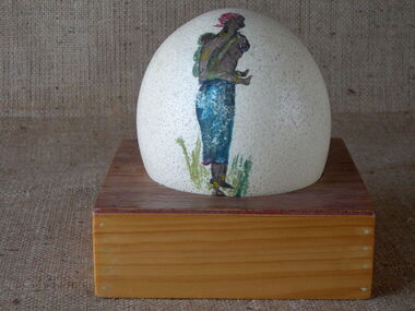
Egg, Painted Ostrich Egg, Early 20th century
... Warrnambool and District Historical Society Inc. 2 Gilles Street (south of Merri St) Warrnambool great-ocean-road Ostrich eggs were a novelty item found in many homes in the 19th and early 20th centuries, though in Australian homes they were more likely to be emu eggs. ...Ostrich eggs were a novelty item found in many homes in the 19th and early 20th centuries, though in Australian homes they were more likely to be emu eggs. Some ostrich eggs may have been brought to Australia from South Africa after the Boer War or purchased by travellers to foreign lands at other times. This ostrich egg has no known provenance.This ostrich egg has been in the collection of the Warrnambool and District Historical Society for 45 years and the only known connection it has to Warrnambool is seen in the fact that the donor was Mrs Uebergang and the Uebergang name is well-known in our district as the Uebergangs were pioneering settlers in the Allansford/ Warrnambool area. This is a cream-coloured ostrich egg resting in a circular cavity in the centre of a rectangular wooden frame. The egg has a small hole on the top and has paintings of an African woman and child on one side of the egg and huts with palm trees on the other side. history of warrnambool, ostrich eggs, painted ostrich egg -
 Kiewa Valley Historical Society
Coloured photographs on paper - Back to Tawonga 2010
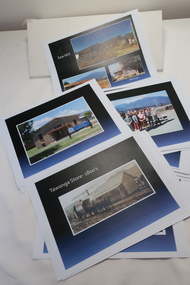
... Emu 27. St Aiden's Debutante Ball 27. Grand Opening Ball 1961 Tawonga Hall 28. The Kiewa Valley Road at Tawonga. ...Emu 27. St Aiden's Debutante Ball 27. Grand Opening Ball 1961 Tawonga Hall 28. The Kiewa Valley Road at Tawonga. ...These photos were collected and copied by Di Edmondson for the 'Back To Tawonga' Event in 2010 when she launched her book "Tawonga Remembers".An historical photographic collection of Tawonga and its surrounds, places and people up to 20101. Saw Mill - Mill house 2. The Rock Pool 3. People at the Rock Pool x 2 4.Old Saw mill 5. Back to Tawonga Celebrations x6 6. Tennis Curts opposite the Tawonga Store, Bakery in the background 7. Bowling Club 8. Old Guide Hall 9. The Old Boarding House 10. Old Fire Brigade Shed 11. Building the New Tawonga Memorial Hall 12. Tawonga Go Kart Track - 1960s 13. Tawonga Pony Club 1969 State Championships 14. Tawonga Recreation Reserve Newspaper article 15. The Damm Children 19. 1980s Brian Edmondson, Geoff Edmondson, Mick Harvey, David Piera. Geoff Edmondson's car 20. Tawonga Speedway Track - 1970s Mick Harvey and Paul Harkin's car 21. 2000 22. Tawonga Sports Vera Ryder and Allie Briggs 23. Tawonga School Photos x8 24. Harry Cooper's Farm Looking South 25.View from Edmondson's Farm - looking north 26. Mount Emu 27. St Aiden's Debutante Ball 27. Grand Opening Ball 1961 Tawonga Hall 28. The Kiewa Valley Road at Tawonga. Vic. 29. Tennis Courts opposite the Bogong Hotel 30.Opening of the new Toilet Block in Pioneer park 31. Old Tawonga Store x 3 32. Tawonga Memorial Hall 33. Anglican Church, St Aiden's x 2 34. Motor Khana held at Recreation reserve 35. 1970 State Champioships Team 36. Kiewa Valley School Sports at Dederang 37. Miscellaneous photos x27 Some photos have headings and some headings have been writtentawonga remembers, back to tawonga 2010, di edmondson -
 Kiewa Valley Historical Society
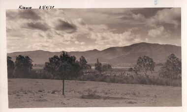
Black and white photograph of farmland, Kiewa, 25/8/38, circa 1938
... Emu in the background. This has been taken from where Mt. Beauty township now stands prior to road making and the erection of houses. ...Beauty and by 1948 street construction in the southern part of the town was completed as far as Hill Street. road construction kiewa tawonga mt. beauty secv Handwritten in black ink on the upper left corner of the photograph is the inscription 'Kiewa 25/8/38' and the number 5 has been stamped on the upper right hand corner. On the back is the word 'Velox' which is the name of the photographic paper on which the photo was developed. A black and white photograph of farmland with Mt. Emu ...This photograph was taken in August, 1938 some eight years prior to the establishment of Mt. Beauty as a township. The area was still being used for grazing, and the land was eventually acquired from the local land owners by the State Electricity Commission. The construction of the road, from Tawonga to the High Plains, was commenced in April of this year. This allowed men and heavy equipment to be transported to the work sites for the construction of the Kiewa Hydro Electric Scheme This photograph is important as it shows the upper Kiewa Valley as it was before the establishment of the town of Mt. Beauty. The land has been cleared of natural growth and has been used for grazing cattle. By 1946 housing construction had commenced for the new town of Mt. Beauty and by 1948 street construction in the southern part of the town was completed as far as Hill Street.A black and white photograph of farmland with Mt. Emu in the background. This has been taken from where Mt. Beauty township now stands prior to road making and the erection of houses. A line of trees below the hill line indicates the position of the East Kiewa River. (No. 5 in a set of 8) Handwritten in black ink on the upper left corner of the photograph is the inscription 'Kiewa 25/8/38' and the number 5 has been stamped on the upper right hand corner. On the back is the word 'Velox' which is the name of the photographic paper on which the photo was developed.road construction, kiewa, tawonga, mt. beauty, secv -
 Orbost & District Historical Society
ledger, 1950's -1960's
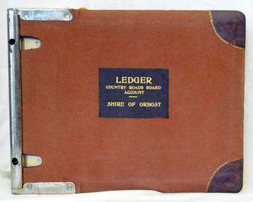
... On the front cover inside a black rectangle in gold print is " LEDGER COUNTRY ROADS BOARD ACCOUNT ORBOST". It is an "Emu Binder"....On the front cover inside a black rectangle in gold print is " LEDGER COUNTRY ROADS BOARD ACCOUNT ORBOST". It is an "Emu Binder". ledger ...This ledger was used bt the Shire of Orbost local government to record Country Roads Board accounts 1950's and 1960's. The item was donated to Orbost & District Historical society from P.R.O.V. as a Place of Deposit (POD) item for safe keeping by a local history group or museum. The shire covered an area of 9,347 square kilometres and existed from 1892 until 1994 when it became part of the East Gippsland Shire Council. Orbost was at first included in the Bairnsdale Shire from 1882 and was later part of the Tambo Shire. Because of travelling distances the Croajingalong Shire was created in 1892 (name changed to Orbost Shire 17.2.1893 with James Cameron as the first Shire President. In 1994 it amalgamated to become part of East Gippsland Shire Council. The Country Roads Board was the government authority for the construction and maintenance of main roads in Victoria between 1913 and 1983. It was succeeded by the Road Construction authority on 1 July 1983 and later merged with the Road Traffic Authority on July 1 1989 to form the Roads Corporation. James Cameron, an Orbost farming pioneer and Member of the Legislative Assembly, fathered the Country Roads Board. This ledger is a hand-written record of accounts for the Orbost Shire local council. It pre-dates computer records. The Orbost Shire Council no longer exists having been absorbed into the East Gippsland Shire Council.A heavy brown coloured ledger with covered wooden covers. it has steel metal binding. Inside are strips of paper marking pages. It contains blue ink hand-written records of monies in/out (?) to Shire of Orbost Council. On the front cover inside a black rectangle in gold print is " LEDGER COUNTRY ROADS BOARD ACCOUNT ORBOST". It is an "Emu Binder".ledger orbost-shire accounts country-roads-board -
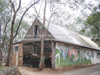 Eltham District Historical Society Inc
Photograph - Digital Photograph, Marguerite Marshall, Art Gallery at Clifton Pugh's Artists' Colony, Dunmoochin, Barreenong Road, Cottles Bridge, 5 February 2008
... Road, Pugh was surrounded by the Australian bush he loved, and where his ashes were later scattered. The 200 acres (81ha) of bushland, broken by glimpses of rolling hills, has more than 50 species of orchids and Pugh shared his property with native animals including kangaroos, emus, phascogales, wombats, and diverse bird life. ...Road, Pugh was surrounded by the Australian bush he loved, and where his ashes were later scattered. The 200 acres (81ha) of bushland, broken by glimpses of rolling hills, has more than 50 species of orchids and Pugh shared his property with native animals including kangaroos, emus, phascogales, wombats, and diverse bird life. ...Art Gallery with mural painted by Clifton Pugh (1924-1990) at his Artists' Colony, Dunmoochin, Barreenong Road, Cottles Bridge. Following military service in the second world war, Clifton Pugh studied under artist Sir William Dargie at the National Gallery School in Melbourne as well as Justus Jorgensen, founder of Montsalvat. For a while he lived on the dole but also worked packing eggs for the Belot family saving sufficient to purchase six acres (2.4 ha) of land at Barreenong Road, Cottles Bridge. He accumulated more land and persuaded several other artists and friends to buy land nearby, resulting in a property of approximately 200 acres, stablishing it as one of the first artistic communes in Australia alongside Montsalvat in Eltham. It was around 1951 that Pugh felt he had '"done moochin' around" and so the name of the property evolved. He bought timber from Alistair Knox to build his house on the crest of a hill. Inspired by local goldminer's huts, it was a one room wattle-and-daub structure with dirt floor. Over the years it expanded with thick adobe walls made from local clay, high ceilings and stone floors. All materials other than the local earth were sourced from second hand materials, most found at wreckers' yards. Artists from across the nation were drawn to Dunmoochin, with several setting up houses and shacks on the property, maintaining their independence but sharing their artistic zeal. Artists who worked or resided at Dunmoochin included Mirka Mora, John Perceval, Albert Tucker, Fred Williams, Charles Blackman, Arthur Boyd and John Olsen. In 2002, Pugh's house along with its treasure trove of art and a library of some 20,000 books was destroyed by fire. Traces of Pugh's home remain with the presence of the Victorian doorframe archway with leadlight of intricate design, procured from a demolished Melbourne mansion; and two bronze life-sized female statues created by Pugh and cast by Matcham Skipper. In place of Pugh's house rose two double-storey mud-brick artists' studios topped with corrugated iron rooves curved like the wings of a bird with accommodation for seven. The original studios, gallery and other buildings survived the fire. Covered under Heritage Overlay, Nillumbik Planning Scheme. Published: Nillumbik Now and Then / Marguerite Marshall 2008; photographs Alan King with Marguerite Marshall.; p153 It’s not surprising that artist Clifton Pugh was drawn to Cottles Bridge to establish his artists’ colony Dunmoochin. Undisturbed by the clamour of modern life at Barreenong Road, Pugh was surrounded by the Australian bush he loved, and where his ashes were later scattered. The 200 acres (81ha) of bushland, broken by glimpses of rolling hills, has more than 50 species of orchids and Pugh shared his property with native animals including kangaroos, emus, phascogales, wombats, and diverse bird life. Pugh encouraged these creatures to join him in the bush by creating, with Monash University, a holding station where the animals were raised. Dunmoochin inspired Pugh for such paintings as in a book on orchids and the Death of a Wombat series.1 But his love for the bush was accompanied by the fear that Europeans were destroying it and much of his painting illustrated this fear and his plea for its conservation.2 However it was his house rather than the surrounding bush that was to be destroyed. Tragically in 2002 Pugh’s house, with its treasure of art and library of 20,000 art books, was destroyed by fire. Traces of the beauty of Pugh’s home still remain, however, in the magnificent Victorian doorframe archway with leadlight of intricate design procured from a demolished Melbourne mansion; and two bronze life-sized female statues created by Pugh and cast by Matcham Skipper. Now in place of Pugh’s house, are two double-storey mud-brick artists’ studios topped with corrugated roofs curved like birds’ wings, with accommodation for seven. The original studios, gallery and other buildings remain.3 Pugh grew up on his parents’ hobby farm at Briar Hill and attended the Briar Hill Primary School, then Eltham High School and later Ivanhoe Grammar. At 15 he became a copy boy for the Radio Times newspaper, then worked as a junior in a drafting office. Pugh was to have three wives and two sons. After serving in World War Two in New Guinea and Japan, Pugh studied under artist Sir William Dargie, at the National Gallery School in Melbourne.4 Another of his teachers was Justus Jörgensen, founder of Montsalvat the Eltham Artists’ Colony. Pugh lived on the dole for a while and paid for his first six acres (2.4ha) at Barreenong Road by working as an egg packer for the Belot family. Pugh accumulated more land and persuaded several other artists and friends to buy land nearby, resulting in the 200 acre property. They, too, purchased their land from the Belot family by working with their chickens. Around 1951 Pugh felt he had ‘Done moochin’ around’ and so the name of his property was born. Pugh bought some used timber from architect Alistair Knox to build his house on the crest of a hill. Inspired by local goldminers’ huts it was a one-room wattle-and-daub structure with a dirt floor. It was so small that the only room he could find for his telephone was on the fork of a tree nearby.5 Over the years the mud-brick house grew to 120 squares in the style now synonymous with Eltham. It had thick adobe walls (sun-dried bricks) made from local clay, high ceilings and stone floors with the entire structure made of second-hand materials – most found at wreckers’ yards. Pugh’s first major show in Melbourne in 1957, established him as a distinctive new painter, breaking away from the European tradition ‘yet not closely allied to any particular school of Australian painting’.6 Pugh became internationally known and was awarded the Order of Australia. He won the Archibald Prize for portraiture three times, although he preferred painting the bush and native animals. In 1990 not long before he died, Pugh was named the Australian War Memorial’s official artist at the 75th anniversary of the landing at Gallipoli. Today one of Pugh’s legacies is the Dunmoochin Foundation, which gives seven individual artists or couples and environmental researchers the chance to work in beautiful and peaceful surroundings, usually for a year. By November 2007, more than 80 people had taken part, and the first disabled artist had been chosen to reside in a new studio with disabled access.1 In 1989, not long before Pugh died in 1990 of a heart attack at age 65, he established the Foundation with La Trobe University and the Victorian Conservation Trust now the Trust for Nature. Pugh’s gift to the Australian people – of around 14 hectares of bushland and buildings and about 550 art works – is run by a voluntary board of directors, headed by one of his sons, Shane Pugh. La Trobe University in Victoria stores and curates the art collection and organises its exhibition around Australia.2 The Foundation aims to protect and foster the natural environment and to provide residences, studios and community art facilities at a minimal cost for artists and environmental researchers. They reside at the non-profit organisation for a year at minimal cost. The buildings, some decorated with murals painted by Pugh and including a gallery, were constructed by Pugh, family and friends, with recycled as well as new materials and mud-bricks. The Foundation is inspired by the tradition begun by the Dunmoochin Artists’ Cooperative which formed in the late 1950s as one of the first artistic communes in Australia. Members bought the land collaboratively and built the seven dwellings so that none could overlook another. But, in the late 1960s, the land was split into private land holdings, which ended the cooperative. Dunmoochin attracted visits from the famous artists of the day including guitarists John Williams and Segovia; singer and comedian Rolf Harris; comedian Barry Humphries; and artists Charles Blackman, Arthur Boyd and Mirka Mora. A potters’ community, started by Peter and Helen Laycock with Alma Shanahan, held monthly exhibitions in the 1960s, attracting local, interstate and international visitors – with up to 500 attending at a time.3 Most artists sold their properties and moved away. But two of the original artists remained into the new millennium as did relative newcomer Heja Chong who built on Pugh’s property (now owned by the Dunmoochin Foundation). In 1984 Chong brought the 1000-year-old Japanese Bizan pottery method to Dunmoochin. She helped build (with potters from all over Australia) the distinctive Bizan-style kiln, which fires pottery from eight to 14 days in pine timber, to produce the Bizan unglazed and simple subdued style. The kiln, which is rare in Australia, is very large with adjoining interconnected ovens of different sizes, providing different temperatures and firing conditions. Frank Werther, who befriended Pugh as a fellow student at the National Gallery Art School in Melbourne, built his house off Barreenong Road in 1954. Werther is a painter of the abstract and colourist style and taught art for about 30 years. Like so many in the post-war years in Eltham Shire, as it was called then, Werther built his home in stages using mud-brick and second-hand materials. The L-shaped house is single-storey but two-storey in parts with a corrugated-iron pitched roof. The waterhole used by the Werthers for their water supply is thought to be a former goldmining shaft.4 Alma Shanahan at Barreenong Road was the first to join Pugh around 1953. They also met at the National Gallery Art School and Shanahan at first visited each weekend to work, mainly making mud-bricks. She shared Pugh’s love for the bush, but when their love affair ended, she designed and built her own house a few hundred yards (metres) away. The mud-brick and timber residence, made in stages with local materials, is rectangular, single-storey with a corrugated-iron roof. As a potter, Shanahan did not originally qualify as an official Cooperative member.This collection of almost 130 photos about places and people within the Shire of Nillumbik, an urban and rural municipality in Melbourne's north, contributes to an understanding of the history of the Shire. Published in 2008 immediately prior to the Black Saturday bushfires of February 7, 2009, it documents sites that were impacted, and in some cases destroyed by the fires. It includes photographs taken especially for the publication, creating a unique time capsule representing the Shire in the early 21st century. It remains the most recent comprehenesive publication devoted to the Shire's history connecting local residents to the past. nillumbik now and then (marshall-king) collection, art gallery, clifton pugh, dunmoochin, cottlesbridge, cottles bridge, barreenong road -
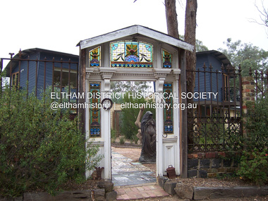 Eltham District Historical Society Inc
Photograph - Digital Photograph, Marguerite Marshall, Doorway of Clifton Pugh's former house at Dunmoochin, Barreenong Road, Cottles Bridge, 5 February 2008
... Road, Pugh was surrounded by the Australian bush he loved, and where his ashes were later scattered. The 200 acres (81ha) of bushland, broken by glimpses of rolling hills, has more than 50 species of orchids and Pugh shared his property with native animals including kangaroos, emus, phascogales, wombats, and diverse bird life. ...Road, Pugh was surrounded by the Australian bush he loved, and where his ashes were later scattered. The 200 acres (81ha) of bushland, broken by glimpses of rolling hills, has more than 50 species of orchids and Pugh shared his property with native animals including kangaroos, emus, phascogales, wombats, and diverse bird life. ...Following military service in the second world war, Clifton Pugh studied under artist Sir William Dargie at the National Gallery School in Melbourne as well as Justus Jorgensen, founder of Montsalvat. For a while he lived on the dole but also worked packing eggs for the Belot family saving sufficient to purchase six acres (2.4 ha) of land at Barreenong Road, Cottles Bridge. He accumulated more land and persuaded several other artists and friends to buy land nearby, resulting in a property of approximately 200 acres, stablishing it as one of the first artistic communes in Australia alongside Montsalvat in Eltham. It was around 1951 that Pugh felt he had '"done moochin' around" and so the name of the property evolved. He bought timber from Alistair Knox to build his house on the crest of a hill. Inspired by local goldminer's huts, it was a one room wattle-and-daub structure with dirt floor. Over the years it expanded with thick adobe walls made from local clay, high ceilings and stone floors. All materials other than the local earth were sourced from second hand materials, most found at wreckers' yards. Artists from across the nation were drawn to Dunmoochin, with several setting up houses and shacks on the property, maintaining their independence but sharing their artistic zeal. Artists who worked or resided at Dunmoochin included Mirka Mora, John Perceval, Albert Tucker, Fred Williams, Charles Blackman, Arthur Boyd and John Olsen. In 2002, Pugh's house along with its treasure trove of art and a library of some 20,000 books was destroyed by fire. Traces of Pugh's home remain with the presence of the Victorian doorframe archway with leadlight of intricate design, procured from a demolished Melbourne mansion; and two bronze life-sized female statues created by Pugh and cast by Matcham Skipper. In place of Pugh's house rose two double-storey mud-brick artists' studios topped with corrugated iron rooves curved like the wings of a bird with accommodation for seven. The original studios, gallery and other buildings survived the fire. Covered under Heritage Overlay, Nillumbik Planning Scheme. Published: Nillumbik Now and Then / Marguerite Marshall 2008; photographs Alan King with Marguerite Marshall.; p155 It’s not surprising that artist Clifton Pugh was drawn to Cottles Bridge to establish his artists’ colony Dunmoochin. Undisturbed by the clamour of modern life at Barreenong Road, Pugh was surrounded by the Australian bush he loved, and where his ashes were later scattered. The 200 acres (81ha) of bushland, broken by glimpses of rolling hills, has more than 50 species of orchids and Pugh shared his property with native animals including kangaroos, emus, phascogales, wombats, and diverse bird life. Pugh encouraged these creatures to join him in the bush by creating, with Monash University, a holding station where the animals were raised. Dunmoochin inspired Pugh for such paintings as in a book on orchids and the Death of a Wombat series.1 But his love for the bush was accompanied by the fear that Europeans were destroying it and much of his painting illustrated this fear and his plea for its conservation.2 However it was his house rather than the surrounding bush that was to be destroyed. Tragically in 2002 Pugh’s house, with its treasure of art and library of 20,000 art books, was destroyed by fire. Traces of the beauty of Pugh’s home still remain, however, in the magnificent Victorian doorframe archway with leadlight of intricate design procured from a demolished Melbourne mansion; and two bronze life-sized female statues created by Pugh and cast by Matcham Skipper. Now in place of Pugh’s house, are two double-storey mud-brick artists’ studios topped with corrugated roofs curved like birds’ wings, with accommodation for seven. The original studios, gallery and other buildings remain.3 Pugh grew up on his parents’ hobby farm at Briar Hill and attended the Briar Hill Primary School, then Eltham High School and later Ivanhoe Grammar. At 15 he became a copy boy for the Radio Times newspaper, then worked as a junior in a drafting office. Pugh was to have three wives and two sons. After serving in World War Two in New Guinea and Japan, Pugh studied under artist Sir William Dargie, at the National Gallery School in Melbourne.4 Another of his teachers was Justus Jörgensen, founder of Montsalvat the Eltham Artists’ Colony. Pugh lived on the dole for a while and paid for his first six acres (2.4ha) at Barreenong Road by working as an egg packer for the Belot family. Pugh accumulated more land and persuaded several other artists and friends to buy land nearby, resulting in the 200 acre property. They, too, purchased their land from the Belot family by working with their chickens. Around 1951 Pugh felt he had ‘Done moochin’ around’ and so the name of his property was born. Pugh bought some used timber from architect Alistair Knox to build his house on the crest of a hill. Inspired by local goldminers’ huts it was a one-room wattle-and-daub structure with a dirt floor. It was so small that the only room he could find for his telephone was on the fork of a tree nearby.5 Over the years the mud-brick house grew to 120 squares in the style now synonymous with Eltham. It had thick adobe walls (sun-dried bricks) made from local clay, high ceilings and stone floors with the entire structure made of second-hand materials – most found at wreckers’ yards. Pugh’s first major show in Melbourne in 1957, established him as a distinctive new painter, breaking away from the European tradition ‘yet not closely allied to any particular school of Australian painting’.6 Pugh became internationally known and was awarded the Order of Australia. He won the Archibald Prize for portraiture three times, although he preferred painting the bush and native animals. In 1990 not long before he died, Pugh was named the Australian War Memorial’s official artist at the 75th anniversary of the landing at Gallipoli. Today one of Pugh’s legacies is the Dunmoochin Foundation, which gives seven individual artists or couples and environmental researchers the chance to work in beautiful and peaceful surroundings, usually for a year. By November 2007, more than 80 people had taken part, and the first disabled artist had been chosen to reside in a new studio with disabled access.1 In 1989, not long before Pugh died in 1990 of a heart attack at age 65, he established the Foundation with La Trobe University and the Victorian Conservation Trust now the Trust for Nature. Pugh’s gift to the Australian people – of around 14 hectares of bushland and buildings and about 550 art works – is run by a voluntary board of directors, headed by one of his sons, Shane Pugh. La Trobe University in Victoria stores and curates the art collection and organises its exhibition around Australia.2 The Foundation aims to protect and foster the natural environment and to provide residences, studios and community art facilities at a minimal cost for artists and environmental researchers. They reside at the non-profit organisation for a year at minimal cost. The buildings, some decorated with murals painted by Pugh and including a gallery, were constructed by Pugh, family and friends, with recycled as well as new materials and mud-bricks. The Foundation is inspired by the tradition begun by the Dunmoochin Artists’ Cooperative which formed in the late 1950s as one of the first artistic communes in Australia. Members bought the land collaboratively and built the seven dwellings so that none could overlook another. But, in the late 1960s, the land was split into private land holdings, which ended the cooperative. Dunmoochin attracted visits from the famous artists of the day including guitarists John Williams and Segovia; singer and comedian Rolf Harris; comedian Barry Humphries; and artists Charles Blackman, Arthur Boyd and Mirka Mora. A potters’ community, started by Peter and Helen Laycock with Alma Shanahan, held monthly exhibitions in the 1960s, attracting local, interstate and international visitors – with up to 500 attending at a time.3 Most artists sold their properties and moved away. But two of the original artists remained into the new millennium as did relative newcomer Heja Chong who built on Pugh’s property (now owned by the Dunmoochin Foundation). In 1984 Chong brought the 1000-year-old Japanese Bizan pottery method to Dunmoochin. She helped build (with potters from all over Australia) the distinctive Bizan-style kiln, which fires pottery from eight to 14 days in pine timber, to produce the Bizan unglazed and simple subdued style. The kiln, which is rare in Australia, is very large with adjoining interconnected ovens of different sizes, providing different temperatures and firing conditions. Frank Werther, who befriended Pugh as a fellow student at the National Gallery Art School in Melbourne, built his house off Barreenong Road in 1954. Werther is a painter of the abstract and colourist style and taught art for about 30 years. Like so many in the post-war years in Eltham Shire, as it was called then, Werther built his home in stages using mud-brick and second-hand materials. The L-shaped house is single-storey but two-storey in parts with a corrugated-iron pitched roof. The waterhole used by the Werthers for their water supply is thought to be a former goldmining shaft.4 Alma Shanahan at Barreenong Road was the first to join Pugh around 1953. They also met at the National Gallery Art School and Shanahan at first visited each weekend to work, mainly making mud-bricks. She shared Pugh’s love for the bush, but when their love affair ended, she designed and built her own house a few hundred yards (metres) away. The mud-brick and timber residence, made in stages with local materials, is rectangular, single-storey with a corrugated-iron roof. As a potter, Shanahan did not originally qualify as an official Cooperative member.This collection of almost 130 photos about places and people within the Shire of Nillumbik, an urban and rural municipality in Melbourne's north, contributes to an understanding of the history of the Shire. Published in 2008 immediately prior to the Black Saturday bushfires of February 7, 2009, it documents sites that were impacted, and in some cases destroyed by the fires. It includes photographs taken especially for the publication, creating a unique time capsule representing the Shire in the early 21st century. It remains the most recent comprehenesive publication devoted to the Shire's history connecting local residents to the past. nillumbik now and then (marshall-king) collection, art gallery, clifton pugh, dunmoochin, cottlesbridge, cottles bridge, barreenong road -
 Bendigo Historical Society Inc.
Photograph - EMU CREEK STATE SCHOOL, 1900's
... Inscriptions: Hand written on back 'Emu Creek State School', 'From Mrs Lowndes, McIvor Road'....Inscriptions: Hand written on back 'Emu Creek State School', 'From Mrs Lowndes, McIvor Road'. Photograph EMU CREEK STATE SCHOOL ...Black and white of school house (and perhaps residence adjoining). School pupils, babies, Adult males and females. Flag pole with Union Jack. Mounted on cream board. Inscriptions: Hand written on back 'Emu Creek State School', 'From Mrs Lowndes, McIvor Road'.WH Robinson Bendigoperson, group, emu creek state school pupils -
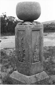 Halls Gap & Grampians Historical Society
Photograph - B/W, 1866
... Halls Gap & Grampians Historical Society Centennial Hall 117-119 Grampians Road Halls Gap grampians Watkins created his sculpture for an exhibition in Melbourne 1866: "I dressed the pillar about 2 foot 6 inches high and 16 inches square and proceeded to carve in each panel representation characteristic of Victoria 1st Panel a Kangaroo in a small scrub thicket, 2nd an Emu amongst a clump of little flowering correa; 3rd the Wimmera Down and on the 4th side my name and the date AD 1866 On the top of the pillar was an urn of globular form to represent the seed pod of the Eucalypti with spreading leaves underneath" Extract taken from 'Victoria's Wonderland' a Grampians history Monument now in private hands QUARRYING Mt Difficult Quarry Heatherlie Quarry; Obelisk : Photo shows stone monument created by Francis Watkins using materials from quarry Photo shows two sided view of monument with large stone on top Photograph B/W ...Watkins created his sculpture for an exhibition in Melbourne 1866: "I dressed the pillar about 2 foot 6 inches high and 16 inches square and proceeded to carve in each panel representation characteristic of Victoria 1st Panel a Kangaroo in a small scrub thicket, 2nd an Emu amongst a clump of little flowering correa; 3rd the Wimmera Down and on the 4th side my name and the date AD 1866 On the top of the pillar was an urn of globular form to represent the seed pod of the Eucalypti with spreading leaves underneath" Extract taken from 'Victoria's Wonderland' a Grampians history Monument now in private handsHeatherlie Quarry; Obelisk : Photo shows stone monument created by Francis Watkins using materials from quarry Photo shows two sided view of monument with large stone on topquarrying, mt difficult quarry -
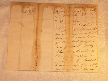 Mortlake and District Historical Society
Letter for payment of account Mortlake Mill, March 7 1864
... road This letter was sent by a customer D. Menzies at Skipton to the Mortlake Mill, detailing an unusual payment method for the processing of his wheat into flour. David Menzies was a Scots farmer who lived in Skipton c. 1860's on a bend in the Mount Emu Creek. ...This letter was sent by a customer D. Menzies at Skipton to the Mortlake Mill, detailing an unusual payment method for the processing of his wheat into flour. David Menzies was a Scots farmer who lived in Skipton c. 1860's on a bend in the Mount Emu Creek. He helped establish the local school and a lane in the township bears his name. The letter illustrates the nature of commerce and the difficulties of communication and life generally in the country at the time. The bluestone Mortlake Mill built in 1856, has been a prominent landmark in Mortlake for over 150 years. It played a significant role in the commercial life of the town and was initially a wind-mill to process district grain for sale. The goldrush at Ararat 100 km. away led to a temporarily increased population and demand for foodstuffs. In 1857 the Mill was sold to Aikman, Hamilton and Geddes who converted it to steampower and later built the prominent chimney, which is on the Heritage Register as part of the National Estate. D. Menzies at Skipton lived at least 85 km away - his wheat which urgently needed milling, faced a slow and arduous journey by bullock dray. After the demise of the Ararat goldfields and the decline in population (as well as the district soils proving unsuitable for sustained wheat cultivation), the operation of the Mill declined too and the proprietors increased their involvement in other activities - supply of building materials, timber felling and sawmills. Despite the apparent difficulties of conducting business in the 1850's, it is notable that commerce thrived at that time in country districts, as an examination of Mill accounts and records show.Handwritten letter dated 1864 (water-stained)Skipton March 7 1864 [to] Messrs. Hamilton & Co. Mortlake. Dear Gentlemen, I was in hope of hearing from you before now that you had commenced working the Mill, & that I could have sent you the enclosed money [for a] load of wheat for Gristing. Please receive the enclosed 2 halves of 2 [two] 5 [pound sign] notes forwarded to your account. the other halves will be sent on receipt of your stating you having received those notes sent. As I am out of flour be so good as say how soon I may send a load of wheat. In haste I am Gentlemen Yours truly D. Menziesmortlake mill grain wheat hamilton geddes aikman laang dixie menzies skipton -
 Eltham District Historical Society Inc
Photograph, Hume and Hovell passed here at Seymour 28 Oct 1824, Spring Excursion, Hume and Hovell's 1824 expedition (Part 2), 26 October 1997, 26/10/1997
... We also deviated down Hume and Hovell Road viewing deer and emu farming and the Bellbourie property now a sanctuary. ...We also deviated down Hume and Hovell Road viewing deer and emu farming and the Bellbourie property now a sanctuary. ...[article by Diana Bassett-Smith in EDHS Newsletter No. 117, November 1997:] MONUMENT HUNTING THE HUME AND HOVELL WAY - Sunday October 26 1997 dawned bright and very warm. Some twenty-five members, complete with picnic baskets, met outside the Eltham Library awaiting the Cobb and Co. large coach which would be taking us on the second leg of our travels along the route of the early explorers Hume and Hovell. Stephen West was our very good driver for the day. He would be guided around the circuitous route by Russell Yeoman who had made a detailed study, not only of the intended route, but of the story of these two explorers. During the trip Russell regaled us with poetry, quotations from the Journals and the History of the Shire of Seymour, "The New Crossing Place" by Martindale, 1982, (now Mitchell Shire due to the recent amalgamations). We headed towards the Hume Highway via Greensborough and Cooper Street and proceeded north to our first stop, noting on the way Monument Hill in the distance which is near Kilmore and, according to Russell, well worth the effort to visit as the view across the valley is magnificent. Past Sunday Creek Valley, Mt Piper and Mt Disappointment, all traversed and noted and named by them. We passed through Tallarook, then onto Seymour where we took photos of the monument telling us that Hume and Hovell had passed through on the 28th of October 1824. We also deviated down Hume and Hovell Road viewing deer and emu farming and the Bellbourie property now a sanctuary. Leaving Seymour behind we travelled up the Avenel Road to the Avenel monument, pyramidal in design of four reducing square blocks with a sharply pointed peak, erected in 1924 in memory of the 1824 exploration. The day was warming up and the countryside showing the dryness of the current drought. A parallel note had been made in their journal too of 1824 of the drought appearance of the country they were traversing. At Seven Creeks, Euroa we stopped for some minutes to check the monument placed 20th November 1924 to commemorate their passage on the 29th December 1824. More photos. Russell had pointed out the abrupt termination of the distant ranges which is noted in their journal. The next monument is beside the road at the entrance to Honey Suckle Creek Caravan Park, Violet Town. The squarish shaped monument some eight feet high is topped with a simple steel cross, and was to mark the date of 28th December 1824 and built for the 20th November 1924. By now it was 12.20 and nearly lunchtime as we drove along the Warranbayne Road to Roach's Road, monument hunting without success. Though there is a large, what appears to be an old timber sign which was hard to read, maybe this was the lost monument. In many of the paddocks hay had been cut and baled or was being cut, what a contrast to the rugged country they had passed through which was smoky from the fires of the natives burning off. By 1.00 pm we were at Benalla and pulled up beside the park where abundant beds of roses filled the air with their scent and the smell of barbecued food twitched the nostrils whilst the cheerful sounds of other picnickers could be heard throughout the park. We left the bus and collected up our picnics, dispersed to the various tables and enjoyed the shade from the various European trees. 2.00 pm and we were on the road again driving along the Benalla, Mansfield, Yea road. The Swanpool monument states that they passed four miles south and returned three miles north. Then we stopped at the Barjarg monument which notes that they camped near this spot. It is again a pyramidal monument and this time topped with a steel arrow indicating their route of the 29th November 1824. Half an hour later we came to another monument, again with a steel arrow marker on top and the plaque dated the 2nd of 12th 1824. Erected on the 12th of 12th 1924. "They blazed the way that we might inherit the land." Another square based and needle topped monument appeared at Yarck near Yea and this plaque records the date of 3 December 1824. Near McGuigans Road Russell related that the expedition had lost a dog but it had found them next day, the dog was apparently torn by a kangaroo. A short while later Russell reminded us here of the problems they encountered in crossing the Goulburn River near Molesworth where banks were high, water deep and wide. "Good coat of grass but quite dry due to drought". At Yea we stopped for afternoon tea and raided the last of our picnics and looked at the monument to their journey of 1824, situated at a corner of the gardens near the bowling green. No photo – we were out of film. We returned home via Kinglake West and Whittlesea past the Yan Yean Reservoir, not full. 5.00 pm back at Eltham we emptied out of the bus and everyone, including Joan Cole, collected their things, Joan also had the major souvenir of the day, a large carp she had picked up from the river bank, her cat was in for a great feast. The day was made so interesting by the informed commentary which Russell provided. His background knowledge of the route and nature of the journey could only have come from many hours of reading and driving the area. Thank you to Russell and to everyone who made the day so informative and pleasurable. Colour photographactivities, hume and hovell, monument, seymour -
 Eltham District Historical Society Inc
Photograph, Spring Excursion, Hume and Hovell's 1824 expedition (Part 2), 26 October 1997, 26/10/1997
... We also deviated down Hume and Hovell Road viewing deer and emu farming and the Bellbourie property now a sanctuary. ...We also deviated down Hume and Hovell Road viewing deer and emu farming and the Bellbourie property now a sanctuary. ...[article by Diana Bassett-Smith in EDHS Newsletter No. 117, November 1997:] MONUMENT HUNTING THE HUME AND HOVELL WAY - Sunday October 26 1997 dawned bright and very warm. Some twenty-five members, complete with picnic baskets, met outside the Eltham Library awaiting the Cobb and Co. large coach which would be taking us on the second leg of our travels along the route of the early explorers Hume and Hovell. Stephen West was our very good driver for the day. He would be guided around the circuitous route by Russell Yeoman who had made a detailed study, not only of the intended route, but of the story of these two explorers. During the trip Russell regaled us with poetry, quotations from the Journals and the History of the Shire of Seymour, "The New Crossing Place" by Martindale, 1982, (now Mitchell Shire due to the recent amalgamations). We headed towards the Hume Highway via Greensborough and Cooper Street and proceeded north to our first stop, noting on the way Monument Hill in the distance which is near Kilmore and, according to Russell, well worth the effort to visit as the view across the valley is magnificent. Past Sunday Creek Valley, Mt Piper and Mt Disappointment, all traversed and noted and named by them. We passed through Tallarook, then onto Seymour where we took photos of the monument telling us that Hume and Hovell had passed through on the 28th of October 1824. We also deviated down Hume and Hovell Road viewing deer and emu farming and the Bellbourie property now a sanctuary. Leaving Seymour behind we travelled up the Avenel Road to the Avenel monument, pyramidal in design of four reducing square blocks with a sharply pointed peak, erected in 1924 in memory of the 1824 exploration. The day was warming up and the countryside showing the dryness of the current drought. A parallel note had been made in their journal too of 1824 of the drought appearance of the country they were traversing. At Seven Creeks, Euroa we stopped for some minutes to check the monument placed 20th November 1924 to commemorate their passage on the 29th December 1824. More photos. Russell had pointed out the abrupt termination of the distant ranges which is noted in their journal. The next monument is beside the road at the entrance to Honey Suckle Creek Caravan Park, Violet Town. The squarish shaped monument some eight feet high is topped with a simple steel cross, and was to mark the date of 28th December 1824 and built for the 20th November 1924. By now it was 12.20 and nearly lunchtime as we drove along the Warranbayne Road to Roach's Road, monument hunting without success. Though there is a large, what appears to be an old timber sign which was hard to read, maybe this was the lost monument. In many of the paddocks hay had been cut and baled or was being cut, what a contrast to the rugged country they had passed through which was smoky from the fires of the natives burning off. By 1.00 pm we were at Benalla and pulled up beside the park where abundant beds of roses filled the air with their scent and the smell of barbecued food twitched the nostrils whilst the cheerful sounds of other picnickers could be heard throughout the park. We left the bus and collected up our picnics, dispersed to the various tables and enjoyed the shade from the various European trees. 2.00 pm and we were on the road again driving along the Benalla, Mansfield, Yea road. The Swanpool monument states that they passed four miles south and returned three miles north. Then we stopped at the Barjarg monument which notes that they camped near this spot. It is again a pyramidal monument and this time topped with a steel arrow indicating their route of the 29th November 1824. Half an hour later we came to another monument, again with a steel arrow marker on top and the plaque dated the 2nd of 12th 1824. Erected on the 12th of 12th 1924. "They blazed the way that we might inherit the land." Another square based and needle topped monument appeared at Yarck near Yea and this plaque records the date of 3 December 1824. Near McGuigans Road Russell related that the expedition had lost a dog but it had found them next day, the dog was apparently torn by a kangaroo. A short while later Russell reminded us here of the problems they encountered in crossing the Goulburn River near Molesworth where banks were high, water deep and wide. "Good coat of grass but quite dry due to drought". At Yea we stopped for afternoon tea and raided the last of our picnics and looked at the monument to their journey of 1824, situated at a corner of the gardens near the bowling green. No photo – we were out of film. We returned home via Kinglake West and Whittlesea past the Yan Yean Reservoir, not full. 5.00 pm back at Eltham we emptied out of the bus and everyone, including Joan Cole, collected their things, Joan also had the major souvenir of the day, a large carp she had picked up from the river bank, her cat was in for a great feast. The day was made so interesting by the informed commentary which Russell provided. His background knowledge of the route and nature of the journey could only have come from many hours of reading and driving the area. Thank you to Russell and to everyone who made the day so informative and pleasurable. Colour photographactivities, hume and hovell, bridge -
 Eltham District Historical Society Inc
Photograph, Spring Excursion, Hume and Hovell bus tour Stage 2, Seymour, Benalla; 26 Oct 1997, 26/10/1997
... We also deviated down Hume and Hovell Road viewing deer and emu farming and the Bellbourie property now a sanctuary. ...We also deviated down Hume and Hovell Road viewing deer and emu farming and the Bellbourie property now a sanctuary. ...MONUMENT HUNTING THE HUME AND HOVELL WAY (Newsletter No. 117, November 1997, by Diana Bassett-Smith) Sunday October 26 1997 dawned bright and very warm. Some twenty-five members, complete with picnic baskets, met outside the Eltham Library awaiting the Cobb and Co. large coach which would be taking us on the second leg of our travels along the route of the early explorers Hume and Hovell. Stephen West was our very good driver for the day. He would be guided around the circuitous route by Russell Yeoman wh9 had made a detailed study, not only of the intended route, but of the story of these two explorers. During the trip Russell regaled us with poetry, quotations from the Journals and the History of the Shire of Seymour, "The New Crossing Place: by Martindale, 1982, (now Mitchell Shire due to the recent amalgamations). We headed towards the Hume Highway via Greensborough and Cooper Street and proceeded north to our first stop, noting on the way Monument Hill in the distance which is near Kilmore and, according to Russell, well worth the effort to visit as the view across the valley is magnificent. Past Sunday Creek Valley, Mt Piper and Mt Disappointment, all traversed and noted and named by them. We passed through Tallarook, then onto Seymour where we took photos of the monument telling us that Hume and Hovell had passed through on the 28th of October 1824. We also deviated down Hume and Hovell Road viewing deer and emu farming and the Bellbourie property now a sanctuary. Leaving Seymour behind we travelled up the Avenel Road to the Avenel monument, pyramidal in design of four reducing square blocks with a sharply pointed peak, erected in 1924 in memory of the 1824 exploration. The day was warming up and the countryside showing the dryness of the current drought. A parallel note had been made in their journal too of 1824 of the drought appearance of the country they were traversing. At Seven Creeks, Euroa we stopped for some minutes to check the monument placed 20th November 1924 to commemorate their passage on the 29th December 1824. More photos. Russell had pointed out the abrupt termination of the distant ranges which is noted in their journal. The next monument is beside the road at the entrance to Honey Suckle Creek Caravan Park, Violet Town. The squarish shaped monument some eight feet high is topped with a simple steel cross, and was to mark the date of 28th December 1824 and built for the 20th November 1924. By now it was 12.20 and nearly lunchtime as we drove along the Warranbayne Road to Roach's Road, monument hunting without success. Though there is a large, what appears to be an old timber sign which was hard to read, maybe this was the lost monument. In many of the paddocks hay had been cut and baled or was being cut, what a contrast to the rugged country they had passed through which was smoky from the fires of the natives burning off By 1.00 pm we were at Benalla and pulled up beside the park where abundant beds of roses filled the air with their scent and the smell of barbecued food twitched the nostrils whilst the cheerful sounds of other picnickers could be heard throughout the park. We left the bus and collected up our picnics, dispersed to the various tables and enjoyed the shade from the various European trees. 2.00 pm and we were on the road again driving along the Benalla, Mansfield, Yea road. The Swanpool monument states that they passed four miles south and returned three miles north. Then we stopped at the Barjarg monument which notes that they camped near this spot. It is again a pyramidal monument and this time topped with a steel arrow indicating their route of the 29th November 1824. Half an hour later we came to another monument, again with a steel arrow marker on top and the plaque dated the 2nd of 12th 1824. Erected on the 12th of 12th 1924. "They blazed the way that we might inherit the land." Another square based and needle topped monument appeared at Yarck near Yea and this plaque records the date of 3 December 1824. Near McGuigans Road Russell related that the expedition had lost a dog but it had found them next day, the dog was apparently torn by a kangaroo. A short while later Russell reminded us here of the problems they encountered in crossing the Goulburn River near Molesworth where banks were high, water deep and wide. "Good coat of grass but quite dry due to drought". At Yea we stopped for afternoon tea and raided the last of our picnics and looked at the monument to their journey of 1824, situated at a corner of the gardens near the bowling green. No photo – we were out of film. We returned home via Kinglake West and Whittlesea past the Yan Yean Reservoir, not full. 5.00 pm back at Eltham we emptied out of the bus and everyone, including Joan Cole, collected their things, Joan also had the major souvenir of the day, a large carp she had picked up from the river bank, her cat was in for a great feast. The day was made so interesting by the informed commentary which Russell provided. His background knowledge of the route and nature of the journey could only have come from many hours of reading and driving the area. Thank you to Russell and to everyone who made the day so informative and pleasurable. Diana Bassett-Smith. Record of the Society's history of activities - Spring 1997 excursionRoll of 35mm colour negative film, 6 stripsFuji 200shire of eltham historical society, activities, pretty hill, seymour, benalla, hume and hovell, monuments -
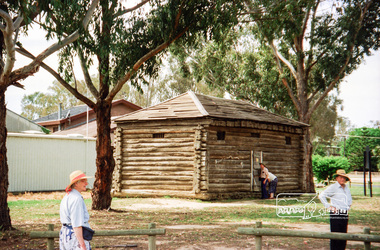 Eltham District Historical Society Inc
Photograph, Spring Excursion, Hume and Hovell bus tour Stage 2, Seymour, Benalla; 26 Oct 1997, 26/10/1997
... We also deviated down Hume and Hovell Road viewing deer and emu farming and the Bellbourie property now a sanctuary. ...We also deviated down Hume and Hovell Road viewing deer and emu farming and the Bellbourie property now a sanctuary. ...MONUMENT HUNTING THE HUME AND HOVELL WAY (Newsletter No. 117, November 1997, by Diana Bassett-Smith) Sunday October 26 1997 dawned bright and very warm. Some twenty-five members, complete with picnic baskets, met outside the Eltham Library awaiting the Cobb and Co. large coach which would be taking us on the second leg of our travels along the route of the early explorers Hume and Hovell. Stephen West was our very good driver for the day. He would be guided around the circuitous route by Russell Yeoman wh9 had made a detailed study, not only of the intended route, but of the story of these two explorers. During the trip Russell regaled us with poetry, quotations from the Journals and the History of the Shire of Seymour, "The New Crossing Place: by Martindale, 1982, (now Mitchell Shire due to the recent amalgamations). We headed towards the Hume Highway via Greensborough and Cooper Street and proceeded north to our first stop, noting on the way Monument Hill in the distance which is near Kilmore and, according to Russell, well worth the effort to visit as the view across the valley is magnificent. Past Sunday Creek Valley, Mt Piper and Mt Disappointment, all traversed and noted and named by them. We passed through Tallarook, then onto Seymour where we took photos of the monument telling us that Hume and Hovell had passed through on the 28th of October 1824. We also deviated down Hume and Hovell Road viewing deer and emu farming and the Bellbourie property now a sanctuary. Leaving Seymour behind we travelled up the Avenel Road to the Avenel monument, pyramidal in design of four reducing square blocks with a sharply pointed peak, erected in 1924 in memory of the 1824 exploration. The day was warming up and the countryside showing the dryness of the current drought. A parallel note had been made in their journal too of 1824 of the drought appearance of the country they were traversing. At Seven Creeks, Euroa we stopped for some minutes to check the monument placed 20th November 1924 to commemorate their passage on the 29th December 1824. More photos. Russell had pointed out the abrupt termination of the distant ranges which is noted in their journal. The next monument is beside the road at the entrance to Honey Suckle Creek Caravan Park, Violet Town. The squarish shaped monument some eight feet high is topped with a simple steel cross, and was to mark the date of 28th December 1824 and built for the 20th November 1924. By now it was 12.20 and nearly lunchtime as we drove along the Warranbayne Road to Roach's Road, monument hunting without success. Though there is a large, what appears to be an old timber sign which was hard to read, maybe this was the lost monument. In many of the paddocks hay had been cut and baled or was being cut, what a contrast to the rugged country they had passed through which was smoky from the fires of the natives burning off By 1.00 pm we were at Benalla and pulled up beside the park where abundant beds of roses filled the air with their scent and the smell of barbecued food twitched the nostrils whilst the cheerful sounds of other picnickers could be heard throughout the park. We left the bus and collected up our picnics, dispersed to the various tables and enjoyed the shade from the various European trees. 2.00 pm and we were on the road again driving along the Benalla, Mansfield, Yea road. The Swanpool monument states that they passed four miles south and returned three miles north. Then we stopped at the Barjarg monument which notes that they camped near this spot. It is again a pyramidal monument and this time topped with a steel arrow indicating their route of the 29th November 1824. Half an hour later we came to another monument, again with a steel arrow marker on top and the plaque dated the 2nd of 12th 1824. Erected on the 12th of 12th 1924. "They blazed the way that we might inherit the land." Another square based and needle topped monument appeared at Yarck near Yea and this plaque records the date of 3 December 1824. Near McGuigans Road Russell related that the expedition had lost a dog but it had found them next day, the dog was apparently torn by a kangaroo. A short while later Russell reminded us here of the problems they encountered in crossing the Goulburn River near Molesworth where banks were high, water deep and wide. "Good coat of grass but quite dry due to drought". At Yea we stopped for afternoon tea and raided the last of our picnics and looked at the monument to their journey of 1824, situated at a corner of the gardens near the bowling green. No photo – we were out of film. We returned home via Kinglake West and Whittlesea past the Yan Yean Reservoir, not full. 5.00 pm back at Eltham we emptied out of the bus and everyone, including Joan Cole, collected their things, Joan also had the major souvenir of the day, a large carp she had picked up from the river bank, her cat was in for a great feast. The day was made so interesting by the informed commentary which Russell provided. His background knowledge of the route and nature of the journey could only have come from many hours of reading and driving the area. Thank you to Russell and to everyone who made the day so informative and pleasurable. Diana Bassett-Smith. Record of the Society's history of activities - Spring 1997 excursionRoll of 35mm colour negative film, 2 stripsKodak Gold 400-5shire of eltham historical society, activities, pretty hill, seymour, benalla, hume and hovell, monuments -
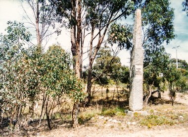 Eltham District Historical Society Inc
Photograph, Hume and Hovell passed here at Seymour 28 Oct 1824, Spring Excursion, Hume and Hovell's 1824 expedition (Part 2), 26 October 1997, 26/10/1997
... We also deviated down Hume and Hovell Road viewing deer and emu farming and the Bellbourie property now a sanctuary. ...We also deviated down Hume and Hovell Road viewing deer and emu farming and the Bellbourie property now a sanctuary. ...[article by Diana Bassett-Smith in EDHS Newsletter No. 117, November 1997:] MONUMENT HUNTING THE HUME AND HOVELL WAY - Sunday October 26 1997 dawned bright and very warm. Some twenty-five members, complete with picnic baskets, met outside the Eltham Library awaiting the Cobb and Co. large coach which would be taking us on the second leg of our travels along the route of the early explorers Hume and Hovell. Stephen West was our very good driver for the day. He would be guided around the circuitous route by Russell Yeoman who had made a detailed study, not only of the intended route, but of the story of these two explorers. During the trip Russell regaled us with poetry, quotations from the Journals and the History of the Shire of Seymour, "The New Crossing Place" by Martindale, 1982, (now Mitchell Shire due to the recent amalgamations). We headed towards the Hume Highway via Greensborough and Cooper Street and proceeded north to our first stop, noting on the way Monument Hill in the distance which is near Kilmore and, according to Russell, well worth the effort to visit as the view across the valley is magnificent. Past Sunday Creek Valley, Mt Piper and Mt Disappointment, all traversed and noted and named by them. We passed through Tallarook, then onto Seymour where we took photos of the monument telling us that Hume and Hovell had passed through on the 28th of October 1824. We also deviated down Hume and Hovell Road viewing deer and emu farming and the Bellbourie property now a sanctuary. Leaving Seymour behind we travelled up the Avenel Road to the Avenel monument, pyramidal in design of four reducing square blocks with a sharply pointed peak, erected in 1924 in memory of the 1824 exploration. The day was warming up and the countryside showing the dryness of the current drought. A parallel note had been made in their journal too of 1824 of the drought appearance of the country they were traversing. At Seven Creeks, Euroa we stopped for some minutes to check the monument placed 20th November 1924 to commemorate their passage on the 29th December 1824. More photos. Russell had pointed out the abrupt termination of the distant ranges which is noted in their journal. The next monument is beside the road at the entrance to Honey Suckle Creek Caravan Park, Violet Town. The squarish shaped monument some eight feet high is topped with a simple steel cross, and was to mark the date of 28th December 1824 and built for the 20th November 1924. By now it was 12.20 and nearly lunchtime as we drove along the Warranbayne Road to Roach's Road, monument hunting without success. Though there is a large, what appears to be an old timber sign which was hard to read, maybe this was the lost monument. In many of the paddocks hay had been cut and baled or was being cut, what a contrast to the rugged country they had passed through which was smoky from the fires of the natives burning off. By 1.00 pm we were at Benalla and pulled up beside the park where abundant beds of roses filled the air with their scent and the smell of barbecued food twitched the nostrils whilst the cheerful sounds of other picnickers could be heard throughout the park. We left the bus and collected up our picnics, dispersed to the various tables and enjoyed the shade from the various European trees. 2.00 pm and we were on the road again driving along the Benalla, Mansfield, Yea road. The Swanpool monument states that they passed four miles south and returned three miles north. Then we stopped at the Barjarg monument which notes that they camped near this spot. It is again a pyramidal monument and this time topped with a steel arrow indicating their route of the 29th November 1824. Half an hour later we came to another monument, again with a steel arrow marker on top and the plaque dated the 2nd of 12th 1824. Erected on the 12th of 12th 1924. "They blazed the way that we might inherit the land." Another square based and needle topped monument appeared at Yarck near Yea and this plaque records the date of 3 December 1824. Near McGuigans Road Russell related that the expedition had lost a dog but it had found them next day, the dog was apparently torn by a kangaroo. A short while later Russell reminded us here of the problems they encountered in crossing the Goulburn River near Molesworth where banks were high, water deep and wide. "Good coat of grass but quite dry due to drought". At Yea we stopped for afternoon tea and raided the last of our picnics and looked at the monument to their journey of 1824, situated at a corner of the gardens near the bowling green. No photo – we were out of film. We returned home via Kinglake West and Whittlesea past the Yan Yean Reservoir, not full. 5.00 pm back at Eltham we emptied out of the bus and everyone, including Joan Cole, collected their things, Joan also had the major souvenir of the day, a large carp she had picked up from the river bank, her cat was in for a great feast. The day was made so interesting by the informed commentary which Russell provided. His background knowledge of the route and nature of the journey could only have come from many hours of reading and driving the area. Thank you to Russell and to everyone who made the day so informative and pleasurable. Colour photographactivities, hume and hovell, monument, seymour -
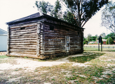 Eltham District Historical Society Inc
Photograph, Gaol at Seymour, Spring Excursion, Hume and Hovell's 1824 expedition (Part 2), 26 October 1997, 26/10/1997
... We also deviated down Hume and Hovell Road viewing deer and emu farming and the Bellbourie property now a sanctuary. ...We also deviated down Hume and Hovell Road viewing deer and emu farming and the Bellbourie property now a sanctuary. ...[article by Diana Bassett-Smith in EDHS Newsletter No. 117, November 1997:] MONUMENT HUNTING THE HUME AND HOVELL WAY - Sunday October 26 1997 dawned bright and very warm. Some twenty-five members, complete with picnic baskets, met outside the Eltham Library awaiting the Cobb and Co. large coach which would be taking us on the second leg of our travels along the route of the early explorers Hume and Hovell. Stephen West was our very good driver for the day. He would be guided around the circuitous route by Russell Yeoman who had made a detailed study, not only of the intended route, but of the story of these two explorers. During the trip Russell regaled us with poetry, quotations from the Journals and the History of the Shire of Seymour, "The New Crossing Place" by Martindale, 1982, (now Mitchell Shire due to the recent amalgamations). We headed towards the Hume Highway via Greensborough and Cooper Street and proceeded north to our first stop, noting on the way Monument Hill in the distance which is near Kilmore and, according to Russell, well worth the effort to visit as the view across the valley is magnificent. Past Sunday Creek Valley, Mt Piper and Mt Disappointment, all traversed and noted and named by them. We passed through Tallarook, then onto Seymour where we took photos of the monument telling us that Hume and Hovell had passed through on the 28th of October 1824. We also deviated down Hume and Hovell Road viewing deer and emu farming and the Bellbourie property now a sanctuary. Leaving Seymour behind we travelled up the Avenel Road to the Avenel monument, pyramidal in design of four reducing square blocks with a sharply pointed peak, erected in 1924 in memory of the 1824 exploration. The day was warming up and the countryside showing the dryness of the current drought. A parallel note had been made in their journal too of 1824 of the drought appearance of the country they were traversing. At Seven Creeks, Euroa we stopped for some minutes to check the monument placed 20th November 1924 to commemorate their passage on the 29th December 1824. More photos. Russell had pointed out the abrupt termination of the distant ranges which is noted in their journal. The next monument is beside the road at the entrance to Honey Suckle Creek Caravan Park, Violet Town. The squarish shaped monument some eight feet high is topped with a simple steel cross, and was to mark the date of 28th December 1824 and built for the 20th November 1924. By now it was 12.20 and nearly lunchtime as we drove along the Warranbayne Road to Roach's Road, monument hunting without success. Though there is a large, what appears to be an old timber sign which was hard to read, maybe this was the lost monument. In many of the paddocks hay had been cut and baled or was being cut, what a contrast to the rugged country they had passed through which was smoky from the fires of the natives burning off. By 1.00 pm we were at Benalla and pulled up beside the park where abundant beds of roses filled the air with their scent and the smell of barbecued food twitched the nostrils whilst the cheerful sounds of other picnickers could be heard throughout the park. We left the bus and collected up our picnics, dispersed to the various tables and enjoyed the shade from the various European trees. 2.00 pm and we were on the road again driving along the Benalla, Mansfield, Yea road. The Swanpool monument states that they passed four miles south and returned three miles north. Then we stopped at the Barjarg monument which notes that they camped near this spot. It is again a pyramidal monument and this time topped with a steel arrow indicating their route of the 29th November 1824. Half an hour later we came to another monument, again with a steel arrow marker on top and the plaque dated the 2nd of 12th 1824. Erected on the 12th of 12th 1924. "They blazed the way that we might inherit the land." Another square based and needle topped monument appeared at Yarck near Yea and this plaque records the date of 3 December 1824. Near McGuigans Road Russell related that the expedition had lost a dog but it had found them next day, the dog was apparently torn by a kangaroo. A short while later Russell reminded us here of the problems they encountered in crossing the Goulburn River near Molesworth where banks were high, water deep and wide. "Good coat of grass but quite dry due to drought". At Yea we stopped for afternoon tea and raided the last of our picnics and looked at the monument to their journey of 1824, situated at a corner of the gardens near the bowling green. No photo – we were out of film. We returned home via Kinglake West and Whittlesea past the Yan Yean Reservoir, not full. 5.00 pm back at Eltham we emptied out of the bus and everyone, including Joan Cole, collected their things, Joan also had the major souvenir of the day, a large carp she had picked up from the river bank, her cat was in for a great feast. The day was made so interesting by the informed commentary which Russell provided. His background knowledge of the route and nature of the journey could only have come from many hours of reading and driving the area. Thank you to Russell and to everyone who made the day so informative and pleasurable. Colour photographactivities, hume and hovell, seymour, gaol -
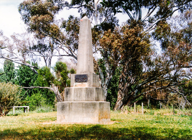 Eltham District Historical Society Inc
Photograph, Hume and Hovell Monument, Avenel, Spring Excursion, Hume and Hovell's 1824 expedition (Part 2), 26 October 1997, 26/10/1997
... We also deviated down Hume and Hovell Road viewing deer and emu farming and the Bellbourie property now a sanctuary. ...We also deviated down Hume and Hovell Road viewing deer and emu farming and the Bellbourie property now a sanctuary. ...[article by Diana Bassett-Smith in EDHS Newsletter No. 117, November 1997:] MONUMENT HUNTING THE HUME AND HOVELL WAY - Sunday October 26 1997 dawned bright and very warm. Some twenty-five members, complete with picnic baskets, met outside the Eltham Library awaiting the Cobb and Co. large coach which would be taking us on the second leg of our travels along the route of the early explorers Hume and Hovell. Stephen West was our very good driver for the day. He would be guided around the circuitous route by Russell Yeoman who had made a detailed study, not only of the intended route, but of the story of these two explorers. During the trip Russell regaled us with poetry, quotations from the Journals and the History of the Shire of Seymour, "The New Crossing Place" by Martindale, 1982, (now Mitchell Shire due to the recent amalgamations). We headed towards the Hume Highway via Greensborough and Cooper Street and proceeded north to our first stop, noting on the way Monument Hill in the distance which is near Kilmore and, according to Russell, well worth the effort to visit as the view across the valley is magnificent. Past Sunday Creek Valley, Mt Piper and Mt Disappointment, all traversed and noted and named by them. We passed through Tallarook, then onto Seymour where we took photos of the monument telling us that Hume and Hovell had passed through on the 28th of October 1824. We also deviated down Hume and Hovell Road viewing deer and emu farming and the Bellbourie property now a sanctuary. Leaving Seymour behind we travelled up the Avenel Road to the Avenel monument, pyramidal in design of four reducing square blocks with a sharply pointed peak, erected in 1924 in memory of the 1824 exploration. The day was warming up and the countryside showing the dryness of the current drought. A parallel note had been made in their journal too of 1824 of the drought appearance of the country they were traversing. At Seven Creeks, Euroa we stopped for some minutes to check the monument placed 20th November 1924 to commemorate their passage on the 29th December 1824. More photos. Russell had pointed out the abrupt termination of the distant ranges which is noted in their journal. The next monument is beside the road at the entrance to Honey Suckle Creek Caravan Park, Violet Town. The squarish shaped monument some eight feet high is topped with a simple steel cross, and was to mark the date of 28th December 1824 and built for the 20th November 1924. By now it was 12.20 and nearly lunchtime as we drove along the Warranbayne Road to Roach's Road, monument hunting without success. Though there is a large, what appears to be an old timber sign which was hard to read, maybe this was the lost monument. In many of the paddocks hay had been cut and baled or was being cut, what a contrast to the rugged country they had passed through which was smoky from the fires of the natives burning off. By 1.00 pm we were at Benalla and pulled up beside the park where abundant beds of roses filled the air with their scent and the smell of barbecued food twitched the nostrils whilst the cheerful sounds of other picnickers could be heard throughout the park. We left the bus and collected up our picnics, dispersed to the various tables and enjoyed the shade from the various European trees. 2.00 pm and we were on the road again driving along the Benalla, Mansfield, Yea road. The Swanpool monument states that they passed four miles south and returned three miles north. Then we stopped at the Barjarg monument which notes that they camped near this spot. It is again a pyramidal monument and this time topped with a steel arrow indicating their route of the 29th November 1824. Half an hour later we came to another monument, again with a steel arrow marker on top and the plaque dated the 2nd of 12th 1824. Erected on the 12th of 12th 1924. "They blazed the way that we might inherit the land." Another square based and needle topped monument appeared at Yarck near Yea and this plaque records the date of 3 December 1824. Near McGuigans Road Russell related that the expedition had lost a dog but it had found them next day, the dog was apparently torn by a kangaroo. A short while later Russell reminded us here of the problems they encountered in crossing the Goulburn River near Molesworth where banks were high, water deep and wide. "Good coat of grass but quite dry due to drought". At Yea we stopped for afternoon tea and raided the last of our picnics and looked at the monument to their journey of 1824, situated at a corner of the gardens near the bowling green. No photo – we were out of film. We returned home via Kinglake West and Whittlesea past the Yan Yean Reservoir, not full. 5.00 pm back at Eltham we emptied out of the bus and everyone, including Joan Cole, collected their things, Joan also had the major souvenir of the day, a large carp she had picked up from the river bank, her cat was in for a great feast. The day was made so interesting by the informed commentary which Russell provided. His background knowledge of the route and nature of the journey could only have come from many hours of reading and driving the area. Thank you to Russell and to everyone who made the day so informative and pleasurable. Colour photographactivities, hume and hovell, avenel, monument -
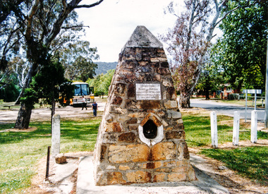 Eltham District Historical Society Inc
Photograph, Hume and Hovell Monument, Seven Creeks, Euroa (29.12.1824), Spring Excursion, Hume and Hovell's 1824 expedition (Part 2), 26 October 1997, 26/10/1997
... We also deviated down Hume and Hovell Road viewing deer and emu farming and the Bellbourie property now a sanctuary. ...We also deviated down Hume and Hovell Road viewing deer and emu farming and the Bellbourie property now a sanctuary. ...[article by Diana Bassett-Smith in EDHS Newsletter No. 117, November 1997:] MONUMENT HUNTING THE HUME AND HOVELL WAY - Sunday October 26 1997 dawned bright and very warm. Some twenty-five members, complete with picnic baskets, met outside the Eltham Library awaiting the Cobb and Co. large coach which would be taking us on the second leg of our travels along the route of the early explorers Hume and Hovell. Stephen West was our very good driver for the day. He would be guided around the circuitous route by Russell Yeoman who had made a detailed study, not only of the intended route, but of the story of these two explorers. During the trip Russell regaled us with poetry, quotations from the Journals and the History of the Shire of Seymour, "The New Crossing Place" by Martindale, 1982, (now Mitchell Shire due to the recent amalgamations). We headed towards the Hume Highway via Greensborough and Cooper Street and proceeded north to our first stop, noting on the way Monument Hill in the distance which is near Kilmore and, according to Russell, well worth the effort to visit as the view across the valley is magnificent. Past Sunday Creek Valley, Mt Piper and Mt Disappointment, all traversed and noted and named by them. We passed through Tallarook, then onto Seymour where we took photos of the monument telling us that Hume and Hovell had passed through on the 28th of October 1824. We also deviated down Hume and Hovell Road viewing deer and emu farming and the Bellbourie property now a sanctuary. Leaving Seymour behind we travelled up the Avenel Road to the Avenel monument, pyramidal in design of four reducing square blocks with a sharply pointed peak, erected in 1924 in memory of the 1824 exploration. The day was warming up and the countryside showing the dryness of the current drought. A parallel note had been made in their journal too of 1824 of the drought appearance of the country they were traversing. At Seven Creeks, Euroa we stopped for some minutes to check the monument placed 20th November 1924 to commemorate their passage on the 29th December 1824. More photos. Russell had pointed out the abrupt termination of the distant ranges which is noted in their journal. The next monument is beside the road at the entrance to Honey Suckle Creek Caravan Park, Violet Town. The squarish shaped monument some eight feet high is topped with a simple steel cross, and was to mark the date of 28th December 1824 and built for the 20th November 1924. By now it was 12.20 and nearly lunchtime as we drove along the Warranbayne Road to Roach's Road, monument hunting without success. Though there is a large, what appears to be an old timber sign which was hard to read, maybe this was the lost monument. In many of the paddocks hay had been cut and baled or was being cut, what a contrast to the rugged country they had passed through which was smoky from the fires of the natives burning off. By 1.00 pm we were at Benalla and pulled up beside the park where abundant beds of roses filled the air with their scent and the smell of barbecued food twitched the nostrils whilst the cheerful sounds of other picnickers could be heard throughout the park. We left the bus and collected up our picnics, dispersed to the various tables and enjoyed the shade from the various European trees. 2.00 pm and we were on the road again driving along the Benalla, Mansfield, Yea road. The Swanpool monument states that they passed four miles south and returned three miles north. Then we stopped at the Barjarg monument which notes that they camped near this spot. It is again a pyramidal monument and this time topped with a steel arrow indicating their route of the 29th November 1824. Half an hour later we came to another monument, again with a steel arrow marker on top and the plaque dated the 2nd of 12th 1824. Erected on the 12th of 12th 1924. "They blazed the way that we might inherit the land." Another square based and needle topped monument appeared at Yarck near Yea and this plaque records the date of 3 December 1824. Near McGuigans Road Russell related that the expedition had lost a dog but it had found them next day, the dog was apparently torn by a kangaroo. A short while later Russell reminded us here of the problems they encountered in crossing the Goulburn River near Molesworth where banks were high, water deep and wide. "Good coat of grass but quite dry due to drought". At Yea we stopped for afternoon tea and raided the last of our picnics and looked at the monument to their journey of 1824, situated at a corner of the gardens near the bowling green. No photo – we were out of film. We returned home via Kinglake West and Whittlesea past the Yan Yean Reservoir, not full. 5.00 pm back at Eltham we emptied out of the bus and everyone, including Joan Cole, collected their things, Joan also had the major souvenir of the day, a large carp she had picked up from the river bank, her cat was in for a great feast. The day was made so interesting by the informed commentary which Russell provided. His background knowledge of the route and nature of the journey could only have come from many hours of reading and driving the area. Thank you to Russell and to everyone who made the day so informative and pleasurable. Colour photographactivities, hume and hovell, monument, euroa, seven creeks -
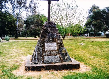 Eltham District Historical Society Inc
Photograph, Hume and Hovell Monument, Honeysuckle Caravan Park, Violet Town (28.12.1824), Spring Excursion, Hume and Hovell's 1824 expedition (Part 2), 26 October 1997, 26/10/1997
... We also deviated down Hume and Hovell Road viewing deer and emu farming and the Bellbourie property now a sanctuary. ...We also deviated down Hume and Hovell Road viewing deer and emu farming and the Bellbourie property now a sanctuary. ...[article by Diana Bassett-Smith in EDHS Newsletter No. 117, November 1997:] MONUMENT HUNTING THE HUME AND HOVELL WAY - Sunday October 26 1997 dawned bright and very warm. Some twenty-five members, complete with picnic baskets, met outside the Eltham Library awaiting the Cobb and Co. large coach which would be taking us on the second leg of our travels along the route of the early explorers Hume and Hovell. Stephen West was our very good driver for the day. He would be guided around the circuitous route by Russell Yeoman who had made a detailed study, not only of the intended route, but of the story of these two explorers. During the trip Russell regaled us with poetry, quotations from the Journals and the History of the Shire of Seymour, "The New Crossing Place" by Martindale, 1982, (now Mitchell Shire due to the recent amalgamations). We headed towards the Hume Highway via Greensborough and Cooper Street and proceeded north to our first stop, noting on the way Monument Hill in the distance which is near Kilmore and, according to Russell, well worth the effort to visit as the view across the valley is magnificent. Past Sunday Creek Valley, Mt Piper and Mt Disappointment, all traversed and noted and named by them. We passed through Tallarook, then onto Seymour where we took photos of the monument telling us that Hume and Hovell had passed through on the 28th of October 1824. We also deviated down Hume and Hovell Road viewing deer and emu farming and the Bellbourie property now a sanctuary. Leaving Seymour behind we travelled up the Avenel Road to the Avenel monument, pyramidal in design of four reducing square blocks with a sharply pointed peak, erected in 1924 in memory of the 1824 exploration. The day was warming up and the countryside showing the dryness of the current drought. A parallel note had been made in their journal too of 1824 of the drought appearance of the country they were traversing. At Seven Creeks, Euroa we stopped for some minutes to check the monument placed 20th November 1924 to commemorate their passage on the 29th December 1824. More photos. Russell had pointed out the abrupt termination of the distant ranges which is noted in their journal. The next monument is beside the road at the entrance to Honey Suckle Creek Caravan Park, Violet Town. The squarish shaped monument some eight feet high is topped with a simple steel cross, and was to mark the date of 28th December 1824 and built for the 20th November 1924. By now it was 12.20 and nearly lunchtime as we drove along the Warranbayne Road to Roach's Road, monument hunting without success. Though there is a large, what appears to be an old timber sign which was hard to read, maybe this was the lost monument. In many of the paddocks hay had been cut and baled or was being cut, what a contrast to the rugged country they had passed through which was smoky from the fires of the natives burning off. By 1.00 pm we were at Benalla and pulled up beside the park where abundant beds of roses filled the air with their scent and the smell of barbecued food twitched the nostrils whilst the cheerful sounds of other picnickers could be heard throughout the park. We left the bus and collected up our picnics, dispersed to the various tables and enjoyed the shade from the various European trees. 2.00 pm and we were on the road again driving along the Benalla, Mansfield, Yea road. The Swanpool monument states that they passed four miles south and returned three miles north. Then we stopped at the Barjarg monument which notes that they camped near this spot. It is again a pyramidal monument and this time topped with a steel arrow indicating their route of the 29th November 1824. Half an hour later we came to another monument, again with a steel arrow marker on top and the plaque dated the 2nd of 12th 1824. Erected on the 12th of 12th 1924. "They blazed the way that we might inherit the land." Another square based and needle topped monument appeared at Yarck near Yea and this plaque records the date of 3 December 1824. Near McGuigans Road Russell related that the expedition had lost a dog but it had found them next day, the dog was apparently torn by a kangaroo. A short while later Russell reminded us here of the problems they encountered in crossing the Goulburn River near Molesworth where banks were high, water deep and wide. "Good coat of grass but quite dry due to drought". At Yea we stopped for afternoon tea and raided the last of our picnics and looked at the monument to their journey of 1824, situated at a corner of the gardens near the bowling green. No photo – we were out of film. We returned home via Kinglake West and Whittlesea past the Yan Yean Reservoir, not full. 5.00 pm back at Eltham we emptied out of the bus and everyone, including Joan Cole, collected their things, Joan also had the major souvenir of the day, a large carp she had picked up from the river bank, her cat was in for a great feast. The day was made so interesting by the informed commentary which Russell provided. His background knowledge of the route and nature of the journey could only have come from many hours of reading and driving the area. Thank you to Russell and to everyone who made the day so informative and pleasurable. Colour photographactivities, hume and hovell, monument, violet town -
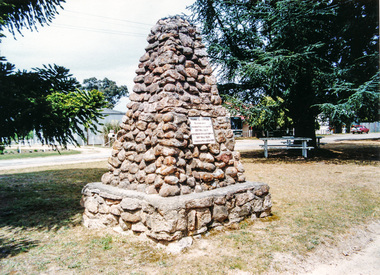 Eltham District Historical Society Inc
Photograph, Hume and Hovell Monument, Swanpool, Spring Excursion, Hume and Hovell's 1824 expedition (Part 2), 26 October 1997, 26/10/1997
... We also deviated down Hume and Hovell Road viewing deer and emu farming and the Bellbourie property now a sanctuary. ...We also deviated down Hume and Hovell Road viewing deer and emu farming and the Bellbourie property now a sanctuary. ...[article by Diana Bassett-Smith in EDHS Newsletter No. 117, November 1997:] MONUMENT HUNTING THE HUME AND HOVELL WAY - Sunday October 26 1997 dawned bright and very warm. Some twenty-five members, complete with picnic baskets, met outside the Eltham Library awaiting the Cobb and Co. large coach which would be taking us on the second leg of our travels along the route of the early explorers Hume and Hovell. Stephen West was our very good driver for the day. He would be guided around the circuitous route by Russell Yeoman who had made a detailed study, not only of the intended route, but of the story of these two explorers. During the trip Russell regaled us with poetry, quotations from the Journals and the History of the Shire of Seymour, "The New Crossing Place" by Martindale, 1982, (now Mitchell Shire due to the recent amalgamations). We headed towards the Hume Highway via Greensborough and Cooper Street and proceeded north to our first stop, noting on the way Monument Hill in the distance which is near Kilmore and, according to Russell, well worth the effort to visit as the view across the valley is magnificent. Past Sunday Creek Valley, Mt Piper and Mt Disappointment, all traversed and noted and named by them. We passed through Tallarook, then onto Seymour where we took photos of the monument telling us that Hume and Hovell had passed through on the 28th of October 1824. We also deviated down Hume and Hovell Road viewing deer and emu farming and the Bellbourie property now a sanctuary. Leaving Seymour behind we travelled up the Avenel Road to the Avenel monument, pyramidal in design of four reducing square blocks with a sharply pointed peak, erected in 1924 in memory of the 1824 exploration. The day was warming up and the countryside showing the dryness of the current drought. A parallel note had been made in their journal too of 1824 of the drought appearance of the country they were traversing. At Seven Creeks, Euroa we stopped for some minutes to check the monument placed 20th November 1924 to commemorate their passage on the 29th December 1824. More photos. Russell had pointed out the abrupt termination of the distant ranges which is noted in their journal. The next monument is beside the road at the entrance to Honey Suckle Creek Caravan Park, Violet Town. The squarish shaped monument some eight feet high is topped with a simple steel cross, and was to mark the date of 28th December 1824 and built for the 20th November 1924. By now it was 12.20 and nearly lunchtime as we drove along the Warranbayne Road to Roach's Road, monument hunting without success. Though there is a large, what appears to be an old timber sign which was hard to read, maybe this was the lost monument. In many of the paddocks hay had been cut and baled or was being cut, what a contrast to the rugged country they had passed through which was smoky from the fires of the natives burning off. By 1.00 pm we were at Benalla and pulled up beside the park where abundant beds of roses filled the air with their scent and the smell of barbecued food twitched the nostrils whilst the cheerful sounds of other picnickers could be heard throughout the park. We left the bus and collected up our picnics, dispersed to the various tables and enjoyed the shade from the various European trees. 2.00 pm and we were on the road again driving along the Benalla, Mansfield, Yea road. The Swanpool monument states that they passed four miles south and returned three miles north. Then we stopped at the Barjarg monument which notes that they camped near this spot. It is again a pyramidal monument and this time topped with a steel arrow indicating their route of the 29th November 1824. Half an hour later we came to another monument, again with a steel arrow marker on top and the plaque dated the 2nd of 12th 1824. Erected on the 12th of 12th 1924. "They blazed the way that we might inherit the land." Another square based and needle topped monument appeared at Yarck near Yea and this plaque records the date of 3 December 1824. Near McGuigans Road Russell related that the expedition had lost a dog but it had found them next day, the dog was apparently torn by a kangaroo. A short while later Russell reminded us here of the problems they encountered in crossing the Goulburn River near Molesworth where banks were high, water deep and wide. "Good coat of grass but quite dry due to drought". At Yea we stopped for afternoon tea and raided the last of our picnics and looked at the monument to their journey of 1824, situated at a corner of the gardens near the bowling green. No photo – we were out of film. We returned home via Kinglake West and Whittlesea past the Yan Yean Reservoir, not full. 5.00 pm back at Eltham we emptied out of the bus and everyone, including Joan Cole, collected their things, Joan also had the major souvenir of the day, a large carp she had picked up from the river bank, her cat was in for a great feast. The day was made so interesting by the informed commentary which Russell provided. His background knowledge of the route and nature of the journey could only have come from many hours of reading and driving the area. Thank you to Russell and to everyone who made the day so informative and pleasurable. Colour photographactivities, hume and hovell, monument, swanpool -
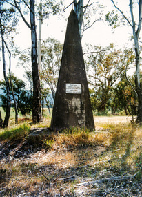 Eltham District Historical Society Inc
Photograph, Hume and Hovell Monument, Barjarg, Spring Excursion, Hume and Hovell's 1824 expedition (Part 2), 26 October 1997, 26/10/1997
... We also deviated down Hume and Hovell Road viewing deer and emu farming and the Bellbourie property now a sanctuary. ...We also deviated down Hume and Hovell Road viewing deer and emu farming and the Bellbourie property now a sanctuary. ...[article by Diana Bassett-Smith in EDHS Newsletter No. 117, November 1997:] MONUMENT HUNTING THE HUME AND HOVELL WAY - Sunday October 26 1997 dawned bright and very warm. Some twenty-five members, complete with picnic baskets, met outside the Eltham Library awaiting the Cobb and Co. large coach which would be taking us on the second leg of our travels along the route of the early explorers Hume and Hovell. Stephen West was our very good driver for the day. He would be guided around the circuitous route by Russell Yeoman who had made a detailed study, not only of the intended route, but of the story of these two explorers. During the trip Russell regaled us with poetry, quotations from the Journals and the History of the Shire of Seymour, "The New Crossing Place" by Martindale, 1982, (now Mitchell Shire due to the recent amalgamations). We headed towards the Hume Highway via Greensborough and Cooper Street and proceeded north to our first stop, noting on the way Monument Hill in the distance which is near Kilmore and, according to Russell, well worth the effort to visit as the view across the valley is magnificent. Past Sunday Creek Valley, Mt Piper and Mt Disappointment, all traversed and noted and named by them. We passed through Tallarook, then onto Seymour where we took photos of the monument telling us that Hume and Hovell had passed through on the 28th of October 1824. We also deviated down Hume and Hovell Road viewing deer and emu farming and the Bellbourie property now a sanctuary. Leaving Seymour behind we travelled up the Avenel Road to the Avenel monument, pyramidal in design of four reducing square blocks with a sharply pointed peak, erected in 1924 in memory of the 1824 exploration. The day was warming up and the countryside showing the dryness of the current drought. A parallel note had been made in their journal too of 1824 of the drought appearance of the country they were traversing. At Seven Creeks, Euroa we stopped for some minutes to check the monument placed 20th November 1924 to commemorate their passage on the 29th December 1824. More photos. Russell had pointed out the abrupt termination of the distant ranges which is noted in their journal. The next monument is beside the road at the entrance to Honey Suckle Creek Caravan Park, Violet Town. The squarish shaped monument some eight feet high is topped with a simple steel cross, and was to mark the date of 28th December 1824 and built for the 20th November 1924. By now it was 12.20 and nearly lunchtime as we drove along the Warranbayne Road to Roach's Road, monument hunting without success. Though there is a large, what appears to be an old timber sign which was hard to read, maybe this was the lost monument. In many of the paddocks hay had been cut and baled or was being cut, what a contrast to the rugged country they had passed through which was smoky from the fires of the natives burning off. By 1.00 pm we were at Benalla and pulled up beside the park where abundant beds of roses filled the air with their scent and the smell of barbecued food twitched the nostrils whilst the cheerful sounds of other picnickers could be heard throughout the park. We left the bus and collected up our picnics, dispersed to the various tables and enjoyed the shade from the various European trees. 2.00 pm and we were on the road again driving along the Benalla, Mansfield, Yea road. The Swanpool monument states that they passed four miles south and returned three miles north. Then we stopped at the Barjarg monument which notes that they camped near this spot. It is again a pyramidal monument and this time topped with a steel arrow indicating their route of the 29th November 1824. Half an hour later we came to another monument, again with a steel arrow marker on top and the plaque dated the 2nd of 12th 1824. Erected on the 12th of 12th 1924. "They blazed the way that we might inherit the land." Another square based and needle topped monument appeared at Yarck near Yea and this plaque records the date of 3 December 1824. Near McGuigans Road Russell related that the expedition had lost a dog but it had found them next day, the dog was apparently torn by a kangaroo. A short while later Russell reminded us here of the problems they encountered in crossing the Goulburn River near Molesworth where banks were high, water deep and wide. "Good coat of grass but quite dry due to drought". At Yea we stopped for afternoon tea and raided the last of our picnics and looked at the monument to their journey of 1824, situated at a corner of the gardens near the bowling green. No photo – we were out of film. We returned home via Kinglake West and Whittlesea past the Yan Yean Reservoir, not full. 5.00 pm back at Eltham we emptied out of the bus and everyone, including Joan Cole, collected their things, Joan also had the major souvenir of the day, a large carp she had picked up from the river bank, her cat was in for a great feast. The day was made so interesting by the informed commentary which Russell provided. His background knowledge of the route and nature of the journey could only have come from many hours of reading and driving the area. Thank you to Russell and to everyone who made the day so informative and pleasurable. Colour photographactivities, hume and hovell, monument, barjarg -
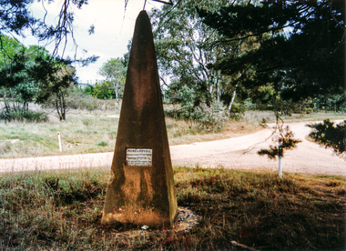 Eltham District Historical Society Inc
Photograph, Hume and Hovell Monument, near Lake Nillachootie, Barjarg, Spring Excursion, Hume and Hovell's 1824 expedition (Part 2), 26 October 1997, 26/10/1997
... We also deviated down Hume and Hovell Road viewing deer and emu farming and the Bellbourie property now a sanctuary. ...We also deviated down Hume and Hovell Road viewing deer and emu farming and the Bellbourie property now a sanctuary. ...[article by Diana Bassett-Smith in EDHS Newsletter No. 117, November 1997:] MONUMENT HUNTING THE HUME AND HOVELL WAY - Sunday October 26 1997 dawned bright and very warm. Some twenty-five members, complete with picnic baskets, met outside the Eltham Library awaiting the Cobb and Co. large coach which would be taking us on the second leg of our travels along the route of the early explorers Hume and Hovell. Stephen West was our very good driver for the day. He would be guided around the circuitous route by Russell Yeoman who had made a detailed study, not only of the intended route, but of the story of these two explorers. During the trip Russell regaled us with poetry, quotations from the Journals and the History of the Shire of Seymour, "The New Crossing Place" by Martindale, 1982, (now Mitchell Shire due to the recent amalgamations). We headed towards the Hume Highway via Greensborough and Cooper Street and proceeded north to our first stop, noting on the way Monument Hill in the distance which is near Kilmore and, according to Russell, well worth the effort to visit as the view across the valley is magnificent. Past Sunday Creek Valley, Mt Piper and Mt Disappointment, all traversed and noted and named by them. We passed through Tallarook, then onto Seymour where we took photos of the monument telling us that Hume and Hovell had passed through on the 28th of October 1824. We also deviated down Hume and Hovell Road viewing deer and emu farming and the Bellbourie property now a sanctuary. Leaving Seymour behind we travelled up the Avenel Road to the Avenel monument, pyramidal in design of four reducing square blocks with a sharply pointed peak, erected in 1924 in memory of the 1824 exploration. The day was warming up and the countryside showing the dryness of the current drought. A parallel note had been made in their journal too of 1824 of the drought appearance of the country they were traversing. At Seven Creeks, Euroa we stopped for some minutes to check the monument placed 20th November 1924 to commemorate their passage on the 29th December 1824. More photos. Russell had pointed out the abrupt termination of the distant ranges which is noted in their journal. The next monument is beside the road at the entrance to Honey Suckle Creek Caravan Park, Violet Town. The squarish shaped monument some eight feet high is topped with a simple steel cross, and was to mark the date of 28th December 1824 and built for the 20th November 1924. By now it was 12.20 and nearly lunchtime as we drove along the Warranbayne Road to Roach's Road, monument hunting without success. Though there is a large, what appears to be an old timber sign which was hard to read, maybe this was the lost monument. In many of the paddocks hay had been cut and baled or was being cut, what a contrast to the rugged country they had passed through which was smoky from the fires of the natives burning off. By 1.00 pm we were at Benalla and pulled up beside the park where abundant beds of roses filled the air with their scent and the smell of barbecued food twitched the nostrils whilst the cheerful sounds of other picnickers could be heard throughout the park. We left the bus and collected up our picnics, dispersed to the various tables and enjoyed the shade from the various European trees. 2.00 pm and we were on the road again driving along the Benalla, Mansfield, Yea road. The Swanpool monument states that they passed four miles south and returned three miles north. Then we stopped at the Barjarg monument which notes that they camped near this spot. It is again a pyramidal monument and this time topped with a steel arrow indicating their route of the 29th November 1824. Half an hour later we came to another monument, again with a steel arrow marker on top and the plaque dated the 2nd of 12th 1824. Erected on the 12th of 12th 1924. "They blazed the way that we might inherit the land." Another square based and needle topped monument appeared at Yarck near Yea and this plaque records the date of 3 December 1824. Near McGuigans Road Russell related that the expedition had lost a dog but it had found them next day, the dog was apparently torn by a kangaroo. A short while later Russell reminded us here of the problems they encountered in crossing the Goulburn River near Molesworth where banks were high, water deep and wide. "Good coat of grass but quite dry due to drought". At Yea we stopped for afternoon tea and raided the last of our picnics and looked at the monument to their journey of 1824, situated at a corner of the gardens near the bowling green. No photo – we were out of film. We returned home via Kinglake West and Whittlesea past the Yan Yean Reservoir, not full. 5.00 pm back at Eltham we emptied out of the bus and everyone, including Joan Cole, collected their things, Joan also had the major souvenir of the day, a large carp she had picked up from the river bank, her cat was in for a great feast. The day was made so interesting by the informed commentary which Russell provided. His background knowledge of the route and nature of the journey could only have come from many hours of reading and driving the area. Thank you to Russell and to everyone who made the day so informative and pleasurable. Colour photographactivities, hume and hovell, monument, barjarg, lake nillachootie -
 Eltham District Historical Society Inc
Photograph, Hume and Hovell Monument, Yea, Spring Excursion, Hume and Hovell's 1824 expedition (Part 2), 26 October 1997, 26/10/1997
... We also deviated down Hume and Hovell Road viewing deer and emu farming and the Bellbourie property now a sanctuary. ...We also deviated down Hume and Hovell Road viewing deer and emu farming and the Bellbourie property now a sanctuary. ...[article by Diana Bassett-Smith in EDHS Newsletter No. 117, November 1997:] MONUMENT HUNTING THE HUME AND HOVELL WAY - Sunday October 26 1997 dawned bright and very warm. Some twenty-five members, complete with picnic baskets, met outside the Eltham Library awaiting the Cobb and Co. large coach which would be taking us on the second leg of our travels along the route of the early explorers Hume and Hovell. Stephen West was our very good driver for the day. He would be guided around the circuitous route by Russell Yeoman who had made a detailed study, not only of the intended route, but of the story of these two explorers. During the trip Russell regaled us with poetry, quotations from the Journals and the History of the Shire of Seymour, "The New Crossing Place" by Martindale, 1982, (now Mitchell Shire due to the recent amalgamations). We headed towards the Hume Highway via Greensborough and Cooper Street and proceeded north to our first stop, noting on the way Monument Hill in the distance which is near Kilmore and, according to Russell, well worth the effort to visit as the view across the valley is magnificent. Past Sunday Creek Valley, Mt Piper and Mt Disappointment, all traversed and noted and named by them. We passed through Tallarook, then onto Seymour where we took photos of the monument telling us that Hume and Hovell had passed through on the 28th of October 1824. We also deviated down Hume and Hovell Road viewing deer and emu farming and the Bellbourie property now a sanctuary. Leaving Seymour behind we travelled up the Avenel Road to the Avenel monument, pyramidal in design of four reducing square blocks with a sharply pointed peak, erected in 1924 in memory of the 1824 exploration. The day was warming up and the countryside showing the dryness of the current drought. A parallel note had been made in their journal too of 1824 of the drought appearance of the country they were traversing. At Seven Creeks, Euroa we stopped for some minutes to check the monument placed 20th November 1924 to commemorate their passage on the 29th December 1824. More photos. Russell had pointed out the abrupt termination of the distant ranges which is noted in their journal. The next monument is beside the road at the entrance to Honey Suckle Creek Caravan Park, Violet Town. The squarish shaped monument some eight feet high is topped with a simple steel cross, and was to mark the date of 28th December 1824 and built for the 20th November 1924. By now it was 12.20 and nearly lunchtime as we drove along the Warranbayne Road to Roach's Road, monument hunting without success. Though there is a large, what appears to be an old timber sign which was hard to read, maybe this was the lost monument. In many of the paddocks hay had been cut and baled or was being cut, what a contrast to the rugged country they had passed through which was smoky from the fires of the natives burning off. By 1.00 pm we were at Benalla and pulled up beside the park where abundant beds of roses filled the air with their scent and the smell of barbecued food twitched the nostrils whilst the cheerful sounds of other picnickers could be heard throughout the park. We left the bus and collected up our picnics, dispersed to the various tables and enjoyed the shade from the various European trees. 2.00 pm and we were on the road again driving along the Benalla, Mansfield, Yea road. The Swanpool monument states that they passed four miles south and returned three miles north. Then we stopped at the Barjarg monument which notes that they camped near this spot. It is again a pyramidal monument and this time topped with a steel arrow indicating their route of the 29th November 1824. Half an hour later we came to another monument, again with a steel arrow marker on top and the plaque dated the 2nd of 12th 1824. Erected on the 12th of 12th 1924. "They blazed the way that we might inherit the land." Another square based and needle topped monument appeared at Yarck near Yea and this plaque records the date of 3 December 1824. Near McGuigans Road Russell related that the expedition had lost a dog but it had found them next day, the dog was apparently torn by a kangaroo. A short while later Russell reminded us here of the problems they encountered in crossing the Goulburn River near Molesworth where banks were high, water deep and wide. "Good coat of grass but quite dry due to drought". At Yea we stopped for afternoon tea and raided the last of our picnics and looked at the monument to their journey of 1824, situated at a corner of the gardens near the bowling green. No photo – we were out of film. We returned home via Kinglake West and Whittlesea past the Yan Yean Reservoir, not full. 5.00 pm back at Eltham we emptied out of the bus and everyone, including Joan Cole, collected their things, Joan also had the major souvenir of the day, a large carp she had picked up from the river bank, her cat was in for a great feast. The day was made so interesting by the informed commentary which Russell provided. His background knowledge of the route and nature of the journey could only have come from many hours of reading and driving the area. Thank you to Russell and to everyone who made the day so informative and pleasurable. Colour photographactivities, hume and hovell, monument, yea -
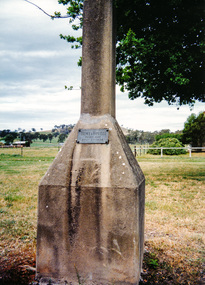 Eltham District Historical Society Inc
Photograph, Hume and Hovell Monument, Yarck (3.12.1824), Spring Excursion, Hume and Hovell's 1824 expedition (Part 2), 26 October 1997, 26/10/1997
... We also deviated down Hume and Hovell Road viewing deer and emu farming and the Bellbourie property now a sanctuary. ...We also deviated down Hume and Hovell Road viewing deer and emu farming and the Bellbourie property now a sanctuary. ...[article by Diana Bassett-Smith in EDHS Newsletter No. 117, November 1997:] MONUMENT HUNTING THE HUME AND HOVELL WAY - Sunday October 26 1997 dawned bright and very warm. Some twenty-five members, complete with picnic baskets, met outside the Eltham Library awaiting the Cobb and Co. large coach which would be taking us on the second leg of our travels along the route of the early explorers Hume and Hovell. Stephen West was our very good driver for the day. He would be guided around the circuitous route by Russell Yeoman who had made a detailed study, not only of the intended route, but of the story of these two explorers. During the trip Russell regaled us with poetry, quotations from the Journals and the History of the Shire of Seymour, "The New Crossing Place" by Martindale, 1982, (now Mitchell Shire due to the recent amalgamations). We headed towards the Hume Highway via Greensborough and Cooper Street and proceeded north to our first stop, noting on the way Monument Hill in the distance which is near Kilmore and, according to Russell, well worth the effort to visit as the view across the valley is magnificent. Past Sunday Creek Valley, Mt Piper and Mt Disappointment, all traversed and noted and named by them. We passed through Tallarook, then onto Seymour where we took photos of the monument telling us that Hume and Hovell had passed through on the 28th of October 1824. We also deviated down Hume and Hovell Road viewing deer and emu farming and the Bellbourie property now a sanctuary. Leaving Seymour behind we travelled up the Avenel Road to the Avenel monument, pyramidal in design of four reducing square blocks with a sharply pointed peak, erected in 1924 in memory of the 1824 exploration. The day was warming up and the countryside showing the dryness of the current drought. A parallel note had been made in their journal too of 1824 of the drought appearance of the country they were traversing. At Seven Creeks, Euroa we stopped for some minutes to check the monument placed 20th November 1924 to commemorate their passage on the 29th December 1824. More photos. Russell had pointed out the abrupt termination of the distant ranges which is noted in their journal. The next monument is beside the road at the entrance to Honey Suckle Creek Caravan Park, Violet Town. The squarish shaped monument some eight feet high is topped with a simple steel cross, and was to mark the date of 28th December 1824 and built for the 20th November 1924. By now it was 12.20 and nearly lunchtime as we drove along the Warranbayne Road to Roach's Road, monument hunting without success. Though there is a large, what appears to be an old timber sign which was hard to read, maybe this was the lost monument. In many of the paddocks hay had been cut and baled or was being cut, what a contrast to the rugged country they had passed through which was smoky from the fires of the natives burning off. By 1.00 pm we were at Benalla and pulled up beside the park where abundant beds of roses filled the air with their scent and the smell of barbecued food twitched the nostrils whilst the cheerful sounds of other picnickers could be heard throughout the park. We left the bus and collected up our picnics, dispersed to the various tables and enjoyed the shade from the various European trees. 2.00 pm and we were on the road again driving along the Benalla, Mansfield, Yea road. The Swanpool monument states that they passed four miles south and returned three miles north. Then we stopped at the Barjarg monument which notes that they camped near this spot. It is again a pyramidal monument and this time topped with a steel arrow indicating their route of the 29th November 1824. Half an hour later we came to another monument, again with a steel arrow marker on top and the plaque dated the 2nd of 12th 1824. Erected on the 12th of 12th 1924. "They blazed the way that we might inherit the land." Another square based and needle topped monument appeared at Yarck near Yea and this plaque records the date of 3 December 1824. Near McGuigans Road Russell related that the expedition had lost a dog but it had found them next day, the dog was apparently torn by a kangaroo. A short while later Russell reminded us here of the problems they encountered in crossing the Goulburn River near Molesworth where banks were high, water deep and wide. "Good coat of grass but quite dry due to drought". At Yea we stopped for afternoon tea and raided the last of our picnics and looked at the monument to their journey of 1824, situated at a corner of the gardens near the bowling green. No photo – we were out of film. We returned home via Kinglake West and Whittlesea past the Yan Yean Reservoir, not full. 5.00 pm back at Eltham we emptied out of the bus and everyone, including Joan Cole, collected their things, Joan also had the major souvenir of the day, a large carp she had picked up from the river bank, her cat was in for a great feast. The day was made so interesting by the informed commentary which Russell provided. His background knowledge of the route and nature of the journey could only have come from many hours of reading and driving the area. Thank you to Russell and to everyone who made the day so informative and pleasurable. Colour photographactivities, hume and hovell, monument, yarck -
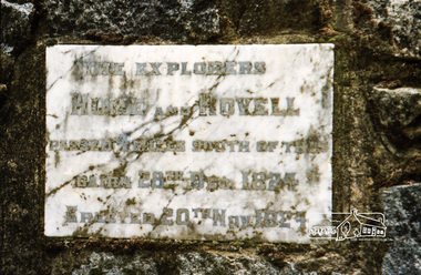 Eltham District Historical Society Inc
Photograph, Spring Excursion, Hume and Hovell bus tour Stage 2, Seymour, Benalla; 26 Oct 1997, 26/10/1997
... We also deviated down Hume and Hovell Road viewing deer and emu farming and the Bellbourie property now a sanctuary. ...We also deviated down Hume and Hovell Road viewing deer and emu farming and the Bellbourie property now a sanctuary. ...MONUMENT HUNTING THE HUME AND HOVELL WAY (Newsletter No. 117, November 1997, by Diana Bassett-Smith) Sunday October 26 1997 dawned bright and very warm. Some twenty-five members, complete with picnic baskets, met outside the Eltham Library awaiting the Cobb and Co. large coach which would be taking us on the second leg of our travels along the route of the early explorers Hume and Hovell. Stephen West was our very good driver for the day. He would be guided around the circuitous route by Russell Yeoman wh9 had made a detailed study, not only of the intended route, but of the story of these two explorers. During the trip Russell regaled us with poetry, quotations from the Journals and the History of the Shire of Seymour, "The New Crossing Place: by Martindale, 1982, (now Mitchell Shire due to the recent amalgamations). We headed towards the Hume Highway via Greensborough and Cooper Street and proceeded north to our first stop, noting on the way Monument Hill in the distance which is near Kilmore and, according to Russell, well worth the effort to visit as the view across the valley is magnificent. Past Sunday Creek Valley, Mt Piper and Mt Disappointment, all traversed and noted and named by them. We passed through Tallarook, then onto Seymour where we took photos of the monument telling us that Hume and Hovell had passed through on the 28th of October 1824. We also deviated down Hume and Hovell Road viewing deer and emu farming and the Bellbourie property now a sanctuary. Leaving Seymour behind we travelled up the Avenel Road to the Avenel monument, pyramidal in design of four reducing square blocks with a sharply pointed peak, erected in 1924 in memory of the 1824 exploration. The day was warming up and the countryside showing the dryness of the current drought. A parallel note had been made in their journal too of 1824 of the drought appearance of the country they were traversing. At Seven Creeks, Euroa we stopped for some minutes to check the monument placed 20th November 1924 to commemorate their passage on the 29th December 1824. More photos. Russell had pointed out the abrupt termination of the distant ranges which is noted in their journal. The next monument is beside the road at the entrance to Honey Suckle Creek Caravan Park, Violet Town. The squarish shaped monument some eight feet high is topped with a simple steel cross, and was to mark the date of 28th December 1824 and built for the 20th November 1924. By now it was 12.20 and nearly lunchtime as we drove along the Warranbayne Road to Roach's Road, monument hunting without success. Though there is a large, what appears to be an old timber sign which was hard to read, maybe this was the lost monument. In many of the paddocks hay had been cut and baled or was being cut, what a contrast to the rugged country they had passed through which was smoky from the fires of the natives burning off By 1.00 pm we were at Benalla and pulled up beside the park where abundant beds of roses filled the air with their scent and the smell of barbecued food twitched the nostrils whilst the cheerful sounds of other picnickers could be heard throughout the park. We left the bus and collected up our picnics, dispersed to the various tables and enjoyed the shade from the various European trees. 2.00 pm and we were on the road again driving along the Benalla, Mansfield, Yea road. The Swanpool monument states that they passed four miles south and returned three miles north. Then we stopped at the Barjarg monument which notes that they camped near this spot. It is again a pyramidal monument and this time topped with a steel arrow indicating their route of the 29th November 1824. Half an hour later we came to another monument, again with a steel arrow marker on top and the plaque dated the 2nd of 12th 1824. Erected on the 12th of 12th 1924. "They blazed the way that we might inherit the land." Another square based and needle topped monument appeared at Yarck near Yea and this plaque records the date of 3 December 1824. Near McGuigans Road Russell related that the expedition had lost a dog but it had found them next day, the dog was apparently torn by a kangaroo. A short while later Russell reminded us here of the problems they encountered in crossing the Goulburn River near Molesworth where banks were high, water deep and wide. "Good coat of grass but quite dry due to drought". At Yea we stopped for afternoon tea and raided the last of our picnics and looked at the monument to their journey of 1824, situated at a corner of the gardens near the bowling green. No photo – we were out of film. We returned home via Kinglake West and Whittlesea past the Yan Yean Reservoir, not full. 5.00 pm back at Eltham we emptied out of the bus and everyone, including Joan Cole, collected their things, Joan also had the major souvenir of the day, a large carp she had picked up from the river bank, her cat was in for a great feast. The day was made so interesting by the informed commentary which Russell provided. His background knowledge of the route and nature of the journey could only have come from many hours of reading and driving the area. Thank you to Russell and to everyone who made the day so informative and pleasurable. Diana Bassett-Smith. Record of the Society's history of activities - Spring 1997 excursionRoll of 35mm colour negative film, 6 stripsFuji 200shire of eltham historical society, activities, pretty hill, seymour, benalla, hume and hovell, monuments -
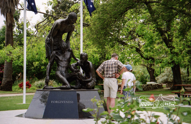 Eltham District Historical Society Inc
Photograph, Spring Excursion, Hume and Hovell bus tour Stage 2, Seymour, Benalla; 26 Oct 1997, 26/10/1997
... We also deviated down Hume and Hovell Road viewing deer and emu farming and the Bellbourie property now a sanctuary. ...We also deviated down Hume and Hovell Road viewing deer and emu farming and the Bellbourie property now a sanctuary. ...MONUMENT HUNTING THE HUME AND HOVELL WAY (Newsletter No. 117, November 1997, by Diana Bassett-Smith) Sunday October 26 1997 dawned bright and very warm. Some twenty-five members, complete with picnic baskets, met outside the Eltham Library awaiting the Cobb and Co. large coach which would be taking us on the second leg of our travels along the route of the early explorers Hume and Hovell. Stephen West was our very good driver for the day. He would be guided around the circuitous route by Russell Yeoman wh9 had made a detailed study, not only of the intended route, but of the story of these two explorers. During the trip Russell regaled us with poetry, quotations from the Journals and the History of the Shire of Seymour, "The New Crossing Place: by Martindale, 1982, (now Mitchell Shire due to the recent amalgamations). We headed towards the Hume Highway via Greensborough and Cooper Street and proceeded north to our first stop, noting on the way Monument Hill in the distance which is near Kilmore and, according to Russell, well worth the effort to visit as the view across the valley is magnificent. Past Sunday Creek Valley, Mt Piper and Mt Disappointment, all traversed and noted and named by them. We passed through Tallarook, then onto Seymour where we took photos of the monument telling us that Hume and Hovell had passed through on the 28th of October 1824. We also deviated down Hume and Hovell Road viewing deer and emu farming and the Bellbourie property now a sanctuary. Leaving Seymour behind we travelled up the Avenel Road to the Avenel monument, pyramidal in design of four reducing square blocks with a sharply pointed peak, erected in 1924 in memory of the 1824 exploration. The day was warming up and the countryside showing the dryness of the current drought. A parallel note had been made in their journal too of 1824 of the drought appearance of the country they were traversing. At Seven Creeks, Euroa we stopped for some minutes to check the monument placed 20th November 1924 to commemorate their passage on the 29th December 1824. More photos. Russell had pointed out the abrupt termination of the distant ranges which is noted in their journal. The next monument is beside the road at the entrance to Honey Suckle Creek Caravan Park, Violet Town. The squarish shaped monument some eight feet high is topped with a simple steel cross, and was to mark the date of 28th December 1824 and built for the 20th November 1924. By now it was 12.20 and nearly lunchtime as we drove along the Warranbayne Road to Roach's Road, monument hunting without success. Though there is a large, what appears to be an old timber sign which was hard to read, maybe this was the lost monument. In many of the paddocks hay had been cut and baled or was being cut, what a contrast to the rugged country they had passed through which was smoky from the fires of the natives burning off By 1.00 pm we were at Benalla and pulled up beside the park where abundant beds of roses filled the air with their scent and the smell of barbecued food twitched the nostrils whilst the cheerful sounds of other picnickers could be heard throughout the park. We left the bus and collected up our picnics, dispersed to the various tables and enjoyed the shade from the various European trees. 2.00 pm and we were on the road again driving along the Benalla, Mansfield, Yea road. The Swanpool monument states that they passed four miles south and returned three miles north. Then we stopped at the Barjarg monument which notes that they camped near this spot. It is again a pyramidal monument and this time topped with a steel arrow indicating their route of the 29th November 1824. Half an hour later we came to another monument, again with a steel arrow marker on top and the plaque dated the 2nd of 12th 1824. Erected on the 12th of 12th 1924. "They blazed the way that we might inherit the land." Another square based and needle topped monument appeared at Yarck near Yea and this plaque records the date of 3 December 1824. Near McGuigans Road Russell related that the expedition had lost a dog but it had found them next day, the dog was apparently torn by a kangaroo. A short while later Russell reminded us here of the problems they encountered in crossing the Goulburn River near Molesworth where banks were high, water deep and wide. "Good coat of grass but quite dry due to drought". At Yea we stopped for afternoon tea and raided the last of our picnics and looked at the monument to their journey of 1824, situated at a corner of the gardens near the bowling green. No photo – we were out of film. We returned home via Kinglake West and Whittlesea past the Yan Yean Reservoir, not full. 5.00 pm back at Eltham we emptied out of the bus and everyone, including Joan Cole, collected their things, Joan also had the major souvenir of the day, a large carp she had picked up from the river bank, her cat was in for a great feast. The day was made so interesting by the informed commentary which Russell provided. His background knowledge of the route and nature of the journey could only have come from many hours of reading and driving the area. Thank you to Russell and to everyone who made the day so informative and pleasurable. Diana Bassett-Smith. Record of the Society's history of activities - Spring 1997 excursionRoll of 35mm colour negative film, 6 stripsFuji 200shire of eltham historical society, activities, pretty hill, seymour, benalla, hume and hovell, monuments