Showing 69 items matching "engineering - melbourne metropolitan board of works"
-
 Port Melbourne Historical & Preservation Society
Plan - MMBW Drainage plan for 184 Dow Street Port Melbourne
... Engineering - Melbourne Metropolitan Board of Works...Port Melbourne Historical & Preservation Society Port Melbourne Town Hall 333 Bay Street Port Melbourne melbourne MMBW Engineering - Melbourne Metropolitan Board of Works Dow Street Melbourne Metropolitan Board of Works plan for 184 Dow Street. ...Melbourne Metropolitan Board of Works plan for 184 Dow Street.mmbw, engineering - melbourne metropolitan board of works, dow street -
 Port Melbourne Historical & Preservation Society
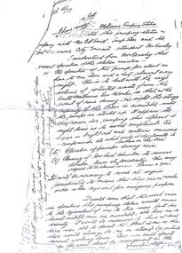
Letter - Letter regarding Pumping Station, Esplanade West, Port Melbourne. 1946, 22 Mar 1946
... Engineering - Melbourne Metropolitan Board of Works...Port Melbourne Historical & Preservation Society Port Melbourne Town Hall 333 Bay Street Port Melbourne melbourne MMBW Engineering - Melbourne Metropolitan Board of Works Pumping Station 1946 Letter regarding the Pumping Station in Esplanade West. ...1946 Letter regarding the Pumping Station in Esplanade West.mmbw, engineering - melbourne metropolitan board of works, pumping station -
 Port Melbourne Historical & Preservation Society
Letter - Letter regarding Pumping Station, Esplanade West, Port Melbourne. 1887, 1887
... Engineering - Melbourne Metropolitan Board of Works...Port Melbourne Historical & Preservation Society Port Melbourne Town Hall 333 Bay Street Port Melbourne melbourne MMBW Engineering - Melbourne Metropolitan Board of Works Pumping Station 1887 Letter regarding the Pumping Station in Esplanade West. ...1887 Letter regarding the Pumping Station in Esplanade West.mmbw, engineering - melbourne metropolitan board of works, pumping station -
 Port Melbourne Historical & Preservation Society
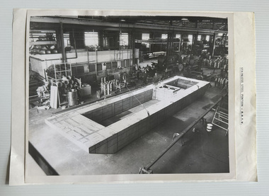
Photograph - Manufacturing MMBW Pontoon at Mytton's
... Engineering - Melbourne Metropolitan Board of Works...Port Melbourne Historical & Preservation Society Port Melbourne Town Hall 333 Bay Street Port Melbourne melbourne Myttons Ltd MMBW Engineering - Melbourne Metropolitan Board of Works On reverse of photograph "SS Pontoon / MMBW". ...B&W photograph of stainless steel MMBW pontoon under construction at Mytton's Ltd, Fisherman's Bend. Partly attached to a plain backing sheet with caption "STAINLESS STEEL PONTOON - M.M.B.W.".On reverse of photograph "SS Pontoon / MMBW".myttons ltd, mmbw, engineering - melbourne metropolitan board of works -
 Port Melbourne Historical & Preservation Society
Photograph - Pumping Station - Esplanade West Port Melbourne, 28 Feb 2026
... Engineering - Board of Works...Engineering - Melbourne Metropolitan Board of Works...Stormwater Drainage Port Melbourne - Esplanade West Pumping Station Built Environment - Civic Engineering - Board of Works Engineering - Melbourne Metropolitan Board of Works Photo of the Pumping Station in Esplanade West Port Melbourne Photograph Pumping Station - Esplanade West Port Melbourne ...Stormwater Drainage Port Melbourne - Esplanade West Pumping StationPhoto of the Pumping Station in Esplanade West Port Melbournebuilt environment - civic, engineering - board of works, engineering - melbourne metropolitan board of works -
 Emerald Museum & Nobelius Heritage Park
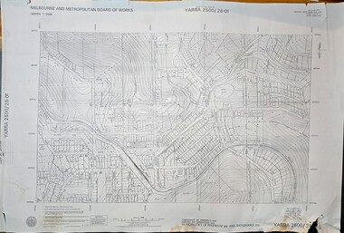
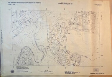
Map - Melbourne & Metropolitan Board of Works, Emerald Victoria, Topographical Map - Amendment 16.1.89, Melbourne and Metropolitan Board of Works, MMBW Topographical Map -Yarra 2500/28.01, 1989
... Date of Photography: January 1981/Base prepared by the Survey Division, Melbourne and Metropolitan Board of Works, under the direction of K.A. Mitchell, Chief Surveyor, Engineering Branch: May 1984/Survey Co-ordination Act plan classification BB2/Revised and re-issued/Latest cadastral amendment 16.1.89/Scale 1:2500/Township of Emerald 5280, Parish of Gembrook 2645, Municipalities of Pakenham 262 And Sherbrooke259/YARRA 2500/28.01 ...Date of Photography: January 1981/Base prepared by the Survey Division, Melbourne and Metropolitan Board of Works, under the direction of K.A. Mitchell, Chief Surveyor, Engineering Branch: May 1984/Survey Co-ordination Act plan classification BB2/Revised and re-issued/Latest cadastral amendment 16.1.89/Scale 1:2500/Township of Emerald 5280, Parish of Gembrook 2645, Municipalities of Pakenham 262 And Sherbrooke259/YARRA 2500/28.01 Image of printed Melbourne & Metropolitan Board of Works topographical map - Emerald - Yarra 2500/28.01 MMBW Topographical Map -Yarra 2500/28.01 Map Melbourne & Metropolitan Board of Works, Emerald Victoria, Topographical Map - Amendment 16.1.89 Melbourne and Metropolitan Board of Works ...Topographical map of Emerald township from 1989, based on photography from 1981Image of printed Melbourne & Metropolitan Board of Works topographical map - Emerald - Yarra 2500/28.01non-fictionTopographical map of Emerald township from 1989, based on photography from 1981emerald -
 Emerald Museum & Nobelius Heritage Park
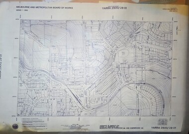
Map - Transparency edition - Melbourne & Metropolitan Board of Works, Emerald Victoria, Topographical Map - Amendment 16.1.89, Melbourne and Metropolitan Board of Works, MMBW Topographical Map -Yarra 2500/28.01, 1989
... Date of Photography: January 1981/Base prepared by the Survey Division, Melbourne and Metropolitan Board of Works, under the direction of K.A. Mitchell, Chief Surveyor, Engineering Branch: May 1984/Survey Co-ordination Act plan classification BB2/Revised and re-issued/Latest cadastral amendment 16.1.89/Scale 1:2500/Township of Emerald 5280, Parish of Gembrook 2645, Municipalities of Pakenham 262 And Sherbrooke259/YARRA 2500/28.01 ...Date of Photography: January 1981/Base prepared by the Survey Division, Melbourne and Metropolitan Board of Works, under the direction of K.A. Mitchell, Chief Surveyor, Engineering Branch: May 1984/Survey Co-ordination Act plan classification BB2/Revised and re-issued/Latest cadastral amendment 16.1.89/Scale 1:2500/Township of Emerald 5280, Parish of Gembrook 2645, Municipalities of Pakenham 262 And Sherbrooke259/YARRA 2500/28.01 Image of printed Melbourne & Metropolitan Board of Works topographical map - Emerald - Yarra 2500/28.01 MMBW Topographical Map -Yarra 2500/28.01 Map Transparency edition - Melbourne & Metropolitan Board of Works, Emerald Victoria, Topographical Map - Amendment 16.1.89 Melbourne and Metropolitan Board of Works ...Topographical map of Emerald township from 1988Image of printed Melbourne & Metropolitan Board of Works topographical map - Emerald - Yarra 2500/28.01non-fictionTopographical map of Emerald township from 1988emerald -
 Emerald Museum & Nobelius Heritage Park
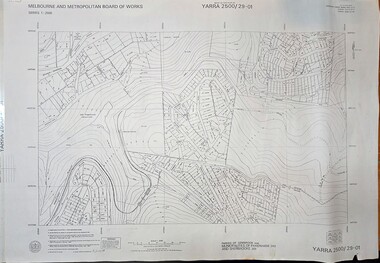
Map - Melbourne & Metropolitan Board of Works, Emerald Victoria, Topographical Map - Amendment 5.1.88, Melbourne and Metropolitan Board of Works, MMBW Topographical Map -Yarra 2500/29.01, 1988
... Date of Photography: January 1984/Base prepared by the Survey Division, Melbourne and Metropolitan Board of Works, under the direction of B.K. Marwick, Chief Surveyor, Engineering Branch: May 1986/Survey Co-ordination Act plan classification BB2/Revised and re-issued/Latest cadastral amendment 15.1.88/Scale 1:2500/Parish of Gembrook 2645, Municipalities of Pakenham 262 And Sherbrooke259/YARRA 2500/29.01 ...Date of Photography: January 1984/Base prepared by the Survey Division, Melbourne and Metropolitan Board of Works, under the direction of B.K. Marwick, Chief Surveyor, Engineering Branch: May 1986/Survey Co-ordination Act plan classification BB2/Revised and re-issued/Latest cadastral amendment 15.1.88/Scale 1:2500/Parish of Gembrook 2645, Municipalities of Pakenham 262 And Sherbrooke259/YARRA 2500/29.01 Image of printed Melbourne & Metropolitan Board of Works topographical map - Emerald - Yarra 2500/29.01 MMBW Topographical Map -Yarra 2500/29.01 Map Melbourne & Metropolitan Board of Works, Emerald Victoria, Topographical Map - Amendment 5.1.88 Melbourne and Metropolitan Board of Works ...Topographical map of Emerald township from 1989, based on photography from 1981Image of printed Melbourne & Metropolitan Board of Works topographical map - Emerald - Yarra 2500/29.01non-fictionTopographical map of Emerald township from 1989, based on photography from 1981emerald -
 Emerald Museum & Nobelius Heritage Park
Map - Transparency of Melbourne & Metropolitan Board of Works, Emerald Victoria, Topographical Map - Amendment 5.1.88, Melbourne and Metropolitan Board of Works, MMBW Topographical Map -Yarra 2500/29.01, 1988
... Date of Photography: January 1984/Base prepared by the Survey Division, Melbourne and Metropolitan Board of Works, under the direction of B.K. Marwick, Chief Surveyor, Engineering Branch: May 1986/Survey Co-ordination Act plan classification BB2/Revised and re-issued/Latest cadastral amendment 15.1.88/Scale 1:2500/Parish of Gembrook 2645, Municipalities of Pakenham 262 And Sherbrooke259/YARRA 2500/29.01 ...Date of Photography: January 1984/Base prepared by the Survey Division, Melbourne and Metropolitan Board of Works, under the direction of B.K. Marwick, Chief Surveyor, Engineering Branch: May 1986/Survey Co-ordination Act plan classification BB2/Revised and re-issued/Latest cadastral amendment 15.1.88/Scale 1:2500/Parish of Gembrook 2645, Municipalities of Pakenham 262 And Sherbrooke259/YARRA 2500/29.01 Image transparency of printed Melbourne & Metropolitan Board of Works topographical map - Emerald - Yarra 2500/29.01 MMBW Topographical Map -Yarra 2500/29.01 Map Transparency of Melbourne & Metropolitan Board of Works, Emerald Victoria, Topographical Map - Amendment 5.1.88 Melbourne and Metropolitan Board of Works ...Topographical map of Emerald township from 1988Image transparency of printed Melbourne & Metropolitan Board of Works topographical map - Emerald - Yarra 2500/29.01non-fictionTopographical map of Emerald township from 1988emerald -
 Melbourne Water
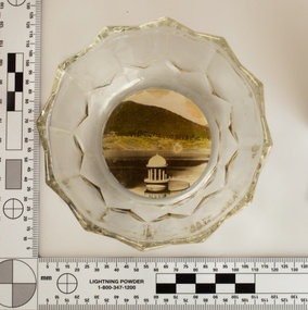
Souvenir confectionery bowl, 1930s-40s
... Melbourne Metropolitan Board of Works (MMBW). They have served the organisation well and have long been celebrated for both their natural beauty and engineering ingenuity. ...Melbourne Metropolitan Board of Works (MMBW). They have served the organisation well and have long been celebrated for both their natural beauty and engineering ingenuity. ...Melbourne Water inherited many of its water assets, such as reservoirs from its predecessor the Melbourne Metropolitan Board of Works (MMBW). They have served the organisation well and have long been celebrated for both their natural beauty and engineering ingenuity. In the nineteenth century Victoria’s fundamental need for water infrastructure went beyond merely functional solutions and reflected the English ideal of the romance and beauty that was embodied in expanses of water. The MMBW further enhanced this notion by incorporating beauty and function in to the Classical and Italianate designs of its infrastructure such as pumping houses and reservoir outlet towers. The reservoir gardens and picnic areas were landscaped with ornamental stonework, exotic trees, decorative flower beds, fern glades pools and rose gardens. All features of the water supply system became widely celebrated as beauty spots that continue to be very popular to this day with tourists and locals alike. This souvenir is a product of that flourishing tourist trade. These water supply sites continue to enhance Melbourne’s charm and liveability and are now recognised as places of cultural and historic significance. This souvenir item has been curated by Melbourne Water as it represents an important historical aspect of the organisation by demonstrating the popularity of its water asset sites as recreational places and tourist attractions, and although these sites are functional parts of the water supply system, they were also designed to be enjoyed by the public both aesthetically and recreationally. Clear glass flower shaped 'depression ware' confectionery bowl, with photographic image of Maroondah Reservoir outlet tower on basemelbourne metropolitan board of works, mmbw, maroondah reservoir, melbourne water, scenic view, souvenir, glass bowl -
 Melbourne Water
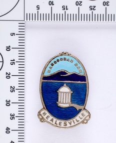
Souvenir lapel pin/brooch Maroondah Dam, 1960s/70s
... Melbourne Metropolitan Board of Works (MMBW). They have served the organisation well and have long been celebrated for both their natural beauty and engineering ingenuity. ...Melbourne Metropolitan Board of Works (MMBW). They have served the organisation well and have long been celebrated for both their natural beauty and engineering ingenuity. ...Melbourne Water inherited many of its water assets, such as reservoirs from its predecessor the Melbourne Metropolitan Board of Works (MMBW). They have served the organisation well and have long been celebrated for both their natural beauty and engineering ingenuity. In the nineteenth century Victoria’s fundamental need for water infrastructure went beyond merely functional solutions and reflected the English ideal of the romance and beauty that was embodied in expanses of water. The MMBW further enhanced this notion by incorporating beauty and function in to the Classical and Italianate designs of its infrastructure such as pumping houses and reservoir outlet towers. The reservoir gardens and picnic areas were landscaped with ornamental stonework, exotic trees, decorative flower beds, fern glads pools and rose gardens. All features of the water supply system became widely celebrated as beauty spots that continue to be very popular to this day with tourists and locals alike. This souvenir is a product of that flourishing tourist trade. These water supply sites continue to enhance Melbourne’s charm and liveability and are now recognised as places of cultural and historic significance. This souvenir item has been curated by Melbourne Water as it represents an important historical aspect of the organisation by demonstrating the popularity of its water asset sites as recreational places and tourist attractions, and although these sites are functional parts of the water supply system, they were also designed to be enjoyed by the public both aesthetically and recreationally. Blue enamel and metal lapel pin/brooch depicting Maroondah Reservoir and outlet tower. Oval shaped with words 'Maroondah Dam' at the top and a ribbon banner containing 'Healesville' at the bottom. Maroondah Dam. Healesvillemelbourne metropolitan board of works, mmbw, maroondah reservoir, melbourne water, scenic view, souvenir, lapel pin, brooch -
 Melbourne Water
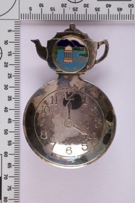
Souvenir tea caddy spoon "Tea Time", Early 1960s
... Melbourne Metropolitan Board of Works (MMBW). They have served the organisation well and have long been celebrated for both their natural beauty and engineering ingenuity. ...Melbourne Metropolitan Board of Works (MMBW). They have served the organisation well and have long been celebrated for both their natural beauty and engineering ingenuity. ...Melbourne Water inherited many of its water assets, such as reservoirs from its predecessor the Melbourne Metropolitan Board of Works (MMBW). They have served the organisation well and have long been celebrated for both their natural beauty and engineering ingenuity. In the nineteenth century Victoria’s fundamental need for water infrastructure went beyond merely functional solutions and reflected the English ideal of the romance and beauty that was embodied in expanses of water. The MMBW further enhanced this notion by incorporating beauty and function in to the Classical and Italianate designs of its infrastructure such as pumping houses and reservoir outlet towers. The reservoir gardens and picnic areas were landscaped with ornamental stonework, exotic trees, decorative flower beds, fern glads pools and rose gardens. All features of the water supply system became widely celebrated as beauty spots that continue to be very popular to this day with tourists and locals alike. This souvenir is a product of that flourishing tourist trade. These water supply sites continue to enhance Melbourne’s charm and liveability and are now recognised as places of cultural and historic significance This souvenir item has been curated by Melbourne Water as it represents an important historical aspect of the organisation by demonstrating the popularity of its water asset sites as recreational places and tourist attractions, and although these sites are functional parts of the water supply system, they were also designed to be enjoyed by the public both aesthetically and recreationally. Tea caddy spoon with clock face engraved showing 4pm on round spoon, tea pot shaped handle with enamel scenic view badge saying 'Healesville' ( depicting Maroondah Reservoir outlet tower). Tea caddy spoon box labelled 'Fine Silverware by Stokes'Stokes and Sons Stokes & Sons logo (Star with S and boomerang) EG. No. 15733melbourne metropolitan board of works, mmbw, maroondah reservoir, melbourne water, scenic view, souvenir, tea caddy spoon -
 Melbourne Water
Photographs: The Maroondah Dam Wall Under Construction, 1921-1922
... Melbourne’s charm and liveability and are now recognised as places of cultural and historic significance These photographs are invaluable in providing insight into many aspects of the Maroondah Reservoir’s early development. The dam wall is a distinctive example of early engineering techniques, with its gravity arch design and concrete construction. The construction of the dam wall represents an important advancement in the technology of dam-building. melbourne metropolitan board of works ...The Maroondah System was first and foremost developed as a functional component of Melbourne's Water Supply System. In addition to functionality, the Melbourne and Metropolitan Board of Works (MMBW) envisioned the Maroondah Reserve to be enjoyed aesthetically and recreationally by the public. This souvenir illustrates the realisation of the Maroondah System as a local recreational and tourist attraction in the early 20th century. The Maroondah Reserve gardens were landscaped with English-style ornamental stonework, exotic trees, flower beds and rose gardens. All features of the water supply system became widely celebrated as beauty spots that continue to be very popular to this day with tourists and locals alike. This souvenir is a product of that flourishing tourist trade. These water supply sites continue to enhance Melbourne’s charm and liveability and are now recognised as places of cultural and historic significanceThese photographs are invaluable in providing insight into many aspects of the Maroondah Reservoir’s early development. The dam wall is a distinctive example of early engineering techniques, with its gravity arch design and concrete construction. The construction of the dam wall represents an important advancement in the technology of dam-building.These images are part of a series of eight photographs which document the construction of the Maroondah Dam in the 1920s.melbourne metropolitan board of works, mmbw, melbourne water, photograph, water, maroondah dam, construction, wall -
 Port Melbourne Historical & Preservation Society
Map - MMBW, c. 1894
... Port Melbourne Historical & Preservation Society Port Melbourne Town Hall 333 Bay Street Port Melbourne melbourne Engineering - Board of Works Sandridge Lagoon Transport - Tramways Engineering - Canals and Drainage Built Environment Gasworks Business and Traders - Hotels Melbourne and Metropolitan Board of Works Plan No. 323,330, 335, 336 Segments shown: As Plan No. ...Melbourne and Metropolitan Board of Works Plan No. 323,330, 335, 336 Segments shown: As Plan No. Large scale plan of lagoon fill area (40'=1")engineering - board of works, sandridge lagoon, transport - tramways, engineering - canals and drainage, built environment, gasworks, business and traders - hotels -
Port Melbourne Historical & Preservation Society
Map - MMBW, 1897
... Port Melbourne Historical & Preservation Society Port Melbourne Town Hall 333 Bay Street Port Melbourne melbourne Engineering - Board of Works Business and Traders - Hotels Built Environment Piers and Wharves - Town Pier Transport - Tramways Melbourne and Metropolitan Board of Works 1895, Plan No. 324, 328, 329 Segments shown: (as plan No's.) ...Melbourne and Metropolitan Board of Works 1895, Plan No. 324, 328, 329 Segments shown: (as plan No's.) Large scale showing hotels, civic and industrial buildings, Graham Street to Bay, Nott and Dow Streets.engineering - board of works, business and traders - hotels, built environment, piers and wharves - town pier, transport - tramways -
Port Melbourne Historical & Preservation Society
Map - MMBW, 1894
... Port Melbourne Historical & Preservation Society Port Melbourne Town Hall 333 Bay Street Port Melbourne melbourne Engineering - Board of Works Built Environment Education - Primary Schools Graham Street State School Port Melbourne Primary School Business and Traders - Hotels 311/H, 17 Melbourne and Metropolitan Board of Works 1894 Plans No. 338, 339, 355, 356 Segments shown: As plan No's: Bridge to Graham, Evans to Nott. ...Melbourne and Metropolitan Board of Works 1894 Plans No. 338, 339, 355, 356 Segments shown: As plan No's: Bridge to Graham, Evans to Nott. (Large scale - 40'=1")311/H, 17engineering - board of works, built environment, education - primary schools, graham street state school, port melbourne primary school, business and traders - hotels -
Port Melbourne Historical & Preservation Society
Map - MMBW, Oct 1894
... Port Melbourne Historical & Preservation Society Port Melbourne Town Hall 333 Bay Street Port Melbourne melbourne Engineering - Board of Works Business and Traders - Hotels Transport - Railways Transport - Tramways "Copywrited 14.1.95" written in red ink "311/H" Melbourne and Metropolitan Board of Works 1894 Plan No. 10 Segements shown: 363, 367 and 368 Large scale (40'=1") Swallow Street to Railway Place, Railway pier to mid railyards Map MMBW ...Melbourne and Metropolitan Board of Works 1894 Plan No. 10 Segements shown: 363, 367 and 368 Large scale (40'=1") Swallow Street to Railway Place, Railway pier to mid railyards"Copywrited 14.1.95" written in red ink "311/H"engineering - board of works, business and traders - hotels, transport - railways, transport - tramways -
Port Melbourne Historical & Preservation Society
Book, Margaret Bride et al, The Borough and Its People, 2013
... Melbourne and Metropolitan Board of Works...Arts and Entertainment...Piers and Wharves...Transport...Natural Environment...Transport - Aviation and Aerodrome...Advertising...Built Environment - Commercial...Celebrations Fetes and Exhibitions...Religion...Industry...Engineering...Port Melbourne Historical & Preservation Society Port Melbourne Town Hall 333 Bay Street Port Melbourne melbourne Built Environment Armed Services Maritime Melbourne and Metropolitan Board of Works Arts and Entertainment Piers and Wharves Transport Natural Environment Transport - Aviation and Aerodrome Advertising Built Environment - Commercial Celebrations Fetes and Exhibitions Religion Industry Engineering Education Families Garden City Sandridge Lagoon Politics Sport Margaret BRIDE nee POLSON Graham BRIDE Indigenous Australians The Borough and Its People. 1839 -1939 Port Melbourne Book with blue front cover and narrow band of 5 photos 3to 5 cms from top. ...The Borough and Its People. 1839 -1939 Port Melbourne Book with blue front cover and narrow band of 5 photos 3to 5 cms from top. Back cover similar in layout plus description of book's theme and contents . PMHPS logo and Port Phillip Council logo on back cover.built environment, armed services, maritime, melbourne and metropolitan board of works, arts and entertainment, piers and wharves, transport, natural environment, transport - aviation and aerodrome, advertising, built environment - commercial, celebrations fetes and exhibitions, religion, industry, engineering, education, families, garden city, sandridge lagoon, politics, sport, margaret bride nee polson, graham bride, indigenous australians -
Port Melbourne Historical & Preservation Society
Book, Robert La Nauze, Engineer to marvellous Melbourne - The Life and Times of William Thwaites, 2011
... Engineering - Board of Works...Built Environment - Civic...William THWAITES...George THWAITES Snr...Elizabeth THWAITES...George THWAITES Jnr...Melbourne and Metropolitan...Port Melbourne Historical & Preservation Society Port Melbourne Town Hall 333 Bay Street Port Melbourne melbourne Engineering - Board of Works Built Environment - Civic William THWAITES George THWAITES Snr Elizabeth THWAITES George THWAITES Jnr Melbourne and Metropolitan Board of Works MMBW All England Eleven Hotel Robert D LA NAUZE Signed by author on title page. ...Engineer to marvellous melbourne - The Life and Times of William Thwaites Second edition by Robert D LA NAUZE (signed). Paperback produced by Melbourne Water to tell the story of the extraordinary young engineer who oversaw the sewering of Melbourne in the 1880s and 90s. Chrome yellow with sepia photo of aquaduct project 1890sSigned by author on title page. Archival PMHPS Stamp 1st page, also donor name in inkengineering - board of works, built environment - civic, william thwaites, george thwaites snr, elizabeth thwaites, george thwaites jnr, melbourne and metropolitan board of works, mmbw, all england eleven hotel, robert d la nauze -
 Port Melbourne Historical & Preservation Society
Booklet, Melbourne and Metropoltan Board of Works, Once Upon a Time ... An M.M.B.W. Picture Story, 1950
... Engineering - Board of Works...Armed Services - Air Force...Built Environment - Commercial...Business and Traders - Hotels...All England Eleven Hotel...MMBW...Werribee Metropolitan Farm...Pier Hotel...Melbourne...Port Melbourne Historical & Preservation Society Port Melbourne Town Hall 333 Bay Street Port Melbourne melbourne Utilities - Sewerage Engineering - Board of Works Armed Services - Air Force Built Environment - Commercial Business and Traders - Hotels All England Eleven Hotel MMBW Werribee Metropolitan Farm Pier Hotel Melbourne and Metropolitan Board of Works "Once Upon a Time ... ..."Once Upon a Time ... An MMBW Picture Story" Small oblong booklet. Front cover red banner title and B&W photo of the All England Eleven Hotel. Describes history of Melbourne's sewerage systemutilities - sewerage, engineering - board of works, armed services - air force, built environment - commercial, business and traders - hotels, all england eleven hotel, mmbw, werribee metropolitan farm, pier hotel, melbourne and metropolitan board of works -
Port Melbourne Historical & Preservation Society
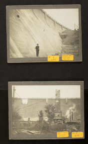
Photograph - Nine inch reticulation pipes at Port Melbourne, "Melbourne water supply", 1890s
... engineering - board of works...built environment - civic...mmbw...sewer...melbourne and metropolitan...Three black and white images taken from: "Melbourne water supply - sewerage schemes" Special edition of the "Building, engineering and mining journal" The operations of the Melbourne and Metropolitan Board of Works...Port Melbourne Historical & Preservation Society Port Melbourne Town Hall 333 Bay Street Port Melbourne melbourne engineering - board of works built environment - civic mmbw sewer melbourne and metropolitan board of works Three black and white images taken from: "Melbourne water supply - sewerage schemes" Special edition of the "Building, engineering and mining journal" The operations of the Melbourne and Metropolitan Board of Works ...Three black and white images taken from: "Melbourne water supply - sewerage schemes" Special edition of the "Building, engineering and mining journal" The operations of the Melbourne and Metropolitan Board of Works. (.01) Plate XXVIII . Nine inch reticulation pipes at Port Melbourne, showing how the trenches in this sandy soil had to be timbered. Four inch junctions for house connections are also shown.engineering - board of works, built environment - civic, mmbw, sewer, melbourne and metropolitan board of works -
Port Melbourne Historical & Preservation Society
Photograph - Shaft at corner Pickles and Graham Streets, Port Melbourne, "Melbourne water supply", 1890s
... engineering - board of works...built environment - civic...mmbw...sewer...melbourne and metropolitan...Three black and white images taken from: "Melbourne water supply - sewerage schemes" Special edition of the "Building, engineering and mining journal" The operations of the Melbourne and Metropolitan Board of Works...Port Melbourne Historical & Preservation Society Port Melbourne Town Hall 333 Bay Street Port Melbourne melbourne engineering - board of works built environment - civic mmbw sewer melbourne and metropolitan board of works Three black and white images taken from: "Melbourne water supply - sewerage schemes" Special edition of the "Building, engineering and mining journal" The operations of the Melbourne and Metropolitan Board of Works ...Three black and white images taken from: "Melbourne water supply - sewerage schemes" Special edition of the "Building, engineering and mining journal" The operations of the Melbourne and Metropolitan Board of Works. (.02) Plate XXIX. Shaft at corner of Pickles and Graham Streets, Port Melbourne, showing method of square timbering adopted and runners for cages.engineering - board of works, built environment - civic, mmbw, sewer, melbourne and metropolitan board of works -
Port Melbourne Historical & Preservation Society
Photograph - Under Port Melbourne Railway, Hobsons Bay Main Sewer, "Melbourne water supply", 1890s
... engineering - board of works...built environment - civic...mmbw...sewer...melbourne and metropolitan...Three black and white images taken from: "Melbourne water supply - sewerage schemes" Special edition of the "Building, engineering and mining journal" The operations of the Melbourne and Metropolitan Board of Works...Port Melbourne Historical & Preservation Society Port Melbourne Town Hall 333 Bay Street Port Melbourne melbourne engineering - board of works built environment - civic mmbw sewer melbourne and metropolitan board of works Three black and white images taken from: "Melbourne water supply - sewerage schemes" Special edition of the "Building, engineering and mining journal" The operations of the Melbourne and Metropolitan Board of Works ...Three black and white images taken from: "Melbourne water supply - sewerage schemes" Special edition of the "Building, engineering and mining journal" The operations of the Melbourne and Metropolitan Board of Works. (.03) Plate XXXI. Under Port Melbourne Railway, Hobsons Bay Main Sewer, Section No 3. This view was taken in compressed air, and shows shield doors in background with men placing extra htdraulic power in position. This view also shows the method of constructing with concrete blocks and iron centreing on which to build the upper portion of the sewer.engineering - board of works, built environment - civic, mmbw, sewer, melbourne and metropolitan board of works -
Port Melbourne Historical & Preservation Society
Plan - MMBW, Melbourne and Metropolitan Board of Works (MMBW), 1894 - 1895
... engineering - board of works...sewerage...mmbw...melbourne and metropolitan...Port Melbourne Historical & Preservation Society Port Melbourne Town Hall 333 Bay Street Port Melbourne melbourne Located on State Library Victoria (SLV) website by member Ray Jelley engineering - board of works sewerage mmbw melbourne and metropolitan board of works Melbourne Metropolitan Board of Works (MMBW) waste water (sewer) plans from 1894-95. ...Located on State Library Victoria (SLV) website by member Ray JelleyMelbourne Metropolitan Board of Works (MMBW) waste water (sewer) plans from 1894-95. Plan numbers 322, 331, 335, 564, 565, 575. Area bounded by Liardet St, East Esplanade, Foote St, Johns(t)on St and Hobsons Bay. Includes Gas works and Distillery.engineering - board of works, sewerage, mmbw, melbourne and metropolitan board of works -
Port Melbourne Historical & Preservation Society
Document, Melbourne and Metropolitan Board of Works, 31 Oct 1935
... engineering - board of works...melbourne and metropolitan...Port Melbourne Historical & Preservation Society Port Melbourne Town Hall 333 Bay Street Port Melbourne melbourne Documentation of drainage works in 1935 for 141 Bridge St. built environment - civic built environment - domestic engineering - board of works melbourne and metropolitan board of works mmbw m h grover r f bentley Hand written details around blueprint of area. ...Documentation of drainage works in 1935 for 141 Bridge St.Plan of drainage 31/10/1935. Details the Melbourne and Metropolitan Board of Works drainage plan for part of Port Melbourne. 141 Bridge St, Port MelbourneHand written details around blueprint of area. Notes made on right hand side and 3 signatures at the bottom.built environment - civic, built environment - domestic, engineering - board of works, melbourne and metropolitan board of works, mmbw, m h grover, r f bentley -
Port Melbourne Historical & Preservation Society
Photograph - Renewal of storm water drain, Esplanade West, Port Melbourne, Janet Bolitho, Jul 2002
... Engineering - Canals and Drainage...Natural Environment...Sandridge Lagoon...Esplanade East...HMAS Lonsdale...Stormwater Drain...Melbourne and Metropolitan Board of Works...Port Melbourne Historical & Preservation Society Port Melbourne Town Hall 333 Bay Street Port Melbourne melbourne Built Environment - Civic Engineering - Canals and Drainage Natural Environment Sandridge Lagoon Esplanade East HMAS Lonsdale Stormwater Drain Melbourne and Metropolitan Board of Works Five coloured photographs of renewal of storm water drain Esplanade West. .01 Esplanade East Street sign .02 Digging .03 Putting in pipe .04 large casing on end of crane .05 Workers Photograph Renewal of storm water drain, Esplanade West, Port Melbourne Janet Bolitho ...Five coloured photographs of renewal of storm water drain Esplanade West. .01 Esplanade East Street sign .02 Digging .03 Putting in pipe .04 large casing on end of crane .05 Workersbuilt environment - civic, engineering - canals and drainage, natural environment, sandridge lagoon, esplanade east, hmas lonsdale, stormwater drain, melbourne and metropolitan board of works -
Port Melbourne Historical & Preservation Society
Plan - Port Melbourne, MMBW, 1987
... Engineering - Canals and Drainage...MMBW...Melbourne and Metropolitan Board of Works...Port Melbourne Historical & Preservation Society Port Melbourne Town Hall 333 Bay Street Port Melbourne melbourne Engineering - Canals and Drainage MMBW Melbourne and Metropolitan Board of Works PMH&PS stamp on back Very large MMBW plan of Port Melbourne 1987 made up of several sections taped together; drains indicated in black Plan Port Melbourne, MMBW ...Very large MMBW plan of Port Melbourne 1987 made up of several sections taped together; drains indicated in blackPMH&PS stamp on backengineering - canals and drainage, mmbw, melbourne and metropolitan board of works -
Port Melbourne Historical & Preservation Society
Plan - Ingles Street, Port Melbourne, 12 Jan 1866
... melbourne Engineering - Roads Streets Lanes and Footpaths Charles CLAY Thomas (Reek) WARREN James BIBBY Signed by surveyor Chas. Clay and James Bibby plus Thomas (Reek) Warren as witness to latter sig. Also a no: 355/H1 added later. Plans for Ingles Street showing both ground plan and longitudinal and traverse sections at Station Place, Heath, Nott and Bay Streets. Plan Ingles Street, Port Melbourne Melbourne and Metropolitan Board of Works ...Plans for Ingles Street showing both ground plan and longitudinal and traverse sections at Station Place, Heath, Nott and Bay Streets.Signed by surveyor Chas. Clay and James Bibby plus Thomas (Reek) Warren as witness to latter sig. Also a no: 355/H1 added later.engineering - roads streets lanes and footpaths, charles clay, thomas (reek) warren, james bibby -
Port Melbourne Historical & Preservation Society
Plan - Melbourne and suburbs sewerage works, MMBW, 1 Jul 1908
... Port Melbourne Historical & Preservation Society Port Melbourne Town Hall 333 Bay Street Port Melbourne melbourne engineering - canals and drainage engineering - board of works MMBW map of Melbourne and Suburbs sewerage work to 1-7-1908. Reticulation areas in red, reticulation areas under construction in blue. Plan Melbourne and suburbs sewerage works, MMBW Melbourne and Metropolitan ...MMBW map of Melbourne and Suburbs sewerage work to 1-7-1908. Reticulation areas in red, reticulation areas under construction in blue.engineering - canals and drainage, engineering - board of works -
Port Melbourne Historical & Preservation Society
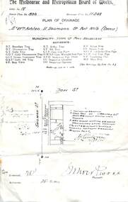
Document - MMBW Drainage Plan for London Hotel 1938, Melbourne & Metropolitan Board of Works, 1938
... Port Melbourne Historical & Preservation Society Port Melbourne Town Hall 333 Bay Street Port Melbourne melbourne Engineering - Board of Works London Family Hotel The Melbourne & Metropolitan Board of Works Plan of Drainage for the London Hotel, Port Melbourne, has details of fixtures & additional work done in 1938. ...The Melbourne & Metropolitan Board of Works Plan of Drainage for the London Hotel, Port Melbourne, has details of fixtures & additional work done in 1938.engineering - board of works, london family hotel