Showing 46 items matching "estuary"
-
 Lakes Entrance Historical Society
Book, East Gippsland Estuary Entrance Management Protocols 2013, 1913
... East Gippsland Estuary Entrance Management Protocols 2013...A report prepared by Water Technology Pty Ltd for East Gippsland Catchment Management Authority relating to the management of the four estuaries, Lake Tyers, Snowy River, Sydenham Inlet, and Mallacoota Inlet....East Gippsland Estuary Entrance Management Protocols 2013 Book ...A report prepared by Water Technology Pty Ltd for East Gippsland Catchment Management Authority relating to the management of the four estuaries, Lake Tyers, Snowy River, Sydenham Inlet, and Mallacoota Inlet.water supply -
 Orbost & District Historical Society
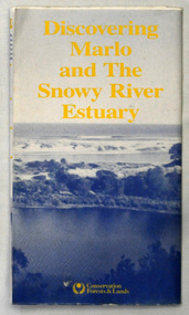
map/brochure, Discovering Marlo & The Snowy River Estuary, December 1988
... Discovering Marlo & The Snowy River Estuary...A folded map/brochure titled "DISCOVERING MARLO & THE SNOWY RIVER ESTUARY". On the front is a photograph of Marlo and the title in yellow print. ...On the back of the brochure are notes on fishing, wildlife and a boating guide, Discovering Marlo & The Snowy River Estuary map/brochure Department of Conservation, Forests and Lands ...In 1983 the Department of Conservation, Forests and Lands replaced the Department of Crown Lands and Survey, the Department of State Forests and the Ministry for Conservation. This brochure/map was used as tourist information in Orbost.This item is a useful research tool.A folded map/brochure titled "DISCOVERING MARLO & THE SNOWY RIVER ESTUARY". On the front is a photograph of Marlo and the title in yellow print. There is a locality map for access to Corringle beach and the brochure Includes a key to fishing sites and various tourist locations. On the back of the brochure are notes on fishing, wildlife and a boating guide, map brochure snowy-river marlo -
 Lakes Entrance Historical Society
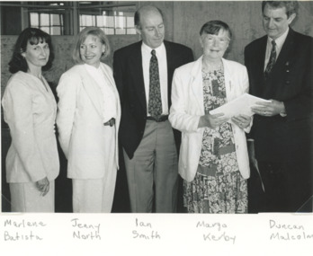
Photograph, Lakes Posat Newspaper, North Arm Foreshore and Estuary Plan, Lakes Entrance Victoria, 1/12/1996 12:00:00 AM
... North Arm Foreshore and Estuary Plan, Lakes Entrance Victoria...Black and white photograph taken at the launch of the North Arm Foreshore and Estuary Plan showing Marlene Battista DNRE, Jennifer North Friends of North Arm, Ian Smith Consultant, Margo Kerby Presidnet of FONA and Duncan Malcolm Shire Commissioner held at Shire Offices Lakes Entrance Victoria...Lakes Entrance Historical Society 4 Marine Parade Lakes Entrance gippsland Environment People Waterways Black and white photograph taken at the launch of the North Arm Foreshore and Estuary Plan showing Marlene Battista DNRE, Jennifer North Friends of North Arm, Ian Smith Consultant, Margo Kerby Presidnet of FONA and Duncan Malcolm Shire Commissioner held at Shire Offices Lakes Entrance Victoria North Arm Foreshore and Estuary Plan, Lakes Entrance Victoria Photograph Lakes Posat Newspaper ...Black and white photograph taken at the launch of the North Arm Foreshore and Estuary Plan showing Marlene Battista DNRE, Jennifer North Friends of North Arm, Ian Smith Consultant, Margo Kerby Presidnet of FONA and Duncan Malcolm Shire Commissioner held at Shire Offices Lakes Entrance Victoriaenvironment, people, waterways -
Glenelg Shire Council Cultural Collection
Postcard - Postcard - Glenelg River Nelson, Victoria, n.d
... Postcard, full colour, sunset at Glenelg River Estuary at Nelson, Victoria....Front: 'Glenelg River Estuary, Nelson - Victoria Australia' - blue print....Glenelg Shire Council Cultural Collection History House Cliff Street Portland great-ocean-road Front: 'Glenelg River Estuary, Nelson - Victoria Australia' - blue print. ...Postcard, full colour, sunset at Glenelg River Estuary at Nelson, Victoria.Front: 'Glenelg River Estuary, Nelson - Victoria Australia' - blue print. -
Lakes Entrance Historical Society
Book, Smith, Ian; Byrne, Gerry; Hanson, Frank, North Arm Foreshore and Estuary Action Plan, 1996
... North Arm Foreshore and Estuary Action Plan...Lakes Entrance Historical Society 4 Marine Parade Lakes Entrance gippsland Waterways Conservation Report of the Action Plan for the future management of the North Arm and its environs, Lakes Entrance, Victoria North Arm Foreshore and Estuary Action Plan Book Smith, Ian; Byrne, Gerry; Hanson, Frank ...Report of the Action Plan for the future management of the North Arm and its environs, Lakes Entrance, Victoriawaterways, conservation -
Moorabbin Air Museum
Book - Description of and listing of international users of the British Aerospace 748, British Aerospace 748, 1986
... Cover showing British Aerospace 748 over estuary...Moorabbin Air Museum Moorabbin Airport 12 First Street Moorabbin melbourne Description of and listing of international users of the British Aerospace 748 Cover showing British Aerospace 748 over estuary British Aerospace 748 Book Description of and listing of international users of the British Aerospace 748 F. ...Description of and listing of international users of the British Aerospace 748Cover showing British Aerospace 748 over estuarynon-fictionDescription of and listing of international users of the British Aerospace 748 -
 Melbourne's Living Museum of the West
Exhibition, Melbourne's Living Museum of the West, Pobblebonk, 2005
... 10th panel (of 10) natural environment panoramic photo-montage about animals of the Maribyrnong River estuary. Portable display printed in colour on fabric, with stands....Melbourne's Living Museum of the West Pipemakers Park Van Ness Avenue Maribyrnong melbourne 10th panel (of 10) natural environment panoramic photo-montage about animals of the Maribyrnong River estuary. Portable display printed in colour on fabric, with stands. ...10th panel (of 10) natural environment panoramic photo-montage about animals of the Maribyrnong River estuary. Portable display printed in colour on fabric, with stands. -
 Warrnambool and District Historical Society Inc.
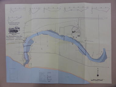
Map - An Angler's map of the Hopkins River Estuary, Angler's map Hopkins River, 1980s
... This is a map of the Hopkins River Estuary prepared by Dr John Sherwood for the benefit of anglers. ...The map of the Hopkins River Estuary is in yellow, blue and black and covers the side of one sheet and three quarters of the other side. ...Angler's map Hopkins River Map An Angler's map of the Hopkins River Estuary ...This is a map of the Hopkins River Estuary prepared by Dr John Sherwood for the benefit of anglers. The information on the sheet includes the location of sand banks, the water depths, boat ramp facilities and public access facilities. Some of the information has been gathered from aerial photographs. The map has been produced by the Warrnambool Institute of Advanced Education which was developed in the late 1960s from the tertiary section of the Warrnambool Technical College and with all its departments established by 1984 at the Sherwood Campus five kilometres from Warrnambool on the Princes Highway. Today the site is occupied by Deakin University, Warrnambool campus. The Warrnambool Anglers’ Club has its headquarters on the banks of the Hopkins River near the mouth of the river and the Lyndoch Aged Care facility.This map is of interest as a specialist one, providing fishermen with detailed information on all aspects of the Hopkins river estuary. Fishing has been both a profession and a popular recreational pursuit for Warrnambool residents since the early days of the city’s settlement. The Hopkins River Estuary has been a focal point for fishermen throughout Warrnambool’s history. This is a sheet of paper folded three times to produce a folded map. The front cover has a black and white photograph of two fishermen with a large fish. The map of the Hopkins River Estuary is in yellow, blue and black and covers the side of one sheet and three quarters of the other side. There is an advertisement for the Hopkins River Boathouse with a black and white sketch of the boathouse and notes on the map written by Dr John Sherwood. There are several diagrams showing the water depths. The map has some silverfish damage and some tearing at the folds. warrnambool anglers’ club, history of warrnambool, hopkins river, hopkins river estuary, john sherwood -
 Orbost & District Historical Society
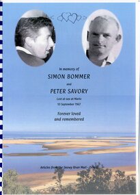
Booklet - newspaper articles, Carrol Preston, IN MEMORY OF SIMON BOMMER AND PETER SAVOURY. Lost at Sea at Marlo.10th September 1967. Forever loved and remembered. Articles from the Snowy River Mail, Orbost, 2023
... Front cover has a blue background which is actually a colour photo of the sky and estuary at Marlo. The faces of two males are at the top of the cover, both in oval shapes. ...Front cover has a blue background which is actually a colour photo of the sky and estuary at Marlo. The faces of two males are at the top of the cover, both in oval shapes. ...This booklet is a compilation by Carrol Preston, of photos and articles in various publications, principally the Snowy River Mail (published in Orbost). These articles relate to the loss of two Orbost young men, Simon Bommer aged 25, and Peter Savoury 27. On the 10 September 1967, these young men were last seen in a small boat at the Snowy River entrance, and were never seen again.This booklet is significant because is records most of the printed reports from 1967 of the deaths of two young men from the Orbost district who were lost in a boating accident near the mouth of the Snowy River. Spiral bound booklet. Front cover has a blue background which is actually a colour photo of the sky and estuary at Marlo. The faces of two males are at the top of the cover, both in oval shapes. The male faces are in b/w.In Memory of SIMON BOMMER and PETER SAVOURY, lost at sea at Marlo, 10th September 1967. Forever loved and remembered. Articles from the Snowy River Mail - Orbost simon bommer, peter savoury, deaths, drowning -
 Sunshine and District Historical Society Incorporated
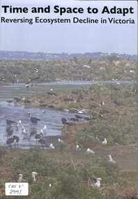
Document - Time and Space to Adapt Reversing Ecosystem Decline in Victoria, Kororoit Institute
... Time and Space to Adapt Reversing Ecosystem Decline in Victoria|Charles Grimes charting the estuaries of the West 1803|Maribyrnong Catchment|The Quarry Belt Maribyrnong River|Stont Creek Diversions|Pelican Lake Jones Creek...Time and Space to Adapt Reversing Ecosystem Decline in Victoria|Charles Grimes charting the estuaries of the West 1803|Maribyrnong Catchment|The Quarry Belt Maribyrnong River|Stont Creek Diversions|Pelican Lake Jones Creek Solf bounded report Document Time and Space to Adapt Reversing Ecosystem Decline in Victoria Kororoit Institute ...Time and Space to Adapt Reversing Ecosystem Decline in Victoria|Charles Grimes charting the estuaries of the West 1803|Maribyrnong Catchment|The Quarry Belt Maribyrnong River|Stont Creek Diversions|Pelican Lake Jones Creek -
 Lara RSL Sub Branch
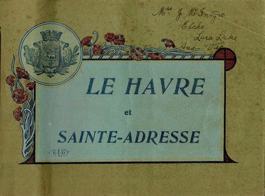
Booklet, Le Havre et Sainte-Adresse, circa 1917
... It is situated on the right bank of the estuary of the river Seine on the Channel southwest of the Pays de Caux. ...It is situated on the right bank of the estuary of the river Seine on the Channel southwest of the Pays de Caux. ...Le Havre is an urban French commune and city in the Seine-Maritime department in the Normandy region of northwestern France. It is situated on the right bank of the estuary of the river Seine on the Channel southwest of the Pays de Caux. The sixteen photos are from circa 1917.Important Booklet as it shows rare photos of an area in France during WW1.Booklet with light cardboard cover bounded by red stringFront page is crest with poppies and titled Le Havre et Sainte-Adresse with initials E.L.D (printers initials). Written in pen on the top right corner are the words Mrs J.McIntyre Elcho Lara Lake Aus - Vic. On the back page is a stamp, Catalogues Industriels E. Le Deley 127, Boulevard Sebastopol, Paris Inside are photos of of the area around Le Havre, Franceelcho, lara lake, le havre, france, ww1, world war one, mcintrye, j. mcintrye, vue general, l'hotel de ville, sainte-adresse, vue d'ensemble du boulevard maritime, sainte-adresse - la heve, sainte-adresse - ensemble du nice-havrais, le casino et la plage, bassin du commerce, sainte-adresse - boulevard felix-faure, panorama pris de l'hotel de ville et rue de paris, le transatlantique "france" 220m de long entrant au port, "la provence" entrant au port par gros temps, sainte-adresse - ensemble du nice-havrais et des nouvelles villas, place gambetta, le nouveau casino marie-christine 1910, le pont du commerce et la bourse -
 Ballarat Heritage Services
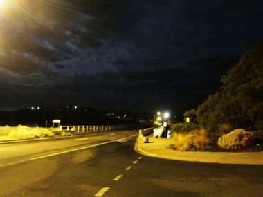
Digital photographs, L.J. Gervasoni, Warrnambool at night, c2015
... ...estuary...Ballarat Heritage Services PO Box 2209 Bakery Hill Post Office goldfields warrnambool merri river estuary coastal night Warrnambool at night Digital photographs L.J. ...warrnambool, merri river, estuary, coastal, night -
 Orbost & District Historical Society
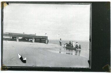
Photograph - boat at Marlo 1890-1910, c.1890-1910
... Marlo is adjacent to the mount of the Snowy River, and is on the estuary of the Snowy. This photo appears to show a group of people enjoying boating on the River. ...Marlo is adjacent to the mount of the Snowy River, and is on the estuary of the Snowy. This photo appears to show a group of people enjoying boating on the River. ...The original of this photo was almost certainly taken at Marlo. From the very earliest times, Marlo was a holiday place for people from Orbost and further afield. Marlo is adjacent to the mount of the Snowy River, and is on the estuary of the Snowy. This photo appears to show a group of people enjoying boating on the River. This photo is significant because it shows an aspect of holiday-making at Marlo c.1890-1910.A b/w copy of a framed photograph of a small boat being held by a man. Eight people are in or near the boat, one man standing in the water. Wooden jetty on the left hand side. Landing at The Jetty. O.S. Green, 31 Malcolm Street, Blackburnsnowy river, marlo, boating -
 Orbost & District Historical Society
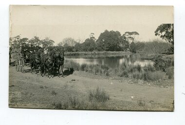
black and white photograph, late 19th - early 20th century
... The Brodribb River is a tributary of the Snowy which enters the estuary at Marlo. ...The Brodribb River is a tributary of the Snowy which enters the estuary at Marlo. This is a pictorial record of a road in Marlo near Orbost in the late 19th-early 20th centuries. ...This photograph was taken at the junction of the Snowy and Brodribb Rivers. The Snowy River starts in New South Wales on the slopes of Mt Kosciuszko, Australia’s highest mountain, in New South Wales. It flows into Bass Strait at Marlo in Victoria. The Brodribb River is a tributary of the Snowy which enters the estuary at Marlo. This is a pictorial record of a road in Marlo near Orbost in the late 19th-early 20th centuries. It also depicts the transport used at that time.A black / white photograph of four men in suits seated in a horse - drawn buggy on a dirt road alongside a creek or river. There appears to be another horse - drawn vehicle behind them.on back - "at the Brodribb - Snowy junction. this road was corduroy (packed logs of tea trees?)brodribb-river snowy-river marlo transport-horse-drawn -
Flagstaff Hill Maritime Museum and Village
Equipment - Fishing Gaff, 20th century
... Its origin is in 16th-century England river and estuary fishing. It saves the fishermen from leaving the boat and standing in the water to retrieve their large fish from the line....Its origin is in 16th-century England river and estuary fishing. It saves the fishermen from leaving the boat and standing in the water to retrieve their large fish from the line. ...A tool produced and used in the fishing industry to assist in retrieving large fish aboard a boat after being hooked on a fishing rod and brought to the vessel's side. Its origin is in 16th-century England river and estuary fishing. It saves the fishermen from leaving the boat and standing in the water to retrieve their large fish from the line.The fishing gaff is an example of equipment used in the fishing industry from around the 16th century that continues to be used today. River and bay fishing has been carried out in Warrnambool from the early to the mid-19th century. Gaff; wooden fishing gaff with a smooth pointed metal hook fixed to the end with black binding.warrnambool, shipwreck coast, flagstaff hill, flagstaff hill maritime museum, flagstaff hill maritime village, fishing gaff, fishing equiipment, fishing industry, rod fishing, river fishing, estuary fishing, fishing tool -
 Ballarat Heritage Services
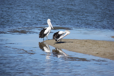
Digital photographs, L.J. Gervasoni, Warrnambool pelicans, c2015
... ...estuary...Ballarat Heritage Services PO Box 2209 Bakery Hill Post Office goldfields warrnambool merri river pelicans birds estuary coastal Colour photograph of two pelicans and their refletions at the Warrnambool beach. ...Colour photograph of two pelicans and their refletions at the Warrnambool beach.warrnambool, merri river, pelicans, birds, estuary, coastal -
 Orbost & District Historical Society
knife and fork, Joseph Rodgers & Son
... The Tabbara Sawmill was located at Brodribb River, at the lower Snowy River estuary. In the early 1900’s bow saws and broad axes were used to selectively log the forest. ...Orbost & District Historical Society Ruskin Street Orbost gippsland The Tabbara Sawmill was located at Brodribb River, at the lower Snowy River estuary. In the early 1900’s bow saws and broad axes were used to selectively log the forest. ...The Tabbara Sawmill was located at Brodribb River, at the lower Snowy River estuary. In the early 1900’s bow saws and broad axes were used to selectively log the forest. Ox driven carts pulled the logs to the Snowy River; the logs were floated downstream to the steam powered mill. The PS Curlip steamboat, transported the timber to growing townships, for schools, houses and farms. The mill closed in 1903. Knife and fork with steel blades and bone handles..Knife - Joseph Rodgers & Son Cuttlers to her Majestyknife fork cutlery domestic-item rodgers-joseph -
 Kew Historical Society Inc
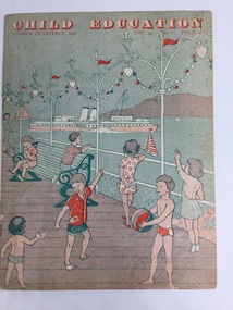
Magazine - Periodical, Messrs Evans Bros Ltd, Child Education : Summer Quarterly, 1958, Vol. 35 No. 7, 1958
... The wall picture [not included with this item] in full colour illustrates many different ships which the children might see at the seaside or on a river estuary."...The wall picture [not included with this item] in full colour illustrates many different ships which the children might see at the seaside or on a river estuary." Child Education : Summer Quarterly, 1958, Vol. 35 No. 7 Magazine Periodical Messrs Evans Bros Ltd Gibbs & Bamforth Ltd ...The Child's Education magazines were published for British teachers between 1924 and 2007 to help them plan activities for the season ahead. The internal pages contain a variety of lesson ideas in the form of a music, art or craft activities. This copy was donated to the Kew Historical Society's collection by the Preshil archives.This 1958 periodical, sourced from the Preshil School. is interesting as it represents the continuing influence of English education and culture in the Australian curriculum in the late 1950s.20 page newsletter containing artwork and articles on the theme shipping and boats. Text on page 3 describes the subject of the issue as 'Around our Coasts'. This is amplified by the text as: "In preparation for the children's seaside holiday, descriptions and pictures of ships, boats and lighthouses, and their work are contained in this issue. Suggestions for handwork are also given. The wall picture [not included with this item] in full colour illustrates many different ships which the children might see at the seaside or on a river estuary."periodicals -- child education uk, themes -- shipping and boats, messrs evans bros ltd -
 Orbost & District Historical Society
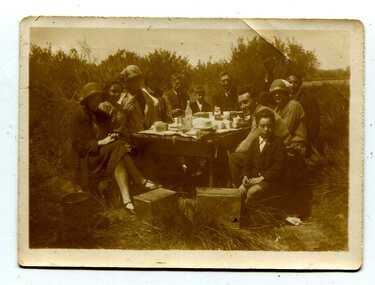
black and white photograph, 1920s - 1930s
... Corringle Slips is situated at the mouth of the Snowy River Estuary. The Corringle Slips were built by Samuel Richardson and sons during the time when the Orbost Shipping Company was operating. ...Corringle Slips is situated at the mouth of the Snowy River Estuary. The Corringle Slips were built by Samuel Richardson and sons during the time when the Orbost Shipping Company was operating. ...There is no record of which family is in the photograph. The slips at Corringle was a popular picnic area for Orbost people. Corringle Slips is situated at the mouth of the Snowy River Estuary. The Corringle Slips were built by Samuel Richardson and sons during the time when the Orbost Shipping Company was operating. The Slips were washed away in the 1893 floods and reassembled by Martin Jorgensen who then became a part owner of the Slips. In the late 1890's, Corringle was a thriving rural community. (Information from Discovering Marlo brochure)This is a pictorial record of family life in Orbost in the first half of the 20th century. It portrays a typical Orbost family enjoying a leisure activity. The clothing can be seen as more formal than that worn at a family picnic in the present day,A black / white photograph of a group of people (adults and children) seated around a table set with a tablecloth on which are teacups, bottles of drink and cake. in the front is a bucket and two metal boxes. They are well-dressed with the men and boys wearing jackets and ties and some of the women wearing cloche style hats.on back - "Family at Slips"corringle-slips-marlo picnic-recreation -
 Flagstaff Hill Maritime Museum and Village
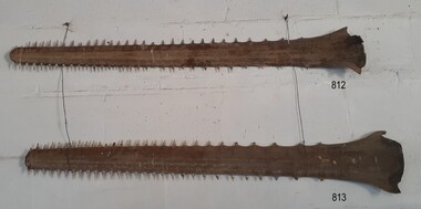
Animal specimen - Sawfish
... They inhabit tropical and subtropical waters of the ocean, rivers and estuaries. They can live from 25 up to even 30 years. ...They inhabit tropical and subtropical waters of the ocean, rivers and estuaries. They can live from 25 up to even 30 years. ...This sawfish rostrum (saw) was once the nose piece of a sawfish, which is a type of ray. Sawfish are also referred to as carpenter sharks although they are not from the shark family. Sawfish use their rostrum to access their food or pray by moving their heads from sided to side. They also use their rostrum as a defensive weapon. Some sawfish can grow as long as seven metres. They inhabit tropical and subtropical waters of the ocean, rivers and estuaries. They can live from 25 up to even 30 years. The pair of sawfish rostrum was originally in the Collection of the old Warrnambool Museum and Art Gallery of the 1880s to 1960s. It was transferred to Flagstaff Hill in the 1970s. The museum had a collection of animal specimens from all over the world.The pair of sawfish rostrum is significant for its association with the old Warrnambool Museum and Art Gallery. The museum called on the public to donate a huge variety of items. People in the 19th century were excited about travel and the world opened up opportunities to discover and learn about 'curiosities' from other cultures.Sawfish nose piece, bill or rostrum, one of a pair. Shape is long, flat and tapering to a rounded end, with pointy thorn-like teeth around the perimeter. sawfish, saw fish, sawfish saw, carpenter shark, rostrum, flagstaff hill, warrnambool, maritime village, maritime museum, flagstaff hill maritime museum & village, shipwreck coast, great ocean road, warrnambool museum and art gallery -
 Flagstaff Hill Maritime Museum and Village
Animal specimen - Sawfish
... They inhabit tropical and subtropical waters of the ocean, rivers and estuaries. They can live from 25 up to even 30 years. ...They inhabit tropical and subtropical waters of the ocean, rivers and estuaries. They can live from 25 up to even 30 years. ...This sawfish rostrum (saw) was once the nose piece of a sawfish, which is a type of ray. Sawfish are also referred to as carpenter sharks although they are not from the shark family. Sawfish use their rostrum to access their food or pray by moving their heads from sided to side. They also use their rostrum as a defensive weapon. Some sawfish can grow as long as seven metres. They inhabit tropical and subtropical waters of the ocean, rivers and estuaries. They can live from 25 up to even 30 years. The pair of sawfish rostrum was originally in the Collection of the old Warrnambool Museum and Art Gallery of the 1880s to 1960s. It was transferred to Flagstaff Hill in the 1970s. The museum had a collection of animal specimens from all over the world.The pair of sawfish rostrum is significant for its association with the old Warrnambool Museum and Art Gallery. The museum called on the public to donate a huge variety of items. People in the 19th century were excited about travel and the world opened up opportunities to discover and learn about 'curiosities' from other cultures.Sawfish nose piece, bill or rostrum, one of a pair. Shape is long, flat and tapering to a rounded end, with pointy thorn-like teeth around the perimeter. sawfish, saw fish, sawfish saw, carpenter shark, rostrum, flagstaff hill, warrnambool, maritime village, maritime museum, flagstaff hill maritime museum & village, shipwreck coast, great ocean road, warrnambool museum and art gallery -
 Wangaratta RSL Sub Branch
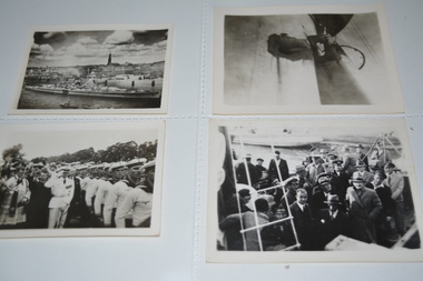
Photograph - Photographs, Admiral Graf Spee
... One of the hunting groups sent by the British Admiralty to search for Graf Spee, comprising three Royal Navy cruisers, HMS Exeter, Ajax and Achilles (the last from the New Zealand Division), found and engaged their quarry off the estuary of the River Plate close to the coast of Uruguay in South America. ...One of the hunting groups sent by the British Admiralty to search for Graf Spee, comprising three Royal Navy cruisers, HMS Exeter, Ajax and Achilles (the last from the New Zealand Division), found and engaged their quarry off the estuary of the River Plate close to the coast of Uruguay in South America. admiral graf spee ww2 montevideo battle of the river plate Inscription in pencil on rear of each photograph 12 black and white unframed photographs of ship at sea Admiral Graf Spee Photograph Photographs ...Photographs of the German ship Admiral Graf Spee which was involved in the Battle of the River Plate, the first naval battle in the Second World War and the first one of the Battle of the Atlantic in South American waters. The German panzerschiff Admiral Graf Spee had cruised into the South Atlantic a fortnight before the war began, and had been commerce raiding after receiving appropriate authorisation on 26 September 1939. One of the hunting groups sent by the British Admiralty to search for Graf Spee, comprising three Royal Navy cruisers, HMS Exeter, Ajax and Achilles (the last from the New Zealand Division), found and engaged their quarry off the estuary of the River Plate close to the coast of Uruguay in South America. 12 black and white unframed photographs of ship at seaInscription in pencil on rear of each photographadmiral graf spee, ww2, montevideo, battle of the river plate -
 Warrnambool and District Historical Society Inc.
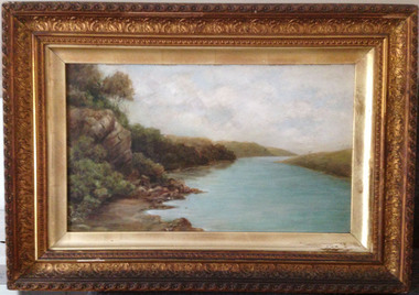
Painting, Hopkins River - Clifton Banks, Early 20th century
... Clifton Banks is the name given to a bank on the Hopkins River Estuary, about one kilometre upstream from Proudfoots Boathouse. ...Warrnambool and District Historical Society Inc. 2 Gilles Street (south of Merri St) Warrnambool great-ocean-road Clifton Banks is the name given to a bank on the Hopkins River Estuary, about one kilometre upstream from Proudfoots Boathouse. ...Clifton Banks is the name given to a bank on the Hopkins River Estuary, about one kilometre upstream from Proudfoots Boathouse. It is at the foot of the property, Clifton which dates from the 1850s. There are several works of art and photographs depicting Clifton Banks which date from the 19th and early 20th centuries. This oil painting is believed to be the work of Emma McGeorge, the wife of Canon Samuel McGeorge, the Vicar of Christ Church, Warrnambool form 1899 to 1905. It is surmised that Emma McGeorge was encouraged by the artist Mary Norman to take up painting as a pastime or to continue with her art interests. Emma McGeorge may have been a pupil of Samuel Pearce Fuller and Mary Norman. She was successful as an exhibitor and entrant in art exhibitions in Warrnambool in the early 1900s. She died in Warrnambool in 1933. This is a highly significant art work as it has artistic merit and is one of the depictions of Clifton Banks on the Hopkins River and so has historical value. It is an example of the high standard of art work that was being produced, especially by women, in the late 19th and early 20th centuries in Warrnambool. It was bought at an auction sale in Camperdown by Les O’Callaghan in 1997. This is an oil painting, probably by Emma McGeorge, on art board of Clifton Banks on the Hopkins River. It has a gilt wooden frame with multi-tiered highly-ornamented outer frames in a gold colouring. The lower frame is discoloured (perhaps by smoke from a fire place) and there is a small piece of wood missing on the lower frame. All the gilding is slightly discoloured. The back has been sealed with pasted paper and there are old tacks and old wire for hanging the picture. There is a label on the back from W. Hickford, the Warrnambool picture framer and handwritten information on the artist and the artwork by Les O’Callaghan.Front: ‘E.Mc.G.’ Back: ‘W. J. Hickford, Picture Dealer, Framer and Gilder, Liebig Street, Warrnambool, Mounting and Repairing, Old Frames Re-gilt, Oakley Printer’ ‘603’ clifton banks, emma mcgeorge, warrnambool, hopkins river estuary -
 Federation University Historical Collection
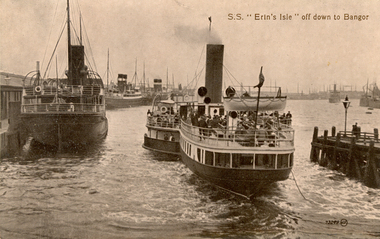
Postcard, S.S. "Erin's Isle" off down to Bangor, 1912
... Surviving World War One, this vessel as lost on 7 February 1919 after hitting a stray mine at the entrance of the Thames Estuary and immediately sank. There were 23 lives lost, and 28 survivors. ...Surviving World War One, this vessel as lost on 7 February 1919 after hitting a stray mine at the entrance of the Thames Estuary and immediately sank. There were 23 lives lost, and 28 survivors. ...Erin's Isle was a paddle steamer built in 1912 by Messrs. A. & J. Inglis Pointhouse, Glasgow, for the Belfast and County Down Railway Company. It provided a regular service between Belfast Lough and Bangor, County Down in the summer season. In November 1915 it was requisitioned by the Admiralty, initially for transport purposes, and later as an auxiliary mine sweeper. Surviving World War One, this vessel as lost on 7 February 1919 after hitting a stray mine at the entrance of the Thames Estuary and immediately sank. There were 23 lives lost, and 28 survivors. Bangor is a city in Gwynedd Unitary Authority, north west Wales, and one of the smallest cities in Britain. This postcard was sent home to Australia by a six bob a day tourist, and member of the Australian AIF on active service. During leave soldiers often visited tourists sites, family, or towns important to their ancestral heritage.A view of paddle steamer with three moored mail steamers are visible to the left, and a pier and lamp on right. A ship can be seen iin distance on right. S.S Erin's Isle off down to Bangorchatham-holmes family collection, bangor, belfast, mail ships, steam ship, six bob a day tourist -
 Warrnambool and District Historical Society Inc.
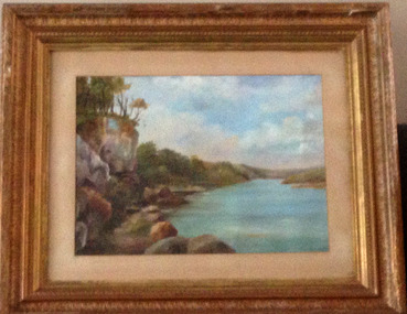
Painting, Hopkins River - Mary Norman - Clifton Banks
... Clifton Banks is the name given to a bank on the Hopkins River Estuary, about one kilometre upstream from Proudfoots Boathouse. ...Warrnambool and District Historical Society Inc. 2 Gilles Street (south of Merri St) Warrnambool great-ocean-road Clifton Banks is the name given to a bank on the Hopkins River Estuary, about one kilometre upstream from Proudfoots Boathouse. ...Clifton Banks is the name given to a bank on the Hopkins River Estuary, about one kilometre upstream from Proudfoots Boathouse. It is at the foot of the property, Clifton, which dates from 1850s. There are several works of art and photographs of Clifton Banks dating from the late 19th and early 20th centuries. Mary Norman (later known as Mary Norman=Bail) came to Warrnambool in 1901, residing with Canon and Mrs McGeorge. She studied art with Samuel Pearce Fuller and later taught art at Fuller's studio and at a local private school. She produced several seascapes and landscapes while she was in Warrnambool, leaving the town in 1905. She devoted the rest of her life to art as an artist and teacher. In 1922 she married Jess Bail. This art work of Clifton Banks won first prize at the 1902 Annual Ararat Art competitions. It was reported at the time that the work was not a copy but had been drawn from nature. The Warrnambool and District Historical Society has five of Mary Norman-Bail's art work.This is a most significant item as it is one of Mary Norman's art works and she was known in the early 20th century as a competent artist and a member of the Victorian Artists' Society. This art work also has historical significance as one of a number of Clifton Banks representations still surviving. Mary Norman also had an impact on the cultural life of Warrnambool during her short stay in the town. She also returned to teach in the town several times for short periods during the summer vacation times.This is a water colour mounted on art board and with a gilt framed and three outer layers of wooden gilded ornamental frames. The sides of the frames are broken in places and the guided material is somewhat discoloured. There are Les O'Callaghan handwritten notes and some typed material on the back giving information on Mary Norman and the art work. The back is sealed with pasted paper and there are both string and wire attached for hanging the pictureBack of art work: 'Diamond Bros, Photo Enlargers, Importers of Mouldings, Mounting Boards, Albums, Mirrors etc, Picture Framers. Mount Cutters and Plush Workers, Studio - 27 Bridge Road, Melbourne, Factory- 45 and 47 Duke Street, Richmond, Armstrong Street, Ballarat, Pirie Street, Adelaide, Brisbane, & Freemantle W.A.'mary norman, clifton banks, warrnambool -
 Dutch Australian Heritage Centre Victoria
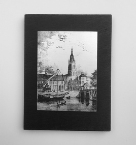
Etching
... The canal was dug in 47 AD under command of Roman general Corbulo, who wished to connect the river Rhine, of which the current Oude Rijn stream in Roman times was the main branch, to the Meuse estuary. It is unclear what the canal's trajectory was beyond the current city of Delft; the Delfshavense Schie canal, which connects Delft to the Nieuwe Maas river was not dug until 1389. ...The canal was dug in 47 AD under command of Roman general Corbulo, who wished to connect the river Rhine, of which the current Oude Rijn stream in Roman times was the main branch, to the Meuse estuary. It is unclear what the canal's trajectory was beyond the current city of Delft; the Delfshavense Schie canal, which connects Delft to the Nieuwe Maas river was not dug until 1389. ...The Vliet is a canal in the western Netherlands, in the province of South Holland. It starts at the Oude Rijn at Leiden and joins the Delfshavense Schie canal at Delft. Places along its banks include Voorschoten, Leidschendam, Voorburg, The Hague and Rijswijk. The canal was dug in 47 AD under command of Roman general Corbulo, who wished to connect the river Rhine, of which the current Oude Rijn stream in Roman times was the main branch, to the Meuse estuary. It is unclear what the canal's trajectory was beyond the current city of Delft; the Delfshavense Schie canal, which connects Delft to the Nieuwe Maas river was not dug until 1389. In the Middle Ages the Vliet was an important trade link that attracted all kinds of trade, as it flowed through the heart of the County of Holland. Windmills have been constructed alongside the Vliet, including the completely renovated mill 'De salamander' in Leidschendam. The Vliet area was particularly attractive among richer families, who built their mansions along its banks.An historic small town scene etched (or possibly printed) on thin metal and subsequently fastened to a plywood backing. The delicately presented scene is said to show the intersection of Old Church Street and the Vliet Canal bridge in Voorburg, as well as a section of wharf. On the canal are one large and two much smaller vessels. A very tall crane-like construction arises from the wharf to the roof of waterside buildings. The people are soberly dressed in possibly 17th or 18th century costumes.On the reverse has been written: "Oude Kerkstraat Brug over de Vliet Voorburg". (Old Church Street; Bridge over the Vliet canal; Voorburg). However, research proves that the church is actually the Old Church in Delft, a short distance further down the Vliet Canal. -
 Orbost & District Historical Society
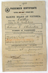
certificate, 30th January 1903
... The Curlip regularly towed one or two barges and up to five barges loaded with local farming produce and timber for the thriving cities, that was loaded offshore or in the Snowy River estuary, tide and depth permitting, on to the trading vessels....The Curlip regularly towed one or two barges and up to five barges loaded with local farming produce and timber for the thriving cities, that was loaded offshore or in the Snowy River estuary, tide and depth permitting, on to the trading vessels. ...This certificate was issued on January 30, 1903 to Captain Alan Richardson by the Marine Board of Victoria entitling her to carry 25 passengers and only 10 passengers when engaged in towage service. Two children under 12 years of age to be reckoned as one passenger. The penalty of 20 pounds would be levied if these limits were exceeded. the certificate was valid until 21st July 1903. The original Paddle Steamer Curlip was built by Sam Richardson and his sons Mark, Albert and Frank, at their sawmill at Tabbara, a pioneering settlement on the Brodribb River, a tributary of the Snowy River. Curlip's keel was laid on 14th October 1889 and PS Curlip was launched in 1890. The Paddle Steamer Curlip was designed to travel up and down the Snowy and Brodribb Rivers with essential supplies from coastal ketches and schooners, that plied their trade up and down the coast between Melbourne, Sydney and Tasmania. The Curlip regularly towed one or two barges and up to five barges loaded with local farming produce and timber for the thriving cities, that was loaded offshore or in the Snowy River estuary, tide and depth permitting, on to the trading vessels.This item is associated with the P.S. Curlip and the Richardson family, early Orbost pioneers.A paper passenger certificate for a river steam ship.Details are handwritten in black and red ink.curlip-p.s. certificate-passenger richardson -
 Melton City Libraries
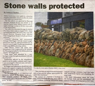
Newspaper, Stone Walls protected, 2015
... Indigenous Australians have built, and continue to build, structures for shelter or hunting or trapping eels and fish in rivers and estuaries around the country. At spots around our coast line there is evidence of simple stone structures built by early maritime explorers. ...Indigenous Australians have built, and continue to build, structures for shelter or hunting or trapping eels and fish in rivers and estuaries around the country. At spots around our coast line there is evidence of simple stone structures built by early maritime explorers. ...Dry stone construction as a technique is used for much more than paddock walls. Across the volcanic plains of western Victoriaare marvelous sheep dips, stock loading ramps, huts, dams, retaining walls, and the rich and largely undiscovered heritage of indigenous dry stone structures. Dry stone walls indicate many aspects of our rural environment; the geological beginnings of the way the landscape was created, the patterns of early settlement by pastoralists and squatters, the types of stock that grazed the land and the methods of cattle and sheep management, of the efforts to thwart the spread of rabbits .... "For the casual but interested observer dry stone walls are good to look at, to photograph, to get up alongside and see the way they are constructed, to appreciate the varying shapes and sizes of stones and learn of the techniques of keeping often quite rounded stones in place. Apart from walls and other dry stone structures on grazing land we can also see dry stone techniques used in other places and in other phases of our history. Indigenous Australians have built, and continue to build, structures for shelter or hunting or trapping eels and fish in rivers and estuaries around the country. At spots around our coast line there is evidence of simple stone structures built by early maritime explorers. Prospectors in early mining encampments used dry stone construction to build retaining walls or the low walls of rudimentary shelters. If the future of dry stone walls in the Australian landscape is to be assured. wall owners and local governments have to accept and embrace their custodial role in assuring the preservation and celebration of walls. This is not an easy task, but, along with putting the necessary statutory mechanisms to ensure their retention, it is a task that must be pursued. The Dry Stone Walls Association of Australia has as its primary goal the increase in awareness of wall owners and local governments of the importance of dry stone walls. It also seeks to increase the level of training of skilled and semi skilled wallers, and the gaining of rudimentary skills by farmers so that they can maintain their own walls". Melton Star Weekly article about the Stone Wallslandscapes of significance -
 Flagstaff Hill Maritime Museum and Village
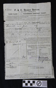
Document - Ticket, voyage, P & O Branch Service, P & O, Australia via The Cape Service, Bef.3rd June 1929
... Ballarat sailed down the Thames estuary and into the English Channel. The next port of call was Southampton, UK, to take on board some technical equipment. ...Ballarat sailed down the Thames estuary and into the English Channel. The next port of call was Southampton, UK, to take on board some technical equipment. ...The bearer of this ticket was George Thomas Henry Phillpot, who was only 17 years old when he sailed on the S.S. Ballarat (II), built in 1921. (The first S.S. Ballarat was built in 1911 and sunk after being hit by a torpedo in 1917 while serving during WWI). George relates his trip from England to Australia, summarised as follows: He caught a bus from Bolton to Manchester, in the north west U.K., then the train from Manchester to London and the boat train to Tilbury Docks (near Gravesend). On the morning of June 7th 1929, the ship S.S. Ballarat sailed down the Thames estuary and into the English Channel. The next port of call was Southampton, UK, to take on board some technical equipment. The S.S. Ballarat then sailed through the Bay of Biscay. Instead of taking the customary route around the Cape of Good Hope, this trip, on her maiden voyage, was through the Suez Canal. She sailed through the Straits of Gibraltar, into the Mediterranean Sea and on to Malta, where George and others paid a local boat owner to take them ashore for a short time. They then sailed to Port Said, stopping to load cargo, then at night through the Suez Canal. They woke up early the next morning to watch the locals working on the banks of the canal. The excessive heat on board the ship caused much illness. As they travelled through the Red Sea, the heat and the smell of oil also caused sickness. On they went through the Arabian Sea to Colombo, the capital of Sri Lanka (which at that time was called Ceylon). A Navigation Slip, donated together with this ticket, shows the coordinates for a location 16 miles from Colombo. They again went ashore for a meal at four-pence a head and a bottle of lemonade for a penny. George and another passenger walked to the slums area and were shocked at the state of it compared to Britain’s slums. They then sailed via the Indian Ocean to Fremantle, stopping again for goods to be unloaded. While ashore, they played a game of soccer against the ship’s crew. Then on to Port Adelaide via the Great Australian Bight. Here they shopped for suitable clothing under the advice of some Australian passengers. They then arrived at Port of Melbourne on July 20th 1929, and two days later (on George’s mother’s birthday). George left for Warrnambool. He received his Citizenship Award in 1971. He conducted an electrical retail business in Liebig Street for many years. His son William became principal of the accounting business Sinclair and Wilson, on the retirement of Bill Sinclair, and was actively involved in support of many community organisations. His daughter-in-law, Glenys Phillpot, is actively involved in the Warrnambool community and local government. George was one of 3 orphans on the S.S. Ballarat. (The daughter and son-in-law of one of the other orphans also live in Warrnambool.) Herbert B.G. Larkin, whose rubber-stamped name appears on the ticket, later migrated to Australia and passed away in NSW in 1944. Of Historical Significance, this ticket is for the ship’s maiden voyage via the Suez Canal route (previously the ship travelled via the Cape of Good Hope). It is also the only existing ticket for the "S.S. Ballarat"(3rd) in our collection. Socially, it shows the fare, luggage restrictions, conditions and weekly provisions for a third-class passenger’s voyage from London to Melbourne, which has research potential. This ticket is also of significance to the Local Community, giving the background of the ancestor of a local family. It was also of Personal Significance to the bearer as he kept and preserved it in his possession for at least 46 years before donating it to our museum, together with a Navigation Slip, a map and a summary of his journey to Australia.Third Class steerage Passenger’s Contract Ticket, accompanied by the Navigation Slip, for passage on board the P & O line’s steamer, S.S. Ballarat, to Australia via the Cape Service, from Port of London to Port of Melbourne. The ticket contract is printed on both sides of a thin paper page. The documents have been completed by hand, and the pages have creases as though they have been folded. Details include the date of sailing, amount paid, and the signature of the P & O Branch Service’s representative. The contract ticket lists weekly provisions for the voyage, a disclaimer of the shipping company, a list of dangerous goods not to be carried on board, and fines. The page has straight edges, top and bottom, and perforated edges on the sides; some perforation holes are complete. A small fleur de lies is printed along the inside of each perforation, forming a decorative left and right border. Stamps and inscriptions are on the contract ticket and navigation slip, which also has a black and white photo of a steam ship.The ticket has been stamped in black, No. ‘1040’. Handwritten details are in black pen and ink. Date of departure: ‘Seventh June [192]9’ for the cost of,’33’ [poind], and the sum of ‘33’ pounds is acknowledged as received. ‘Mr George T.H. PHILLPOT’, the age is written as ‘17’, equal to the status of ‘1’ adult, the total number of persons is ‘One’. The fare is handwritten in pen £’33’ and the total £’33’. It has a purple stamp ‘HERBT. B G LARKIN’ and a crossed out stamp ‘FREDERICK WHITE, A handwritten signature ‘_Seymore’. Under the signature, the date is stamped ‘3 JUNE 1929’.warrnambool, shipwrecked coast, flagstaff hill, flagstaff hill maritime museum, maritime museum, shipwreck coast, flagstaff hill maritime village, s.s.ballarat, phillpot, 7 june 1929, george phillpot, george t.h. phillpot, third class passenger, steerage passenger, herbert b g larkin, ticket, voyage, p & o, australia via the cape, cape of good hope, suez canal, passengers’ contract ticket, navigation slip, s.s. ballarat, steamship, 1929, 3-6-1929, 7-6-1929, third-class, steerage, port of london, port of melboune, 33 pounds, george thomas henry phillpot, herbt. b g larkin, _seymore, bolton, manchester, english channel, southampton, bay of biscay, straits of gibraltar, maritia, port said, arabian sea, colombo, sri lanka, ceylon, indian ocean, fremantle, port adelaide, citizenship, 1971, herbert b.g. larkin, s.s. ballarat ii, -
 The Beechworth Burke Museum
Geological specimen - Fossil Leaves
... It also contributes information on the geographical profile of Victoria as fossilisation usually occur at estuaries and deltas of rivers, river flood plains, ponds and lakes. ...A fossil refers to any remains or traces of past life that are preserved in the rock. It could be remains of plants or animals. Fossil leaves are commonly found on different types of rocks. These fossils can go as far back as the Triassic Age just like the series of fossil plants collected at Denmark Hill, Ipswich in Queensland. Fossils leaves are formed when dead plants get buried by sediments like mud, sand, or volcanic ash. Often, it gets detached cleanly from stems along a special layer of weak cells, then twigs, and, less commonly, cones of conifers and fruits and seeds of flowering plants. Over time, the leaves or pieces of leaves get buried by more sediments and eventually gets 'lithified' or hardened into a rock. Erosions and mining can cause the rocks to break and reveal the fossils buried in it. Fossilisation frequently takes place at sites in the lowlands where deposits of clay, silt, sand are found. This is usually due to weathering and erosion of rocks. Fossil leaves can provide information about ancient Australia's way of living. It contributes to Victorian biodiversity records and its botanical collections. It also contributes information on the geographical profile of Victoria as fossilisation usually occur at estuaries and deltas of rivers, river flood plains, ponds and lakes. This specimen is part of a larger collection of geological and mineral specimens collected from around Australia (and some parts of the world) and donated to the Burke Museum between 1868-1880. A large percentage of these specimens were collected in Victoria as part of the Geological Survey of Victoria that begun in 1852 (in response to the Gold Rush) to study and map the geology of Victoria. Collecting geological specimens was an important part of mapping and understanding the scientific makeup of the earth. Many of these specimens were sent to research and collecting organisations across Australia, including the Burke Museum, to educate and encourage further study.Piece of light brown rock with fossilised leaves in shades of golden yellow and brown.Existing label: Fossil Leaves / Locality unknown / might be worth checking if this is Glossopteris, a Permian age plant. / C. William 16/4/21 geological specimen, geology, geology collection, burke museum, beechworth, fossil leaves, fossilization, 1868 geological survey of victoria, lithified, rocks, fossilised leaf, rock, fossils, leaves