Showing 117 items matching "european pioneers"
-
 Hymettus Cottage & Garden Ballarat
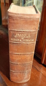
Work on paper - Book, Brande's Dictionary of Science and Literature
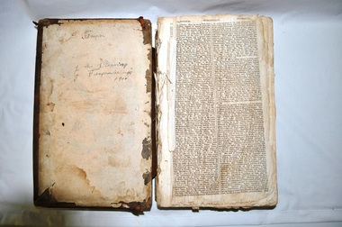
... ...European pioneers...John Pascoe Fawkner Melbourne Libraries European pioneers Note on first page 'Bought at Foster & Davis Sale Jan 44 By JPF and signed John Pascoe Fawkner.' ...john pascoe fawkner, melbourne, libraries, european pioneers, -
 Ballarat Heritage Services
Photograph - Colour, Vaughan Chinese Cemetery, 2017, 16/07/2017
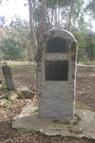
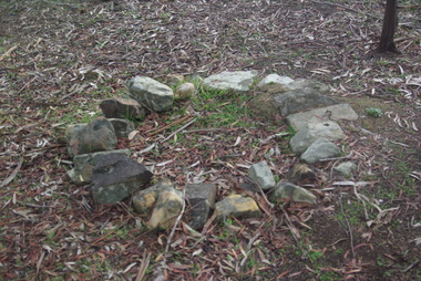
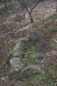
... This site was used as a burial ground from 1855 (about) to 1859. European and Chinese pioneers rest here. The Bendigo Chinese Society Honouring the memory of their Countrymen, fenced the site, 1928. ...Ballarat Heritage Services PO Box 2209 Bakery Hill Post Office goldfields vaughan vaughan springs vaughan chinese cemetery chinese This site was used as a burial ground from 1855 (about) to 1859. European and Chinese pioneers rest here. The Bendigo Chinese Society Honouring the memory of their Countrymen, fenced the site, 1928. ...This site was used as a burial ground from 1855 (about) to 1859. European and Chinese pioneers rest here. The Bendigo Chinese Society Honouring the memory of their Countrymen, fenced the site, 1928. Population of Vaughan 1859, 13000vaughan, vaughan springs, vaughan chinese cemetery, chinese -
 Ballarat Heritage Services
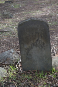
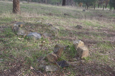
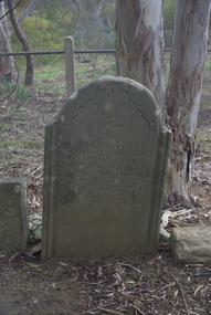
Photograph - Colour, Grave at Vaughan Chinese Cemetery, 2017, 16/07/2017
... This site was used as a burial ground from 1855 (about) to 1859. European and Chinese pioneers rest here. The Bendigo Chinese Society Honouring the memory of their Countrymen, fenced the site, 1928 Population of Vaughan 1859, 13000...Ballarat Heritage Services PO Box 2209 Bakery Hill Post Office goldfields vaughan vaughan springs vaughan chinese cemetery chinese This site was used as a burial ground from 1855 (about) to 1859. European and Chinese pioneers rest here. The Bendigo Chinese Society Honouring the memory of their Countrymen, fenced the site, 1928 Population of Vaughan 1859, 13000 Grave at Vaughan Chinese Cemetery, 2017 Photograph - Colour ...This site was used as a burial ground from 1855 (about) to 1859. European and Chinese pioneers rest here. The Bendigo Chinese Society Honouring the memory of their Countrymen, fenced the site, 1928 Population of Vaughan 1859, 13000vaughan, vaughan springs, vaughan chinese cemetery, chinese -
 Ballarat Heritage Services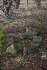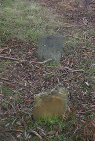
Photograph - Colour, Grave at Vaughan Chinese Cemetery, 2017, 16/07/2017
... This site was used as a burial ground from 1855 (about) to 1859. European and Chinese pioneers rest here. The Bendigo Chinese Society Honouring the memory of their Countrymen, fenced the site, 1928 Population of Vaughan 1859, 13000...Ballarat Heritage Services PO Box 2209 Bakery Hill Post Office goldfields vaughan vaughan springs vaughan chinese cemetery chinese thomas eynon This site was used as a burial ground from 1855 (about) to 1859. European and Chinese pioneers rest here. The Bendigo Chinese Society Honouring the memory of their Countrymen, fenced the site, 1928 Population of Vaughan 1859, 13000 Grave at Vaughan Chinese Cemetery, 2017 Photograph - Colour ...This site was used as a burial ground from 1855 (about) to 1859. European and Chinese pioneers rest here. The Bendigo Chinese Society Honouring the memory of their Countrymen, fenced the site, 1928 Population of Vaughan 1859, 13000vaughan, vaughan springs, vaughan chinese cemetery, chinese, thomas eynon -
 Ballarat Heritage Services
Pamphlet - Photograph - Colour, Grave at Vaughan Chinese Cemetery, 2017, 16/07/2017
... This site was used as a burial ground from 1855 (about) to 1859. European and Chinese pioneers rest here. The Bendigo Chinese Society Honouring the memory of their Countrymen, fenced the site, 1928 Population of Vaughan 1859, 13000...Ballarat Heritage Services PO Box 2209 Bakery Hill Post Office goldfields vaughan vaughan springs vaughan chinese cemetery chinese thomas eynon This site was used as a burial ground from 1855 (about) to 1859. European and Chinese pioneers rest here. The Bendigo Chinese Society Honouring the memory of their Countrymen, fenced the site, 1928 Population of Vaughan 1859, 13000 Grave at Vaughan Chinese Cemetery, 2017 Pamphlet Photograph - Colour ...This site was used as a burial ground from 1855 (about) to 1859. European and Chinese pioneers rest here. The Bendigo Chinese Society Honouring the memory of their Countrymen, fenced the site, 1928 Population of Vaughan 1859, 13000vaughan, vaughan springs, vaughan chinese cemetery, chinese, thomas eynon -
 Ballarat Heritage Services
Photograph - Colour, Grave at Vaughan Chinese Cemetery, 2017, 16/07/2017
... This site was used as a burial ground from 1855 (about) to 1859. European and Chinese pioneers rest here. The Bendigo Chinese Society Honouring the memory of their Countrymen, fenced the site, 1928 Population of Vaughan 1859, 13000...Ballarat Heritage Services PO Box 2209 Bakery Hill Post Office goldfields vaughan vaughan springs vaughan chinese cemetery chinese thomas eynon This site was used as a burial ground from 1855 (about) to 1859. European and Chinese pioneers rest here. The Bendigo Chinese Society Honouring the memory of their Countrymen, fenced the site, 1928 Population of Vaughan 1859, 13000 Grave at Vaughan Chinese Cemetery, 2017 Photograph - Colour ...This site was used as a burial ground from 1855 (about) to 1859. European and Chinese pioneers rest here. The Bendigo Chinese Society Honouring the memory of their Countrymen, fenced the site, 1928 Population of Vaughan 1859, 13000vaughan, vaughan springs, vaughan chinese cemetery, chinese, thomas eynon -
 Ballarat Heritage Services
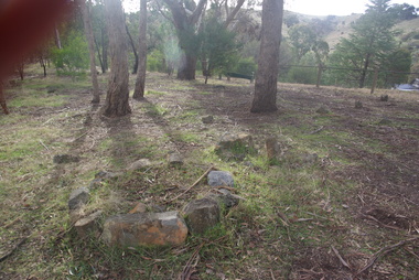
Photograph - Colour, House Near Vaughan Chinese Cemetery, 2017, 16/07/2017
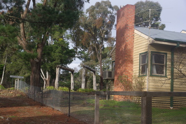
... This site was used as a burial ground from 1855 (about) to 1859. European and Chinese pioneers rest here. The Bendigo Chinese Society Honouring the memory of their Countrymen, fenced the site, 1928 Population of Vaughan 1859, 13000...Ballarat Heritage Services PO Box 2209 Bakery Hill Post Office goldfields vaughan vaughan springs vaughan chinese cemetery chinese thomas eynon This site was used as a burial ground from 1855 (about) to 1859. European and Chinese pioneers rest here. The Bendigo Chinese Society Honouring the memory of their Countrymen, fenced the site, 1928 Population of Vaughan 1859, 13000 House Near Vaughan Chinese Cemetery, 2017 Photograph - Colour ...This site was used as a burial ground from 1855 (about) to 1859. European and Chinese pioneers rest here. The Bendigo Chinese Society Honouring the memory of their Countrymen, fenced the site, 1928 Population of Vaughan 1859, 13000vaughan, vaughan springs, vaughan chinese cemetery, chinese, thomas eynon -
 Warrnambool and District Historical Society Inc.
Document (item) - Allansford land purchase document, Land purchase document, 1864
... She had purchased the land, via an agent, from John Allan who with his brothers were the pioneer European settlers in the Allansford area. ...She had purchased the land, via an agent, from John Allan who with his brothers were the pioneer European settlers in the Allansford area. ...This paper contains details of the purchase of Lot 11 in the Township of Allansford in 1864. The purchaser, Isabella McQueen, was born in Scotland in 1814, married Alexander McQueen in 1850 and with her family migrated to Australia in 1854. After her husband's death in 1860 Isabella purchased the land in Frank Street, Allansford in 1864 and lived in a house there with family members until her death in 1895. She had purchased the land, via an agent, from John Allan who with his brothers were the pioneer European settlers in the Allansford area. John Allan had created the township of Allansford in the mid 1850s by sub-dividing the land he owned there. John Allan moved to the Gippsland area late in 1864. This piece of paper is most significant as it is an original record of an early transaction in the history of Allansford, a town now part of Warrnambool City.Mrs isabella McQueen Bot. of Robert Gregory As agent for J M Allan Esq. Lot no. 11 as marked and described on the Plan of Subdivision of the Township of Allansford. For which I have received the um of five pounds Stg. being the purchase money of same. Robert Gregory 21st October 1864allansford history, john allan, isabella mcqueen -
 Kiewa Valley Historical Society
Bible - Family, Brown's Superb Bible, circa early 1800's to 1900
... This is the family bible and relates to the major religious beliefs of the early settlers who pioneered British/European colonial settlements. Although the first pages are missing the family name is written on the inside cover (J.A. ...This is the family bible and relates to the major religious beliefs of the early settlers who pioneered British/European colonial settlements. Although the first pages are missing the family name is written on the inside cover (J.A. ...This item represents one of the most important spiritual references available to a settler in countryside Australia in the period 1800s to 1900s. This is the family bible and relates to the major religious beliefs of the early settlers who pioneered British/European colonial settlements. Although the first pages are missing the family name is written on the inside cover (J.A. Fleming). Most of these bibles (of this era) showed the family genealogical record of births, baptism and deaths, however this bible has the relevant pages missing. This bible would have provided the spiritual strength needed in bad times. Throughout this bible there are copies of specially commissioned lithographic engravings, each published between March 1812 to December 1813. These photographs were provided to visualise the theme of the each chapter.This item is significant because it shows that spiritualism of a small group (family in this case) is a vital part of the cohesive forces which holds a family(the basic subgroup of society) together, against all odds, and external pressures. It demonstrates that even in isolated or sparsely populated areas, the mores of a christian community is as strong as that of the cities. Mountains (Victorian Alps) have throughout the enlightened Ages been of extreme spiritual significance and this beholds those who live in this area.The families in the Kiewa Valley fall into the "isolated rural area" when this bible was first in use. This bible contains as its introduction,scripture history starting from 4004 BC "God created all things" to 2900 AD end of the World. There is a high degree of probability that this bible belonged to a member or members of the John Ambrose Flemming extended family who resided in the Kiewa Valley. J.A. Flemming (a famous English electrical engineer and physicist) invented the first diode in 1904). He and his family were devout Christians and he helped establish the Evolution Protest Movement.Leather bound bible. Leather in some areas is in tatters revealing the thick multi-layered cardboard backing. Front and back covers are held together by the thin leather binding. The lettering of the bible is large.Hand written inscriptions are in ink on the inside front cover, " J Tangam" at the top, "J A Fleming" underneath "Tangambalanga" and below that "1900". There are penciled dates "1937 1900" which have at one point in time been scribbled over in pencil. Although not marked on cover, the bible was known as "Brown's Bible" after the Author, the Rev. John Brown. Each of the major chapters is introduced by a copy of a lithographic print detailing the relevant religious picture and all are headed by "Brown's Superb Bible" and the date of the print. bible, rev. john brown, old and new testament, christianity -
 Warrnambool and District Historical Society Inc.
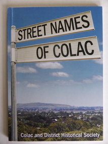
Book, Street Names of Colac, 2008
... European settlement began in 1837. The book was commenced by Ian McIntosh in the 1970s and in 2005 the Colac and District Historical Society took on the project again with the major editors being Ida and Andrew McIntosh. This book is of interest, particularly those in the Western District of Victoria, as it contains information on Colac streets, many of which were named after pioneers of the district. ...This is a book giving information on the streets of Colac and the origins of the names. Colac is a city 150 kilometres south west of Melbourne and is a commercial centre for a major agricultural area. It is situated near the 3rd largest volcanic plain in the world and European settlement began in 1837. The book was commenced by Ian McIntosh in the 1970s and in 2005 the Colac and District Historical Society took on the project again with the major editors being Ida and Andrew McIntosh. This book is of interest, particularly those in the Western District of Victoria, as it contains information on Colac streets, many of which were named after pioneers of the district. The book will be useful for research. This is a soft cover book of 60 pages. The cover has a blue background and features a colour photograph (mainly in green, blue and white tonings) of a panorama of the Colac district. The photograph extends over the front and back covers. The book contains the names and name origins of Colac streets in alphabetical order and many black and white photographs. The pages have a glued binding. Front Cover: ‘Street Names of Colac’ ‘Colac and District Historical Society’ history of colac, colac and district historical society, street names of colac, ian mcintosh -
 Warrnambool and District Historical Society Inc.
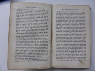
Book, Divine Conduct or the Mystery of Providence, Early to mid 19th century
... European settlers arrived in the new settlement of Warrnambool. The first Sunday School in Warrnambool was located in McDowell’s Store and run by Thomas Denney and Richard Osburne. The latter in 1851 commenced Warrnambool’s first newspaper, the Warrnambol Examiner and in 1887 published an important history of Warrnambool. Janet Garden McGhie was the daughter of Matthew and Isabella McGhie who were pioneer...European settlers arrived in the new settlement of Warrnambool. The first Sunday School in Warrnambool was located in McDowell’s Store and run by Thomas Denney and Richard Osburne. The latter in 1851 commenced Warrnambool’s first newspaper, the Warrnambol Examiner and in 1887 published an important history of Warrnambool. Janet Garden McGhie was the daughter of Matthew and Isabella McGhie who were pioneer ...This is a book, ‘Divine Conduct or the Mystery of Providence’ originally written by the Rev. John Flavel in 1677. This is a later edition with no date listed but it is presumed it was re-published in the 19th century. The book was given to Janet McGhie in 1849, the first anniversary of the Warrnambool Sunday School, just 14 months after the first European settlers arrived in the new settlement of Warrnambool. The first Sunday School in Warrnambool was located in McDowell’s Store and run by Thomas Denney and Richard Osburne. The latter in 1851 commenced Warrnambool’s first newspaper, the Warrnambol Examiner and in 1887 published an important history of Warrnambool. Janet Garden McGhie was the daughter of Matthew and Isabella McGhie who were pioneer settlers in Warrnambool. Janet McGhie married Alfred Coulstock at the age of 17 and died in Warrnambool in 1918 at the age of 80. She was aged 11 when she received this book and one wonders what she made of the ponderous text. This book is very precious as one of the few mementos we have of the very early days of Warrnambool’s settlement. It gives us a date for the establishment of the first Sunday School and the name of one of the award winners. It is also an interesting example of the pious and ponderous writings that young children were expected to read in the mid 19th century. It is presumed that at that time there would not have been a great choice of reading material available in Warrnambool to give to childrenThis is a hard cover book of 252 pages. The dark green cover has gold lettering on the spine which is almost obliterated. The cover is partly detached from its binding and is much stained and blotched. There is an inscription on the inside front cover in black ink and a red stamp of the Warrnambool & District Historical Society on the first page. There are some indecipherable pencil markings on this first page and the last page.‘Janet McGhee (or McGhie), 1st Anniversary Warrnambool Sunday School, Decr 3rd 1849’janet mcghie, warrnambool sunday school -
 Warrnambool and District Historical Society Inc.
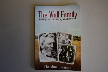
Book, The Wall Family - Weaving the Threads of Memories, 2021
... He came to Warrnambool in the first year of its European settlement (1847) and was a landholder and a hotel keeper for many years operating the Bush Inn, Wangoom, the Commercial Hotel, Warrnambool, the Warrnambool Hotel, the Rising Sun Hotel, Warrnambool, the Brefney Hotel, Framlingham, the Commercial Hotel, Panmure and the Woolshed Inn, Hexham. This book is of considerable interest as it gives the history of an important pioneer ...Historical details of William Wall and his family and descendantsThis is a book of 172 pages. The front cover has three black and white photographs with a background of a colour photograph of a country scene. The printing is red, white and blue. The back cover has red printing and a colour plan of country allotments. . The pages contain printed text, black and white photographs and other images. non-fictionHistorical details of William Wall and his family and descendantswilliam wall, hotels of warrnambool and district -
 Kiewa Valley Historical Society
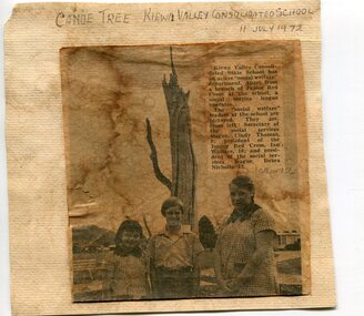
Newspaper clipping 11/7/72 Canoe tree in Kiewa & Photo-Tawonga Homestead
... The tree trunk, located at Kiewa, would have been used at the beginning of European settlement in the Kiewa Valley or just before contact was made. 2. Pictorial record of the graves of early pioneers C Ibbotson, Mrs Elizabeth Eyre and John Eyre who died between 1858 – 1904, all located at Tawonga Homestead ...The tree trunk, located at Kiewa, would have been used at the beginning of European settlement in the Kiewa Valley or just before contact was made. 2. Pictorial record of the graves of early pioneers C Ibbotson, Mrs Elizabeth Eyre and John Eyre who died between 1858 – 1904, all located at Tawonga Homestead 1. ...1. Kiewa Valley Consolidated School was established in 1953 combining Dederang North, Kergunyah, Gundowring, Kiewa, Gundowring Upper, Red Bluff, Charleroi and Gundowing North schools on a 10 acre site with 11 rooms at Kiewa. The bark was cut from the canoe tree, by aboriginal craftsmen, to produce a canoe for fishing in the rivers running through the Kiewa Valley either before or just after the 1800's. The tree trunk, located at Kiewa, would have been used at the beginning of European settlement in the Kiewa Valley or just before contact was made. 2. Pictorial record of the graves of early pioneers C Ibbotson, Mrs Elizabeth Eyre and John Eyre who died between 1858 – 1904, all located at Tawonga Homestead 1. The above schools are in the Kiewa Valley. The date and number of combined schools give insight into the change in population and families in the Kiewa Valley before and after 1953. The tree was found along the Kiewa River and indicates that Aborigines lived by the river and used tree bark to craft canoes to cross rivers and to fish in the deeper sections of the river. 2. Pictorial record of the early history of Kiewa Valley pioneers whose descendants have lived and worked in the Kiewa Valley for many years 1. Newspaper article of local school children visiting a canoe tree in Kiewa July 11, 1972. mounted on buff card 2. Black and white photo of pioneer graves at old Tawonga Homestead. Mounted on buff card 1. Handwritten in black ink above newspaper clipping ‘Canoe Tree Kiewa Valley Consolidated School. 11 July, 1972’ Handwritten in pencil at bottom of article ’10 Nov. ‘72’ 2. Handwritten in black ink above photo ‘Tawonga Homestead graves’ Handwritten below photo ‘T Ibbotson D. 1858, Elizabeth Eyre D. 1879, John Eyre D 1879, John Eyre D. 1904 tawonga homestead, canoe tree at kiewa, tawonga graves -
 Bendigo Military Museum
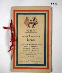
Booklet - BOOKLET, COMPLIMENTARY DINNER, Cambridge Press, Engravers and Printers, 1919
... pioneer Battalion, enlisted 10 July 1915, Ret 30 August 1919. Driver H.V. Lansell, 3rd A.M.T. Coy. Enlisted 27 April 1916, Returned 19 July 1919. Private P. Fogarty, 6th Battalion Enlisted 17 July 1915, Returned 17 July 1919. Driver F.A. McEwan, 29th Battalion, enlisted 12 July 1915, Returned 1 Oct 1918. Passchendaele Barracks Trust Booklet Complimentary Dinne M.M. Barnett H.V. Lansell P. Fogarty F.A. McEwan C.C.H. Complimentary Dinner. Tended to STF>SGT M.M. Barnett MSM., Driver H.V. Lansell, Private P.J. Fogarty, Private F.A. McEwan, by a few friends on their return from the Great European ...STF.SGT M.M. Barnett M.S.M., 1st pioneer Battalion, enlisted 10 July 1915, Ret 30 August 1919. Driver H.V. Lansell, 3rd A.M.T. Coy. Enlisted 27 April 1916, Returned 19 July 1919. Private P. Fogarty, 6th Battalion Enlisted 17 July 1915, Returned 17 July 1919. Driver F.A. McEwan, 29th Battalion, enlisted 12 July 1915, Returned 1 Oct 1918.Booklet - Cream coloured cardboard of 6 pages. Red and blue striped borders, red ribbon spine attachment. Page 1. - photograph, colour patch, page 2. Photograph colour patch. Page 3. Menu. Page 4. Programme, Page 5, Photographs, Colour patch, Page 6 Photograph, Colour patch.C.C.H. Complimentary Dinner. Tended to STF>SGT M.M. Barnett MSM., Driver H.V. Lansell, Private P.J. Fogarty, Private F.A. McEwan, by a few friends on their return from the Great European War. His Worship the Mayor of Bendigo (Cr. J.H. Curnow) will preside. Sept 25, 1919, City Club Hotel, Bendigo.passchendaele barracks trust, booklet, complimentary dinne, m.m. barnett, h.v. lansell, p. fogarty, f.a. mcewan -
 Kiewa Valley Historical Society
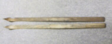
Skis, 1944-45
... European workers to the Hydro scheme thought that Falls Creek would make a good skiing village. The first ski lodge being opened in 1947. These skiis would have been used in those first seasons of Falls Creek and used by the first skiers of the time from 1945 onwards. These skiis are historically and socially significant, as they would have been one of the first type of skiis used at Falls Creek, one of Victoria first ski resorts, and used by the pioneers of skiing in Victoria. ...Skiing was first done at Falls Creek with the building of the towns of Bogong and Mt Beauty. European workers to the Hydro scheme thought that Falls Creek would make a good skiing village. The first ski lodge being opened in 1947. These skiis would have been used in those first seasons of Falls Creek and used by the first skiers of the time from 1945 onwards.These skiis are historically and socially significant, as they would have been one of the first type of skiis used at Falls Creek, one of Victoria first ski resorts, and used by the pioneers of skiing in Victoria. This item has good interpretive capacity as it shows the style of skiis that were used in the 1940's and they are a good comparative item against modern skiis. These skiis were used by Bill Bertram during the first winter traverse from Mount Hotham to the Mountain Creek base of Mount Bogong, see KVHS 0161 for biography of this historical event.Painted Red base with blue undercoat with center groove from base to 3/4 of way towards tip At tips are square pices with round holes possbily HOME MADE? 21 plus 2 holes on top face (for binding)sport, pioneers, snow, skiis, skiing, falls-creek, bogong-village, mt-beauty -
 Kiewa Valley Historical Society
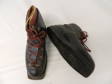
Ski Boots - Cross Country, mid 1900's
... pioneer ski recreational sport in the Victoria Alps. The mid 1900's saw the Victorian Alps begin to be used for recreational skiing, especially cross country. The majority of skiers at this point in time were either from the SEC Vic. Kiewa Hydro Scheme or from Melbourne. International skiers had better ski fields (ski lodges etc.) in Europe...pioneer ski recreational sport in the Victoria Alps. The mid 1900's saw the Victorian Alps begin to be used for recreational skiing, especially cross country. The majority of skiers at this point in time were either from the SEC Vic. Kiewa Hydro Scheme or from Melbourne. International skiers had better ski fields (ski lodges etc.) in Europe ...These cross country ski boots are part of the pioneer ski recreational sport in the Victoria Alps. The mid 1900's saw the Victorian Alps begin to be used for recreational skiing, especially cross country. The majority of skiers at this point in time were either from the SEC Vic. Kiewa Hydro Scheme or from Melbourne. International skiers had better ski fields (ski lodges etc.) in Europe, the U.S.A. and Canada. With greater and better coverage of the Winter Olympics and some medal wins, skiing became more interesting and rewarding for city dwellers in Melbourne and Sydney.These ski boots are of great significance to the Kiewa Valley as it demonstrates that winter sports in the region have and still do attract not only skiers but also provide an employment (even though seasonal) avenue which "livens up" a small rural community and provides for a diversity of land usage which did not exist in the 1800's. These brown cross country ski boots, "Grief" brand have "cherry" inserts with cream laces, within the main boot. The boots have red and black laces and crossover tie flaps (to allow for maximum front foot entry. These boots do not have any ski clips to hold firm those restraints (quick release) on the skis (like "modern boots and skis). The heel section has the red Greif "W" pattern.At the underside of the rubber sole in freehand script "Cresta"snow skiing, ski boots, winter recreational sports. -
 Orbost & District Historical Society
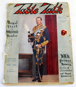
magazine, Table Talk, August 1 1934
... Orbost & District Historical Society Ruskin Street Orbost gippsland This magazine was published as a souvenir to commemorate the centenary of European settlement in Victoria, 1934 tourism recreation history Melbourne magazine Table-Talk A 104 page soft covered magazine relating to Melbourne's first 100 years. It contains stories about the settlement of early Melbourne, businesses, land purchases and advertisements. The front cover has a brown background and a colour reproduction of a painting titled Pioneers ...This magazine was published as a souvenir to commemorate the centenary of European settlement in Victoria, 1934A 104 page soft covered magazine relating to Melbourne's first 100 years. It contains stories about the settlement of early Melbourne, businesses, land purchases and advertisements. The front cover has a brown background and a colour reproduction of a painting titled Pioneers by W. B. McInnes.tourism recreation history melbourne magazine table-talk -
 Orbost & District Historical Society
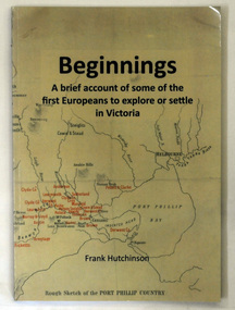
book, Beginnngs, 2011
... Pioneers Group) When he commenced the research and writing of Beginnings, it was not intended for publication. It was a project of personal interest. Hutchinson-Frank history-Victoria Prahran-Mechanics-Institute A soft covered 122 pp book title Beginnings a brief account of the first Europeans to explore or settle in Victoria. ..."A map on the wall of his parent's shop in country Victoria is what got Frank Hutchinson interested in the geography and early settlement of Victoria. He later moved to Ballarat where he spent most of his working life. Whilst there his interest in the early explorers continued until about ten years ago he began to compile the listing which developed into the present publication." (ref.Port Phillip Pioneers Group) When he commenced the research and writing of Beginnings, it was not intended for publication. It was a project of personal interest. A soft covered 122 pp book title Beginnings a brief account of the first Europeans to explore or settle in Victoria. On the glossy front cover is a rough map of Port Phillip Bay. Print is black. a chronological list of the earliest visits to Victoria and attempts to settle. The book contains: brief notes on the exploration and earliest settlement of the state, region by region and a summary of the early Murray River paddle steamer industry.hutchinson-frank history-victoria prahran-mechanics-institute -
 Lara RSL Sub Branch
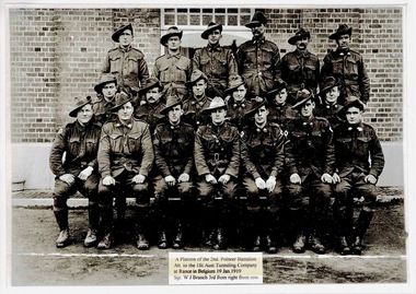
Photograph, A Platoon of the 2nd, Pioneer Battalion Att. to the 1St.Aust. Tunneling Company at Rance in Belgium 19 Jan 1919
... The 2nd Pioneer Battalion was an Australian infantry and light engineer unit raised for service during the First World War as part of the all volunteer Australian Imperial Force. Formed in Egypt in March 1916, the battalion subsequently served on the Western Front in France and Belgium, after being transferred to the European battlefields shortly after its establishment. ...Lara RSL Sub Branch McClelland Ave Lara The 2nd Pioneer Battalion was an Australian infantry and light engineer unit raised for service during the First World War as part of the all volunteer Australian Imperial Force. Formed in Egypt in March 1916, the battalion subsequently served on the Western Front in France and Belgium, after being transferred to the European battlefields shortly after its establishment. army, rance belgium,australian army, lara r.s.l. ! ...The 2nd Pioneer Battalion was an Australian infantry and light engineer unit raised for service during the First World War as part of the all volunteer Australian Imperial Force. Formed in Egypt in March 1916, the battalion subsequently served on the Western Front in France and Belgium, after being transferred to the European battlefields shortly after its establishment. Rectangular shaped black and white Photograph.A Platoon of the 2nd, Pioneer Battalion Att. to the 1St.Aust. Tunnelling Company at Rance in Belgium 19 Jan 1919 Sgt. W J Branch 3rd from right front row. army, rance belgium,australian army, lara r.s.l., !st.australian tunnelling company, 2nd pioneer battalion. -
 Eltham District Historical Society Inc
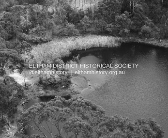
Photograph - Digital Photograph, Alan King, Blue Lake, Plenty Gorge Park, 2008
... European settlers. By 1837 squatters had claimed large runs of land for their sheep and cattle. The Plenty Valley was among the first in the Port Phillip District to be settled - mainly in the less heavily timbered west - and was proclaimed a settled district in 1841.But by the late 1880s, the settlers’ extensive land clearing for animal grazing, then agriculture, depleted the Wurundjeri’s traditional food sources, which helped to drive them away. Many Wurundjeri artefacts remain (now government protected), and so far 57 sites have been identified in the park, including scarred trees, burial areas and stone artefacts. Pioneer...European settlers. By 1837 squatters had claimed large runs of land for their sheep and cattle. The Plenty Valley was among the first in the Port Phillip District to be settled - mainly in the less heavily timbered west - and was proclaimed a settled district in 1841.But by the late 1880s, the settlers’ extensive land clearing for animal grazing, then agriculture, depleted the Wurundjeri’s traditional food sources, which helped to drive them away. Many Wurundjeri artefacts remain (now government protected), and so far 57 sites have been identified in the park, including scarred trees, burial areas and stone artefacts. Pioneer ...A quarry was transformed into the Blue Lake. Published: Nillumbik Now and Then / Marguerite Marshall 2008; photographs Alan King with Marguerite Marshall.; p179 The dramatic steep-sided Plenty Gorge lies along the divide of two geological areas, and separates the Nillumbik Shire and the City of Whittlesea. On the Nillumbik side are undulating hills and sedimentary rock, and in Whittlesea, lies a basalt plain formed by volcanic action up to two million years ago. This provides the Plenty Gorge Park with diverse vegetation and habitats, making it one of Greater Melbourne’s most important refuges for threatened and significant species. The park, established in 1986, consists of around 1350 hectares, and extends 11 kilometres along the Plenty River, from Greensborough to Mernda. It provides a wildlife corridor for around 500 native plant and 280 animal species. The area’s plentiful food and water attracted the Wurundjeri Aboriginal people and then European settlers. By 1837 squatters had claimed large runs of land for their sheep and cattle. The Plenty Valley was among the first in the Port Phillip District to be settled - mainly in the less heavily timbered west - and was proclaimed a settled district in 1841.But by the late 1880s, the settlers’ extensive land clearing for animal grazing, then agriculture, depleted the Wurundjeri’s traditional food sources, which helped to drive them away. Many Wurundjeri artefacts remain (now government protected), and so far 57 sites have been identified in the park, including scarred trees, burial areas and stone artefacts. Pioneer life could be very hard because of isolation, flooding, bushfires and bushrangers. Following the Black Thursday bushfires of 1851, basalt was quarried to build more fire-resistant homes. Gold discoveries in the early 1850s swelled the population, particularly around Smugglers Gully; but food production made more of an impact. In the late 1850s wheat production supplanted grazing. In the 1860s the government made small holdings available to poorer settlers. These had the greatest effect on the district, particularly in Doreen and Yarrambat, where orchards were established from the 1880s to 1914. Links with a prominent early family are the remains of Stuchbery Farm, by the river’s edge bounded by Smugglers Gully to the north and La Trobe Road, Yarrambat, to the east. The Stuchberys moved to the valley in 1890, and the family still lives in the area. In 1890, Alfred and Ada first lived in a tent where four children were born, then Alfred built the house and outbuildings around 1896. They planted an orchard, then a market garden, and developed a dairy. The family belonged to the local Methodist and tennis communities. Their grandson Walter, opened the Flying Scotsman Model Railway Museum in Yarrambat, which his widow, Vi, continues to run. Wal was also the Yarrambat CFA Captain for 22 years until 1987. Walter sold 24 hectares in 1976 for development - now Vista Court - and in 1990, the remaining 22.6 hectares for the park. Remaining are an early stone dairy and remnants of a stone barn, a pig sty and a well. Until it was destroyed by fire in 2003, a slab hut stood on the Happy Hollow Farm site, at the southern end of the park. The hut is thought to have been built in the Depression around 1893. This was a rare and late example of a slab hut with a domestic orchard close to Melbourne. Emmet Watmough and his family first occupied the hut, followed by a succession of families, until the Bell family bought it around 1948. There they led a subsistence lifestyle for 50 years, despite encroaching Melbourne suburbia. The Yellow Gum Recreation Area includes the Blue Lake, coloured turquoise at certain times of the year. Following the 1957 bushfires, this area was quarried by Reid Quarries Pty Ltd for Melbourne’s first skyscrapers, then by Boral Australia. However in the early 1970s water began seeping into the quarry forming the Blue Lake and the quarry was closed. The State Government bought the site in 1997 and opened it as a park in 1999.This collection of almost 130 photos about places and people within the Shire of Nillumbik, an urban and rural municipality in Melbourne's north, contributes to an understanding of the history of the Shire. Published in 2008 immediately prior to the Black Saturday bushfires of February 7, 2009, it documents sites that were impacted, and in some cases destroyed by the fires. It includes photographs taken especially for the publication, creating a unique time capsule representing the Shire in the early 21st century. It remains the most recent comprehenesive publication devoted to the Shire's history connecting local residents to the past. nillumbik now and then (marshall-king) collection, blue lake, plenty gorge park -
 Eltham District Historical Society Inc
Photograph - Digital Photograph, Marguerite Marshall, Stuchbery Farm dairy, 14 March 2008
... European settlers. By 1837 squatters had claimed large runs of land for their sheep and cattle. The Plenty Valley was among the first in the Port Phillip District to be settled - mainly in the less heavily timbered west - and was proclaimed a settled district in 1841. But by the late 1880s, the settlers’ extensive land clearing for animal grazing, then agriculture, depleted the Wurundjeri’s traditional food sources, which helped to drive them away. Many Wurundjeri artefacts remain (now government protected), and so far 57 sites have been identified in the park, including scarred trees, burial areas and stone artefacts. Pioneer...European settlers. By 1837 squatters had claimed large runs of land for their sheep and cattle. The Plenty Valley was among the first in the Port Phillip District to be settled - mainly in the less heavily timbered west - and was proclaimed a settled district in 1841. But by the late 1880s, the settlers’ extensive land clearing for animal grazing, then agriculture, depleted the Wurundjeri’s traditional food sources, which helped to drive them away. Many Wurundjeri artefacts remain (now government protected), and so far 57 sites have been identified in the park, including scarred trees, burial areas and stone artefacts. Pioneer ...Stuchbery Farm was situated on the Plenty River bounded by Smugglers Gully to the north and La trobe Road, Yarrambat, to the east. Alan and Ada Stutchbery moved to the valley in 1890, first living in a tent where four children were born. Alfred built a home and outbuildings around 1896. They planted an orchard, then a market garden and developed a dairy. Published: Nillumbik Now and Then / Marguerite Marshall 2008; photographs Alan King with Marguerite Marshall.; p179 The dramatic steep-sided Plenty Gorge lies along the divide of two geological areas, and separates the Nillumbik Shire and the City of Whittlesea. On the Nillumbik side are undulating hills and sedimentary rock, and in Whittlesea, lies a basalt plain formed by volcanic action up to two million years ago. This provides the Plenty Gorge Park with diverse vegetation and habitats, making it one of Greater Melbourne’s most important refuges for threatened and significant species. The park, established in 1986, consists of around 1350 hectares, and extends 11 kilometres along the Plenty River, from Greensborough to Mernda. It provides a wildlife corridor for around 500 native plant and 280 animal species. The area’s plentiful food and water attracted the Wurundjeri Aboriginal people and then European settlers. By 1837 squatters had claimed large runs of land for their sheep and cattle. The Plenty Valley was among the first in the Port Phillip District to be settled - mainly in the less heavily timbered west - and was proclaimed a settled district in 1841. But by the late 1880s, the settlers’ extensive land clearing for animal grazing, then agriculture, depleted the Wurundjeri’s traditional food sources, which helped to drive them away. Many Wurundjeri artefacts remain (now government protected), and so far 57 sites have been identified in the park, including scarred trees, burial areas and stone artefacts. Pioneer life could be very hard because of isolation, flooding, bushfires and bushrangers. Following the Black Thursday bushfires of 1851, basalt was quarried to build more fire-resistant homes. Gold discoveries in the early 1850s swelled the population, particularly around Smugglers Gully; but food production made more of an impact. In the late 1850s wheat production supplanted grazing. In the 1860s the government made small holdings available to poorer settlers. These had the greatest effect on the district, particularly in Doreen and Yarrambat, where orchards were established from the 1880s to 1914. Links with a prominent early family are the remains of Stuchbery Farm, by the river’s edge bounded by Smugglers Gully to the north and La Trobe Road, Yarrambat, to the east. The Stuchberys moved to the valley in 1890, and the family still lives in the area. In 1890, Alfred and Ada first lived in a tent where four children were born, then Alfred built the house and outbuildings around 1896. They planted an orchard, then a market garden, and developed a dairy. The family belonged to the local Methodist and tennis communities. Their grandson Walter, opened the Flying Scotsman Model Railway Museum in Yarrambat, which his widow, Vi, continues to run. Wal was also the Yarrambat CFA Captain for 22 years until 1987. Walter sold 24 hectares in 1976 for development - now Vista Court - and in 1990, the remaining 22.6 hectares for the park. Remaining are an early stone dairy and remnants of a stone barn, a pig sty and a well. Until it was destroyed by fire in 2003, a slab hut stood on the Happy Hollow Farm site, at the southern end of the park. The hut is thought to have been built in the Depression around 1893. This was a rare and late example of a slab hut with a domestic orchard close to Melbourne. Emmet Watmough and his family first occupied the hut, followed by a succession of families, until the Bell family bought it around 1948. There they led a subsistence lifestyle for 50 years, despite encroaching Melbourne suburbia. The Yellow Gum Recreation Area includes the Blue Lake, coloured turquoise at certain times of the year. Following the 1957 bushfires, this area was quarried by Reid Quarries Pty Ltd for Melbourne’s first skyscrapers, then by Boral Australia. However in the early 1970s water began seeping into the quarry forming the Blue Lake and the quarry was closed. The State Government bought the site in 1997 and opened it as a park in 1999.This collection of almost 130 photos about places and people within the Shire of Nillumbik, an urban and rural municipality in Melbourne's north, contributes to an understanding of the history of the Shire. Published in 2008 immediately prior to the Black Saturday bushfires of February 7, 2009, it documents sites that were impacted, and in some cases destroyed by the fires. It includes photographs taken especially for the publication, creating a unique time capsule representing the Shire in the early 21st century. It remains the most recent comprehenesive publication devoted to the Shire's history connecting local residents to the past. nillumbik now and then (marshall-king) collection, ada stuchbery, alan stuchbery, dairy, stuchbery farm, farm buildings, yarrambat, plenty gorge park -
 Eltham District Historical Society Inc
Photograph, Fay Bridge, Rosehill Homestead, EDHS Heritage Excursion, 6 July 2019
... The walk also includes parts of the historic Cleveland Estate and the homestead “Rosehill” established by pioneer farmer Henry Stooke. This area was the site of the first recorded European settlement in what was to become the Shire of Eltham when the Willis brothers arrived in the late 1830s. ...The walk also includes parts of the historic Cleveland Estate and the homestead “Rosehill” established by pioneer farmer Henry Stooke. This area was the site of the first recorded European settlement in what was to become the Shire of Eltham when the Willis brothers arrived in the late 1830s. ...July Excursion July 6, 2019 - Exploring Lower Plenty The predominant feature of this walk in the Bonds Road area, Lower Plenty is the large number of magnificent old River Red Gums that line the route. These trees are of the spreading woodland form of this species indicating that they must have been originally growing in a reasonably open setting. The walk also includes parts of the historic Cleveland Estate and the homestead “Rosehill” established by pioneer farmer Henry Stooke. This area was the site of the first recorded European settlement in what was to become the Shire of Eltham when the Willis brothers arrived in the late 1830s. From the southern part of Cleveland Avenue there are extensive views across and along the Yarra Valley. An article on the history of this area was contained in Newsletter edition 201, November 2011. The walk will start at the at the corner of Bonds and Stawell Roads, Lower Plenty - EDHS Newsletter No. 246 June 2019fay bridge collection, 2019-07-06, blackburn bricks, eltham district historical society, heritage excursion, rosehill homestead, lower plenty -
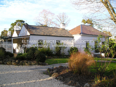
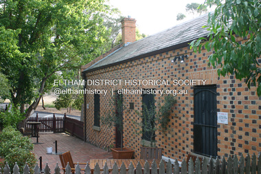 Eltham District Historical Society Inc
Photograph - Digital Photograph, Alan King, Shillinglaw Cottage, 6 January 2008
... pioneer builder George Stebbing, is one of Eltham’s earliest buildings and associated with significant early settlers. It is on the National Estate and National Trust Registers. The cottage was constructed with handmade bricks in the Flemish Bond style, typical of cottages and farmhouses in Flanders, Europe. ...pioneer builder George Stebbing, is one of Eltham’s earliest buildings and associated with significant early settlers. It is on the National Estate and National Trust Registers. The cottage was constructed with handmade bricks in the Flemish Bond style, typical of cottages and farmhouses in Flanders, Europe. ...Covered under National Estate, National Trust of Australia (Victoria) Local Significance and Heritage Overlay, Nillumbik Planning Scheme. Published: Nillumbik Now and Then / Marguerite Marshall 2008; photographs Alan King with Marguerite Marshall.; p95 Thanks to an Australia first effort by local residents, the historic Shillinglaw Cottage still survives. The cottage at Panther Place, Eltham, once stood about 100 metres away on Main Road. But in 1963 it faced demolition to make room for the Eltham Shire Offices (since demolished). However residents rallied to save Shillinglaw Cottage and became the first in Australia to remove and reconstruct an early settler’s brick building. A fundraiser was the residents’ compilation of loved recipes into the cookery book, Flavour of Eltham. The cottage, built in the late 1870s by noted pioneer builder George Stebbing, is one of Eltham’s earliest buildings and associated with significant early settlers. It is on the National Estate and National Trust Registers. The cottage was constructed with handmade bricks in the Flemish Bond style, typical of cottages and farmhouses in Flanders, Europe. It features burnt ‘header’ bricks over the façade, which gives a chequered effect. The roof is made of slate, while the windows are 12-paned sash with relieving arches. It is not clear who were the first owners of the cottage. The National Trust claims that Stebbing built it for farmer Thomas Cochrane.1 Others say Cochrane first owned the land but Stebbing was Shillinglaw’s first owner and remained so until 1887. The Shillinglaw family then bought it and lived there for around 80 years until 1963 when they sold it to the Eltham Council.2 Farmer Thomas Cochrane bought the Shillinglaw Cottage site from land developer Josiah Holloway. The site was the largest in what Holloway called Little Eltham, of some 30 acres (12 ha), extending along the creek from Henry Street to Luck Street. In 1874 Cochrane sold the land to George Stebbing. Meanwhile in 1861, Stebbing was the owner and occupier of a house at Pitt Street, Eltham, which he had built. Evelyn Observer journalist James Rossiter rented the Pitt Street house, then in 1881 Phillip Shillinglaw occupied it. Stebbing constructed several buildings of note in the area, including the Uniting Church at John Street, the building beside it – a former bank – and St Margaret’s Church of England in Pitt Street. Stebbing was also an Eltham Shire Councillor from 1871 to 1873 and a trustee and treasurer of the Eltham Wesleyan Church.3 In the 1870s he is recorded as the owner of up to five houses. Earlier he had been described as a bricklayer and later became a farmer. In 1882 Stebbing returned to the Pitt Street house and Shillinglaw occupied the new house in Main Road, which he owned from 1887. Shillinglaw was a prolific poet and preached at the Eltham Primitive Methodist Church, where he also served as Sunday School superintendent and led the Young People’s Society Christian Endeavour. The Shillinglaws saw many changes in their property’s boundaries – the major one occurring at the turn of the century when land for the railway and Eltham station was acquired from their holding. The northern part of the remaining land was then used for some of the first commercial developments in what was to become the Eltham Shopping Centre. Later still, the land immediately north of the cottage was bought by the Eltham War Memorial Trust for the War Memorial Buildings and the fire station. The Trust’s land eventually passed to the council. The council bought the remaining two acres (0.8 ha) with the house, and with the exception of the commercial development between the fire station and the post office, all of the former Shillinglaw land is owned by the council or government instrumentalities.4 Since the late 20th century, the cottage has had varied uses, such as a handcrafts store and as a restaurant.This collection of almost 130 photos about places and people within the Shire of Nillumbik, an urban and rural municipality in Melbourne's north, contributes to an understanding of the history of the Shire. Published in 2008 immediately prior to the Black Saturday bushfires of February 7, 2009, it documents sites that were impacted, and in some cases destroyed by the fires. It includes photographs taken especially for the publication, creating a unique time capsule representing the Shire in the early 21st century. It remains the most recent comprehenesive publication devoted to the Shire's history connecting local residents to the past. nillumbik now and then (marshall-king) collection, shillinglaw cottage -
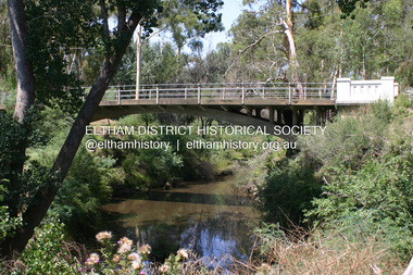 Eltham District Historical Society Inc
Photograph - Digital Photograph, Alan King, Monash Bridge, Hurstbridge, 23 January 2008
... It is unusual in Victoria, but similar to many reinforced concrete arch bridges in Europe and America, built from the late 19th century. In Victoria, Monash pioneered the use of reinforced concrete – then a revolutionary construction material. ...It is unusual in Victoria, but similar to many reinforced concrete arch bridges in Europe and America, built from the late 19th century. In Victoria, Monash pioneered the use of reinforced concrete – then a revolutionary construction material. ...Monash Bridge spans the Diamond Creek at Hurstbridge. It was built in 1917 for the Shires of Heidelberg, Eltham and Whittlesea. It is considered Nillumbik Shire's finest engineered bridge and was construced by the engineering company of Sir John Monash. Covered under Heritage Overlay, Nillumbik Planning Scheme. Published: Nillumbik Now and Then / Marguerite Marshall 2008; photographs Alan King with Marguerite Marshall.; p117 Monash Bridge is considered the Shire’s finest engineered bridge and was constructed by the engineering company of that great Australian, Sir John Monash.1 The bridge spans Diamond Creek on the Hurstbridge-Arthurs Creek Road, linking Hurstbridge with Yarrambat and Arthurs Creek. Monash Bridge, also called Hurst’s Bridge, was built in 1917, by the Reinforced Concrete and Monier Pipe Construction Company Pty Ltd, for the Shires of Heidelberg, Eltham and Whittlesea. Although Monash was probably in action overseas during World War One when the bridge was designed and constructed, he evolved the basic design in the 1900s and it was a standard design for the firm. However J A Laing, a designer at the firm, was probably the designer, as his initials are on bridge drawings held by the Eltham District Historical Society.2 The bridge is an excellent early Australian example of an open spandrel reinforced concrete arch bridge and has a single span of 29 metres. It is unusual in Victoria, but similar to many reinforced concrete arch bridges in Europe and America, built from the late 19th century. In Victoria, Monash pioneered the use of reinforced concrete – then a revolutionary construction material. His company, Monash & Anderson, had the exclusive licence for the Monier patent for the system of reinforced concrete construction for Victoria and New South Wales. A well-known example of the Monier arch bridge is the Morell Bridge in South Yarra. The sweeping arch of the Monash Bridge combines grace and utility and blends with the surrounding rural landscape. Its design and construction have allowed it to carry increasing volumes of heavy traffic, but in modern times the one lane is considered by some to prevent easy passage through Hurstbridge. However others consider this an asset to deter too much more traffic, which would diminish Hurstbridge’s charming rural character.3 This is the third bridge across the Diamond Creek at this site. The original bridge was a log bridge upstream, constructed in the 1850s by early settler, Henry Hurst, after whom Hurstbridge was named. The bridge spanned the creek, where it divided his family’s property. In the 1880s a timber bridge replaced it, known as Hurst’s Bridge. However a more permanent bridge was considered necessary when the new railway arrived in 1912, bringing with it expectations of growth in the town and the surrounding fruit-growing district. Monash Bridge’s official opening on November 3, 1917 was a gala occasion, which took place before about 1000 spectators. Two who attended the opening had a particularly sound knowledge of the locality. One was Fred Hurst, Henry’s brother, who used to ford the creek at or near the bridge’s site more than 50 years before. The other was John McDonald of Arthurs Creek, who had built the old wooden bridge over the creek about 40 years earlier.4 Although John Monash was a fine engineer, his fame came from his brilliant war career, rather than from his engineering or his many other achievements. Monash was Corps Commander of the Australian Forces. His brilliance was recognised with his awards: Knight Grand Cross of the Order of St. Michael and St. George, and Knight Commander of the Bath. Monash was also decorated by the French, Belgian, and American Governments.5 After the war, Monash worked in many prominent civilian positions, the most notable as head of the Victorian State Electricity Commission. He was a leading and loved public figure, involved in many public and private organisations. He was president of the Australian Zionist Federation and involved in the Boy Scouts. Monash University is named after him. By the 1920s Monash was probably regarded as the greatest living Australian.6 Despite most of his life working as an administrator and leader, rather than a fighting soldier, he became integral to the ANZAC legend. Monash died in 1931.This collection of almost 130 photos about places and people within the Shire of Nillumbik, an urban and rural municipality in Melbourne's north, contributes to an understanding of the history of the Shire. Published in 2008 immediately prior to the Black Saturday bushfires of February 7, 2009, it documents sites that were impacted, and in some cases destroyed by the fires. It includes photographs taken especially for the publication, creating a unique time capsule representing the Shire in the early 21st century. It remains the most recent comprehenesive publication devoted to the Shire's history connecting local residents to the past. nillumbik now and then (marshall-king) collection, hurstbridge, monash bridge -
Glen Eira Historical Society
Document - Bakewell Family
... There are 3 items about this family of early European settlers in Victoria: 1/A photocopy of an extract “Early Pioneer Families of Victoria and Riverina” – Henderson Page 441-442 The Bakewell Family of Burnewang and Tooradin”. ...Glen Eira Historical Society 965 Glen Huntly Rd Caulfield VIC 3162 melbourne There are 3 items about this family of early European settlers in Victoria: 1/A photocopy of an extract “Early Pioneer Families of Victoria and Riverina” – Henderson Page 441-442 The Bakewell Family of Burnewang and Tooradin”. ...There are 3 items about this family of early European settlers in Victoria: 1/A photocopy of an extract “Early Pioneer Families of Victoria and Riverina” – Henderson Page 441-442 The Bakewell Family of Burnewang and Tooradin”. It includes a photo of John Bakewell (1807-1888). It contains two pages and describes Bakewell’s property expansion. 2/An original copy of handwritten, unsigned undated research notes on John Bakewell property holdings taken from St Kilda Rate Book (1859-1873). It describes the land allotment. 3/A typed, unsigned, undated extract from 'The Howitts in Australia by Mary Howitt' - Mary Howitt, Vic Hist Mag 1913 Vol 3 No. 1. Reference – Memoirs of a Stockman, Harry Peck, 1853 Map, Foot Plot CCXLVI at Kooyong & Glen Eira Road. It provides a brief outline of the lives of brothers Robert and John Bakewell.the bakewell family, early pioneer families, henderson, bakewell john, port phillip, burnewang, bakewell robert, howitt godfrey dr, lord goderich, tooradin, phoebe, friends' school ackworth, yorkshire, nottingham, shaw john wyberg, plenty river, businesses, goldsbrough richard, goldsbrough mort and company ltd., glaziers, squatters, burnewang, mantons, tooradin, red bluff, torbinurruck, great swamp, brenanah, westernport, numerella, snowy river, orbost, green hills b, caramut, lyall william, mickle john, buckland john, notts, england, balderton, weddings, jane emily, howitt emanuel, farnsfield, lever mary, howitt thomas, heanor, derbyshire, howitt godfrey, scales john, exeter college oxford, downing college cambridge, guerard von, wayne john, south warnborough manor, harrison robert, lord john, jamaica, mary alice, dr. miller, miller john francis compton, emmie joan, mary emily, clifton hotel welbeck street, phoebe alice, anne edith, british museum, land values, settlements, st. kilda, elsternwick, inkerman street, st. kilda east, kew, memoirs of a stockman, harry peck -
 Bendigo Historical Society Inc.
Document - LONG GULLY HISTORY GROUP COLLECTION: THE BENDIGO POST OFFICE
... History House 11 Mackenzie Street Bendigo goldfields BENDIGO History long gully history group The Long Gully History Group - The Bendigo Post Office L C Bennetts Mt Alexander Post Office Porcupine Inn Cenotaph Pike or Pyke Baby Health Centre Sandhurst Post Office Government Survey Office Queen Elizabeth Oval Sandhurst Trustees Company Mr H B Briston Savings Bank Telegraph Office The Sub-Treasury Sir Henry Brougham Lock KCB Sir John Nimmo MLA Prince of Wales group of mines The New Prince of Wales Eaglehawk Golf Links New Prince of Wales No 2 The Whip and Jersey Mines Department Lansell's Big 180 New Chum and Victoria Mine and Battery New Chum Railway Koch's Pioneer South New Moon Catherine Reef United New Moon The Virginia South Bell Vue Central Nell Gwynne North Nell Gwynne Miner's Phthisis Hercules Engine House Ironbark New Chum Syncline Hercules Energetic Roberts & Sons Harkness & Co Horwoods Great Southern Ulster Carlisle Lansells Big 180 Victoria Quartz New St Mungo Duchess Tribute South Devonshire Hopewell Mine Saxby Mine McNair & Co Shamrock Mr King Burke and Wills Expedition Sandhurst Hotel Courthouse Hiberian The Freemasons The Courthouse The Commercial Law Courts The Hamburg The European The Prince Bismark The Lord Kitchener The Bendigo The Rosalind Park The Showgrounds Atheneum Club Olivers Bridge Hotel Bourkes The Globe The Hibernia Albert Albion Abbotts Australian Belvidere Beehive British Queen Black Eagle British and American Brian Boru Bakers Arms Butchers Arms Brick Layers Arms Bull and Mouth Cresent Clarence Back Creek Bridge Cape Clear Crooked Billet Cambridgeshire Arms Camp Coach and Horses Cricketers Arms Diggers Rest Ellesmere Five Lions Franklyn Golden Square Golden Gate Golden Gully Golden Age Golden Vine Gumtree Glasgow Reef Great Britain Haymarket Daniel O'Connell Half Way House Fleece Inn Ironbark Johnsons Reef Lancashire Live and Let Live Manchester Arms Gold Mines Metropolitan Crown National New Chum Honeysuckle Street Pavilion Napier Arms Quartz Miners Arms Retreat Inn Rainbow Rose of Australia Lake View Robin Hood Fountain Southern Cross Bath Berlin Spring Gully Star Sir Charles Hotham Silvermines Royal Oak Suburban Town Hall Temperance Ship Inn View Point View Bend Victoria Exchange American Arcade Belfast All Nations Union United Kingdom Union Jack Westend Washington Waterloo Wellington Whitehorse Wheat Sheaf Yorkshire Niagra Noahs Ark Article titled The Bendigo Post Office, compiled by L C Bennetts. ...Article titled The Bendigo Post Office, compiled by L C Bennetts. Mentioned is the history of the Bendigo Post Office and postmarks, some information on mining, Bendigo foundries, Underground connections of mines, expenses and shaft sinking costs. Also mentioned is Bendigo and Eaglehawk - 60 years ago and the role the pubs played in daily living. They were where theatres, concerts and dances were held, and the meeting rooms for clubs and lodges, even church benefits. Listed is a number of Bendigo hotels. Some even had a few names. Names of the pubs are: The Freemasons, The Courthouse, The Commercial Law Courts, The Hamburg, The European, The Prince Bismark, The Lord Kitchener, The Bendigo, The Rosalind Park, The Showgrounds, Atheneum Club, Olivers, Bridge Hotel, Bourkes, The Globe, The Hibernia, Albert, Albion, Abbotts, Australian, Belvidere, Beehive, British Queen, Black Eagle, British and American, Brian Boru, Bakers Arms, Butchers Arms, Brick Layers Arms, Bull and Mouth, Cresent, Clarence, Back Creek Bridge, Cape Clear, Crooked Billet, Cambridgeshire Arms, Camp, Coach and Horses, Cricketers Arms, Diggers Rest, Ellesmere, Five Lions, Franklyn, Golden Square, Golden Gate, Golden Gully, Golden Age, Golden Vine, Gumtree, Glasgow Reef, Great Britain, Haymarket, Daniel O'Connell, Half Way House, Fleece Inn, Ironbark, Johnsons Reef, Lancashire, Live and Let Live, Manchester Arms, Gold Mines, Metropolitan, Crown, National, New Chum, Honeysuckle Street, Pavilion, Napier Arms, Quartz Miners Arms, Retreat Inn, Rainbow, Rose of Australia, Lake View, Robin Hood, Fountain, Southern Cross, Bath, Berlin, Spring Gully, Star, Sir Charles Hotham, Silvermines, Royal Oak, Suburban, Town Hall, Temperance, Ship Inn, View Point, View Bend, Victoria, Exchange, American, Arcade, Belfast, All Nations, Union, United Kingdom, Union Jack, Westend, Washington, Waterloo, Wellington, Whitehorse, Wheat Sheaf, Yorkshire, Niagra and Noahs Ark.bendigo, history, long gully history group, the long gully history group - the bendigo post office, l c bennetts, mt alexander post office, porcupine inn, cenotaph, pike or pyke, baby health centre, sandhurst post office, government survey office, queen elizabeth oval, sandhurst trustees company, mr h b briston, savings bank, telegraph office, the sub-treasury, sir henry brougham lock kcb, sir john nimmo mla, prince of wales group of mines, the new prince of wales, eaglehawk golf links, new prince of wales no 2, the whip and jersey, mines department, lansell's big 180, new chum and victoria mine and battery, new chum railway, koch's pioneer, south new moon, catherine reef united, new moon, the virginia, south bell vue, central nell gwynne, north nell gwynne, miner's phthisis, hercules engine house, ironbark, new chum syncline, hercules energetic, roberts & sons, harkness & co, horwoods, great southern, ulster, carlisle, lansells big 180, victoria quartz, new st mungo, duchess tribute, south devonshire, hopewell mine, saxby mine, mcnair & co, shamrock, mr king, burke and wills expedition, sandhurst hotel, courthouse, hiberian, the freemasons, the courthouse, the commercial law courts, the hamburg, the european, the prince bismark, the lord kitchener, the bendigo, the rosalind park, the showgrounds, atheneum club, olivers, bridge hotel, bourkes, the globe, the hibernia, albert, albion, abbotts, australian, belvidere, beehive, british queen, black eagle, british and american, brian boru, bakers arms, butchers arms, brick layers arms, bull and mouth, cresent, clarence, back creek bridge, cape clear, crooked billet, cambridgeshire arms, camp, coach and horses, cricketers arms, diggers rest, ellesmere, five lions, franklyn, golden square, golden gate, golden gully, golden age, golden vine, gumtree, glasgow reef, great britain, haymarket, daniel o'connell, half way house, fleece inn, ironbark, johnsons reef, lancashire, live and let live, manchester arms, gold mines, metropolitan, crown, national, new chum, honeysuckle street, pavilion, napier arms, quartz miners arms, retreat inn, rainbow, rose of australia, lake view, robin hood, fountain, southern cross, bath, berlin, spring gully, star, sir charles hotham, silvermines, royal oak, suburban, town hall, temperance, ship inn, view point, view bend, victoria, exchange, american, arcade, belfast, all nations, union, united kingdom, union jack, westend, washington, waterloo, wellington, whitehorse, wheat sheaf, yorkshire, niagra, noahs ark